
Abstract
River surface temperature (RST) plays a crucial role in shaping river thermal regimes and ecosystem functioning, yet seasonal and reach-scale factors influencing RST remain poorly understood. Here, we derive reach-scale RST for the Yangtze River Delta (YRD) from Landsat imagery (2010-2020) using a novel river-width-adaptive sampling method (River Surface Moving Window, RS-MW). An Extreme Gradient Boosting (XGBoost) model, in conjunction with Shapley Additive Explanations (SHAP) and a hydrological connectivity (HC) metric, is used to quantify the seasonal influence of climatic, river-characteristic, topographic and riparian-environmental factors. The results indicate that RST in the YRD increased at an annual mean rate of 0.092 °C yr−1 from 2010 to 2020, with the most pronounced seasonal warming observed in spring and winter. RST displays strong spatial heterogeneity during spring and summer and a distinct north-south gradient in autumn and winter. Climatic factors exert the strongest overall control on RST, followed by river-characteristic factors, which play a key role in shaping spatial heterogeneity and seasonal modulation, whereas topographic and riparian-environmental factors are comparatively less influential. Air temperature (Ta) is identified as the dominant warming factor, while HC effectively mitigates elevated RST, particularly in warm seasons, with SHAP-based estimates indicating a cooling contribution of approximately 1.5 °C in spring and summer, but less than 0.6 °C in autumn and winter. Riparian vegetation contributes to cooling, whereas impervious surfaces intensify thermal stress. The proposed framework offers a transferable and fine-scale approach to RST monitoring to support climate-adaptation and water-management strategies. The findings highlight that restoration of hydrological connectivity and riparian vegetation are effective strategies for mitigating the future increase in RST, with additional measures such as wetland reconstruction and the development of blue-green infrastructure further enhancing river ecosystem resilience.
Keywords
Highlights
A river-width-adaptive sampling method is developed to analyze reach-scale river surface temperature (RST).
RST warmed within the Yangtze River Delta during 2010-2020.
Air temperature (Ta) and hydrological connectivity (HC) are dominant RST factors.
High HC cools RST throughout the year and weakens the warming effects of Ta and solar radiation (Rd), especially in summer.
Restoring hydrological connectivity and riparian vegetation is pivotal to control future RST warming.
Introduction
Given the typically well-mixed nature of rivers and their vertically uniform temperature profiles, river surface temperature (RST), defined as the water temperature at the air-water interface, serves as a key indicator of river thermal regimes and ecosystem health (Caissie, 2006; Vanhellemont, 2020). RST directly or indirectly influences physicochemical properties, material cycling, biogeochemical processes, and ecosystem functioning, thereby shaping the habitats and geographic distributions of aquatic biota, particularly fish, and influencing socio-economic activities such as aquaculture (Hannah and Garner, 2015). Recent global warming and anthropogenic activities have augmented both river temperatures generally and the frequency of extreme events (e.g., river heatwaves) (Zhu et al., 2024). Climate models project these trends to continue, potentially threatening water-resource sustainability, ecosystem equilibrium, and socio-economic development (Johnson et al., 2024). Understanding these changes, therefore, requires consideration of the energy exchanges and controlling factors that shape RST.
River temperature dynamics are governed by shifts in the energy budget, including exchanges at the air-water interface, riverbed, and banks, as well as advection (Leach et al., 2023). At the broad scale, climatic and hydrological processes (e.g., air temperature, radiation, and precipitation) are widely recognized as first-order controls in determining the initial thermal conditions. At the basin and whole-river scales, catchment properties (e.g., elevation, vegetation, land use) have been identified as second-order controls, modulating energy redistribution by affecting radiation, advection, and groundwater discharge. At the reach scale, local channel morphology and topology act as third-order controls, regulating local energy exchanges through thermal insulation and buffering (Dugdale et al., 2017). Additionally, human activities (e.g., urbanization, reservoirs) further modify river thermal regimes by directly altering heat inputs and indirectly exacerbating climate warming impacts (Webb et al., 2008). Beyond these scale-dependent controls, previous studies have also proposed seasonal differences in the dominant drivers. Overall, there is broad agreement that air temperature exerts a fundamental influence on river thermal regimes across seasons. However, its relative importance varies temporally. Winter variability is often predominantly explained by air temperature, whereas summer temperatures are typically governed by a complex combination of climatic, hydrological, geomorphological, and anthropogenic factors (Wade et al., 2023). Consequently, RST commonly exhibits complex spatiotemporal heterogeneity driven by the integrated effects of multiple controlling factors.
Remote sensing provides spatially extensive and temporally continuous RST observations, with Landsat imagery widely used for its high spatial resolution. Despite the general understanding of RST, there are mixed findings regarding RST derived from thermal remote sensing. Estimates based on thermal infrared data are subject to uncertainties related to spatiotemporal resolution, river width, atmospheric correction, and sampling strategies (Dugdale, 2016). For example, pixel mixing with bank elements can cause RST overestimation (Handcock et al., 2006). Furthermore, differences in observation timing or temporal resolution can lead to inconsistent representations of thermal variability.
Apart from methodological challenges, knowledge gaps remain regarding the spatiotemporal dynamics of RST. Temporally, most studies have focused on summer or annual scales, with relatively limited attention to seasonal dynamics (Lorenzo-González et al., 2023). However, climatic factors (e.g., air temperature, solar radiation), river characteristics (e.g., flow), and environmental conditions (e.g., vegetation) are dynamic, and their regulatory effects may vary across seasons (Danehy et al., 2005; Li et al., 2021).Given evidence that seasonal modeling enhances prediction accuracy (Zhang et al., 2025), a seasonally resolved analysis of influencing factors is essential. Spatially, remote sensing-based RST investigations predominantly focus on regional, basin, or whole-river scales (Loerke et al., 2023; Sun et al., 2024; Wanders et al., 2019), which help explain overall species distribution and ecological behavior (Martí-Cardona et al., 2019). At finer scales, where adaptive management practices (e.g., riparian vegetation restoration, riverbed renovation) are primarily implemented (Dugdale et al., 2015), thermal heterogeneity is closely linked to local ecological processes, such as cold-water fish conservation, sensitive species habitats, and the formation of thermal refugia (Ouellet et al., 2020). Therefore, systematic reach-scale analysis holds considerable theoretical and applied value. Although reach-scale water temperature is jointly regulated by interactions between external factors and internal river structure (Poole and Berman, 2001), the influence of physical river characteristics, such as hydrological connectivity and river width, remains insufficiently quantified compared to extensively studied external climatic factors.
Modeling approaches play a crucial role in factor identification and mechanism exploration, mainly encompassing deterministic and statistical models. Given the nonlinear relationships between river temperatures and its drivers (Wade et al., 2023), as well as their potential interactions, machine learning methods have been increasingly applied in river temperature research in recent years (Darkwah et al., 2024). Extreme Gradient Boosting (XGBoost) can demonstrate high efficiency and robustness among gradient-boosting algorithms, yielding notable advantages in handling large datasets, missing values, and overfitting (Zhao et al., 2022). Accordingly, integrating Shapley Additive Explanations (SHAP) with XGBoost may enhance model interpretability by quantifying the relative importance of different features (Strumbelj and Kononenko, 2010).
Despite these advances, reach-scale, seasonally resolved analyses of RST and their physical drivers remain scarce. To address this shortcoming, we investigate seasonal and reach-scale controls on RST in the Yangtze River Delta (YRD), China. Landsat imagery was used to extract river boundaries and derive RST. To support automated, reach-scale analysis, we developed a novel, adaptive sampling method, viz. the River Surface Moving Window (RS-MW), which enables batch extraction of river width (RW) and corresponding RST. Hydrological connectivity (HC) was also incorporated as a key explanatory feature. By integrating Bayesian-optimized XGBoost modeling with SHAP explainability, the seasonal influence of climatic, river-characteristic, topographic, and riparian-environmental factors on RST was systematically quantified at the reach scale using extensive samples. We establish the following objectives: (1) to propose an automated sampling framework for reach-scale RST using remote sensing data; (2) to reveal spatiotemporal characteristics of RST in the YRD over the past decade; (3) to quantify the seasonal relative importance and influence characteristics of factors and elucidate their mechanisms.
Materials and methods
Study area and data collection
The YRD (Figure 1) is located at the estuary of the Yangtze River in eastern China, encompassing Shanghai Municipality and the provinces of Jiangsu, Zhejiang, and Anhui, and covering approximately 358,000 km2. The region is subdivided into eight basins (Online Supplementary Table S1), among which the Lower Yangtze River Basin, Taihu Lake Basin, and Qiantang River Basin have well-developed drainage systems. The area has a subtropical monsoon climate and is characterized by alluvial plains interspersed with hills and low mountains. In recent decades, rapid urbanization and water infrastructure development have reduced river connectivity and network density, disrupted natural hydrological regimes, and increased pollution risk (Lin et al., 2023). Against this background, and in the light of ongoing climate change and other human impacts, investigation of temporal changes in RST in the YRD is both timely and necessary.
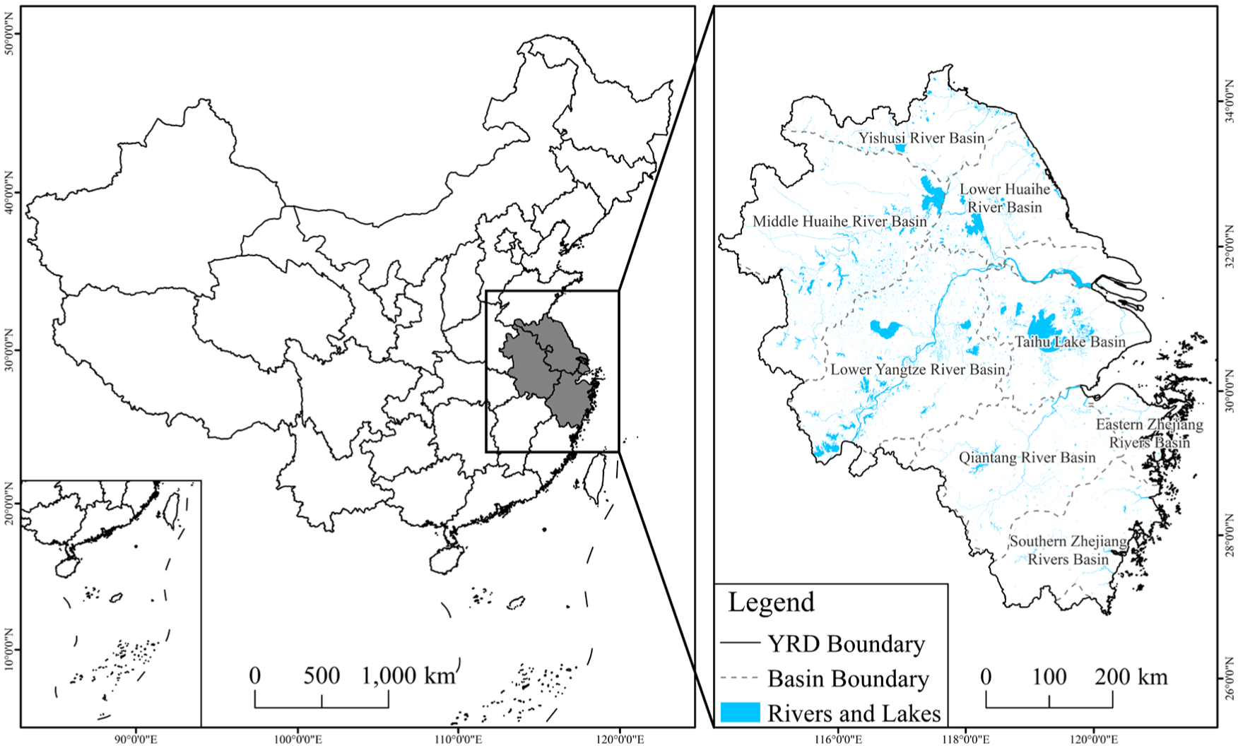
Location of the study region.
Three categories of data were utilized in this study (Online Supplementary Table S2): (i) satellite products acquired from Google Earth Engine (GEE), including Landsat 5/7/8 top-of-atmosphere (TOA) brightness temperature and surface reflectance (SR), JRC Monthly Water History (v1.4) dataset, Advanced Spaceborne Thermal Emission and Reflection Radiometer Global Emissivity Dataset (ASTER-GED v3), Shuttle Radar Topography Mission Digital Elevation Model (SRTM DEM, 30m) and MOD13Q1 V6.1; (ii) meteorological and environmental variables, comprising surface solar radiation downwards, total evaporation and 10-m wind components from ERA5-Land monthly averaged data, Total Column Water Vapor (TCWV) from NCEP/NCAR Reanalysis Data via GEE; (iii) field-measured and thematic datasets, including temperature, precipitation and relative humidity from National Tibetan Plateau Data Center (TPDC), ground surface temperature (GST) from meteorological stations, 30m annual land cover data (Yang and Huang, 2021), and the hydrological connectivity index (Li et al., 2023).
Landsat imagery was employed to retrieve surface water and land surface temperature (LST). The JRC dataset supported the synthesis of surface-water maps. TCWV and ASTER GED v3 datasets were used for LST retrieval. The remaining datasets were used to construct the features for RST modeling. All datasets were resampled to 30 m resolution, re-projected to the Krasovsky 1940 Albers coordinate system and uniformly masked for spatial consistency.
River extraction and RST derivation
The comprehensive methodology, encompassing river extraction, RST derivation and sampling, trend analysis, and XGBoost-SHAP analysis, is depicted in Figure 2. Our initial steps involved cloud masking and correcting striping artifacts in Landsat-7 imagery using a multitemporal regression and regularization method (Zeng et al., 2013).
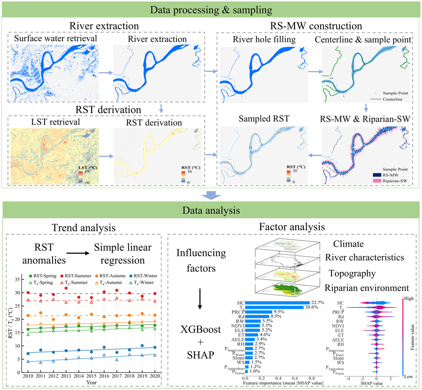
Workflow for river extraction, RST derivation, sampling, trend analysis and XGBoost-SHAP analysis.
Surface water was extracted using a combination of the modified normalized difference water index (NDWI) thresholding and Otsu’s method, and the JRC dataset. To create surface-water maps, monthly maximum composites were generated, and seasonal coverage was defined by a water occurrence threshold of ⩾ 50 % (Li et al., 2023). Rivers were then extracted within the surface-water mask. Water bodies < 0.0027 km2 (three pixels) were eliminated (Yang et al., 2020). Lakes, wetlands, reservoirs and dams were excluded using the Global Lakes and Wetlands Database (Lehner and Döll, 2004) and the Global Reservoir and Dam Database (Lehner et al., 2011). Residual ponds and rice paddies were eliminated through shape-index analysis in combination with manual visual interpretation. Finally, morphological closing and opening operations were carried out to further reduce noise and enhance river continuity (Yang, 2020), thus generating seasonal river maps. River extraction accuracy and completeness were validated by manual inspection against Google Earth imagery.
In RST retrieval, pixels affected by cloud cover, cloud shadow, and snow/ice were first removed using the QA_PIXEL quality assessment band from Landsat Collection 2. Missing pixels were then gap-filled and temporal noise reduced using linear interpolation combined with Savitzky-Golay filtering (Savitzky and Golay, 1964) after cloud masking. LST was subsequently retrieved with the statistical mono-window (SMW) algorithm (Ermida et al., 2020), which integrates Landsat TOA and SR data together with TCWV and ASTER-GED V3 datasets. Finally, seasonal LST composites were generated through temporal averaging and subsequently validated against GST data. Because RST was derived by extracting Landsat LST over river pixels, the validation of LST against ground observations provides an indirect assessment of RST accuracy in the absence of in-situ river temperature measurements. Specifically, seasonal mean GST recorded at each station was compared to the mean LST within a 3x3-pixel window centered on the respective station. Landsat-LST performance was evaluated using the Pearson correlation coefficient (r), and the Root Mean Square Error (RMSE) (Guillevic et al., 2018). Here, r quantifies the correlation between Landsat-LST and GST; RMSE measures the average magnitude of the discrepancy between Landsat LST and GST, with lower values indicating better agreement. After validation, seasonal RST (2010-2020) was derived by masking the LST raster with contemporaneous river raster in ArcGIS.
Temporal trend analysis of RST
Temporal trends in RST were analyzed following the approach from Intergovernmental Panel on Climate Change (IPCC, 2023). Analysis was conducted at basin and regional (YRD) scales to reveal macro-scale spatiotemporal evolution. Seasonal and annual mean RST values were first calculated for the YRD and each basin (2010-2020). Inter-annual RST anomalies were then determined relative to the 2010-2020 mean. Finally, a simple linear regression was fitted to each anomaly series, and trend significance was tested at p < 0.05. Positive slopes indicate warming, negative slopes cooling, and absolute slope values quantify rates of change.
Analysis of RST influencing factor
Sample construction
To analyze the factors influencing RST at the reach scale, an adaptive river-width-based sampling method, referred to as the River Surface Moving Window (RS-MW), was developed (Figure 3a). Initially, voids in the river raster (mainly representing in-stream islands) with areas ⩽ 9 km2 were filled to improve river continuity, and then the OpenCV library was used to skeletonize river centerlines. Tangent directions were calculated per pixel along the centerline using local average gradients, and normal directions were derived as perpendicular vectors. RW was calculated by measuring distances from the centerline to riverbanks along the normal vectors. Sample points were then generated at 1 km intervals along the centerline, defining rectangular RS-MW windows centered at these points. Each window features one side fixed at 360 m parallel to the tangent and another side equal to RW parallel to the normal (Figure 3a). RS-MWs with RW < 3 pixels were excluded to reduce the effect of near-bank reflected radiance and ensure sampling precision (Martí-Cardona et al., 2019). The retained RS-MWs serve as final sampling units.
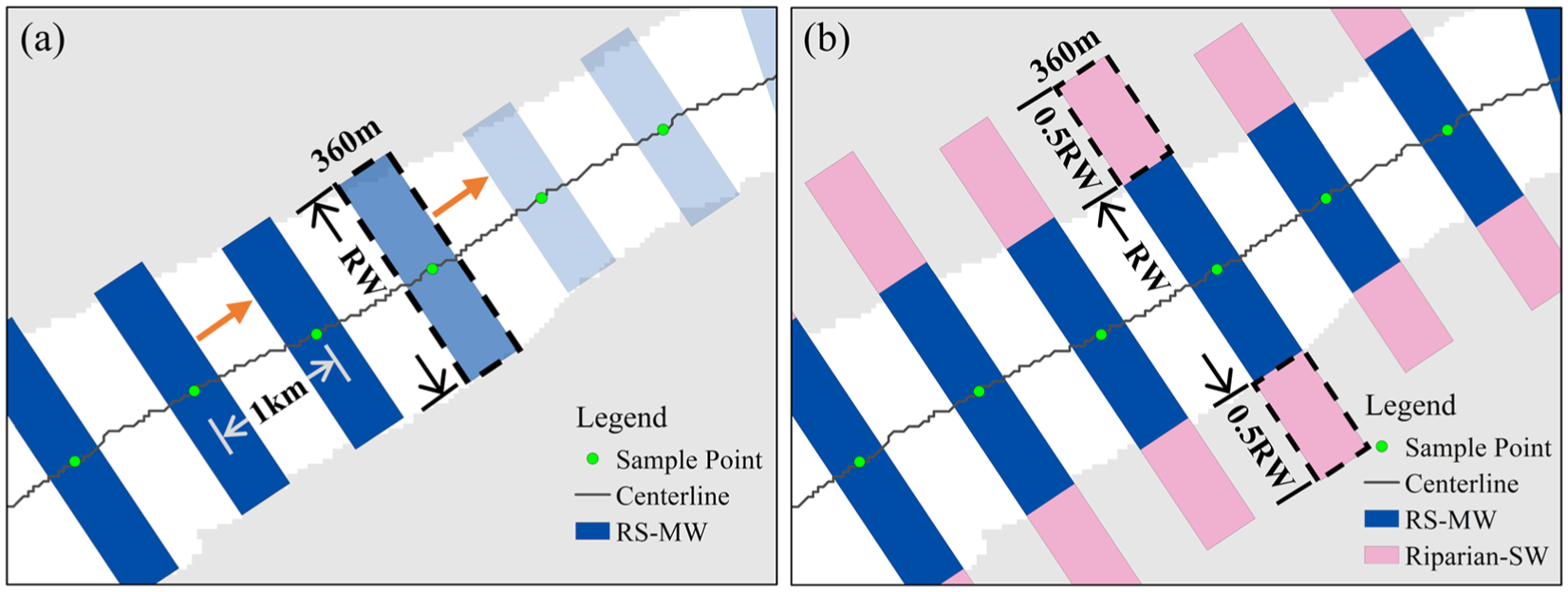
Schematic diagrams of analysis windows. (a) River Surface Moving Window (RS-MW) for RST sampling and calculation of factor values; dark-blue rectangles are processed RS-MWs, the dashed rectangle is the current window, and pale-blue rectangles are upcoming windows. (b) Riparian Sampling Window (Riparian-SW) to calculate the riparian-environmental factor values; pink rectangles denote the Riparian-SWs.
Considering the large number and considerable variation in scale of rivers in the YRD region, and based on evidence that near-stream conditions better predict river temperature (Chang and Psaris, 2013), an adaptive river-width-based method was developed to delineate riparian areas, thus defining the Riparian Sampling Window (Riparian-SW) (Figure 3b). Specifically, two rectangular windows were generated on each riverbank for every RS-MW, aligned with the RS-MW orientation. Each Riparian-SW window had one side fixed at 360 m parallel to the tangent and another side equal to 0.5 RW parallel to the normal (Figure 3b). Computational procedures were implemented in Python.
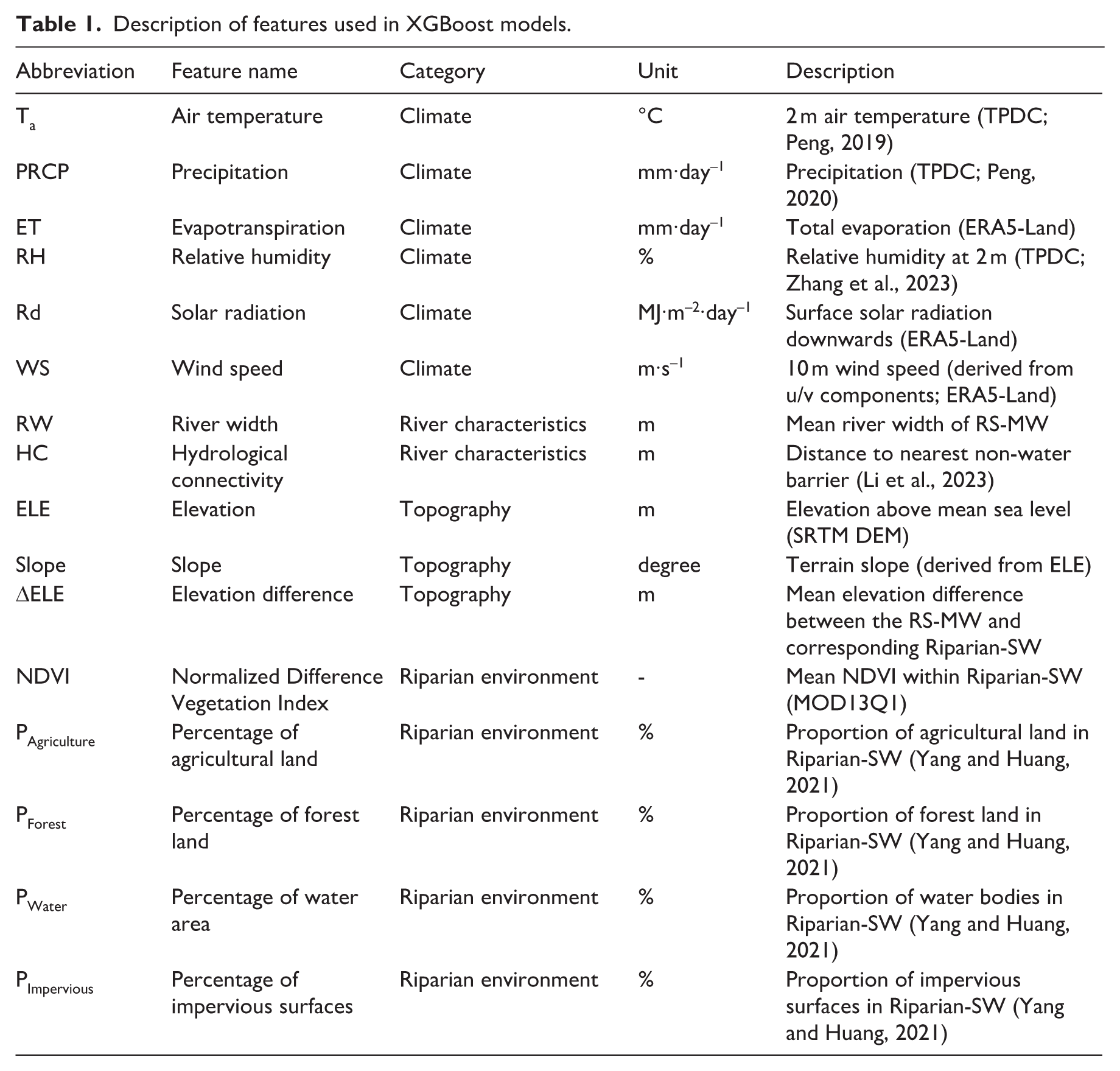
Based on the framework of river temperature drivers defined by Caissie (2006) and Wanders et al. (2019), and considering data availability, 16 potential influencing factors of RST were selected from four categories: climate, river characteristics, topography, and riparian environment (Table 1). Climatic factors comprise air temperature (Ta; °C), precipitation (PRCP; mm day−1), evapotranspiration (ET; mm day−1), relative humidity (RH; %), solar radiation (Rd; MJ m−2 day−1) and wind speed (WS; m s−1). There are two river-characteristic factors, viz. river width (RW; m) and hydrological connectivity (HC; m), while topographic factors include elevation (ELE; m), slope (Slope; °) and elevation difference (ΔELE; m). Riparian-environmental factors are comprised of the normalized difference vegetation index (NDVI), percentages of riparian agriculture (PAgriculture; %), forest (PForest; %), water (PWater; %) and impervious surfaces (PImpervious; %). RW, Slope, and ΔELE were calculated independently; RW was calculated as described above; Slope was derived from DEM using ArcGIS; ΔELE was defined as the difference between the mean elevations of RS-MW and the corresponding Riparian-SW. For each factor, seasonal values were calculated separately for each year from 2010 to 2020. Static variables (topographic factors: ELE, Slope, and ΔELE) retain their original values across all seasons; annual-resolution variables retain yearly values for all seasons within the corresponding year; the remaining variables were aggregated into seasonal means.
Description of features used in XGBoost models.
The XGBoost model was developed using RST as the primary response variable and 16 factors as input variables. For RST, mean values were calculated for river pixels within each RS-MW; for climatic, river-characteristic and topographic factors, mean values were calculated within RS-MWs; for riparian-environmental factors, however, their mean values were specifically calculated from non-river pixels within the corresponding Riparian-SWs.
XGBoost model construction and SHAP interpretation
Prior to model construction, observations with missing values were first removed. Multicollinearity among the explanatory variables was then assessed using variance inflation factor (VIF) analysis based on the sampled dataset, and no severe multicollinearity was detected (VIF < 5). Seasonal XGBoost models were subsequently constructed using approximately 70,000-80,000 samples for each season. Bayesian optimization tuned hyper-parameters include maximum tree depth (max_depth), learning rate (learning_rate), number of trees (n_estimators), subsample ratio (subsample), column-sampling ratio (colsample_bytree) and regularisation parameters (reg_lambda, reg_alpha). This method efficiently identifies global optima in complex, high-dimensional spaces (Zhao et al., 2022). Data were split into training (80%) and testing (20%) subsets, and five-fold cross-validation was performed. Model accuracy was evaluated using R2, mean absolute error (MAE) and root-mean-squared error (RMSE).
SHAP was used to assess each feature’s influence on RST predictions. At the global level, SHAP bar plots were generated using mean absolute SHAP values to rank feature importance, and SHAP beeswarm plots illustrate effect directions. At the feature level, SHAP dependence plots show how RST predictions respond to variations in individual features, and SHAP dependence plots with interaction coloring reveal pairwise dependencies based on SHAP interaction values.
Results
Spatiotemporal characteristics of RST
RST in the YRD exhibits distinct seasonal variability, peaking in summer, reaching a minimum in winter, and showing intermediate values in spring and autumn. Autumn temperatures are slightly higher than those in spring (Figure 4a). Long-term trend analysis (2010-2020) evidences significant increases in both RST and Ta during spring (RST: 0.15 °C yr−1, Ta: 0.18 °C yr−1; p < 0.05) and winter (RST: 0.19 °C yr−1, Ta: 0.27 °C yr−1; p < 0.05). In autumn, RST change is small (0.03 °C yr−1, p ⩾ 0.05), whereas Ta increases significantly (0.13 °C yr−1, p < 0.05). In summer, considerable interannual fluctuations in RST are observed, while neither RST nor Ta show significant trends (RST: -0.01 °C yr−1; Ta: 0.03 °C yr−1; p ⩾ 0.05). Overall, the rate of RST change over time is consistently lower than that of Ta (Figure 4a and c).
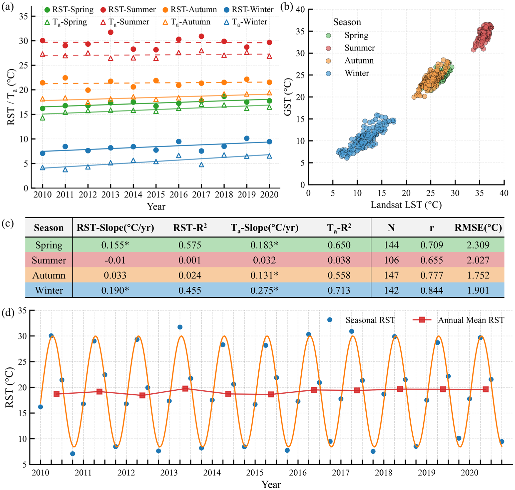
Validation and temporal characteristics of RST in the YRD, 2010–2020. (a) Interannual trends of seasonal RST (dots) and Ta (triangles); solid lines denote significant trends (p < 0.05), dashed lines are non-significant. (b) Validation of Landsat-derived LST against GST (2018–2020). (c) Slope and R2 for RST and Ta trends (asterisks indicate p < 0.05); summary statistics: N, r, and RMSE for LST-GST validation. (d) Seasonal RST (blue circles) with fitted sine curve (orange) and annual mean RST (red squares).
The long-term (2010-2020) annual mean RST is 19.19 °C, with long-term seasonal means of 17.30 °C (spring), 29.64 °C (summer), 21.41 °C (autumn) and 8.42 °C (winter) (Online Supplementary Table S3). The seasonal RST time series fits well to a sine function (R2 = 0.988, RMSE = 0.84 °C, MAE = 0.68 °C), demonstrating pronounced periodicity. Interannual analysis reveals a significant RST increase of 0.092 °C yr−1 (R2 = 0.39, p < 0.05), amounting to an approximate 0.92 °C rise over the decade (Figure 4d).
At the basin scale, seasonal RST varies across all basins, with notable spatial differences in long-term means (2010-2020) and temporal trends (Table 2). In spring and summer, the highest RST evidently occurred in the Eastern Zhejiang Rivers Basin, whereas the Lower Yangtze River Basin recorded the lowest, indicating marked spatial heterogeneity. In autumn and winter, RST exhibits a latitudinal decline, with a steeper gradient in winter. A temperature contrast of 6.3 °C is observed between the northernmost Yishusi River Basin (5.39 °C) and the southernmost Southern Zhejiang Rivers Basin (11.74 °C). Annual mean RST shows similar inter-basin differences to spring and summer, and latitudinal gradients akin to autumn and winter, highlighting a dominant latitudinal pattern alongside spatial heterogeneity.
Seasonal and annual RST means and trends (2010-2020) in eight basins.
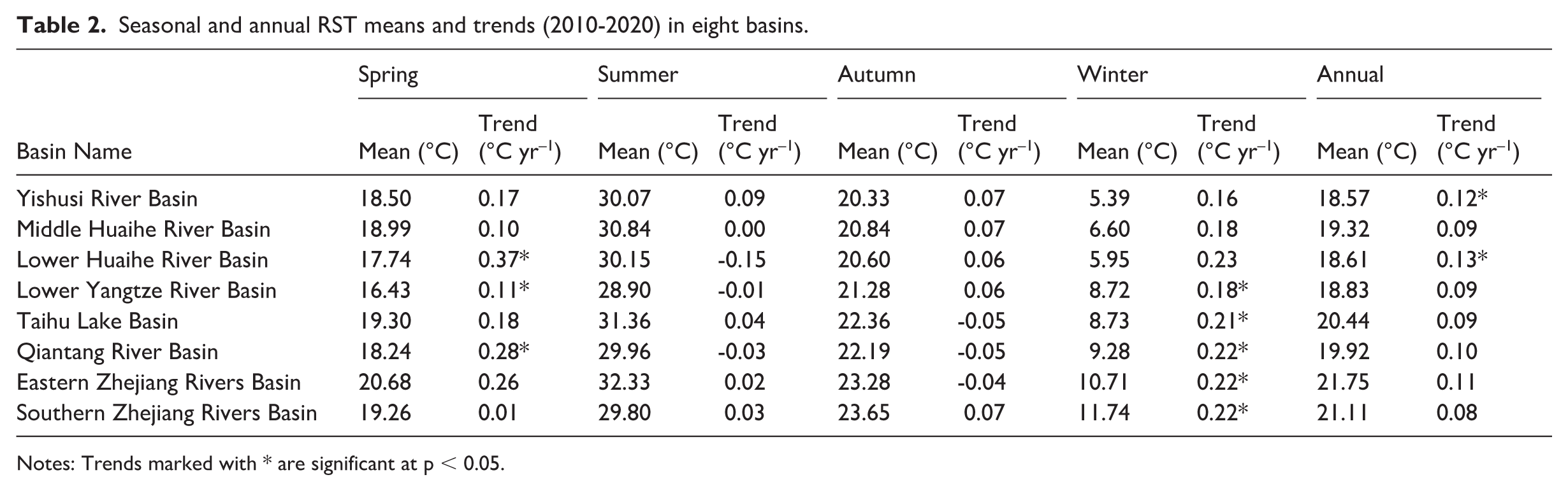
Notes: Trends marked with * are significant at p < 0.05.
Interannual RST trends also differ among basins (Table 2). All basins exhibit a warming trend in spring, winter, and at the annual scale, and winter warming rates increasing southwards. In summer and autumn, slight but non-significant cooling is evident in some basins (p > 0.05), mainly in the northern regions (e.g., Middle/Lower Huaihe River Basin) during summer and southern basins (e.g., Eastern Zhejiang Rivers Basin) during autumn.
The reliability of the Landsat-derived RST was assessed by comparing seasonal mean LST with GST at meteorological stations during 2018-2020. The correlation coefficient (r) ranges from 0.655 to 0.844 (p < 0.001), and RMSE varied between 1.752 and 2.309 °C. These results confirm that Landsat-LST effectively represents regional thermal variations and supports the suitability of the derived RST for subsequent analysis (Figure 4b and c).
Seasonal analysis of feature importance
All XGBoost models achieved high accuracy, with winter performing best (R2 = 0.924, RMSE = 0.700), followed by spring and autumn; summer exhibited relatively lower accuracy levels. The hyper-parameters and predictive performance for XGBoost models are summarized in Online Supplementary Table S4.
Mean absolute SHAP values and feature importance rankings for each season are illustrated in Figure 5A–D and detailed in Online Supplementary Table S5. During spring and summer, HC and Ta are shown to be the primary influential factors, with comparable SHAP values in spring (HC = 0.775; Ta = 0.702), but with HC being more important than Ta in summer (HC = 0.637; Ta = 0.439). Conversely, Ta is the predominant factor in autumn (0.828) and winter (1.400), registering considerably higher SHAP values compared to all other variables. The winter SHAP value for Ta is the highest observed across all seasons, emphasizing its paramount influence during colder seasons. To further examine the seasonal variability of HC, we compared its mean absolute SHAP values with the seasonal patterns of HC itself (Figure 6). The results show that the contribution of HC to RST prediction is high during spring, summer, and autumn, but declines markedly in winter, a pattern consistent with its seasonal dynamics within the YRD.
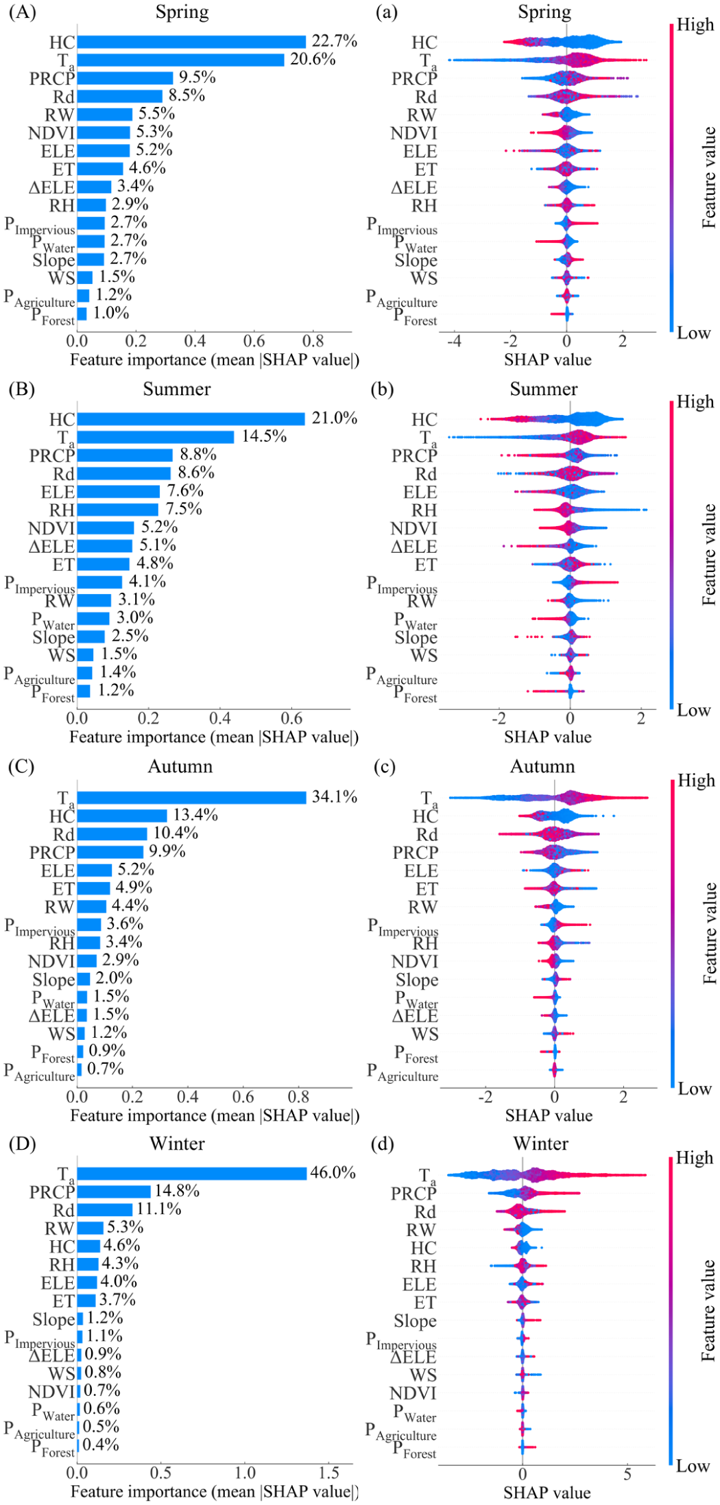
SHAP plots of XGBoost models. (A–D) show bar plots of feature-importance rankings, (a–d) show beeswarm plots illustrating the influence of each feature (SHAP > 0 = warming; SHAP < 0 = cooling; |SHAP| = effect magnitude). Point color represents the feature value (red = high, blue = low).
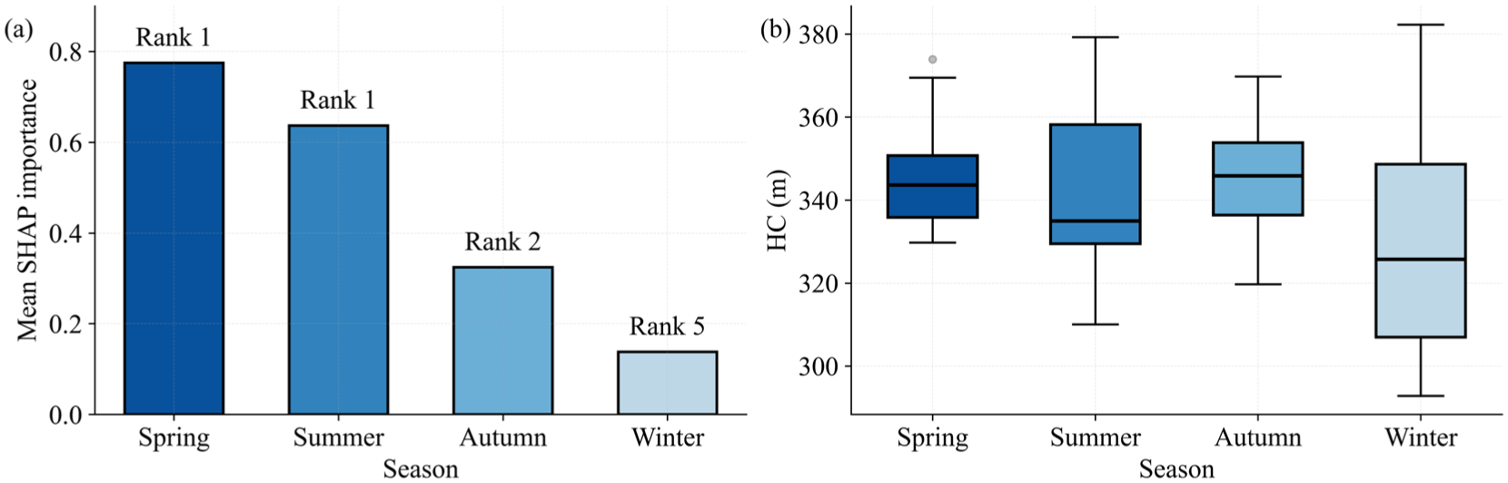
Seasonal variation in HC. (a) Mean SHAP importance of HC; numbers above bars denote HC rank among the 16 factors. (b) HC values (2010–2020).
PRCP and Rd demonstrate consistent importance year-round, evidenced by their SHAP values remaining between 0.2 and 0.5 (Table S5). During winter, Ta, PRCP, and Rd exhibit the greatest feature importance, underscoring the dominant role of climatic factors. Among the river-specific characteristics, RW also exhibits relatively high degrees of importance. For topographic factors, ELE is the most influential. Within riparian-environmental factors, NDVI and PImpervious are most influential, with the impact of NDVI notably more pronounced in spring and summer than in autumn and winter.
Overall, Ta and HC are the primary factors influencing RST across all seasons, although their relative importance has shifted over time. Ta and HC jointly dominate in spring and summer, with HC being slightly more influential than Ta in summer. In contrast, Ta is the predominant factor in autumn and winter. Among the four factor categories, climatic factors obtain the highest SHAP values, followed by river-characteristic factors. Topographic and riparian-environmental factors, however, are in general less influential (SHAP values < 0.2).
Direction, magnitude and interactions of influencing factors
The SHAP beeswarm plots clearly illustrate the direction and magnitude of factor effects on RST predictions (Figure 5a–d). Ta displays a bimodal pattern: high Ta is associated with warming effects, whereas low Ta exerts cooling effects. The widest SHAP range occurs in autumn and winter, indicating stronger warming effects of Ta under cold-season conditions. HC exhibits nonlinear responses, whereby strong connectivity is associated with cooling, but weaker connectivity shows more variable and inconsistent effects. Quantitatively, under conditions of high HC, the contribution to RST reaches approximately -1.57 °C in spring and -1.47 °C in summer, but shifts to -0.56 °C in autumn and -0.25 °C in winter, indicating that this cooling effect is substantially stronger in warm seasons and weaker in cold seasons.
There are marked seasonal differences evident in PRCP, where this parameter is linked to cooling in summer and autumn, but to warming in spring and winter. High Rd primarily has evident warming effects year-round, with occasional cooling under specific high-Rd conditions . High RW on the other hand consistently exhibits a cooling effect. ELE is primarily associated with cooling in spring and summer, yet warming in autumn and winter. NDVI consistently is associated with cooling effects, more strongly in spring and summer. PImpervious consistently exerts warming throughout the year.
Combinations of climatic factors (Ta, PRCP, Rd) exhibit the highest SHAP interaction strength in spring, autumn, and winter. In summer, however, the Rd-HC (0.088) and Ta-HC (0.083) interactions are more prominent, underscoring HC’s dominant role in RST during this season. Online Supplementary Table S6 lists the ten strongest feature pairs ranked by SHAP interaction strength for each season. Figure 7 shows SHAP interaction patterns for representative factor pairs. Among climatic factors, the Ta-Rd interaction is most significant in spring (0.132) and summer (0.096), and remains the second most influential in autumn and winter. At identical Ta levels, higher Rd samples yield larger Ta-SHAP values (Figure 7a–d), suggesting that Rd enhances Ta’s warming effect on RST. The Ta-PRCP interaction is dominant in autumn (0.124) and winter (0.161). In winter, higher PRCP levels are associated with lower Ta-SHAP values at the same Ta (Figure 7f), indicating that PRCP weakens Ta’s warming effect. Higher PRCP is linked to lower Rd-SHAP values at the same Rd in summer and autumn (Figure 7g and h), suggesting that PRCP reduces Rd’s warming influence.
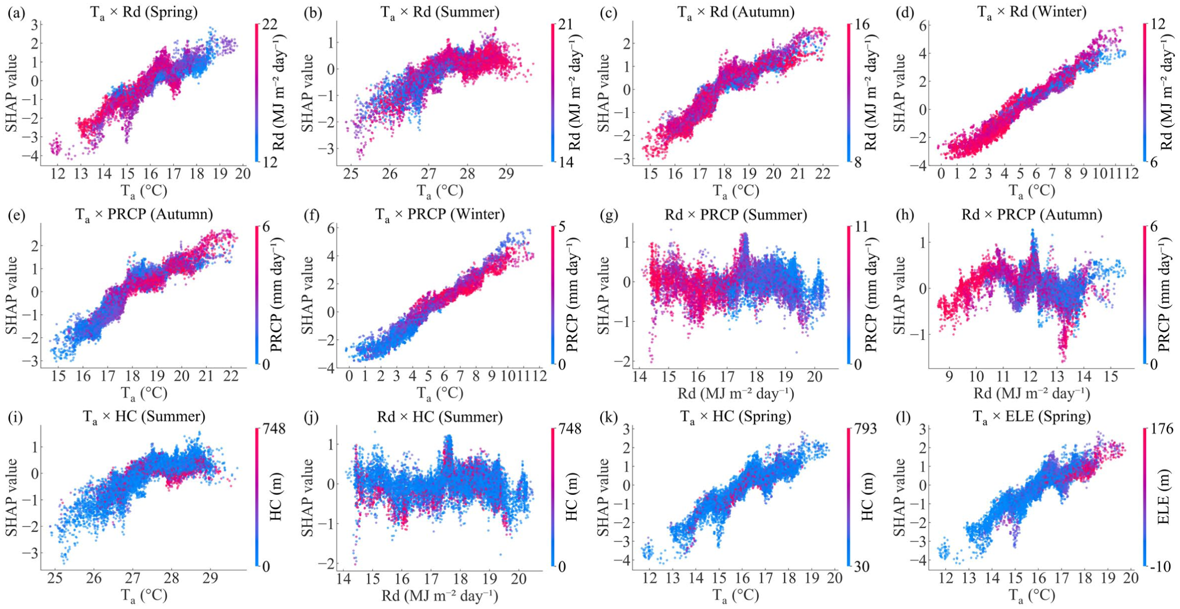
SHAP dependence plots with interaction coloring for key feature pairs. (a) Ta×Rd (Spring); (b) Ta×Rd (Summer); (c) Ta×Rd (Autumn); (d) Ta×Rd (Winter); (e) Ta×PRCP (Autumn); (f) Ta×PRCP (Winter); (g) Rd×PRCP (Summer); (h) Rd×PRCP (Autumn); (i) Ta×HC (Summer); (j) Rd×HC (Summer); (k) Ta×HC (Spring); (l) Ta×ELE (Spring). X-axis: primary feature value; Y-axis: SHAP interaction value; point color: secondary feature value (blue = low, red = high). Feature pairs were selected based on the highest absolute SHAP interaction values (see Online Supplementary Table S6).
An analysis of HC reveals that high-HC samples in spring and summer primarily exhibit lower Ta-SHAP and Rd-SHAP values (Figure 7i–k). These findings indicate that HC mitigates the warming effects of Ta and Rd, with the effect being more pronounced in summer (Online Supplementary Table S6). HC interactions appear to have no clear pattern in autumn and winter. Regarding ELE, high-ELE samples are linked to lower Ta-SHAP and Rd-SHAP values in all seasons except winter (e.g., Ta-ELE in spring; Figure 7l), suggesting that ELE moderates the warming effect of Ta and Rd. Finally, other pairs (ET-Rd, Ta-ET, Ta-RW) show lower interaction strength, yet they consistently rank among the top ten seasonal factors, thus indicating a secondary influence on RST.
Overall, the control of RST is fundamentally shaped by the independent effects of several factors. High Ta is the primary driver of warming, whereas high HC is the leading cooling effect. Other contributing factors include PRCP, Rd, ELE, NDVI, and PImpervious. Beyond these individual impacts, factor interactions further modulate the magnitude of individual effects. Climatic-factor combinations (Ta-PRCP-Rd) exhibit the most pronounced interactions, where high HC and ELE played a notable role in mitigating warming from high Ta and strong Rd during warm seasons. Therefore, RST variations arise from the combined independent and interactive effects of multiple factors, exhibiting distinct seasonal patterns.
Discussion
Air temperature-dominated mechanisms of RST variation
Under ongoing climate change, RST has emerged as a crucial indicator of regional ecological security and water resource management. In this study, RST represents the thermal state of the air-water interface, where energy exchange processes play a dominant role in the river heat balance. SHAP dependence plots (Figure 8a–d) show that the warming contribution of Ta increases with rising air temperature, consistent with previous findings that greater air temperature increments amplify river warming effects (Grey et al., 2023). Extensive evidence confirms that Ta strongly correlates with RST and acts as a central predictor in water temperature models (Graf, 2019). Mechanistically, climatic factors influence RST primarily via conductive heat exchange and additionally by modulating radiation, convection, and evaporation processes (Chapra, 1997).
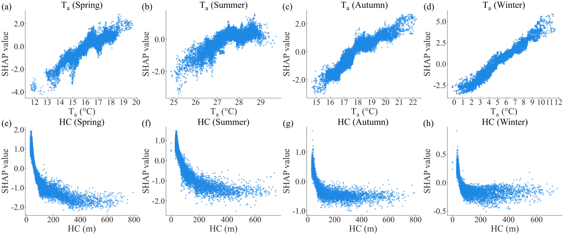
SHAP dependence plots of Ta and HC. (a–d) show Ta, and (e–h) show HC.
At the inter-annual scale, global warming has contributed to widespread increases in water temperature (Wanders et al., 2019). A significant warming trend in annual-mean RST is observed in the YRD (0.092 °C yr−1) (Figure 4d), with more pronounced warming in spring and winter. However, summer and autumn evidence no significant warming, and some basins even exhibit a slight cooling. This phenomenon may result from thermal-lag effects induced by hydraulic structures such as upstream dams and reservoirs (He et al., 2023); similar summer cooling phenomena have also been reported in other regions (Arismendi et al., 2012; Zhao et al., 2024). However, regardless of the annual average or seasonal variations, the observed rate of change in RST during 2010-2020 is consistently slower than that of Ta, confirming the ability of rivers to lag and buffer thermal changes (Gossiaux et al., 2019).
At the seasonal scale, there is a distinct thermal pattern in RST, with a near-sinusoidal pattern of variation. From spring to summer, rising Ta is shown to raise RST. However, despite Ta reaching its highest values in summer, its influence is mitigated as intensified evapotranspiration and solar radiation evidently counteract the warming effect. The weakening influence of Ta is evident not only in our reach-scale XGBoost analysis but also in the regional R2 values between RST and Ta, which are lower in spring and summer. This may be attributed to micro-scale processes, such as riverbed thermal buffering, having cumulative effects (Poole and Berman, 2001). Similarly, Wade et al. (2023) found that the importance of air temperature is relatively lower in summer, and river temperature is also influenced by hydrologic and watershed characteristics (Wade et al., 2023). From summer to autumn, the decline in RST is attenuated by heat accumulation in water bodies and a hysteresis effect, even as Ta decreases (Kim et al., 2021), resulting in higher RST in autumn than in spring. In winter, with solar radiation significantly reduced, RST primarily responds to Ta, which consequently emerges as the overwhelmingly dominant factor.
Significant interactions occur among Ta, Rd and PRCP. Rd directly supplies energy to river surfaces (Richardson et al., 2017), whereas PRCP modulates heat exchange depending on runoff intensity, duration, and flow paths (Leach et al., 2023), exerting a seasonal influence on RST. Simultaneous increases in solar radiation and air temperature synergistically enhance net heat flux, thereby accelerating river warming (Shinohara et al., 2021). In contrast, precipitation mitigates warming by promoting turbulent mixing and convective exchange, decreasing solar radiation through cloud cover, and absorbing latent heat via raindrop evaporation, thereby lowering net heat flux and moderating the effects of Ta and Rd (Tan et al., 2024).
In conclusion, Ta primarily governs RST seasonal cycles, interannual trends, and spatial distribution, while Rd and PRCP exhibit seasonally variable, bidirectional modulation effects. Significant interactions among these climatic factors underscore the dynamic coupling processes and synergistic regulatory mechanisms that shape the river thermal regimes.
Cooling role and seasonal modulation of hydrological connectivity
HC is another key determinant of RST, as it governs the spatial transfer of matter and energy among surface waters, including flow, transport, and redistribution processes (Liu et al., 2024). In this study, HC was quantified using morphological distance transformations. This structural connectivity index systematically characterizes the river’s physical properties such as boundaries, surface area, and spatial continuity. Furthermore, it serves as a proxy for hydrological responsiveness, water quality, and ecological health.
The SHAP analysis demonstrates that higher HC is generally associated with lower RST in all seasons (Figure 8e–h). Highly connected reaches with larger surface area and higher heat capacity exhibit stronger levels of thermal regulation (Webb et al., 2003). This enhanced connectivity promotes heat dispersion, mitigates local heat accumulation and improves the system’s ability to respond to hydrological disturbances. Additionally, high HC boosts water dilution and self-purification capacity, leading to increased transparency and improved water quality (Liu et al., 2022; Yu et al., 2015). This in turn reduces solar radiation absorption and promotes evaporative cooling, ultimately curbing the rise in RST.
Seasonal SHAP analysis suggests that the regulatory role of HC exhibits clear seasonal variability, remaining prominent during spring, summer, and autumn but declining sharply in winter. This seasonal pattern is consistent with the observed variability of hydrological connectivity across the YRD (Figure 6). Enhanced precipitation and discharge in warm seasons strengthen hydrological connectivity and water exchange, improving water quality, whereas winter low-flow conditions reduce connectivity and weaken the influence of HC. These results underscore that seasonal variation in HC may directly impact its ability to regulate the RST.
That HC substantially mitigated the warming effects of Ta and Rd on RST during the spring and summer seasons is revealed by the interaction analysis, with the most pronounced effect observed in summer. Previous studies have demonstrated that river sensitivity to air temperature is predominantly governed by river size and baseflow contribution (Kelleher et al., 2012). The HC index used here is capable of reflecting river size, and the SHAP results show robust interactions between HC and Ta, together providing strong support for the role of HC in climate regulation. No strong HC interactions are identified here for winter (Online Supplementary Table S6), likely attributable to reduced connectivity and diminished hydrological activity in this season.
Our findings indicate that high hydrological connectivity is generally associated with RST cooling across seasons, while its heat-buffering effects against high air temperatures and strong solar radiation are most pronounced during warm seasons, especially summer. Unfortunately, rapid urbanization and the proliferation of hydraulic structures (e.g. dams and weirs) have compromised natural connectivity (Johnson et al., 2024), which has diminished thermal regulation and increased vulnerability to extreme heat. Therefore, enhancing connectivity through artificial wetlands and ecological corridors (Préau et al., 2022) offers a key potential strategy to restore thermal regulation and ecological resilience of river systems, and support heat-risk management and adaptive decision-making.
Influence of other factors on RST
In addition to climatic factors and HC, other variables also notably influence RST. For example, riparian vegetation influences RST through shading, evaporative cooling, and localized climate modulation. The NDVI has significant cooling effects during the spring and summer seasons, although these effects diminish in the autumn and winter (Figure 5). This pattern reflects the strong seasonal control that vegetation exerts on thermal processes. The influence of riparian vegetation was also found to be contingent on river scale, riparian-zone structure, and species composition (Dugdale et al., 2024). These findings suggest that increasing riparian vegetation cover and strategically optimizing species and spatial allocations may bolster climate adaptability in river systems. In forested basins, wider rivers often lead to reduced shading and elevated river temperatures (Bartholow, 2000). However, in the highly urbanized YRD, where vegetation shading effects are inherently limited, larger RW consistently provide cooling throughout the year, likely due to greater heat capacity and enhanced evaporative cooling. Consequently, maintaining or extending wide river segments may be a key strategy for improving thermal resilience in urban river systems in particular (Jiang et al., 2021).
ELE exerts a cooling effect in spring and summer due to lapse rates and shading (Scott et al., 2002), but leads to warming in autumn and winter due to temperature inversions and heat retention. Changes in ΔELE enhance shading, thereby reducing heat input, particularly in summer (Figure 5b). Consequently, river reaches with high elevation and larger elevation differences exhibit enhanced thermal buffering during warm seasons.
Among land-use factors, PImpervious is a notable driver of RST warming (Figure 5), reflecting the thermal impacts of urbanization. Increased imperviousness reduces vegetation, elevates anthropogenic heat emissions, lowers surface albedo, raises near-surface air temperatures, and enhances the transfer of heat to rivers through runoff (Liu et al., 2020). Implementing urban planning, such as expanding green spaces and using permeable infrastructure, should assist in mitigating urban heat islands, lowering river temperatures, and improving the climate adaptability of urban river systems.
In summary, our reach-scale analysis reveals that, while Ta is the dominant determining factor overall, HC is more important during spring and summer, underscoring the critical role of river structural characteristics. This finding diverges from regional-scale studies that identify urban land use as the primary driver (Grey et al., 2023), as the PImpervious demonstrates lower importance at the micro-scale in our study. Despite our use of the best-performing near-bank buffers (Chang and Psaris, 2013), riparian-environmental factors consistently exert less influence compared to climatic and river-characteristic factors. The prominence of hydrological connectivity, along with our multi-scale comparisons, confirms the scale-specific nature of factors influencing RST (Dugdale et al., 2017). For effective reach-specific river temperature management, river characteristics such as hydrological connectivity may thus play a more crucial role. Consequently, integrated temperature regulation should consider scale-dependent processes to inform scientific management and guide adaptive policy development.
Limitations and future perspectives
This study proposed an adaptive RS-MW sampling method to ensure comprehensive coverage of river reaches and to effectively represent their thermal characteristics. The approach enables automated calculation of river width, excludes river segments narrower than three pixels to improve retrieval reliability, and supports large-scale analyses of RST drivers. However, the generalizability of the RS-MW framework beyond the current study area has not yet been evaluated and requires further testing across diverse climatic and geomorphological settings. Moreover, RS-MW sampling units are dynamically constructed along river networks, which limits the suitability for long-term tracking of identical river segments. Accordingly, the present analysis focuses on basin- and region-scale spatiotemporal patterns of RST rather than site-specific temporal trajectories.
Several sources of uncertainty should be acknowledged. First, the 16-day revisit interval of Landsat and the use of seasonal composites may smooth short-term thermal extremes. This limitation is more pronounced in summer, when cloud cover reduces the number of valid observations and increases uncertainty in seasonal RST estimates.
Second, uncertainties in sample representativeness arise from spatial resolution constraints and sampling design. To mitigate mixed-pixel effects and ambiguity in flow direction, river segments narrower than three pixels as well as confluence sections were excluded during sampling. While this strategy enhances data reliability, it inevitably limits the representation of small streams and headwater systems. Previous studies indicate that heat exchange in larger rivers is dominated by air-water surface processes, whereas in small or headwater streams, riparian shading, reduced wind exposure, and streambed or groundwater heat fluxes play a proportionally greater role (Caissie, 2006; Poole and Berman, 2000). Consequently, the exclusion of narrow streams may lead to an underestimation of the importance of riparian vegetation and subsurface processes, while potentially overemphasizing the roles of solar radiation and wind speed in regulating RST. Although river width was explicitly incorporated as an explanatory variable in the XGBoost model, the findings should primarily be interpreted as representative of medium-to-large river systems rather than headwater environments.
Third, due to data constraints, we did not incorporate factors such as water quality, hydrodynamic metrics, and anthropogenic influences (e.g., dams, wastewater discharge), although they may play critical roles in urban settings (Zhang and Chadwick, 2022). Finally, uncertainties also stem from model assumptions and interpretation. While SHAP analysis provides an interpretable framework for quantifying feature contributions, it reflects statistical associations rather than causal relationships. Processes not explicitly represented by the explanatory variables, such as hyporheic exchange or localized human heat inputs, may be partially absorbed by correlated predictors, introducing additional uncertainty.
Despite these limitations, our findings suggest that enhancing hydrological connectivity and ecological regulation may help mitigate RST risks during heat events. Recommended measures include restoring natural flow connectivity, reconnecting fragmented river networks, and removing redundant dams. Additional strategies involve managing riparian vegetation, increasing urban green spaces, optimizing shading, controlling anthropogenic heat emissions, and limiting the expansion of impervious surfaces. Integrating multi-source observations and modeling approaches will be essential for systematically evaluating the effectiveness of these measures under future climate scenarios.
Conclusion
This study developed a river-width-adaptive sampling method (RS-MW) and integrated it with the XGBoost-SHAP framework to derive and interpret reach-scale river surface temperature (RST) in the Yangtze River Delta (YRD). Results indicate significant RST warming over the past decade, particularly in spring and winter. Air temperature (Ta) is the primary driver of RST, while hydrological connectivity (HC) exerts a cooling effect that is substantially stronger in warm seasons. Riparian vegetation consistently contributes to cooling, whereas impervious surfaces intensify thermal stress.
These findings advance understanding of how climatic factors, river characteristics, topography, and riparian environments jointly regulate river thermal regimes in YRD. Importantly, the study highlights the critical role of hydrological connectivity in modulating spatial heterogeneity and seasonal RST patterns, providing guidance for targeted river management and climate-adaptation strategies. We recommend enhancing hydrological connectivity through measures such as wetland or pond construction and the expansion of blue-green infrastructure, conserving and restoring riparian vegetation. These targeted strategies can strengthen thermal regulation and bolster the resilience and adaptive capacity of river ecosystems under ongoing climate change.
Supplemental Material
sj-docx-1-tee-10.1177_2754124X261427548 – Supplemental material for Hydrological connectivity moderates seasonal river warming in the Yangtze River Delta: Evidence from a decade of Landsat observations
Supplemental material, sj-docx-1-tee-10.1177_2754124X261427548 for Hydrological connectivity moderates seasonal river warming in the Yangtze River Delta: Evidence from a decade of Landsat observations by Siyi Zhang, Fanhua Kong, Haiwei Yin, Zhenya Li and Michael E. Meadows in Transactions in Earth, Environment, and Sustainability
Footnotes
Funding
The authors disclosed receipt of the following financial support for the research, authorship, and/or publication of this article: This study is supported by the National Key R&D Program of China (No. 2024YFF1307104, 2022YFE1303102) and the Global Engagement for Strategic Partnership project of Nanjing University.
Declaration of conflicting interests
The authors declared no potential conflicts of interest with respect to the research, authorship, and/or publication of this article.
Data availability statement
Data will be made available on request.
Supplemental Material
Supplemental material for this article is available online.
Author biographies
References
Supplementary Material
Please find the following supplemental material available below.
For Open Access articles published under a Creative Commons License, all supplemental material carries the same license as the article it is associated with.
For non-Open Access articles published, all supplemental material carries a non-exclusive license, and permission requests for re-use of supplemental material or any part of supplemental material shall be sent directly to the copyright owner as specified in the copyright notice associated with the article.