
Abstract
Faced with a lack of flat land and economic transitions over the decades, Hong Kong Island has experienced six phases of land development, resulting in an extremely high-density urban form. In contrast to conventional urban morphology studies developed in European old towns that mainly focus on planar figure-ground configurations, this study attempts to adapt and contextualize morphological methods to analyze composite elements, spatial relations, and structures of volumetric high-density urban form in Wan Chai, Hong Kong, as shaped by socio-economic contexts from 1841 to 2022.
In Wan Chai, these six phases of development have given rise to four distinct morphogenetic regions, transitioning from the earliest irregular settlement on slope terrain, to colonial compact street blocks, and finally to a sparse multi-layered hub on reclaimed land. The study compares the transformations of four sites across six phases and proposes a volumetric structure as a framework for interpreting these sites. It further reveals that the evolution of street block patterns, the emergence of new elements, and alterations in spatial relationships in Wan Chai were driven by practical demands and constraints, such as terrain adapation, socio-economic shifts, transportation needs, and advancements in building technology.
By applying morphological methods to the high-density context, this research enhances the understanding of the formation and transformation of “segment-strip-like” urban patterns in Wan Chai. It provides a framework for interpreting volumetric urban forms, particularly in East and Southeast Asia. The findings have implications for urban design, emphasizing strategies for urban regeneration that address spatial connectivity, pedestrian life, and social adaptability at the street-to-plot level in high-density cities.
Keywords
Introduction: Exploring urban morphology in high-density contexts
Urban morphology, a key tradition in urban studies, focuses on methods for abstracting physical forms, analyzing spatial structures, and uncovering the socio-economic drivers of urban formation and transformation. Since the 1960s and 1970s, the field has been shaped by seminal works from Caniggia and Maffei (1979), Conzen (1960), Conzen and Whitehand (1981), and Moudon (1986, 1994), who established foundational methodologies for studying the transformation of urban form, primarily in low-rise, historically evolved cities. Although contemporary scholars have expanded these methodologies, research on the morphological evolution of high-density cities like Hong Kong remains limited.
Some studies have examined the urban form and development of Wan Chai, a high-density urban core area in Hong Kong, from perspectives such as land use regulations, real estate economics, and planning policy. However, few studies have applied an urban morphology approach to analyze the evolution of urban physical elements (such as buildings, streets, and plots), spatial relations, and their preservation over time in relation to socio-economic shifts in Wan Chai. This study addresses this research gap by adapting and contextualizing established urban morphology methods to high-rise, ultra-high-density urban forms (i.e., volumetric urban forms). Specifically, it explores the following two research questions:
How can traditional morphological methods be adapted forthe analysis of the unique volumetric urban patterns in Wan Chai, Hong Kong?
What transformations in physical elements, spatial relations, and hierarchical structures emerged within the complex urban fabric of Wan Chai across the six phases of its development?
Urban morphology plays a crucial role in guiding urban design and regeneration, ensuring alignment with hierarchical spatial structures and preservation principles to maintain continuity in the high-density urban context. By adapting and expanding existing urban morphology methodologies, this research deepens the understanding of volumetric urban patterns in East and Southeast Asian cities, advancing theoretical discourse in urban morphology and providing practical insights for urban design in high-density contexts.
Theoretical bases
Urban morphology traditions and implications for Wan Chai
Urban morphology examines the evolution of physical elements, spatial relations, and hierarchical structures under changing socio-economic contexts. Since the 18th century, European scholars have recognized the close relationship between urban landscapes, natural environments, social history, and human culture. In the 19th century, early geographical research on urban landscape and townscape emerged in German-speaking regions, laying the foundation for urban morphology research. By the 1960s and 1970s, key schools of urban morphology and building typology in Britain, Germany, and France developed foundational theoretical frameworks and methodologies for urban form analysis. This review distills core insights and methodologies from urban morphology and explores their applicability to the volumetric urban form of Wan Chai, Hong Kong.
The British school of urban morphology, pioneered by M. R. G. Conzen and later developed by scholars like Whitehand et al. (2009) and Birkhamshaw and Whitehand (2012), introduced foundational theories through a historico-geographical approach to settlement evolution. This school emphasizes how human adaptation to natural environments shapes townscapes and socio-economic patterns over time. Conzen (1960) categorized the townscape into three physical form complexes, namely town plan, land utilization pattern, and building fabric. Each reflects evolving spatial and socio-economic characteristics. The town plan was further layered into three spatial patterns, i.e., street pattern, plot pattern, and building pattern. Each comprised recurrent physical elements within a hierarchical structure of urban form. Conzen also identified three scales of a town, which include plan units, morphogenetic regions, and the town or district. A town evolves from small-scale ensembles of plan units to larger morphogenetic regions with geographical similarities, demonstrating how urban forms evolve by layering new and old elements.
The Italian school of building typology, founded by Saverio Muratori and Gianfranco Caniggia, is rooted in Italian philosophical and architectural traditions, addressing the cultural discontinuity in urban and architectural design. This school established a typological process methodology, focusing on the continuity of building types through formation and transformation over time (diachronic) and across different locations (diatopic). It advocates for urban planning as a collective understanding and spatial identity of urban form, in which typologies represent shared community images and serve as a foundational framework for design.
Caniggia and Maffei (1979) proposed type evolution principles, such as “successive doubling” law, where new types formed by replicating base modules. For example, a single-family row house type evolved into a multi-family in-line house to meet higher-density living demands, altering the relationship between inhabitants and the building. They also classified five hierarchical levels of urban form: building, aggregate, tissue, city, and region. Physical elements at each level aggregate to create a more complex composite at the next hierarchical level, maintaining a containment relationship across levels. For instance, a simple tissue consists of plot aggregates connected by routes. Larger-scale elements preserve their type integrity over time, maintaining continuity and relational coherence. This approach implicitly views the evolution of building typology as inherently tied to local cultural contexts, underscoring its significance in urban planning and design (Cataldi et al., 2002).
Anne Vernez Moudon (1986) integrated the British and Italian schools of urban morphology and proposed typo-morphological research in North America. She studied the physical transformations of form typologies over a century in the Alamo Square area of San Francisco. Moudon refined the five-scale hierarchical structure of urban form, i.e., inhabited rooms, individual buildings, blocks, circulation networks, and natural features or main streets. At each scale, recurrent physical elements follow organizational rules governing their shape, size, location, and spatial relationships with other elements, sustaining order and diversity in urban forms.
Moudon identified key principles of urban transformation, including the persistence of initial frameworks, the importance of incremental transformations, and the impact of lot size on urban form. Small lots promote diversity, pedestrian activity, and gradual renewal, whereas larger lots foster more anonymous urban forms and functional segregation, disrupting traditional connections between buildings, lots, and streets. Applying these principles in future urban development can help reestablish connections between people, buildings, and broader urban structures, supporting cultural and functional vitality while preventing social obsolescence.
Previous studies have provided structured, hierarchical frameworks for understanding the complex evolution of urban spaces. The historico-geographical and typological methods introduced by the British and Italian schools reveal how past urban forms persist and interact with newer developments, creating a layered urban form. This perspective is valuable for urban design and policy, assisting planners in ensuring that new developments respect historical contexts while meeting modern needs.
Although originally developed for historical European towns, these frameworks can be adapted to high-density, high-rise environments like Hong Kong, revealing the evolution of spatial and socio-economic characteristics across diverse settings. Applying Conzen’s approach, this study investigates three spatial patterns at the morphogenetic regions of Wan Chai, considering their historical and socio-economic contexts. The recurrent physical elements of each spatial pattern are identified in each morphogenetic region in high-density Wan Chai, showing the layered and complex composition of new and old forms in high-density Wan Chai.
By identifying foundational components of urban forms and their hierarchical relations, this study applies the Italian school and Moudon’s approaches to classify the hierarchical levels of urban forms and identify element types in Wan Chai, such as building, plot, and simple tissue. Through typological methods, this study explores how composite elements interact and contribute to the overall spatial organization and identity of Wan Chai, highlighting the significance of spatial relations in hierarchical structures in high-density contexts.
This historico-geographical and typo-morphological approach illuminates the ongoing transformation of Wan Chai, emphasizing the relationship between past and present conditions. It provides a framework for guiding sustainable urban regeneration by helping to identify and preserve basic elements within their historical context.
Habraken’s level theory in open building
Introduced in the 1960s, Habraken’s “levels” concept divides the built environment into subsystems organized by their duration of use and encompassing user collectives, physical systems, and territorial units (Figure 1). Kendall (2009) advocates a hierarchical understanding of the built environment, where buildings and spaces dynamically adapt within layered systems. These levels reflect relationships between people, space, and time, with each scale showing a unique preservation period and degree of transformation (Habraken, 1972). This study applies Habraken’s level theory to analyze spatial relationships and form transformations within the dense urban fabric of Wan Chai, Hong Kong.
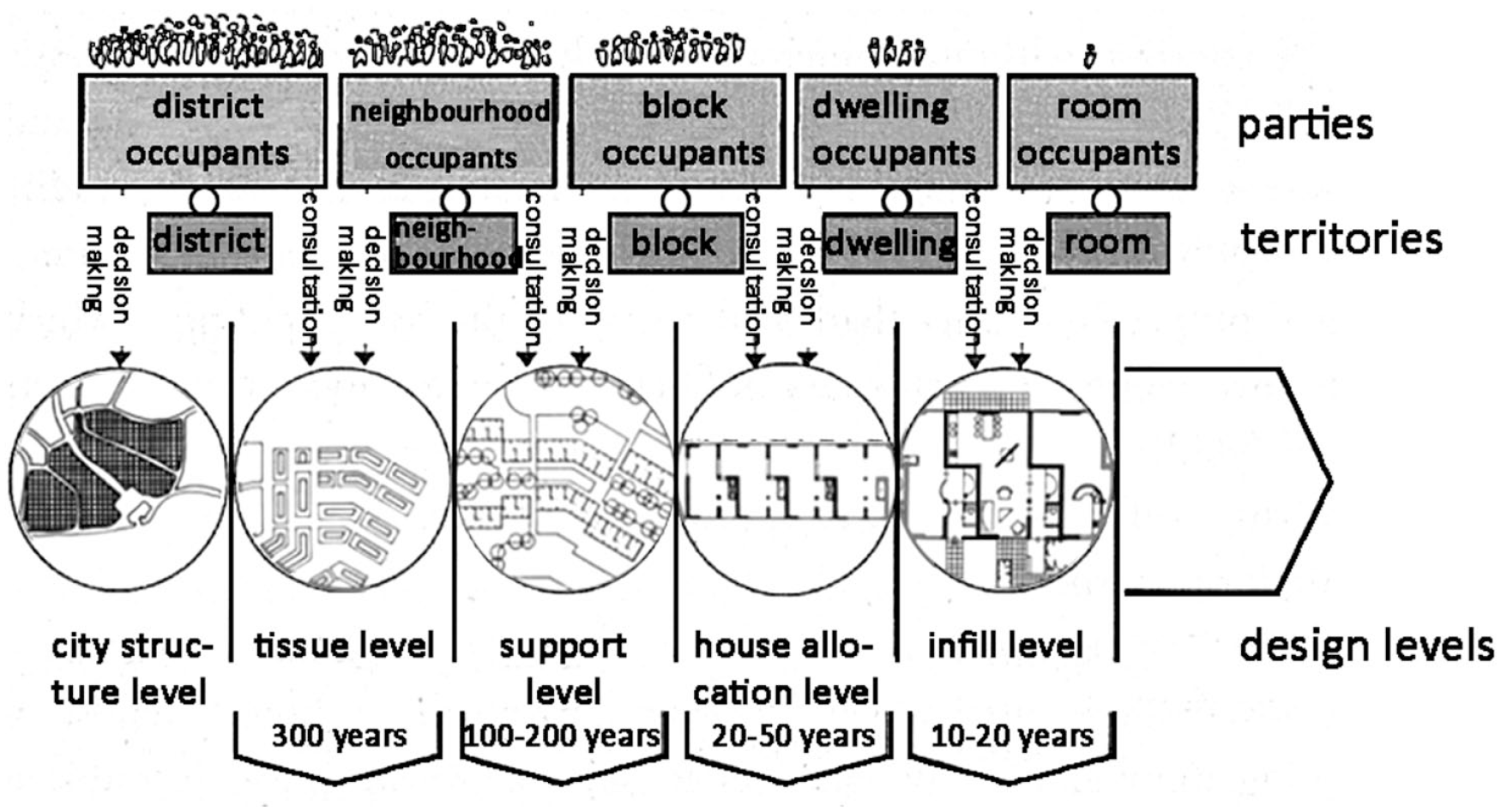
An illustration of Habraken’s “level” concept.
Habraken’s framework illustrates containment relationships across hierarchical levels, each associated with corresponding preservation durations for users, physical systems, and territorial units. Similarly, the urban morphology tradition, such as British and Italian schools, divided the urban system (referred to as the townscape and urban organism) as a hierarchy of levels. Each is defined by containment relationships and corresponding preserving durations. Expanding on this, Moudon (1986) restructured spatial levels to represent urban form in San Francisco, categorizing them into rooms, buildings, plot series, blocks, and circulation networks, each with varying preserving durations. Building on previous methodologies, Kropf (2014) proposed the concept of generic structure to further divide urban forms into physical and spatial elements at each level and clarified the containment relationship between levels. This study adopts and refines these level methods to analyze high-density urban form in Wan Chai, adapting Kropf’s (2014) hierarchy of spatial and physical elements to a volumetric structure to reveal both containment and access relations across levels.
A proposed framework for interpreting volumetric urban form in Wan Chai
Adaptation and contextualization of urban morphology traditions to Wan Chai
This study modifies urban morphology methods to contextualize them within the socio-economic, historical, and geographical context of Wan Chai, Hong Kong. It first identifies gaps and points of convergence in applying urban morphology theories to Wan Chai. Then relevant historical knowledge and indigenous urban form evidence are collected to refine traditional urban morphology methods, such as volumetric structure identification.
The British and Italian schools established methods for describing types of urban elements, hierarchical relations between elements, as well as the evolution of form types in spontaneous grown historical towns. Moudon (1986) innovatively adapted these methods to analyze the urban spatial structure and transformation of a colonial North American city. She developed new descriptions and frameworks to capture the unique urban form formation and transformation processes of San Francisco, which provided a valuable reference for adapting typo-morphological methods to decode Hong Kong. Unlike historical European towns, Hong Kong and San Francisco are colonial cities, which experienced less spontaneous urban growth from plots to aggregates and tissues, necessitating a different approach to urban form analysis.
In Moudon’s case, the concept of the block emerged as a newly defined element in the spatial structure, a condition analogous to Wan Chai. Blocks serve as key physical elements in the urban spatial hierarchy, replacing plot series and simple tissue in the conventional structures. In San Francisco, this shift can be attributed; to the initial grid surveying, which o established the street block grid at the outset of urban development. Similarly, in Wan Chai, the planned street block grid constituted the backbone of urban development from the establishment of city to subsequent land reclamation phases.
Both these colonial cities were surveyed and planned using a colonial grid system adapted to local topography. Bristow (1984: 27) refuted Tregear and Berry’s (1959: 8) claim of piecemeal growth of early Hong Kong without planning and argued that roads and land divisions were surveyed from the start of city development. Furthermore, the 19-century land-leasing system laid out street and block grids in a relatively rectangular form that resembled earlier colonial cities situated on flatter and more expansive terrain (Bristow, 1984: 27). Like San Francisco, the relatively regular block and street patterns of Wan Chai were established by systematic surveying rather than spontaneous, piecemeal growth.
However, there is a need to adapt and contextualize conventional urban morphology methodologies to Hong Kong and other East and Southeast Asian cities, considering their distinct socio-cultural, historical, and geographical contexts. Conzen, Cannigia, Muratori, and Moudon primarily analyzed lower-density, lower-rise urban forms in Europe and North America. Their methods require modification to address the complexities of high-density high-rise settlements within colonial and modernist-style street blocks prevalent in East and Southeast Asia.
Efforts to adapt conventional urban morphology methodology to Chinese cities such as Guangzhou, Suzhou, and Nanjing have been made since the 2010s. Whitehand et al. (2011) utilized Conzenian urban morphology methods to study Guangzhou. They found that these approaches effectively analyze urban fabric with a spatial hierarchy of orders, which solved the urban fabric removal problem in urban conservation planning. Chen and Romice (2009) applied the typology and morphology (typo-morphology) methods to analyze the historical transformation of urban blocks, plots, and building forms in Suzhou, China, for the purpose of examining the local cultural identity and inspiring the current urban design. These studies have demonstrated that urban morphology and typology methods rooted in the European and American cultural and geographical contexts can be adapted to analyze urban form generation and transformation in Asian cities and provide locally grounded urban design and conservation strategies.
Moreover, few morphological studies have investigated the basic components and hierarchical spatial structure of the volumetric urban form. Fujimori (2015) studied the typological process of housing projects in high-density and volumetric central Hong Kong. His study explored the role of government regulations and planning policies in shaping urban form transformation over time. However, while he studied the typological process of building types in volumetric urban forms, his study did not fully clarify the physical and spatial elements or hierarchical structures of volumetric urban fabric. Additionally, it lacked a comprehensive analysis of the differences in urban forms and form-economic processes unique to the region. This study aims to adapt approaches of urban morphology to address the gap of volumetric structure analysis in Hong Kong. Beyond enhancing the applicabillity of urban morphology studies in an Asian context, it also broadens the theoretical scope of the field.
Volumetric structure
This study proposes the concept of volumetric structure as an analytical tool for the description of physical and spatial elements organized by hierarchical relations in the multi-layered urban form of high-rise high-density areas. It serves as the foundation of the proposed methodological framework. The volumetric structure further integrates the understanding of physical form and compositional hierarchy as explored by Conzen, Caniggia and Maffei, and Moudon. This tool is designed to decode the elements, relations, and spatial hierarchy of volumetric urban forms.
A comparative analysis of volumetric structures at the neighborhood level is conducted for four sites in the contemporary phase of Wan Chai, by means of illustration and descriptive methods. This comparison of volumetric structures across adjacent areas aims to identify the key diatopic variances and morphological consistencies among four sites. Additionally, the proposed methods can be used to analyze characteristics of volume structures in older urban forms from different historical periods. By comparing characteristics of volumetric structures at each phase at the same site, this study demonstrates the progressive growth of urban form from past to present in Wan Chai.
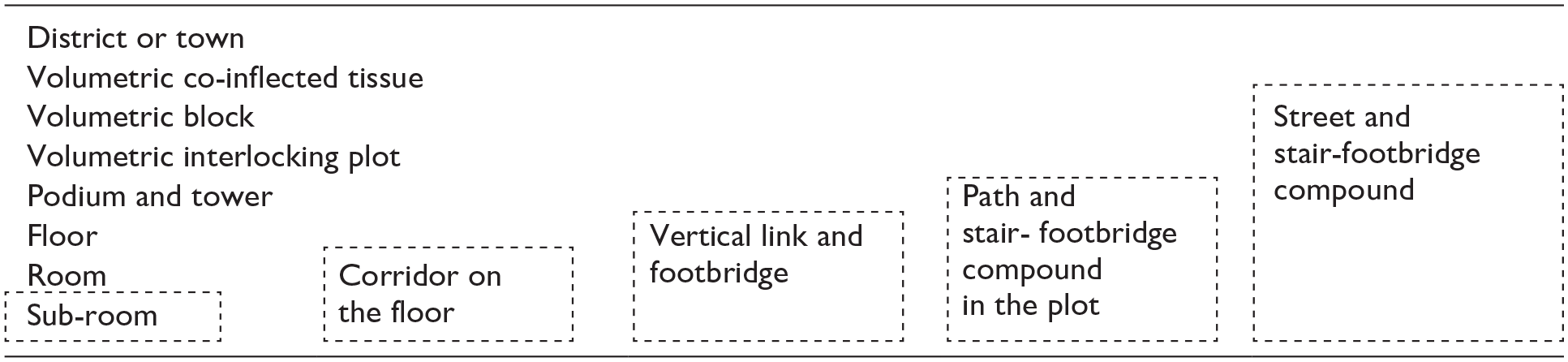
The multi-level diagram
The volumetric structure is initially represented through a multi-level diagram, which illustrates the containment hierarchy between elements and expresses the overall structure of urban form. This method builds on Kropf’s (2014) generic structure. Two types of volumetric multi-level diagrams with symbolic notations are created. The upper diagram represents a traditional gridiron street block pattern in a historical volumetric urban area (Table 1), while the lower diagram depicts a newly planned urban tissue in an adjacent modernist-style volumetric urban area (Table 2).
Multi-level diagram of the spatial structure for the traditional high-density urban form (e.g., Wan Chai).
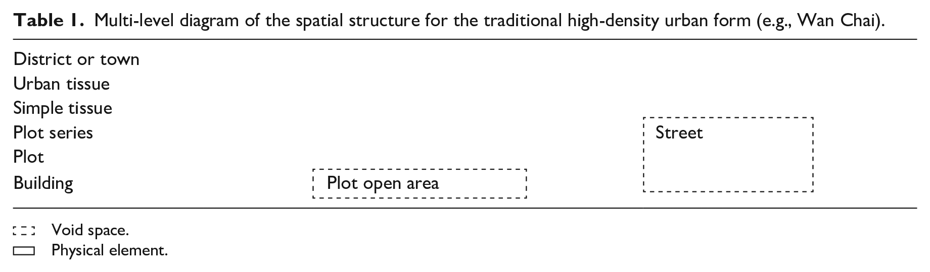
 Void space.
 Physical element.
Multi-level diagram of the volumetric structure for the contemporary high-rise, high-density urban form (e.g., Wan Chai).
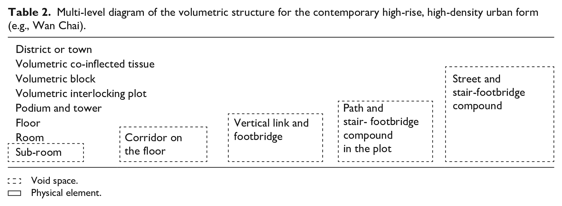
Void space.
Physical element.
Access relations between hierarchical levels
The volumetric structure is a hierarchy composed of multiple levels of physical and spatial elements. In the multi-level diagram, each row represents a distinct level of elements in the hierarchy (Figure 2). The black boundary that encloses elements represents the relation between different hierarchical levels (Figure 2). The volumetric structure incorporates access relations among physical and spatial elements in the built environment, as discussed in Marshall’s (2015) study.
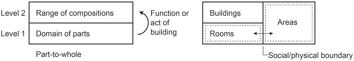
Relations between levels and elements in a generic structure.
The access relation typically defines the access order from the higher-level void space to the lower-level void space in a spatial hierarchy. In this study, access relations extend further to describe the hierarchical connections between void spatial and solid physical elements through the access order. To be specific, access relations encompass two types of interface transitions. The first is incursive access, where transitions occur from a continuous void space to an immediate physical entity. The second is networked access, which connects a higher-level void space to a lower-level one through a spatial network. Based on this definition, the access relation of volumetric structures indicates two aspects. Firstly, it incorporates the incursive access order. People transit from void spaces to physical entities at an adjoining level, i.e., from the right to left column in the diagram. Secondly, it means the networked access order. People transit from larger-scale void spaces to smaller-scale ones, i.e., from the top to bottom row circled by dash line in the diagram (Tables 1 and 2).
Site selection criteria
Based on the Conzenian concept of morphogenetic region, this study divides Wan Chai into four sites. Hong Kong did not have a functional zoning plan from its initial development until 1957. The four morphogenetic regions of Wan Chai are delimited not by function zones but by stages of land reclamation. Each morphogenetic region is characterized by homogeneous urban components, spatial structures, and building types and is defined as a site. While each phase of reclamation generated distinct morphological components and varied spatial structures in the site, these forms were integrated in a larger-scale spatial framework, resulting in a highly mixed land use distribution across different sites. The four Sites 1 to 4 of Wan Chai are shown in Figure 3.
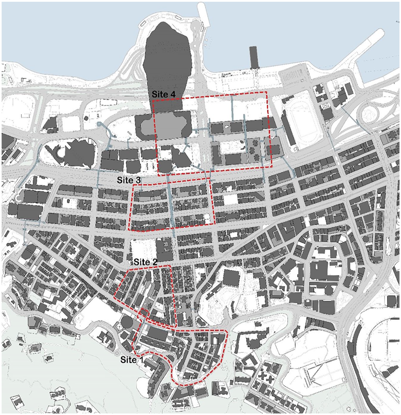
An illustration of urban patterns in four selected sites of Wan Chai (drawn by the author).
Four sites in Wan Chai are selected for the case study, which can be categorized into two types (Figure 3). The first type, Sites 1 to 3, are old colonial tissues featuring mixed-use commercial and residential building complex on the slopes and reclaimed land in Wan Chai South and Middle. The rationale for selecting these sites is their historical significance and complex morphological evolution. As early residential and retail areas in Hong Kong, they have undergone extensive morphological growth across different economic ideologies and possess historical significance, providing evidence of high-density developments in Wan Chai. Moreover, their socio-formal processes following land reclamation are unique to coastal cities.
The second type, Site 4, is a modernist commercial and institutional hub in Wan Chai North, situated on recently reclaimed land. This area features large, interconnected buildings linked by footbridges. This site was selected because it represents the emergence of an interiorized, multi-layered public pedestrian network in Hong Kong. Influenced by the Modernism Movement ideology, the northern tissue developed a different urban pattern from earlier urban fabrics. The first multi-layered pedestrian walkway system, diverting movement in a three-dimensional direction, appeared here. These spaces are characterized as interiorized, privately owned yet publicly accessible semi-public space. Halls and corridors in podiums and underneath metro station function as urban plaza and street, serving as key nodes in the walkway network. They facilitate pedestrian movements while also providing space for social life and daily activities. Open 24 hours per day, these spaces offer air-conditioned and well-lit environment free from automobiles and adverse weather conditions. Thus, the selection of sites, i.e., traditional colonial urban tissues (Sites 1–3) and modernist volumetric structures (Site 4), enables a comparative study of their formation and transformation principles.
Urbanization overview of Wan Chai
Wan Chai has undergone six phases of land reclamation, forming a progressive transformation that integrates fragmented urban form into a unified framework. Each phase generated new spatial forms that gradually extended from or overlaid onto original urban patterns, while simultaneously retaining residual morphological components and spatial relations inherited from previous phases and adjacent sites.
First, each reclamation phase extends from the previous one by introducing new spatial elements and structures, forming distinct morphogenetic regions in Wan Chai. Built upon the existing main street axis, these new spatial elements emerged to accommodate evolving social and economic demands, incorporate advanced technologies, and align with prevailing planning ideologies. For example, the late phases were influenced by advanced technology and planning ideology such as the Modernism Movement, resulting in large-scale street grids, mega-building structures, and increasingly complicated access relations in the spatial structure. Second, later phases retain remnant elements and existing structures, sustaining continuity across transformations. The persistence of the colonial street grid framework unifies the basic structure of each phase. Moreover, fundamental access relations among streets, blocks, plots, and buildings integrated different sites as a coherent form. Third, each phase experienced critical evolution, responding to socio-economic needs. Urban regeneration projects, such as large-scale real estate developments that merged traditional street blocks and plots, altered original access relations and intensified spatial complexity. While the urban patterns of the six reclamation stages formed different spatial structures, they collectively composed an integrated urban fabric in Wan Chai.
Phase 1 (1842–1856): Original topography
In the earliest years following the cession of Hong Kong to Britain, land development of Wan Chai was confined to its natural coastline and southern hills. The construction of the 15 m-wide Queen’s Road in May 1841 established the first major thoroughfare through Wan Chai, around which semi-planned land subdivisions emerged (Figures 4 and 5). In June 1841, the first land sale in Wan Chai by the Colonial Government for trade and residential uses took place (Bristow, 1984). Land parcels were surveyed and organized into a rough grid pattern by the colonial government land survey committee, forming the southern traditional urban tissue of Site 1. Besides this, the vertical links, such as external ladder lanes and ramps in the southern tissue, clearly demonstrate the adaptation and occupation processes in the mountainous geomorphology. The colonial government adopted a laissez-faire policy for land development. A number of plots around piers were sold to the marine shipping company for storage and warehouse land use by the colonial government.
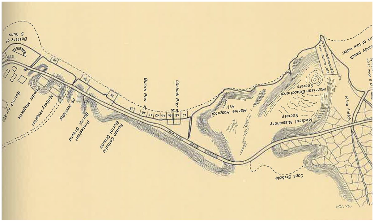
Old topological map of Wan Chai in 1842.
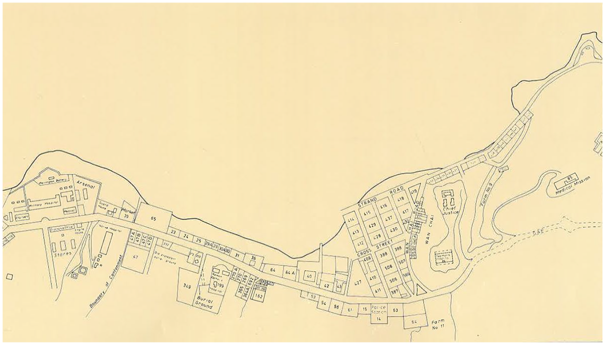
Old topological map of Wan Chai in 1856.
Phase 2 (1857–1922): First reclamation
The initial land reclamation between 1857 and 1859 extended the coastline of Wan Chai, creating Site 2 (Figure 6). A north–south (N-S) street grid was implemented, with streets perpendicular to the new shoreline, facilitating direct access to piers and enhancing the efficiency of shipping industry. The new major road, Johnston Road, was constructed along the coastline. After an intensive land development, Site 2 reached saturation by the 1900s. Building type in this era was characterized by the three- to four-story tenements along main roads and one-floor residential buildings near the southern hills, reflecting residential expansion in the area (Figure 7). The shipping industry and entrepôt port economy boomed during this period.
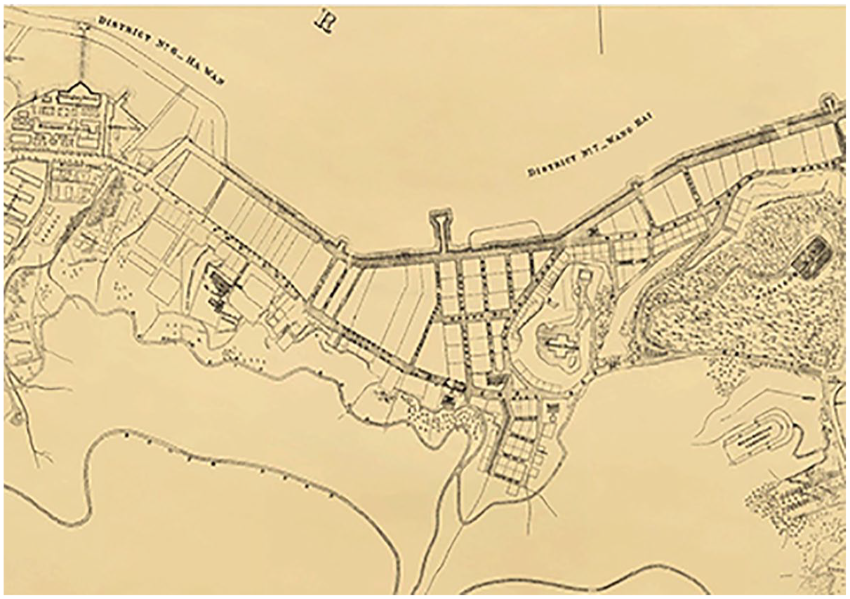
Old topological map of Wan Chai in 1889.
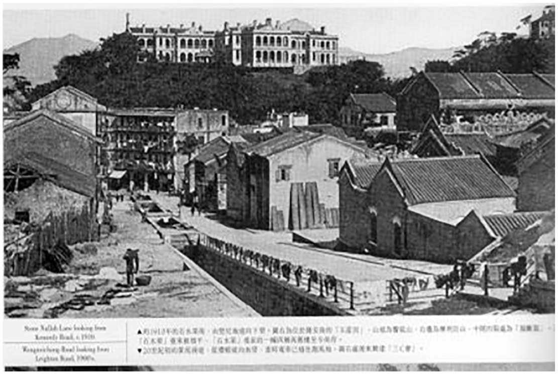
Tenement buildings at the Stone Nullah Lane in 1910.
Phase 3 (1923–1967): Second reclamation
The second reclamation, planned as the Wan Chai Reclamation Scheme and completed between 1923 and 1934, introduced Site 3, with an east–west (E–W) street orientation (Figure 8). This E–W layout improved transportation efficiency across the Hong Kong Island. The primary Gloucester Road was constructed with a width of 15 m for both pedestrians and various types of vehicles at this time. During this period, the economy shifted from an entrepôt port as a trade hub (1860s–early 1950s) to a manufacturing industrial boom (early 1950s–1970s). Based on this shift, the commercial ferry piers and the N–S streets linking the piers were successively reduced. The period continued the low-rise and compact residential development, with three- to five-story tenement buildings (Figure 9). After World War II, the emergence of entertainment venues catering to military personnel marked a shift in land use along Lockhart Road.
Old aerial photos of Wan Chai in 1934 (Source: Hong Kong Map Service 2.0, 2023).
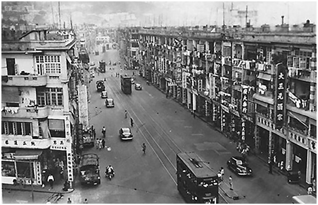
Hennessy Road in 1951 (Source: Taken by Moddesy downloaded from Gwulo).
Phase 4 (1968–1993): Third reclamation
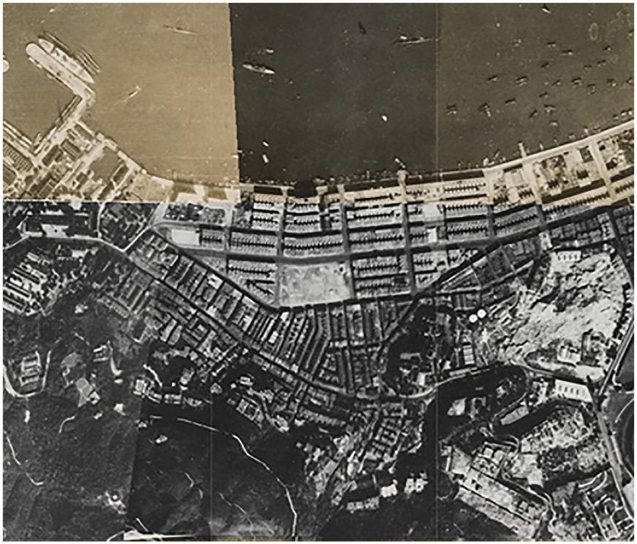
The third reclamation, from 1968 to 1972, formed Site 4 under the Praya East Reclamation Scheme. Influenced by modernist planning principles, particularly vehicle-oriented ideologies, this phase introduced sparse street grid with larger street blocks and wider roads, such as the expanded 40 m-width, eight-lane Gloucester Road (Figures 10 and 11). Public transport hubs, including MTR stations and bus stops, became concentrated along major routes like Hennessy Road. The building typology evolved into standalone, large-scale bulks with greater spatial intervals, some even occupying entire blocks. This transformation resulted in looser relations between streets, plots, in contrast to the more defined and cohesive urban fabric of earlier phases.
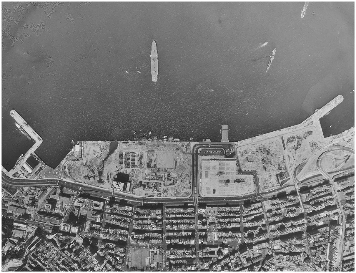
Old aerial photos of Site 4 South in Wan Chai in 1972 (Source: HKMS2.0, 2023).

Old aerial photos of Site 4 South in Wan Chai in 1982 (Source: HKMS2.0, 2023).
The commencement of MTR construction in 1975, along with the wealth accumulated during the manufacturing boom from the 1950s to the early 1970s in Hong Kong, spurred large land redevelopment activities in Wan Chai. Some local real estate developers grew stronger and had the capability to develop large commercial buildings on big land parcels. As a result, small plots and old tenement buildings were replaced by the big aggregated plots and high-rise and big office and commercial complexes. As developers sought more affordable land compared to Central, Site 4 was finally transferred into a new CBD extended from Central. This transition from predominantly residential to mixed-use, with office and commercial buildings, reflected the economic shift of Hong Kong from manufacturing to a service-based economy (1985–present).
Phase 5 (1994–2008): Fourth reclamation
The fourth reclamation, named Wan Chai Development Phase I, conducted between 1994 and 1997, served for the construction of the second phase of the Hong Kong Convention and Exhibition Centre (HKCEC) (Figure 12). This development did not establish a new urban pattern but added a significant institutional landmark to Wan Chai northern shore, emphasizing the role of the area in international trade and exhibitions and reflecting the image of Hong Kong as an economic service-based metropolis.
Old aerial photos of Site 4 North in Wan Chai in 1998 (Source: HKMS2.0, 2023).
Phase 6 (2009 to present): Fifth reclamation
The fifth reclamation, named the Wan Chai Development Phase II Project (2009 to 2018), focused on infrastructure improvements instead of the formation of new urban patterns, including the construction of underground utilities, public facilities, and government buildings. Projects include the new Wan Chai Ferry Pier and sections of the Central–Wan Chai Bypass, enhancing connectivity and public services without significantly altering the existing urban pattern (Figure 13).
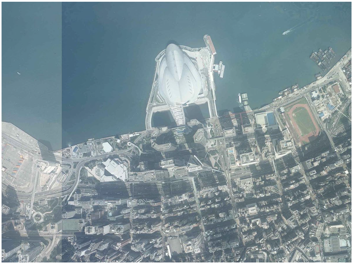
Old aerial photos of Site 4 in Wan Chai in 2019 (Source: HKMS2.0, 2023).
Throughout these phases, the urban form of Wan Chai has evolved through a combination of planned interventions and organic growth facilitated by economic impetus and social-political changes. This process has resulted in four distinct and fragmented morphogenetic regions, Sites 1 to 4, which reflect the adaptation of human settlements to historical contexts and contemporary needs.
This section describes and compares the old and newly emerged urban patterns across the six phases of Wan Chai in Hong Kong from the perspectives of physical and spatial elements and socio-economic context. Each phase introduced different spatial structures and formed morphogenetic regions. Phase 1 shaped irregular street grids influenced by natural topography. With minimal infrastructure and no formal survey, Site 1 initially served as a support area for shipping companies, featuring piers, warehouses, and a few British residential plots. Phase 2 featured a relatively regular N–S street grid for marine trade and storage efficiency. Residential plots were surveyed. The construction of tenement buildings and new warehouses on these plots were driven by the port economy. Phase 3 shifted to E–W street grids to improve island-wide transportation and accommodate manufacturing growth. Streets grew wider and more regular to enhance transportation. The mixed land uses accommodated different demands and enhanced land use efficiency. Phase 4 practiced modernist planning and introduced larger-scale street block grids, almost three times the size of previous street blocks, which accommodated high-rise podium-tower complexes supporting the booming service economy. Phases 5 and 6 extended the sparse urban patterns of Phase 4, developed mega-structure and infrastructure, and enhanced the transportation connectivity through port expansion and underground metro construction.
Street block patterns formed at each stage have experienced long-term transformations, changing original features and spatial relations. Urban regeneration at each site has altered original physical patterns and reinforced the morphological diversity. For example, some larger plots with podium-pedestrian towers emerged from the aggregation of originally small-scale plots with compact street blocks from the 1950s to the 1970s. Additionally, a large-scale real estate project merged two street blocks traditionally oriented north-to-south, shifting the urban fabric.
Beyond land reclamation, newly emerged composite elements and spatial structures, along with evolving planning ideologies, have further shaped different urban forms in Wan Chai. In Phases 4 to 5, the introduction of footbridges and elevated walkways in 1970s changed access relations between people, streets, plots, and buildings. The Wan Chai urban fabric consists of a multi-layered structure, i.e., above ground, at ground level, and underground, connected horizontally and vertically through podium walkways, footbridges, underground tunnels, lifts, and escalators, further intensifying morphological complexity. Urban transformation in Wan Chai is closely linked to land reclamation and responds to shifts in land use driven by socio-economic demands, including port trading, industrialization, and service economy. These changes have created a diverse and intricate urban form that remains unified within a basic street grid framework.
Evolution of volumetric structures of Wan Chai
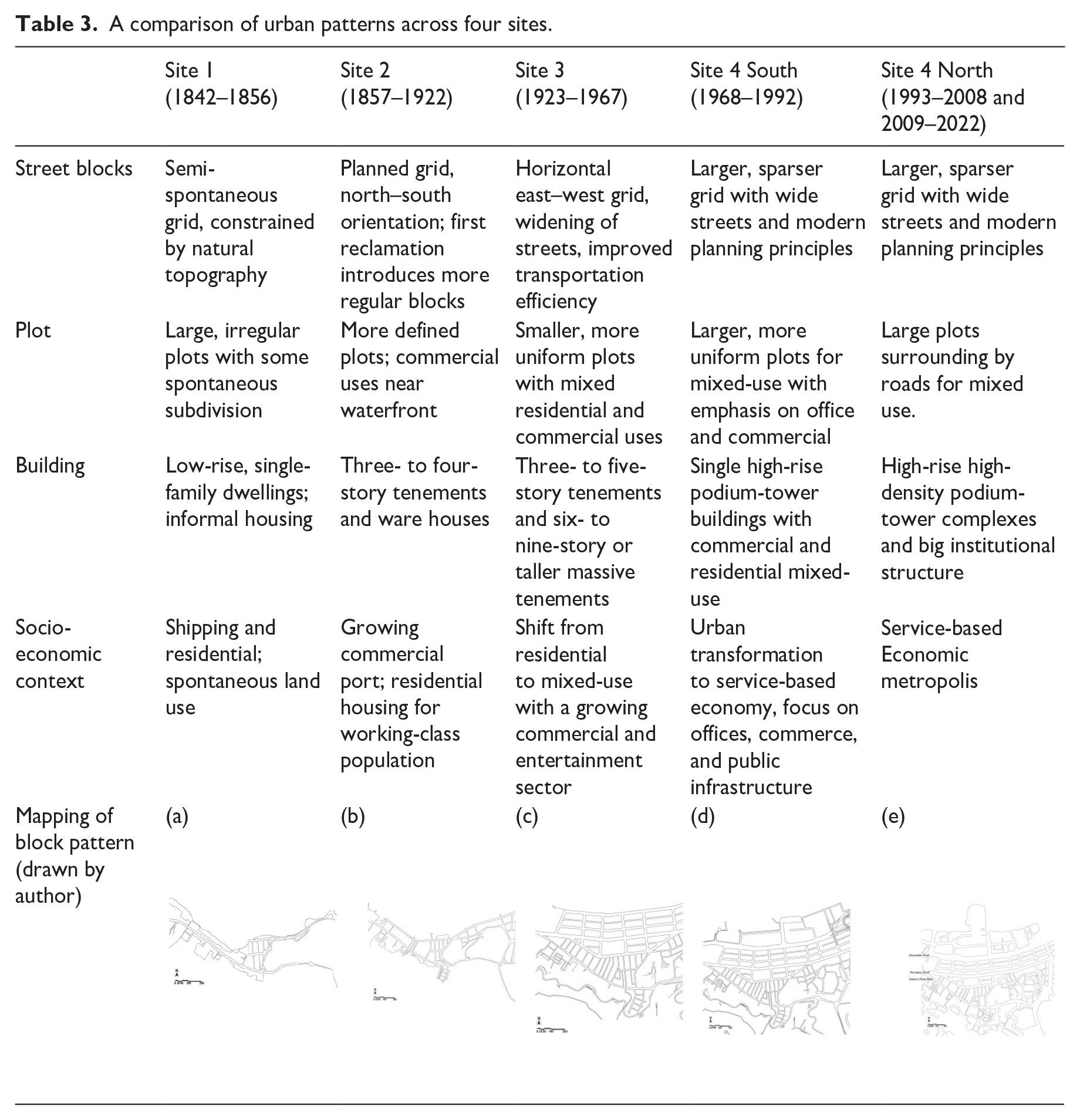
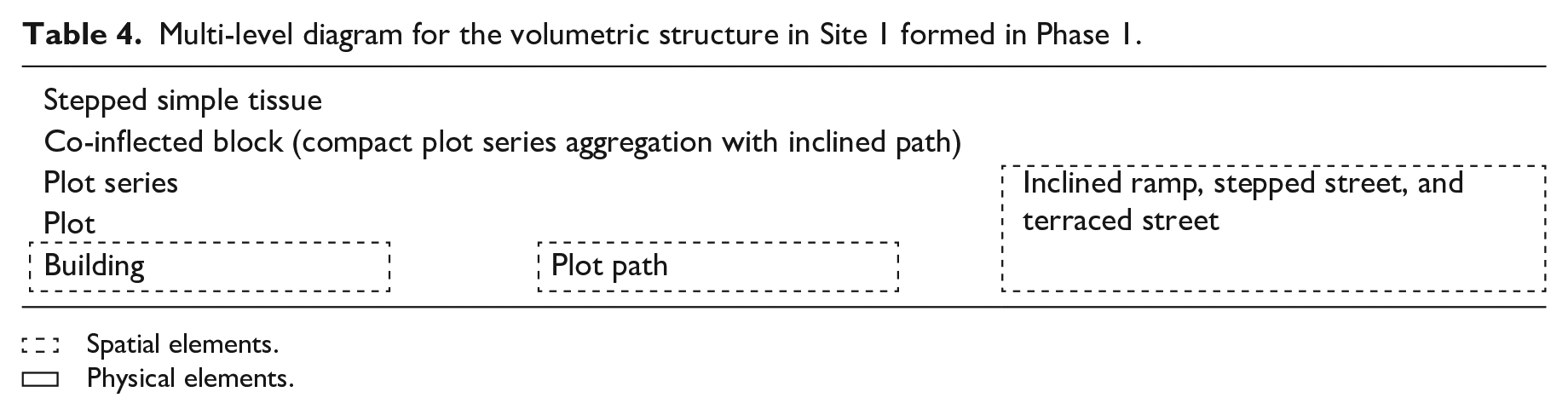
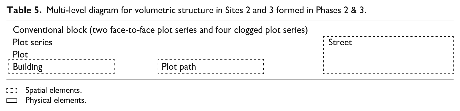
To understand the evolution of urban form in Wan Chai, this study compares the urban patterns and volumetric structures of four distinct morphogenetic sites across six phases. Each site formed during a specific phase, except for the last site, which was shaped across two phases. The comparison examines key composite elements and the socio-economic contexts of each phase (Table 3). This section emphasizes the transformation of volumetric structures within street block patterns, as street blocks accommodate multiple human activities and social vitality, undergoing various changes throughout reclamation phases in Wan Chai (Tables 4–6). A detailed analysis of these elements and hierarchical access relations within volumetric structures reveals interrelations between phases, highlighting continuity and transformation, while providing a clearer understanding of the urban evolution.
A comparison of urban patterns across four sites.
Multi-level diagram for the volumetric structure in Site 1 formed in Phase 1.
Spatial elements.
Physical elements.
Multi-level diagram for volumetric structure in Sites 2 and 3 formed in Phases 2 & 3.
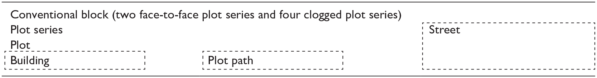
Spatial elements.
Physical elements.
Multi-level diagram for volumetric structures in Site 4 formed in Phases 5 & 6.
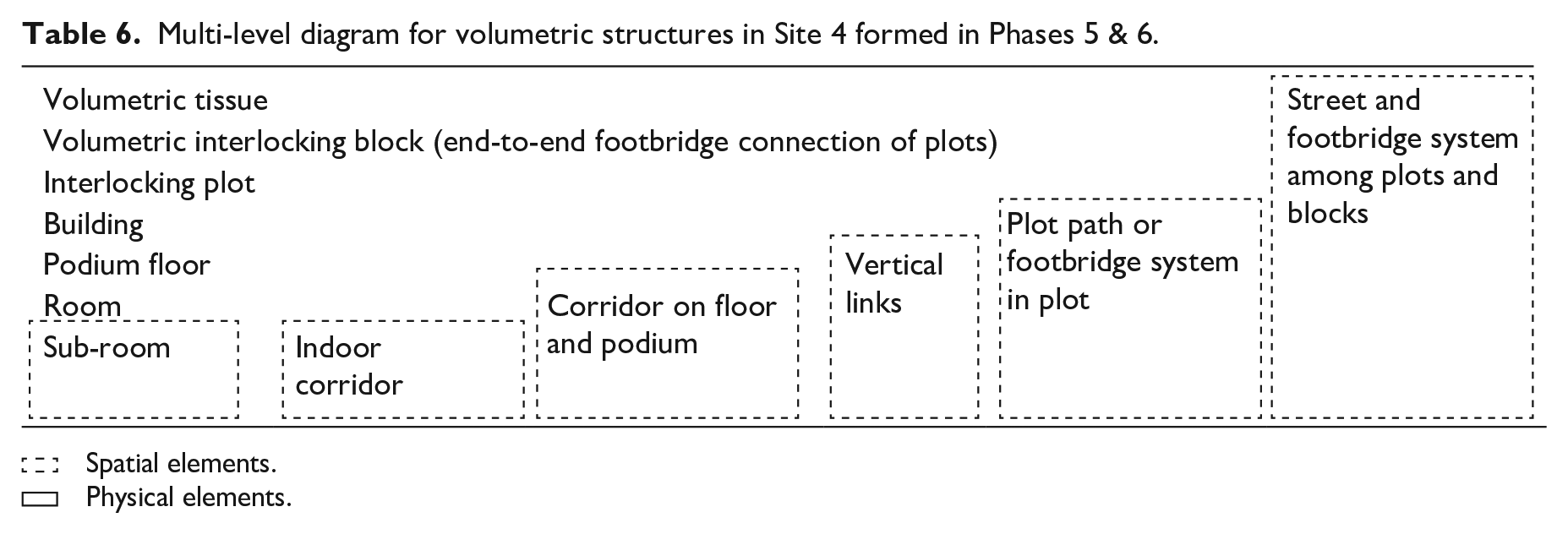
Spatial elements.
Physical elements.
Each volumetric structure that developed from a given phase is depicted by a multi-level generic diagram, indicating underlying physical and spatial components across various hierarchical levels (Tables 4–6). These multi-level diagrams can be applied and adapted to clearly express the evolution of volumetric structures in Wan Chai. The comparison of urban patterns and volumetric structures across four sites reveals both continuity and transformation.
In Site 1, the semi-spontaneous street grid (i.e., the stepped simple tissue), particularly on the southern side of Queen’s Road, was influenced by the natural hillside topography and lacked a detailed land survey. Land division was primarily driven by the needs of the shipping industry and residential demands (Table 3a). The irregular street blocks were typified as co-inflected block types with obscure boundaries and compact plot series that adapted to the complex topographic conditions. The street pattern, consisting of inclined ramps, stepped streets, and terraced streets, emerged in Phase 1 and continues to influence the framework today. Table 4 illustrates the hierarchy of physical and spatial elements within the volumetric structure of Site 1.
As Wan Chai expanded into Site 2, the street block grid developed into a more regular, colonial, north–south block, which facilitated trade and transportation between piers and warehouses (Table 3b). The colonial land survey produced street blocks of various shapes, including triangular, rectangular, and trapezoidal, and sizes to fit between the new shoreline and Queen’s Road. To maximize land use within limited land supply, the regular plots together with heteromorphic ones comprising plot series were created. Three- to four-story tenement buildings became the dominant residential building type to accommodate a surging working-class population. These tenements occupied small plots and featured regulated room arrangements influenced by local sanitary and ventilation standards. Phase 2 overlapped with the increasing role of Wan Chai as a key port for trade.
In Site 3, a colonial-style, a regular east–west street block grid was laid on the flat reclaimed land, running parallel to the coastline (Table 3c). Phase 3 introduced a more consistent shape and size for conventional blocks and plots. Driven by practical land use demands, the street pattern of Site 3 improved transportation efficiency across the island, reducing pressure on the original north–south streets of Site 2. With wider streets and more regular plots, this phase saw a rise of residential developments. Plot sizes increased. Massive six- to nine-story tenement buildings emerged to accommodate collective living needs, while three- to five-story tenements remained the dominant residential building type. Table 5 illustrates the hierarchy of physical and spatial elements within the volumetric structure of Sites 2 and 3.
Site 4 underwent significant changes and introduced large and sparse street grids with wide roads, influenced by the Modernism Movement (Tables 3d and 3e). The gridiron pattern expanded upon previous street block patterns, accommodating larger plots for civil institutions, commercial complexes, and new infrastructure, such as MTR stations. Streets were widened to prioritize vehicle transportation, while pedestrian pathways were elevated to the second floor, reflecting a shift towards automated transport. The emergence of high-rise and high-density podium-tower buildings responded to the increasing demand for space in the city and the booming service economy. However, the enlarged scale of street blocks, plots, and buildings diminished street-level vibrancy, a concern highlighted by urban theorists such as Jacobs (1964) and Moudon (1986).
The street block volumetric structure in Site 4 requires redefinition with the addition of new elements and hierarchical relations (Table 6). Newly introduced spatial components, including stairs, footbridges, podium walkways, indoor corridors, and underneath passageways from public to semi-public and private spaces, have been added into a more complex volumetric structure. Buildings, podiums, and floors are no longer discrete and isolated within large plots but are instead interconnected through these newly defined spatial elements in the circulation network. Modern high-rise podium-towers emerged to meet residential needs, characterized by land aggregation, technology advancements, and new design principles that separated individual access from the plot and street. This shift introduced semi-public circulation spaces and redefined pedestrian circulation within the volumetric urban structure, forstering a new form of pedestrian-street interaction surface for volumetric street life in Wan Chai. Table 6 illustrates the hierarchy of physical and spatial elements within the volumetric structure of Site 4.
Some physical elements evolved from traditional types into new types, altering their relations with other elements and changing their hierarchical levels in the volumetric structure. Conventionally, single-sided simple tissue is composed of a plot series aligned along one side of a double-loaded street (Table 4). The entries to these plots all face the same street, creating a straightforward, one-to-one linear access relation between the plot and the street. Colonial gridiron patterns typically feature interlocking blocks, formed either by two back-to-back pertinent strips or four-sided clogged pertinent strips surrounded by streets (Table 5). These interlocking blocks replaced simple tissue and became the primary constituents of urban tissue. As a result, simple tissue has disappeared. In northern Wan Chai, interlocking plots have largely replaced plot series and simple tissue, shaping the broader urban tissue (Table 6).
Implications for urban planning and conclusion
Throughout the successive reclamation phases, four principles of transformation are summarized. First, the gradual evolution of street block patterns preserves the continuity of historical spatial frameworks while adapting to new living and working demands driven by economic and social changes, such as industrialization and the growth of the service sector. Second, the gradual shift from irregular and informal urban forms in Phase 1 to more organized, mixed-use urban patterns in Phase 3 was shaped by the persistence of plot sizes and street block scales. Third, the slower, gradual evolution of small plots and blocks helps integrate new developments with the cultural identity of the area, fostering heritage preservation and vibrant street life. Finally, the aggregation of plots and blocks in later phases accommodated large podium-tower residential buildings, responding to the land shortage, evolving lifestyles, and technological advancements.
From Phase 3 to Phase 4, block sizes increased markedly, showing the adaptation of urban form to changing urban functions and land uses. The expansion of street block grids accommodated large-scale building types, including commercial structures and civic institutions. This transformation aligns with broader urban development trends, where block size and configuration are influenced by the scale and uses of newly emerging building types. Additionally, the reduction of on-ground streets and the introduction of podium walkways and footbridges were influenced by traffic-oriented and land-efficient modernist thoughts. The street block patterns in Wan Chai evolved reactively to practical demands and constraints, i.e., a process of reactive adaptation. Key influencing factors included local terrain, transportation routes, dominant land functions, and prevailing building types. The layout continuously adapted to optimize land use, enhance transportation efficiency, and support economic viability. Finally, new physical and spatial elements, such as large interlocking plots, footbridges, and elevated podium walkways, reshaped the basic spatial hierarchy. The access relations between buildings, plots, blocks, streets, and tissues became more complex, introducing additional hierarchical levels. This transformation provided a new type of social interaction surface and dynamic street life in Wan Chai.
The evolution of street block patterns in high-density Wan Chai provides lessons for future urban development. First, new developments need to maintain the historical continuity. The initial gridiron layout provided a resilient framework that adapted to changing needs while maintaining historical patterns. Future developments should integrate historical street grid patterns to ensure continuity in the urban fabric. Second, smaller plots and blocks foster diversity and gradual renewal, supporting vibrant pedestrian environments and varied urban forms. Urban planners can apply principles of piecemeal regeneration to preserve the spatial connectivity and social identity in similar high-density cities. Third, urban transformations result from both incremental changes by less powerful forces and radical changes by dominant entities. Effective urban planning needs to balance these forces to maintain stability while allowing for necessary adaptation. Fourth, the integration of new spatial elements with the existing spatial framework introduced new everyday pedestrian life to volumetric public spaces in Wan Chai, which formed vibrant social interactions in the high-density context. Finally, modern urban design needs to embrace mixed-use developments, integrating transportation, land use, and building types to create adaptable and resilient urban environments. Planning methods and design standards should accommodate evolving lifestyles, socio-economic shifts, and technological changes.
Beyond demonstrating the application of adapted and updated urban morphology methodologies in compact and volumetric urban forms, this paper analyzes the historical formation, transformation processes, spatial and physical elements, hierarchical relations, and spatial structures across four high-density sites in each phase of Wan Chai. The distinct volumetric structures of each site are mapped and compared in terms of their street blocks, plots, building characteristics, and socio-economic context. The study of urban fabric transformation over time reveals critical principles of street block patterns and their adaptability to changing topographic and socio-economic conditions in Wan Chai. This study focuses on the evolution of street block configuration from 1856 to 2022 and emphasizes key transformation principles shaping high-density urban forms.
The comparison and analysis of volumetric structures across typical sites provide an understanding of seemingly disproportional contemporary urban patterns and key transformation principles. The temporal and spatial characteristics embedded in volumetric structures at different levels in Wan Chai help decode the composite elements and hierarchical relations of urban patterns during transition processes. Such characteristics are easily captured by other approaches in urban morphology. The results provid a tool for further studies, such as investigating the relationship between walkability, environmental quality, and morphological patterns. In practical urban design application, an assessment of depth, width, and dominant relation types within volumetric structures can greatly influence the feasibility of physical layouts and spatial arrangements in the urban form.
This study applies and enhances morphological approaches to analyze the volumetric urban form of Wan Chai. Although these methods are not constrained by cultural, economic, or geographic factors, they primarily focus on how spatial structures evolved in high-density physical urban forms. When applied to other high-density regions with different cultural, economic, and geographic contexts, the methods proposed in this study, such as volumetric structure and hierarchical relations, can be adapted to interpret spatial structures of other high-density areas in East and Southeast Asia.
Footnotes
Acknowledgements
The authors would like to thank the University of Hong Kong for providing the Research Postgraduate Scholarships from 2017 to 2021. The authors acknowledge advice of abstract revisions from Dr. Yanjie Mu and Miss Moyun Zhou at the University of Hong Kong.
Author contributions
Declaration of conflicting interests
The author(s) declared no potential conflicts of interest with respect to the research, authorship, and/or publication of this article.
Funding
The author(s) received no financial support for the research, authorship, and/or publication of this article.
Ethical statement
This article does not contain any studies with human or animal participants.
Consent to participate
Not applicable. There are no human participants in this article and informed consent is not required.
Consent for publication
Not applicable. There are no human participants in this article and informed consent is not required.