
Abstract
Unprecedented urbanisation processes characterise the Great Acceleration, urging urban researchers to make sense of data analysis in support of evidence-based and large-scale decision-making. Urban morphologists are no exception since the impact of urban form on fundamental natural and social patterns (equity, prosperity and resource consumption’s efficiency) is now fully acknowledged. However, urban morphology is still far from offering a comprehensive and reliable framework for quantitative analysis. Despite remarkable progress since its emergence in the late 1950s, the discipline still exhibits significant terminological inconsistencies with regards to the definition of the fundamental components of urban form, which prevents the establishment of objective models for measuring it. In this article, we present a study of existing methods for measuring urban form, with a focus on terminological inconsistencies, and propose a systematic and comprehensive framework to classify urban form characters, where ‘urban form character’ stands for a characteristic (or feature) of one kind of urban form that distinguishes it from another kind. In particular, we introduce the Index of Elements that allows for a univocal and non-interpretive description of urban form characters. Based on such Index of Elements, we develop a systematic classification of urban form according to six categories (dimension, shape, spatial distribution, intensity, connectivity and diversity) and three conceptual scales (small, medium, large) based on two definitions of scale (extent and grain). This framework is then applied to identify and organise the urban form characters adopted in available literature to date. The resulting classification of urban form characters reveals clear gaps in existing research, in particular, in relation to the spatial distribution and diversity characters. The proposed framework reduces the current inconsistencies of urban morphology research, paving the way to enhanced methods of urban form systematic and quantitative analysis at a global scale.
Introduction
In the age of urbanisation, urban planning and design still struggle to offer reliable models to address the challenges of the 21st century (Cuthbert, 2007; Romice et al., 2020), while the discipline’s shift towards an evidence-based approach and a ‘new science of cities’ is still in its infancy (Batty, 2012: S15). Despite remarkable growth and progress, urban morphology—the area of urban studies that focuses on cities’ physical form, its patterns of change in time and relations with non-spatial dynamics—is no exception. In particular, two issues still hinder a quantitative approach to the analysis of urban form: first, the availability, quality and consistency of data across geographical regions; second, the discipline’s inherent difficulties to offer a rigorous and consistent definition of urban form, its fundamental components and the relationships between them. This paper offers a contribution towards the resolution of this second problem.
The high variety of measurable urban form characters, defined as a characteristic (or feature) of one kind of urban form that distinguishes it from another kind (adapted from Dibble et al., 2017 and Sneath and Sokal, 1973), used in urban morphology literature is fragmented across numerous unrelated sources, and despite several attempts to systematise it (Caniggia and Maffei, 2001; Conzen, 2004; Dibble et al., 2017; Larkham and Jones, 1991), a comprehensive overview is still lacking. This gap of knowledge creates uncertainty as to which research areas are covered and which need further research. Moreover, terminology is neither consistent nor univocal, resulting in weaker methodological compatibility and higher hurdles in comparing research outputs. According to Whitehand (2012), comparative research is faced with a plethora of case studies that use different, or sometimes unspecified, definitions. […] In addition to problems of non-comparability of definitions, methods and concepts, differences between the sources of information employed need to be overcome. (p.60)
Research method
In this section, we present (1) the criteria utilised to select relevant literature used to map the field of urban morphology; (2) the process of systematisation of such literature, which we then use to (3) identify, cross-compare, (re)define and (4) re-classify urban form characters.
As for our own terminology, terms such as ‘attribute’, ‘variable’, ‘measurement’, ‘metric’, ‘index’, ‘character’, ‘indicator’ or ‘proxy’ are often used interchangeably in urban morphology to signify the measurable feature of an object (Araldi and Fusco, 2019; Bobkova et al., 2017; Dibble et al., 2017; Schirmer and Axhausen, 2015; Vanderhaegen and Canters, 2017) . In this paper we follow Dibble et al. (2017) where the term ‘character’ defines ‘a characteristic (or feature) of one kind of organism that will distinguish it from another kind’ (Sneath and Sokal, 1973). Here, however, ‘organism’ refers to a distinct kind or type of urban form. ‘Urban form’ as a term has been used to loosely signify different aspects of space’s configuration in cities along with its use and agents, and is therefore a polysemic term, while in this work we refer exclusively to the physical components of urban space, i.e. the built-up fabric (blocks, streets, buildings, etc.) and its fundamental spatial subdivision (plots) after Moudon (1997).
To review the literature (Figure 1), we selected sources that (1) explicitly undertake a quantitative examination of urban form characters 1 ; (2) include urban form characters that are not present in already selected sources, to avoid unnecessary duplication and overlapping.
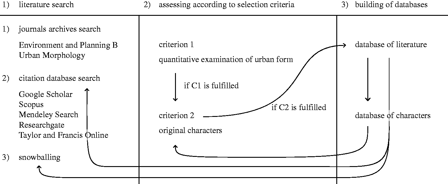
Scheme of the process of selection of literature and its usage.
First, we looked at papers published in two leading journals of urban analytics and morphology: Environment and Planning B and Urban Morphology. From here, we extracted keywords, which we then used to identify a number of academic citation databases (Google Scholar, Scopus, Mendeley Search, ResearchGate, Taylor and Francis Online) and then undertook a wider snowballing exploration. The process of keyword search and snowballing was iterated whenever new inputs were found and adopted to ensure that the selection is rigorous and inclusive.
All selected papers were then classified according to: (1) grain, i.e. the scale (size) of the basic spatial unit on which descriptors are calculated; (2) extent, i.e. the scale (coverage) of the case study; (3) purpose; (4) potential comprehensiveness, i.e. the number of urban form characters measured; (5) timeframe, whether synchronic (comparing different cases at the same time) or diachronic (comparing the same case at different times).
For grain, we considered the basic spatial unit as the smallest element being measured, while for extent, we considered coverage as the total area of the case study analysed. Both are taken into account and then organised from 1 (small) to 10 (large). 2
We then extracted individual urban form characters from the sources classified as above. Those influenced by non-morphological data, such as distance to the nearest bus stop (Song and Knaap, 2007) or land use (Dibble et al., 2017), were excluded.
To overcome terminological inconsistencies among the urban form characters adopted in different studies, 3 we comprehensively redefined them (see ‘Classification of urban form characters’ section). On these new definitions, we then designed a classification framework of such characters, based on their nature and the spatial unit they belong to. Finally, we tested such framework in the classification of all urban form characters initially extracted from literature, discussed the emerging gaps and redundancies and suggested further developments.
Literature review
While the existing literature on urban morphology shows a historical inclination towards qualitative methods (Dibble et al., 2015), through the iterative literature review process illustrated above, we identified 72 predominantly quantitative works (peer-reviewed articles, conference papers, book chapters, PhD theses). In Figure 2, selected literature items are positioned according to their grain and extent scales, and classified by their purpose (colour), and number of urban form characters considered (size).
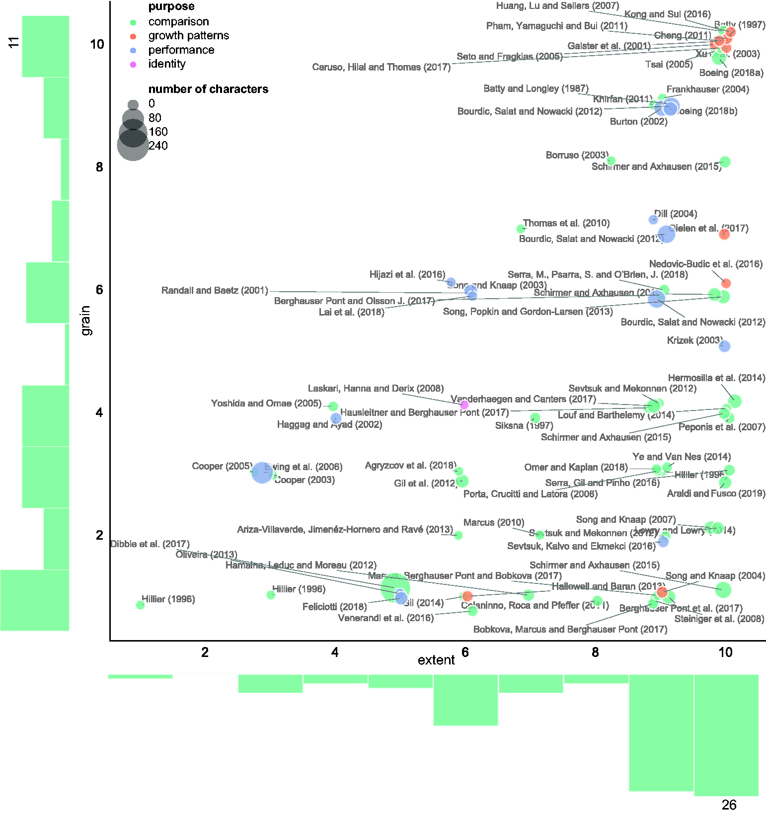
Classification of literature. Predominantly quantitative studies in urban morphology classified according to grain scale (Y axis), extent scale (X axis), purpose (colour) and number of urban form characters (size). The histograms show a relative balance in terms of scale of grain and a tendency towards large scales of extent. Note: placement of points is jittered to minimise overlaps.
Patterns of research
Quantitative analysis in urban morphology appears to have three distinct research purposes in particular: to enable comparison among cases, to measure the performance of urban form and to monitor or predict urban growth. Comparison is the largest group containing 45 out of the 72 selected works (62%), and is significantly synchronic (95%). It includes studies which cover a range of urban form characters from only one (Agryzcov et al., 2018; Ariza-Villaverde et al., 2013; Batty and Longley, 1987; Frankhauser, 2004; Thomas et al., 2010) to many (Dibble et al., 2015, 2017); however, those covering more than 10 urban form characters are only the 33%, and those with more than 25 the 15%, demonstrating a lack of comprehensiveness in literature.In terms of scales, comparative studies tend to be lower in grain scale (more detailed) and higher in extent scale (larger case studies).
Papers measuring performance refer in particular to one specific aspect of urban form, such as sustainability (Bourdic et al., 2012; Haggag and Ayad, 2002), resilience (Feliciotti et al., 2016), urbanity (Oliveira, 2013) or network-based accessibility (Krizek, 2003; Sevtsuk et al., 2016). Similar to the comparison group, the majority of works in this second group is synchronic. However, unlike comparative studies, they tend to use similar scales for both grain and extent.
Not surprisingly, studies on urban growth are mostly diachronic. Many publications in this group focus on the analysis of urban sprawl (Galster et al., 2001; Song and Knaap, 2004) to capture sprawl indices (Gielen et al., 2017); here data are often aggregated and classified in a built–unbuilt binary framework (Galster et al., 2001; Seto and Fragkias, 2005), enriched by Cellular Automaton (Batty, 1997; Kong and Sui, 2016) or machine learning (Cheng, 2011) techniques. As growth is measured mostly at metropolitan scale, with a few exceptions (Hallowell and Baran, 2013), all works focus on large scale of extent, while mostly using the same scale of grain.
Crucial for the success of a comparative method is complexity. This is represented by both the cross-scale extent of the research, as reflected for example in the work of Song and Knaap (2007), later refined by Song et al. (2013) or Schirmer and Axhausen (2015), 4 and the number of urban form characters measured (potential comprehensiveness). Still, over the whole set of 72 literature items selected, those measuring a number of urban form characters large enough to minimise biases and errors (i.e. >25 urban form characters) is relatively rare (15%). Only recently, a few such comprehensive studies started to emerge (Bourdic et al., 2012; Dibble et al., 2017; Ewing et al., 2006; Oliveira, 2013; Schirmer and Axhausen, 2015), contributing to the growing area of urban morphometrics (Carneiro et al., 2010; Dibble et al., 2017; Feliciotti et al., 2017). However, the sheer number of urban form characters scrutinised (comprehensiveness) does not necessarily ensure complexity, as many of them may be collinear and hence capture the same information.
Classification of urban form characters
The review of the 72 quantitative studies illustrated above produced a list of 465 individual measurable urban form characters: of these, many were duplicated or hidden under the same name (‘nicknaming’), suggesting the persistence of significant nicknaming even in the quantitative area of urban morphology analysis. For example, the term ‘connectivity’ is in some cases used to signify a broader group of urban form characters (usually related to network analysis) (Dibble et al., 2017), while in other cases is attributed to one single one of them, and yet with different meanings (Hillier, 1996; Lowry and Lowry, 2014); in some instances the term is used in both ways in the same study (Bourdic et al., 2012).
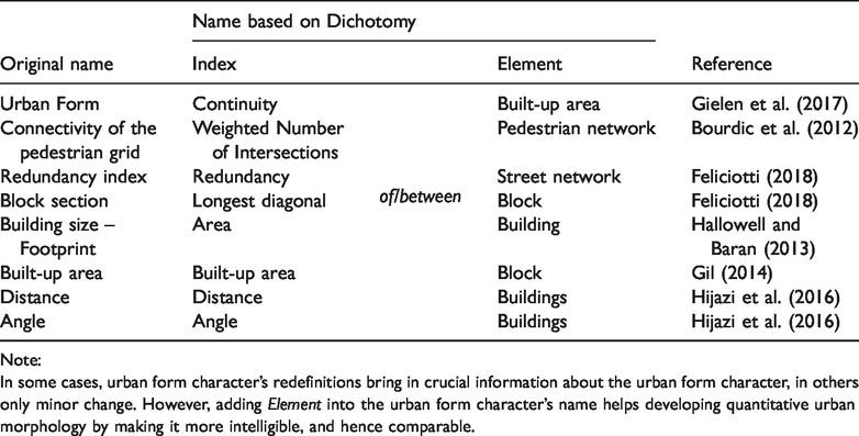
Hence, we undertook a process of ‘character redefinition’, and introduced the ‘Index of Element’ aimed at achieving a higher degree of consistency between the name of urban form characters and their substance. This index essentially defines each urban form character according to the measure that it calculates (the Index) and the element of urban form that it measures (the Element). If we consider the ‘connectivity’ of the pedestrian grid in Bourdic et al. (2012) for example, we can easily distinguish the measure being calculated (Index), which is a weighted number of intersections, and the ‘thing’ the urban form character of which is calculated (Element), which is the pedestrian network. This brings us to redefine the measure as ‘Weighted Number of Intersections of Pedestrian Network’, leaving much narrower room for interpretation. The use of a rigorous terminological criterium such as the Index of Elements is, even in quantitative urban morphology analysis, still occasional, though not absent (Schirmer and Axhausen, 2015). The Index of Element helps achieve an understandable definition of urban form characters by their same name: the Index part of the name captures the nature of the measure, independently from what is measured, while the Element part of the name captures the nature of what is measured, independently from how it is measured. Urban form characters defined by the combination of the two become consistently understandable and comparable across different methods. Application of this method on 465 identified urban form characters led to the elimination of 104 cases of duplication (22.4%), leaving 361 uniquely defined ones (Table 1).
Examples of Index of Element conversions.
Note:
In some cases, urban form character’s redefinitions bring in crucial information about the urban form character, in others only minor change. However, adding Element into the urban form character’s name helps developing quantitative urban morphology by making it more intelligible, and hence comparable.
Having tackled the terminology issue, we developed a typology of urban form characters directly based on their name (which now captures their definition). This is a ‘concept-based classification’, i.e. one ‘which conceptually separates a given set of items multidimensionally … the key characteristic of a typology is that its dimensions represent concepts rather than empirical cases’ (Smith, 2002: 381). In this sense, by examining the urban form characters’ names we classify them along three dimensions: (1) the nature of the Index, (2) the scale of the grain of the character and (3) the scale of the Element’s extent.
While most authors classify their observed urban form characters in groups, which are usually case-specific, these classifications vary. Generally, we can identify two approaches: one refers to the urban form character’s scale, as for example the sequence Object, Composition, Neighbourhood, District, Municipality and Region in Schirmer and Axhausen (2015); the second refers to the Element’s nature, as for example in Song, Popkin and Gordon-Larsen’s (2013) Permeability, Vitality, Variety, or equally in Bourdic et al.’s (2012) Intensity, Distribution, Proximity, Connectivity, Complexity, Diversity, Form.We propose that the first step in the classification of urban form characters follows the nature of the measure itself, which is captured in the Index part of its Name. On this ground, we build on Bourdic et al.’s (2012) classification, adapting it to reflect the needs of a general analysis of urban form. 5
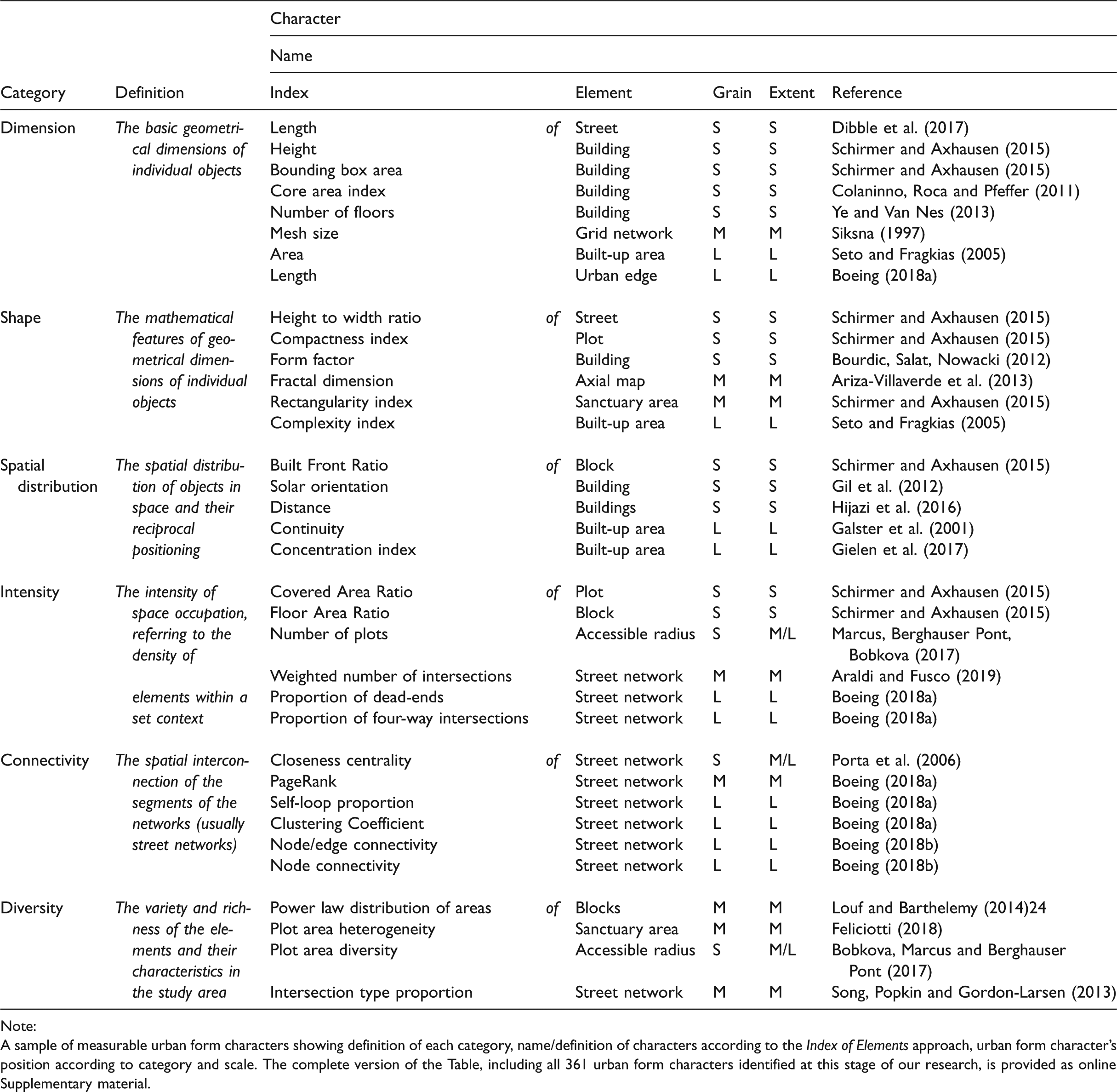
Hence, we first distinguished in the Index six categories that are ontological (they express the nature of the Index): 1. Dimension, 2. Shape, 3. Spatial distribution, 4. Intensity, 5. Connectivity, and 6. Diversity. These six categories are in a ranked order from the simplest (1. Dimension) to the most complex (6. Diversity). For example, ‘Weighted Number of Intersections of Pedestrian Network’, where the term ‘Weighted Number of Intersections’ is the Index and ‘Pedestrian Network’ is the Element will be classified as an urban form character of Index category ‘4. Intensity’. The six categories are not purely independent, as we can identify functional relationships between them. Often urban form characters in latter groups are mathematically dependent on others in the former: for example, those indexed by Elongation, which fall in the ‘2. Shape’ category, are functionally dependent on those indexed by Width and Length, which fall into ‘1. Dimension’, since Elongation = Width/Length ratio. Also, we classify the urban form character into three categories that capture its grain – the scale of the spatial unit in which the unique value is stored. Finally, we distinguish in the Element three categories that are descriptive of the scale at which the element itself occurs (equivalent of scale of spatial extent in Figure 2), is observable and measurable in urban morphology.
Since many measurable urban form characters in literature work at multiple scales, in our classification we need to maintain a certain level of breadth in defining the amplitude of scale. Therefore, we are proposing three conceptual levels of scale only: Small (S) representing the spatial extent of building, plot, street or block (and similar), Medium (M) representing the scale of the sanctuary area (Mehaffy et al., 2010), neighbourhood, walkable distance (5 or 10 min) or district (and similar) and Large (L), representing the city, urban area, metropolitan area or similar. Thus, to continue with our example, the urban form character ‘Weighted Number of Intersections of Pedestrian Network’, would be classified based on (1) its grain and (2) the scale of its Element ‘Pedestrian Network’. In this case, networks as physical entities occur and have meaning, and therefore can be observed and measured at the larger (M, L) scales, while they do mean very little at the small scale. Because the network in this case refers solely to pedestrian use, the urban form character falls into the category M of scale, or alternatively M/L if we allow more flexible cross-scale definition which might be desirable in general, as it softens the hard boundaries which might not be applicable to some, accounting for the authors’ specific conceptualisation of spatial scale (such as Space Syntax). As this urban form character measures a single number per network, the scale of its grain and that of the extent of its Element coincide. However, that it not the case in all situations: for example, Closeness Centrality of Street Network is measured on the larger network (M, L scales), while the value is specific for each node (S scale). 6
The resulting typology offers an unambiguous identification of each urban form character based on its very nature, as reflected in its name (Table 2).
Table of urban form characters (extract).
Note:
A sample of measurable urban form characters showing definition of each category, name/definition of characters according to the Index of Elements approach, urban form character’s position according to category and scale. The complete version of the Table, including all 361 urban form characters identified at this stage of our research, is provided as online Supplementary material.
Interpretation
The summative statistics of the complete Table of Urban Form Characters offers in-depth information into the current state of how terminology is defined and used in the field. The distribution of urban form characters across the scales of extent shows a slight decline as we proceed from Small to Large scales, but the distribution is relatively balanced (Figure 3(b)). In terms of the scale of grain, it is naturally skewed towards Small scale (Figure 3(a)). The situation changes if we explore the distribution of urban form characters among the six different categories established at the start of our classification. In this case, spatial distribution and diversity are underrepresented (with respectively 27 and 13 urban form characters), while all other categories each contain relatively high numbers each (from 55 in connectivity to 115 in intensity) (Figure 3(c)). One of the reasons for this distribution is that dimension, shape, intensity and connectivity are much easier to capture than spatial distribution or diversity, and their urban form characters are simpler to define.
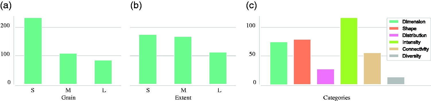
Number of urban form characters per scale of grain (a), scale of the extent (b) and number of characters per category (c). Note that some characters are present at multiple scales.
To understand the distribution of urban form characters in better intra-category detail, we used decomposed statistics (Figure 4), which helped understand the relationship between categories and both definitions of scales. Dimension and shape categories tend to be significantly more present at the Small scale, from both perspectives. At this scale, physical features tend to be more precisely defined, hence it is natural that their dimensions and shapes are measured at the same scale. On the other side is connectivity, being present exclusively at larger scales (M, L) of extent, but being skewed towards smaller scales of grain. This is an inherent consequence of the nature of this urban form character which is typical of networks, easier to identify at larger scales of the environment in which they are observed, while the values are often unique for each component of network (as mentioned above).
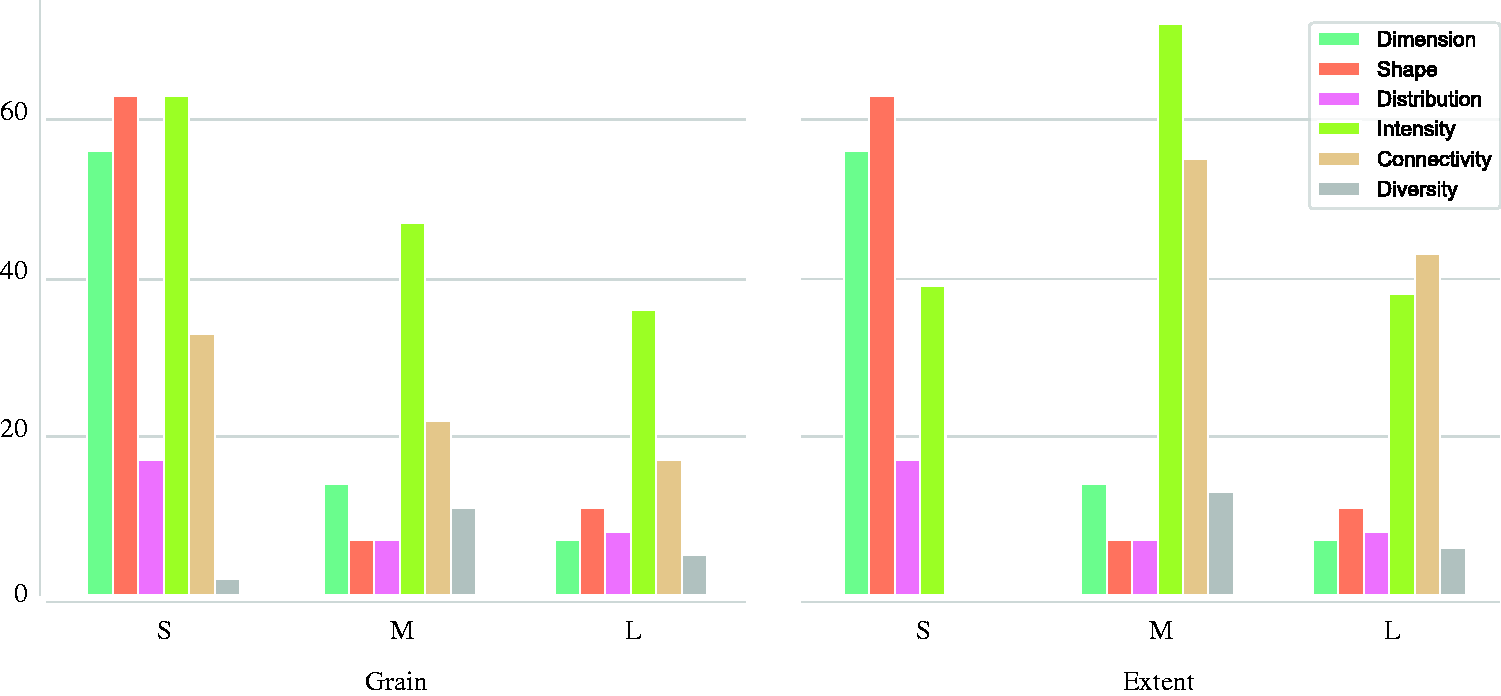
Number of urban form characters per each scale decomposed to each category. Note that some urban form characters are present at multiple scales.
The overview of urban form characters shows some clear recurring patterns from the perspective of (both) scales as well: it is worth noting that complex urban form characters are more likely to be measured at larger scales of extent (M, L). This seems to be partially caused by the nature of our classification system, where the limited amount of data inputs at a small scale makes results for more compound and aggregated urban form characters less reliable. However, at the same time, this pattern is posing the question of whether information is being missed out in this overview. Not even one of the six categories shows a balanced coverage of all three scales (for both grain and extent). We can question which parts of the classification are less comprehensive for a logical reason (smaller scales are not suitable for complex relational urban form characters) and which are so just because some may have been missed out.
Back to the issue of spatial distribution and diversity, the former seems to differ across scales (the scales of grain and extent are identical for all urban form characters in spatial distribution and, with the exception of 2, in diversity as well). Seventeen out of 27 urban form characters in spatial distribution category are present at S scale. While the number is still lower than for the other groups (except diversity), the gap seems to be more significant at larger scales. The situation with diversity appears similar, featuring a majority of urban form characters at M scale (15 in terms of grain and 17 in terms of extent), but the overall number is too low to conclude scalar dependency, even though such a tendency might be present.
An issue revealed by the proposed classification of urban form characters is the overlap and at times redundancy of some of them (the empirical correlation between urban form characters which makes some redundant). This is most evident among those capturing shape at the level of the block and below. Here a high number of such characters are utilised in literature to capture the objects’ geometry and form. Basaraner and Cetinkaya (2017) assessed the capacity of some of the urban form characters to capture the complexity in shape of building footprints and concluded that only 6 out of 20 generally used are appropriate (p. 1972). Similar assessment should be done for other types, to rule out redundancy and increase the effectiveness and reliability of the fewer selected. On the other hand, the fact that certain types of urban form characters are abundant and might overlap or even lead to redundancy suggests that there is a general agreement on their value as descriptors of urban form.
Finally, terminological inconsistency could be explained by two causes. On one hand, the current lack of a comprehensive framework for the systematisation and comparability of urban form characters,, while on the other, the relative novelty of quantitative methods in urban morphology. There is therefore urgent need for coherent terminology, as the amount of quantitative studies is expected to rise with the development of Geographic Information Systems (GIS), big data science, data mining as well as open data and volunteer-based mapping services. The problems of comparability of studies defined by Whitehand (2012) could be limited if a more rigorous typological system such as the Index of Elements proposed in this paper was applied which would leave room for the interpretation of urban form characters, while making them comparable. In this regard, this work is dependent on the scope of existing research and its validity is affected by the limits of the initial literature review. However, we would argue that the method used to select papers ensures a reasonable level of representativeness as demonstrated by the fact that we were able to extract and successfully systematise 465 urban form characters covering a significant number of measurements. The consequent systematisation, exemplified in Table 2 and reported in full in the Table of Urban Form Characters (see online supplementary materials), seems to be inclusive and coherent enough to make sense of all of them, and yet this should be seen as just an initial framework. The proposed systematisation is meant to be refined and expanded as research progresses, in an open repository of tested urban form characters which would be ideally a collective product of the urban morphology scientific community as a whole (Fleischmann, 2019). Moreover, the work could be expanded by the inclusion of other ways of conceptualisation of urban form, to cover land use or behavioural patterns (among others).
In reviewing the literature, we necessarily had to rely on previously defined descriptions of both urban form characters and measurements. In several cases, these proved to be vague, sometimes lacking any definitions and/or mathematical formulas. Therefore, our classification of such characters might not align perfectly with the original source work. Even if we were able to successfully classify all relevant urban form characters, it still might be possible to find in the future some that just do not fit into any of the six proposed categories (yet, it would still be possible to define it through the Index or Elements naming approach).
Conclusions
Quantitative approaches to urban morphology are critical to inform the long overdue undertakings of a new ‘sciences of cities’. The current state of the discipline is, however, to some degree inconsistent. To progress further, it is essential to understand what the limits and potentials of the existing measuring methods are, and where the gaps of knowledge are.
The terminology used is often unclear, methods and urban form characters vary in ways that is at times difficult to understand. This limits the development of comparative studies, which however are essential to evidence-based research.
In this paper, we presented a first attempt at systematically and comprehensively organising existing measurable urban form characters while overcoming terminological discrepancies. We collected a significant and representative sample of published literature and identified the main purposes of the research that underpinned it. From this sample, we extracted individual urban form characters capturing the physical structure of urban form and identified significant terminological inconsistencies (‘nicknaming’), which were seen as undermining the comparability of research outcomes across cases and methods. We then introduced a new terminological framework based on an Index of Element approach, which then we tested to redefine all the 465 urban form characters extracted from literature. As a part of a newly proposed conceptual typology, we organised them into six distinct and inclusive categories. The new framework allowed us to identify a degree of redundancy in both the definition of urban form characters and their measurements, which led us to produce a more rigorous set of final 361.
When analysing how these urban form characters have been deployed, we identified a few anomalies in the distribution of their qualifying categories: the most significant tendency is the underrepresentation of spatial distribution and diversity. Moreover, shape and dimension are predominantly used at smaller scales, connectivity at larger scales (this tendency does not seem to be a consequence of the nature of the urban form character, but rather the lesser production of research on this topic).
Future research on the quantitative analysis of urban form, or urban morphometrics, should aim at collectively building a reasonably reliable and stable typology of measurable urban form characters, in order to achieve consistency across methods and case studies. Furthermore, the area should progress in recognising and measuring the full scalar and structural complexity of urban form, and we should be more comprehensive with regards to scales.
Finally, urban morphometrics is meant in principle to enhance the study of correlations between the physical and non-physical aspects of the global urban phenomenon, towards a unitary model covering both and yet accounting for their inherent differences.
Supplemental Material
EPB910444 Supplemental Material - Supplemental material for Measuring urban form: Overcoming terminological inconsistencies for a quantitative and comprehensive morphologic analysis of cities
Supplemental material, EPB910444 Supplemental Material for Measuring urban form: Overcoming terminological inconsistencies for a quantitative and comprehensive morphologic analysis of cities by Martin Fleischmann, Ombretta Romice and Sergio Porta in Environment and Planning B: Urban Analytics and City Science
Footnotes
Declaration of conflicting interests
The author(s) declared no potential conflicts of interest with respect to the research, authorship, and/or publication of this article.
Funding
The author(s) disclosed receipt of the following financial support for the research, authorship, and/or publication of this article: This work was supported by the Axel and Margaret Ax:son Johnson Foundation as a part of The Urban Form Resilience Project.
Notes
Author biographies
References
Supplementary Material
Please find the following supplemental material available below.
For Open Access articles published under a Creative Commons License, all supplemental material carries the same license as the article it is associated with.
For non-Open Access articles published, all supplemental material carries a non-exclusive license, and permission requests for re-use of supplemental material or any part of supplemental material shall be sent directly to the copyright owner as specified in the copyright notice associated with the article.