
Abstract
The rise of megaregions is championed by those arguing that the 21st century will be dominated by vast expanses of transmetropolitan urban landscapes. Many argue that we are living in a ‘world’ and an ‘age’ of megaregions, where megaregions are both competitive territories par excellence and an important scale for urban planning. Nowhere does the spotlight shine more brightly than on China’s megaregions (chéngshì qún). In this paper we examine the new planning vision for megaregions in China’s 14th Five Year Plan (2021–25). We trace continuities and discontinuities from the 11th, 12th and 13th FYPs to emphasise the importance of adopting a strong spatial and temporal approach to researching megaregions. This analysis is then used to outline an agenda for researching urban China and megaregionalism through the lens of chéngshì qún. This research agenda takes the form of eight statements which are presented as modern theses for megaregionalism. These are then countered by eight antitheses, alternative views which provide an agenda for future research into chéngshì qún, the changing dynamics of urban China and megaregionalism more generally. Tying everything together is a claim for more synthesis.
Keywords
Megaregions have the potential to become the most powerful and quite possible the most resilient urban and economic structures of our time (Yaro et al., 2022, emphasis added). Mega-city regions are vital for the future economic growth of China (Yeh et al., 2020: 19 emphasis added).
Introduction: A golden ‘age of megaregions’?
It is difficult to determine if the ‘age of megaregions’ has come, is here now, or is still yet to come. The opening quotes from two new books examining Megaregions and America’s Future (Yaro et al., 2022) and Mega-City Regional Development in China (Yeh et al., 2020) speak openly of the potential and future of megaregions. This suggests the age of megaregions is something we await. Yet, it was only a decade ago that proponents argued how megaregions were firmly established as competitive territories par excellence and the 21st century urban form (Florida et al., 2008; Ross, 2009). In their words, ‘bigger and more competitive economic units – megaregions – have superseded cities as the real engines of the global economy’ (Florida, 2009: 38) and ‘relate to the global economy in much the same way that metropolitan regions relate to national economies’ in the 20th century (Florida et al., 2008: 460). From this perspective, the age of megaregions is here right now. Some even claim that we are already at the stage of ‘rethinking’ megaregions (Schafran, 2014). Others are considering megaregions as the ‘endgame’ scenario for urbanisation (Sorensen and Labbé, 2020).
So, what is going on? At its simplest, the answer is globalised urbanisation. Urbanisation during the 20th century saw the foremost cities of the world evolve from national and imperial cities into world and global cities. By the end of the 20th century, these cities were strategic nodes positioned at the apex of a new global world order via a process of concentrated urbanisation (Sassen, 1991). World and global cities were expanding beyond their traditional city limits to become global city-regions via a process of extended urbanisation (Scott, 2001). Today, extended urbanisation is resulting in the boundaries of even the largest global city-regions bursting open as cities and city-regions in proximity merge into vast territories of transmetropolitan urban space (Brenner, 2019). It is these transmetropolitan urban spaces, comprising clusters of globalising cities and city-regions, which give rise to the notion that we are living in a golden age of megaregions.
Historically, megaregions have been associated with Europe and the United States. This is perhaps unsurprising. According to the latest figures from the United Nations Population Division (2021), 83% of the United States and 75% of European Union countries are urbanised. Within this, we can observe how the BENELUX countries – Belgium (98%), Netherlands (93%), Luxembourg (92%) – record much higher percentages; a reflection of the variously named Eurodelta/Am-Brus-Twerp megaregion of northwest Europe (Florida et al., 2008; Hall and Pain, 2006). If megaregion formation is driven by urbanisation, today, the focus is firmly on China. China is 63% urbanised; however, the key statistic is the rate of urbanisation. Whereas the United States and EU countries record +7 and +5 percentage point increases in urbanisation over the past 30 years, China records a +36 percentage point increase. If China is the present, the future is arguably India and Africa (Choplin and Hertzog 2020; Ren, 2020).
Well-worn phrases about ‘the age of megaregions’ (Hadden Loh and Goger, 2020), ‘the rise of the megaregion’ (Florida et al., 2008) and megaregions being ‘globalization’s new urban form’ (Harrison and Hoyler, 2015a) speak to both the spatial and the temporal of megaregionalism. Building on this, we endeavour to combine the spatial and temporal in this paper by tracing the continuities and discontinuities in the spatial representation and mapping of China’s megaregions (chéngshì qún) across the 20-year period covered by the 11th, 12th, 13th and 14th Five Year Plans (2006–2025). We focus in detail on the most recent planning vision for megaregions in China, published in the 14th FYP (2021–25), to make a series of broader points about the spatial and temporal representation of megaregions in China specifically, and about how we approach interpreting the spatial representation of megaregions as planning visions for urban development more generally. In so doing, we use this opportunity to outline an agenda for future research into the changing dynamics of urban China, and elsewhere, in an emerging ‘world’ and ‘age’ of megaregions.
Approaching megaregions (chéngshì qún): Visioning the spatial ‘world of megaregions’ with the temporal ‘age of megaregions’
For the past decade or more, megaregions have been an – if not the – in-vogue spatial scale for urban and regional policy. Megaregions are the here and now, and as with any spatial orthodoxy, they are projected to be the future. Today, more than ever, we live in a world which places a premium on immediacy and short-termism. In planning circles, spatial fads and policy fashions disappear to become spatial corpses almost as quickly as they arrive, often to return as old ideas become reincarnated as new solutions to old urban problems. Megaregions are different. There may be different variants (e.g. megalopolis, mega-city region); however, alongside spatial framings such as city-regions, cross-border regions, and polycentric (urban) regions, megaregions are one of the select few urban and regional geographies to withstand the test of time.
From Geddes (1915) to Gottmann (1961) through to Faludi (Faludi and Waterhout, 2002) and Florida et al. (2008), the history of megaregions in urban planning is strong. And yet, one of the criticisms of contemporary megaregional research is that research all too often forgets this history. Many accounts of megaregions begin with a note to Jean Gottmann in the mid-20th century but overlook Geddes and Mumford from the early 20th century (Baigent, 2004). Moreover, many accounts discuss temporality in purely narrative form. They refer to the past through narrated description, and project forward to a future which is also framed in narrative form. The spatial is often reserved for the present, with a map of current megaregion geographies used to illustrate the ‘world of megaregions’ (Li and Jonas, 2022), or their national/regional inclusion within it. In this paper, we approach megaregions from a different perspective. Instead of framing megaregionalism around a single static spatial representation of megaregions, we trace how these mappings of megaregional spatial imaginaries evolve over time. This is underpinned by a desire to better combine the spatial and temporal in megaregional research.
Before we discuss our approach to megaregional research, and how we use it to map the changing spatial representation of China’s chéngshì qún, it is important to further contextualise contemporary approaches to megaregional research. As noted in the introduction, megaregions are championed as economic hotspots in the global economy. Megaregionalism is therefore underpinned by an economic logic with political implications. With megaregions assumed to be key to competitiveness in the global economy, political actors mobilise with the aim of ensuring their cities and regions are strategically positioned as active and included in this new world of megaregions. Jonas and Moisio (2018) refer to this as the often overlooked ‘geopolitical processes’ involved in city-regionalism or megaregionalism. From this perspective, economic-determinist accounts of megaregionalism – that is, those which privilege economic processes, such as urban agglomeration, capital accumulation and neoliberal competition over all other logics for urban change – typically overlook the various ways megaregionalism is ‘enacted as a geopolitical project, practice and/or discourse on behalf of the state’ (Jonas and Moisio, 2018: 350).
Uncovering the hidden politics of megaregionalism presents a research challenge. As Jonas and Moisio (2018) explain, these processes and politics remain ‘absent’ from many accounts of megaregions. Traditional social scientific research methods can help reveal these geopolitical processes; however, this can prove more or less challenging in different contexts. In the present context of researching urban China, terminology around spatial vocabulary presents one challenge. Wong and Zheng (2022) speak of the challenges and opportunities ‘when East meets West’ in Chinese urbanisation research. In China, chéngshì qún is the term used to identify these large megaregional spaces. Translating chéngshì qún into English produces different variants – ‘city clusters’, ‘urban agglomerations’, ‘urban clusters’ – all of which appear in the literature. In the remainder of this paper, we will therefore use chéngshì qún when referring specifically to China and Chinese policy, and megaregions when speaking more generally. There is also a challenge around the willingness of actors to speak openly about these political processes. However, there is another complementary approach which can help to overcome some of these challenges.
In planning, one of the most powerful tools available to researchers is to focus on regional design and the visual language of spatial planning (Lingua and Balz, 2020; Neuman and Zonneveld, 2021). In one of the most insightful accounts to detail the power of regional design for making visible the political processes involved in spatial planning, Stephanie Dühr explains how: The conceptualisation of the territory through spatial images is an integral part of spatial planning. In most traditions of spatial planning. . .planning policy documents involve a symbolic representation of the territory in the form of icons, diagrams and maps. The illustration of spatial policy options through maps and other cartographic representations can be very powerful both in the planning process and in communicating the key messages of planning strategies. Drawn images are used to support verbal statements of policies, or they directly express policies. . . [They] assist in mediating conflicting interests, setting agendas and shaping attention, and can help to incorporate different viewpoints. (Dühr, 2007: 1)
Dühr goes on to explain the potential implications of using maps and imagery in this way: Cartographic representations can help to focus dialogue and to shape discourses, but they may also be used to manipulate other participants in the process by distorting or highlighting certain facts. . . The decision on what should be ‘put on the map’, and how it is going to be presented, opens up great potential to shape discourse, to empower some parts of the public or the territory, and to disadvantage others. The product of the planning process – the final key diagram or policy map – again can help to raise awareness of the planning strategy and the policy objectives. (ibid.)
Cartographic representations are a powerful tool and yet, perhaps unsurprisingly, the spatial takes precedent over the temporal. Visioning often inserts a stronger temporal aspect, however, in the case of megaregions, the focus has been almost entirely spatial. The classic approach is to present a single key diagram or policy map to spatially illustrate the planning process under discussion. However, several studies go one step further by adopting Dühr’s (2007) approach of analysing multiple different representations of the same spatial policy. 1
Over the past 15 years, similar approaches have been adopted for representing and analysing spatial policies for megaregionalism. For the most part policies and studies focus on a single snapshot of megaregions at the scale of the individual megaregion, as part of national plans and frameworks or global scale representations of megaregionalism. There have also been several comparative analyses of the different approaches for representing megaregions across space (e.g. Harrison and Hoyler, 2015b; Ren, 2020). Both approaches have been instrumental in revealing the politics behind what is ‘put on the map’, how megaregionalism is represented, and in whose interests the final key diagram or policy map is being mobilised to shape the narrative around planning with megaregions.
Our research builds on this approach by better connecting the spatial with the temporal. The challenge in megaregional research is that there are few instances where the spatial representation of megaregions – in the form of key diagrams or policy maps – is reimagined. One reason is the constant churn of planning institutions and initiatives mean spatial policies and programmes are often short-lived. Another reason is that visual representations of megaregions are often reimagined by different actors for different motives. Revolution rather than evolution is the result, with analysis not comparing like-for-like. It is a comparison where actors are often intentionally and somewhat artificially trying to create political distance and discontinuity from previous iterations.
Our approach builds on previous studies which have successfully analysed the evolution of spatial imaginaries over time. This approach requires some element of institutional continuity and the reimagination of the same spatial policies at certain intervals. Where these conditions exist, previous studies have demonstrated the potential of adopting this approach to reveal the shifting politics of city-regionalism at both a regional and national scale: the former study analysed three policy maps produced at 2-year intervals between 2006 and 2010 in the spatial plan for North West England (Harrison, 2013), the latter four key diagrams produced at various points over a seven-year period (2006–2013) in Germany for the national programme for spatial planning with metropolitan regions (Harrison and Growe, 2014).
Researching urban China presents different opportunities and challenges. On the one hand, China’s one-party system provides a stronger degree of political and institutional continuity. The Chinese Communist Party’s (CCP) adherence to an interval planning system for mapping strategies for economic development, setting growth targets and establishing the foundations and principles of spatial development in FYPs provides a rich source of spatial and temporal information. Indeed, since the role of mega-cities as regional centres was first recognised and visualised in the 11th FYP (2006–10), each FYP since has presented the CCP’s reimagined vision of Chinese megaregionalism. On the other hand, revealing the politics involved with planning urban China are more difficult to discern. This is where key diagrams and spatial policy maps come to the fore because they make the politics visible. The reason key diagrams and spatial policy maps are so integral to all this is simple: to plan and govern it is first necessary to make visible where planning and government is to be mobilised by marking out those spaces.
Planners often feel more comfortable putting their policies into words rather than on the map because ‘on the map’ the spotlight shines bright on their actions and projected consequences. Furthermore, information presented visually is exposing because it minimises potential ambiguity and misinterpretation from translating spatial vocabulary. This said, our approach remains rooted in a qualitative approach and is ultimately subjective. Working within a set of rules and conventions to objectively identify the style, content and features of the policy map, determining what stands out and therefore attracts most attention remains subjective, as does the interpretation of what can be inferred from the maps.
For each of the five maps (Figures 1 and 2) we analysed five elements. First, we objectively describe how China’s chéngshì qún (megaregions) and the axes connecting them are represented on each policy map. Second, with the chéngshì qún and axes represented differently on each map, we focused on the relative weight given to each feature in the policy map to produce a vertical hierarchy from which we could infer the overriding spatial logic underpinning the map and changes from previous iterations. This interpretation was cross-checked with the textual content of the FYP in which the policy map appears. Third, we focused on other factors not directly relevant to what is being mapped. Each base map provided important context depicting the wider geographical and geopolitical framing for China’s chéngshì qún, while key changes and developments detail the other style, content and features which are significant for understanding the evolving state vision for chéngshì qún. The synthesis of this comparative analysis is presented in Table 1 and discussed in the next section.
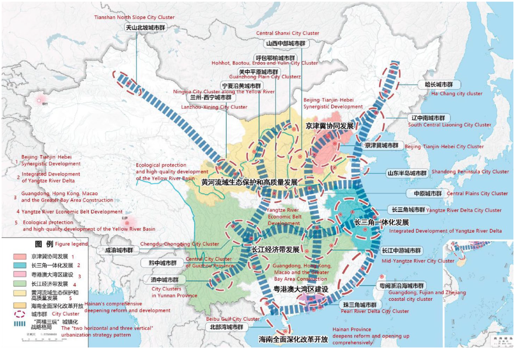
Spatial distribution of chéngshì qún/14th Five Year Plan (2021–2025).
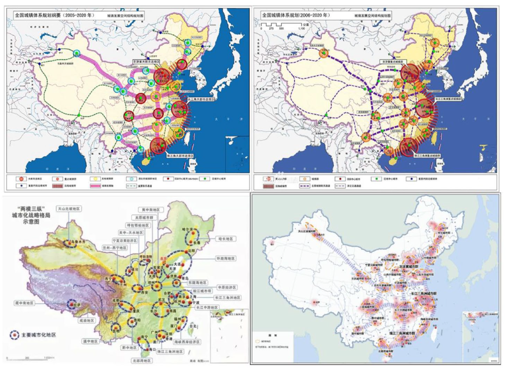
The spatial representation of China’s chéngshì qún in the 11th (top left – draft, top right – adopted), 12th (bottom left) and 13th (bottom right) Five Year Plans.
Mapping the political evolution of China’s chéngshì qún in the 21st century.
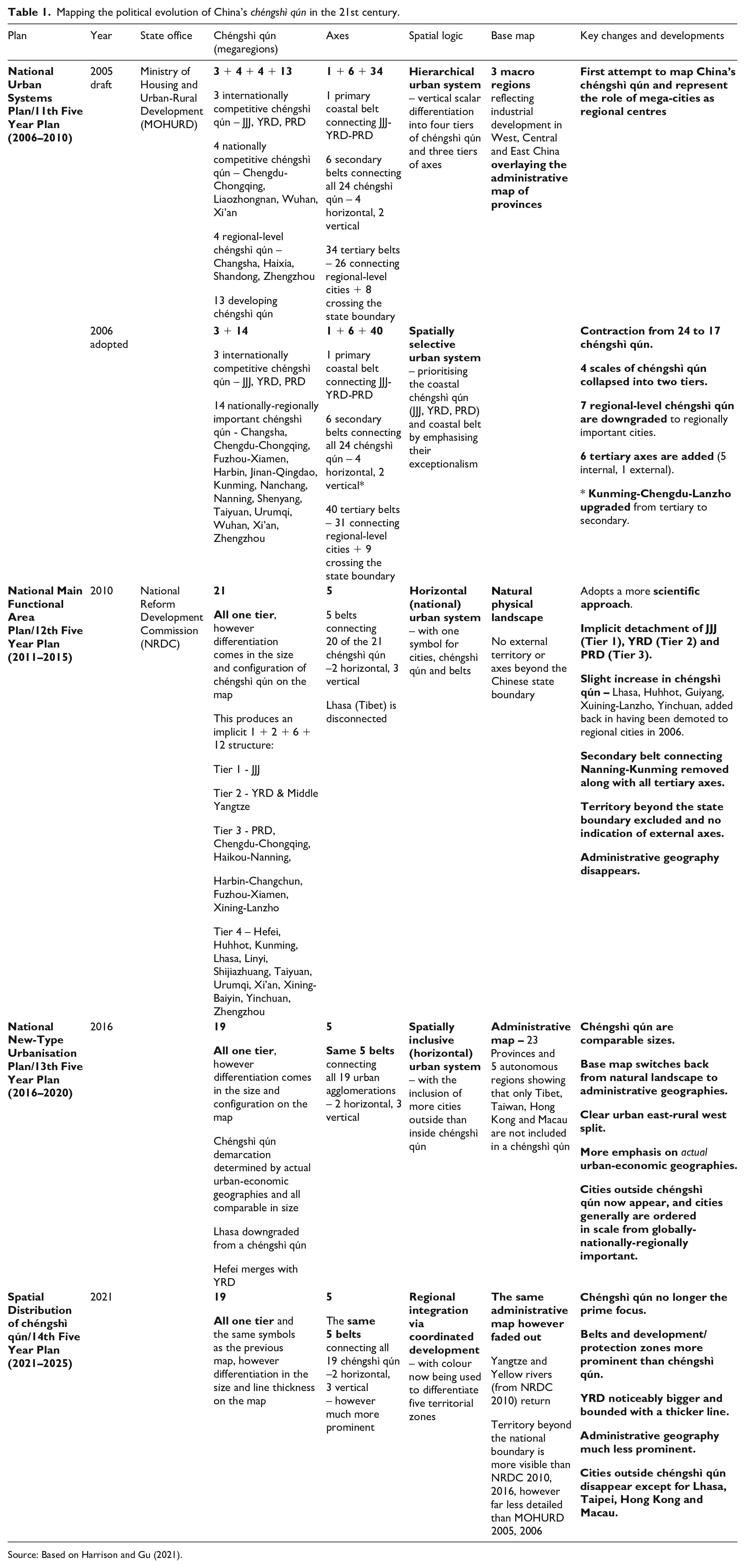
Source: Based on Harrison and Gu (2021).
Mapping China’s chéngshì qún: Where a picture paints a thousand words
Creating a design for a region is ultimately a political activity, an opportunity to marshal support for action. . . Constructing a durable coalition of interest rooted in a vision of the future is an essential prerequisite for action. (Hack, 2021: xvi)
In the 14th FYP (2021–2026), China’s commitment to ‘promoting the integrated development of urban clusters’ (cùjìn chéngshì qún rónghé fāzhǎn) is made visible with a single map detailing the spatial distribution of chéngshì qún (Figure 1). The map highlights 19 designated chéngshì qún, the overall pattern of two horizontal and three vertical development axes, and five development zones. The accompanying text provides some indication of the politics beyond the map: Taking the promotion of the development of urban clusters as the starting point, a strategic urbanization pattern of ‘two horizontal and three vertical’ will be formed in an all-round way, by upgrading the urban clusters of the Beijing-Tianjin-Hebei region, Yangtze River Delta, Pearl River Delta, Chengdu-Chongqing region, and the middle reaches of Yangtze River; developing the urban clusters of Shandong Peninsula, the coastal areas of Guangdong-Fujian-Zhejiang, the Central Plains, the Guanzhong Plain, and the Beibu Gulf; and fostering the urban clusters of Harbin-Changchun, Central and Southern Liaoning, Central Shanxi, Central Guizhou, Central Yunnan, Hohhot-Baotou-Ordos-Yulin, Lanzhou-Xining, Ningxia along the Yellow River, and the north slope of Tianshan Mountains . . . We will optimize the internal spatial structure of urban agglomerations, build ecological and security barriers, and form multi-center, multi-level, and multi-node network urban agglomerations. (CPC, 2021 – 14th FYP: Chapter 28 – Section I)
The politics emerges because the map presents the 19 chéngshì qún with very little indication that there is differentiation between them, however the narrative allocates chéngshì qún to three groupings requiring either upgrading, developing or fostering. In so doing, the static spatial representation of Figure 1 is complemented by a temporal recognition that chéngshì qún are at uneven stages in their development. This is further reinforced in the 14th FYP with the introduction, for the first time, of five development zones on to the map (Figure 1). Each zone promotes asymmetrical development: Beijing-Tianjin-Hebei emphasises ‘relieving’ Beijing of functions non-essential to its role as the capital city; Yangtze River Belt (which includes four chéngshì qún – Mid-Yangtze River, Chengdu-Chongqing, Central Guizhou, Central Yunnan) prioritises ‘ecological conservation’ and ‘boosting green development’; Guangdong-Hongkong-Macao Greater Bay Area is focused on ‘strengthening collaborative development’; Yangtze River Delta is for ‘accelerated development’; and the Yellow River Basin (which includes six small chéngshì qún – Lanzhou-Xining, Ningxia, Guanzhong Plain, Hohhot-Baotou-Erdos-Yulia, Central Shanxi, Shandong Peninsula) prioritised ‘ecological protection’ (CPC, 2021: Chapter 31).
At this point, many researchers move on from discussing the mapping of chéngshì qún because their primary focus and interests lay elsewhere (e.g. for Li and Jonas, 2022, it is the urban question; for Wu, 2015 it was urban and regional planning). From this perspective, the map is mobilised to contextualise other foci rather than being the object of research. Therefore, it is only necessary to engage with the current mapping of chéngshì qún. Our argument is that bringing the temporal to the fore, and making the mapping of chéngshì qún the object of research, we can observe the politics of megaregionalism in urban China. In practical terms, this is enabled by comparing the current mapping of chéngshì qún with previous iterations of the same policy map (Figure 2). By tracing the evolution of megaregionalism more detail pertaining to the politics of megaregionalism emerges (Table 1).
In a Chinese context, the age of megaregions owes much to politics. Chéngshì qún were existing and emergent geographies long before the 2001 National People’s Congress confirmed that urbanisation would be a central strategic priority in the 10th FYP (2001–2005). This was then followed in the 11th FYP (2006–2010) by statements affirming chéngshì qún as the territorial configurations from which China’s urbanisation ‘will primarily come’ (Ning et al., 2020). Affirmation of the critical role of chéngshì qún and urbanisation for China’s transition into a more affluent society followed with the establishment of the national New Urbanisation Plan (NUP, 2014–2020) (Chen et al., 2016, 2018). As Yeh et al. (2020: 3) observe, ‘in the past two decades these regions have undergone profound transformation’ and this owes much to chéngshì qún being ‘put at the forefront of policy debates in China’.
At its broadest several aspects surrounding the politics of megaregionalism come to the fore. First, the maps increasingly hide uneven development and scalar hierarchy. From the different symbols for chéngshì qún in the 11th FYP maps, a single symbol for all chéngshì qún is adopted along with a gradual flattening of the spatial hierarchy by representing chéngshì qún to be of similar size. China is not unique in this. Other countries experiences are similar as the initial economic logic for spatially selecting large urban agglomerations is made more politically palatable over time by presenting megaregionalism in policies as more spatially inclusive. Adopting a more balanced approach to developing chéngshì qún is further evident as recognition grows of the negative effects of deteriorating environmental conditions and intense global competition on the three coastal chéngshì qún, which is part of the reason for China’s move away from setting explicit growth focused targets in the 14th FYP.
Following several changes between the 11th and 12th FYP maps there is consolidation in the 13th and 14th FYP around 19 chéngshì qún and 5 belts. The NUP effectively gave statutory status to the layout of chéngshì qún because since entering the 13th FYP and NUP era, China has established individual development plans for each chéngshì qún and seen the completion of the national ‘4 + 4’ high-speed rail network (2008–2017) connecting the chéngshì qún. Stability and consolidation over the layout serves to effectively close down often distractive discussions over definition, delimitation and designation, opening the way for what the central state has been keen to promote since the 13th FYP which is a ‘people-centred’ approach to improving liveability and wellbeing in a modern and prosperous China.
This said, there has been notable push back in the 14th FYP. The more scientific approach adopted up to the 13th FYP policy map (see Fan, 2022) has been reversed – at least in the policy map – by removing actually existing urban geographies and downplaying of administrative boundaries in the 14th FYP. Furthermore, several ideas appear before quickly disappearing. For example, the role of cities outside chéngshì qún appear prominently in the 13th FYP but disappear completely from the 14th FYP. Politics is key because the 13th and 14th FYP align with the beginning and end of the NUP cycle (2014–20) – the NUP restricted cities with populations over 5 million and opened smaller cities to rural migrants, hence smaller cities appear on the 13th FYP map. More significantly, the underlying base maps change significantly in each FYP, moving from East-Central-West division (11th FYP) to the natural landscape (12th FYP), to administrative geographies (13th FYP) and, most recently, to a fading-out administrative geography overlain with five development zones (14th FYP).
Finally, for this illustrative purpose, critical questions begin to emerge around potential contradictions between the politics of megaregionalism and the wider state spatial project in which the Chinese state is mobilising chéngshì qún. For example, the Belt and Road Initiative was launched by President Xi Jinping in 2013 as China’s flagship global infrastructure development strategy for promoting economic development and interregional connectivity at an international scale, and yet, since the 12th FYP (2011–2015) the axes for infrastructure development, economic development and interregional connectivity between chéngshì qún stop before the national border.
The wider implication of all this is the way it reveals the mobilisation of chéngshì qún by the Chinese state as a key political tool in the pursuit of its wider state project over the past two decades. What also emerges is a constant balancing act. The spatial balancing act involves attempting to make spatial priorities which often overlap, compete, contradict appear complementary in each iteration of the policy map. The temporal balancing act – hitherto often overlooked – involves balancing continuity and change. Continuity comes from the need to establish consensus and build stability for chéngshì qún as a central pillar of urban planning in China. Change comes from the need for chéngshì qún policies to demonstrate agility, a capacity to flex and bend to align with the shifting contours of China’s political and economic programme.
Moving megaregional research forward: A research agenda based on thesis-antithesis-synthesis
With the launch of this new journal, we take this opportunity to outline an agenda for future research into the changing dynamics of urban China in an emerging ‘world’ and ‘age’ of megaregions. Inspired by Hegel’s thesis-antithesis-synthesis approach, our research agenda for megaregions takes the form of statements which are presented as modern theses. These are then countered by antitheses, an alternative view which provides ample scope for further research into urban China. Each thesis-antithesis statement is grounded in what we have learned from analysing the five policy maps visualising chéngshì qún in the previous section. Therefore, this thesis-antithesis list is not designed to be exhaustive, nor to be exclusive to researching urban China. Rather, the aim is to open research conversations about how we come to understand China’s chéngshì qún, urban China and megaregions more generally. We conclude by arguing that this challenge can only be met through synthesis.
1. Megaregionalism as spatial. . .or the time of megaregions?
Thesis: Megaregions are a spatial concept. Megaregions are framed around their importance as spaces of economic, political, social, environmental activity. Much energy should therefore be devoted to mapping megaregions and discussing, as this paper has, what does (not) go ‘on the map’. The result is increasingly sophisticated mappings of the spatial form and function of megaregions (e.g. Nelson and Rae, 2016; Taubenböck and Wiesner, 2015), but also extensive discussion about official and alternative maps for mobilising megaregions in spatial policy and spatial planning. In the case of China, for example, despite a decade whereby 19 chéngshì qún are officially recognised, in a recent collection of work on megaregion development Ning et al. (2020) identify 13 chéngshì qún, Yang et al. (2020) nine 9 mature and 11 developing chéngshì qún, while Yeh et al. (2020) separate out a group of ‘super’ chéngshì qún which are anchored by at least one mega-city with a 10m+ population (see also Yeh and Chen, 2020).
Antithesis: Megaregions have long been important spaces. By focusing on megaregions as a spatial concept researcher’s often overlook, or certainly downplay, the temporal dimension of megaregionalism. Focusing on the evolution of megaregions, rather than getting swept along with the idea that megaregions are somehow a new phenomenon or planning idea, requires more than a passing acknowledgement of the longer history of megaregional thinking. This requires understanding the continuities of megaregional thinking vis-à-vis claims to newness. In China continuity is now coming from stability in the layout of chéngshì qún (13th and 14th FYP), while the need for a qualitatively ‘new’ vision for each FYP is represented by the unique features which attract attention in each map (e.g. cities outside chéngshì qún in the 13th FYP, development zones in the 14th FYP).
2. Megaregions as economic powerhouses. . .or megaregionalism as political projects?
Thesis: Megaregionalism is about economic processes. Proponents of megaregions point to the economic logic surrounding agglomeration, capital accumulation and competition as the hallmarks of global neoliberal capitalism. This, they argue, gives megaregions the competitive advantage over other spatial units owing to the scale of agglomeration and density of activity taking place within them. The 11th FYP is indicative of this economic logic providing the starting point for megaregionalism, while the 13th FYP reviving the agglomeration idea demonstrates that while the narrative might soften the competitiveness argument always remain present.
Antithesis: Megaregionalism is about political processes. Here, political actors quickly recognise the economic logic behind megaregions being important for securing competitiveness in the global economy. They then mobilise to create the conditions necessary for their cities and regions to be strategically positioned to capitalise of this perceived competitive advantage, and arguably capture the process. In this way, political processes are critical to any account of urban-economic development, and megaregion development cannot be seen as happening at the expense of the state, rather it is being orchestrated and mobilised on behalf of the state. This is clearly claimed in the latest FYP: We [the Chinese state] will enhance the roles of mega cities in global resource allocation, in driving scientific and technological innovation, and in leading the development of high-end industries, ensuring that mega cities take the lead in forming an industrial structure with modern service industry as the mainstay and advanced manufacturing as the prop, and enhance their overall capacity and international competitiveness. We will continue the integration of urban areas and industries and improve the functions of new suburban cities to realize multi-center and cluster development. (CPC, 2021 – 14th FYP: Chapter 28 – Section III)
3. Megaregions as winners. . .or megaregions not being losers?
Thesis: Megaregionalism is focused on securing competitive advantages, both politically and economically, in an increasingly competitive global economy. Much of the rhetoric focuses on what it takes to ‘win’ and which places are ‘winners’ in the everchanging geoeconomic and geopolitical landscape. Megaregions are the winners. Being ‘on’ the map of megaregions is to be associated with the boosterist claims that these are the place you need to live and work (Florida, 2009). In China, the 14th FYP explicitly reinforces this message when stating how the focus will be on ‘areas that possess economic development advantages, such as central cities and city clusters [chéngshì qún]’ as the ‘key drivers of quality-oriented development’ (Chapter 30 – Section II).
Antithesis: Megaregionalism is mobilised by political actors fearful of being left ‘off the map’ of megaregions. Megaregionalism becomes a defensive, as opposed to offensive, move by political actors. It is therefore an attempt to demonstrate and project to others that if megaregions are the competitive territories, we are included in that. The defensive nature of megaregionalism is evident in the US, where Ross (2009) explains how the Regional Plan Association’s America 2050 megaregion initiative was sparked by concerns that the US was being left behind by the infrastructure investment going into high-speed rail, connecting up major cities and regions across Europe and China. In the context of China, an alternative view would recognise that the 2001 championing of urbanisation and chéngshì qún came in the immediate aftermath of the 1997 Asian financial crisis. Moreover, Zhang and Wen’s (2022) account of the rise of Chengdu under the Belt and Road Initiative openly discusses how the reshaping of the state-finance-infrastructure nexus is anchoring of massive infrastructure investment as part of state-sponsored chéngshì qún development and ‘crisis driven state restructuring’. This raises important questions about the degree to which megaregionalism was mobilised to secure competitive advantages vis-à-vis a crisis driven response to make China more resilient to external shocks (cf. Adler et al., 2020).
4. Megaregional planning and governance. . .or planning and governing megaregions?
Thesis: Megaregions are the ideal scale for planning and policy interventions in the 21st century. At one level, planning at this larger scale is attractive because it focuses on high-profile and large-scale investments, often relying on cutting edge technologies with an emphasis on speed. Most notable in this regard is the example of high-speed rail, which almost always goes hand in hand with megaregions. At another level, the idea of megaregional planning occupies a space which enjoys – at least in theory – some respite from the crowded landscape of institutions, logjam of policies and political infighting found at other levels. In China, the national ‘4 + 4’ high-speed rail network connecting 19 chéngshì qún was completed in the decade after Beijing-Tianjin became the first HSR link to open.
Antithesis: The US inventor, Thomas Edison (1847–1931) is reputed to have once said, ‘Vision without implementation is hallucination’. Vision and implementation is more evident in China than many other national contexts, particularly around major infrastructure; however, implementation is not without its challenges. Even around infrastructure there is competition and political tensions between cities within the same region (e.g. Li et al., 2023), and the lack of clear units and therefore institutional bodies operating at these geographies is widely discussed (Li and Wu, 2020; Wu and Zhang, 2022). At this present juncture, it may be more appropriate to talk speculatively about ‘planning and governing megaregions’ rather than about definitive ‘megaregional planning and governance’ (Harrison and Gu, 2021).
5. A megaregional orthodoxy. . .or the preserve of a few powerful voices?
Thesis: An orthodoxy surrounds megaregions being globalization’s new urban form, competitive territories par excellence and the ideal scale for planning-policy interventions. It is unsurprising then that actors are pursuing megaregional interests and there has been this wider interest among academics, researchers, policy thinktanks, journalists and extending as far as interested and curious citizens. This special issue and the launch of Transactions in Planning and Urban Research in this space is testament to the levels of interest.
Antithesis: The megaregion orthodoxy is being promulgated by a few powerful voices who have come to dominate the agenda, which is masking how megaregionalism has not affected much change. Wheeler (2015) talks here about how megaregionalism amounts to nothing other than a ‘business-as-usual’ approach to regional development, while Purkarthofer et al. (2022: 134) find that in a study of So-Cal (the Southern-California megaregion centred on Los Angeles), it ‘has not yet fully revealed its added value and thus remains a largely toothless spatial imaginary’ such that ‘the real need for cooperation and potential joint gains at this scale have not yet become apparent’ because it lacks the buy-in from a broader range of actors. It remains to be seen whether shifting from ‘growth oriented’ planning to more ‘people-centred’ approaches in China’s latest FYPs will pave the way for a broader coalition of voices to emerge.
6. Superstar megaregions. . .or a world of megaregions?
Thesis: A smaller number of ever larger megaregions are where people and socioeconomic activity concentrate. Urbanisation, on the one hand, is ensuring that there are an increasing number of places which are passing the traditional thresholds for megaregion status, and yet, on the other hand, the attention typically focuses disproportionally on a relatively small number of exemplars. In China there are 19 chéngshì qún recognised; however, the focus is almost exclusively on three – JJJ, Pearl River Delta and Yangtze River Delta (see 11th FYP). It is similar in Europe with London and Paris, in North America it is the Boston-New York-Washington DC, and in Africa the focus is Ibadan–Lagos–Accra. As noted above, this is then reflected in ‘super’ megaregions being identified (Yeh et al., 2020).
Antithesis: If megaregions are globalization’s 21st century urban form we should focus on all megaregions. In the case of China, what are we missing by focusing almost solely on developments in the three coastal megaregions. This is not to say that developments in other megaregions are being ignored; however, they remain relatively small seeds which have the light blocked by a great canopy of research on JJJ, Pearl River Delta and Yangtze River Delta. To illustrate this point, in a recent study of published research on urbanisation at a global scale, Kanai et al. (2018: 2580) revealed that ‘when we aggregated this group of “under-published” cities with populations of over one million by country, China (45). . .topped the list’. 2 Many of these cities are located in China’s 19 chéngshì qún. In this way, the policy maps in the 12th–14th FYPs reveal a politics of megaregional research where the policy attempts to shift the focus, however this has not been matched by where the focus of research is.
7. Learning from China’s chéngshì qún. . .or learning by looking elsewhere?
Thesis: Nowhere is megaregionalism more apparent than China and China leads when it comes to megaregion development. Even if your research, policy or article is not focusing on China itself, if it has a megaregional aspect then it is difficult to avoid ‘looking on’ at, and framing it in the context of, China and the development of chéngshì qún. In its own small way, this article is part of a much wider trend which is seeing more and more actors – be they researchers, planners, consultants, journalists, students – from the world over learning about, and increasingly from, China’s chéngshì qún.
Antithesis: Actors in China are ‘looking elsewhere’ to see what they can learn from what is happening in other contexts. For instance, in previous research on China’s chéngshì qún we observed mutual learning as actors in Europe and North America were seen observing developments in China while actors in China were reciprocating this by looking to see what they could learn from Western approaches to spatial planning, among other things (Harrison and Gu, 2021). Allied to this, China’s global infrastructure investment strategy – the Belt and Road Initiative – is increasing the Chinese state’s influence on global urban development beyond its state boundary. To fully understand urban China therefore requires us to increasingly look beyond China. Outside of this, there is an extra dimension which is the current increase in the focus of megaregional research on India (Mukhopadhyay, 2018; Ren, 2020; Williams et al., 2021) and Africa (Choplin and Hertzog, 2020; Schindler and Kanai, 2021). Rather than ‘looking on’ at China, our growing knowledge of the emerging world of megaregions presupposes the need to consider China in more comparative and comparable perspectives by learning from ‘looking elsewhere’.
8. A world of megaregions. . .or a world beyond megaregions?
Thesis: Megaregions are a ‘new form of urbanisation’ (Yeh et al., 2020) which are at the forefront of academic and policy debates. In China, the continued prominence of chéngshì qún in the 11th–14th FYP’s is indicative of how urbanisation and urban development in this century are going hand in hand with the rise of chéngshì qún.
Antithesis: UN-Habitat (2022: 116) reports that ‘most of the future urban growth will occur in small, intermediate and secondary cities’. From this perspective, megaregions are a story about past growth, much more so than current or potential future growth. Here, once again, the importance of combining the spatial and temporal comes to the fore. The temporal dimension is also important because a look back to the history of megaregions reveals that the term was initially mobilised in the first half of the 20th century by planners who saw these large urban regions as the tipping point in the evolution of cities from a dynamic of growth to a process of decline (Geddes, 1915; Mumford, 1938). In effect, megaregions were not something to aspire to, but the point at which cities had become too big. Indeed, for all the boosterist bravado surrounding megaregions, a lot of the focus today is on the problems presented, and faced, by megaregions – from outdated and inadequate infrastructure, contribution to and preparedness for the climate emergency, demand and supply of basic services, and so on. What we see in the evolution of how the central state is visually representing chéngshì qún in each FYP is less emphasis on the exceptionalism of chéngshì qún as a new form of urbanisation and more emphasis in presenting a vision which appears to show harmony between delivering competitiveness and development of chéngshì qún with ecological protection, spatially balanced, integrated and coordinated development.
Concluding comment – a case for synthesis
Taken together, we can see that there is much to debate around China’s chéngshì qún and megaregions more generally. This new journal is well-placed to be at the forefront of these research debates, with China’s chéngshì qún critical to understandings of urban China, but also to this ‘world’ and ‘age’ of megaregions. Perhaps the biggest challenge is that the thesis-antithesis research agendas presented in this paper should not be thought of as ‘either/or’ propositions. For as we have sought to demonstrate – by arguing the need to combine the spatial and temporal in research on megaregions in the first half of the paper – the way forward is to consider them as ‘both/and’ propositions. This requires synthesis of the individual propositions alongside how they come together to shape understandings of chéngshì qún, urban China and megaregions. Connecting the two parts of the paper is that a claim for synthesis in future research on megaregions is a claim for what the actors producing policy maps visualising megaregions must overcome each time they produce a new vision. Their task is to present a coherent vision, often overcoming seemingly competing, overlapping and contradictory propositions. It is for this reason that we believe there is much to learn about China’s chéngshì qún and megaregions from analysing how actors visualise and map megaregions.
Footnotes
Declaration of conflicting interests
The author(s) declared no potential conflicts of interest with respect to the research, authorship, and/or publication of this article.
Funding
The author(s) disclosed receipt of the following financial support for the research, authorship, and/or publication of this article: Financial support was provided by the National Office for Philosophy and Social Science Foundation, for the project ‘Research on the evolution characteristics of China’s urbanization spatial pattern since the 21st century’ (ID No. 22FGLB002, Hunan University).
Notes
Author biographies
John Harrison is Reader in Human Geography at Loughborough University, UK, and Visiting Professor at Hunan University, China. He is an editor of Regional Studies and Board Member and Trustee of the Regional Studies Association, as well as an Associate Director of the Globalization and World Cities (GaWC) research network.
Hao Gu is Lecturer in the School of Public Administration at Hunan University, China. He has published in journals including Urban Geography and Regional Studies on the urban geographies of studentification and planning megaregional futures.