
Abstract
Urban planning is a fundamental policy tool for countries to manage their land use and spatial development. As a nation’s economic, social and technological development undergoes changes, so does its planning system evolve dynamically to address the challenges of each era. In China, with the average annual urban population increasing 17.25 million since 1978, the spatial distribution of population and economic resources has undergone unprecedented great changes. The transformation of China’s planning system during the rapid and large-scale urbanization process could be divided into four stages: restoration of urban plan and establishment of the planning system (1978–1990); growth and development of the planning system under the market-oriented economic system (1990–2000); integration of urban and rural planning (2000–2010); exploring and forming a unified spatial planning system under the guidance of ecological civilization construction (2010–). This paper analyzes the characteristics of urbanization in China since the reform and opening up, the related era-specific issues and the policy responses, then elaborates the new landmark planning types that emerged in each stage, as well as summarizing the evolution process. There is no “standard, universal paradigm” in the process of building a country’s planning system, and no unchanging template or unified approach to achieving it.
Urban planning, which is targeted to formulate the spatial structure of urban and rural settlements, transportation systems and other infrastructures, public service facilities and industrial parks, is a basic policy tool for the spatial governance of central/local government on behalf of public interests, and also an important basis for the development and utilization of territorial space. While the levels of development and technological progress have been changing, the problems that need to be solved through planning and the methodologies to be applied will also change, which leads to a constant evolution of the planning system of each country. After 1949, under the planned economy system, New China established an annual plan and medium-long-term planning system for national economic development, as well as urban planning for large-scale industrialization construction (Yang, 2003). Due to the over-emphasis on heavy industry and the lack of attention to the development of urban infrastructure, China’s urbanization and industrialization was seriously mismatched, and the lagging of urbanization greatly affected economic development (Kirkby, 1985). Since the reform and opening up in 1978, China has embraced the largest urbanization process in terms of scale and speed in world history, and the spatial distribution of population and economic resources has undergone unprecedented drastic changes. From 1978 to 2021, China’s urban population increased by 742 million, an average annual increase of 17.25 million, which is unprecedented in the world. Over the past 43 years, China’s urbanization rate has increased by an average of 1.09 percentage points per year (Figure 1), 2.6 times the world’s average urbanization growth rate. In this process, new planning types have emerged and the planning system has been evolving. This paper introduces the changing role of urban planning in China and how planning has been used as a mechanism to achieve the national priorities of China since 1978. It illustrates both the “hot topics” and policy priorities of China over last few decades and how planning was used to implement them. Therefore it offers a grounded and practice-oriented narrative of China’s urban planning practice.
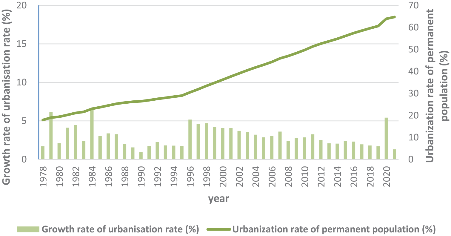
China’s urbanization growth in 1978–2022.
In general, the planning system from 1978 to 2021 can be divided into four stages (Figure 2): the initial recovery at the beginning of the reform and opening up period, a fundamentally complete establishment during the market reform, the urban-rural integration and regional coordination in the first decade of the new century and the comprehensive transformation towards ecological civilization in the new era. The changes in the planning system at different stages represent the different spatial governance needs of China’s development, and therefore form distinctive stage characteristics and typical cases. The evolution of China’s planning system is described in detail below in terms of four major stages.
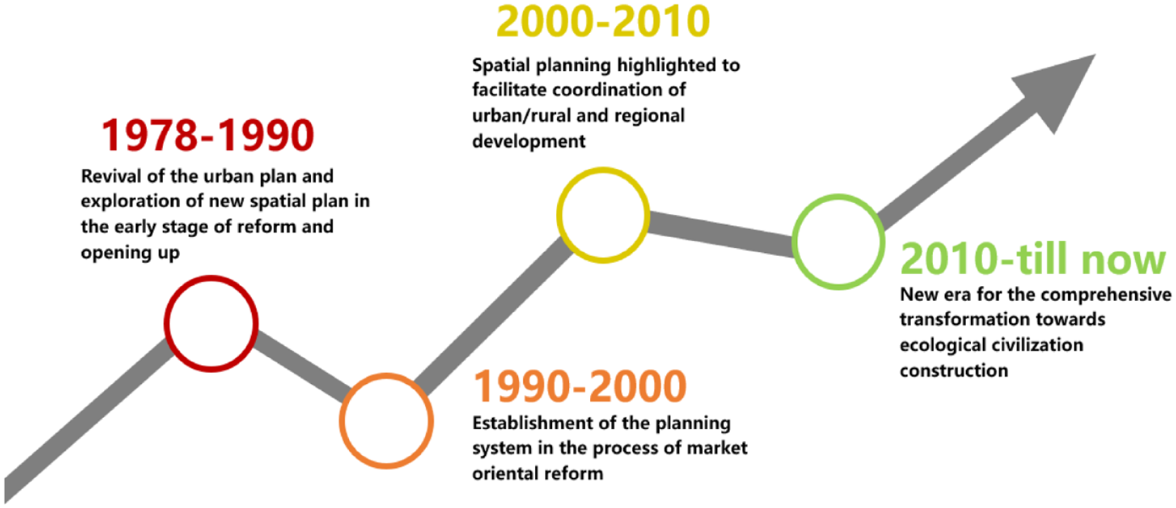
The evolution of China’s planning system.
Revival of urban planning and exploration of new spatial planning in the early stage of reform and opening up (1978–1990)
After the reform and opening up, the stagnant situation of China’s urbanization improved significantly. By 1990, China’s urbanization rate had reached 26.4%, up 8.5 percentage points from 17.9% in 1978 (Zhou, 2009). In the 1980s, reform of the family-contract responsibility system in rural areas greatly increased agricultural production and triggered increased trade between urban and rural areas. The central government also gradually opened the door to the flow of urban and rural labor. China’s cities were faced with a dilemma. On the one hand, they vigorously absorbed human resources to promote the development of urban economy; but on the other hand, urban construction was relatively backward, and there was not enough space and capacity to accommodate the huge labor force. As a result, the demand for construction land in towns, development zones, township enterprises and other areas increased significantly, and both the scope of urban planning and the national economic and social development plans were expanded, gradually drawing more attention to the development and regulation of national territory.
This period witnessed the comprehensive development of urban planning practice and legislation. In 1978, the National Urban Work Conference called for “raising awareness of the importance of urban construction” and “conscientiously doing a good job in urban planning”. In 1980, National Construction Commission held the National Working Conference on Urban Planning, and the leading position of urban planning in urban construction was determined in the conference. The master plans of special economic zones, economic and technological development zones, high-tech development zones and related cities were formulated in different places since then (Zhou and Gao, 2016). The main tasks of urban planning in this period were to adapt to the transition from the planned economy system to the commodity economy system after the reform and opening up, to meet the spatial needs of economic development, to improve the urban infrastructure that had long been in poor condition and to promote the comprehensive development and supporting construction of the city. By the end of 1986, the vast majority of cities had formulated urban master plans. With the establishment of special economic zones and development zones, the development of township enterprises and the entry of overseas capital, free use of urban land which lasted several decades was stopped, and regulatory detailed plans were explored in Guilin, Shantou, Guangzhou, Wenzhou and other cities (Huang et al., 2009). The “Urban Planning Law” was promulgated and put into effect in 1990, marking an important progress in urban planning practice and legal construction.
Territorial plans for regional development also arose. In 1981, the Land Resources Bureau was set up in the National Construction Commission and required all provinces to carry out a territorial plan (Hu, 2006). The purpose was to improve territory management and make plans for land use, land development, comprehensive development, regional development, environmental improvement and large river basins. In 1982, Territorial planning was piloted in six areas, including Beijing-Tianjin-Tangshan Region and the coastal areas of Ningbo, Zhejiang Province (Hu, 2006). During this period, some progress was made in the formulation of territorial planning. According to incomplete statistics, by the end of 1993, 30 provincial-level, 223 prefecture-level and 640 county-level administrative regions had carried out the formulation of territorial plans (Dong et al., 2017). In this period, the practice of territorial planning was conducted mainly based on the idea of “economic zoning” and productivity distribution. The content of territorial plans focuses on the distribution of productive forces, resource development and land consolidation, but tends to manage land resources from the perspective of planning, which is regarded as an important preliminary and basic work of national mid-long term development planning. Land use plans were being explored and developed to strengthen farmland protection. In the mid-1980s, with the development upsurge of township enterprises and the boom of development zones, large-scale occupation of cultivated land by urban construction resulted in increased pressure on grain production. In 1986, the state established the Land Administration Bureau and promulgated the Land Administration Law, which for the first time proposed that “people’s governments at all levels formulate a comprehensive land use plan”. In the following ten years, comprehensive land use plans at the national and local levels were formulated and implemented successively, which stipulated the direction of land use within the administrative divisions of the whole city. The main tasks of comprehensive land use plans in this period were to make overall plans for land utilization in various industries, strictly protect cultivated land and rationally develop reserve land resources. The key contents were the study of land carrying capacity, cultivated land development and management, and urban land prediction.
Establishment of the planning system in the process of market oriental reform (1990–2000)
After Deng Xiaoping’s southern tour in 1992, a wave of large-scale development and construction occurred throughout the country, especially in the eastern coastal areas. The “development zone fever” spread from coastal cities to the whole country, with a significant increase in foreign direct investment, rapid development of the private economy and the start of market-oriented reform of the urban land use system (Gu, 2015a). With the reform of the household registration system, urbanization has accelerated. From 1990 to 2000, China’s urbanization rate of the resident population increased by an average annual rate of 0.98 percentage points. The national urbanization rate exceeded 30% for the first time in 1996 and reached 36.2% in 2000. With the acceleration of urbanization, the problems that need to be solved by planning in urban development are becoming more and more complex.
In the process of market-oriented reform, the urban planning system has been further developed. In 1991, the second National Urban Planning Working Conference proposed that “urban planning is not entirely the continuation and embodiment of national economic planning, and cities, as the carriers of economy and various activities, will increasingly operate in accordance with the market” (Huang et al., 2009). In May 1990, The State Council issued the Interim Regulations concerning the Assignment and Transfer of the right to the Use of State-owned Land in Urban Areas, marking the establishment of the legal basis for the compensated transfer of State-owned land. In 1992, the Measures for the Compilation of Urban Planning established the content and requirements of the detailed controlled plans, and the compilation of the detailed controlled plans began to be carried out nationwide.
In 1994, after the central and local tax distribution system reform, local governments began to rely on land sales and stimulating the real estate market to increase fiscal revenue, and land expansion intensified both in urban area and development zones. In 1998, the state implemented the housing reform policy, stopped the distribution of housing in kind and gradually realized the monetization of housing distribution, and the commercial housing market developed rapidly. With the continuous progress of market-oriented reform, urban planning has been given great importance by local governments because of its role as an administrative tool to promote economic and financial growth (Dong et al., 2017).
Space is produced with both intention and destination. It is the product of political economy. The planning of modern economies tends to become the planning of space. People pursue profits through the production of space, and space becomes the focus of interest competition (Lefebvre, 1991). By allocating spatial resources, urban planning plays a guiding role in construction and serves local economic development. In this period, the city master plan focused on the rational spatial arrangement of various urban functions within the scope of urban planning areas (Shi, 2008). With the increasingly significant role of the market in resource allocation, urban development required more research on market rules, and more attention was paid to the research and analysis of the macro environment of urban development and the relationship between related cities. China’s planning industry has been highly prosperous in the market transformation period. Planning played a legitimate policy tool in ensuring economic growth, and strengthened the role of the country during market transformation, thus in turn enhancing its own status. (Wu, 2015).
The position of regional layout in the planning system became more valued based on differences in physical geography and development levels and the 7th Five-Year Plan divided China into three regions: eastern, central and western. In 1990, the Eighth Five-Year Plan put forward the development and opening up of the Yangtze River area, with Shanghai Pudong as the leading area, which became an important measure of regional layout in opening up. There are two regional layout tendencies in the Chinese planning system: one to promote the rise of large cities and the other to contain them, which, despite their role as economic growth poles, have had a negative role in exacerbating regional inequalities, governance challenges and social tensions through concentrated urban growth (Jaros, 2019). Thus the state tries to prevent top-heavy urbanization and promote regional balance and coordination through planning policies. During the 9th Five-Year Plan period, regional development layout attracted more attention with the aim of forming “a number of distinctive regional economic bodies”. Depending on the central city and traffic arteries, a number of cross-administrative economic regions were formed, including the Yangtze River Delta and areas along the Yangtze River economic belt, the southeast coastal economic zone and the Bohai economic circle, the Asia-Europe continental bridge, the Beijing–Kowloon railway economic belt and so on.
Planning has become an important measure to protect farmland. With the rapid economic development and urban expansion, the reduction of agricultural land, especially cultivated land, has attracted widespread attention. Contradictions between construction and conservation have been sharpening. As a policy tool to strengthen the protection of land resources, land use planning has received further attention. The Land Administration Law, revised in 1998, detailed the comprehensive land use plan, requiring “strict restrictions on the conversion of agricultural land to construction land, control of the total amount of construction land” and ensuring that “the total amount of arable land does not decrease”. This law strongly emphasized the protection of land, minerals, groundwater and marine geology. In 1999, the Outline of the National General Plan for Land Use was approved and implemented. By February 2001, 112 provincial and municipal comprehensive land use plans had been approved (Dong et al., 2017). The goal is the overall arrangement and layout of the development, utilization, governance and protection of land in space and time according to the requirements of the sustainable development of national social economy and local natural, economic and social conditions, and has become the institutional basis for sub-regions to supply construction land according to plan.
Spatial planning highlighted to facilitate coordination of urban/rural and regional development (2000–2010)
From 2000 to 2010, the urbanization rate of China increased by an average of 1.37 percentage points annually (Lee et al., 2013). In the new century, when formulating the “Tenth Five-Year Plan”, “actively and steadily promoting urbanization” was clearly proposed for the first time, and urbanization became a national strategy. After China joined the World Trade Organization in 2001, it quickly integrated into the world economic system, and the export-oriented processing and manufacturing industry expanded rapidly, followed by the large-scale entry of agricultural surplus labor into urban non-agricultural industries. In 2011, China’s urbanization rate reached an historic threshold, exceeding 50%. At the same time, with the deepening market-oriented reform, the government’s intervention in micro-economic activities had been significantly reduced, and economic regulation, market supervision, social management and public services had become the focus of government functions. The importance of planning became increasingly prominent, and the types and contents of planning have been expanded.
China’s urban governance and spatial planning system in the 21st century has continued to create a number of cities and regions with special economic status, such as the five special economic zones, the open coastal cities and the coastal economic development areas approved by the state, which have become hot-spots for economic growth and innovation, but have also led to uneven regional economic development. In the first decade of new century, spatial planning and economic development reforms have sought to change China’s cities and regions from the “special economic zone” to integrated development, and rural areas have also been benefiting from the planning reforms.(Gebhardt, 2018)
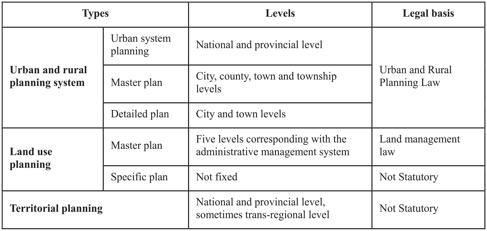
Evolution of urban planning into urban and rural planning
In 2008, the Urban and Rural Planning Law took effect, replacing the original the Urban Planning Law. The public policy attributes of urban planning have been significantly enhanced, involving different fields such as social economy, spatial layout, land use and ecological environment (Gu, 2015b), and the spatial scope of attention has also expanded from the inner city to the regional level (Shi, 2008). In addition to urban system plans, there are other new-type plans, such as strategic plans and conceptual plans, that focus on positioning and strategic measures of urban development from a macro perspective, and enrich the urban planning system by covering more comprehensive content and more diversified types.
For example, the Urban Master Plan of Nanjing (2011–2020) proposed prosperity, harmony, livability, good ecology, vitality and distinctive characteristics as the goal of modern city. It pays attention to the overall development of urban and rural areas, and implements unified urban and rural planning and management within the 6,582 square kilometers of urban planning area determined in the master plan. In order to meet the needs of urban construction, urban (town) plans are divided into master plans and detailed plans, and the latter are further subdivided into regulatory detailed plans and residential district detailed plans.
The inclusion of land policy in the macro-control toolbox
At the dawn of the new century, China’s urban planning and urban development were both undergoing new changes shaped by a combination of socialism, market reforms and globalization. The situation of local governments as promoters of growth gave them the ability to reap the benefits from redevelopment (Logan, 2002). After 2002, China’s economy entered a new round of rapid growth. In order to prevent the economy from overheating, since the second half of 2003, the credit gate was strictly controlled while central government had adopted strict land use planning, construction land use approval management, rectified the operation of the land market and strictly controlled the supply of new construction land, which has played a positive impact on restraining the excessive growth of investment. In 2006, the third round of land use plan revision put forward a “global, flexible and dynamic” development concept. In order to provide a basis for the division of the control index, and for the spatial layout of the allocation of construction land, the third round of land use plan revision developed methodologies including building intensive land use evaluation index systems from economic, ecological and social aspects, and conducting spatio-temporal analysis and analysis of land development potential in specific regions (Gu, 2015).
Taking the overall plan for land use of Nanjing for example, Nanjing has formulated three rounds and four versions of the overall land use plan, which were approved by the People’s Government of Jiangsu Province or the State Council in 1994–2017. The early land use planning of Nanjing built the framework of land use management in the whole city, providing the basis for implementing strict farmland protection system and a strict economic and intensive land use system. The land use planning after 2006 became more comprehensive, and studied it from economic, ecological, social and other aspects. It has played a positive role in land macro-control, protection of cultivated land and support development.
The appearance of Major Function-Oriented Zoning to establish order for national land development and protection
With rapid economic development, excessive competition among regions had led to increasing pressure on resources and environment, widening the development gap between urban and rural areas and creating other problems. It became urgent to establish an overall optimal new pattern of land development and protection based on local resource endowment and comparative advantages. Since 2001–2008, the central government launched series pilot projects of the territorial plan in Shenzhen, Tianjin, Liaoning, Guangdong, Fujian, Chongqing and Henan, to explore effective ways to optimize the spatial development pattern and enhance the capacity of territorial space management. Major function-oriented zoning, which was initiated by the National Development and Reform Commission, had become a significant practice in the field of national land plan, and one of key parts of the development planning system (Figure 3) in the new era. In 2006, the 11th Five-Year Plan proposed to “divide the national territory into four types of major function-oriented zones: optimized, prioritized, restricted and prohibited zones, adjust and improve regional policies and performance evaluation according to the Major Function-Oriented Zoning, standardize the order of spatial development, and form a reasonable spatial development structure” (Figure 4). In 2010, National Major Function-Oriented Zoning was officially released, which provided the management basis for formulating the spatial development layout of various types of plan such as development plan, regional plan and urban plan (Shi, 2008). In National Major Function-Oriented Zoning, the strategic spatial pattern of urbanization has been determined as “two horizontal and three vertical” at the national level.
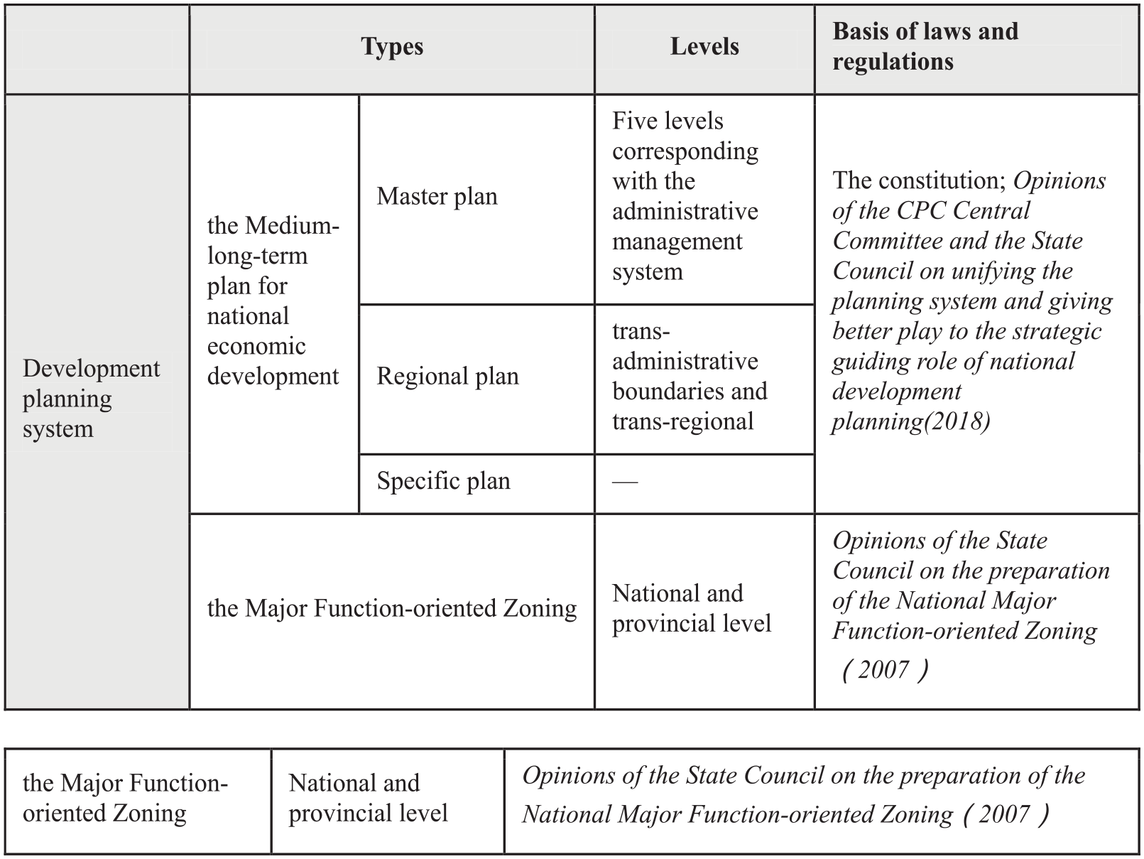
Types and levels of the development planning system.
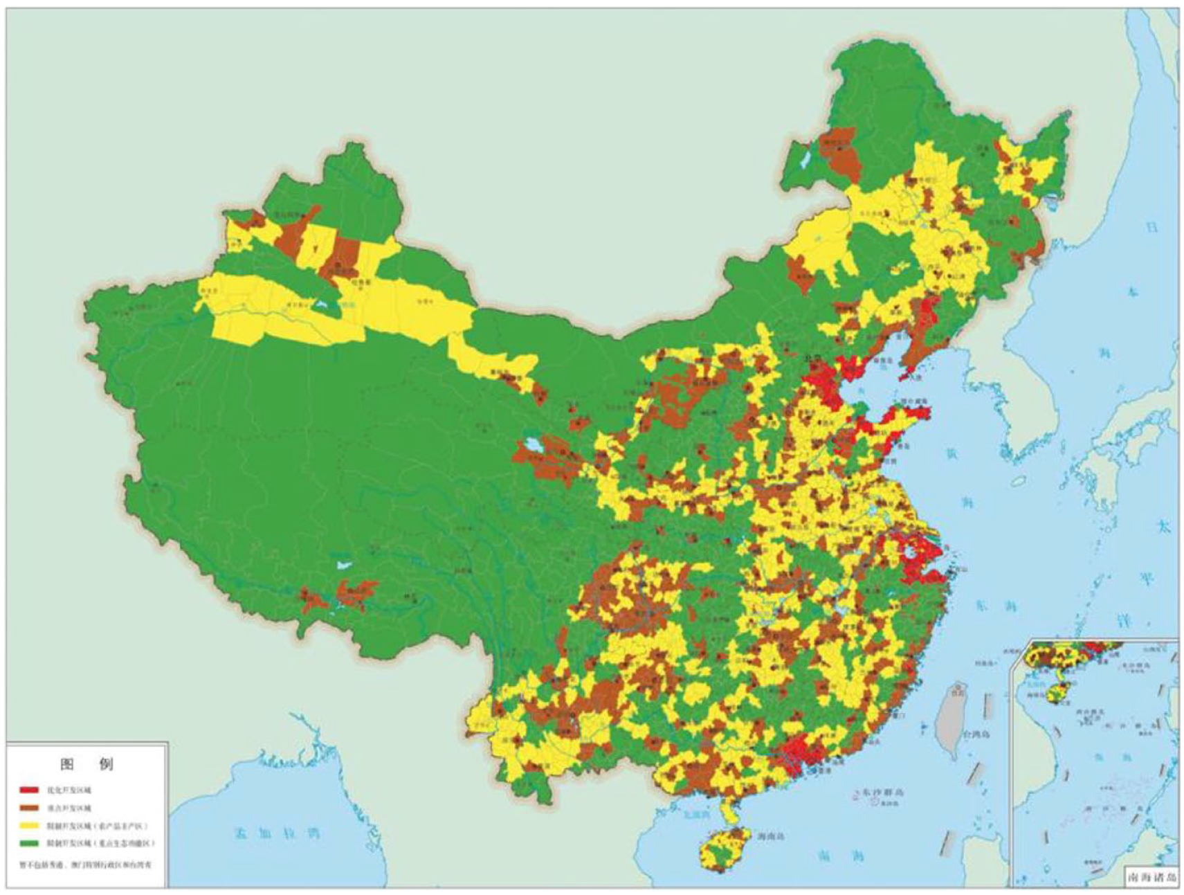
Territory space division of national level Major Function-Oriented Zoning.
2010 marks the watershed when China’s urbanization rate exceeded 50%. In 2010, China’s urbanization rate had risen to 49.7%, and in 2011, the urbanization rate had reached 51.27%. After this, the population began to concentrate and accelerate its flow to large cities and megacities, while the flow of population to small and medium-sized cities was relatively slow. The rapid development of urbanization in China has had a huge impact on urban housing, land supply, economic development and fiscal growth. In order to support the rapid urbanization process, the urban planning system during this period is also accelerating its transformation.
A new era for the comprehensive transformation towards ecological civilization construction (2010–)
As a result of the continuing rapid economic growth and the deepening market-oriented reforms, urbanization in China has entered an accelerating stage. In 2007, the 17th National Congress of the Communist Party of China raised a new type of urbanization with Chinese characteristics. In 2013, the Central Committee of the Communist Party of China (CPC) held a historic Conference on Urbanization, emphasizing that urbanization is the inevitable way to modernization, and promoting urbanization as an important way to solve the problems of agriculture, rural areas and farmers, a strong support for coordinating regional development, and an important starting point for expanding domestic demand and promoting industrial upgrading. Afterwards, the first National New Urbanization Plan 2014–2020 was issued. The plan proposed to follow a new urbanization path with Chinese characteristics, which was put forward as a “people-oriented, four development synchronization, optimization of deployment, ecological civilization and cultural inheritance”. The Central Urban Work Conference held in 2015 pointed out that urban development was an important engine for modernization and highlighted the importance of respecting the law of urban development. Under this background, the transformation of urban and rural planning is further accelerated.
Local governments, actively explore the concept of “multiple-plan integration”
With the increasing varieties of plan (Figure 5), contradictions and mutual constraints among various plans become more eminent gradually, affecting the unity and effectiveness of space policies (Lian and Zhang, 2018; Wang and Liu, 2012; Wu, 2019). After 2008, Guangzhou, Xiamen and other coastal cities pioneered exploring methodology of integration different plans, to alleviate the contradiction between land supply and demand as well as the shortage of construction land indicators. This multi-plan coordination work, in essence, is not a compilation of different plans, but a technical and functional coordination with strong local sense.
The multiple planning types in the new ear (before 2018).
Since 2014, “Multiple-plan integration” has entered the pilot stage at the local level under the guidance of state departments. The National Development and Reform Commission, the Ministry of Housing and Urban-Rural Development, Ministry of Land and Resources and the Ministry of Ecological Environment have carried out 28 cases of “multiple-plan integration” based on development plan, urban plan, land use plan and other departments respectively, formulating the unified plan led by the department and coordinating with other plans accordingly. The exploration of a “united multi-plan” at this stage can be interpreted as a new plan in addition to all other master plans, with an essence being to solve the problems of content cohesion and coordination among the various plans (Zhang and Lian, 2019; Wu et al. 2019a).
The pilot work achieved some consensus in implementing the spatial boundaries of various control elements, and recognized the practice of delimiting the three main control lines of ecological protection, permanent farmland and urban development. This consensus was also recorded in the task requirements of the 19th National Congress report. The work of “multiple-plan integration” emphasizes the assistance of information technology such as geographic information system, which effectively promotes the precise positioning of the control objectives of land space use.
The central government promotes the formulation and implementation of comprehensive territorial spatial plans
In 2012, the 18th National Congress of the Communist Party of China released tasks of ecological civilization construction in the overall layout of socialism with Chinese characteristics, and clearly put forward the development goal of building a resource-saving and environmentally friendly “beautiful China”. Green and low-carbon development was given unprecedented attention and has become an important part of the new development concept put forward since then. In 2013, Decision of the Central Committee of the Communist Party of China on Several Major Issues Concerning Comprehensively Deepening the Reform, which is approved by the 3rd session of the 18th Plenary of the Communist Party of China, put forward the goal of modernizing the system, the capability for national governing and the quest to establish a unified national spatial planning system. Spatial planning played the key role in the scientific and effective implementation of space governance. Building a spatial planning system was listed as one of the eight tasks in building an ecological civilization system in the Overall Plan for Reform of the Ecological Civilization System, released in 2015. The reform and exploration of spatial planning was promoted from fragmented departments to the whole, aiming to build a unified expression of spatial development and protection order based on the scientific evaluation from the background of resource and environment bearing and land development suitability (Hu et al., 2023). It should be pointed out that there are two different understandings of territorial space for regions or elements from the vision of development or protection: “disordered development, excessive development and decentralized development” are the overall issues of regional development; “high quality cultivated land and ecological space occupation” is an important issue for land use at the local level (Lin et al., 2018).
The main work is to carry out the basic dual evaluation, including evaluation of resources and environment bearing capacity, and evaluation of land space development suitability on the basis of the evaluation contents, indicators and standards. Nanjing has integrated all the elements of the dual evaluation into five steps – preliminary work preparation, single-factor evaluation, integrated evaluation, comprehensive analysis and delineation of the “three lines” – and has implemented these elements in Territorial Spatial Master Planning of Nanjing (2021–2035) (Figure 6).
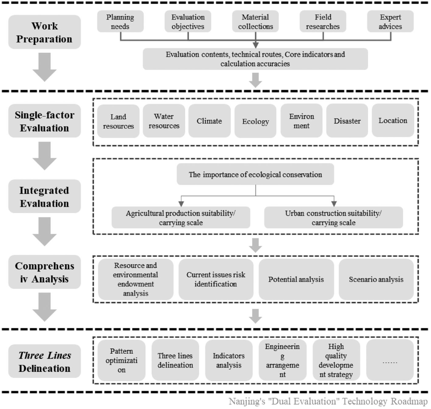
“Dual evaluation” technology guidance.
In order to systematically plan a new pattern of high-quality land space, build an open and coordinated regional development pattern, a systematic and resilient ecological agricultural pattern, and an efficient and balanced urban space pattern, the planners evaluated the importance of ecological protection and the suitability of planting production.
In the plan, the compilers evaluated the maximum bearing scale of cultivated land and the maximum reasonable scale of urban construction from the perspective of land and water constraints, and took the minimum value of the evaluation results as the maximum reasonable scale of cultivated land and the maximum reasonable scale of urban construction according to the short board principle.
Scientific identification of important ecological space and general ecological space is carried out through detailed identification of natural ecological space and evaluation of ecological protection importance of water source protection area, flood regulation and storage, river and lake shoreline protection, natural relics, natural landscape and other elements.
Based on these evaluation results, the territorial space of the whole region can be divided into the following seven types of first-level planning zones, namely, ecological reserve zone (terrestrial and marine natural areas with special important ecological functions or ecologically sensitive and fragile areas that must be strictly protected), ecological control zones (except the ecological protection red line, terrestrial and marine natural areas that need to be preserved, ecologically conservation strengthened and construction activities restricted), farmland conservation zones (the area where most land is high production farmland and should be strictly protected permanently), as well as urban development zones (the scope urban development could reach in the future), rural development zones (outside the farmland protection zone, the area mainly for meeting the needs of agricultural development such as agriculture, forestry, animal husbandry and fishery, and the concentrated living and production of farmers), marine development zones (sea areas where centralized development and utilization activities are allowed, and uninhabited islands where moderate development and utilization activities are allowed) and mineral-energy development zones (important continental mining areas) (Ministry of Natural Resources of the Ministry of Natural Resources of the People’s Republic of China, 2020).
In Territorial Spatial Master Planning, another important task is to delineate the “three zones and three lines” (the ecological zone, agricultural zone and urban zone; ecological red line, urban development boundary, and permanent farmland red line), which is crucial for optimizing the land development pattern and urban-rural spatial structure, and ultimately forming a unified spatial planning map. The “three zones” highlight the division of dominant functions, covering every inch of the territory, and are not interlaced with each other; while the “three lines” focus on rigid control of boundaries. Horizontally, the “three zones and three lines” define the boundaries and bottom lines of various special plans. Vertically, through the hierarchical transmission and implementation of territorial spatial planning from top to bottom, the implementation, modification and approval procedures of the “three zones and three lines” will be included in the unified use control management of territorial space. Overall, as an important means of territorial space regulation, the scientific delineation of the “three zones and three lines” is the key to formulating territorial spatial planning, and also a vital measure to guide the rational allocation of land resources, and promote high-quality development through high-quality land spatial layout. (Ministry of Natural Resources of the Ministry of Natural Resources of the People’s Republic of China, 2019).
Taking the Territorial Spatial Planning of Henan Province (2021–2035) (first draft) as another example, the plan clearly emphasizes the building of the basic line guaranteed development safely. It gives priority to delimiting the protection red line of cultivated land and permanent farmland, adheres to the principle that the existing cultivated land be fully included and protected, and located on the ground. Scientific delimitation of the ecological protection red line will include integrated and optimized natural reserves, areas with extremely important ecological functions, ecological sensitive areas and ecological areas with potentially important ecological values into the ecological protection red line. It aims to delineate the urban development boundary as a whole, avoiding restrictive factors such as the bottom line of resources and environment, disaster risk, and historical and cultural protection in order to reasonably determine the scope of the urban development boundary, and to manage the size and layout of cities and towns. By clarifying the boundary lines between development and protection, it helps to achieve the goal of promoting intensive and efficient urban construction.
Since 2018, a unified plan system has been gradually established, which was guided by the national development plan, based on spatial plans, and supported by various special and regional plans. Spatial planning, including the Major Function-Oriented Zoning plan, land use plan, and urban and rural plan, has been integrated into a unified territorial spatial plan, thus fulfilling the integration of multiple plans into one (Wu et al. 2019b). The types and levels of territorial spatial planning system can be roughly divided into three categories and five levels (Figure 7). Before December 2022, 28 provinces and dozens of cities and counties have enacted their territorial plans, with the national territorial plan on the horizon.
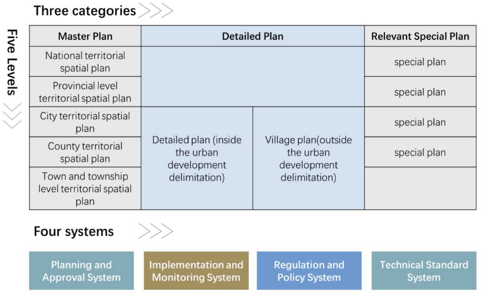
Basic structure of territorial spatial planning system after the reform.
At the provincial level, territorial planning is more coordinated, both as an implementation of the national plan and as a guide to the plan at the city and county level. Taking the Territorial Spatial Planning of Shandong Province (2021–2035) (first draft) in 2021 as an example, this paper provides a brief summary of the characteristics of provincial territorial plans. Firstly, the provincial territorial planning highlights strategic objectives, clarifying the strategic positioning and target vision of development based on the implementation of the main functional zoning pattern. Secondly, the provincial territorial spatial planning emphasizes integrated planning, by combining the protection and use of natural resources and the optimization of territorial space development on the basis of “Multiple-plan Integration”. Thirdly, provincial territorial spatial planning attaches importance to binding restrictions, through the establishment of mechanisms and the improvement of policy systems. The control of the use of territorial space in the whole area and all elements will be achieved. Finally, provincial territorial spatial planning should lead the coordinated development of the region, with central cities leading urban clusters and urban clusters forming economic circles to achieve high-quality development throughout the planning range.
At the city and county level, the plan lays more emphasis on implementation, and thus the detailed plan, village plan and the construction project schemes and action plans play a more significant role at this level.
The implementation of regional plans and metropolitan area development plans
Central cities, metropolitan areas and urban agglomerations are becoming the main spatial forms that carry the elements of development. By the end of 2020, there are 7 megacities with population over 10 million, 14 metropolises with population over 5 million and another 84 large cities with population over 1 million in China. The 19 urban agglomerations identified in the National New Urbanization Plan (2014–2020) carry more than 75% of China’s urban population and contribute more than 80% of China’s GDP. The international competitiveness and influence of the three major urban agglomerations of Beijing-Tianjin-Hebei, Yangtze River Delta and Pearl River Delta have been significantly improved. The general railway network and expressway network basically cover cities with a population of more than 200,000 and the rapid railway network basically covers cities with a population of more than 500,000. The level of integration and cooperation within urban agglomeration in key areas such as infrastructure, unified market, industrial development, ecological environment and public services has been significantly improved, and the ability to absorb population, industry and various innovative elements has been continuously improved.
A metropolitan plan belongs to regional planning. Regional planning focuses on implementing major regional strategies and coordinating the resolution of major issues across administrative regions, and is an important basis for guiding the development of specific regions and formulating relevant policies. One of the characteristics of a metropolitan area is that it goes beyond the administrative jurisdiction of the core city, and the planning of a metropolitan area is also a coordinated planning across administrative regions (Zhang and Lian, 2021). Therefore, from this perspective, urban agglomeration planning should belong to regional planning. Also, metropolitan planning is a special type of regional planning. The rules of the metropolitan planning have a strong spontaneous characteristic, that is, they are led by core cities and jointly initiated by towns within the area.
As early as in the 13th Five-Year Plan, China has clearly proposed that new urbanization should take urban agglomerations as the main spatial pattern. In 2022, The Implementation Plan of New Urbanization during the 14th Five-Year Plan, which places emphasis on optimizing the spatial layout and form of urbanization, has been officially approved by the State Council. In response to the implementation of major national territorial strategies, and to promote the development of urban agglomerations by categories, many regional plans have been put formulated. For example, the Master Plan for the Construction of Chengdu-Chongqing Twin Cities Economic Circle was issued in 2021. This plan provided guidance for the region to play an important strategic role in the overall national development, and formulated the “assignment book” and “construction drawing” for the high-quality development of Chengdu-Chongqing twin cities.
Also, to cultivate modern metropolitan areas in an orderly manner, the National Development and Reform Commission issued the Guiding Opinions on Cultivating and Developing Modern Metropolitan Areas in 2019. In the unified planning system, regional planning focuses on the implementation of major regional strategies and the coordinated solution of major trans-administrative-boundary problems, which is an important basis for guiding the development of specific regions and formulating relevant policies. Metropolitan area planning also coordinates planning beyond the administrative jurisdiction of the core city, so from this perspective, metropolitan area planning should belong to regional planning. The planning of the metropolitan area has a strong spontaneous feature, that is, it is led by the core cities and jointly initiated by the cities and towns within the area, and it is mainly to coordinate the development within the area. A number of metropolitan area development plans such as Nanjing, Fuzhou, Chengdu, Changsha, Zhuzhou, Xiangtan and Xi’an were released and implemented.
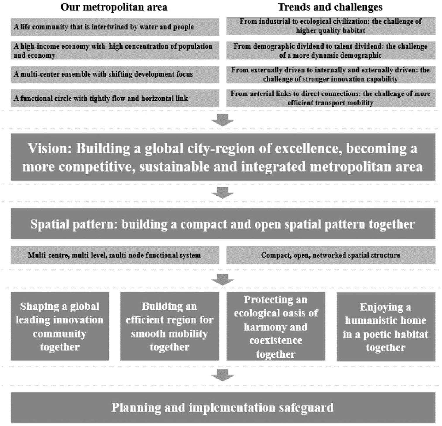
The Chengdu Metropolitan Area Development Plan, officially issued by the People’s Government of Sichuan Province in November 2021, is the third metropolitan area plan approved at the national level and the first one in the central and western regions. The plan proposes eight major tasks: optimizing the development layout, accelerating the integration of infrastructure into cities and networks, synergistically improving the level of innovation-driven development, jointly building modern industrial clusters, improving the level of openness and cooperation, promoting the convenient sharing of public services, promoting the co-protection and co-governance of the ecological environment, and deepening the reform of institutional mechanisms. The plan proposes to promote the coordinated construction of major platforms and jointly build a high-quality development space carrier. It is the core value of the development planning of the metropolitan area to give full play to the intra-city effect based on the scale effect and scope effect. The plan proposes to promote the coordinated construction of major platforms, including jointly building the Chengdu–Deyang Port Economic Industrial Belt, Chengdu–Ziyang Airport Economic and Industrial Zone, and Chengdu–Meizhou High-tech Industrial Belt (Figure 8), together providing a high-quality development space carrier for the metropolitan area.
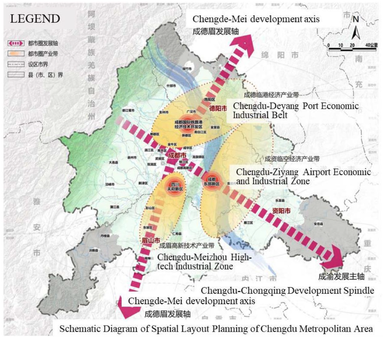
Schematic diagram of spatial layout planning of Chengdu metropolitan area.
Since 2020, the National Development and Reform Commission has promoted the formulation of many metropolitan development plans; The Ministry of Natural Resources has initiated the preparation of the industry standard “Regulations for the Compilation of Metropolitan Territorial Spatial Plans”. In order to improve the territorial space management and control system of the metropolitan area, the local governments spontaneously jointly prepare and format the metropolitan territorial spatial plans, which can effectively solve the problem of coordinated management of land space across administrative regions (Ministry of Natural Resources of the Ministry of Natural Resources of the People’s Republic of China, 2021). The coastal region has responded quickly to the new urbanization plan requirement and started to act. The Yangtze River Delta, leading the country in economic and social development, has achieved remarkable results in its integrated development. To promote higher-quality integrated development from a higher starting point, in 2019, the Outline of the Plan for Integrated Development of the Yangtze River Delta Region, which provides a programmatic guiding for regional integration development, was issued by the central government.
During the 13th Five-Year Plan period, regional development was mainly carried out around urban agglomeration, but its scope was too large, there was a lack of implementation grip and the “hollowing” phenomenon of construction was more prominent. Compared with urban agglomeration, the spatial scope of metropolitan areas can be identified and more regular.
In January 2022, the Shanghai Metropolitan Area Spatial Coordination Plan was jointly issued by the three provincial governments of Shanghai, Jiangsu and Zhejiang. This is the first trans-provincial metropolitan area territorial spatial plan publicly released in China.
Shanghai Metropolitan Area is a multi-center urban area composed of Shanghai and the surrounding eight cities, based on geographical proximity, with close functional relevance as the core, and taking into account the integrity of administrative governance. By 2020, the total population of Shanghai Metropolitan Area was 77.4 million. With a land area of about one sixth of the Yangtze River Delta, it carries about one third of the population and one half of the total economic volume, which is comparable to the developed economies in the world. Compared with the world-class metropolitan areas, the Shanghai Metropolitan Area is in a critical period of transformation and development, and it is urgent to jointly deal with cross-border coordination and other issues. Therefore, the cities in the circle urgently need to prepare the metropolitan area plan jointly, and find their functional target in the grand role of the metropolitan area, so that the regional members together can accelerate the integration of advantages, and improve the regional international competitiveness as a whole.
The Spatial Cooperative Plan of Greater Shanghai Metropolitan Area embodies the following four important features of metropolitan area plan. Firstly, the metropolitan area plan belongs to a specific regional-scale special plan in the national spatial planning system, which should highlight the basic attributes of national spatial planning and the planning requirements of collaborative development.
Secondly, metropolitan area plan is based on the organic integration of global city-region theory and metropolitan area research, and thus should emphasize the proximity of geographic space from the connotation of the metropolitan area itself, as well as the relevance of functional synergies such as industrial and innovation chains from global city-region theory.
The sub-regional cooperation zone in the metropolitan area is an important breakthrough to realize the integrated development of elements and resources. Although the contradictions and conflicts caused by administrative division are inevitable, the sub-regional cooperation zones, because of their close geographical relations and close economic ties, have taken the lead in achieving integrated development in some sub-regional cooperation zones in the metropolitan area, which is more realistic and operational. In the Spatial Cooperative Plan of Greater Shanghai Metropolitan Area, there are five strategic collaborative development zones emphasized.
Thirdly, one of the functions of metropolitan planning is to gather the development consensus of different administrative bodies in the region. Consensus drives common action. the Greater Shanghai Metropolitan Area plan focuses on defining a strategically led vision of goals, carrying out key synergies in ecology, innovation, transport and humanities, and building a technical framework for spatial planning that wholly includes ecological patterns, urban systems and spatial structures to achieve innovation in spatial organization (Figure 9).
Planning technology roadmap of the spatial cooperative plan of the Greater Shanghai Metropolitan Area.
Fourthly, achieving the simultaneous improvement of the ecological environment quality within the metropolitan area in the process of integrated development is the key task of jointly building the metropolitan area. The Spatial Cooperative Plan of Greater Shanghai Metropolitan Area provides a very good example: it prioritizes the construction of ecological security pattern from the perspective of the metropolitan area and the region as a whole, forcing the transformation of the regional construction space to high-quality, integrated development. Based on the ecological background of the entire region, it highlights ecological values, plans for the development of high-quality ecological products and builds a technical framework and cooperation platform for the development of ecological products.
Conclusion
The paper provides a thorough overview and explanation of the changing role of urban planning in China’s reform and the opening up of the country. It explores the evolution of the planning system in China since the reform policy and categorizes the whole process into four stages. Over the past 40 years of reform and opening up, China’s remarkable economic growth and urbanization process have been closely related to the role of the planning system. The evolution of China’s planning system reflects that spatial planning with urban planning as the core does not exist in the form of an immutable standard or a universal paradigm.
It offers a grounded and practice-oriented narrative of China’s urban planning practice, and introduces new planning types and elaborates on key characteristics in each period. The different stages of the planning system correspond to the needs of different periods of China’s development (Figure 10), and are the key to solving the problem of promoting high-quality development of China’s economy and urbanization from a spatial-governance and factor-driven perspective. With economic development and institutional change, spatial planning also needs to change in correspondence with the new themes of new times, applying new technological methodologies and moving beyond the existing framework. Since the 18th Plenary Session of the Communist Party of China, China’s development has entered a new era and the planning system has also been entering a new era. Today the territorial spatial planning system is and will continue to be reformed further to meet the needs of this new era. It aims to achieve self-improvement from single goals to multiple goals, from a closed mindset to an open system, and from management to governance in the process of “breaking and establishing”.
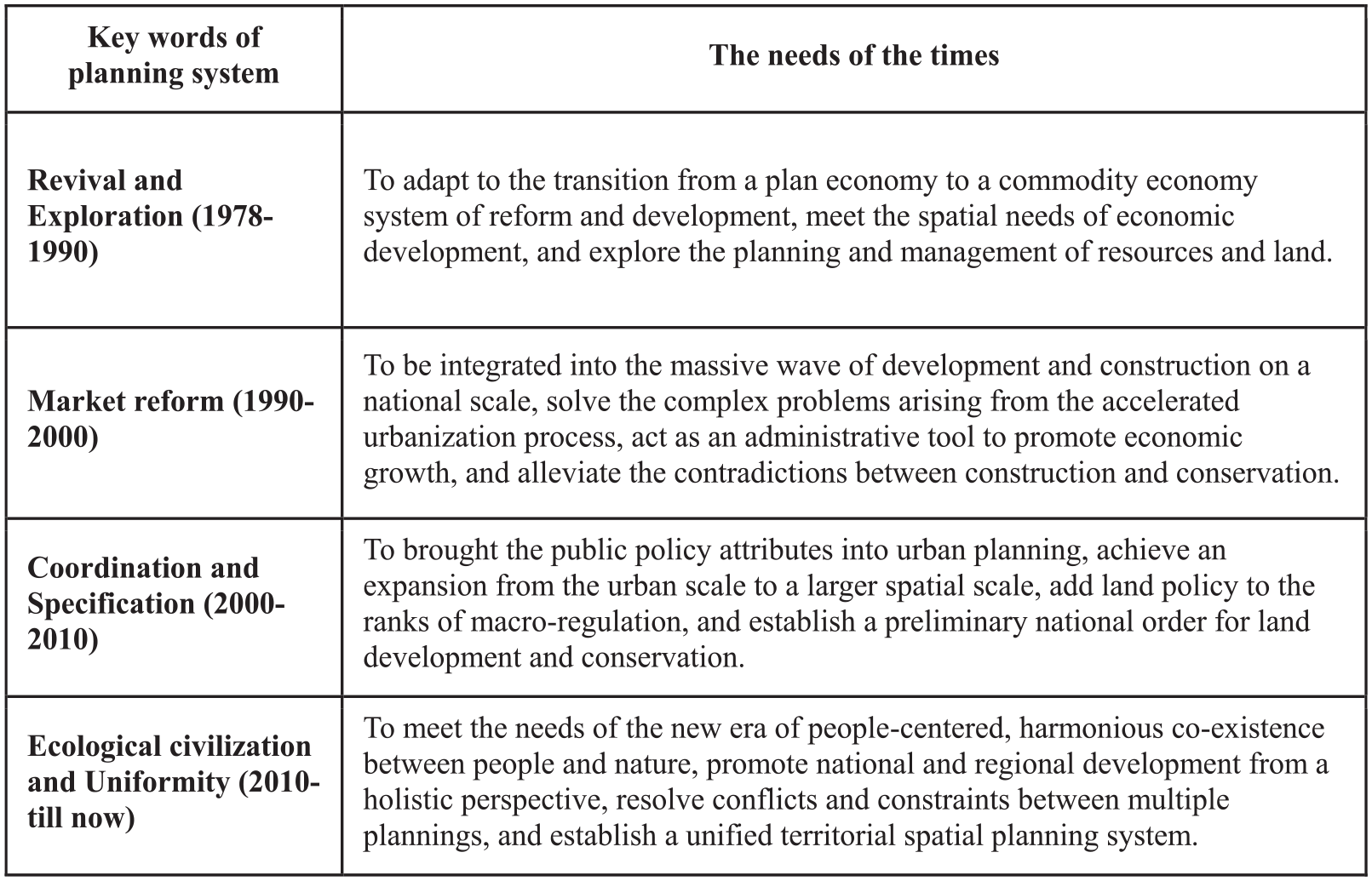
Table of planning system keywords with corresponding needs of the times in different periods.
Footnotes
Declaration of conflicting interests
The author(s) declared no potential conflicts of interest with respect to the research, authorship, and/or publication of this article.
Funding
The author(s) received no financial support for the research, authorship, and/or publication of this article.