
Abstract
Tropical peatlands store globally significant quantities of carbon and are ecologically and culturally important, but little is known about their vulnerability to oil and gas exploration and extraction. Here, we analyse the exposure of tropical peatlands to the activities of the petroleum industry and review what is known about the sensitivity of peatlands to these activities. We find that 8.3% (107,000 km2) of the total area of tropical peatlands overlaps with a 30-km buffer area around oil and gas infrastructure. Major areas of overlap include the Sumatra Basin (Indonesia), the Niger Delta (Nigeria) and the Putumayo-Oriente-Marañón Basin (Peru/Ecuador/Colombia). Documented environmental impacts include deforestation and habitat loss associated with the exploration and development of oil fields, and contamination from spills of oil and produced water (well brine). Peatlands, and the ecosystem services they provide, are sensitive to these impacts due to unique aspects of their ecology and hydrology, the easy spread of contamination by flowing water, the long-term storage of contaminants in peat, and the slow degradation of oil under anoxic, waterlogged conditions. Given the potential negative consequences for human health, resource security, biodiversity, and carbon storage, we propose a research agenda to provide an improved evidence base to support effective governance.
Introduction
Our understanding of the tropical carbon cycle has improved dramatically in the last 15 years, not least through the scientific recognition that substantial peatland complexes exist in Amazonia (storing > 5 Gt C [billion tonnes of carbon]; Freitas et al. 2006; Lähteenoja et al. 2009; Draper et al. 2014; Hastie et al. 2022) and the central Congo Basin (∼30 Gt C; Dargie et al. 2017; Crezee et al. 2022). Along with peatlands in Southeast Asia and elsewhere across the tropics, tropical peat deposits are now thought to store 152–288 Gt C, some ∼25% of the tropical terrestrial carbon pool (Ribeiro et al. 2020). However, anthropogenic pressures such as drainage and land cover change have led to globally significant losses of peat carbon to the atmosphere, especially in Southeast Asia (e.g. Miettinen et al. 2017a). Efforts are being made to reduce anthropogenic CO2 emissions by protecting the carbon stored in these peatlands (e.g. Crump 2017; Murdiyarso, Lilleskov, and Kolka 2019), but continuing demand for fossil fuels is supporting oil and gas production and exploration in many of the same regions (e.g. Finer et al. 2008, 2013; Roucoux et al. 2017; Dargie et al. 2018). While international attention often focuses on their carbon storage, tropical peatlands are also important for their biodiversity (e.g. Draper et al. 2018; Honorio Coronado et al. 2021) and for the resources they provide to local communities (e.g. Schulz et al. 2019a).
Research on the environmental and social impacts of the oil and gas industry in tropical latitudes in general has documented many cases of contamination of flora, fauna, soils and water, alongside health problems and adverse effects on local livelihoods (e.g. Bebbington and Bury 2013; Orta-Martínez, Pellegrini, and Arsel 2018a). However, there has been little research on the impacts of the oil and gas industry specifically on tropical peatlands. In Southeast Asia, where the widespread occurrence of peat has been recognized in the scientific literature for over a century (Wichmann 1910), much has been written on agriculturally driven land use change and drainage, which have led to huge carbon losses from peatlands through oxidation and burning (Page et al. 2002; Miettinen, Shi, and Liew 2012a; Miettinen et al. 2017a, 2017b). There has been little research on the impacts of the oil and gas industry on peatlands here, despite the long history of the industry in the region (since the 1870s: Lindblad 1989) and the potential for further expansion in, for example, Indonesia (Satyana 2017) and Papua New Guinea (Kawagle 2007). The newly recognized peatlands in the Amazon and Congo basins, densely forested and located in sparsely populated regions with few roads, are difficult for researchers to access; scientific understanding of their distribution and ecology is still at an early stage. Hydrocarbon exploration is beginning in the central Congo Basin (Dargie et al. 2018) with the first discovery of oil reported from a well on the margins of the peatlands in the Republic of Congo in 2019 (Le Monde 2019) and blocks overlapping peatlands in the Democratic Republic of Congo about to go to tender at the time of writing (Cabinet du Premier Ministre de la République Démocratique du Congo 2022; Climate Home News 2022). In contrast, the Amazon basin has been one of the main oil exploration frontiers in South America for many decades, with a renewed boom around 2010 (Finer, Jenkins, and Powers 2013). Modelling based on satellite data predicts that extensive additional areas of peatland may exist in Africa and Amazonia, yet to be confirmed by fieldwork (Gumbricht et al. 2017a). Therefore, there is clear potential for the oil and gas industry to operate in and around tropical peatlands for decades to come, raising environmental concerns (e.g. Global Witness 2022; Rainforest Foundation 2022), yet the extent to which the peatlands are likely to be affected is not well known.
Here we set out a new topic within environmental geography by making a first assessment of the vulnerability of tropical peatlands to oil and gas exploration and extraction. Following, for example, Adger (2006) and Dawson et al. (2011), vulnerability can be understood as consisting of three components: exposure, sensitivity, and adaptive capacity. Applied to our topic, ‘exposure’ means the extent in space and time to which the oil and gas industry has an effect on peatlands, while ‘sensitivity’ refers to the degree to which ecosystem processes (e.g. carbon storage, peat decomposition) or properties (e.g. biodiversity, water table depth) are affected by activities such as oil spills or seismic exploration. Using this framework, we address the following questions:
The third component of vulnerability, ‘adaptive capacity’, is typically understood as referring to the ability of a system to change in such a way as to make it less susceptible to environmental hazards (Adger 2006). We return to this subject in the discussion, where we focus on the role of research and data-gathering in improving the adaptive capacity of tropical peatland socio-ecological systems via policy and governance.
Definitions and data sources
The term ‘peatlands’ refers to wetland ecosystems that develop soils consisting mainly of partially-decomposed organic matter to a depth of at least 30 cm (precise definitions of ‘peat’ vary: Lawson et al. 2015). Tropical peatland ecosystems – those occurring between 23.45° north and south of the Equator – are (in lowland regions) typically dominated by hardwood trees and/or palms and may be referred to as peat-forming forested swamps or peat swamp forests (Figure 1).
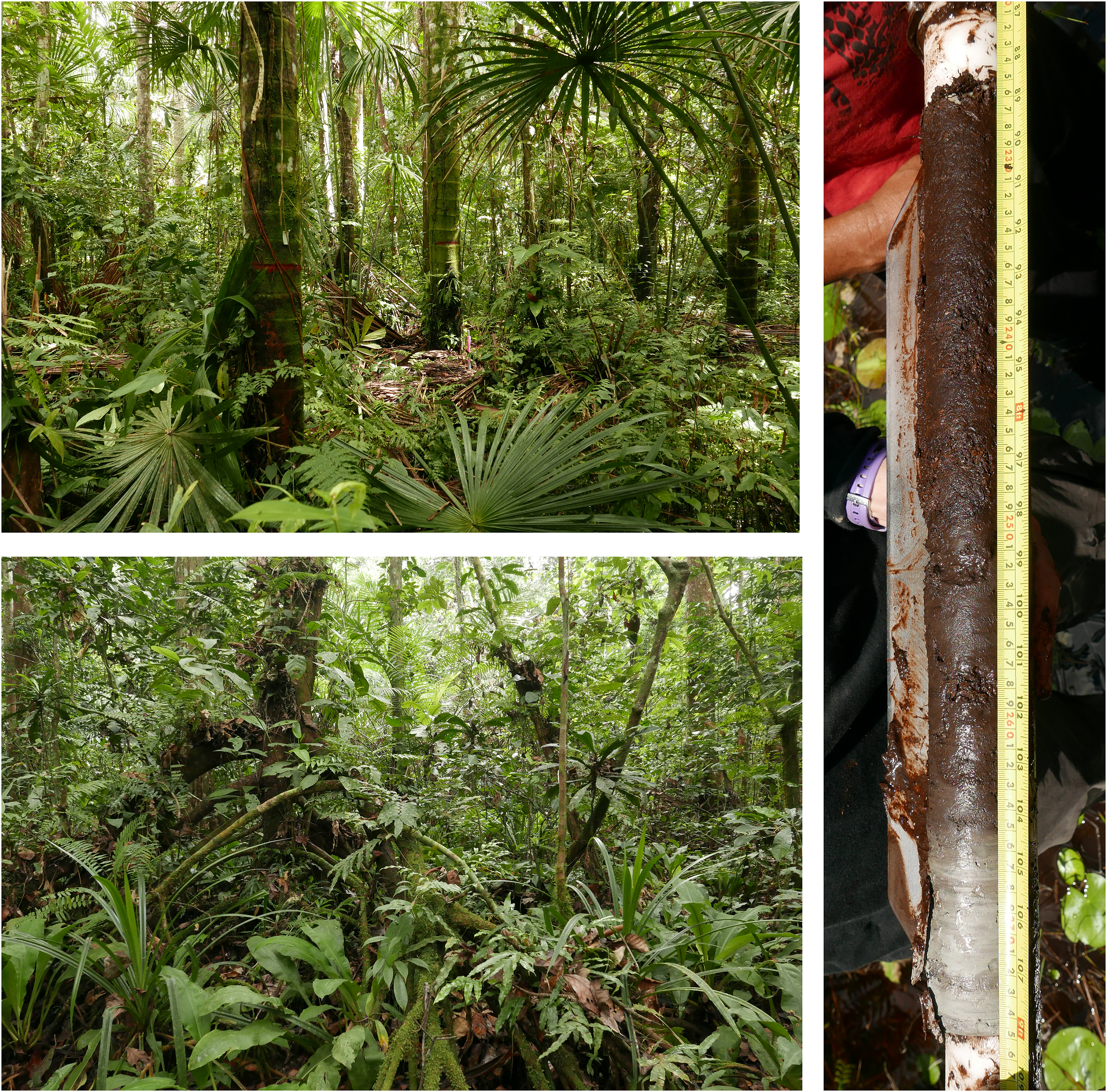
Top left: Peat-forming aguajal (Mauritia flexuosa-dominated palm swamp), Veinte de Enero, Peru. Bottom left: Peat-forming hardwood swamp, Ekolongouma, Republic of Congo. Right: The basal 0.5 m of a ∼2.6 m peat sequence from an herbaceous peatland at Veinte de Enero, Peru. The core shows the contact with underlying clayey silt; the top of the core section is towards the top of the image. Source: The authors.
To map the historical development of hydrocarbon infrastructure across the whole of the tropics, we used the most up-to-date, open, globally-consistent spatial dataset on oil and gas wells currently available, PETRODATA v1.2, which was compiled using data from the late 1920s to 2003 (Lujala, Rød, and Thieme 2007; cf. Hunziker and Cederman 2017). A 30-km buffer inherent in the PETRODATA dataset reflects uncertainty over the precise locations of individual wells and related infrastructure in a given oil field. To estimate the geographical overlap of this infrastructure with peatlands, we overlaid the PETRODATA dataset with layers for (1) sedimentary basins (CGG Robertson 2019) and (2) tropical peatlands (Gumbricht et al. 2017a, 2017b). The latter dataset predicts peatland extent across the tropics using a consistent methodology based on topographic data and modelling of soil moisture from optical satellite imagery; the largest areas of peatland that it predicts for tropical latitudes correspond reasonably well with more detailed, ground-referenced mapping where that exists (e.g. Draper et al. 2014; Dargie et al. 2017; Anda et al. 2021; Hastie et al. 2022; Crezee et al. 2022).
To further assess the historical exposure of peatlands to oil pollution, we mapped the frequency and number of oil spills in two regions where good recent data are available: the Niger Delta in Nigeria and the Pastaza-Marañón Basin in Peru. We used data on the frequency and number of recorded oil spills from the National Oil Spill Detection and Response Agency (data from 2006 to 2021) for Nigeria (NOSDRA 2021), and from the Supervisory Agency for Investment in Energy and Mining (1977–2010) and the Environmental Assessment and Enforcement Agency (2011–2019) for Peru (InfraAmazonia 2021). We mapped pipeline locations using data from Auch (2014) for the Niger Delta and InfraAmazonia (2021) for Peru.
Exposure
Our analysis of geospatial data indicates that peatlands in the tropics have historically been more than twice as densely occupied by oil and gas infrastructure as non-peatland areas (Figure 2 and Table 1). Overall, 8.3% (∼106,700 km2) of the area of tropical peatlands overlaps with the 30 km buffer around oil and gas wells in the PETRODATA dataset, compared with only 3.2% of the non-peatland tropical land area. This analysis indicates that peatlands are proportionally more exposed to oil and gas impacts than non-peatland areas. The PETRODATA dataset is out of date in some areas and does not account for pipelines or exploration activities such as cutting of seismic lines. Where more detailed and up-to-date information exists (i.e. in the Niger Delta and Pastaza-Marañón Basin), it seems clear that the spatial footprint of the oil and gas industry is greater than these figures suggest, including in tropical peatlands (Figure 3).
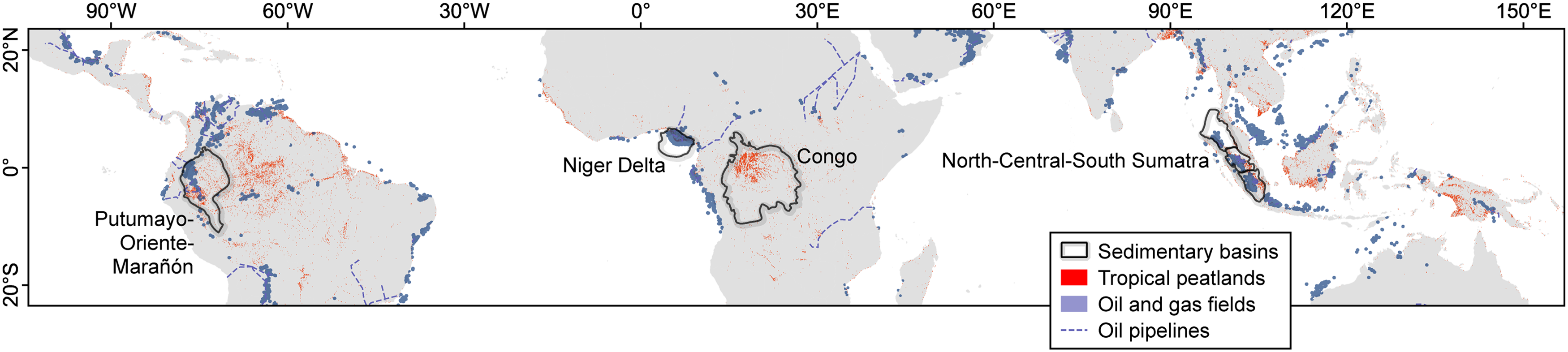
The spatial relationship between oil and gas infrastructure and peatlands across the tropics. Selected locations discussed in the text are indicated. Sources of data are given in the text.
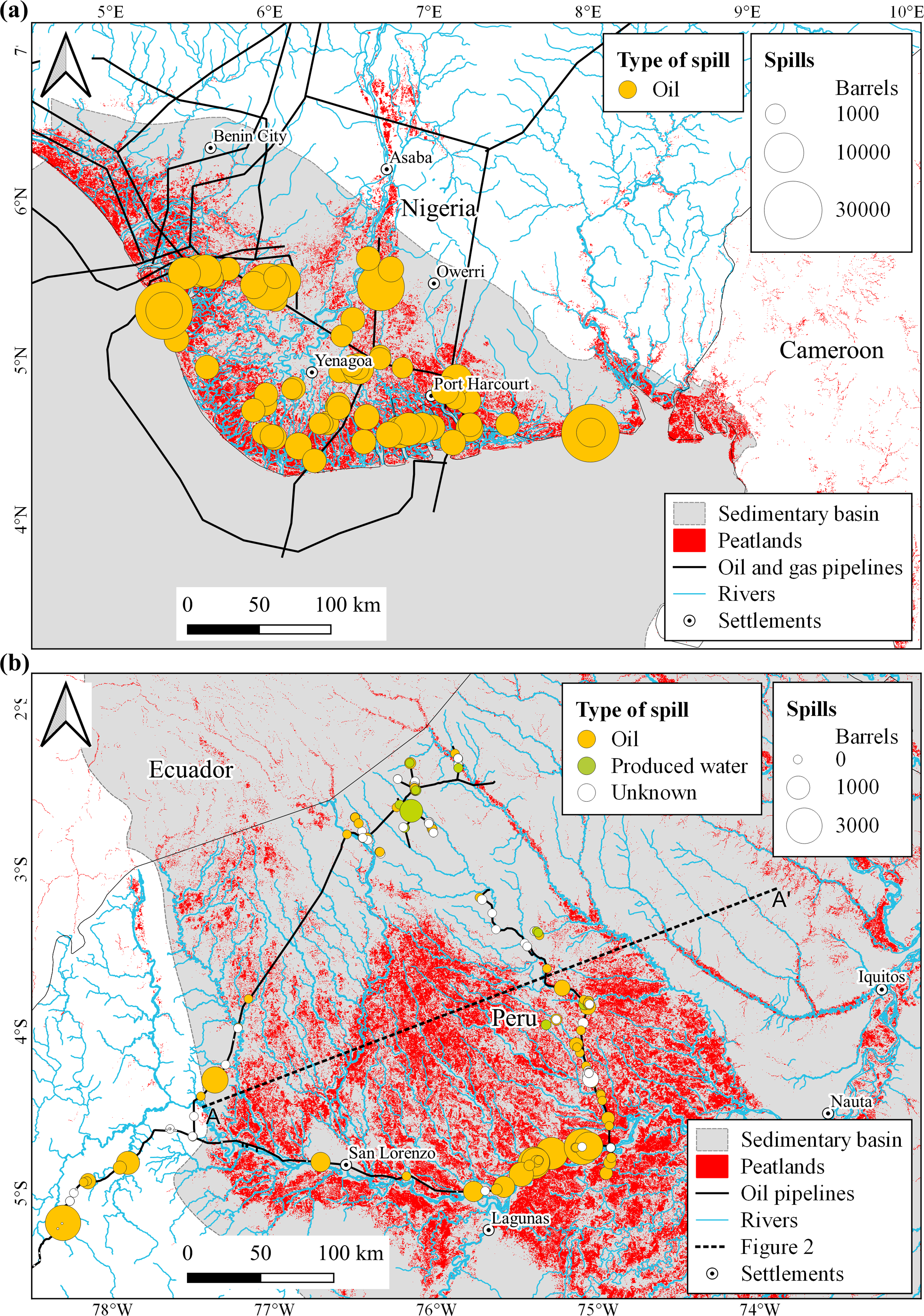
Spatial distribution of oil spills, pipelines and estimated peatland extent in (a) the Niger Delta, Nigeria, western Africa and (b) the Pastaza-Marañon Basin, Peru, north-western Amazonia. Sources of data are given in the text.
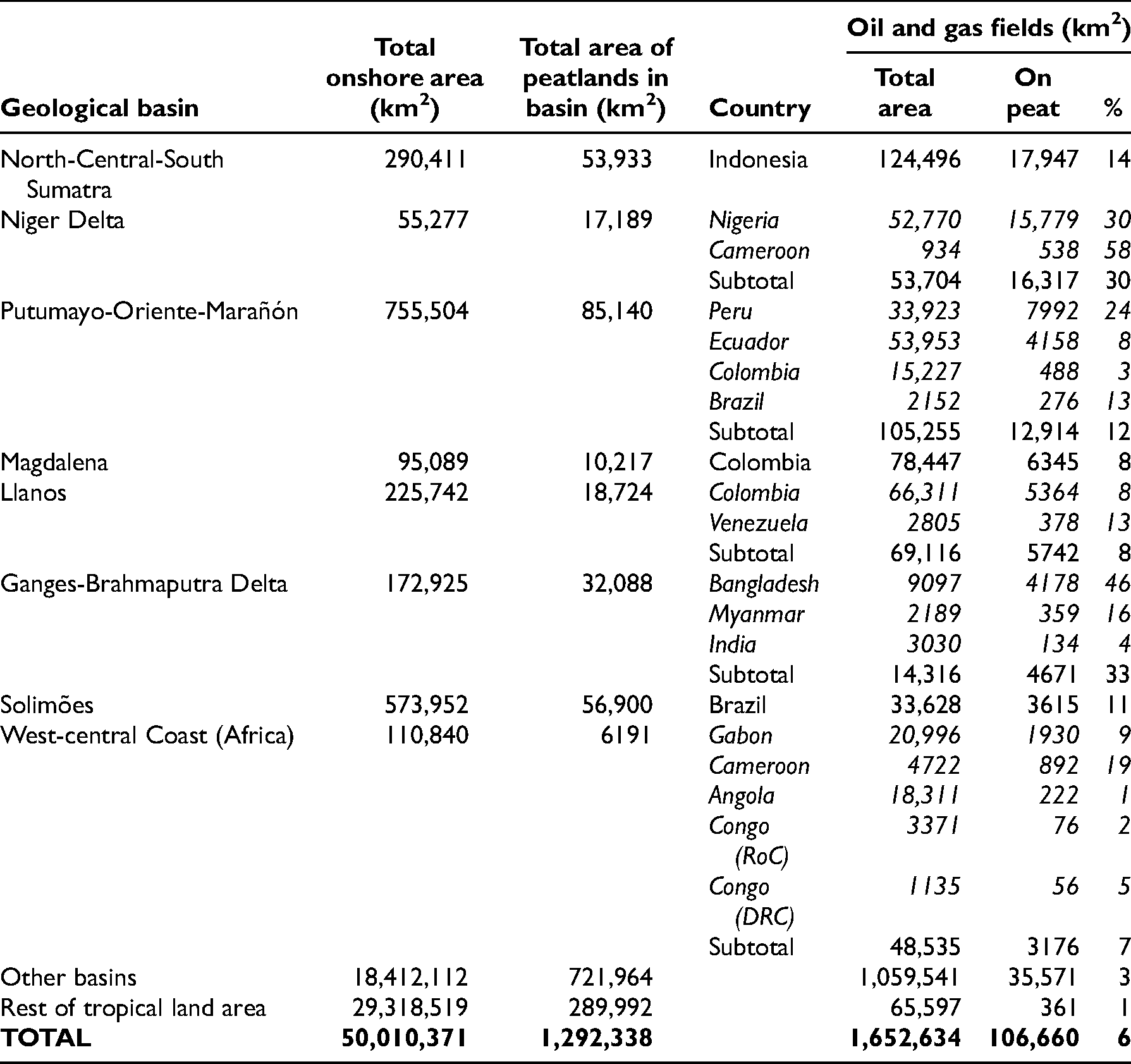
The co-location of geological basins, peat, and oil wells on land in the tropics. Calculations based on datasets from CGG Robertson (2019), Lujala, Rød, and Thieme (2007) and Gumbricht et al. (2017a, 2017b); the tropical region is defined as lying between 23.45° north and south of the Equator. Basin names follow Lujala, Rød, and Thieme (2007). The eight basins (or geographically adjacent groups of basins) with the greatest estimated areal intersection of peat and oil wells are presented in descending order, along with totals for the whole of the tropical landmass.
A genetic link between peat, coal, oil and natural gas may explain why oil and gas activities are disproportionately common on present-day tropical peatlands: these materials all tend to accumulate in subsiding geological basins. Peat formation in the tropics is common in basins where topographic gradients are low, drainage is slow, and the soil is permanently waterlogged, inhibiting plant litter decomposition. Peat forming in such settings today is frequently less than 10,000 years old at its base and rarely more than 30,000 years old (e.g. Dommain et al. 2014; Dargie et al. 2017; Anda et al. 2021). Oil and gas source rocks, which are typically much older, usually also originated in topographic basins as marine or lacustrine sediments which were then deeply buried by ensuing sedimentation (Bjørlykke 2015). More rarely, deeply buried peats – which over time are transformed into coals – can themselves become a source rock for oil and gas (e.g. in Sumatra: Doust and Noble 2008). Although the processes of oil and gas formation and migration typically take tens to hundreds of millions of years, the sedimentary basins in which they occur can have equally long lifespans and are often still subsiding today. This explains why oil and gas reserves so frequently occur below modern peatland complexes (Figure 4). On the other hand, exploitable hydrocarbon deposits will not necessarily underlie a modern-day peatland complex, because modern geological basins may never have passed through a substantial marine or lacustrine phase, or they may lack the history of faulting and folding that forms hydrocarbon traps. Therefore, despite their frequent co-location, the presence of peat does not in itself necessarily imply the presence of substantial oil and gas reserves.
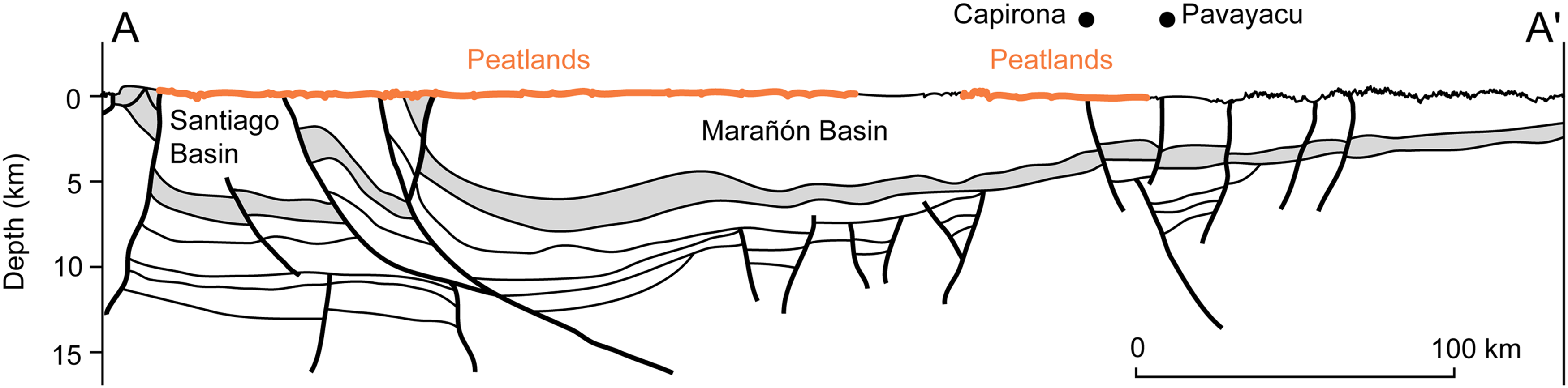
Schematic cross-section of the structural geology of the Pastaza-Marañón Basin. For the location of the section, see Figure 3. Subsurface geometry is simplified from Higley (2001); principal peatland locations (shown schematically as thick orange lines) follow Draper et al. (2014); surface topography is based on Shuttle Radar Topography Mission data, with 10x exaggeration for clarity. In this region oil and gas deposits are mostly located in reservoir rocks of Cretaceous age (grey shading), in structural traps such as those formed by faults (thick lines) at the Capirona and Pavayacu wells. Actively forming peat is found on the surface, up to ∼8 m thick. Older, buried peats also occur below the surface (not shown).
Based on our geospatial analysis, we identified three key regions where such co-location has occurred: the Sumatra Basin in Southeast Asia, the Niger Delta in West Africa and the Putumayo-Oriente-Marañón Basin in north-west Amazonia. These three areas together comprise 44% (47,200 km2) of the intersection between tropical peatlands and the PETRODATA dataset and represent tropical peatlands on three continents with contrasting biogeographical, geomorphological, historical and political contexts. The exposure of peatlands to oil and gas activities in these regions is explored in more detail below.
Indonesia: The Sumatra Basins
Present-day peatlands in Sumatra started to develop during the Holocene, up to 7700 years ago, largely on waterlogged coastal plains (Supardi, Subekty, and Neuzil 1993; Dommain et al. 2014). Over time, these swamps developed into extensive peat domes (Rieley and Page 2016). Several oil production areas occur in or around these peatlands in a series of foreland basins extending along the eastern part of Sumatra in Indonesia where the Australian and Sunda tectonic plates meet (McCaffrey 2009). These basins are Cenozoic in age (i.e. younger than 66 Mya) and are filled by a variety of deep-marine, lacustrine, estuarine and fluvio-deltaic sediments, some of which are rich in organic material (Doust and Noble 2008). Cenozoic movements along regional faults related to the Great Sumatran Fault which runs along the island have created structural ‘traps’ where oil and gas accumulate (Darman and Sidi 2000).
Following a period of exploration, commercial oil production in Sumatra (by the Royal Dutch Oil Company) started as early as 1890 and expanded steadily across the island, initially under the direct control of the Dutch colonial government until Indonesia became independent in 1945 (Lindblad 1989), and subsequently mostly by private companies in partnership with the state oil company PERTAMINA (Nordås, Vatne, and Heum 2003). This investment, coupled with strong political institutions (Ascher 2012), made Indonesia a major oil exporting nation and drove much economic and infrastructure development (Colombijn 2002). For example, roads built for the oil and gas industry were frequently constructed on causeways to avoid flooding where they cross peatlands (Barry, Brady, and Younger 1992) and extensive pipelines have been constructed. In some cases, considerable legislative and managerial effort has gone into limiting the direct environmental impacts of exploration and production (e.g. the Zamrud oil field in central Sumatra, developed in 1975–1982 in a designated conservation area: Yunan and Haryanto 2002; Setiani 2004). In recent decades domestic demand for oil in Indonesia has steadily risen but oil production, including in Sumatra, has fallen as yields from mature oil fields decline (Hurri et al. 2019).
Data from monitoring of marine oil spills are available for Sumatra (Gautama 2017), and frequent news reports and academic articles make it clear that marine oil pollution is an issue of concern, but we are unaware of a comparable publicly accessible monitoring system for inland oil spills. There are occasional reports of spills due to vandalism or earthquakes/tsunamis (Watts Hosmer, Stanton, and Beane 1997; Tobita et al. 2006). The potential threats to peatlands from the oil and gas industry in this region have been little explored in the academic literature, which has tended to focus on the consequences of rapid land use change for plantation forestry and agriculture (Miettinen et al. 2012b).
Nigeria: The Niger Delta
The Niger Delta is the most important petroleum system in western Africa. The Delta occupies a depression at a tectonic rift ‘triple junction’, where three tectonic plates split apart during the opening of the southern Atlantic Ocean (Burke, Dessauvagie, and Whiteman 1971). Since the late Jurassic or early Cretaceous (i.e. over the last ∼150 My) sediments have accumulated in this depression to a depth of more than 10 km, including basal marine shales which are the likely source rocks. Oil and gas have subsequently migrated from here into overlying reservoir rocks including deltaic sandstones. The Delta has steadily built out towards the sea, forming a 300,000 km2 structure rich in oil, most of which is readily accessible by onshore drilling (Tuttle, Charpentier, and Brownfield 1999). Oil exploration in the Niger Delta started in 1908 and the first onshore commercial oil discoveries were made in 1956 (Ite et al. 2013). Exploration and production increased rapidly from the 1970s onwards, turning Nigeria into one of the largest oil producers in the world.
Peat is known to occur widely in the Niger Delta at the present day but, as in many parts of the tropics, its full extent is still unclear. There are numerous first-hand reports of peat and organic-rich floodplain soils in the academic literature (e.g. Akpokodje 1989; Osuji and Ezebuiro 2006; Jamabo and Chinda 2010; Osuji, Erondu, and Ogali 2010; Dike and Agunwamba 2012), and modelling using remotely sensed data (Gumbricht et al. 2017a) predicts that peat is widespread across the Delta. The gently sloping land surface is prone to waterlogging, and mangrove and freshwater swamp forests cover about half of the Delta’s terrestrial surface (NDES 1997). The presence of low-rank coals buried in the Delta sediments (Tuttle, Charpentier, and Brownfield 1999; Ogala et al. 2020) suggests that peat formation occurred intermittently during the Cenozoic.
The contentious role of the oil industry in Nigeria has been widely discussed (e.g. Obi 2010; Watts 2004; Tantua, Devine, and Maconachie 2018). Numerous oil production wells are located within the wetland ecosystems of the Niger Delta, and channels have been dredged to float oil rigs and lay pipelines (Ohimain 2004; UNEP 2011: 156). The Niger Delta has become notorious for the extent and degree of environmental contamination by crude oil spills (e.g. UNEP 2011; Langeveld and Delaney 2014; Duke 2016). A total of 7659 confirmed oil spills, amounting to 575,740 barrels of oil, were officially recorded onshore in the Niger Delta between 2006 and 2021 alone, affecting both terrestrial and wetland ecosystems (NOSDRA 2021; a standard barrel of oil equals 159 L); about 60% of the volume spilled resulted from 100 major events (Figure 3(a)). Langeveld and Delaney (2014) estimated that 13 million barrels of oil may have been spilled since production began in the region. Many authors have discussed oil spills and their ecological and social consequences in the Niger Delta (e.g. Kadafa 2012; Okafor-Yarwood 2018; Elekwachi et al. 2009).
Peru/Ecuador/Colombia: The Putumayo-Oriente-Marañón Basin
The Putumayo-Oriente-Marañón Province is the main petroleum system in north-western Amazonia. It extends from Peru northwards into Ecuador and Colombia, occupying an ancient marine basin that contains sedimentary source rocks that may be as old as Devonian (∼420–360 Mya). The oil and gas formed in these source rocks have migrated into younger (usually Cretaceous) sandstones, which have been deformed and faulted by more recent (late Cenozoic) tectonic movements related to the uplift of the Andes, forming structural traps in which oil and gas accumulate (Higley 2001; Figure 4). Oil exploration started in the Putumayo-Oriente-Marañón Basin in the 1920s. The first commercially viable oil fields were discovered in 1963 in Colombia (Higley 2001), stimulating widespread seismic exploration and infrastructure development throughout the basin during the later 1960s and the 1970s; a renewed phase of exploration began in the 2000s (Finer and Orta-Martínez 2010).
The southern part of this ancient tectonic basin, the Pastaza-Marañón Basin, saw renewed subsidence during the Miocene (Roddaz et al. 2010) and gradually filled with sediments brought by rivers from the Andes. River-borne sands and silts continue to accumulate today, creating a gently sloping surface which is prone to waterlogging. This nearly flat topography, coupled with high rainfall, make the Pastaza-Marañón Basin the setting for the largest peatland complex presently known in Amazonia. More than 3 Gt C is stored in approximately 35,000 km2 of peatland (Draper et al. 2014; Hastie et al. 2022). Present-day peat deposits started to accumulate up to 8900 years ago (Lähteenoja et al. 2012), commonly in abandoned river channels. Over time these typically develop into minerotrophic forested swamps dominated by palms and/or ombrotrophic, thin-stemmed pole forest swamps (Roucoux et al. 2013; Kelly et al. 2017; Honorio Coronado et al. 2021). Less well-documented peatlands are known to occur in other parts of the Putumayo-Oriente-Marañón basin (Hastie in prep.).
The most important oil production concession overlapping with the Pastaza-Marañón peatlands is designated ‘Lot 8’. Most of its production wells are sited on tierra firme (dry land) soils, but 200 km of the Oleoducto Nor Peruano pipeline crosses peatlands, specifically along the first section (‘Tramo I’) which links the Amazonian oil wells at San José de Saramuro and Saramiriza to the second section (‘Tramo II’) which leads towards the coast. During the construction of the first section of the pipeline in the late 1970s, a flotation channel was dredged and maintained to the present day as a containment barrier for oil spills (Petroperú 2021). Nonetheless, the pipeline has been a recurrent source of contamination. Peru reported 192 oil spills in the Pastaza-Marañón Basin between 2011 and 2019 totalling ∼17,760 barrels (e.g. Fraser and Tarabochia 2016; Okamoto and Leifsen 2012; Parra Mujica, Manrique López, and Martínez Zavala 2019), including at least six major events (>1000 barrels) on and adjacent to peatlands along the Oleoducto Nor Peruano (InfraAmazonia 2021; Figure 4(b)). Until about a decade ago, ‘produced water’ – the brine that often accompanies oil, a waste by-product – was another significant source of pollution, to the point of detectably altering sodium and chloride concentrations in the entire downstream Amazon River (Moquet et al. 2014). As discussed below, there is a small but growing academic literature on this and other environmental effects of the oil industry in western Amazonia, supplementing the better-established literature on social and health issues.
Sensitivity
In the preceding section, we have shown that tropical peatlands have been substantially exposed to oil and gas industry activities over a wide area and for many decades. In this section, we look in more detail at the impacts of these activities and review what is known about the sensitivity of tropical peatland vegetation, fauna, soils, sediments, hydrology, and ecosystem function to them. This sensitivity is only patchily understood: few studies focus on disturbance or pollution by the oil and gas industry specifically in inland, freshwater peat swamp forests. Our review identified five categories of activity that are especially relevant to tropical peatlands: deforestation and habitat degradation; hydrological disturbance; contamination by oil spills; contamination by produced water; and immigration and expansion of the economic frontier. We introduce each in turn and then discuss the sensitivity of tropical peatlands to these activities.
Deforestation and habitat degradation
One of the special features of peatlands is that they are difficult to access. Swamp forests often have dense undergrowth, the peat is soft and treacherous to walk on, the peatland may be deeply flooded, and even in the dry season permanent ponds and lakes impede movement. That does not mean that tropical peatlands are pristine wildernesses: many peatlands (e.g. in Indonesia) have been drained, deforested, and converted to agriculture, and even hydrologically intact peatlands close to rural communities are frequently exploited for resources such as fruit, game, or building materials (Schulz et al. 2019a). But hard-to-access, largely intact peatland swamp forests represent some of the last refuges for species such as (in Peru) anaconda and black caiman, (in Indonesia) orang-utan, and (in the Congo Basin) forest elephant and lowland gorilla (Cattau, Husson, and Cheyne 2015; Roucoux et al. 2017; Dargie et al. 2018). Loss of forest cover is therefore a significant concern from the point of view of biodiversity conservation. It also has a critical effect on the carbon balance of peatlands. In a naturally functioning peatland, carbon is drawn from the atmosphere by plants during photosynthesis, and their leaves, stems and roots enter the peat as litter. This constant input of carbon is partly offset by the slow (natural) decay of the peat itself (e.g. Frolking et al. 2010; Kurnianto et al. 2015). So long as litter inputs exceed the decay rate of the peat column, the peatland functions as a net carbon sink, removing carbon from the atmosphere. If litter inputs drop – for example, due to deforestation – then, everything else being equal, the peatland’s carbon accumulation rate will be negatively affected, exacerbating anthropogenic climate change. Deforestation may also accelerate the decomposition of the surface peats due to increased soil temperature, reduced soil moisture, and/or increased nutrient supply to microbial communities (Gandois et al. 2013). So, for these two reasons, biodiversity and carbon conservation, tropical peatland ecosystems are sensitive to loss of forest cover.
Oil and gas activities directly cause deforestation and habitat degradation in constructing seismic survey lines, access roads, airports, drill pads, exploratory drilling, pipeline routes, and worker accommodation (Finer et al. 2008). Seismic surveys serve to illustrate the types of activities and effects on the environment that are involved. Seismic surveys typically entail a team clearing vegetation in numerous transects across the landscape, periodically drilling a short borehole and detonating an explosive charge at its base, then recording the sound reflections from the rocks beneath, which gives insights into the underlying stratigraphy. Records of seismic lines indicate that hundreds of thousands of kilometres of trails have been cut in tropical forests to provide access for this exploratory work: 78,500 km in the north and south Sumatra basins (Wicaksono, Setyoko, and Panggabean 2009; Lemigas 2017); 462,000 km in western Amazonia (Codato et al. 2019); and already 3600 km in the Congo basin (Delvaux and Fernandez-Alonso 2015). Many peatlands have been densely traversed by seismic surveys, with parallel lines often only a few kilometres apart. Yusta et al. (2015: 103) estimate that in just one part of the Pastaza-Marañón Basin, the Pacaya Samiria National Reserve, some 800 ha of forest cover was lost, and a further 35,000 ha subjected to so-called ‘edge effects’: disturbance that may have a measurable ecological effect hundreds of metres away from the transect itself. In rainforest in Gabon, elephants and apes have been shown to avoid the noise pollution associated with seismic surveys, representing temporary habitat exclusion (Rabanal et al. 2010) – another form of ‘sensitivity’. The current best practice aims to mitigate the worst effects of seismic surveys by cutting narrow lines, avoiding felling large trees, and inserting and supplying teams by helicopter rather than by building access trails, measures which reduce but do not eliminate the impacts (e.g. Thomsen et al. 2001; Talisman 2010; CEPSA 2012; Finer, Jenkins, and Powers 2013).
Hydrological disturbance
In well-drained soils, plant litter is rapidly decomposed by bacteria, fungi, and invertebrates under aerobic conditions, that is, with a ready supply of oxygen to fuel respiration. In waterlogged peatland soils oxygen diffuses very slowly through the stagnant water, so ordinary aerobic respiration becomes impossible, the rate of decomposition of organic matter is substantially reduced, and the plant litter accumulates as peat. Any damage to a peatland’s hydrological integrity, particularly any change that accelerates drainage or otherwise lowers the water table, risks introducing oxygen into the peat, accelerating mineralization, and turning the peatland into a net source of carbon to the atmosphere (IPCC 2014; Page and Baird 2016). Tropical peatlands may be especially sensitive to hydrological disturbance (relative to temperate/boreal peatlands) because of high rates of evapotranspiration in tropical climates (Garcin et al. in review) and because their typically coarse, woody peat has a high hydraulic conductivity (Kelly et al. 2013), which means that water flows readily out of the peatland into drainage ditches and canals.
Hundreds of kilometres of pipelines and roads have been built across peatlands in the tropics (Figures 3 and 5), often maintained for decades afterwards (e.g. in Sumatra: Barry, Brady, and Younger 1992; Colombijn 2002). Peatland ecohydrological processes are sensitive to road-building in numerous ways (reviewed by Williams-Mounsey et al. 2021), including by reducing the lateral flow of groundwater (e.g. Salvador, Monerris, and Rochefort 2014; Chimner et al. 2017; Plach et al. 2017). Hydrological damage does not always involve the peat becoming drier: for example, in Canada, seismic lines and roads have been shown to compact the peat and thereby increase surface waterlogging, which led to increased emissions of the powerful greenhouse gas methane to the atmosphere (Strack et al. 2019; Saraswati and Strack 2019). There has been very little research on the impacts of roads specifically on tropical peatlands (Williams-Mounsey et al. 2021). An alternative way to move machinery and materials through a peat swamp is to dredge a canal, then float the materials along the canal on barges, as noted above in Nigeria (Urteaga Crovetto 2019; Ohimain 2004) and Peru (Petroperú 2021). The impact on peatland ecohydrology of canals built by the oil industry is unclear, but there is a sizeable literature on the negative consequences of carbon storage of canals built for drainage and/or timber transport in Indonesian peatlands: such canals cause water tables to drop, and oxidative and water-borne losses of carbon from the peat to accelerate (e.g. Ritzema et al. 2014; Gandois et al. 2020).
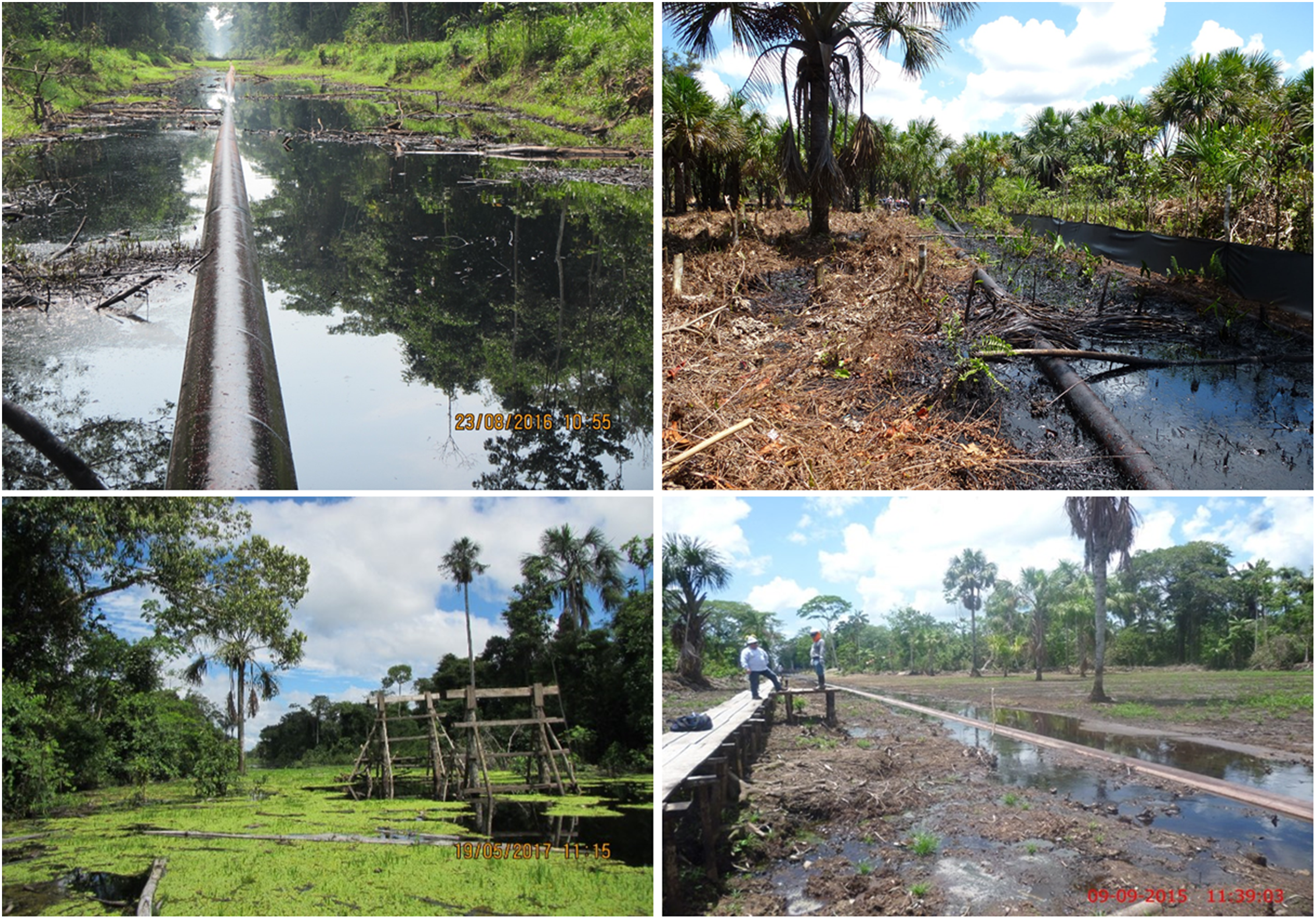
Oil infrastructure and contamination in the wetlands and peatlands of the Pastaza-Marañón Basin in Peru. Top left: dredged channel showing an oil pipeline during low river level. Bottom left: an oil spill at Lot 8 inside the Pacaya Samiria Nature Reserve, 2013. Right: remediation of a November 2014 oil spill near Cuninico showing the clearance of peatland vegetation during periods of (top) high and (bottom) low river levels. Source: All OSINFOR (InfraAmazonia 2021) except bottom left, ACODECOSPAT (2019).
Contamination by oil during extraction and transportation
Oil spills happen around pipelines, transport routes, and transhipment and storage facilities due to accidents, operational failures, poor maintenance, earthquakes, landslides, theft and sabotage. Oil spills are not easily contained in wetland ecosystems, which are typically well hydrologically connected by surface and/or subsurface flows that can reverse on daily (tidal) to seasonal (river flooding) timescales. In both the Pastaza-Marañón Basin and the Niger Delta, oil spills are reported to have spread rapidly and/or widely through streams, rivers, and lakes (Garcia 1995; Yusta et al. 2015; Azevedo-Santos et al. 2016; Onyena and Sam 2020) (Figure 5).
The effects of oil spills on animals in freshwater tropical peatlands have rarely been reported. However, several decades of research on other wetland and peatland systems have demonstrated numerous direct effects of oil spills on animals (e.g. Shales et al. 1989; Steen et al. 1999) ranging from acute toxicity (e.g. death by narcosis; Dupuis and Ucan-Marin 2015), hypothermia from oiling of feathers or fur (Stephenson 1997), anoxia (Couceiro et al. 2006), or habitat destruction (Vinson et al. 2008; Black et al. 2021), to long-term chronic effects on physiology, behaviour and reproduction (e.g. Culbertson et al. 2007, 2008; Kochhann et al. 2013). The toxicity of oil to animals depends on its chemistry, for example, the abundance of low molecular weight aromatic molecules or heavy metals such as mercury (Dupuis and Ucan-Marin 2015), so the sensitivity of the fauna is likely to vary depending on the nature of the oil spilled.
For plants, the effects of acute or chronic pollution can include mortality from direct toxicity and, as stomata are blocked and oil accumulates in the chloroplasts, reduced photosynthetic activity (Pezeshki et al. 2000; Arellano et al. 2017). Sizeable areas of upland forests in Peru (Palacios Vega et al. 2019) and Ecuador (Arellano et al. 2015) are known to have been killed or damaged by oil spills; Palacios Vega et al. (2019) estimated that more than 12,000 ha of forest cover were lost in Peru’s Lot 192, amounting to 2.5% of the total surface area of the concession, between 1986 and 2005; most of this loss was attributed to oil spills. Several studies have focused on the effects of oil spills on Mauritia flexuosa, which dominates many freshwater peat swamps in South America. One study in Venezuela observed the mortality of seedlings and herbaceous plants that were covered in a layer of crude oil but found no effect on the structure or composition of taller plants, including mature specimens of M. flexuosa (Bevilacqua and Gonzalez 1994). Urich et al. (2008), in a similar context, found that photosynthetic rate and other physiological parameters were depressed in M. flexuosa individuals two years after an oil spill, but that a plot contaminated with oil 16 years previously had fully recovered. M. flexuosa has adaptations, such as a thick seed endocarp, which likely give some fortuitous protection against the toxic effects of oil contamination (Hernández-Valencia et al. 2018, 2020). The effects of oil spills on Raphia, another important genus of palms in tropical peatlands, appear to have been seldom investigated, although Daniel-Kalio and Braide (2002) reported numerous dead R. farinifera individuals three months after a crude oil spill in the Niger Delta.
Remediation of areas affected by oil spills is mandatory in our three case study regions but presents particular difficulties in wetlands and peatlands due to poor accessibility and the hydrological, species and functional sensitivities outlined above; effectiveness of remediation is unclear, and the remediation methods themselves may damage the ecosystem (e.g. Getter, Scott, and Michel 1981; Scherrer and Mille 1989; Vandermeulen and Ross 1995; Pezeshki et al. 2000; Fitzpatrick et al. 2015). Digging containment ditches or creating bunds or dams will inevitably disturb the hydrology of the site. Bevilacqua and Gonzalez (1994) showed that burning off spilled oil caused substantial destruction of the standing vegetation in a Mauritia swamp.
A final aspect of the sensitivity of peatlands to oil spills is that the effects may be long-lasting. The high absorption and adsorption capacity of organic matter in peaty soils may lead to longer retention of contaminants where the spillage occurred (Cram et al. 2004), and anoxic and nutrient-poor conditions slow the microbial degradation of oil (Scherrer and Mille 1989; Venosa et al. 2002). In peatlands in Alberta, Canada, oil was still abundant below the surface in peats 25 years after a spill; although various clean-up techniques had been applied at the time of the oil spill, vertical water movements continued to bring unweathered oil to the surface (Wang et al. 1998). This same problem is described by indigenous communities in the Pastaza-Marañón Basin who observe oil on rivers and lakes during high river levels long after the oil spill originally occurred (M. Martín pers. comm. and author observations).
Contamination by produced water
Much of the fluid that emerges from oil wells is not oil, but the water that was trapped with the oil or gas during formation, and/or water and drilling fluids that were injected into the well to enhance petroleum recovery. This ‘produced water’ is rich in hydrocarbons, salts such as sodium chloride, heavy metals (including some that are toxic to humans, such as lead and cadmium), and chemicals used in the hydrocarbon extraction process (Fakhru’l-Razi et al. 2009; Jiménez et al. 2018). The volume of produced water is typically three times greater than that of oil (ibid.).
Produced water has historically been an unwanted burden on oil producers because it is costly to treat. Until recently in Amazonia it was routinely released untreated into rivers, causing widespread environmental pollution throughout much of the Amazon River system (Moquet et al. 2014; Yusta-Garcia et al. 2017; Rosell-Melé et al. 2018). Assessments of the scale of the problem vary: León and Zuñiga (2020) estimated that 408 million barrels of untreated produced water were released into rivers in the Marañon basin in Peru in the historical peak year, 2006; Kimerling (2006) estimated that 76,000 barrels were released daily in Ecuador, equivalent to 28 million barrels per year. A meta-analysis by Yusta-Garcia et al. (2017), based on the 2951 reported water chemistry analyses carried out between 1987 and 2013 by governmental institutions and three oil companies, showed that legal limits for contaminants in river water, including rivers with peatlands on their floodplains, were routinely exceeded in Peru. Only since the late 2000s has it become more common in countries including Peru and Indonesia for produced water to be reinjected into wells or treated to remove contaminants (Helmy and Kaderna 2015; Yusta-Garcia et al. 2017). More effective ways of treating produced water are being developed but, according to Jiménez et al. (2018), regulatory frameworks around the quality of treatment still do not adequately address the full range of harmful substances that may persist in the treated water.
Even though attempts are now made to contain produced water, corrosion of pipework and operational failures still lead to spillages in Peru (León and Zuñiga 2020): at least 1100 barrels of produced water were spilled during 2011–2019 according to official figures (InfraAmazonia 2021). Petroleum products have been detected in sediments downstream of abandoned produced water disposal sites in Peru, suggesting that containment efforts are inadequate (Rosell-Melé et al. 2018). In Nigeria, levels of hydrocarbons and heavy metals near some disposal sites have exceeded regulatory standards because of produced water spills (Isehunwa and Onovae 2011; Ite et al. 2013).
The sensitivity of tropical peatland ecosystems to produced water contamination is not well understood. Disposal of produced water in freshwater streams and rivers is known to kill fish and vegetation due to high concentrations of salt, and heavy metals can also be found in fish tissues at contaminated sites (Garcia 1995). Mammals frequently visit produced water disposal sites as a substitute for natural salt licks (Orta-Martínez, Pellegrini, and Arsel 2018a). Research on produced water has focused instead on the health consequences for people living in and around contaminated wetlands, although this understanding also remains incomplete (e.g. O’Callaghan-Gordo, Orta-Martínez, and Kogevinas 2016; Rosell-Melé et al. 2018; Orta-Martínez, Pellegrini, and Arsel 2018a).
Immigration and the economic frontier
Oil and gas often act as a catalyst for wider economic development in frontier regions. The oil and gas industry has unusual access to financial capital which is invested in expectation of large profits. That capital is available to construct access roads, pipelines, transhipment facilities and docks, and residential facilities for workers. Governments may be highly motivated to support infrastructure development by the oil and gas industry, for example, where they stand to share in oil revenues or where it boosts local incomes (Hilmawan and Clark 2019). There may also be direct investment in local communities by oil companies, for example, by providing employment, financial assistance, health centres or sanitation works (Lu, Valdivia, and Silva 2017). A by-product of this provision of jobs and infrastructure is that it encourages and facilitates immigration.
Road-building emerges as a key factor in enabling immigration (Myers 1993; Laurence 1999, 2013). As an example, Colombijn (2002) describes ‘a wild west frontier’ in Sumatra that developed following the building of a road by the American oil firm Caltex through an area dense with peat swamp forests. The initial impetus for road building was to facilitate the construction of a pipeline, but the road network was maintained and extended to allow easy access to the oil wells. This capital-intensive process removed the barriers to access posed by the swamp forests. As a result, less well-financed logging and wood pulp firms were then able to begin clearing the forests; once the forests were cleared, the land could profitably be converted to plantation agriculture. The road network, with its many side branches to isolated oil wells, also facilitated immigration by ‘opportunistic’ smallholders from outside the region, leading to further land use change.
Remarkably similar histories have accompanied road building by oil firms in the Oriente Basin in Ecuador (Lu, Valdivia, and Silva 2017); there, another documented secondary effect with biodiversity implications was the development of a wholesale market for bushmeat (Suárez et al. 2009). Oil companies have built access roads, airports and harbours in the Niger Delta, which have been linked to deforestation and immigration (e.g. Ayanlade and Drake 2016; Ayanlade and Howard 2017), although it is a widely held view locally that considerably more oil revenue ought to have gone into road-building to support socio-economic development in the Delta (e.g. Naanen 2012). In the Pastaza-Marañón Basin in Peru, by contrast, there has so far been comparatively little road-building specifically in relation to the oil industry (perhaps because transport along the river network there is relatively straightforward), although there are periodic proposals to connect the important oil town of Trompeteros to the national road and/or rail networks (Arima 2016; Roucoux et al. 2017). Nonetheless, population expansion due to immigration, partly in response to employment offered by the oil industry but also tied to a larger political programme of economic colonization of Peruvian Amazonia (Barantes and Glave 2014; Delgado Pugley 2019), has generated new economic frontiers linked to the progressive depletion and degradation of wild resources such as fish, game and palm fruits during the past few decades (Mäki, Kalliola, and Vuorinen 2001; Suárez et al. 2009; Harvey and Knox 2015; Schulz et al. 2019b; van Lent et al. 2019).
Our key point is that peatlands are often among the last places to be developed because building roads (and the necessary foundations, causeways and ditches) through a peat swamp is difficult and expensive. The oil industry, with its access to capital investment and heavy equipment, is often able to open up a peatland complex as a new frontier for other forms of development. The remoteness of these frontiers means that, in the early stages, governance can be weak (e.g. Columbijn 2002; Gallice, Larrea-Gallegos, and Vázquez-Rowe 2019) and environmental degradation may be rapid and extensive. Opportunities for economic development may be welcomed by many stakeholders, although research has cast doubt on the extent to which road-building genuinely benefits local people, who may have little say in the decision-making processes around infrastructure development that can fundamentally transform their way of life (e.g. Harvey and Knox 2015). Road-building itself may have direct effects on the hydrological integrity of peatlands (discussed above), but peatlands are likely to be just as sensitive, and more widely exposed, to ecosystem degradation, deforestation and land-cover changes associated with increased access and increased connectivity to markets, which (via deforestation and drainage) can turn a peatland from an atmospheric carbon sink into a major carbon source. Avoiding road-building is often seen as key to mitigating the environmental costs of extractive industries (Finer et al. 2008; Gallice, Larrea-Gallegos, and Vázquez-Rowe 2019). Cases such as the Pastaza-Marañón Basin in Peru, where road-building has been limited, and implementations of the so-called ‘offshore model’ whereby survey camps and wells are serviced by helicopter (Rosenfeld, Gordon, and Guerin-McManus 2001; Finer et al. 2008; CEPSA 2012), show that it is possible for the oil and gas industry to operate without building extensive road networks, albeit still not without significant environmental costs.
Discussion and conclusions
Our review has shown that although we know that tropical peatlands have been and continue to be widely exposed to several kinds of activity by the oil and gas industry, up-to-date information remains hard to come by for many regions. There is also a substantial lack of data and analysis concerning the sensitivity of peatland socio-ecological systems to these impacts. In this concluding section, we identify six key research gaps around exposure and sensitivity and discuss the potential role of an improved knowledge base in addressing the third component of vulnerability, adaptive capacity.
Six research gaps around exposure and sensitivity
Spatial mapping of peatlands and oil/gas infrastructure
Our knowledge of the spatial distribution of peatlands is still limited in many regions. Existing soil maps have repeatedly proven to be unreliable (e.g. Lähteenoja et al. 2009; Dargie et al. 2017). It is impossible to understand and manage the effects of the oil and gas industry on peatlands if we do not know where those peatlands occur. Peatland mapping is an area of active research (e.g. Hastie et al. 2022; Crezee et al. 2022) and we can expect substantial improvements in both spatial coverage and spatial resolution of peatland maps over the next few years. Equally important is to improve access to data on the distribution of oil and gas infrastructure, building on and updating existing open datasets such as PETRODATA (Hunziker and Cederman 2017). It would also be possible to map at least some aspects of the vulnerability of peatlands to oil and gas exploration and extraction, following precedents in other contexts (e.g. Cai et al. 2015; Margles Weis et al. 2016), by combining predictive maps of peat thickness and carbon storage with spatial data on variables such as remoteness and biodiversity. By making vulnerability more visible, such mapping could lead to more effective environmental impact assessments.
Historical aspects of oil/gas activities on peatlands
As we have shown, the history of oil and gas impacts on tropical peatlands is not well known, but is important for understanding the present situation and the potential for future impacts. Of the many methods that could provide this historical context, we highlight three. Firstly, analysis of historical remote sensing data has a proven track record in providing a large-scale perspective extending back several decades; for example, analysis of historical Landsat imagery documented dry-land forest cover loss in Peru’s Lot 192 between 1986 and 2005 due to the expansion of oil infrastructure and oil spills (Palacios Vega et al. 2019), a study that could be replicated in peatland areas. Secondly, the peat itself, building up slowly through time, preserves a record of environmental change in its chemistry and micropalaeontology (e.g. Lawson et al. 2014) that could be exploited to study anthropogenic impacts, for example, deforestation or contamination by heavy metals, both of which will leave traces in the peat. Finally, research on written and oral histories from local communities and industry employees would provide valuable information on the long-term social, economic, and biodiversity consequences of oil and gas activities in and around peatlands (cf. Schulz et al. 2019a).
Ecosystem responses to oil/gas activities
Our review highlights the need for better data on the sensitivity of tropical peatland ecosystems to oil and gas industry activities, taking into account the fact that tropical peatlands are not a homogenous group, but span a wide range of climates, hydrologies, floras and faunas. For example, outside Southeast Asia almost no published research is available on the hydrological connectivity of tropical peatlands – the way that water moves across these landscapes – and nothing at all on the hydrological consequences of road building, canal construction, deforestation or drainage work associated with the oil industry. Similarly, we know very little about the long-term storage of pollutants in peat, the extent to which those pollutants are incorporated into biogeochemical cycles and food webs, and the extent to which those pollutants migrate horizontally across the landscape and vertically through the peat column in tropical settings (cf. Yusta et al. 2015). The sensitivity to hydrological disturbance and oil contamination of key species such as Mauritia flexuosa and Raphia spp., which dominate peatland vegetation over tens of thousands of square kilometres, needs to be better understood. Field and laboratory studies should go hand-in-hand with research in remote sensing, which is a key tool for upscaling results from site-based studies to achieve a regional overview, and for monitoring changes to land cover and other vegetation properties in remote areas (e.g. Arellano et al. 2015; Adamu, Tansey, and Ogutu 2018). It may also be possible to develop the capacity to monitor changes to the carbon cycle on a landscape scale by enhancing so-called data assimilation models to encompass peatlands (e.g. DALEC: Bloom et al. 2016), work which is in its infancy.
The effectiveness of remediation, restoration, monitoring and regulation
As discussed above, environmental restoration can be difficult in peatlands. Research evaluating the long-term effectiveness of different restoration and remediation methods in tropical peatlands would help to mitigate the effects of future impacts and support effective monitoring and regulation. More broadly, appraisal of the successes and failures of past monitoring and regulatory frameworks would help to design better systems and spread best practices between oil-producing countries. Monitoring and enforcement are hampered by the size and remoteness of many peatlands. Community-based monitoring programmes are increasingly seen as an effective way in which, for example, non-governmental organisations (NGOs) and academics can support and train local communities to monitor oil impacts using technologies such as drones and smartphones, increasing the level of scrutiny (e.g. Orta-Martínez, Pellegrini, and Arsel 2018a; Mena et al. 2020) and addressing power imbalances between rural and indigenous communities and multi-national oil companies (Natcher and Brunet 2020).
Interdisciplinary research to support sustainable development
Our review has focused on the ecological consequences of oil and gas exploration and production in and around tropical peatlands. But peatlands are deeply embedded within socio-ecological systems; their resources often underpin subsistence livelihoods and they can be particularly important to indigenous communities. There is a well-developed literature on the social, political, cultural and ethical implications of the development of oil and gas on indigenous groups in dryland environments in the tropics (e.g. Kimerling 2006; Orta-Martínez and Finer 2010; Lu, Valdivia, and Silva 2017) but relatively little understanding yet of the effects of this kind of development on the often highly specialized ways of life of groups living in and around wetlands. Not least, our understanding of the consequences of oil and produced water contamination is incomplete without considering their effect on human health (Orta-Martínez et al. 2018b; Fernández-Llamazares et al. 2020), or the social and environmental justice implications of the fact that these impacts have frequently fallen disproportionately on indigenous and/or marginalized populations (Orta-Martínez and Finer 2010; Andueza et al. in prep.).
The presence of human populations in and around tropical peatlands represents another impetus, above and beyond carbon and biodiversity conservation, for carefully considered management of peatlands within a framework of sustainable development. These human populations often have deep experience in drawing on and managing peatland resources to support their livelihoods over the long term (Baker et al. 2019). Given that funding for carbon conservation is often synergistic with biodiversity conservation and socio-economic development goals, there is a need for holistic research programmes on the interplay between natural and human ecology in peatlands. This is a substantial challenge because it requires the participation of local communities and close cooperation between researchers working within very different ontological and epistemological frameworks. Examples of integrative research on peatlands at the intersection between the natural and social sciences and the humanities are presently emerging from the Pastaza-Marañón Basin (Roucoux et al. 2017; Schulz et al. 2019a, 2019b; Martín Brañas et al. 2019; Fabiano 2021).
Political ecologies of fossil fuels
At a more theoretical level, political ecologists have long demonstrated that developments in the Earth sciences and associated technologies can result in concomitant changes in the political and economic relations which govern or ‘produce’ socio-natural environments (e.g. Braun 2000). In the case of oil specifically, technological changes leading to either the ‘discovery’ of previously unknown reserves or the rendering extractable of previously inaccessible reserves, can shift political and economic dynamics with great impact at multiple geographical scales (Labban 2008; Bridge 2011). The identification of new frontiers of oil extraction can lead to rapid and dramatic changes in existing socio-ecological relations, extending logics of dispossession and opening new capitalist markets, long before any fossil fuels are even removed from the ground (Watts 2012; Simpson 2019). As claims to territory and property are established or re-entrenched, dynamics between the state, global capital, NGOs, local peoples, and the non-human world are realigned and reconfigured accordingly. Political ecologists could make an important contribution by revealing and critiquing the ways in which technological developments, such as improvements in the spatial coverage and resolution of peatland mapping technologies, are resulting in not only more detailed understandings of tropical peatlands as biogeophysical environments, but also to significant changes in the political and economic dynamics and logics which govern these spaces – changes that are already happening, as peatland conservation becomes an issue of increasing international concern and supervision.
Towards better outcomes for tropical peatlands: Improving adaptive capacity
Exposure and sensitivity both contribute positively to increasing a system’s vulnerability (Dawson et al. 2011). By contrast, adaptive capacity contributes negatively: it has the potential to mitigate the vulnerability. In the context of ecosystems, Angeler et al. (2019) define adaptive capacity as ‘the latent potential of an ecosystem to alter resilience in response to change’. Species and community traits such as migration potential, phenotypic plasticity, and functional trait diversity contribute to the ability of the ecosystem to adapt to stresses without undergoing a regime shift to a completely different state.
The long-term response of tropical peatlands to oil-related impacts has not yet been extensively studied, although examples are reviewed above, and there is scope particularly for research on the functional properties of these peatlands that might make one site more resilient than another. However, given that peatlands have lifecycles measured in millennia and that the individual trees and palms that dominate tropical peat swamp forest structure may take decades to grow to maturity, a more practically-focused line of research would be to look at the adaptive capacity of the wider socio-ecological systems that incorporate tropical peatland ecosystems. Here we are concerned with the capacity of government, NGOs, industry practitioners, and the communities living in and around peatlands to change how they interact with peatlands to prevent harm from occurring in the first place and to facilitate remediation if and when harm does occur.
Building adaptive capacity in this sense can take many forms and, arguably, is already happening amongst multiple stakeholders. For example, in recent years we have seen an increasingly active NGO sector connecting with the mainstream media, putting pressure on multinational oil companies to reconsider drilling in sensitive places, including peatlands, and/or to develop less harmful practices (e.g. Cannon 2021; Global Witness 2022; Rainforest Foundation 2022). Satellite monitoring, social media, open data, and the effective sharing of scientific products such as peatland maps mean that pollution events are more likely to be detected and reported promptly, which in turn exerts pressure on operators to prevent them from happening. Even in the most remote parts of the tropics, mobile phones are increasingly making it possible for communities to document and report problems on their territories and to campaign for solutions. In some regions, policy-makers have progressively tightened up regulations, for example, banning produced water dumping in Peru. Partly in response to these pressures, the concept of ‘sustainable oil and gas’ has emerged (and been critiqued: Ihlen 2009) and many industry actors are now focused on reducing the environmental costs of oil and gas production (Gordon 2022). Formal regulatory tools such as environmental impact assessments (EIAs), often criticized for their narrow scope (Laurance 2022), can be improved; in peatlands, they should consider hydrology and carbon sequestration and storage. In countries where the presence of peatlands has only recently been recognized in the scientific literature (or perhaps is yet to be uncovered), there is a need to build awareness, knowledge and technical capacity among scientists, regulators, environmental consultants, NGOs, and industry practitioners. Organisations like the International Union for Conservation of Nature (IUCN) and the United Nations Environment Programme’s (UNEP) Global Peatlands Initiative (GPI) are facilitating the transfer of knowledge and best practices internationally, providing a framework on which to build.
Despite the widespread consensus around the urgent need to reduce greenhouse gas emissions and transition to clean energy sources (e.g. IPCC 2021; IEA 2021; Welsby et al. 2021), the oil and gas industry is continuing to explore and exploit oil and gas deposits in and around tropical peatlands. These peatlands play an increasingly important role in national-level carbon management, contributing to Nationally Determined Contributions (NDCs) and Net Zero targets (Murdiyarso, Lilleskov, and Kolka 2019; Dargie et al. 2018), and they can form a basis for significant international investment (e.g. GCF 2015). Tropical peatlands are heavily exposed to the oil and gas industry. More effective protection of these ancient and irreplaceable ecosystems and their valuable goods and services depends on a better understanding of their sensitivity and a focus on building adaptive capacity in governance.
Footnotes
Acknowledgements
The authors gratefully acknowledge comments from Victor Chama Moscoso on oil spills in Peru.
Declaration of conflicting interests
The author(s) declared no potential conflicts of interest with respect to the research, authorship, and/or publication of this article.
Funding
The author(s) disclosed receipt of the following financial support for the research, authorship, and/or publication of this article: This work was supported by the Leverhulme Trust, Scottish Research Council/University of St Andrews, Natural Environment Research Council (grant nos. RPG-2018-306, NE/R000751/1, NE/R016860/1, NE/V018760/1).
References
Supplementary Material
Please find the following supplemental material available below.
For Open Access articles published under a Creative Commons License, all supplemental material carries the same license as the article it is associated with.
For non-Open Access articles published, all supplemental material carries a non-exclusive license, and permission requests for re-use of supplemental material or any part of supplemental material shall be sent directly to the copyright owner as specified in the copyright notice associated with the article.