
Abstract
The complex pathways of armed conflict and its consequences for ecosystem transformations and environmental change have been well established in the literature. However, despite recent progress in this subject area, there is still a lack of integrative transdisciplinary research in this context, limiting our potential to fully understand the scalar interwoven processes of armed conflict, societal transformation, and ecological consequences. We address this desideratum by suggesting an alternative way of understanding the dynamics of environmental peacebuilding (EP) that integrates local narratives about “nature” and “conflict” with “real-world” data. By this, we aim to first foster a transdisciplinary heuristic linking environmental and earth system science with political ecology and social science. Second, we base our heuristic on a decolonial understanding of knowledge production, thus integrating complementary ways of seeing from above and from below into an interactive and relational practice of knowing. Our paper is based on research and intervention projects, combining both statistical and quantitative human geographical data with ethnographic field research to understand deforestation. With this paper, we hope to encourage academic discussions on alternative ontologies and epistemic practices and inform contextualized EP efforts.
Keywords
Introduction: The “human” and “nature”: Narratives on environmental peacebuilding
In a historic vote on July 28, 2022, the United Nations (UN) General Assembly adopted a resolution declaring access to a clean, healthy, and sustainable environment a universal human right with an overwhelming majority (Hannum et al., 2023). However, the reality is by far bleaker. Enough evidence has been collected highlighting the negative impacts of mostly economic interests on environmental degradation, unequal distribution of land, extraction of key resources, and human rights violations (Fisher, 2022; Folke et al., 2021) failing systematically to meet planetary sustainability goals and promoting and complicating local environmental conflicts. Also, there is wide academic and political consensus that particularly armed conflicts have a tremendous negative effect on the environment (overview in Baumann & Kuemmerle, 2016). The cases of Ukraine (Flamm & Kroll, 2024) and Afghanistan are the latest in a series of well-documented cases such as Myanmar (Aung, 2021) or Colombia (Baptiste et al., 2017; Clerici et al., 2020; Sierra et al. 2017) exposing the ties between environmental change and social conflict. To respond better to these challenges and the needs of peace and development practitioners (Adger et al., 2001), environmental peacebuilding (EP) emerged as a framework that integrates perspectives coming from international relations, economics, environmental studies, and geography, among others (Ide, 2020). It particularly demands strategies to improve intervention in conflict areas where the environment is considered a source of current conflicts and a solution (Ide, 2020) and to integrate natural resources management (Johnson et al., 2021).
Scholars from different disciplines have recently highlighted that EP as a concept and practice can be problematic, paradoxically aggravating potential negative impacts on the environment and the deterioration of local institutions to sustain peace (Autesserre, 2017; Johnson, 2022, on resilience: Chandler, 2020). Along the same line, short-term approaches of EP within the framework of peace agreements might be detrimental to long-term natural conservation, as the case of Peru-Ecuador shows (Ali, 2019). From a critical decolonial perspective, strategies of EP from the outside and top-down in the Global South, notably by donors from the Global North, 1 have often relied on one-sided representations of environmental realities and, by this, strengthened rather than challenged ontological and epistemological hierarchies on “nature,” “conflict,” and “peace” (Aggestam & Sundell, 2016; Ide, 2020). A case in point in Colombia has been the rejection of environmental project initiatives of former combatants by national agencies due to the lack of incorporation of local knowledge, symmetrical dialogue in technical support, and lack of guarantees of land ownership and security of tenure (Virtual Interview, Local leader of Political Party Comunes, Sur de Bolivar, March 26, 2023). Thus, from the practical side of peacebuilding and international development, the varying impacts of different types of EP interventions are still not sufficiently understood.
These practical discrepancies are often rooted in different academic approaches providing “data” and “knowledge” and the way they integrate local views of life, environment, and conflict. Global data and models increasingly provide a systematic understanding of ecological dynamics and risks. Based on Earth System Science and Earth Geography, we can quantitatively and statistically assess ecosystem change and environmental processes, for example, using remote sensing data (Hansen et al., 2013; Hoang et al., 2023; Pendrill et al., 2019). We define this as “seeing from above,” that is, mostly through the data and analysis coming from quantitative ecological analytical tools which mostly refers to the relationship between the structure, function, and composition of ecosystems (Mörtberg et al., 2007), to regulatory decision-making or land management practices (Jensen & Bourgeron, 2001). The data obtained by seeing from “above” need contextualization and interpretation to fully understand the much more complex dynamics between armed confrontations and environmental effects, thus seeing from “below.”
Deforestation in Colombia is a case in point. Using satellite remote sensing data, we can identify an increase in deforestation across the country in the wake of the peace process, raising attention to the “shielding” effects for native forests during the war (Bautista-Cespedes et al., 2021; Clerici et al., 2020) and shifting to governance by illegal actors’ presence (Christiansen et al., 2022). However, explaining such (regionally varying) trends in the data requires localized knowledge “from below.” Approaches from political ecology and conflict studies offer a comprehensive view of changes in ecosystems, including multiple variables beyond the mere “objectives of study” and processual information, for example, on everyday practices. They also integrate methods rooted in decolonial approaches of intense and participatory field research with communities (Barrera et al., 2022; Murrey, 2017; Suffla et al., 2020). On their side, however, statistical data were only rarely included in the study of social dynamics, leaving a blind spot on spatiotemporal trends and comparisons to implement strategies that can propose policy alternatives. Thus, EP is still under construction, showing limitations in integrating methodologies and epistemological positions from different disciplines (Ide et al., 2023). These different ways of understanding environmental issues leading to conflict have been also analyzed in recent publications dedicated to presenting different ways of explaining conflict (Sosa, 2023). Different special issues in academic journals like “Journal of Conflict resolution” in 2019 (introduction by Cederman & Gleditsch, 2009), “International Interaction” in 2023 (e.g., Sosa, 2023), “MIS Quarterly” in 2007 (Foreword by Walsham et al., 2007), “Hydrological Sciences Journal” in 2016 (introduction by Aggestam & Berndtsson, 2016), and “Current Opinion in Environmental Sustainability” in 2023 (e.g., Levorato, 2023) have already recognized the importance of combining different research perspectives to understand environmental conflict, but mostly from a managerial perspective, far from the clear recognition of local communities (Adger et al., 2001). A recent study on academic interaction with local communities on climate change and biodiversity loss argued: “Research on transdisciplinary science communication demonstrates that we do not deal with a mere communicative gap but an entire cascade of tangible barriers in approximating ‘the local’” (Ansari et al., 2023, p. 2, see also Howarth et al., 2017; Schönenberg et al., 2017; Washbourne et al., 2021). There is a need for transdisciplinary research and practice to fully understand the interwoven processes of armed conflict, societal transformation, and ecological consequences that allow for bridging ontological and epistemological divides (Ide et al., 2023). We therefore ask how can we integrate varieties of knowledge practices about nature in conflicts and by this better inform EP.
With this paper, we want to address three research gaps. First, data are often analyzed and interpreted from merely disciplinary perspectives, missing an integrated and multi-method-based approach for promoting positive changes. Thus, without a multi-level approach, we will not be able to interpret existing (deviances in) quantitative data or upscale local knowledge to cross-national comparison. How can different ways of “disciplinary seeing” be systematically integrated? Second, policies are not embedded in differing representations of realities and narratives at a local level. The knowledge produced through “seeing” does not reflect a neutral reality of environmental change but needs to be understood as a construction that represents different narratives about the “realities” of nature and legitimizes action. How can these different local narratives be systematically transferred into academic and policy-oriented papers to better inform practical EP? Third, an ethically appropriate research agenda is needed to generate quantifiable and localized knowledge when working in conflict zones in the Global South. How can we thus strengthen a decolonial understanding of EP that makes invisible actors seen?
We present a heuristic that helps to, first, ontologically link the ideas of “nature” both as a practical reality and as a community-based concept and, second, epistemologically integrate diverse ways of localized and modernized knowledge production. Rather than presenting new data, arguments, or policies, this paper intends to bring alternative epistemic practices into the academic debate and illustrate them with experience from our research. From this critical perspective, we consider that transformative processes of “knowing” rooted in theoretical perspectives such as political ecology (Adger et al., 2001; Scoones, 1999) can visualize the voices of the marginalized local actors that are neglected by economic and epistemic power. By this, it can improve conflict resolution and EP strategies that often rely only on one knowledge system, for example, the use of geospatial technologies, such as the use of Geographic Information System (GIS) (Rwandarugali & Ngeta, 2022) or drones (Paneque-Gálvez et al., 2016). In turn, the perspective of using geospatial technologies might as well improve local decision-making by enabling local actors to understand what is at stake for them in policy design for environmental protection (Robbins & Maddock, 2000) and EP (Rwandarugali & Ngeta, 2022).
Taking as an example deforestation in Colombia, we analyze complexities related to the existence of different narratives that are rooted in the disciplinary boundaries and political constraints discussed above. Explaining deforestation and environmental conflicts mostly from spatial analysis can lead to the development of biased environmental management strategies with the risk of increasing the negative impacts.
Literature review and heuristic frame: How to “see” nature and “know” the conflicts
In the following conceptual part, we provide a short literature review of different disciplinary perspectives on how we can “see” nature in conflicts. Environmental and earth sciences offer spatiotemporal delineation and quantification, for example, through remote sensing. Ecologists guide their analysis of ecosystems mostly on ecological and environmental variables but may easily include the sociopolitical context though only superficially. Social sciences offer quantitative and qualitative methodologies for analyzing socioeconomic systems. Besides anthropology, peace and conflict studies have raised the attention of scholars and practitioners alike to the local level and thus include systematically everyday practices, community relations, and power dynamics into their analysis. From a critical perspective, diverse ways of “seeing” and data also offer different “authoritative data,” providing power over analysis and interpretation and thus respective policy tools (Robbins, 2003). After that, we offer initial ideas on an interdisciplinary heuristic. Rather than a concrete model or theory, we offer an alternative frame for approaching the analysis of nature, conflict, and EP.
Disciplinary approaches on the nature: Diverse ways of “seeing”
When we refer to seeing, we want to highlight the empirical, experiential, and phenomenological aspects of research practice mediated by methodologies, technologies, epistemologies, and politics that frame the relationship with local actors. In this way, seeing not only appeals to the sense of sight but also to contact in fieldwork, with communities or actors, or contacting the site through satellite images and GIS.
As a way of organizing the debate on transdisciplinary and articulation of disciplinary methods—between social sciences, biophysical sciences, and geospatial technologies—for a better interpretation of socioenvironmental conflicts and EP strategies, we propose two ways of seeing, which are, however, not the only ways. Still, they help to synthesize the heuristics we propose. The first is seeing from above, which refers to observation methods using geospatial technologies, GIS, drones, low-altitude flyovers, and cartographic analysis and seeing through the volumetric space (Klauser & Pedrozo, 2015), with the perspective encompassing the territory with cartography.
Seeing from above is a way of studying environmental and social phenomena without necessarily walking through the site. The view from above includes different altitudinal gradients: spatial (satellite image), low-altitude flyovers (aerial), drone (remote sensing), and cartography (map), thus allowing for a synthesized understanding on the ground, spatializing relationships in simultaneity and prompting connections between aspects that might not be perceived or evidenced from the ground. Seeing from below refers to establishing contacts on the ground, visiting and walking the research site, talking to stakeholders, and temporarily inhabiting the territorialities that make up the research site. Seeing from below is also mediated by research methodologies, the subjectivity of the observer, and the tense or relaxed conditions in place. Seeing from below enables closeness, which, unlike the distance that allows us to see the whole, will enable us to focus our gaze, and detail the complex relationships.
Seeing from above and the importance of satellite images
In geographies of contemporary warfare, the aerial view, or “view from above” through remote sensing has, in an almost revolutionary way, allowed for monitoring of conflict and the impact on the environment in real time and with high accuracy (Gettelman and Rood, 2016; Jeevanjee, 2017; Witmer, 2015) but is as well associated with a power relation characterized by surveillance and control. On the one side, environmental destruction or activities such as illegal mining can be detected with high precision in space and time and thus can easily help to identify the responsible actors in conflict zones (Raleigh & Urdal, 2007). On the other hand, not everyone can afford airplanes or satellite technologies, yet hiding from an aircraft patrolling overhead is difficult. This power has been described as volumetric as it uses vertical space and height to obtain dominance. In a context like Colombia, which has been cycling through conflict for at least the last 50 years, the view from above has been controlled by the military but also by illegal armed groups: guerrillas, paramilitaries, and the private armies of drug traffickers who have the economic resources to acquire satellite technology, planes, helicopters and even drones to monitor, control, and punish locals on the ground (Jones et al., 2017).
Satellite images offer scalability and pixelation (consider the critical reflection on scalability elaborated by Tsing et al., 2019), which allows images to travel and adapt to biologists, ecologists, and conservation professionals’ interventions. Therefore, images become raw material for interpretation. In that way, natural environments, such as forests, wetlands, rivers, and mountains, gain authority as they emerge from such authoritative sources as the NASA satellites. The satellite image enacts what we might think of as the “eye of God,” an extra-terrestrial view of the land from above. Although the satellite image lacks resolution and granularity, it is still the most technologically advanced form of mapping. This has been underlined by Benjaminsen et al. (2015) in a similar case about the misreading of the Arctic Landscape in Norway through satellite images. In recent years, satellite images have become the most precise representation of nature produced by modern science but their lack of accuracy has been effectively concealed. With regard to EP, “seeing from above” often implies standardized or technical solutions to political problems, or in the words of Ansari et al. (2023, p. 3): “Quantifiable transformations that rely on de-contextualized approaches suggest that analysis and solutions are objective; yet, such methods typically neglect social, political, cultural or local economic aspects.” They refer to the concept of “slow violence” to expose negative externalities related to the misuse of ecosystems (Nixon, 2011) that come along with technoscientific solutions and the loss of local agency (see also O’Lear, 2015).
Seeing from below
Seeing from below refers to the empirical practice of understanding a phenomenon from direct interaction with people, places, beings, and things that inhabit a territory. It consists of visiting and inhabiting a place so that the experience of being there, inquiring, and experimenting provides us with information to produce data. In this way, seeing from below refers to being physically present in the territory and also a disposition to be responsible and accountable for what the researcher is producing (Medina et al., 2024). Already in 2002, the UN Conference on Environment and Development underscored that local and indigenous knowledge forms an important component for resource extraction and management. While different disciplines integrate methodologies for localized science, we share perspectives from political ecology and peace and conflict studies, with a specific reference to decolonial approaches (Flamm & Kroll, 2024).
Political ecology is a theoretical field that took shape in the 1980s based on contributions from different disciplines and aimed to form an interdisciplinary study area of conflicts over access, dispossession, use, and usufruct of the territorial resources and social capacities (Biersack & Greenberg, 2006; Brauch, 2021; Goldman et al., 2018). Political ecology accounts for the colonization of nature and people, the socioeconomic metabolism by appropriation, transformation, distribution, and consumption of energy and materials, and the consequent generation of waste.
The Colombian anthropologist Arturo Escobar has elaborated on the expansion of the analytical reach of political ecology. Escobar has argued that political ecology has moved from a debate on epistemologies to ontologies (2010). Thus, it is not only about perspectives or knowledge as hierarchized by science but also about the socio-environmental conflicts as indicators of disputes among diverse ways of practicing the world. According to Escobar, the task of political ecology is to delimit and characterize—with the historical memory of the socio-ecologies—various components and their articulations by considering social, political, economic, and knowledge relations, ways of using space, biophysical conditions, and variations in perceptions and experiences of the social fabric. Political ecology, according to Escobar, “examines the manifold practices through which the biophysical has been incorporated into history—more accurately, in which the biophysical and the historical are implicated with each other” (Escobar, 1999, p. 4).
Political ecology and decoloniality approaches in Latin America are immersed in discussions about oil extraction, mining, and environmental conservation (Brauch, 2021; Mignolo, 2012). In response to these conflicts, other conceptualizations and practices involving the environment have emerged powerfully, for example, the notion of earth beings (de la Cadena, 2015) or the notion of Yrmo of the Yshiro people (Blaser, 2010), as alternative and ancestral conceptualizations of what modern science has defined as nature or the environment. For these authors, environmental and extractivist conflicts must be understood as ontological conflicts. They are not only conflicts about access to natural resources or a healthy environment but also about how local and indigenous communities conceptualize what we have called “nature” (Kyrou, 2007).
Escobar (2010) proposed to move from the classic political ecology, where there seems to be a consensus on what nature is and what constitutes socio-environmental conflicts, to a political ontology, which implies a gaze from below: emphasizing research methodologies that involve being present in the space and with the actors of the events; understanding the different logics or practices of knowledge or epistemologies that inhabit a territory and that differentially and partially connected (Strathern, 2004); and thus participating in the formation of this territory (Escobar, 2008).
In peace and conflict studies, two tracks of literature have dominated the academic discussion on the linkage between the environment and conflict after a seminal article by Homer-Dixon (1994). First, studies on resource conflicts have extensively discussed the role of natural resources and linkages to inter- and intrastate conflicts through dynamics of either greed or grievance (Collier & Hoeffler, 2004; Humphreys, 2005; Mildner et al., 2011). More recently, scholars have explored the social consequences of climate change and climate variability, for example, political unrest or declining inter-ethnic trust, with innovative methods, such as geolocated Twitter data (see a special issue of the Journal of Peace Research in 2021, introduction into it by Uexkull & Buhaug, 2021; Gilmore & Buhaug, 2021).
The “local turn” in peace and conflict studies puts scholarly attention to day-to-day practices, the role of local communities, and micro-level strategies of governance and how these are intertwined with ecosystem changes, resource governance (e.g., land), or indigenous methods of authority over territories (Brauch, 2021; Kyrou, 2007). For example, it is well established that armed actors build so-called “basic legitimacy” in violent conflicts by establishing violent social order and providing both protection and services to citizens, for example, also through forest protection schemes or rules on resource extractivism (Arjona, 2016; Schlichte, 2009; Schlichte & Schneckener, 2015; Staniland, 2012).
Decolonial and postcolonial approaches emerged as a crucial epistemic paradigm for knowledge production “from below” across several disciplines, raising awareness for the positionality of researchers and processes of exclusion and domination (Omar, 2012; Said, 1995; Rivera-Cusicanqui, 1990; Tripathi & Richter, 2024; Verran, 2002). Decolonial thinking endeavors to think about asymmetrical relationships and processes of domination or oppression beyond binary logic by promoting complexity and situatedness through global connections and assembled conditions from where power emerges. So, the decolonial methodological and analytical approach suggests understanding narratives, practices, and histories as formed by associations of actors generating asymmetric conditions. A decolonial methodological approach is also attentive to the narratives, actors, and histories oppressed but also those occluded.
From “seeing” to “knowing”: An interpretative heuristic for environmental conflicts
This article aims to enrich the connections between the ontological turn and decolonial thinking by entangling broader, even globalized notions of nature and peace enacted by national and international institutions with situated, localized conceptualization, and practices.
There is no one way of knowing since a plurality of epistemologies emanating from the ontologies come from different human experiences. There will always be more than one way of knowing. However, to highlight the importance of understanding the complexity of deforestation in the Colombian Amazon, we propose an epistemology that integrates knowledge practices that come from social-human, biophysical disciplines and spatial technologies, and local ontologies so that the diagnoses and analysis of the socio-environmental conflict in which deforestation in the Amazon is framed can be better understood at scope and depth, even when “reality” can never be captured completely. This proposal suggests integrating more elements that could develop new commitments in the face of disaster and opportunities for environmental peacebuilding.
We understand heuristics as an interpretative logic in an analytical process. For example, data are not necessarily neutral, as they are produced through methods that convert expressions of a phenomenon into discreet evidence. Heuristics define the logic of producing evidence and analysis. We suggest that to integrate different knowledge practices, it is relevant to frame the analysis through a transdisciplinary approach, which implies integrating knowledge beyond (or not only) the modern scientific methods and rationale into research clusters; it includes the development of a research agenda that integrates science theories and methodologies from indigenous knowledge, otherwise epistemologies, experimental or phenomenological experiences, and life experiences from different sociocultural locations (Figure 1).
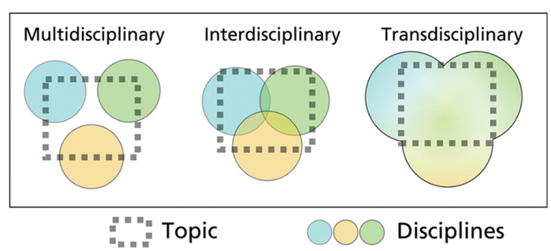
Image produced with Felipe Franco-Gaviria et al. (2022) within the framework of an interdisciplinary research project between paleoecology and anthropology in the context of the NERC Project: Bioresilience of Colombian Andean Forests.
By this, we aim to overcome the “epistemological divide of modern sciences,” that is the nature–culture dichotomy. The epistemological divide “nature–culture” not only separates disciplines and subjects of study but also connects them through hierarchical oppositional spheres. Methodologies and theoretical approaches in modern science have sustained this divide (Latour, 1999), which also attributes the character to the natural sciences, as the one that speaks for nature, and to the social sciences, as the ones that speak for human beings. The divide assumes that nature is neutral and independent from human history and that humans relate to nature by responding to restrictions but are independent of it. This divide underpins the epistemology of modern scientific methods and approaches and also what has been called “the science wars” (Latour & Noor, 2002) between natural and social sciences.
The epistemological nature–culture divide has been critically discussed in the social sciences, anthropology, and geography (Descola, 2005; Haraway, 2013; Latour, 2011), but also among biologists and physicists, who argue that both social and biophysical processes are produced in constant interaction (intra-action) and are mutually constituent (Maturana & Varela, 1980; Harding, 1992; Oyama, 2002). Therefore, building a heuristic approach based on transdisciplinary overcomes the nature–culture dichotomy and builds a research vision that focuses on the relationships, interactions, and mutual constitutions of nature and culture to understand the complexity of environmental change and peacebuilding.
Seeing from above helps to visualize the scale of problems through the power of quantitative data and maps, for example, deforestation, while seeing from below allows the recognition of new patterns and the interpretation of data. Linking different scales helps local communities on the one hand to visualize through seeing their position and role within a broader dynamic, but it seeks at the same time integrate local narratives into decision-making at an upper scale.
“Knowing” proposes second an ethic that intertwines the observer with the territory. It is the comprehension that the drivers of certain developments are not separated from but intertwined with and influenced by the narratives around one phenomenon. The substantiation of seeing into knowing thus consists of validating “data” through local narratives and working with local communities—it is necessarily a relational and in interactive practice. By substantiation of seeing into knowing, we accept that research becomes also part of situations on the ground. As a transformative act, knowledge creation seeks to enrich understanding of conflictive situations by working with communities to visualize their position at different scales and understand the interwoven dynamics alongside the integration of their narratives.
Using an interpretative and transdisciplinary heuristic does, on the one hand, not pretend to reach generalizations. But it enables us, on the other hand, to, first, overcome the nature–culture divide, and second, to understand “knowing” as a transformative action for EP. Consequently, research can only be based on interactive and participatory methods of research.
Methodology: Overcoming separate epistemologies on nature in Colombia
In line with the ontological and the local turn, the results we present here were based on participatory action research—an approach that highlights the inclusion of research subjects as “participants” and thus active co-producers of knowledge (Chevalier & Buckles, 2019). Local communities are thus systematically included as partners either in the definition of research objectives as well as an equal group when analyzing results. As described by Galeano et al. (2024), participatory action research follows a transformative agenda in that it not only empowers the inclusion of marginalized voices but also produces suggestions for action. de Sousa (2014) has pointed to “epistemologies of the South,” that are already existent and mostly come from the local. As suggested by Galeano et al. (2024), in practice this means “an openly transformative and hence political-activist research aim developed together with communities; trust in members of marginalized groups as capable researchers of their own realities; and the equal valorisation of academic and non-academic knowledges” (p. 3).
Thus, secondary and primary sources were used for seeing from above while the process of seeing from below was initiated in different interventions and research projects at the local level that are partially still ongoing at the time of writing. Fieldwork was implemented in Guaviare by the co-authors within different projects: The first on “Impacts of African Palm in the Northern Amazon,” an analysis of changes in the vegetation cover in the departments of Meta and Guaviare in 2021, funded by Green Livelihoods Alliance between 2021 and 2022. The primary sources were local stakeholders related either to deforestation activities in managing, protecting, or being affected: the authors conducted interviews with peasants, indigenous people, and Colombian government officials such as IDEAM, Vision Amazonia, SINCHI, as well as leaders from NGOs that operate in Guaviare, implementing community monitoring and deforestation analysis, such as Fundación para la Conservación y el Desarrollo Sostenible (FCDS), Fundación Gaia Amazonas (GAIA), Rainforest Foundation Norway. They also interviewed local environmental leaders from Community Action Boards and the Nukak Indigenous Reserve. Field visits were carried out for ethnographic observation between 2021 and 2022 during institutional workshops in San Jose del Guaviare and while providing support during situations of forced displacement of the Nukak indigenous people, as well as during events related to following of implementation of court decisions and sentences associated with the restoration of the rights of the Nukak people. Data and information were recorded in field journals, structured interviews, and databases. The information is encoded to ensure the participants’ safety and anonymity.
Though we explicitly do not seek generalizations, the case of Colombia is relevant for the wider study of EP and conflicts: it epitomizes the challenges of implementing EP initiatives in territories where there is more than one worldview about what we call nature. Here, conflict has settled and spread from different spatial and temporary scales, and armed confrontation has not only roots coming from social, economic, political, and resource/environmental disputes but also ontological differences in terms of expressing the persistence of coloniality of power in current conflicts.
Case study: Contested narratives on deforestation in Colombia
Colombia has a long history of peace processes with armed groups, particularly in the context of the Cuban revolution and the Cold War, beginning with the efforts of the Betancur government in 1982, the peace process with the FARC (Armed Revolutionary Forces of Colombia) in 2016, and the current efforts to negotiate a peace agreement with remaining rebel and dissident groups initiated at the end of November 2022 and in May 2023, respectively. Colombia has not been able to end its cycle of political violence of guerrilla warfare. On the contrary, these conflicts have mutated fueled by drug trafficking and illegal land grabbing, which has profoundly affected ecosystems and in particularly the Amazon forests, with annual deforestation levels of an average of 118312 hectares deforested in the Amazon’s northern frontier, a number sustained since the signing of the agreement with the FARC in 2016 (FCDS, 2022).
Nature and conflict in Colombia: Introducing deforestation in the Amazon
Armed conflict in Colombia can be traced back for more than 70 years as the result of the adjustment of modernity in Colombia and the structuration of the Republic under competing political interests (Thomson, 2011). The appearance of insurgent groups related to the fights for land tenure rights for peasants and the emergence of illegal drug production defined the systematic use of violence in the country from the early 1990s (Vargas, 2012). The recent period of conflict in Colombia has been delineated by the need to extend the production of illegal coca crops and the strategy of illegal land tenure by changing the soil used in extensive areas of Colombia, particularly the Amazon (Murillo-Sandoval et al., 2021). Recent conservation and management strategies have focused on ecological and quantitative descriptions, to design intervention policies related to peace and EP (Agudelo-Hz et al., 2023) but the outcomes are still poor considering the continued high level of environmental degradation.
In the Colombian Amazon, coca cultivation and deforestation are related. Illegal coca crop production and stabilization are recognized as major deforestation drivers in the Amazon in Colombia with significant negative impacts that can be perceived at local and international levels, such as biodiversity loss and greenhouse gas emissions. The report of the United Nations Office on Drugs and Crime (UNODC) “Monitoreo de territorios afectados por cultivos ilícitos (monitoring of territories affected by illicit crops) 2021” from 2022 states that Colombia is now the largest cocaine producer in the world, encompassing 70% of the world market. Therefore, after 40 years of war on drugs on Colombian territory, there have been no significant reductions in the production and export of cocaine—on the contrary, it has increased. The UNODC, however, shows a reduction in the areas planted with coca in Colombia. Nevertheless, cocaine production remains at the highest level in the multi-temporal analysis. This means that cocaine is now produced using less coca cultivation area than before, for multiple reasons such as the number of harvests, the height of the plant, and even investments in the scientific development of the plant by drug traffickers (UNODC, 2022). Also, the links between deforestation, coca production, and armed conflict are mostly context-dependent (Ganzenmüller et al., 2022).
Deforestation in Colombia appears connected to some legal and illegal activities, prompting the economic dependency of local actors on illegal coca production and distribution and the linked economic activities such as ranching, services provision, and transportation. The complexity of coca crop stabilization generates political instability, security issues, and the naturalization of the use of violence in Colombia related to unequal land distribution.
Coca cultivation, in addition to stimulating deforestation in specific planting areas, has promoted deforestation associated with the opening of transport routes for inputs and products associated with this activity. Coca plantations have negative environmental effects in that they involve deforestation processes, changes in vegetation cover, and the installation of one or several species in the area with effects on the ecological composition but also involve the use of fertilizers and chemicals for their cultivation and chemical inputs for cocaine production, which contaminate ecosystem services at the level of water sources and soils. What drives deforestation even more is the burning and grazing of pastures for cattle in the Amazon, which is largely driven by the circulation of drug money through money laundering and illegal economies, that is, in general terms, deforestation in the Colombian Amazon is driven by the political ecology of drug trafficking (Ballvé, 2012), rather than by coca cultivation alone.
Fifty percent of the coca cultivation is found within Colombia’s environmental conservation zones such as Natural Parks, Forest Reserves, Indigenous Reserves, and Black and Peasant Community Councils. These lands are either common public lands of the Colombian state or are under the collective ownership of Indigenous and peasant associations. In the Meta-Guaviare region, coca cultivation increased by 36% between 2020 and 2021 (UNODC, 2022). Despite the reductions in cultivated hectares observed in 2018 and 2019, an increase (similar in Caquetá) is observed for 2021, partly due to the lack of implementation by the Government of Duque of the PNIS program of substitution of coca crops for other livelihood strategies.
The sociocultural effects of coca plantations are associated with the asymmetrical power relations established by illegal armed groups. They control cultivation and production over the local population, peasants, and indigenous people. Local people who participate at the bottom in the coca plantation production chain, as raspachines, are under the control, surveillance, and subordination of illegal armed groups. Governance under the rule of law is suspended by the presence of illegal armed actors who in practice govern the territories and define aspects of daily life such as mobility, the supply of food and inputs, justice, other fundamental aspects of political participation, land use and ownership, and the recognition of the rights of indigenous communities and peasant organizations in autonomy. According to reports by FCDS (2020), local communities are subjected to extortion payments, threats, assassinations, forced displacement, and restrictions, such as curfews or armed strikes decreed by the illegal armed groups in these areas.
Conservation interventions in the Colombian Amazon are not new. The Amazon is perhaps one of the most important and representative places for global conservation. However, in Colombia, which is the fourth most important country in coverage of the Amazon biome, interventions so far have been fragmentary and patchy (Armenteras et al., 2019). Colombia is currently experiencing a political transition in the wake of the beginning of Gustavo Petro’s (2022–) presidency, which indicates a paradigm shift in understanding the importance of environmental conservation for ecological, social, and economic reasons, also to understands what is required to achieve peace, and how the fight against drugs has affected both peace and environmental conservation in Colombia. President Petro stated in the 2022 UN General Assembly that the war on drugs had been a failure since, after more than five decades of war, death, and violence in both producing and buying countries, the cocaine market has not been reduced but diversified and amplified while leaving death and human rights violations on both sides, without resolving the underlying social problems.
Seeing: Deforestation in the Amazon
The epistemic power of data and “seeing from above” finds resonance in a context like Colombia, which has been cycling through conflict for at least the last 50 years. The view from above has been controlled by the military but also by the illegal armed groups: guerrillas, paramilitaries, and the private armies of drug traffickers who have the economic resources to acquire satellite technology, planes, helicopters, and even drones to monitor, control, and punish localized people on the ground.
In the last decade, and in the context of the implementation of REDD+ (Reducing Emission for Deforestation and Degradation) programs for the reduction of CO2 emissions, in Colombia and several countries with strategic ecosystems, in particular tropical humid forests, institutional and knowledge structures have been put in place to monitor forests, their carbon sequestration capacity, and the progress of deforestation to meet the objectives of forest conservation and reduction of CO2 emissions. The implementation of these programs, which come from above, from global discussions on climate change, has brought Colombia a broader and more visible vision (literally and figuratively) of the forest, or as Colombians used to call it “the amazon jungles” before the arrival of the global forest conservation politics (Vandergeest & Lee Peluso, 2015). Thus, academics, researchers, environmental policymakers, media, and local communities increasingly relate to discussions of deforestation and the future of forests through satellite imagery and areal images, somehow eclipsing the possibilities of seeing and noticing the different narratives and life experiences that are inhabiting these forests (Bernal, et al., 2021; Vanegas-Cubillo et al., 2022). The power of the representation conveyed by satellite images has become so authoritative in Colombia that a great deal of deforestation and forest degradation monitoring is carried out using only satellite imagery, even as the most important basis for political decisions (Galindo et al., 2014). Map 1 provides a geographical overview of the deforestation dynamic in the Colombian Amazon region in 2020 (Table 1).
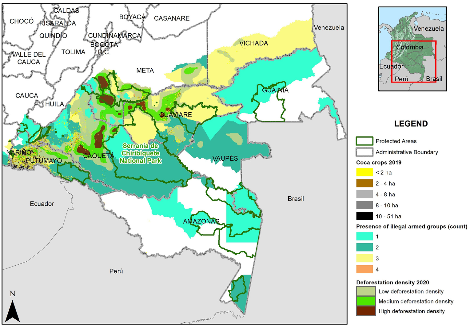
The Colombian Amazon (Amador-Jiménez & Millner, 2021, p. 10).
Annual and accumulated deforestation in the Colombian Northwest Amazon, 2016 to 2022 in the monitored area of 14.745.785 hectares.
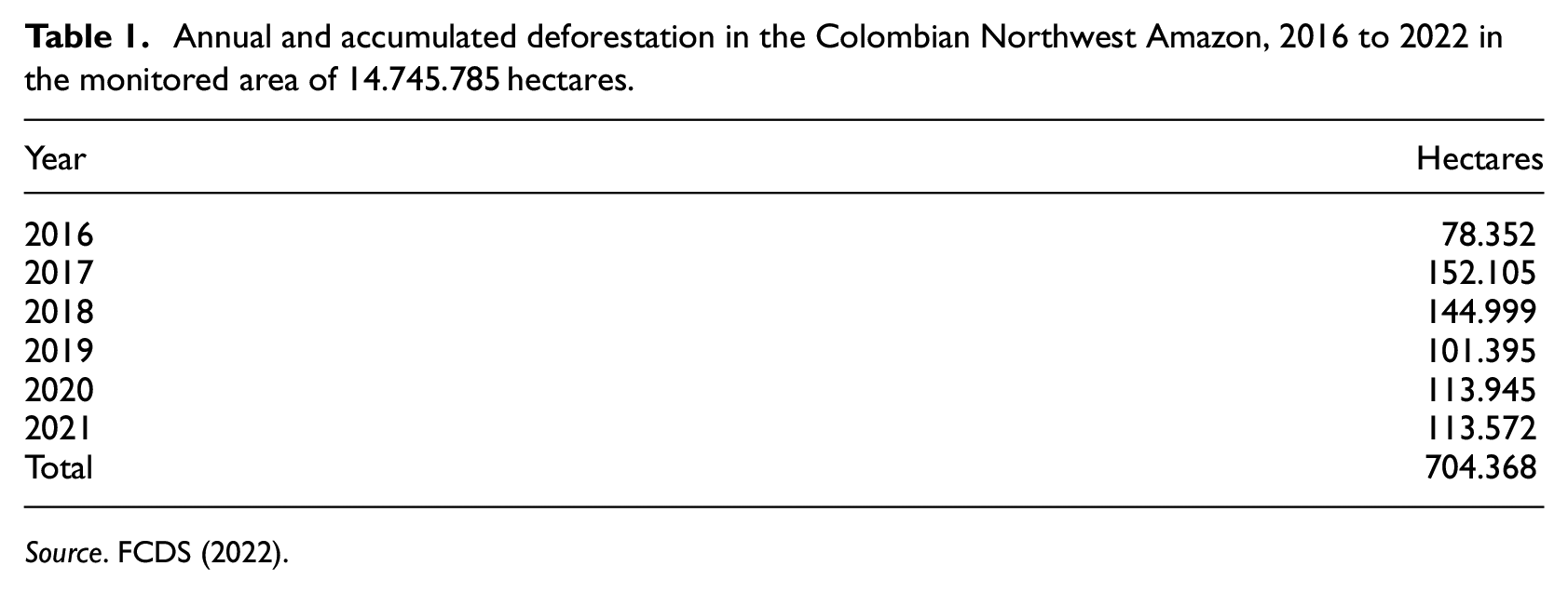
Source. FCDS (2022).
Guaviare is a region in Colombia that has experienced the guerrilla war, coca cultivation, drug trafficking, and the expansion of pastures by deforesting the Amazon. Guaviare is a territory where traces of the Andean, Orinocense, and Amazonian ecosystems converge. It is an area of interconnected biodiversity, where important river basins, such as the Guayabero and Ariari rivers, coming from the west and northeast, intertwine to form the Guaviare River. Protecting the forest in the Guaviare and its biodiversity is significant for the biophysical fauna and flora flows that compose the Amazon and the communities inhabiting it.
In Guaviare, there are four land management and conservation figures. The forest reserve zone of Law 2 types A and B, the Nukak indigenous reservation, the Nukak Reserve, and the north-eastern part of the Chiribiquete National Park, as well as a Campesino Reserve Zone (ZRC-Peasants Reservations Zones) that partially overlaps with the Nukak indigenous reservation, generating inter-ethnic conflicts. Within the protected forest areas are also villages with peasant communities that have formed spontaneously over the last four decades, where people do not have land titling and are invisible to the state. Map 2 shows not only the different indigenous reservations but also the high level of deforestation, specifically in the Nukak territory.
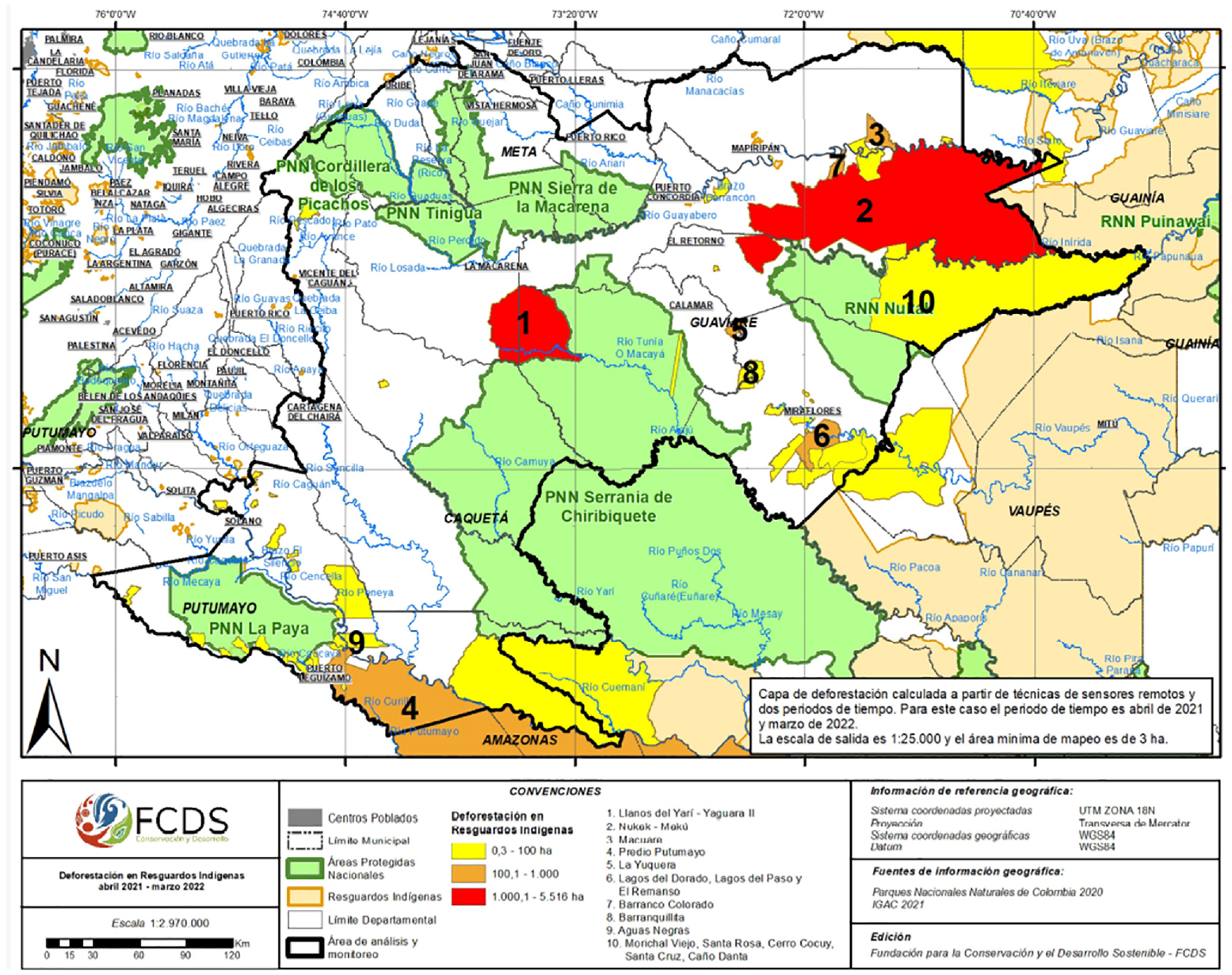
The Nukak territory and deforestation (FCDS, 2022).
In Guaviare, the issues of peace, deforestation, and the problems of cocaine production and distribution are concentrated. In this territory, at least until July 2022, the policy to manage these issues had been implemented forcefully through counterinsurgency warfare, reproducing the view from above of volumetric power, more specifically through operations such as Artemisa. Operation Artemisa proposed to combine cutting-edge satellite (GIS) technologies, planes to monitor deforestation, and military intelligence. Furthermore, in combining rhetoric of the fight against deforestation, the war on drugs, and counterinsurgency struggles, Artemisa framed people on the ground as threats and the internal enemy to be contained through military powers and rights of exception to control. Blurring the lines between the different “enemies” of state and nature and muddling the analysis thus allowed counterinsurgency to be continued under another name (Amador-Jiménez et al., 2020). 2
Knowing: Narratives on deforestation
The coca-deforestation narrative in the Nukak territory
The cultivation and processing of cocaine in specific sectors, such as in Guaviare and in particular in the Nukak resguardo, does generate high impacts in terms of deforestation, environmental degradation, and sociocultural decomposition, which, in turn, impacts the Amazonian sociocultural complex, such as those developed for centuries by the indigenous, nomadic or stationary groups that have terraformed the Amazon (Morcote-Ríos et al., 2021; Raffles & WinklerPrins, 2003): There are records of the existence of coca crops in the Nukak reservation since 2001, when there were around 640 ha of coca. Since then, the area under cultivation increased by 386.69 new hectares to reach 1,027.16 ha in 2003, which represents the maximum peak until 2020. By 2004, the area planted decreased to 530.99 ha, from that year until 2009 the area planted remained relatively constant until 200. (FCDS; Observatorio Amazonia, 2023)
Coca cultivation within the resguardo does not exceed 3 hectares and consists of small, scattered crops. In the Nukak Nature Reserve adjacent to the Nukak Resguardo, the average size of coca fields is 1.3 hectares. The coca fields near the reserve are fragmented and do not exceed 5 hectares in size. Few plantations are larger than 10 hectares but these have infrastructures for the production of coca paste but, although being observable through satellite images, they have not been visible in the low-altitude overflights.
Between 2018 and 2020, a total of 38 km of new roads were built in cattle and coca production areas within the Nukak Resguardo. The loss of forest cover in the road parallel to Caño Maku and Caño Mosco is evidence of this, as well as the recent deforestation associated with coca within the resguardo on the banks of the Inírida River and in the sector of Caño Canchina. The strategy of the fight against drugs through the counterinsurgency war and practices such as spraying with glyphosate have contaminated the soil and water sources, intensified the conflict, and affected the health of the Nukak indigenous community.
The Nukak indigenous people have been involved in the chain of the production of base paste and cocaine hydrochloride in Guaviare as raspachines, mainly by peasants who grow coca and produce cocaine (Alferez Romero & Garzon Rojas, 2022). Though this involvement has been portrayed as “voluntary,” it was forced by the conditions of integration of indigenous people into Colombian society, a process that has been subject to violence, discrimination, racism, stigmatization, marginalization, and contempt for indigenous worldviews and relationships with the amazon forest. State institutions have been negligent in understanding the Nukak situation, and armed groups have violated their human rights, particularly the FARC-EP and other illegal armed groups. Less than 500 people of this nomadic indigenous group are still alive today, which brings their situation close to an ethnocide (Mahecha & Franky, 2012).
Our involvement in decoloniality and transdisciplinary aims to highlight power relations, winners and losers in deforestation due to coca cultivation in Guaviare but also to reveal the invisible, marginalized worlds and the dispossession that often goes unnoticed. To be seen, this requires mixed sensitivities, which involve seeing from different perspectives and integrating various methodologies, including the ways of seeing the Nukak people. A few impressions from ethnographic fieldwork shall illustrate this: A group of Nukak from Charras arrive in San José, the young men organize a temporary camp in the village’s main stadium. They tell me that they have left the village because the peasants from the community action board warned them about the arrival of the paramilitaries. A few hours later, the ombudsman’s office arrives to deliver boxes of food (bread, sugar, panel among other groceries). They were frightened by what the peasants told them. However, there are no paramilitaries in this territory. This is an example of a territorial dispute between peasants and landowners against the Nukak, their world, their indigenous reserve and their right to territory. At the handicrafts festival in San José del Guaviare, the Nukak have a corner where they sell their hammocks, baskets and handles, handicrafts produced by the women, while the men press the women to get the money. The women demand autonomy and security. Coca, deforestation, and violence by armed groups have degraded gender relations, and the co-communal bodily relationship of Nukak cosmology. Children are visibly sick, with lacerations on their bodies, and one woman tells me of the rape of two girls in Puerto Flórez by a group of young Nukak men. This is the area of major disputes and movement of arms, drugs, and land grabbers in Nukak territory. (Fieldwork notes)
The deforestation and dispossession of the Nukak reserve by large land-grabbers is only the surface of the degradation and extinction of the Nukak people that is devouring themselves and their sense of connection between boy-people-community and territory.
The people who work in the coca plantations are subjected and subordinated through an excessive and violent unregulated production complex that degrades the indigenous individuals through drug addiction and prostitution. It distances them from gathering, hunting, and fishing practices, which deteriorates the long-term indigenous practices as it leads to the loss of knowledge about gathering sites and the generation of hunting and fishing skills. Furthermore, it degrades sociocultural relations in the Nukak groups, as it generates intergenerational conflicts over access to money, products for consumption, and coca paste, and intra-familial, gender, and sexual violence resulting from access to money, the power of belonging to a coca-gathering gang, interaction with mestizos and peasants, and rape of minors and women by young Nukak men working in the coca plantations (Politis, 2009). Coca plantations constitute a condition that directly affects the physical and sociocultural extermination of the Nukak people (Constitutional Court Auto 004 of 2009).
The dynamics of coca cultivation and deforestation in the Nukak territory could not be understood only by seeing from above, in terms of collecting satellite data. Seeing from below allows the researchers to intertwine with the territory, and get closer to the daily relations of the Nukak with the coca, and the relations of subordination to which they are subjected. Seeing only from above enables superficial conclusions such as the Nukak were also drug traffickers and contributed to deforestation, lending legitimacy to environmental military operations like Artemisa and the spread of glyphosate on the coca crops, affecting the health of the indigenous groups, peasants, 3 and the ecosystem of the Amazonian tropical forests of Guaviare.
The fieldwork with the Nukak people, the exploration of their territory by walking with them, and accompanying the hearings and activities in which they meet with institutional officials give us a different and more complex dimension of the deep webs of violence in which the Nukak are subjected, so by seeing from above with them, the Nukak people re-appear not as the deforesters of the Amazon for growing coca, but as historical victims of colonialism and colonization of the Amazon but also as a human group whose sociocultural practices can no longer be restricted to a resguardo, as if they were a museum piece, but as a living group that adapts and learns new cultural practices in the complex context of war and colonization in the Colombian Amazon.
The land colonization–deforestation narrative
Road development is considered one of the main needs for economic development around the world (Fondo Mundial para la Naturaleza (WWF), 2020), but also a driver for the deforestation factor (Nepstad et al., 2001). Based on Colombian topography as well as lack of government investment, many rural areas are connected by what are called tertiary rural roads which are, in many areas, built up combining the local community’s labor and investment mixed with local institution’s budget (IVV, 2020). Many of the country’s tertiary roads are located in areas designated as priorities for the conservation of biodiversity or traditional indigenous communities, affecting the local ecosystems and livelihoods and acting as drivers directly supporting deforestation (INGETEC, 2020). Secondary and tertiary roads represent 80% of the road network in Colombia (CONPES 3857) and many of them have been built without environmental assessments and their quality is extremely poor. Also, some roads have been constructed along illegal extractive activities mostly related to coca production and distribution.
In San Jose del Guaviare, particularly in the Miraflores municipality, a road was built roughly 40 years ago in one of Colombia’s most impressive coca bonanzas. Based on local informants living for more than 50 years there, the construction of the road was planned and executed with money from coca producers and maintained and enhanced by the FARC and it is still highly used by coca producers and illegal actors but also constitutes the only way for local inhabitants to have affordable access to the center of the country and legal agricultural markets. The main objective of the road was to connect the municipalities of Calamar and Miraflores to warranty the circulation of agricultural inputs and to control the distribution of coca leaves mostly to the United States (Camacho Peña, 2022). The creation of this row initially helped illegal crop trafficking but also solved many of the access limitations based on the lack of transport facilities at the Amazon in Colombia. The maintenance of the road has been mostly financed by coca crop producers as well as ranchers, and other users with less economic capacity participated with the labor force. Over the last few years, road use has been recognized as a driver for the loss of local forests since it facilitates penetration into the forest’s matrix, allowing and consolidating the occupation, installation, and transport of coca crops, livestock, and the mobilization of armed groups (Camacho Peña, 2022).
In 2010, Miraflores had 1.10 mHa of tree cover, which extends over 98% of its land area. In 2021, it lost 1.78 Kha of tree cover, equivalent to 1.26 Mt of CO2 emissions. The loss of primary forest in Miraflores Guaviare from 2001 to 2021 was 20.4 Kha of primary tropical rainforests, representing 61% of its total forest cover in the same period. Likewise, in terms of tree cover, in Miraflores, from 2001 to 2021, 33.4 Kha of tree cover was lost, equivalent to a 3.1% decrease in tree cover since 2000 (Global Forest Watch, 2021) (Figure 2).
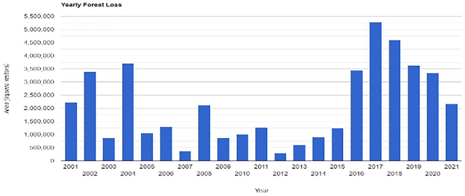
Loss of forest from 2001 to 2021 in Colombia.
The region Meta-Guaviare ranked fifth in 2021 among the regions with more area dedicated to coca crops with roughly 6.075 hectares producing 3% of the coca for the country, it showed an increase of 36% compared to 2020 and 70% coming mostly from El Retorno, Miraflores, and San José del Guaviare (UNODC, 2022). The most worrying deforestation points, according to the FCDS (2022), are in the sector that connects the municipalities of El Retorno and Miraflores. There, 432 open instances of deforestation were registered, totaling 2,599 hectares, located in the Agua Bonita Media village, which was expanded by the road that connects the populated centers of Calamar with Miraflores and connects perpendicularly with new road axes toward the villages (FCDS, 2022).
The open ones due to deforestation correspond to areas of at least 0.3 continuous hectares of lost forest. These are detected in the monitoring and interpretation of satellite information and low-altitude overflights. This value corresponds to the minimum unit that can be mapped, which for the period of April 2021 and March 2022 was taken from 0.3 hectares. Considering these values, FCDS identified 15,936 continuous open deforestation areas, distributed as follows over the municipalities of the Amazon, evidencing that the municipality of Miraflores has fewer deforested hectares than El Retorno.
The rising of coca leaves production and distribution in Miraflores can be explained by the permanent financial support from national and international illegal groups since the incomes are almost double that of other legal products, and the perception of the economic improvement of livelihoods conditions. This situation, particularly the idea of well-being related to access to goods and services, decreases the perception of local inhabitants of the negative impact of coca production and limits their capacity to recognize the increase in deforestation locally. Based on interviews, the local inhabitants consider that the negative impact of coca crops was way higher about 20 years ago, and producing coca is a “necessary evil.” Over the last 3 years, coca production and transformation decreased, related to the COVID-19 mobility restrictions in Guaviare and Miraflores.
Based on quantitative information coming from ecological assessments and remote sensing, in 2019, the nation’s attorney general ordered a protection precautionary measure aimed at protecting the environment by closing the Calamar-Miraflores road, blocking the use from local actors generating negative economic impacts and the discontent of local inhabitants. Until today, the use of the road is restricted, and based on several local interviews, the local communities consider the environmental protection measures a tool against them and their needs.
The normative restriction coming from decisions taken after GIS analysis exhibits the paradox between viewing from above, and the impact that protecting the environment shows for local inhabitants and local narratives. For local communities, this situation has reinforced the perception that deforestation “happens somewhere far from the community” and they act mostly like victims. In general, deforestation levels are considered low or not too negative based on the relationship between deforestation and economic income. Likewise, deforestation is a minor problem for them, compared to the negative impacts related to restriction to health services, education, and mobility coming from the precautionary measure restricting road use.
However, when having focus groups locally, the GIS analysis and the use of maps changed the perception of participants, moving from “it happens far from us” to “we recognize coca crops are increasing deforestation, but we have no other economic sources,” and even to a more complex perception of the presence of deforestation and it impacts. Seeing from above might help to explain better deforestation trends to different stakeholders but hardly itself replace locally adapted solving strategies.
From the political ecology perspective, this situation exhibits a possibility to build bridges between what is called “Global Environmental Management (GEM) discourse” calling for more intervention and placing the solution as a restrictive normative one, and the “populist discourses” placing deforestation as a marginalization mechanism (Adger et al., 2001). Based on that, also using the maps as a source in Miraflores, the local narrative starts to define that, they cannot fight against deforestation directly but they can participate in projects related to ecological restoration in some areas that belong to them and have been used in the past for coca production. They recognize solving the problems related to deforestation is not possible for them, but when realizing the evolution of deforestation locally and in Guaviare, their narratives shift to acknowledging their need also to have a healthy environment. Coming then from the technical GIS narrative, and the local possible explanations for deforestation but also its impacts, local communities have increased their participation in political decision-making in parallel with local environmental stakeholders.
Conclusion: Community-based solutions for environmental conflicts
Combatting deforestation in the Colombian Amazon has been linked on a global scale to the fight against climate change and the rescue of the planet Earth. EP thus stands for a concept that addresses the need to take environmental protection into account in initiatives for conflict resolution at the local level in Colombia. It is well recognized in the literature that the integration of communities is a pre-condition to avoid negative externalities of both natural conservation projects and peacebuilding initiatives (e.g., Hachmann et al., (2023). However, more often than not, political measures and interventions are based only on one-sided data and perspectives, often mirroring academic disciplinary divides and eclipsing local narratives, as Ansari et al. (2023) have shown in a meta-analysis on communication with local communities across the globe. Even if the calls for transdisciplinary research projects and the transfer of decolonial approaches to environmental sciences are now widespread (Ansari et al., 2023; Verran, 2002), more often than not the answers by academicians and practitioners alike are merely “communicative” and do not question the basic conceptual underpinnings between “North” and “South” (critical: Ducarme et al., 2021; Whyte 2020). We go a step further and propose a transdisciplinary heuristic based on an inductive logic aiming to closely link the concepts of natural and social sciences and integrate different ways of “seeing.” The general motivation guiding this paper comes thus from the recognition of the limitations of single descriptions of complex problems such as deforestation, and how it reduces the possibility of implementing EP strategies far from the risk of hiding key actors or eroding local governance structures. Finding convergence on different temporal and spatial scales of observation thus leads to the emergence of an integrated way of “seeing” environmental conflicts (from above and from below). However, to overcome the culture–nature divide, experiences, and narratives expressed by the local people and their local knowledge need to form the basis for this process. Our paper strengthens decolonial approaches to knowledge production and addresses asymmetric power relations and epistemic hierarchies in global research to stop deforestation. Thus, our heuristic can help improve EP initiatives as a transformative action by integrating spatiotemporal dynamics through data, local narratives, and sociocultural practices. Concretely, deforestation has different “meanings”: it is framed as a key climate change challenge but it also does represent local economic opportunities for small-scale economic like cattle ranching. Thus, tackling deforestation alone will not change the problem but rather EP shall consist of programs like decriminalizing coca and community forestry. Better linking science about nature to citizens and with local people—those affected and living in nature—is, however, not only an imperative for conflict-ridden regions in the Global South but should well be integrated into research programs across the globe and in the Global North.
Footnotes
Funding
The author(s) disclosed receipt of the following financial support for the research, authorship, and/or publication of this article: Research for this paper profited from funding by the German Research Foundation (DFG) within the framework of the Heisenberg Program for Solveig Richter.
Data Availability Statement
For our quantitative data, we relied on publicly available statistics (for references see text). For our qualitative data, we relied on anonymous interviews with members of indigenous communities. These interview data cannot be published to protect the anonymity of our interview partners.