
Abstract
In this paper, we seek to understand the practices that shape nature into governable objects by exploring the different framings of coastal heathlands and the political technologies that inform their governance. Through investigating national policy objectives alongside related management practices – and drawing on a case study from western Norway – we explore how conflicting values and aims may emerge in the governance and stewardship of these landscapes. Coastal heathlands are designated as a selected habitat type in Norwegian policies and are, therefore, subject to special consideration in land use decisions. There appears to be a joint understanding locally, regionally, and nationally that these habitats are best conserved through the prevention of reforestation and the maintenance of openness via grazing and burning. However, there is less coherence regarding how heathlands are defined and which areas qualify as such. The scientific and administrative propensity to categorise nature masks the mosaic of habitats that make up the landscapes and the local meanings attached to them. This contrasts with local land users’ alternative makings of the landscape, rooted in traditional practices. Furthermore, we find that policies of nature conservation and agriculture offer competing incentives for stimulating or disciplining farming practices. This jeopardises the voluntary engagement by landowners and farmers, which is crucial to sustaining these landscapes and their diverse values. The political technologies used to define and make sense of nature form the coastal heathlands as an object of governance. We show, however, that the tools and the knowledge systems used by authorities to define and justify conservation needs may, paradoxically, hinder more integrated approaches to conservation.
Introduction
Coastal heathlands represent landscapes of rich and layered value. Characterised by a mosaic of open plant communities dominated by heather (Calluna vulgaris), these landscapes are ecologically distinctive and culturally significant. They provide a wide range of ecosystem services, including habitat for threatened species, soil formation, carbon storage, low-input meat production, and heather honey. Beyond their ecological and agricultural importance, coastal heathlands are deeply embedded in cultural history, valued as recreational spaces and recognised as part of a shared European cultural heritage (Kaland and Kvamme, 2013).
In Norway, coastal heathlands tend to be explained and managed as a semi-natural ecosystem and a cultural landscape (MCE, 2015; Meld. St. 35, 2023–2024). The Great Norwegian Encyclopedia defines cultural landscapes as being “wholly or partially transformed from their original natural state due to human activity”, and this “includes rural, urban, and industrial landscapes” (Bruun and Falk, 2023, our translation). However, according to the typical Norwegian understanding of cultural landscapes, they are landscapes and vegetation influenced by traditional, extensive forms of farming. The notion of cultural landscapes gained traction in Norway in the 1960s as a reaction to the perceived effects of urbanisation, agricultural rationalisation, and depopulation of the countryside (Jones and Daugstad, 1997). By the 1980s, the notion was commonly used across various academic disciplines and administrative sectors, albeit in diverse ways “reflecting different value loadings” (Jones and Daugstad, 1997: 277). A systematic analysis of Norwegian and Nordic policy documents conducted in 1993 revealed that the agricultural sector embraced the concept of cultural landscapes to justify new agricultural investments (Jones and Daugstad, 1997: 273). In the nature conservation sector, however, the concept was used to emphasise semi-natural ecosystems and the biodiversity they harboured, while in the cultural heritage sector, the focus was on historic buildings and structures while also highlighting the importance of cultural landscapes for identity.
The diverse meanings attributed to landscapes are neither novel nor particular to Norway. Rather they reflect a broader scholarly interest in the landscape concept across disciplines, with varying emphasis on its symbolic, aesthetic, and representational dimensions (for a review, see for instance Anderson, 2003; Germundsson et al., 2022). Olwig (1996: 630–631) argues that landscapes should be seen as contested territories of habitation and interaction, perceived as “a nexus of community, justice, nature, and environmental equity”. This resonates with Ingold's (2000) dwelling perspective, which conceptualises landscape as a process continually shaped through everyday practices and activities. The temporality of the landscape, according to Ingold, is embodied in “the lives and works of past generations who have dwelt within it […] and left there something of themselves” (2000: 189).
The European Landscape Convention of 2000 adopts the term landscape without distinguishing between what is natural and what is cultural (Council of Europe, 2000). According to Sodano (2017: 83), the convention deliberately avoids the term cultural landscapes, instead defining landscapes as “an area, as perceived by people, whose character is the result of the action and interaction of natural and/or human factors”. This definition highlights the central role of human agency in landscape matters, particularly the influence of those “whose daily practices and perceptions shape the social and physical landscape” (Olwig, 2007: 581). In the context of Norwegian cultural heritage policies, Hjemdahl (2023) discusses how the nature-culture relations embedded in the concept of cultural landscapes (and other forms of cultural heritage) have been framed as environmental issues and consequently governed by the Ministry of Climate and Environment according to the logic of natural sciences. As a result, landscapes are rendered governable through knowledge practices that make them legible to decision-makers – for example, through the production of facts about key sites via the process of registration, systematisation, valuation, and mapping.
The shifting understanding of landscapes – as both materially shaped and symbolically loaded – highlights the inherent tensions in managing environments like coastal heathlands. As concepts of nature, culture, and heritage intersect, the governance of these landscapes becomes entangled in competing priorities, administrative logics, and epistemological frameworks. While policies may frame heathlands as semi-natural habitats and elements of cultural heritage, local practices and perceptions often reflect more diversified values and relationships with the land. This disjuncture raises important questions about whose knowledge informs landscape management, how value is assigned, and what is ultimately at stake in conservation efforts.
Acknowledging these tensions, this paper explores the ambiguous meanings of coastal heathlands and the knowledge technologies that inform their governance. Through a case study of coastal heathland conservation on the western coast of Norway, we examine how national policies for coastal heathland conservation mesh with local landscape practices. In doing so, we discuss inconsistencies between what counts as valuable, desirable, or otherwise worth caring for in policies, on the one hand, and practical implementation of the same policies, on the other. We argue that conflicting policy rationale and techniques used to manage nature and incentivise farmers and landowners to preserve the landscape, create challenges for the governance of coastal heathlands.
In the following sections, we present the theoretical framework and the methods used and lay out key national policies addressing coastal heathlands before discussing their local conservation efforts. Lastly, we discuss the consequences of these governance arrangements for long-term landscape stewardship.
Making nature governable
To investigate the knowledge technologies involved in making the coastal heathlands governable, we draw on the concept of governmentality and a body of scholarship informed by Michel Foucault's notion of government as the conduct of conduct – that is, the structuring of the possible field of action of others (Foucault, 1982). Governmentality can be explained as the process that occurs when someone, for example, an authority, by more or less calculated means, shapes, guides, or affects human behaviour so that people, “following only their own self-interest, will do as they ought” (Scott, 1995: 202–203, italics as in the original). Interpretations of a governmentality framework have been applied to a range of fields and issues, including the management of cultural heritage (Coombe, 2012) and landscape conservation (Silva, 2015; Waage and Benediktsson, 2010). In placing our research within such a framework, we draw further inspiration from Tania Li's work on development through government interventions and Kristin Asdal's research on how nature is formed through technical, scientific, and administrative practices. Underpinning such an endeavour is an insight that our ways of understanding and knowing the world are intimately linked to the ways we seek to organise, control, and govern it (Jasanoff, 2004).
To study the art of governing, Li (2007a) proposes examining the objectives of the governing actor, how issues are problematised, and the outcomes they seek to achieve. This involves analysing the strategies and techniques deployed to realise these aims – what Asdal (2008a) refers to as the technologies of politics. Such techniques are designed to shape conduct and induce particular forms of behaviour within a population, aligning with Foucault's (2008) notion of discipline. According to Li, these types of interventions demand their own form of knowledge, which is produced through two interrelated practices (Li, 2014). The first, problematisation, involves identifying perceived deficiencies or weaknesses in existing systems that require correction. The second, rendering technical, entails reframing these deficiencies as issues that can be addressed through scientific and technical solutions (Li, 2007b). Li illustrates this with the example of statistics, which enable the state to detect patterns in areas such as health or the economy, thereby facilitating targeted interventions aimed at optimising the well-being of the population. However, she argues that such knowledge is constrained by the limits of what is measured, producing a simplified model of the world – one that can be controlled, developed, and improved (Li, 2005). This constructed model, in turn, shapes assumptions about which governance measures are appropriate or necessary to achieve desired outcomes. Li's analysis resonates with James C. Scott's (1998) critique of state-driven efforts to render society legible through the simplification of complex realities and the privileging of “observations of only those aspects of social life that are of official interest” (Scott, 1998: 80).
Asdal similarly argues that our understanding of nature and how it should be managed is shaped – and constrained – by scientific and bureaucratic procedures and practices (Asdal, 2004). These are part of what she refers to as techniques for the governing of nature, which also involve disciplining and enrolling the public (Asdal, 2004, 2008b). She emphasises how little tools of knowledge – such as images, graphs, lists, questionnaires, dossiers, tables, and reports – structure the terms of participation in environmental management and thus play a significant role in shaping policy and decision-making (Asdal, 2008b). On the one hand, a focus on technical tools and budgets tends to de-politicise environmental issues by framing them as just a matter of administrative procedure. On the other hand, these same tools and budgets determine whether and how a phenomenon becomes a political issue (Asdal, 2008a). To understand how science, technology, and politics intersect in producing, rendering real, and making nature governable, Asdal calls for attention to the everyday practices of bureaucracy and administration (Asdal, 2004, 2008a). She emphasises the central role of policy texts and written documents as political technologies. Empirical studies of such texts offer insights into the rationales underpinning environmental policy, how certain issues come to be defined as relevant, and the use of monitoring, calculations and estimates in transforming nature into an object of governance (Asdal, 2004). These perspectives on governmentality and the political technologies of environmental governance inform the research objectives we now turn to.
Research objectives and methods
The objective of this paper is to assess how political technologies and practices render coastal heathlands governable, and how national conservation policies interact with local landscape practices. The analysis is guided by three research questions: (1) How do political technologies shape the governance of coastal heathlands? (2) How do local land users understand and engage with these landscapes, and how do their perspectives align or diverge from scientific and administrative framings? (3) How do competing policy incentives influence farmers’ engagement in landscape stewardship?
Active landscape maintenance can be understood in different ways, and different terms are commonly used, such as management, caretaking, upkeep, or stewardship. In this paper, we will use the notion of stewardship as the equivalent of the Norwegian term skjøtsel.
The study was conducted at Værlandet-Bulandet, the westernmost inhabited archipelago in Norway, with approximately 450 people (Thorsnæs et al., 2024). A significant part of the largest island, Værlandet, is considered a nationally valuable heathland landscape that includes crags, mires, heathlands, and lakes. This landscape has been developed through the traditional land use practices of the fisher-farmers, who supplemented their fishing activities with small-scale farming. Thus, many island inhabitants used to keep some sheep and cows, historically a common livelihood strategy along most of the coast of Norway. Nowadays, important industries in the archipelago are commercial fishing, fish farming and processing, quarrying, and tourism (Askvoll Municipality, 2017). Extensive sheep grazing is still carried out on large parts of Værlandet, and although it does not involve many people, it is a critical activity in terms of land use. Some landowners on the islands also engage in landscape maintenance supported by the authorities.
Data for this study were collected through multiple field visits to the island community between 2019 and 2023. A total of 34 interviews were conducted with 29 individual informants, all of them carried out in Norwegian. All interviews were carried out in person and conducted by one or two researchers from the team. Of the total number of individual informants, there were 17 men and 12 women. 13 interviews were done with local actors, with a particular emphasis on people directly engaged in landscape management practices, such as farmers and landowners. As the study area is a small island community, it was a helpful starting point for us to map and attempt to recruit all the prominent actors in land maintenance and agriculture at the archipelago. Three of the local farmers were interviewed several times throughout the duration of the project. Additionally, we tried to cover other important local activities by interviewing people (12) involved in aquaculture, fisheries, tourism, and community development. Five interviews were carried out with local and regional authorities with responsibilities pertaining to agriculture and environmental management. Three interviews were conducted with experts in botany and biology who had mapped the biodiversity and the cultural-historic nature values of this specific locality from the 1990s onwards. Most of the interviews were semi-structured, whereby an initial set of questions provided an avenue for reflections by the interviewees. 11 of the interviews were framed by a Q-methodology (Barry and Proops, 1999). For purposes of this article, the quantitative data produced by this method has not been utilised, but the reflections generated by these interactions provided additional perspectives and were helpful in corroborating data from the other interviews.
The study was supplemented by analysing key documents at different scales of government (national, regional, and local). The chosen documents for our analysis were identified by tracing from below the policy frameworks and scientific reports that were important in establishing the case-locality of our analysis as a heathland of national importance. Based on a search amongst the current national legal acts and government white papers issued between 2015 and 2024, we also traced from above. We found three governmental white papers that referred to ‘coastal heathlands’ (Norwegian: kystlynghei). The national policy documents are what we will turn to next.
Political technologies shaping the coastal heathlands
Through categorisation, mapping and policies, coastal heathlands are made into governable objects. This section looks at these technologies and – following Li (2007b) – what objectives or needs they are set to address, and how they seek to shape the conduct of local citizens.
With an increased awareness of the threats to coastal heathlands, they were categorised as endangered in the Norwegian Red List of Habitats in 2011 (Hovstad et al., 2018; Miljøstatus, 2023). Coastal heathlands were put higher on the political agenda in 2013 with a knowledge synthesis conducted by Kaland and Kvamme (2013) and a related national action plan for the coastal heathlands (DN, 2013). The knowledge synthesis described 23 locations, representing the regional variation in coastal heathlands, and the action plan laid out key measures for preserving the heathlands. Based on the recommendations in these two reports, the Norwegian government decided in 2015 to recognise the most valuable coastal heathlands as a selected habitat type. This was done according to the Nature Diversity Act of 2009, which has as its primary objective “to protect biological, geological and landscape diversity and ecological processes through conservation and sustainable use” (MCE, 2009). The Act was expanded in 2011 with a decree on selected habitat types, which since 2015 has included coastal heathlands (MCE, 2011). This designation grants coastal heathlands special protection in land use decisions, recognizing their ecological and cultural significance. Out of the eight habitat types given status as selected habitat types, three are found in traditional agricultural landscapes and rely on active maintenance: hay meadows, hay fens, and coastal heathlands (Miljøstatus, 2023).
While an act is legally binding, a white paper is an in-depth report on a specific topic issued by the government to inform the parliament about work carried out in a particular field and propose future policy actions. The white paper “Nature for Life – Norway's National Biodiversity Action Plan”, published by the Ministry of Climate and Environment (MCE) in 2015, concerns policy perspectives on biodiversity conservation. The paper recognises coastal heathlands as semi-natural habitats within the cultural landscape that need targeted conservation and management efforts (Meld. St. 14, 2015–2016: 54–55). It argues that “the main threat to most species and habitats in the cultural landscape is the discontinuation of active use (grazing and haymaking), followed by overgrowing of the open landscape” (Meld. St. 14, 2015–2016: 54). The white paper recognises intensification of agriculture, conversion of agricultural areas for other purposes, and invasive alien species, as threats to cultural landscapes. Moreover, it points to the need for incentives that stimulate outfield grazing and that different livestock species and breeds graze differently. For example, grazing by sheep and goats minimises forestation and, thus, positively affects biodiversity dependent on open landscapes. As such, the white paper recognises the role of extensive agricultural practices in maintaining the values of cultural landscapes.
The most recent white paper on policy perspectives on agriculture, “Change and Development – a Future-oriented Agricultural Production”, was published by the Ministry of Agriculture and Food in 2016 (Meld. St. 11, 2016–2017). The paper refers to coastal heathlands as a habitat type conserved through the maintenance of cultural landscapes. The white paper acknowledges that the habitats of cultural landscapes depend on extensive land use practices, but its primary focus is on intensifying agricultural practices. The environmental policies emphasise the conservation of coastal heathlands as endangered semi-natural habitats, requiring extensive and low-intensity land use like grazing to prevent overgrowth and preserve biodiversity. In contrast, agricultural policies, while acknowledging the conservation value of these landscapes, prioritize the intensification of agricultural production, which can undermine the extensive practices needed to maintain coastal heathlands. This creates a conflict between the goals of biodiversity conservation and agricultural development.
A third white paper, “New Goals for Norway's Cultural Environment Policy” issued by MCE in 2020, addresses a third aspect of coastal heathland management: the role of local citizens (Meld. St. 16, 2019–2020). It declares that cultural and natural heritage are interlinked and play essential parts in people's identity, quality of life, traditions, and knowledge. Further, the paper acknowledges that the existence of many of these environments is premised on the commitment and dedication of private owners and volunteers.
Recognising the role of local stewardship, the national policies provide a variety of measures to realise heathland conservation, such as economic incentives. A case in point is the national environmental programme for agriculture, an economic scheme to facilitate the preservation of a wide range of landscape types, valuable biotopes, and cultural environments. The measures of this programme include both general subsidies to ensure the continuation of land use and more targeted subsidies for preserving environmental qualities that require special agricultural practices. For example, farmers can apply for financial support for keeping animals that graze certain cultural landscapes (Meld. St. 11, 2016–2017: 127). In addition to the national environmental programme for agriculture, there are regional and local programmes. The Regional Environmental Programme (Regionalt miljøtilskudd i jordbruket, RMP) is an annual grant to maintain specified agricultural practices. The Special Environmental Measures in Agriculture (Tilskudd til spesielle miljøtiltak i jordbruket, SMIL) are limited to supporting stand-alone investments, like restoration or clearing, and are not for continuous maintenance (Meld. St. 11, 2016–2017; Østebrøt and Betten, 2009). The Norwegian Agricultural Agency (NAA) governs all the programmes, though the RMP and SMIL are administrated regionally and locally.
The Norwegian Environment Agency (NEA) governs economic schemes that help safeguard locations defined as nationally valuable cultural landscapes and threatened habitat types (NEA, 2022, 2023a, 2023c). Funding from NEA supports the restoration and management of protected areas, threatened habitat types (such as ‘selected habitat types’), or locations included in the national inventory of selected cultural landscapes. In addition to the sector-specific programmes, there are also grants for managing Agricultural Landscapes of Special Interest. This is a joint initiative between NEA, NAA, and the Directorate for Cultural Heritage (NAA, undated). As with the other schemes, the purpose is to incentivise farmers and landowners to preserve cultural environments, biodiversity, and agricultural practices (Meld. St. 14, 2015–2016; Meld. St. 16, 2019–2020; Øian and Rønningen, 2013).
Another form of measure to realise heathland conservation is designating landscapes with coastal heathlands as protected areas. In accordance with the Nature Diversity Act, protected areas are regulated through management plans that ensure their ecological integrity. Where active use or stewardship is needed for maintaining biodiversity (such as for the coastal heathlands), the Act mandates the development of action plans detailing how conservation efforts should be carried out. Local landowners and rights-holders are encouraged to voluntarily enter into agreements with authorities to manage coastal heathlands and other selected semi-natural habitats. These agreements not only recognise the expertise and long-term commitment of local practitioners but may also include financial compensation for their contributions to biodiversity management.
In addition to formal regulatory measures and economic incentives, the authorities employ information as a technique of governance aimed at shaping the conduct of land managers. The white paper Nature for Life frames conservation as a matter of aligning local practices with broader environmental objectives. It asserts that the combination of maintaining farming activities, safeguarding particularly valuable areas, and information campaigns “will have the greatest positive effect on threatened species and habitats in cultural landscapes” (Meld. St. 14, 2015–2016: 55). This framing positions local land users as both necessary participants in conservation and subjects of intervention, whose practices must be guided toward desirable environmental outcomes. Through “information and dissemination initiatives intended to ensure that practitioners have updated knowledge about challenges and actions for the most environmentally friendly farming practices possible” (Meld. St. 11, 2016–2017: 126, our translation), the state does not merely support local knowledge but seeks to align it with state-defined conservation goals. Information and dissemination initiatives can be understood as disciplinary tools (Foucault, 1991), subtly prescribing what it means to be a responsible steward of the landscape.
The policies offer various measures to incentivise local practitioners’ involvement in landscape and habitat conservation. However, before landowners or farmers can access the grants for conservation presented above (with the exception of SMIL), the biodiversity of the relevant site must first be mapped and registered in the national biodiversity database, Naturbase, which is administered by NEA. Naturbase is an open-access, interactive mapping resource that provides decision-makers and the public with information on geographical location and characteristics of registered nature types. The mapping and categorisation of landscapes and habitats follow national guidelines set by Nature in Norway (NiN), a standardised classification system. The current version of NiN includes methodological instructions for identifying over a hundred natural and semi-natural terrestrial habitat types, including coastal heathlands (NEA, 2023b).
This ambition to categorise and assess Norwegian nature is not new. The first methodological guidelines for identifying nature (DN Handbook 13), published by the NEA in 1999, also aimed to facilitate habitat valuation. However, since the introduction of NiN in 2009, the system has been explicitly designed to avoid valuation and discretionary interpretation by mappers. Instead, it presents itself as a precise, comprehensive, and objective framework for describing all nature in Norway. While policies for coastal heathlands and cultural landscapes emphasise the multiple values these landscapes hold for both people and biodiversity, the mapping tool used to assess them is framed as a neutral, standardised, and verifiable system – one that, according to its designers, is based on universal scientific principles rather than subjective or context-dependent judgments (Halvorsen et al., 2016).
By combining regulation, financial mechanisms, knowledge dissemination and mapping initiatives, the policies reflect a form of governmentality in which local actors are encouraged to internalise conservation as a moral and practical obligation. Such interventions work in important ways to shape how farmers and landowners perceive their role. We now turn to the case study of the coastal heathlands at Værlandet to assess how the authorities’ governing technologies affect local stewardship of coastal heathlands.
Local conservation of coastal heathlands at Værlandet
Værlandet was one of 23 so-called reference sites described in the national assessment of coastal heathlands published in 2013 (Kaland and Kvamme, 2013). The site was selected due to its geographical location and the condition of its habitats. Kaland and Kvamme (2013) argued that Værlandet likely represented Norway's westernmost extent of preserved oceanic coastal heath. At the time of the assessment, the heathlands remained largely intact – neither overgrown nor fragmented by infrastructure.
Parallel to this national assessment, a dedicated maintenance plan was developed to safeguard the coastal heathlands at Værlandet (Sandvik, 2012). The objective of the plan – still in effect – was to prevent shrub encroachment and enhance the conservation value of the area through two key principal management strategies: (1) Year-round sheep grazing across the entire site, and (2) regular rotational burning (Sandvik, 2012). The maintenance plan presents a win-win opportunity for nature conservation and agricultural production: “Grazing and burning will bring about good quality heather and expand the opportunities for winter grazing to more animals. To maintain all heather, it […] should preferably be burnt annually, section by section [as part of longer cycles]. When young heather is distributed all over the site, one can count on the sheep to graze evenly throughout the whole area” (Sandvik, 2012: 10, our translation).
Both the national assessment of coastal heathlands and the local maintenance plan point to favourable local attitudes towards maintaining the coastal heathlands. The latter argues that there is “local interest in increasing the traditional use of the heathlands, and this seems to be rooted in the general development profile of the local community” (Sandvik, 2012: 11). Similarly, the national assessment observes that although traditional management practices were no longer actively applied at the time, local knowledge about them persisted, and there was evident interest within the community in conserving the heathlands (Kaland and Kvamme, 2013).
At the time of the assessment, livestock grazing and controlled burning of the coastal heathlands at Værlandet were not unfamiliar practices, but they had not been systematically implemented since the 1960s and 1970s (Sandvik, 2012). Over the following decades, the number of households keeping livestock declined steadily. By the 1970s, cattle grazing had ceased entirely, and in 2005, the last remaining 20 sheep were sold and removed from the island (Sandvik, 2012). However, this trajectory was soon reversed: in 2008, sheep farming was reintroduced on a larger scale with the arrival of pelt sheep. In 2011, following increased awareness of the grazing value of coastal heathlands – partly due to the ongoing national assessment – the sheep farmer transitioned to the traditional Old Norse Sheep breed (Ovis brachhyura borealis). This shift was accompanied by the establishment of written land use agreements with local landowners and formal partnership with the local maintenance plan.
In 2013, another sheep farm settled on the island, and today, two farms manage a total of 400–500 sheep. These animals graze year-round across most of Værlandet and several of the smaller islands in the archipelago. The Old Norse Sheep, commonly referred to as wild sheep (Norwegian: villsau), is a hardy, double-coated breed that is well adapted to the open, oceanic conditions of the coastal heathlands. Its small size and agility make it well-suited for year-round outdoor grazing in the region's mild winters (NIBIO, 2017). The breed thrives on a diverse diet that includes heather, herbs, leaves, kelp, and other types of seaweed (Buer, 2011). Once widespread across Norway, the Old Norse Sheep was gradually supplanted in the late nineteenth century by more commercially productive breeds selected for faster growth and higher meat yield.
The primary grazing area of the first farmer is described in the local maintenance plan and is registered in Naturbase as a selected habitat type, which enables access to public funding to cover some of the costs associated with heathland conservation. In contrast, the key grazing area used by the second sheep farmer lies within a designated nature reserve east of the area covered by the plan. This site was not officially registered as coastal heathland in Naturbase until recently. Although such a protected area should be governed by a separate management plan, no such plan currently exists. Field visits clearly show that the coastal heathland landscape spans both farmers’ grazing areas. However, for the first farmer, the maintenance plan provides a degree of predictability in terms of grazing rights, prescribed burning cycles, and financial compensation. For the second farmer, the situation is more uncertain: gaining permission to graze and burn within the protected area requires navigating a more complex administrative landscape. Habitat areas not registered in Naturbase are governed under different regulations and budgets, and as a result, the second farmer must negotiate short-term agreements with the County Governor's Office for activities such as grazing, burning, and other forms of maintenance.
Locally, the coastal heathlands carry a range of meanings and values. In addition to recognition of their biodiversity and their importance as high-quality grazing land, the heathlands are central to the local sense of place. Residents express a strong attachment to the open landscape – valuing the ability to see far and move easily across it. For some, this connection is rooted in nostalgia for the open landscapes of their youth. The heathlands also define the character of the archipelago and attract tourists, contributing to the island's identity and economy. Consequently, the stewardship of these landscapes is not the responsibility of farmers alone. In collaboration with the island's residents’ association, local sheep farmers lead a community-based effort in which volunteers help carry out annual controlled burns of mature heather. These activities maintain the open landscape and promote the regrowth of young heather, which provides nutritious forage for sheep. All volunteers are required to complete a training course, and the municipality provides funding for protective gear and equipment. Many residents recall taking part in annual burning of heathlands as children, and today, more people wish to volunteer than can be accommodated.
Another important conservation initiative is the removal of Sitka spruce (Picea sitchensis), a North American species introduced to Norway around 1890 (Petersen, 2018). Interviewees reported that in the 1970s, planting Sitka spruce in the archipelago was actively promoted and financially supported by the municipality and national authorities (Interviews 1C, 13.02.2020; 2F, 24.09.2020; 2I, 24.09.2020). Many local residents initially welcomed the planting, viewing the trees as effective windbreaks in the harsh coastal climate. Some also saw the potential for timber production (Interview 3C, 19.10.2021). As tree planting was subsidised on a per-tree basis, Sitka spruce was also planted in mires and heathlands where there was less need for shelter. Sitka spruce is highly tolerant of wind and salt, grows quickly, matures early, and produces a large quantity of seeds. A 2012 risk assessment classified it as an invasive species with severe ecological impact due to its longevity and aggressive spread (Artsdatabanken, 2019). Today, the County Governor's Office funds initiatives to remove the trees, and a group of landowners on Værlandet has joined forces to clear Sitka spruce from their properties.
Together, the controlled burning of heathlands and the clearing of spruce forests support the development of diverse heather structures at different stages of succession, along with a varied mix of grasses and herbs. These mosaic landscapes offer optimal grazing conditions for Old Norse Sheep (Kaland and Kvamme, 2013). In the following section, we explore these mosaic landscapes from both national and local perspectives, focusing on the nature elements they contain, how they are perceived, and the political processes that shape their maintenance.
Mosaics of nature, meaning and politics of coastal heathlands
The traditional land use practices of Værlandet have shaped and sustained a landscape composed of diverse habitats, valued by the local community, public authorities, and tourists alike. The coastal heathland landscape here is well known, and there exists a shared understanding – at local, regional, and national levels – that these heathlands should be preserved by preventing shrub encroachment and maintaining an open terrain. However, despite this broad consensus, we find that coherence diminishes when it comes to defining the precise extent of the heathlands, their meanings, and the appropriate methods for their conservation.
Mosaic of nature
The national assessment of coastal heathlands published in 2013 argued that, when evaluating heathlands and other culturally dependent habitats, traditional land use practices should be given at least equal weight to biodiversity indicators (Kaland and Kvamme, 2013: 27). The authors criticised the then-current national guidelines, DN Handbook 13, for relying too heavily on the presence particular plant species to map and assess coastal heathlands. A review of key official documents discussing coastal heathlands suggests that perceptions of this habitat type have shifted since 2013. While the DN Handbook 13 primary defines coastal heathlands by their characteristic flora (DN, 2007), a 2015 fact sheet by the Norwegian Environment Agency introduces typical heathland plants but then highlights the human practices that sustain the habitat (NEA, 2015). This evolution continues in the current national guidelines (NiN), which place stronger emphasis on land use history: “Coastal heathlands include open, moor-dominated ecosystems that have been shaped through long-term, extensive land use with heather burning in combination with grazing for large parts of the year” (NEA, 2023b: 234, our translation). The latest guidelines also acknowledge that coastal heathlands often form mosaics with other habitat types – such as semi-natural meadows and mires – and that transitions between moist heath and mire can be difficult to determine.
The NiN definition recognises that coastal heathlands can be regarded as both a habitat type dominated by heath and a landscape type with a blend of habitats and landscape elements. Also, Naturbase describes Værlandet as a coastal heathland area, where “the heathland lies in a mosaic with small mires in the depressions, and barren, partly vegetation-free slopes”, also with some small lakes and beach communities. However, while NiN includes clear directions for registering mosaics (NEA, 2023b), it is less straightforward to apply the guidelines when a location includes a mix of semi-natural and natural habitats. The County Governor's office reflected on this dilemma: “It is a bit of a headache because mires […] are considered a natural habitat that should have no human intervention, while coastal heathland is a cultural habitat. So, when two researchers with two different mandates observe two different [habitats] in the same location – how should this be managed?” (Interview 1A, 2020.02.13).
The category by which a location is defined also determines what form of land use practices are understood as appropriate. For example, while coastal heathlands are understood as a semi-natural habitat that should be maintained through grazing and burning, the mires – part of the mosaic of the heathland landscapes – are understood as a habitat that the same land use practices could threaten. As explained above, economic support is provided for landowners, farmers, and others who engage in land use practices that help maintain selected semi-natural habitats, such as coastal heathlands. However, only land users within heathland locations registered in Naturbase can access the grants. Thus, the categorisation directly affects the practical local management of the habitats and landscapes.
Today, there is a discrepancy between the location of coastal heathlands registered in Naturbase and the areas that are actively managed. At Værlandet, the sheep farmers use and maintain the heathlands both inside and outside of the registered polygons (see Figure 1). For example, many of the islands in the archipelago are covered by coastal heathlands and are not included in the database (Interview 2G, 2020.09.24). The sheep farmers explained that they had contacted the County Governor on numerous occasions and requested that additional heathland sites be registered. They told us of sites where the biodiversity had been mapped several years ago, but that had not yet been entered into Naturbase (Interview 2A, 2020.09.22). This time lag affected the sheep farmers’ economy. Moreover, time lags in registering selected habitat types into the database could mean that no one safeguards these locations, and they might not get special attention in municipal land use planning. Locally, people find that locations that appear part of the same landscape are treated differently in decision-making because of some polygons drawn on a map.
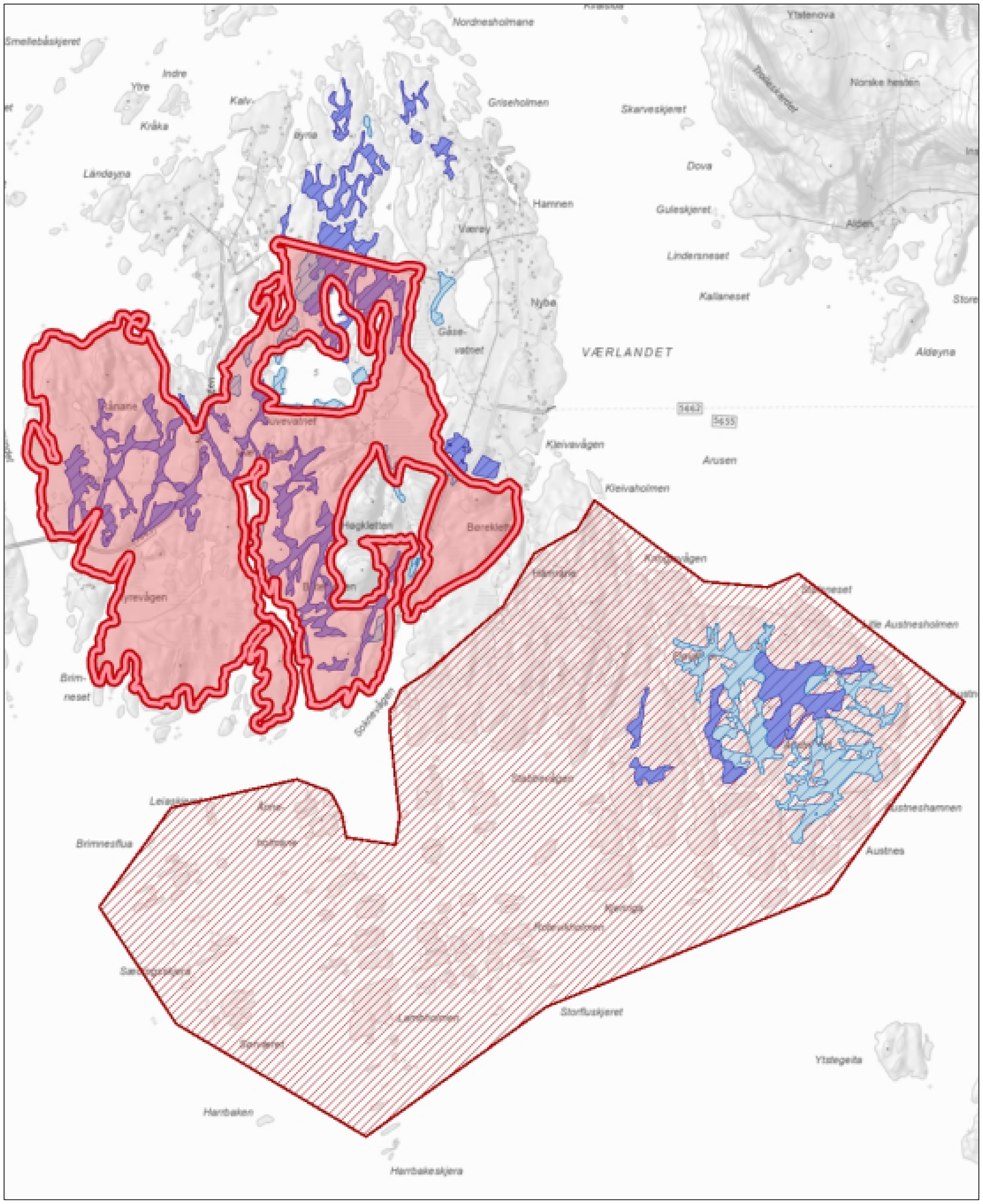
The map shows the registration of coastal heathlands at Værlandet as of 2019 (upper polygon with thick borders), wetlands and mires (scattered light and dark polygons) and Sørværet nature reserve (lower hatched polygon) (Naturbase, Norwegian Environment Agency, n.d.).
The guidelines for describing nature and for designating selected nature types are part of bureaucratic procedures and scientific practices of categorisation and mapping, which are steps taken to make the coastal heathlands legible and governable (cf. Scott, 1998). Governing through these political technologies implies a particular field of visibility of what is to be governed (Dean, 2010), and it exemplifies how such tools frame the boundaries of what is made relevant for governance (Asdal, 2004; Li, 2007b).
Mosaic of meanings
The challenges of categorising mosaic landscapes can be explored further by looking into the multiple meanings and presentations of Sørværet Nature Reserve in the western part of Værlandet. Sørværet Nature Reserve was established in 1991 to protect an important location for bird-hatching and nationally valuable mire habitats without being an obstacle to traditional grazing (Forskrift om Sørværet naturreservat, 1991). The County Governor's office has explained that its purpose is to safeguard a representative section of the coastal nature in authentic form. The office refers to the Nature Reserve as a reference site where nature “manages itself” as it did before humans appeared (Sogn og Fjordane County Governor, undated: 9, our translation).
However, Moen and Olsen (1983: 30), who assessed the mires at Værlandet a decade before the establishment of the Nature Reserve, acknowledged that there had been burning of the heathlands there in the past. Fremstad et al. (1991) noted that the biology of Sørværet Nature Reserve resembled the rest of Værlandet, and they suggested that the historical processes and practices shaping these landscapes were similar. Kvamme, one of the two scholars who conducted the national assessment on coastal heathlands, argued in a hearing note to the County Governor's draft management plan for the nature reserve that it is “[…] important to be aware that the natural qualities that are the basis for the protection […] have been created through the use of the area over a long period of time” (10.10.2011, our translation).
Also, from the local perspective, the Sørværet Nature Reserve represents a continuation of the coastal heathland landscape of Værlandet. Local residents recall when cows grazed the area and can point out the remanences of old housings for livestock. Thus, the idea of the Nature Reserve being a pristine area is disputed, and how to define and best manage this landscape is contested. More than 30 years after its establishment, the Nature Reserve has no final management plan. Meanwhile, the County Governor's office permits sheep grazing but is restrictive when it comes to heathland burning within the Nature Reserve. The authorities’ focus on mires and the lack of a management plan for Sørværet make it challenging for the sheep farmers to plan their use and get predictable access to the area. They must apply for any measure they want to carry out, which takes time and resources.
The County Governor's office has explained that it is awaiting new assessments of the mires to get a better understanding of their status and how they can be best conserved. This assessment was published in 2022, with the primary purpose of ascertaining whether the management regime of burning and grazing was harmful to the mires (Lyngstad et al., 2022). It found no indication that “burning has had an adverse effect on the peatlands”; on the contrary, it recommended that “heathland management with burning and grazing with the local breed of sheep should continue” (ibid.: 4). The assessment argued that in a mosaic landscape, like the Sørværet Nature Reserve, “it can be difficult to avoid some influence from burning on small mires and in mire margins [and the] practitioners should have considerable freedom to make practical decisions during burning.”
The example of Sørværet Nature Reserve shows that the mapping and categorising of nature, although important for bringing attention to the coastal heathlands over time, can also become an obstacle to a holistic view and management of these landscapes. Inventorying landscape elements without a deeper historical and social landscape analysis is at the risk of assessing what should be “a whole” only through its disassembled and recordable parts (Widgren, 1997). This further illustrates a governance system that has not heeded its ideals of mobilising local perspectives and traditional knowledge in restoring and managing cultural landscapes. Also, it shows how discourses about what the landscape is, how it should be understood and how it ought to be managed are powerful and not easily swayed once values are established.
Mosaic of politics
Other factors that affect the possibility for holistic management of the coastal heathlands are the fragmented responsibilities and conflicting policy objectives between authorities. The environmental authorities are responsible for mapping and registering semi-natural habitats, while, to a large degree, the agricultural authorities govern economic incentives for the practical management and conservation of these habitats (Norderhaug and Svalheim, 2009; Østebrøt and Betten, 2009). Thus, despite the knowledge generation on the importance of cultural landscapes and their fragile state, from the 1990s and onwards, the national attention to protecting the landscapes of semi-natural habitats has remained dispersed and unfocused. One notable exception is the Agricultural Landscapes of Special Interest locations, where the authorities collaborate across sectors to make the leap from mapping and documentation to binding and long-term management and maintenance (DN et al., 2008). This is, however, limited in scope to 51 carefully selected locations nationally.
Part of the economic incentives for maintaining selected habitat types, such as coastal heathlands, are directed through the environmental authorities and, as discussed above, conditioned on the location being registered in Naturbase. However, the agricultural authorities’ economic incentives are related to production. A criterion for being entitled to a grant is that the applicants “carry out normal agricultural production” (NAA, 2023). In 2019, many farmers of the Old Norse Sheep breed received a letter from the agricultural authorities that their production could not be recognised as ordinary agricultural production, and therefore, they would lose parts or all the production grants. The leader of the Norwegian Old Norse Sheep Association argued that this could jeopardise a whole strain of sustainable and traditions-based farming practices (Buer, 2019). She explained that the modern breed of Norwegian sheep eats constantly to maximise production, requiring extra input factors (such as hay) to maintain production and animal welfare throughout the year. The Old Norse Sheep, in contrast, is a smaller breed (a living animal weighs approximately 35 kg compared to modern sheep that weighs 90 kg). It requires little supplementary animal feed and is not equally dependent on infrastructure, such as heated buildings. The Old Norse Sheep, she argued, is an exceptionally functional sheep that produces optimally from poor grazing resources (Buer, 2019). While the suggested cut in production grants was not implemented, it sent a strong signal to these farmers that their production is not favoured.
There is some financial support for outfield grazing and maintaining cultural landscapes, but these grants are small compared to the production subsidies tied to meat production. Hence, farming practices that best preserve the coastal heathlands – extensive practices and using old sheep breeds best suited to the grazing resources, to the climate, and to the landscape – do not produce the meat volumes that maximise the production subsidies. Moreover, the Old Norse Sheep breed is regarded as too small and unsuited for the machines and routines in the slaughterhouses adapted to the modern breeds. Slaughtering the former means more work per kilogram of meat sold to the grocery stores, and consequently, the slaughterhouses pay very little per Old Norse Sheep (Interview 1D, 14.02.2020). Thus, while maintaining coastal heathlands requires functional animal breeds (such as the Old Norse Sheep), the market economy and state-funded economic incentive system promote productive breeds (such as the modern breeds). While the stewardship of coastal heathlands requires voluntary commitment from land users, it is challenging to make a living from the extensive agricultural practices. A consequence of a lack of economic support for the extensive practices is that many farmers of Old Norse sheep along the coast adapt by crossbreeding their sheep with modern breeds to increase their weight, and hence increase their earnings at slaughter (Interview 4a, 11.11.2023). In this way, the animals become more accustomed to supplementary feed, which again can lead to less use of the heathlands for grazing, which can also disrupt the nutrient balance in the coastal heathlands.
The national policies for biodiversity (Meld. St. 14, 2015–2016), agriculture (Meld. St. 11, 2016–2017) and cultural environments (Meld. St. 16, 2019–2020) define shrubification as a threat to cultural landscapes. They point to land use change as a primary cause and recognise the need for active stewardship (mowing and grazing) to conserve these landscapes. The White Papers also acknowledge the conflicting policy goals between and within the sectors but do not provide solutions to the conflict. The White Paper on agriculture explains that the structural changes in Norwegian agriculture have “led to increased shrubification in previously open agricultural landscapes, with mowing and grazing being greatly reduced or absent” (Meld. St. 11, 2016–2017: 126, our translation). The White Paper on biodiversity notes that “it is neither possible nor desirable to revert to the agricultural techniques that were common fifty years ago. Nevertheless, action to maintain the ecological status of areas of the cultural landscape is important” (Meld. St. 14, 2015–2016: 37).
The action plan for the coastal heathlands (DN, 2013) emphasised various soft measures for preserving the heathlands: building capacity for heathland conservation, encouraging voluntary local management plans with relevant farmers and land users, and providing economic compensation for those who engage in the upkeep of the coastal heathlands. The focus on volunteering was underscored when the coastal heathlands were given status as ‘selected habitat type’ in 2015, and the Minister of Climate and Environment presented the arrangement as “a mild tool with a lot of local autonomy” that would “stimulate cooperation and sustainable use” (MCE, 2015: our translation). However, the landscape stewardship that the conservation of coastal heathland is premised on cannot be taken for granted.
Concluding remarks
The political technologies used to define and make sense of nature form the coastal heathlands as an object of governance. In this paper, we have shown how the tools and the knowledge technologies that authorities and experts employ to display the value of and the necessity of conserving the coastal heathlands may also act as obstacles to the holistic conservation of the very same landscapes.
These technologies, visible as methods for mapping and categorising nature, are based on standardised, verifiable, and universal variables to avoid valuation and discretionary interpretation by the assessor. As such, they entail a subjectification of landscape to ecological considerations and technologies designed for biodiversity conservation (Waage and Benediktsson, 2010). Although coastal heathlands are often framed with reference to the elusive concept of cultural landscapes, such a framing is not necessarily helpful in agreeing on what values are to be maintained. A scientific and administrative propensity to categorise nature and render the coastal heathlands technical through mapping and cataloguing (Li, 2007b), masks the mosaic of habitats that make up the landscapes, as well as the local meanings and values that these habitats entail. Our case study shows that whether one reads and understands the landscape through categories of distinct habitats or as a mosaic has implications for its management and caretaking.
The local farmers and residents of the archipelago have their own ideas of what coastal heathlands are and where they are located. These alternative makings of the landscape are more closely linked to a story of local land use practices. In contrast, a governance system that rests on mapping and monitoring the parts of the whole (Asdal, 2008b) – through selected habitat types – implies a particular field of visibility of what is to be governed. By following the map and not the terrain – or rather, what is mapped – the consequence is losing out on historical and local context in managing these landscapes. In this process, the temporality of the landscape (cf. Ingold, 2000), is erased.
Despite competing understandings as to where the heathlands are found and how they ought to be understood, there is however a shared belief locally, regionally, and nationally that the coastal heathlands are best conserved by preventing shrubification and maintaining an open landscape through grazing and burning. A further prescription from the environmental and agricultural authorities is that this can best happen through voluntary efforts by the local land managers and farmers. Through a range of political technologies – laws, regulations, policies, measures, incentives, and awareness raising – local land managers and farmers are stimulated or ‘disciplined’ (Foucault, 2008) to become agents of landscape stewardship. Governmentality, in this way, creates new subject positions and new subjectivities that act as vehicles of identity and community formation (Foster, 2018).
Still, the policies of nature conservation and agriculture are not attuned to what can be seen as a shared goal of conserving the coastal heathlands. They offer competing incentive systems, with economic support skewed toward intensive land use and food production. This undermines the mobilisation of voluntary efforts by landowners and farmers – efforts that are essential for the upkeep of semi-natural habitats and the multiple values they embody. Currently, conservation appears to largely rely on the idealism of farmers and landowners, whose personal values and alternative makings of the landscapes motivate them (beyond purely economic considerations) to do as they ought in the stewardship of semi-natural habitats.
Our case study reveals structural tensions in the governance of semi-natural habitats, where fragmented mandates and narrowly framed policy instruments risk compromising conservation goals. These tensions can be understood through the lens of governmentality, where power is exercised not only through formal policies but also through the shaping of practices and subjectivities (Foucault, 1991). The findings suggest that conservation policies often work by influencing the behaviours and decision-making of local actors through incentive structures that encourage productivity-driven land use. In this context, the prioritisation of intensive agriculture marginalises the extensive, low-intensity practices upon which the persistence of cultural landscapes depends. This reflects a neoliberal logic of governance that emphasises efficiency and market-driven outcomes, often at the expense of social and ecological values (Bakker, 2010; Rose, 1999).
We argue that the governance of coastal heathlands – and similar landscapes – requires an integrative approach that acknowledges their multifunctionality. This includes not only their ecological significance but also their cultural and social dimensions, challenging the separation of nature conservation from cultural heritage (Jones and Daugstad, 1997). The incentive structures should be reconfigured to support long-term stewardship and alternative land use rationalities, which can account for the diverse roles of local land users in maintaining these landscapes. Drawing from the governmentality literature, we emphasise the importance of recognising the agency of local actors, where power is exercised not as external control but through forms of self-regulation and participatory governance (Larner and Walters, 2004). Our findings call for a shift from rigid, expert-driven governance models toward more flexible and participatory approaches that embrace diverse ways of knowing, valuing, and managing landscapes.
Highlights
This paper examines how coastal heathlands are shaped into governable objects and explores how national conservation policies align with local landscape practices.
The scientific and administrative propensity to categorise nature can obscure the mosaic of habitats, meanings, and values embedded in the landscapes.
Governance based on mapping and monitoring tends to focus on isolated parts of the landscape, overlooking value conflicts and historical and local perspectives.
Through various political technologies, local farmers and landowners are encouraged to take on roles as landscape stewards, though competing policy incentives complicate their engagement.
Despite broad agreement across sectors on the importance of maintaining coastal heathlands, local farmers and landowners undertake conservation efforts independently rather than in response to policies and regulations.
The tools and knowledge systems used by authorities to define and justify conservation needs may be an obstacle to more integrated approaches to conservation.
Footnotes
Acknowledgements
This research is carried out as part of the FOODCOAST project financed by the Research Council of Norway (#295004), investigating cultural heritage dimensions of food and the relationships between the food producers, their resources, and the ecosystems they depend on. We want to thank our informants for taking part and sharing their knowledge. We also extend our gratitude to the two anonymous reviewers.
Author contributions
All authors have taken part in data collection, analysis and writing.
Ethical considerations
Informed consent procedures were approved by the Norwegian Agency for Shared Services in Education and Research (Sikt), 27.01.2020 (#841180)
Consent to participate
Respondents gave written consent before starting interviews.
Consent for publication
Not applicable
Data availability statement
Not applicable
Declaration of conflicting interests
The author(s) declared no potential conflicts of interest with respect to the research, authorship, and/or publication of this article.
Funding
The authors disclosed receipt of the following financial support for the research, authorship, and/or publication of this article: This research is part of the FOODCOAST project financed by the Research Council of Norway (#295004).