
Abstract
In 2016, South Africa launched its National Biodiversity Economy Strategy. This strategy aims to facilitate the development of a ‘wildlife economy’ as a solution to unemployment, loss of biodiversity and rural development. Central to the strategy is the role of private conservation actors, who keenly posit their commercial model as the best way to achieve these objectives. This stands in sharp contrast to recent critiques that suggest that private conservation reinforces structural inequality by denying access to land and perpetuating unjust labour conditions. Using ethnographic data from the South African Lowveld region that includes the Kruger National Park, the paper takes these points further by arguing that a rapidly growing alliance between private conservation and property developers actively conserve inequality by maintaining and even extending spatial injustice in the region. Two popular recent manifestations of this alliance in particular, share block systems that distribute ownership of access to real estate in private reserves and wildlife housing estates, have established new conservation-property linkages that entrench capitalist socioecological fixes. Not only do these initiatives lead to further engrained spatial injustice, we conclude that this conservation-property alliance at the centre of the ‘wildlife economy’ also willingly sacrifices environmental sustainability on the altar of white conservation imaginations and private profit.
Introduction
South Africa has long been a prime global wildlife destination. Home to the most iconic wildlife species in sizable numbers and enabled by a thriving, modern tourism industry and infrastructure, the country is keen to further develop a ‘wildlife economy’ that brings in (foreign) investment, revenue, jobs and development. Arguably at the centre of much of this dynamism is a town called Hoedspruit, situated 63 km west of Kruger National Park (Figure 1). This self-titled ‘wildlife haven’ is located in the savannah bush of the Lowveld region and boasts the highest concentration of private nature reserves in South Africa. The town is surrounded by 172,000 ha of private nature reserves that promise Big Five sightings, bush walks, game drives and luxury accommodation with splendid views of the Olifants River and the Little Drakensberg mountain range. In addition, the town is surrounded by residential wildlife estates, a type of gated community with preserved bushveld and wildlife. While there is significant commercial mango and citrus farming in the region, it is the wildlife economy and proximity to Kruger National Park that brings tourists and investors to Hoedspruit.
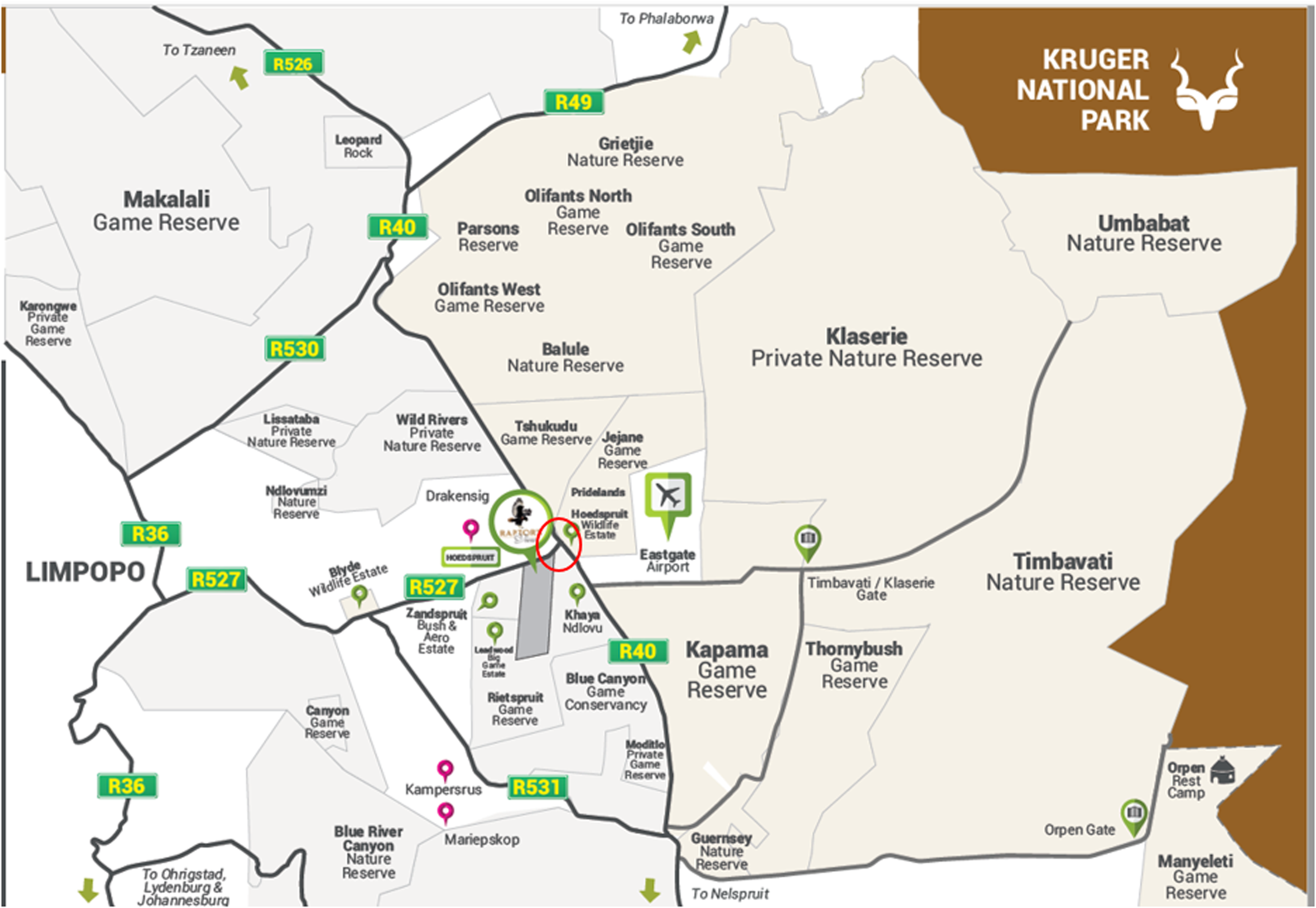
Map of Hoedspruit (red), surrounding estates and nature reserves (sourced from Raptors view wildlife Estate website, 2020). 36
This idyllic description of Hoedspruit and surrounding nature reserves – often found in promotional materials – masks the fact that the town, nature reserves and nearby ex-Bantustans have long been and continue to be entangled in property, labour and social tensions. These have deep historical and apartheid origins (Davis, 2014) that have left a scarred, highly unjust geography under the thin mythical veneer and promise of the wildlife economy. Spatial injustices that combine forced removal, structural racism, labour and other forms of discrimination and landlessness have never been properly addressed in this region yet are now rendered even more intractable due to the massive property and infrastructural investments resulting from the wildlife economy. The qualitative changes brought by these dynamics, as well as their effects, require urgent analysis. This is because the wildlife economy's façade, a booming luxury ecotourism industry fit with shopping and conference centres, airstrips, private security and telecommunications, has over the last years seen a much less familiar intensification of the alliance between private conservation and property developers. The effects of this alliance, we will show, are not merely the maintaining but a significant deepening of the region's spatial injustice.
While relations between private conservation and property developers go back a long way, their interests have more recently converged in several new conservation-property linkages like wildlife estates and ‘share blocks’ in private reserves. A share block is an ‘alternative form of property ownership for people wanting holiday homes on a game reserve in Hoedspruit. This allows property owners access to large traversing areas and share resources with regard to managing the property. The property owners still have exclusive usage of their houses but it's the land and game drive areas that they share’. 1 Basically, it is about buying shares in a company that owns land in a private nature reserve and in return receiving exclusive access and enjoyment rights to a property on the reserve. A wildlife estate is a type of residential estate where wildlife roams free and where housing developments are combined with undeveloped wilderness areas for game viewing, walks and birding. Currently, six such estates have sprung up in and around Hoedspruit. While bringing significant investment and development dynamics, the implications of these large-scale infrastructural developments and property innovations in conservation spaces are yet to be explored.
The paper argues that private developer-driven conservation urbanization has been invented and promoted in and around Hoedspruit with the explicit understanding that it would conserve inequality by maintaining and deepening racialised spatial injustice. 2 While we are not saying that growing inequality has been an objective of private developer-driven conservation, we do argue that their desire to enhance their wealth while playing into white imaginations of identity, security and love for wildlife would, in the South African context, always lead to entrenching, even exacerbating, inequality. Private conservationists and property developers are fully aware of this and, as we will show, deliberately strive to ward off attempts to redress spatial injustices. Furthermore, we argue that under the thin veneer of wilderness is a resource-intensive lifestyle that promotes unsustainable consumption.
To understand how this situation has come about, we investigate the implications of private developer-driven conservation spaces such as wildlife estates and share blocks in nature reserves as capitalist socioecological fixes. This idea is meant to ‘capture the ways in which the social relations and material and symbolic conditions of capitalist accumulation are reproduced through investments in landscapes that are simultaneously and always conjoined productions of space and nature’ (Ekers and Prudham, 2017: 1,371). The fix element here is important, as combined forms of white capital and white conservation imaginations get sunk into the land to reproduce complex and overlapping judicial, ownership and property infrastructures. The complexity and ‘share’ co-dependence of different actors ensures a fixity that creates spatial forms that become (further) entrenched, in that they become (even) more difficult to transform.
We believe these recent dynamics are critical in understanding ‘the underlying power relations that displace people and that re-entrench severe social inequalities unfolding in the context, and in the name of biodiversity conservation’ (Mollett and Kepe, 2018: 1). They are equally critical in understanding ‘how spatial relations participate in justice claims’ (Williams, 2018: 6). To connect these two elements – spatial justice and capitalist power relations – we begin the paper by first building on theorizations of capitalist socioecological fixes and extending these to include spatial justice. This is followed by a history of the development of Hoedspruit to expose the origins of spatial injustice in the region. Next, we focus on how private conservationists and property developers have innovated on older mechanisms through wildlife estates and share blocks to maintain and reinforce white control over land, animals and labour and, in a very concrete way, ‘fix’ spatial inequalities into the social-ecological landscape. We end by discussing these dynamics within the context of Hoedspruit's overall development to conclude that conserving inequality is not the only perverse effect of the new attempts to combine private conservation and property development: this type of conservation urbanization at the centre of the ‘wildlife economy’ also willingly sacrifices environmental sustainability on the altars of white conservation imaginations, consumption culture and private profit.
Socioecological conservation fixes and spatial (in)justice
To understand how conservation-property linkages ‘fix’ spatial inequalities into social-ecological landscapes, we need to start with a basic tension in Marx's concept of fixed capital, namely that between mobile-immobile or stability-change. According to Harvey (2001: 27) ‘the category of fixed capital in Marxian theory refers to capital that is embedded in some asset or thing (such as machinery) which is not directly or even indirectly consumed in production (as are raw materials or energy inputs) but which gets used up (and worn out) over several production cycles’. These are machines, infrastructures and the like that allow for the circulation of value yet stay within the sphere of production and as such only indirectly produce surplus-value. But there is, of course, a double meaning of ‘fixed’ here, as Harvey (2001: 27) emphasizes: Note that the term “fixed” in this case refers to the way capital is locked up and committed to a particular physical form for a certain time-period. But a distinction must be drawn between fixed capital that is mobile and that which is not. Some fixed capital is embedded in the land (primarily in the form of the built environment or more broadly as ‘second nature’) and therefore fixed in place. This capital is “fixed” in a double sense (tied up in a particular object like a machine and pinned down in place).
Harvey refers to the example of an aeroplane as a form of fixed capital that is highly mobile, but that needs immobile forms of fixed capital (airports) to function. Hence, there is a more central tension here noted by Harvey, namely that for capital to move across space and circulate, it needs fixed capital that is highly immobile, which is precisely why urbanization is so important in the broader geography of global capitalism. But since the ultimate point about fixed capital is its particular use in the production process and not (merely) the tension between mobile and immobile, there is another tension that requires emphasis, namely that ‘production and consumption are increasingly imprisoned within fixed ways of doing things and increasingly committed to specific lines of production’ (Harvey, 2006: 220–221). It is both these connotations to ‘fixed’ that matter in this paper: immobilized into space and ‘fixed ways of doing things’. These are also central to Harvey's understanding of ‘spatial fixes’: ways in which spaces get used in order to allow capital to move across space and seek geographical ways out of its contradictions, most especially that of overaccumulation.
In turn, we need to highlight how these fixes relate to broader ideas of shaping landscapes and nature. Here we build on Ekers and Prudham (2017), who take Harvey's concept of the spatial fix further by considering its social and ecological implications. They consider the spatial fix as a metabolic process, such that investment in landscapes following the crisis of over-accumulation should be seen ‘as an important site where the production of space and the production of nature happen together as differentiated but co-constituted unities’ (2017: 2). In their conceptualization of the socioecological fix, they put Harvey's spatial fix in conversation with Smith’s (2008) production of nature to ‘capture the ways in which the social relations and material and symbolic conditions of capitalist accumulation are reproduced through investments in landscapes that are simultaneously and always conjoined productions of space and nature’ (Ekers and Prudham, 2017: 2).
This work further demonstrates that socioecological fixes are often initiated to counter or alleviate environmental degradation, biodiversity loss or fossil fuel consumption (amongst others), but in reality exacerbate pre-existing inequalities, power asymmetries and unsustainable practices (Clay, 2019). In this way, a third connotation to ‘fix’ important in the paper emerges, namely that of ‘fixing a problem’ or, more specifically, a ‘quick-fix’ that seems to respond to a problem but does not actually engage its root causes. The socioecological fixes we consider in this paper, wildlife estates 3 and share blocks, are a case in point: they are often posited as solutions to curb environmental degradation by preserving biodiversity. Yet, as we will show, they do so by emphasizing certain (imagined) historic-spatial moments – in this case people-free, abundant wilderness – while ignoring, and thereby ‘naturalizing’, other historic-spatial processes – in this case those that transformed spatial arrangements into sites for capital accumulation. The result, we show, is spatial injustice. According to Dikeç, spatial injustice should be seen as ‘the idea that the very production of space, which is inherently a conflictual process, not only manifests various forms of injustice but actually produces and reproduces them (thereby maintaining established social relations of domination and oppression)’ (2001: 1,788). In the case of conservation, this means building on a long historical pattern of spatial injustice, which have manifested in evictions (Brooks, 2005; Hitchcock et al., 2011; Lunstrum and Ybarra, 2018), increasing antagonisms between nation-states (Trogisch and Fletcher, 2020), undermining land restitution (Ramutsindela, 2015; Ramutsindela and Shabangu, 2018) and the displacement of environmental concerns from one site to another (Deutsch, 2018), amongst others. In the ‘quick-fix’ marketing of conservation and its benefits for biodiversity, these issues are often ignored or downplayed.
This paper contributes to this body of work by critically exploring the production of space and nature in exclusive, capital-intensive wildlife estates and share blocks in the Lowveld region of South Africa. We privilege the role of private property developers whose decisions about where and when to fix capital has significant implications. In the literature, this has been shown for the built environment in cities (Charney, 2003a, 2003b), tourism destinations (Yrigoy, 2014) but less so for conservation landscapes. The role of property developers in co-creating conservation landscapes has thus far been under-appreciated because other actors like Non-Governmental Organization (NGOs) (Brockington and Scholfield, 2010; Chapin, 2004), philanthropists (Holmes, 2015; Koot and Fletcher, 2019) and development banks (Büscher, 2013; Milgroom and Spierenburg, 2008) have often been at the forefront of channelling investment into conservation landscapes. However, as the following sections will show, when South African, Dutch, Belgian and Danish private property developers invest in new types of conservation landscapes they reproduce racialised spatial injustices which ultimately conserve inequality. In these discussions, the three connotations of ‘fix’ highlighted in this section will be illustrated empirically.
Historicizing spatial injustice in Hoedspruit
“Hoedspruit is today the center of an intensive farming area and comprises approximately 85 farms within a 10-mile radius. The main products of the area are rice, tomatoes, vegetables, citrus and fruits” (BP Southern Africa, 1962)60
In 1961, BP Southern Africa injected a fixed capital investment of 44,000 ZAR (South African Rand) to establish a petroleum and paraffin depot on a portion of Berlin farm in Hoedspruit. Foreseeing future demand as a result of mining in Phalaborwa and the growth of commercial farming activities along the Blyde River (west of Hoedspruit), BP leased land in Hoedspruit to operate a depot that would supply petroleum products to the region. In addition to BP, Caltex and Shell operated on the same premises and together sold approximately 100,000 gallons of petroleum per month. Over 55 years later, Hoedspruit and its environment are still a centre of intensive farming and mining. But in terms of what draws attention to the area, the wildlife and nature-based tourism economies have decidedly taken over. To understand spatial injustice in the region, it is critical to recognize this transition and how the farming and wildlife sectors have co-evolved.
The establishment of the depot came years after hundreds of Mapulana families had been evicted from surrounding farms to nearby Bantustans: areas legally set aside for exclusive black occupation during apartheid. Hoedspruit and surrounding farms were located outside of Bantustans so black people could not own land legally or reside there permanently. While many were evicted to create space for aspirant white farmers, a few Mapulana were retained on the white-owned farms as labour tenants. Under the labour tenancy arrangement, black people had to render three months of labour for free and in return could live on the farm and keep a few livestock. However, due to mechanization and capital growth, some farmers in the Hoedspruit area replaced labour tenancy with waged labour (Ritchken, 1995). The BP depot thus came at an opportune moment because apart from some labourers and their families, the land had been purged of black people and their livestock, thus creating space for white agriculture. Moreover, state subsidies (Arrighi et al., 2010), cheap labour (Mather, 1995), and water from the Blyde River made farming a lucrative endeavour, holding many promises for white farmers. Less than a year after operating, BP was already looking to expand the depot indicating the growing need for petroleum and paraffin in the region. 4
As a result of these developments, Hoedspruit and surrounding farms became highly profitable while evictions created overcrowding in the Bantustans (Niehaus et al., 2001). In 1970, the Transvaal Board for the Development of Peri-Urban Areas prescribed the Hoedspruit area under the Bantu (Urban Areas) Consolidation Act No. 25 1945 and the Bantu Labour Act No. 67 1964. 5 The Bantu Consolidation Act along with amended policies 6 introduced ‘influx control’ in urban areas to control the number of black people in cities. Unless born in the urban area or a permanent resident, black people could only live in the proclaimed area as labourers upon being issued a permit. The Black/Bantu Labour Act, at the same time, stipulated that Africans would only be employed in the city through the state labour bureau.
Both policies, read within the broader context of the segregationist policies of the apartheid regime meant that only white people belonged as full citizens in Hoedspruit. Black people's movement was severely monitored and their residence was subject to their employment conditions. That is, only when performing labour could a black body occupy space in Hoedspruit and surrounding white-owned farms. In a very real sense, then, these developments ‘fixed’ both the spatial base for the growth of capital and social relations in support of the same. These restrictions on movement and residency were compounded by evictions from present-day Hoedspruit (Davis, 2014).
From the 1960s, the above indicated transformation started when some whites residing closer to the Kruger National Park abandoned livestock farming in favour of wildlife ranching. In present-day Kapama private nature reserve, bonsamara cattle were abandoned in favour of game farming due to harsh environmental conditions and presence of predators. 7 Similarly, on Klaserie private nature reserve, ‘after 1930, cattle ranching was attempted but problems with pests, predation and marketing led to most of the area coming under conservation management during the 1970s’ (Walker et al., 1987: 385). In the Timbavati reserve, it is stated that land-use changes were prompted by a realization that some activities could lead to habitat degradation. 8 Today, it is widely accepted that livestock farming along with hunting decimated wildlife populations and degraded the land (Carruthers, 2008; Kreuter et al., 2010).
While wildlife reserves cite an appreciation of nature as a catalyst for land-use changes, farm conversions have also been attributed to ‘legislative change that allowed private landowners to utilize and manage wildlife on their land without government permits’ (Kreuter et al., 2010: 510). During apartheid, this essentially meant that only whites could utilize and keep wildlife legally. This is reflected in various policies including the Game Ordinance No. 23 of 1949 that prohibited the issuing of hunting permits in areas designated for blacks. Similarly, the Vermin Destruction Ordinance No. 25 of 1949 made clear that only ‘Europeans’ may create a ‘vermin hunting club’. While we cannot ascertain the rate at which these policies were enforced, there are records in the archive of blacks convicted of poaching. Commenting on game protectionism in the Transvaal in the early 1900s, Carruthers (1988: 52) notes that ‘game legislation seems to have provided increased control over rural labour and assisted in its proletarianization’. Essentially, whites could legally monetize game whereas blacks were barred from even hunting problem animals, which, as Carruthers notes, contributed to their dependence on waged labour.
In addition to game legislation, international sanctions against the apartheid regime and the withdrawal of state subsidies made livestock farming less lucrative for white commercial farmers (Carruthers, 2008). All these conditions, coupled with the growing tourism industry made wildlife farming all the more attractive (Dlamini, 2020). The first farm conversions in this area began in the late 1950s with the declaration of a private reserve which was later incorporated into Kapama private game reserve. In the 1960s alone, over ten private nature reserves were gazetted in the area; the size of the reserves ranged from 1,300 ha to 52,000 ha. The farm conversions were followed by the erection of fences, (re)introduction of wildlife and the construction of lodges to cater for the growing tourism industry.
Through all these changes and although Hoedspruit continued to be the centre of livestock, cash crop and wildlife ranching, it remained nothing more than a dorpie (small town). Ultimately, capital investment in the small town, irrigation farms and later private nature reserves was enabled by the apartheid state which resulted in the uneven geography of this region. From this account, it is clear that conservation was not just a beneficiary of a racialized property and labour regime; the emerging wildlife economy of the 1960s was contingent on black people being absent from farms yet available for labour, all within a geography rendered suitable for capital accumulation. At the same time, the production of nature within these private spaces necessitated investment in tourism development, property infrastructures such as lodges and bush camps and, importantly, infrastructures outside of reserves that facilitate tourists’ mobility and enjoyment of nature. The socioecological processes that produced the Lowveld landscape and nature have ‘fixed’ the farm as a site of production, one which is steeped, as the next section shows, in white conservation and property imaginations about pristine wilderness.
‘Fixing’ biodiversity (loss) to ‘fix’ spatial injustices
The co-constitutive relationship between fixed capital and the production of nature is readily apparent in share blocks and wildlife estates, which can be regarded as socioecological fixes par excellence. These private developer and conservation driven developments are part of a suite of initiatives meant to fix biodiversity loss and habitat degradation by investing in large scale residential and tourist developments while simultaneously preserving ‘wilderness’ areas. We begin with wildlife estates.
Hoedspruit is surrounded by six wildlife estates (∼7,300 ha): residential estates where wildlife such as ungulates and sometimes – in Big Five estates – more dangerous animals including predators roam free (Figure 1). Typically, a wildlife estate has undeveloped wilderness areas where residents can enjoy game drives, bush walks and bird watching (Table 1). The first wildlife estate, Raptors View, was pioneered by a prominent South African property developer in 2000. Shortly after that, more estates were built in the area by Dutch, Belgian, Danish and South African developers. Wildlife estates operate in similar manner to ‘regular’ estates, including security-controlled access, architectural guidelines, levies and homeowners’ associations. What sets them apart is the wildlife management considerations, such as veterinary services, monitoring vegetation and stock numbers, and translocation of wildlife to maintain a viable gene pool on the enclosed properties.
Wildlife estates in and around Hoedspruit.
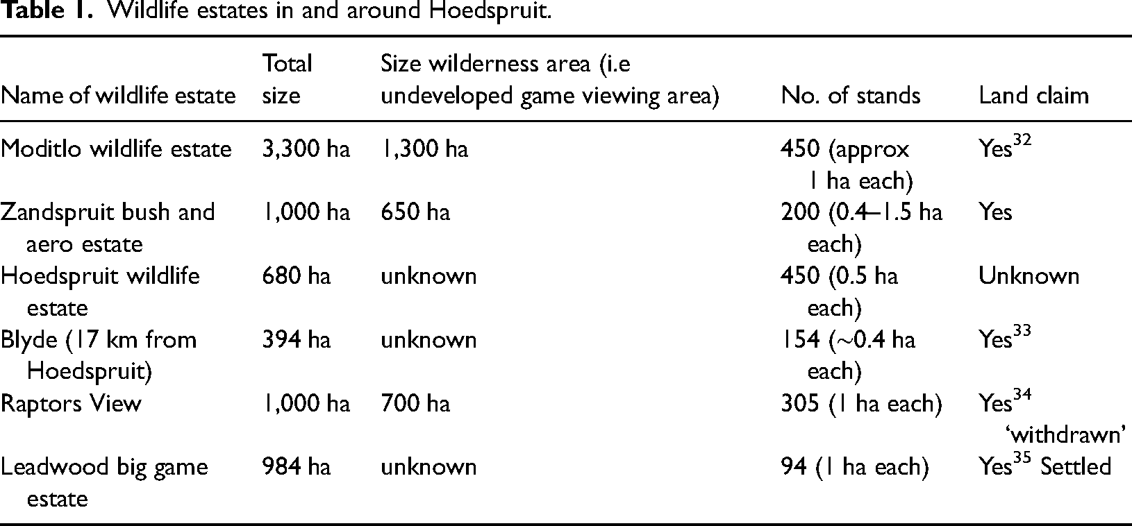
The estates range from high end to ‘affordable’. They offer a range of services and amenities including schools and due to rapid further development of Hoedspruit town are now near shopping centres, a gym and restaurants. Whether they have tarred roads or not, all wildlife estates promote low-density living while some even have tourist lodges. For example, of the 1,000 ha in the Dutch developed Zandspruit aero estate, 650 ha is an undeveloped wilderness area. Due to low-density living and the presence of wildlife, property developers argue that wildlife estates maintain ecological integrity and promote conservation goals. This is captured by the Raptors View website, which states that the estate ‘has a strong focus on conservation. The wildlife and vegetation need to be monitored and decisions made to ensure that this fragile system remains sustainable’. 9
The ‘fragile system’ in question also includes a network of fibre optic cables, sewage infrastructures such as wastewater disposal pipes and a sewage treatment plant. In addition, built into every estate are roads, fresh water pipes, stormwater drainages and electricity cables and transformers. Some estates also have artificial dams and wetlands, watering holes, boreholes reservoirs and tanks. Furthermore, some, including Hoedspruit wildlife estate, used to be cattle farms but are now ‘stocked with a large variety of plains game’. 10 To transform the degraded veld into serviced residential plots necessitated investment in fixed capital, landscape architects to design the layout, wildlife to stock the estates and, of course, fences to facilitate ‘security’. Consequently, when the Hoedspruit wildlife estate architectural guidelines refer to ‘the natural environment’ or ‘natural habitat of the game’ (HWE HOA, 2020: 3) 11 it negates the ‘past exertions of living labour’ (Ekers and Prudham, 2018: 23) and the labour that maintains the modern infrastructure necessary for tourists and residents. Furthermore, claims about the ‘natural environment’ disavow the historical presence of Mapulana families who were evicted from these farms during the apartheid era. Through democratic South Africa's land restitution programme, Mapulana have since submitted land claims application for most of the farms in wildlife estates (Table 1).
As the previous section showed, the transformation of the Lowveld landscape has been ongoing for a long time. However, what is new about wildlife estates is the seemingly seamless convergence of private developers and conservation interests. Furthermore, what sets this development apart from previous ones is the influx of permanent residents and tourists as a result of amenities and infrastructure such as schools, airports, shopping complexes and lodges which have made living in and visiting ‘the bush’ possible for families with children as well. To be clear, we are not suggesting that the development of Hoedspruit town was caused solely by wildlife estates, but one cannot ignore the material changes that would inevitably follow the servicing of 1164 residential stands (of which some are still vacant) within estates. Capital sinking to produce space and fix nature in wildlife estates transformed the dorpie with one petrol station into a town with five shopping complexes, two petrol stations, many restaurants, a car rental company and at least three banks.
Not only did the development of residential estates transform the town, but it also reproduced and often even reinforced the apartheid social relations discussed in the previous section. To make this point we zoom into the Dutch-South African developed, Zandspruit bush and aero estate which boasts a 1 km runway for light aircraft. According to a public official, a deal to purchase land in what is now Zandspruit fell through when someone outbid the municipality upon learning about plans to develop low-cost housing. 12 This was implicitly corroborated by a Zandspruit employee who noted that it was ‘very fortunate’ that the South African developer purchased the land because low-cost housing ‘would have killed the town’, due to a massive influx of poor people, which according to him would have been a ‘mess with too many houses, and chaos’. 13 Given South Africa's racialised inequality, poor people in this case essentially means black people. A few other developers, estate agents and residents have echoed a similar sentiment about the undesirability of low-cost housing (Koot et al., n.d.). But some, as the public official noted, have taken it a step further by actively sabotaging any efforts to undo the spatial inequality of Hoedspruit and surrounding areas.
In addition to Zandspruit, another revealing case pertains to Hoedspruit wildlife estate (HWE), the most ‘affordable’ and most ‘densely’ populated estate in the area. The estate was developed by Hannes Wessels of Boschpoort Ondernemings (Pty), 14 a since liquidated South African property developer. In 2020, a 2-bedroom house on a 0.5 ha stand would cost 2.8 million ZAR on average. This demonstrates that only well-to-do persons could buy into the most affordable estate. Unsurprisingly, most of the HWE residents are white middle to upper-class families who enjoy access control and 24-h security in the bushveld. The picturesque estate borders portion 7 of the farm Welverdiend 243KT, home to the Bangu and Mokoena families. As mentioned, during apartheid, some families were evicted to Bantustans in Bushbuckridge while others were retained as farm labourers and labour tenants on commercial white-owned farms. Of the families that were retained, the Bangu and Mokoena have been the most persistent. Their story reveals how property developers and conservation imperatives reproduce spatial injustices.
In 2007, Welverdiend 243KT was sold to Boschpoort Ondernemings (Pty) Ltd of Hannes Wessels, the developer of HWE. 15 Shortly after that, the Bangu and Mokoena received an eviction notice because ‘Wessels wanted to build lodges’. 16 The families opposed the eviction in court. 17 Meanwhile, as the court proceedings ensued, buffalos were introduced, thus making life untenable and unsafe for them. Finally, in July 2007 the court ordered that the families could be evicted and the structures (Figure 2) that Boschpoort built were sufficient. In the court proceeding, Boschpoort argued that the Bangu and Mokoena were moved to protect them from buffalo. Conversely, the initial environmental management plan of HWE stated that buffalos ‘impacted on the carefree movements of residents and their children. The buffalo however were soon relocated to the benefit of the safety of the residents’. 18 The Bangu and Mokoena were not afforded the same courtesy. Rather, in the process of creating space for wildlife and residents of HWE, their property was destroyed, their lives were put in danger and their dignity was trampled on.
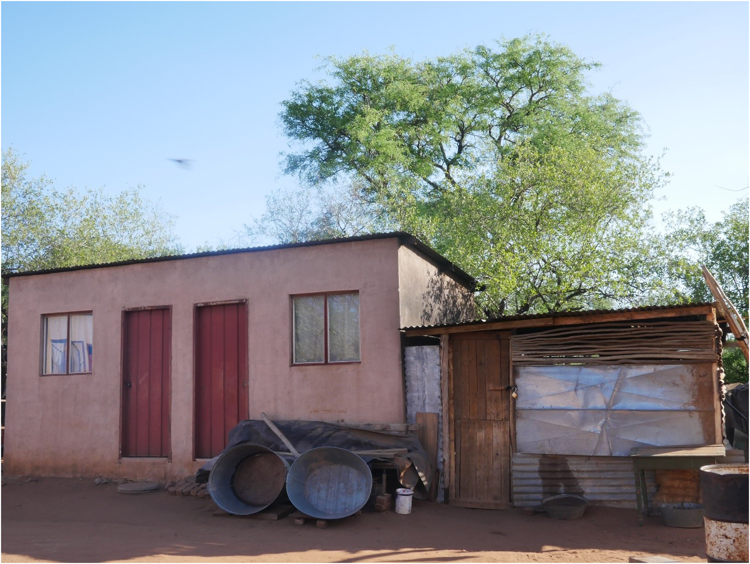
One of the four structures that were originally built by Boschpoort Ondernemings (Pty) Ltd (picture by the first author, 2019).
Today, the Mokoena and Bangu live on a fenced-in, 2 ha plot in the corner of Welverdiend, next to HWE. They have one communal tap and have since added corrugated iron and wooden structures to the original units that Wessels built for them. With the remainder of the plot, they built wooden shacks which they rent to people that work as cashiers, gardeners, domestic workers and waitresses in Hoedspruit. Their presence in Hoedspruit echoes the 1970s when Hoedspruit was gazetted under the Bantu areas consolidation act. The act resulted in evictions of black people and their ‘fossilization’ as labourers in Hoedspruit. What sets this eviction apart from earlier evictions is how greenwashed property developments become a judicially sanctioned base upon which to erase black people from space.
In the environmental management plan of HWE,
19
it is stated that one of the threats to the estate is low-cost housing on neighbouring properties [Bangu and Mokoena plot] resulting in property devaluation, theft, poaching and increased pressure on the water resource. This will in turn have a negative impact on the management of fauna & flora of the estate, causing the estate to bend/change the rules for the sake of investment, and to the detriment of conservation (HWE EMP, 2015: 22).
The glaring irony here is that over 100 people on Welverdiend share one communal tap while every 2–4 bedroom house or lodge on the HWE has a flush toilet and shower while others have manicured lawns and swimming pools. The lifestyle in HWE and other estates, while masked under the veneer of sustainability is far more resource-intensive than the Mokoena and Bangu settlement. The infrastructure, frequent travel of residents, 20 high consumption lifestyles, dependency on coal-fired energy and many Sport utility vehicles (SUVs) arguably make wildlife estates the opposite of eco-friendly (Büscher et al., 2021).
The wildlife estates illustrate that conservation principles (flora and fauna management) and property developer goals (property value, investment) become entangled in the production of space, which conserves forms of inequality through spatial injustice. Read within the historical context discussed in the previous section, the sinking of white capital and white conservation ideologies (Koot et al., n.d.) into space exposes a contradiction in this ideology. First, the overemphasis on wildlife on the one hand and the disproportionate use of resources on the other. Second, an idealization of a people free environment, which applies to certain people only. The next section shows how this ideology is further immobilised in conservation spaces.
Mooring conservation in place
In this section, we zoom out of wildlife estates to consider the multiple overlapping legal agreements in share blocks to further underscore how capital investment in conservation spaces conserves inequality. There are numerous share blocks around Hoedspruit, mostly on Balule nature reserve and Umbabat private nature reserve, both of which are open to the Kruger National Park (Kruger NP). Share blocks are regulated under the Share Blocks Control Act, 59 of 1980. In a share block scheme, the company owns the immovable property and the shareholders have a right to use an assigned unit and the land. Time spent in a unit is usually determined based on the number of shares one owns. This type of arrangement is ideal for investors and holidaymakers because maintenance costs are shared.
Unlike wildlife estates, share blocks in the Lowveld have been in development since the 1980s, beginning with the construction of two share blocks in the present-day Umbabat private nature reserve. Both were developed by a prominent property developer in Hoedspruit. Share blocks also require similar infrastructural developments as wildlife estates. One conservationist suggested that ‘the advantage of this type of development is that it is very nodal. So you will have one node where all your bulk services go such as power lines, telephone lines, roads […] and the rest of the landscape is open wilderness’.
21
In addition to this infrastructure, ongoing maintenance of roads, picnic sites and veld clearing facilitate continued capital circulation and the reproduction of nature for the benefit of shareholders and visitors. When perusing through the share block websites it is clear that the main incentive for potential investors is the unfenced Kruger landscape. This is best captured by the N'tsiri share block in Umbabat which states that the share block is a 3651 hectare Big Five conservation reserve where wildlife roams freely across the unfenced borders with the Kruger National Park (on our Northern boundary), and the Klaserie and Timbavati Nature Reserves (to the West and South) – in total, an unfenced wilderness area of over 2 million hectares […] Membership is limited to ensure that visiting N'tsiri remains a truly unique bushveld escape.
22
We argue that being part of the Kruger landscape has given private reserves the legal and financial muscle to ‘fix’ their investment, land ownership and conservation land use in place. To build up to this argument, it is worth briefly describing some of the legal agreements between and within private nature reserves. We use Jejane private nature reserve (JPNR), which has 152 shareholders, 23 to illustrate the plethora and complexity of these legal agreements. JPNR (2.070 ha) consists of Vienna Game Farm Proprietary Limited, Vienna Game Farm Share Block Proprietary Limited and Jejane Game Farm Share Block Proprietary Limited. A proprietary limited is a private company governed by the Companies Act, No 71 of 2008 of South Africa. JPNR has 47 stands and comprises portions of the farms Vienna 207 KT and Antwerpen 60 KU. JPNR, along with Nyala and Mossco farms, make up Mohlabetsi South Nature Reserve (MSNR) (Figure 3) which is located within Balule nature reserve (55.000 ha), a constituted voluntary association of 12 regions (including MSNR) governed by a constitution. Balule nature reserve is part of the Associated Private Nature Reserves (APNR) a group of unfenced private nature reserves along the western border of Kruger NP. The APNR not only has a collective management plan, but each reserve within the APNR is also a signatory to the 2018 Great Limpopo Transfrontier Conservation Area (GLTFCA) Co-operative Agreement which aims to ‘ensure that landowners within the open system are able to continue to enjoy the current use of the land in perpetuity, creating a legacy for their families and the region in general’ 24 [italics added]. The GLTFCA itself is a treaty binding agreement between South Africa, Zimbabwe and Mozambique. This essentially means that portions of the farms Vienna 207 KT and Antwerpen 60 KU have been ‘fixed’ into conservation land use in perpetuity.
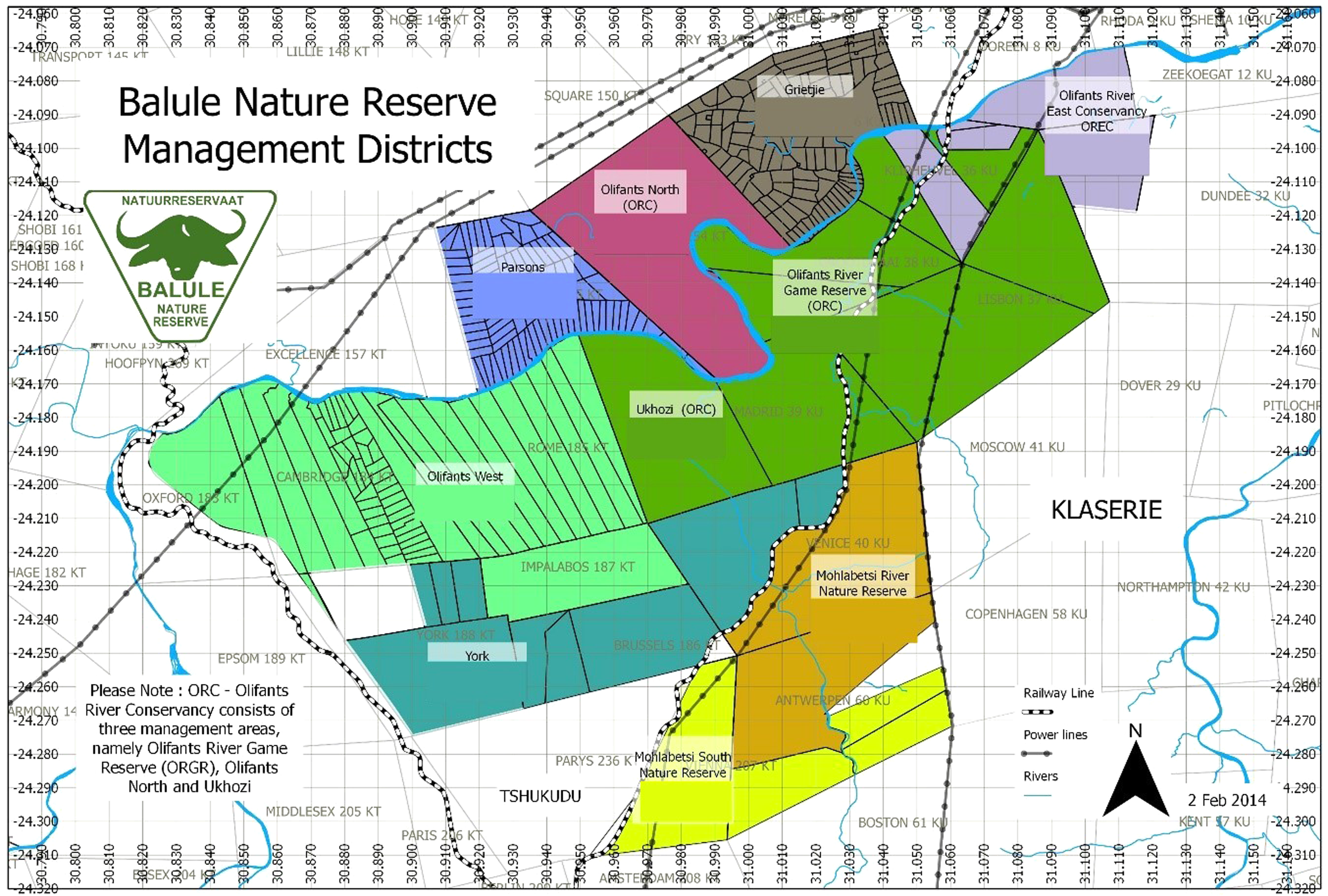
Location of Mohlabetsi south nature reserve (yellow) within Balule game reserve. 37
We have used the example of just one share block in Balule nature reserve to illustrate the legal entanglements in the landscape. There are at least six other private nature reserves that are part of the GLTFCA Co-operative Agreement, each of which comprises a mosaic of farms. In addition, some of these, including Umbabat private nature reserve have at least four share blocks inundated in a complex array of arrangements like JPNR. These arrangements are enabled by private property provisions which empower mainly white landowners to dictate how they participate in conservation, if at all (see also Lenggenhager and Ramutsindela, 2021; Ramutsindela and Sinthumule, 2017).
Some of the listed benefits of the co-operative agreement include: the value of land and brand associated with Kruger NP, and securing of existing land use through the declaration process. 25 Regarding the value of land, from 2003–2007 21 ha in parts of Balule went from 600.000 ZAR to 2.200.000 ZAR: ‘ … the reason for the increase in investment value is largely due to rarity and high demand for people wanting to own a part of the Kruger Park’. 26 These exclusionary agreements also fortify the Kruger NP and point to the broader neoliberal state's (Ashman et al., 2011; Narsiah, 2002) impetus to advance and support private capital, including the interests of privately managed restaurants and lodges within the state-owned Kruger NP.
The co-operative agreement, other legally binding agreements and the value of the land moors conservation-as-capital-accumulation in place. To disentangle an individual farm out of the 2 million ha Kruger NP landscape and overlapping judicial infrastructures is near impossible. Share blocks purport ‘to manage […] sustainable conservation of natural resources … ’ 27 but simultaneously immobilize conservation in the Lowveld, ultimately delegitimizing other claims to land. We conclude by discussing the tensions that this analysis opens.
Conclusion
We explored wildlife estates and share blocks as socioecological fixes by emphasizing three connotations of ‘fix’. First, wildlife estates and share blocks purport to ‘fix nature’ in response to global environmental degradation. They do this by evoking notions of a historical pristine environment that ought to be ‘restored’. In that sense, the ‘fix’ in the socioecological fix is not only spatial but also temporal, that is, these conservation spaces ‘are historically and culturally contingent representations of a particular nature aesthetic’ (Neumann, 1998: 11). However, parts of the Lowveld landscape were settled permanently by black people before the settlers arrived. Moreover, as this paper has shown, this region has always been in flux, thus notions of a historical pristine nature, are a fallacy conjured up to maintain white ownership over land. Furthermore, notions of ‘wilderness’ and ‘natural’, negates all the infrastructures meant to facilitate the transformations that enable and fix accumulation into space.
In addition to these contradictions, the quick fix presented by conservation and property developers also poses other challenges for biodiversity because some estates including HWE 28 and Raptors 29 tend to overstock wildlife, arguably so that residents and tourists have frequent animal sightings. This practice is known to have adverse impacts on the savannah bushveld and puts pressure on an already dry region. Furthermore, we have observed residents feeding wildlife which is strictly forbidden in all estates because it can habituate animals thus causing injuries. In addition, as the Department of Provincial and Local Government (2007) has noted, luxury residential developments, in a dry area such as the Lowveld, puts high pressure on water services. Finally, the appeal of wildlife estates in Hoedspruit is also based on the accessibility by air via the East Gate airport and many other landing strips within estates and reserves. While the magnitude might be difficult to quantify, the implications of flying into conservation spaces on the environment cannot be ignored. Consequently, it is not likely that estates have a net positive contribution to the environment writ large. After all, conservation-property developers will go to any lengths to enable high-modern, luxury consumption-driven lifestyles and hence willingly sacrifice environmental sustainability on the altar of white conservation imaginations and private profit.
This leads logically to the second connotation, which entails fixing to a geographical location. By submerging the farms within share blocks into complex legal arrangements, conservationists-cum-property developers ensure that they immobilize conservation in space and in turn use this to resist land claims. This is evidenced by the opposition of Jejane game farm share block to a land claim. 30 Amongst some of the reasons cited in the land claims court, is the issue of ‘restorability’, that is, it is contended that the land ‘cannot be feasibly restored. It is also accepted that some land can only be restored subject to present land uses’ 31 [italics added]. Read in light of the multiple complex legal arrangements we discussed, it is unsurprising that private landowners are resisting land claims based on feasibility. Where land claims have been approved in state owned parks, previously disposed communities and the national parks authority have entered into co-management agreements which ultimately ensure that conservation goals are not obstructed (Ramutsindela and Shabangu, 2018).
Fundamentally, these mechanisms employed in both private and state protected areas anchor conservation land use to particular geographies that are also sites of colonial and apartheid dispossession. The point we are making here is that these are not isolated incidents. Rather, a segment of the conservation fraternity in South Africa has been systematically and deliberately opposing attempts to redress past spatial injustices. Furthermore, and equally concerning, the neoliberal government through its environmental agencies and the courts has not only condoned but facilitated this socio-legal quagmire.
Third, we showed that these qualitative transformations are not merely unintended outcomes. Rather, socioecological fixes ‘secure the conditions and forces of production necessary for facilitating the accumulation of capital’ (Ekers and Prudham, 2018: 26). This reveals capitalisms’ propensity to continue to inscribe on the black racialised body the mark of exploitable labour. This is not unique to South Africa. In Tanzania and Kenya, Brankamp and Daley (2020: 116) show that ‘colonial conceptions and management of African bodies as labour has crucially informed postcolonial understandings of belonging and mobility’. While they make this observation to analyse contemporary labour migration in East Africa, it is crucial to observe how capitalism and its fixes under democratic states construct black bodies as ‘hardy’ labour, such that black peoples’ belonging in space becomes attached to the labour they render to the (white) capitalist class. This affirms earlier observations that capitalism and racism are intricately interwoven and that this manifests in space (Hawthorne, 2019), including conservation landscapes. Taken together, these mechanisms secure white control over land, animals and labour and thus exacerbate inequality. It is for these reasons that we argue that these conservation-property developments ‘conserve’ spatial injustice.
Highlights
Private developer-driven conservation spaces such as wildlife estates and share blocks are capitalist socioecological fixes.
These initiatives ‘fix’ conservation land use in place to the detriment of other claims to land.
Furthermore, they sacrifice environmental sustainability on the altar of white conservation imaginations and private profit.
Black people's belonging in private conservation is attached to the labour they render.
Ultimately, these initiatives reproduce and deepen spatial injustice.
Footnotes
Declaration of conflicting interests
The author(s) declared no potential conflicts of interest with respect to the research, authorship, and/or publication of this article.
Funding
The author(s) disclosed receipt of the following financial support for the research, authorship, and/or publication of this article: This work was supported by the Nederlandse Organisatie voor Wetenschappelijk Onderzoek.