
Abstract
While Singapore is often considered an island city in the singular sense, the city-state actually consists of many islands, with the Singapore mainland being by far the largest. While most of these islands traditionally had thriving indigenous communities, all have since been displaced over time as the islands were developed to service Singapore's economic and metabolic needs as a rapidly urbanizing and developing nation. Some of the islands have also undergone considerable transformation (through reclamation) which has had significant impacts on the ecologies of the offshore islands. This simultaneously allowed for the ‘ruralization’ of mainland Singapore to provide more green space for nature conservation, recreation and leisure. This paper will provide a brief history of these transformations, drawing on specific examples which serve to illustrate how Singapore's offshore islands have been redeveloped over time to service the nation-state and in response to the changing needs of the urban core. In doing so, the paper examines how spaces on the urban periphery are deeply bound up with processes of ‘urbanization’, given their important role in processes of urban metabolism. In this way, the paper contributes to recent work in urban political ecology which has sought to trace processes of urbanization beyond the city and render visible the socio-environmental inequalities produced therein.
Introduction: contextualizing the urbanization of Singapore's offshore islands
Over the past century, many smaller, offshore islands across the Asia-Pacific region have experienced drastic transformations to their social, physical, and symbolic landscapes. These changes have been brought about by transitions in political regimes and migratory flows, national and regional economic growth, and the shifting positions of these offshore islands within their respective nation-states. But such multifaceted development has also been accomplished at the expense of the diverse natural and cultural heritage of these offshore islands. As a short film shown at the 2014 exhibition at the National Museum of Singapore entitled Balik Pulau (‘Return To The Islands’) put it, “the story of Singapore's islands is one of growth, in size and economic significance, and loss, in numbers and nature, as habitats and homes give way to the needs of a modern city” (Ho, 2014). Indeed, while Singapore's offshore islands have played salient roles in powering the nation's economy and are deeply connected to the mainland, their visibility and historical significance to most Singaporeans remains negligible.
After Singapore left the new Malaysian nation-state in 1965, it became a city-state without a periphery to service the core. While this was later addressed through the development of regional growth triangles in the 1990s by integrating the city to ‘new peripheries’ in Johor and Riau to benefit from cheaper land and labour for the nation's growing needs (Bunnell et al., 2006; Sparke et al., 2004); an earlier and still ongoing strategy has been the repurposing of Singapore's offshore islands to serve particular functions, including landfilling, oil refinery, shipping and tourism. It is this particular strategy that the paper will focus on, by examining the evolution of Singapore's Southern and Western Islands over time from uninhabited or traditional Malay villages to industrialized or urbanized islands serving Singapore's various development objectives. It also considers how this has been accompanied by processes of ‘ruralization’ on Singapore's mainland and offshore islands to set aside green space for agriculture, recreation, leisure and nature conservation, as well as remnants of ‘old Singapore’ for the sake of tourism and place identity. In outlining these historical geographies of industrialization and spatial transformation, we draw attention to the continued (and new) inequalities of centre-periphery and socio-natural relations that have been constructed in the process. We also highlight the tensions that exist between urbanization and ruralization in Singapore, focusing on some of the emergent issues when the latter is mobilized as a compensatory approach to mitigate losses exacted by (although ultimately still for) the former on rural landscapes and processes. The paper focuses primarily on the period since 1965, which marked Singapore's independence and is when the most dramatic transformations have taken place.
Conceptually, the paper adapts insights from urban political ecology (UPE) which emphasize how a focus on the metabolic processes bound up with urbanization can demystify the visual and ideological exclusions of particular places and peoples that have been part and parcel of urbanization. This means to recognize the politics of such urban transformation as an extended form of ‘socio-ecological violence’ (Silver, 2018: 135). The concept of metabolism refers to the process of material exchange and interaction between human beings and nature through which both entities are transformed (Davies, 2019; Perrotti, 2020; Swyngedouw, 2006). We also build on recent work in UPE which has examined the ‘urban material baselines’ of cities, and how these are constructed through socio-natural processes such as land-reclamation (Dawson, 2021). Building on Silver (2018), we illustrate how land reclamation produces a form of socio-ecological violence that highly uneven, affecting particularly Singapore's Malay and indigenous orang laut communities that have been displaced for development.
Furthermore, we illustrate how landscape approaches can help to expand urban metabolism research within UPE to gain a deeper understanding of the socio-ecological and spatial dynamics bound up with urbanization. By examining the way in which Singapore's offshore islands have been simultaneously drawn into and transformed through the city-state's development, this paper contributes to recent literature conceptualizing processes of urban metabolism that extend beyond traditional city boundaries (Arboleda, 2016; Cantor, 2020; Connolly, 2019). We draw on insights from UPE as a spatialized analytical framework that can examine how sites on the urban periphery are deeply connected to urban metabolic processes within and beyond the city. As such, though Singapore is ideologically constructed as an independent island city without a hinterland to draw upon, it is in fact heavily dependent upon its material connections to its offshore islands that are separated from, but still deeply connected to the centre.
Methodologically, the paper is based on a much larger, two-year, interdisciplinary research project investigating the history, heritage and development of Singapore's Southern Islands (focusing on St John's, Lazarus and Seringat), spanning 2018−2019. This research was based on extensive archival research, interviews with former inhabitants of these islands, surveys with users of the islands, as well as review of existing secondary sources. In particular, we conducted several meetings with relevant statutory boards in Singapore, including the Singapore Land Authority (SLA), Sentosa Development Corporation (SDC), and National Heritage Board (NHB, which funded the research). We also made several research trips to the Southern Islands, at times with representatives from these organizations to share findings and learn more about the Islands’ management and future development plans.
This paper draws on insights gleaned from this larger project, in addition to more specific archival research and review of publicly available reports pertaining to the development of Singapore's offshore islands over the past fifty years. These sources include the Singapore National Library Board's e-resources which outline the geography and history of Singapore's offshore islands and relevant statutory boards which have overseen their development. We also examined parliamentary records pertaining to the reclamation of Singapore's offshore islands, annual reports of various statutory boards and corporations, as well as digitized news articles available from the NewspaperSG archive. This type of mixed-methods approach has been important to trace the historic and geographic socio-natures that have been transformed through the course of Singapore's development, and the political-ecological implications of these processes.
The empirical section of the paper is divided into different sections, based on the main functions that the islands were developed to serve: industry (petroleum and petrochemical industries); tourism and leisure; research and conservation; and finally, waste management. These sectors, particularly tourism and petrochemical processing are concentrated along coastal areas, and were central to Singapore's rapid development in the 1980s and 1990s. As we discuss, the Southern and Western Islands have been constructed as ‘spatial envelopes’ that can contain brownfield activities such as petrochemical industries or landfills, while allowing the simultaneous construction of a ‘modern’, clean and green Singapore on the mainland (Kaika 2005: 61; Lefebvre 1991: 351). While the islands have suffered significant ecological damage through the land reclamation and industrialization in the 1970s and 80 s, we also note how Singapore has more recently sought to conserve and restore the remaining ecosystems as it has developed. This has taken place alongside renewed popular interest in the Southern Islands, and subsequent efforts to create more awareness about their rural pasts, as well as cultural and natural heritages such as through museum galleries and guided trails. The paper concludes by reflecting on the hybrid rural/urban nature of Singapore's offshore islands and how they both augment and offset Singapore's increasingly urbanized landscapes.
Urbanization beyond the city: metabolisation and spatial transformation
Earlier work in urban geography has illustrated how territorial organization operates as a crucial force of production under capitalist systems. This is achieved through the integration and coordination of metabolic processes and infrastructural configurations that are financed by public and private forms of fixed capital and regulated through domestic institutional frameworks within geographically localised production systems (Cantor, 2020; Swyngedouw, 2006; Usher, 2018). Urban metabolism is a concept that has been adopted by urban political ecologists to theorize the extensive networks of resources, including food, energy, water, and other materials, that are integral to the development and maintenance of urban areas (Heynen et al., 2006; Swyngedouw, 2006). As scholars are now beginning to recognize, such metabolic and infrastructural configurations are increasingly taking place through forms of land reclamation that have physically reconstructed and extended the boundaries of cities (Comaroff, 2014; Dawson, 2021). Landscapes themselves can therefore be seen as socio-ecological infrastructures that provide the basis for urbanisation and development objectives, including economic growth (Perrotti, 2020).
Brenner (1998: 462) has elaborated how such forms of territorial (re)organization often underpin the construction, deconstruction, and reconstruction of geographical landscapes throughout phases of capitalist development within countries and regions. Moore (2014:12) has thus seen capitalism as a way of organising nature, becoming a metabolic engine that leads to the extension of the urban form beyond the city. As we will demonstrate below, Singapore's Southern and Western Islands have gone through a similar cycle over the past fifty years of Singapore's development.
The spatial transformation and reorganization that has taken place across Singapore's offshore islands since its independence can be explained by the need to create new infrastructures of territorial organization for subsequent rounds of expanded accumulation as the country developed. This has been achieved largely through processes of large-scale land reclamation, which has a tendency to function as ‘accumulation by dispossession’ through transforming public space into state-owned land (Grydehoj, 2015: 97; Harvey, 2003). Accordingly, the islands have been redeveloped to serve key sectors of the economy, from manufacturing, to tourism, and foreign investment. In this sense, they can be seen as ‘operational landscapes’ for industrial production, waste management, geopolitical strategies and spaces of recreation and leisure (Arboleda, 2016: 4).
As Huber (2017) has pointed out, the industrial sector is important to examine not only for its central role in socio-natural metabolism but also in producing many large-scale ecological problems. Indeed, the transformation of Singapore's offshore islands for industry and leisure has come at a high cost, as 60% of the country's coral reefs have been lost, in addition to much of the natural shoreline, and indigenous populations on the islands (International Year of the Reef, 2009). Highlighting such transformations illustrates how land reclamation processes intersect ‘with a politics of development, security and future prosperity’, but also marginalization and socio-natural inequalities (see Dawson, 2021). Additionally, the paper demonstrates how Singapore's offshore islands have arguably been rendered invisible in the national psyche over the course of the nation's rapid urbanization and development which has led to the further marginalization of their history and heritages.
Geographer Harvey (1989) has argued that the urban scale is the fundamental geographical anchor for each spatial reorganization, in this case being mainland Singapore. Therefore, the spatial transformation and reorganization of the city's periphery has had significant benefits for Singapore as a whole, but has in the process irreversibly transformed the socio-ecologies of its outlying islands. This is because such processes of capitalist accumulation and spatial reorganization always occur in political and social contexts shaped powerfully, if not exclusively, by central state power (de Koninck et al., 2017; Usher, 2018; Cantor, 2020). Indeed, Singapore is the quintessential developmental state, which places a premium on physical and economic development to secure its legitimacy (Neo, 2007). These unequal center-periphery relationships thus speak to the social and political relations that are bound up with the transformation of urban environments, which can be conceptualized through the lens of socio-ecological violence. As Silver (2018: 133) explains, this form of violence is understood as “unbounded from infrastructure, positioned as a dialectical, multi-scalar and historical process of socio-ecological transformation that takes into account the co-produced natures that constitute the city and its hinterland”. As we will demonstrate in the following sections, the ecologies and the former inhabitants of Singapore's offshore islands have assumed most of the negative effects associated with the significant spatial transformations taking place over the past fifty years.
The dialectical relationship between city and countryside is central to the conceptualization of cities within urban political ecology. One of the foundational texts in this regard is Bill Cronon’s (1991: 384) book, Nature's Metropolis, which argues that ‘urban and rural landscapes … are not two places but one. They created each other, they transformed each other's environments and economies, and they now depend on each other for survival’. Just as offshore islands may suffer huge losses from the rampant urbanization and development of and on the mainland, they can also be subject to (state) efforts to preserve what is left through processes of ruralization. Ruralization here emphasizes the salience of, and pivoting towards, not only traditional ‘rural’-type processes (e.g. farming, animal husbandry, the extraction of raw materials, etc.) (see Cronon, 1991), but also ‘rural’-type landscapes and life-ways (e.g. natural surroundings, kampong landscapes, etc.) (Blanchette, 2019). This serves to primarily feed into the needs of urban population such as for nostalgia, nature or to counteract the social and ecological costs of urbanization towards supplementing food security, and enhancing mental well-being and/or tourism revenues (Wheeler, 2017). This perspective emphasizes the hybridized and relational character of landscapes and processes of urban metabolism bound up with them (Connolly, 2019; Neumann, 2011; Perrotti, 2020). Conceptualizing urbanization and ruralization as processes helps us to then capture the complex reality of socio-spatial formations and relations that defies being on either side of the spectrum, such that ‘the distinction between urban and rural [should be seen] as a continuum rather than as a categorical distinction’ (Krause, 2013: 236). Under this framework, urbanization is but one of the agents of change within cities, ruralization being another, the latter a way to meet the needs of urban populations while still pursuing urban economic growth and development, although this has not been without accompanying issues, as we discuss below (Blanchette, 2019).
Early work in UPE has documented the material and infrastructural connections forming the ‘socio-spatial continuum’ between city and countryside in (and beyond) cities like Athens, New York, London and Chicago (Cronon, 1991; Gandy, 2002; Kaika, 2005). This research has highlighted the fetishization of urban infrastructural networks like water, electricity and gas pipelines which are often hidden from view but yet crucial to the functioning of the city (see Kaika and Swyngedouw, 2000; Usher, 2018). In this way, UPE offers a framework to understand cities as not detached from their hinterlands, but rather stitched together through extended socio-natural flows (Silver, 2018). The economic growth of the city was also seen to be increasingly tied to a regional urban ecology within which undesirable socio-natures would be gradually displaced by an intensely reworked but also more unequal landscape (Gandy, 2002; Kaika, 2005). However, Kaika (2005) notes that these socio-natural processes and materials - though kept apart - are very much dialectically related through a process of interdependence, which is required for the ongoing functioning of the whole.
In the same vein, taken as processes, the urban too cannot exist without the rural. They are two sides of the same coin that function to provide for the multi-layered needs of our growing city-regions (see Jacobs, 2012). As such, Kaika (2005: 62) concludes that there can be “no margin without a center; no periphery without a core”. In order to understand these networked spatial relationships and metabolisms, UPE research is beginning to adopt an explicitly spatialized, or landscaped approach in order to integrate key processes of socio-natural metabolisms, power relations and discourse bound up with the ordering of urban environments (see Connolly, 2017; McKinnon et al., 2019; Neumann, 2011; Perrotti, 2020). As we demonstrate in the following sections, such efforts can help expand the urban metabolism agenda beyond ‘functional analogies’ and toward a greater understanding of the intertwinements between social, spatial and biophysical dynamics that produce new forms of hybridized urban spaces (Perrotti, 2020: 9)
Exploring the margins of the city is therefore important as it disrupts the boundaries between socially constructed categories such as social, natural, urban and rural. It also opens up space for understanding the social impacts of such forms of spatial re-organization by highlighting the people, places and histories which are often rendered invisible through such processes. For example, the case of Singapore's offshore islands presented below illustrates the choreography of materials, places and people that have been metabolized, transformed, and displaced in order to facilitate the rapid socio-economic development of the city-state.
Singapore's offshore islands: From rural villages to spaces of industry, tourism and leisure
Singapore currently has a total of 54 islands - down from 77 after the amalgamation of smaller islands through land reclamation works over the past 50 years. Such processes of land reclamation have been an enduring component of Singapore's urban development ever since its initial ‘establishment’ by the British in the early 19th century. Indeed, as De Koninck et al. (2017) have shown, Singapore's surface area has increased by nearly a quarter (or 135 km2) since the mid-1960s through land reclamation. They refer to this process as Singapore's ‘permanent territorial revolution’, which has been justified by Singapore's chronic ‘scarcity of land’ needed to generate economic growth and house its growing population. Singapore and its offshore islands are thus illustrative of the perpetual churning of socio-spatial formations under capitalism and the numerous metabolic flows involved (see Brenner, 2013: 99).
While many of these islands have long and important histories, most do not even exist “on the margins of [Singaporeans’] mental landscapes” (Ho, 2014) as subsequent development imperatives have transformed them beyond recognition. A few of the larger islands were once inhabited by vibrant Malay and Orang Asli (indigenous people) communities, frequently within villages made up mainly of kampong houses along their coasts that straddle between land and water (Wee and Benjamin, undated). They made their living by fishing, harvesting crops like banana and tapioca, and collecting and selling corals that have been refashioned into necklaces and other items (Singapore Free Press, 1960).
However, the 1970s saw a rapid depopulation of these islands. Some moved away from their home islands to work on industrialized islands like Pulau Bukom or mainland Singapore in the hopes of steady incomes, while others were pressured to leave so as to make way for the islands’ repurposing to different uses (Cornelius-Takahama, 2019). This was made necessary especially after Singapore lost its hinterland following its departure from Malaysia in 1965. Subsequently, the islands came under the jurisdiction of statutory boards, such as the Sentosa Development Corporation (SDC) and Singapore Land Authority (SLA), depending on their functions. As a result, where the city ends and rurality begins is unclear, as Singapore's “city effects pulse outwards, drawing in rural-based lives and spaces, creating hybrid urbanisms” and a new type of city-state (Jacobs, 2012: 413)
While the rapid urbanization and development of Singapore in the 1970s and 80 s had severe socio-ecological consequences for the islands, this enabled the provision of additional green space on the mainland. This emerged particularly in the 1990s in association with various Green Plans put forward by the (then) Ministry of Environment to make Singapore a ‘Garden City’ (see Neo, 2007). This speaks to Walker’s (2007) observations regarding the way in which the urbanization of formerly rural spaces - either through use as landfills or industrial sites - exists alongside and facilitates the ruralization of the city through the expansion of public green space. Nostalgia for how Singapore used to be has also manifested in state policies to, within limits, continue maintaining some of our old rural landscapes (both on the mainland and beyond) such as in the forms of traditional housing forms and farming practices, some of which now exists only on Singapore's offshore islands such as in Pulau Ubin. As such, taken as processes, the urban and the rural are not mutually exclusive; but exist in a dialectical relationship of concentration and deconcentration involving the redistribution of people and infrastructures (Krause, 2013).
The modern history of Singapore's offshore islands is thus illustrative of the interconnectedness between the urban and the rural highlighted by Cronon (1991), as many of these islands were designated as official rural areas and accordingly came under the control of the Singapore Rural Board (SRB) until this was abolished in 1965 (Cornelius-Takahama, 2019). Other than Pulau Ubin, Pulau Tekong Besar and Kechil, and Serangoon (Coney) Island, located to the north or northeast, most of the islands lie off Singapore's southern coast For planning purposes, Singapore’s offshore islands to the south are divided by the Urban Redevelopment Authority (URA) into two clusters: the Southern Islands group and the Western Islands group. Singapore's Southern Islands group comprises eight islands directly to the south of the mainland and the Western Islands group consists of seven islands situated more to the southwest (see Figure 1).
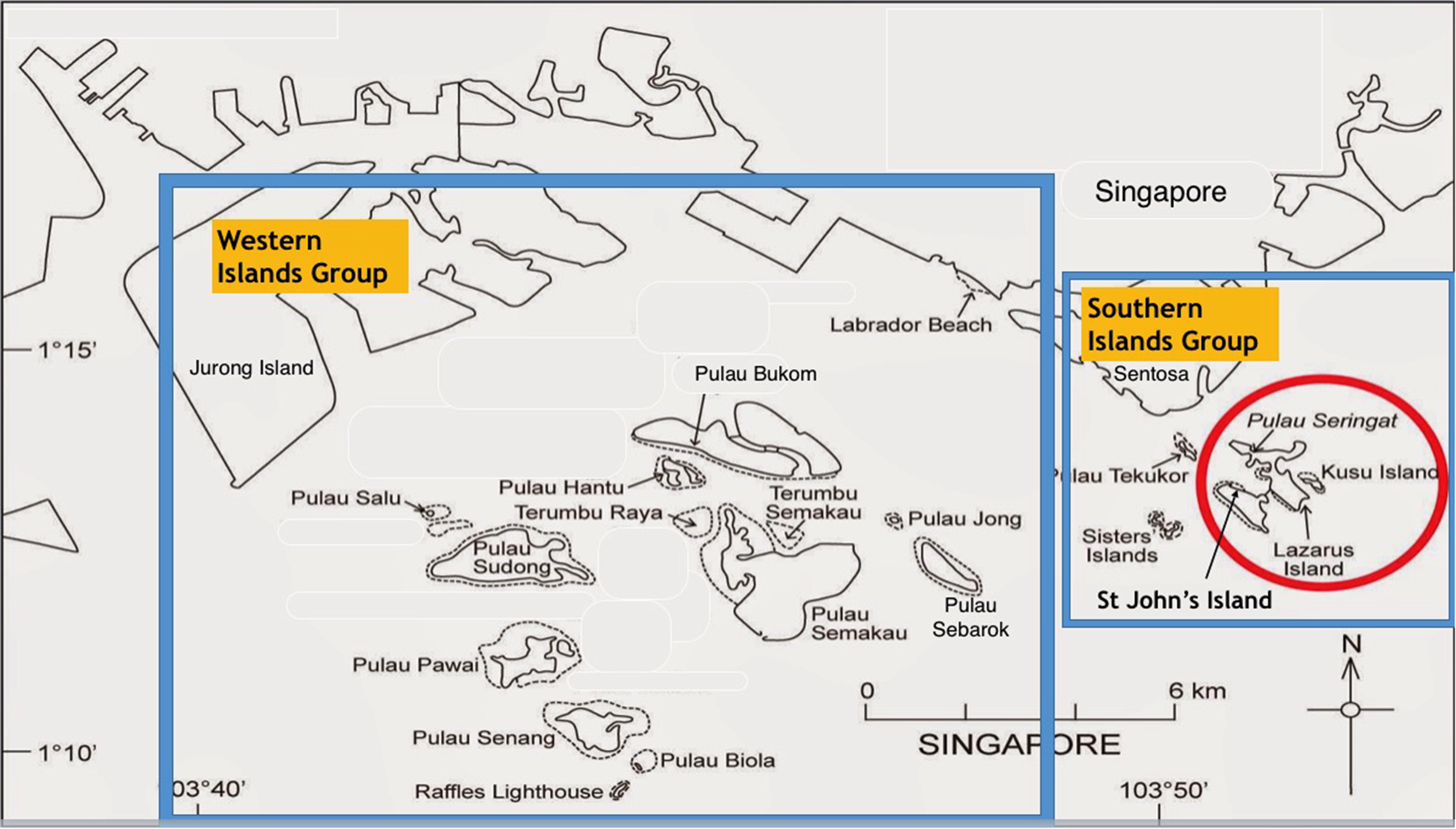
Map showing the location of Singapore's southern and western islands, with the southern islands of St john's, Lazarus and kusu circled as the focus of our field research.
The rest of the paper will now highlight some of the ways in which some of these islands have been transformed over the decades in order to service the nation's economic, social and metabolic needs, focusing specifically on the impacts of urbanization on the formerly rural landscapes of these islands. In this way, the islands can be seen as: “indicators of contradictory yet interconnected processes of socio-spatial restructuring under conditions of ongoing industrial, labor, politico-regulatory and environmental reorganization” in Singapore (Brenner, 2013: 100). 1 The paper then highlights how the government has sought to redress the high costs of these early urban developments in recent decades, especially in terms of the natural environment. As we will show, this has involved developing a blueprint, or territorial framework for the production of the islands’ future spatial forms and social, ecological and economic functions.
Shifting of the sands: charting the evolution of Singapore's petroleum and petrochemical industries
The petroleum and petrochemicals industry has been central to Singapore's economic success, as a strategic cluster underpinning the nation's economic development. This is one of the early industries - along with the electronics manufacturing sector - which helped build Singapore's reputation as a value-added economy, rather than as a producer of primary products. However, this was achieved at the expense of the richly dense mangrove swamps, coral reefs, and local indigenous communities of Singapore's offshore islands, due to the significant amount of land reclamation required to house the industry over the decades. Yet, due to the top-down nature of planning and development in Singapore - especially in earlier decades - much of this went uncontested. Moreover, as Huber (2017) has noted, industrial sectors often operate without much resistance despite the massive metabolization of physical space, energy, and waste and should therefore constitute a key area of concern for political ecologists.
One of the main islands hosting Singapore's petrochemical industry is Pulau Bukom, which is an amalgamation of the former islands Pulau Bukom Besar and Pulau Bukom Kechil (‘besar’ meaning ‘big’ and ‘kechil’ meaning ‘small’, in Malay). It houses an integrated oil and petrochemicals site with manufacturing facilities for fuels, lubricant base oils and specialty chemicals (Shell Singapore, n.d.). 2 Pulau Bukom's association with the petroleum industry originated in 1891 for the storage of imported kerosene from Russia by a local merchant Syme & Company (Huff, 1997). The government rejected the company's application to store bulk petroleum on mainland Singapore, which led to the decision to store the kerosene on Bukom due to its proximity to the mainland and deep, sheltered harbor (Makepeace et al., 1991). Pulau Bukom was greatly expanded through land reclamation in the first half of the 20th century, which established it as the largest centre for oil storage, blending, packing and bunkering in Southeast Asia by 1959, when the refinery was established (Huff, 1997; Straits Times, 1 December, 1959). 3 The oil refinery employed workers both from the mainland and also from surrounding islands such as Pulau Sakeng. Ironically, the development of Pulau Bukom as a site for oil refinery had also displaced its former inhabitants initially to Pulau Sakeng – thus leading to a population explosion on this tiny island – before the residents were later relocated to the mainland, as we discuss below (Wee and Benjamin, undated).
Subsequently, neighboring islands and islets were also reclaimed in order to provide space for the manufacturing of petrochemicals which was seen to be more economically lucrative (Yun and Jin, 2009). Pulau Ular was previously a submerged coral reef with two visible islets that was reclaimed to form part of the petrochemical complex (The Straits Times, 24 October, 1974). The island was reclaimed using earth from hills on Pulau Bukom Besar, Club Hill (now Club Street on Mainland Singapore) and Pulau Ubin (off the northeastern coast of Singapore), which was a common reclamation strategy in the 20th century before increased land reclamation required the import of sand from neighboring countries (Koh and Lin, 2017). 4 This illustrates the way in which redevelopment of individual islands can cause long-term ecological degradation to surrounding islands (see Chee et al., 2017). It is also representative of the process of creative destruction involving the reorganization of existing infrastructures and socio-environmental landscapes for the continued accumulation of social and economic capital (see Brenner, 2013:105; Grydehøj, 2015).
The petrochemical complex on Pulau Bukom presently spans the cluster of islands that include Bukom Besar, Bukom Kechil, Pulau Ular and Pulau Busing (‘busing’ meaning ‘sand dune’), the latter three of which have been connected through land reclamation since 2010 (Groen, n.d). Pulau Bukom Kechil was also expanded by 48 acres through reclamation in 1975. Such connection of previously separate islands has been a common strategy for increasing developable land area of Singapore's offshore islands since the early 2000s. Nearby Jurong Island is also a center of Singapore's chemical and energy industry, which was targeted as an area for primary investment and growth by the Singapore Government in the 1970s (Lim, 2004). However, as with Pulau Bukom, this economic strategy required more industrial land which was scarce on mainland Singapore, so reclamation of the seafront along offshore islands became the preferred solution (JTC, 1984). Jurong Island was thus formed through successive land reclamation work connecting seven offshore islands, completed in 2009. Three of the constituent islands - Pulau Ayer Chawan; Pulau Merlimau and Pulau Pesek - had earlier become the focus for Singapore's strategy to maintain its ‘global competitive edge’ by building up and integrating the petroleum and petrochemical industries in the 1980s. Tracing the transformation of Singapore's offshore islands overtime can thus illustrate how land reclamation is integral to securing the future prosperity of cities and nations, particularly in rapidly urbanizing regions (Dawson, 2021: 18).
By 1985, four other southwestern islands had already been reclaimed and connected to Jurong Island: Pulau Seraya for a power station; Pulau Ayer Merbau for Singapore's first petrochemical complex; Pulau Pesek Kechil in 1985 for a holding station for imported pigs; and Pulau Sakra for future industrial uses (Lee, 2000). Together with Ayer Chawan; Merlimau and Pesek, these islands comprised 991 hectares, which were then transformed into a massive island of 3000 hectares over a period of 24 years, one of the largest land reclamation projects ever to be completed in Singapore (Today, 2009; Yang and Lay, 2004). Glaser et al. (1991: 365) have thereby argued that land reclamation in Singapore can be seen as an index for the rate of economic development, as many reclamation projects were driven by rapid growth in industrial infrastructure designed to extend the status of the country as a global commercial center.
As Carpenter and Ng (2013) have argued, the creation of the artificial Jurong island complex is one of the main reasons for Singapore's emergence as a global leader in the chemical industry. By 2014, the island produced 1.5 million barrels of refined oil, making Singapore one of Asia's top ten exporters of refined oil (Lim, 2004). The petroleum, petrochemical and specialty chemical industries together form a key pillar of Singapore's economy, which in 2014, accounted for approximately 34% of total manufacturing output worth over S$100 billion (Department of Statistics, 2016). There are also significant financial and commercial networks associated with the industry, as Singapore is now a leading hub in Southeast Asia for petroleum exploration and production (de Koninck et al., 2008). Singapore's reconstructed and expanded island landscapes can therefore be conceptualised as catalysts of Singapore's rapid socio-economic growth by providing the terrain for essential industrial infrastructures that were not feasible on the mainland (Perrotti, 2020: 4). Yet, as noted above, the development of these islands for the chemical industries also led to the loss of mangrove habitats and resettlement of its former inhabitants, some of whom had settled there as early as 1828 (Savage and Yeoh, 2013: 311). While there is no way that these losses could be compensated fully on hindsight, there has been attempts to ruralize this highly built up area through nature conservation and aesthetics. While Singapore's petrochemical industry was initially sited off the coast of the mainland due to potential negative externalities, the second master plan for Jurong Island explicitly ties it into the city-state's larger green vision through the creation of a ‘green aesthetic’ in the form of tree-lined roads and the restoration of natural ecosystems (Yang and Lay, 2004). This strategy is consistent with other islands like Semakau (discussed in the next section), which combine brownfield sites with ecological conservation measures and recreational amenities. Jurong Island is also being prepared for possible future conversion into a site for the generation of renewable energy, as the petrochemicals industry is recognized to have finite economic viability (Yang and Lay, 2004). The island can therefore be seen as a territorial framework for the production of Singapore's future urban landscapes and economic pathways (see Brenner, 2013: 100). In this way, the nation's engineered offshore islands could become vehicles for the construction of novel urban forms and socio-natural metabolisms which are potentially driven by other forces than just ‘the logic of capital’ (see Perrotti, 2020, 4) although ironically this group of islands are still largely off limits to the public.
Pulau semakau: The hidden abode of Singapore's incinerated waste
Pulau Semakau is one of Singapore's western islands and the nation's only offshore landfill, which is made up of mostly incinerated ash. Incineration reduces the volume of waste by 90% making it an effective waste-management strategy for Singapore due to the shortage of available land within the country. The transformation of Pulau Semakau into a landfill in 1990 (operationalized in 1999) also saw the reclamation of a nearby island, Pulau Seking, which was connected to it. The total reclaimed land consists of 220 hectares of swamp, foreshore and seabed around Semakau, which was initially only 29 hectares in area (Singapore Parliament, 1975). The total landfill area across the two formerly separate islands now encompasses 350 hectares, with a capacity of 63 million cubic meters of incinerated ash (Chia et al., 1987; Ng, 2012; See Figure 2). According to a report in the Business Times, this made Semakau Landfill “probably the largest off-shore dumping ground in South-east Asia” (Lee, 1989: 20), and is in fact the first man-made offshore landfill created mostly out of sea space (Chia, 2019). Its accolades as a landfill, however, obfuscates the fact that much of the islands’ heritage was lost in the process as its original inhabitants and their settlements were displaced for the reclamation work.
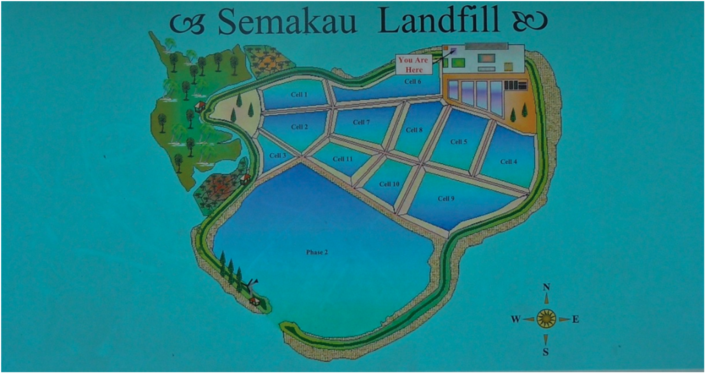
Signboard showing map of semakau landfill (photo by Creighton Connolly).
Pulau Seking, for instance, was home to the last Southern island kampong (village) community, the population later supplemented by those from Pulau Bukom as they were displaced from the petrochemical development there. At its height, Pulau Seking had a population of over 300 people, until the islanders were resettled to mainland Singapore to make way for the landfill in the 1990s (Cornelius-Takahama, 2019). Much earlier, there were also about 200 families living on Pulau Semakau although they had already moved to the mainland in 1977 for better employment opportunities (Ng, 2012). Seking was made up of a Malay village on the western side of the island and a small Chinese village at the south-western end (Chia, 2019). Many of them were descendants of the indigenous Orang Laut (or sea nomads) who lived in some 76 kampong houses straddled between water and land.
However, in 1989, it was proposed that the site, along with Pulau Semakau, which also had its own villages, should be used for a landfill due to a lack of space on the mainland. There was a public appeal to preserve the island and its rich (Malay) cultural heritage after this announcement was made, but was rejected as it would have cost an additional $130 million for an alternative landfill site (Cornelius-Takahama, 2019; Singh, 1986). At that time, the waste produced in Singapore totaled 1.9 million tonnes annually, and was expected to grow to 2.3 million tonnes a year by the year 2000. It was therefore predicted that both existing landfills on the mainland, in Lim Chu Kang and Tampines at the extreme northwest and northeast respectively, would reach full capacity by the late 1990s, which proved to be accurate (Lee, 1989; Chan, 2016). Other possible sites that were considered on the mainland (such as Punggol, in the Northeast) were needed for new housing estates to accommodate the growing population (Chan, 2016). After Pulau Semakau took over their function, the original landfill sites have become important wetland reserves (Sungei Buloh and Lorong Halus, respectively), contributing to the ruralization of those areas (Lee, 1989).
The case of Semakau further demonstrates the ways in which the socio-ecological transformation and degradation of Singapore's offshore islands has allowed for the restoration and conservation of nature on the mainland. Indeed, the location of the new landfill offshore, out of sight of most Singaporeans and visitors, can be seen as part of an attempt to build a ‘clean and green’ Singapore, which of course requires the relocation of brownfield sites into the periphery. The example of Semakau Landfill thus shows how the compounding marginality and exclusion of Singapore's indigenous communities are deeply connected to the government's efforts to link the needs of waste management with sustainability and ‘green city’ indicators. Moreover, the case reveals the techno-managerial nature of spatial planning in Singapore, which has been dominated largely by politicians and statutory boards, rather than through truly democratic forms of governance and consultation. As Grydehoj 2015: (104) notes, the terrestrialisation of marine territory – though frequently controversial and with deleterious effects on adjacent communities – serves to disenfranchise and make ambiguous non-elite stakeholders, precisely because of the relative lack of both contestation over reclamation in the public realm, and critical research on the topic.
Furthermore, and building on Kaika (2005: 58), the placement of heavy industry and landfills on the southern islands was a means of - and a basic precondition for - building a ‘modern’ Singapore through separating ‘good’ from ‘bad’ natures. In other words, it is a process of separating the metabolic transformation of nature from that of urbanization. At the same time, Kaika argues, the domestically metabolized ‘bad’ nature (e.g. pollution, waste, etc.), become part of the outside, or the antipode to the protected, interior of the nation. For instance, Singapore's waste is incinerated at one of four plants on the mainland, and this is then transferred by barge along with non-incinerable waste to Pulau Semakau from Tuas Pier, at the southwestern edge of the mainland. The waste - approximately 2300t per day - is transferred at night, keeping it out of sight (Chan, 2016). As such, while modernity in Singapore has been premised upon making ‘nature’ an intrinsic part of modern life, it has simultaneously positioned many of the Southern Islands as externalized ‘others’ for the processing of metabolized natures and fueling economic growth. Moreover, the externalization of the city's incinerated ash has also resulted in the further marginalization and displacement of Singapore's indigenous orang asli communities.
Upon construction, it was anticipated that once filled, the reclaimed land on Semakau could be used for more development (Lee, 1989). While this has not yet happened, the original reclaimed area at Semakau was filled by 2016, so the NEA embarked on plans to start work on phase two of the Semakau Landfill in 2013 which would meet Singapore's projected waste disposal needs up to 2035 and beyond (NEA, 2015). A wind turbine and solar panels were installed in 2006 in order to enhance the financial and environmental sustainability of the landfill (Tan et al., 2009).
In contrast to original ideas of developing the land, the site has, at least for the moment, become used for nature conservation to protect the significant coral reefs in the area, its inter-tidal habitats, support mangrove restoration and the construction of silt curtains to minimize sediment damage of nearby sea grass, reefs and sandy shores (International Year of the Reef, 2009; Kolesnikov, 2005). 5 While this may seem like a unique combination of land-uses, the conversion of landfills into parks is a common phenomenon in other countries, as landfills become destinations for recreation due to land constraints and cost (Harnik et al., 2006). In the spirit of ruralization, Pulau Semakau is thus partially accessible to the public for recreational activities such as inter-tidal walks, stargazing, birdwatching and fishing (Ng, 2012). This achievement is promoted by the government as a strategy of balancing the goals of waste disposal needs (as a by-product of urbanization) with nature conservation, to mitigate against the complete subsumation of cultural and natural heritage (Blanchette, 2019: 88; Cantor, 2020). In fact, Semakau landfill is widely celebrated as an “eco-dump”, and regularly receives officials from other countries hoping to learn from Singapore's expertise in waste management (Chan, 2016).
However, Chan (2016) has noted that the landfill actually has numerous ‘hidden’ socio-ecological consequences both within and beyond Singapore, particularly related to the dredging of sand required for the reclamation, which would have had environmental costs for those places and is becoming increasingly unsustainable (see also: Comaroff, 2014). In addition, waste incineration can produce harmful air pollution (particularly dioxins and furans produced from the burning of plastics and other materials) which can be particularly harmful to communities that live in the vicinity of incineration plants. There are further concerns regarding the potential leaching of toxins from the incinerated ash into the ocean, which will require continual monitoring throughout and beyond Semakau's operational lifetime (Chan, 2016). Landfilling of incinerated ash has therefore been increasingly criticized as a viable method of waste disposal due to the possibility of contaminating water supplies and the emission of greenhouse gasses into the atmosphere (Gandy, 1994). This demonstrates the socio-environmental inequalities that are produced through the transformation of the urban landscape to serve the capitalist political economy, even in seemingly ‘green’ and ‘sustainable’ ways (Swyngedouw, 2014). As such, even when land is reclaimed with the public interest in mind (e.g. for the creation of public parks or green space), such spaces can in fact appear more beneficial than they really are (Grydehoj, 2015: 110). The remnants of, and relics belonging to, the rural villages on the coast of the island also serve as reminders of the costs of its transformation into a landfill, although there has been no plan yet for restoring this.
Tourism and leisure spaces
Many of the Southern Islands had been targeted for expansion through reclamation and subsequent development into recreational areas by the mid-1970s to make up for the loss of recreational land resulting from the development of Changi International Airport (The Straits Times, 12 April, 1976). Reclamation works started at Changi in 1978–1982 for the expansion of the existing military airport there into the current international airport, and the addition of a second runway (Straits Times, 30 July, 1975). This area was previously a space for public recreation, and it was thus seen as socially necessary to create other green ‘lungs’ and public parks for the use of residents, particularly with the rapid development of more public housing flats across mainland Singapore (Straits Times, 2 February, 1978). This section of the paper will discuss the development of these islands over the past fifty years, and how they have intersected with Singapore's growing tourism industry over that time, and relatively more recent goals related to nature conservation.
Pulau Sentosa was one of the freely accessible green lung areas that was earmarked by the Singapore Government to make up for the loss of space near Changi in the early 1970s. Formerly known as Pulau Belakang Mati - meaning ‘the Island behind Death’ in Malay - Sentosa Island was initially populated by Malay, Bugis and Chinese villagers although a mysterious epidemic in the 1840s almost decimated many of the inhabitants (Turnbull, 1972). 6 The island then functioned as a British military base since the late 19th century, before being developed into a “tropical island resort and South Sea Island paradise” in the 1970s (Campbell, 1967; Ho, 2015; The Straits Times, January, 1969). This required renaming the island in 1970 to reflect the island's new image (Sentosa means “peace and tranquillity” in Malay). Its ‘dark’ history is now completely erased from the island (The Straits Times, March, 1972).
Reclamation work began in 1973 in Sentosa with the creation of a swimming lagoon and some foreshore structures, and expanded in 1979–80 with the joining of Pulau Selegu and Sarong Island to create more land for future development. This enlarged the island to 500 hectares (ha) from its original size of 263 ha, at a cost of S$68 million (Miharja, 2014). The reclamation was intended to create more land for development, “improve the visual impact on visitors”, and align with the recommendations of Singapore Tourism Promotion Board's Tourist Product Development Plan to redevelop the island into a ‘Tropical Island Resort’ to combat falling tourism numbers in the 1980s (STPB, 1988; see Figure 3). This involved the planting of coconut trees along the fringe of the reclaimed land “to preserve the image of a tropical island” and enhance the green aesthetic for (foreign) visitors to the island (The Straits Times, February, 1978: 28). A cable car was also built linking the island to Mount Faber on the mainland in order to facilitate transport to the island and increase the number of visitors.
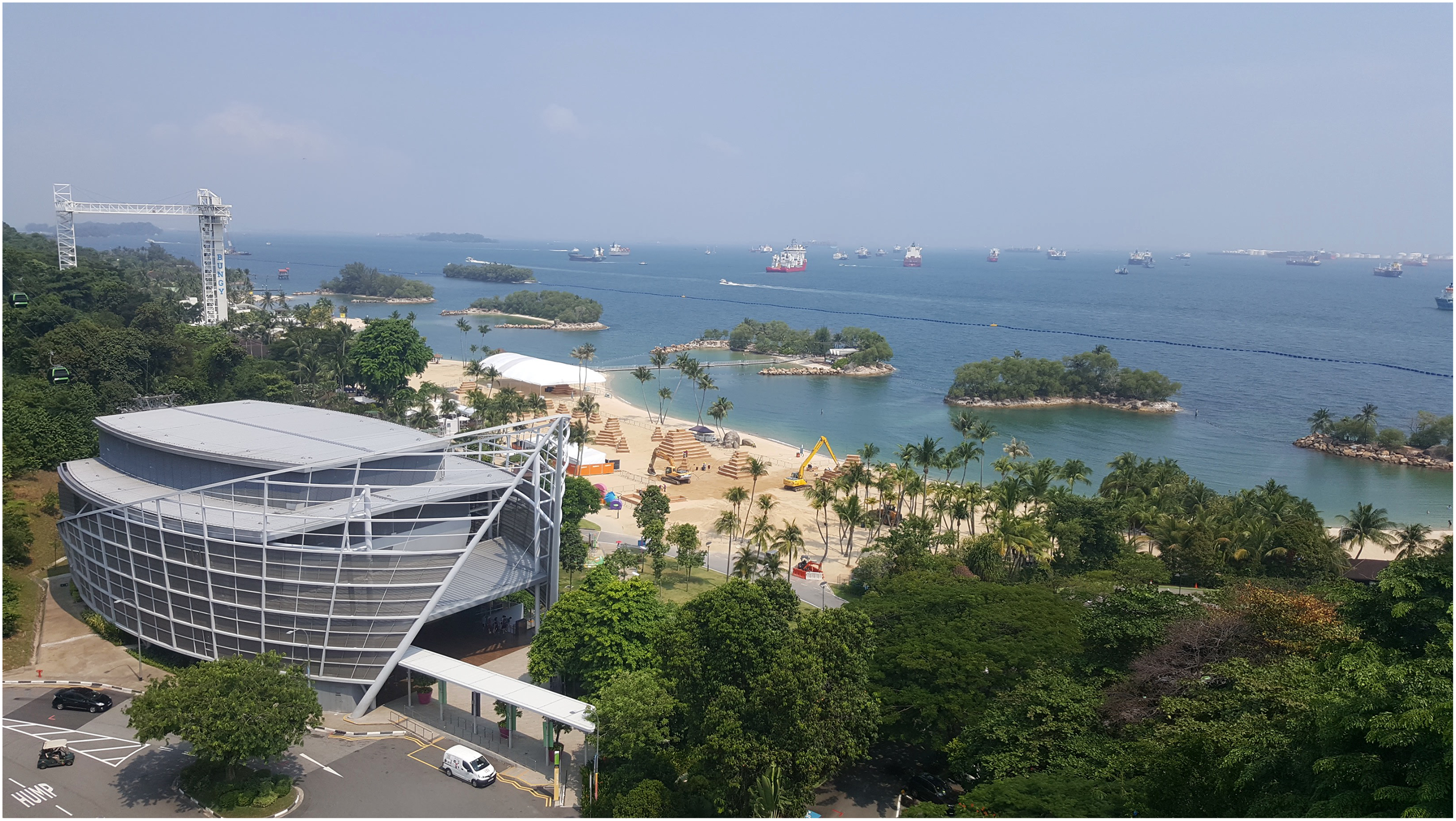
Photo taken from sentosa island, showing the heavily landscaped siloso beach, and the western islands in the background (photo by Creighton Connolly).
Since the 1990s, due to the massive loss of natural ecosystems and biodiversity wrought by rampant urbanization of the city-state, the Government sought to reinvent itself as a ‘garden city’ or ‘city in a garden’ (see Henderson 2000). This involved the development of nature tourism and ‘nature trails’ around the city, which would help to achieve its goals of becoming an international tourist destination (Chia et al., 1987). The state began to also turn its focus on, and support of, the enhancement and preservation of Singapore's green lungs and natural heritage on the mainland as well as the offshore islands. Calls to safeguard the coral reefs, in particular, continued over the years and culminated in Singapore's first Blue Plan in 2009 which sought to apply Singapore's ‘garden city’ concept to the sea (Abdul Rahim, 2018). An artist was also recently commissioned to paint murals on some areas of Sentosa to serve as reminders of the history of the island as well as rural sceneries and practices that used to exist in situ, such as kampong and kampong landscapes, all aimed towards ensuring that Singaporeans do not forget about the island's humble beginnings (Tan, 15 November 2019).
Plans to further develop Sentosa emerged in 1996 under the then Singapore Tourism Promotion Board's (STPB) strategic plan: ‘Tourism 21 – Vision of a Tourism Capital’ which sought to identify tourism as a national industry, and develop new spaces of tourism and leisure (Henderson, 2000). This vision had significant implications for Sentosa, which led to the redevelopment of the island, and the creation of new leisure spaces. Starting in 1996, Sentosa Cove, a luxury residential waterfront project spanning 117 hectares was constructed through additional land reclamation in order to diversify the island's revenues and investment from tourism, and to attract super-rich investors. The resort was designed by French waterfront architect Bernard Spoerry, based on Port Grimaud in the French Riviera designed by his father to resemble a “canal-laced marine village resort” (Lu, 2012: 51; Pow, 2011). The fully gated enclave features a total of 2600 homes including oceanfront villas, mansions and condominiums containing their own private yacht berths and multiple swimming pools. 7
Embedded within the resort is a 400-berth marina village with 10 spots for mega yachts, and two adjacent golf courses. Sales began in 2003, with over half of the property sold to foreigners, as it is the only landed property in Singapore that can be purchased by foreign buyers (The Straits Times, August, 2014). Sentosa Cove is in this way representative of a new phase in Singapore’s development strategy, which goes beyond merely manufacturing and tourism industries to “transform the city-state into ‘an oasis of talent’ that will serve as a cosmopolitan lifestyle hub for global business elites” (Pow, 2011: 386). Subsequently, in 2010, Singapore's first ‘integrated resort’, Resorts World Sentosa (RWS) opened at a cost of $6.5 billion, featuring a Universal Studios theme park and casino, which helped increase Sentosa's annual visitorship by more than two-fold in 2011. This indicates the ways in which land reclamation projects, and particularly iconic artificial islands are now presented as hallmarks of ‘world city’ status yet are simultaneously associated with privatism, exclusion, and hyper-inequality (Grydehoj, 2015: 104).
St Johns Island was another island earmarked as a holiday island in the mid 1970s, following the closure of the former Opium Treatment Centre in 1975. There were even plans for a golf course, restaurants and more to be established, but - as with Sentosa Cove - the focus eventually fell on Sentosa, and all funding went there. At one point there was also a plan for an Integrated Resort (casino) to be established here, although that was eventually located at Sentosa and Marina Bay on the mainland (but built exclusively on reclaimed land). As Lu (2012) noted, this could be due to concern with damage to the coral reefs surrounding the Southern and Western islands that emerged in the early 1990s.
Since the early 2000s, St John's Island was conjoined, through land reclamation and manmade causeways, with neighbouring Lazarus and Seringat Islands at a cost of S$50 million in order to ‘beautify’ the islands. Kusu Island - a short distance from Lazarus - has been enlarged to nearly six times its original size, from 1.5–8.5 hectares since the 1970s through land reclamation and is used primarily as a seasonal pilgrimage site, but also for tourism (Lu, 2012). New piers and rest pavilions, along with a new beach, were established for local day-trippers, thus transforming these islands into primarily a space of leisure, along with use by some government ministries for research & development purposes on St John's.
The plan for the islands to be recreational getaways, however, also came at a cost, such as the departure, since the 1970s, of up to 100 former islanders who used to live on Lazarus Island. Today, there is nothing substantial that tells about this lived history of the island apart from a brief mention on a storyboard established by the NParks. One of the former inhabitants of St John's island that we interviewed for our research project remarked that he is upset by the way that the government took control of many of the Southern Islands, especially given Singapore's proficiency with land reclamation technologies, and is upset that islands such as Sakeng and Semakau, that were once good fishing spots, have been transformed into a landfill, asking “Why? It's heritage you know…” (interview, 10 August, 2018). He was well aware of the transformation of Singapore's offshore islands described in this paper, commenting in particular on the loss of St John's Island, and the development of the Jurong islands for the Petrochemical Complex.
Upon crossing the causeway from St John's to Lazarus, there is no longer any trace of the villages or the lives, and livelihoods of the people who lived there before. This illustrates how urban restructuring often completely erases previous spatial forms and cultural landscapes, which can also be read as a form of socio-ecological violence. Instead, NParks has set up a ‘nature trail’ around the island and organizes intertidal walks to inform visitors about the island's natural heritage. However, the islands illustrate how “sustainable” eco-developments are often predicated upon the dispossession of people from their land and livelihoods, which is a point well documented in the UPE literature (Heynen et al., 2005).
Since 2014, NParks also established its very first Sisters’ Islands Marine Park (SIMP), a 40 ha expanse that covers the land and waters surrounding the Sisters’ Islands and western coasts of St John's Island and Pulau Tekukor (Eco-Business, 2015). Since access to Sisters’ Island is restricted, the SIMP visitor gallery was set up on St John's Island as a public information initiative. The visitor gallery was recently refurbished in 2020 to also include information on the rich cultural and natural heritage of the islands, including a segment on the people who used to live and work on the Southern Islands and their relationships with the surrounding natural environments. It is also common to find former islanders visit the islands partly to reminisce what life was like for them in the past, aided as it were by old structures still standing on the island although repurposed over the years. While some islanders spoken to have expressed the desire to return to their ‘island kampong life’, this is unfortunately not something the state has, as yet, acceded to.
This is again an example of how ruralization is increasingly being folded into the city-state's urban processes as a way to not only preserve what we have left but also meet the needs of a more vocal population that craves for nostalgia and a respite from dense urban life. St John's and Lazarus are thus examples where there has been a more recent attempt to retain ‘rural’ aspects of the Southern Islands as spaces for ‘rustic’ tourism and leisure activities. As Henderson (2000: 258) earlier identified, there remains a strong underlying desire to save some of the islands’ heritage for future generations as a symbol of what Singapore has lost in the race towards development. It is important to note, however, that this romanticization of the rural amidst a rapidly urbanizing Singapore also came on the heels of the destruction of much of the original rurality associated with the islands. Thus, the ruralization processes taking place on these islands addresses such longing for the past and the desire to create some ‘rustic’ spaces of leisure for its city dwellers, but is also largely top-down in nature given the state's authority over physical space, and still largely driven by the needs of the urbanization processes of the population on the mainland.
Conclusion
This paper has sought to complement emerging research explicating the range of spatial processes and more-than-urban geographies bound up with planetary, or extended urbanization from an urban political ecology perspective (see Arboleda, 2016; Cantor, 2020; McKinnon et al., 2019). In particular, we have illustrated the multiple scales, temporalities and socio-ecological inequalities at work in the social and physical transformation of Singapore's offshore islands from the 1960s until the present through subsequent rounds of urban and regional restructuring. As we have shown, processes of urbanization have resulted in fundamental changes to sites both within and beyond ‘the city’ as formerly rural places have been enrolled as sites of industrial production, sinks for waste, or spaces of leisure.
The urbanization of Singapore’s offshore islands helps us to understand how the urban is actually “distributed, patchy, and not necessarily one coherent space” (Connolly, 2019: 68). In particular, the case illustrates the central role of land reclamation in generating processes of urban metabolism, and associated socio-spatial transformation. As we have demonstrated, such spatial reorganization is central to the blending of both urbanization and ruralization dynamics into a co-dependent, but highly uneven process that ultimately benefits the interests of the urban core. These are multidirectional processes through which rural areas can also shape cities and nations through industrial production, generation of foreign investment and the provision of ‘rustic’ tourism and leisure spaces. As we have demonstrated, such efforts can help expand the urban metabolism agenda within urban political ecology (UPE) beyond functional analogies and toward a critical apprehension of the intertwinements between social and biophysical dynamics that produce new forms of urban or ‘hybrid’ nature (Perrotti, 2020: 8)
Singapore's offshore islands can therefore be seen as hybrid rural/urban spaces, in that they contain spatial characteristics and features that are typically associated with both urban and rural places. These include a typically rural (sparsely populated) built form with a lack of physical infrastructure and open spaces, no defined core or center, and a quieter, slower, lived experience; industry, manufacturing and service industries associated with urban places; but also sinks for urban metabolism, such as Singapore's only active landfill, associated with urban peripheries (Cantor, 2020: 5). The islands also exhibit aspects of the ‘ruralized city’ such as urban green space and wildlife (Walker, 2007), and the out-migration of population to the urban core over time, typically associated with rural areas (Cantor, 2020). In this way, the paper illustrates how taking the rural (or the non-urban) as merely ‘the ontological Other of the urban, its radical opposite’ is highly problematic (Brenner, 2013: 98).
As we have shown, the Singapore state has mobilised discourses such as ‘land scarcity’ in justifying the transformation of the offshore islands to facilitate socio-economic development and the displacement of former inhabitants (see also Neo, 2007). The transformation of these islands into oil refineries, a landfill, and tourism sites through significant and ongoing processes of land reclamation has resulted in the loss of many kampong landscapes, natural habitats, and the eviction of its former inhabitants. While these changes have allowed for the simultaneous ruralization of the mainland and the provision of additional green space as well as sites depicting the cultural practices of former inhabitants, on the islands themselves, this has tended to mask the various forms of ‘socio-ecological violence’ that have been bound up with the (re)organization of urban space (see Silver, 2018).
Although the Singapore government - in part owing to efforts by civil society organizations, scientists and activists – has begun to conserve the islands’ remaining natural and cultural heritage to provide spaces of leisure and ‘rustic’ tourism; this has been premised upon the creation of a ‘new rurality’ which is fundamentally different than what existed before. While these processes of ‘ruralization’ may be interpreted as addressing some of the negative consequences of Singapore's urbanization process over recent decades, it is important to note, however, that they are still ultimately done in service of the urban core.
Highlights
Traces processes of urbanization beyond the city and highlights the social and environmental inequalities produced therein
Illustrates how sites on the urban periphery are deeply entwined with urbanization processes, given their role in urban metabolism
Demonstrates how Singapore's offshore islands have been transformed over time to serve changing needs of the urban core
Considers how urbanization processes in one setting often allows for the ruralization of others
Footnotes
Acknowledgements
The authors thank the generous support of a Heritage Research Grant from the National Heritage Board of Singapore (Mapping the Southern Islands’ Cultural and Natural Heritage Landscapes, 2018–2019) which enabled the research for this paper. We also thank Grace Chong for invaluable research assistance on the project.
Funding
The author(s) disclosed receipt of the following financial support for the research, authorship, and/or publication of this article: This work was supported by the National Heritage Board, Singapore (grant number ‘Mapping the Southern Islands’ Heritage Landsc).