
Abstract
Over the last century, under the modern hydraulic model, waterways across the world have been heavily canalized and culverted, driven into underground pipes, drains and sewers. This hydraulic approach has hardwired an isolated water network into the urban fabric, fragmenting erstwhile patterns and dynamics of life, both human and nonhuman. Ecologically, it has been hugely damaging, reducing water quality and biotic diversity, but also socially, disconnecting citizens from the waterways that service and characterize the city. Consequently, since the 1990s, waterway restoration has become widespread as a design solution to degraded rivers and streams, reinstating compromised hydrological, geomorphological and ecological processes. Deculverting or ‘daylighting’, the focus of this paper, is a radical form of restoration, opening up subterranean, culverted waterways often forgotten by communities above ground. Yet, as this paper emphasizes, waterway restoration has tended to privilege ecological over social objectives, while public engagement in project conceptualization has been limited, conducted ‘downstream’ subsequent to planning and design stages. Restoration schemes have therefore tended to reflect the concerns of professionals rather than communities, overlooking their potential for social renewal and change. Drawing on workshop data collected through participatory mapping exercises, this paper explores the case for daylighting a culverted brook in Urmston, Greater Manchester, focusing in particular on the preferences, concerns and knowledge of local residents. The paper compares professional and community perspectives on the preferred scheme design and potential benefits of daylighting, drawing out differences and tensions between them, temporarily ‘unblackboxing’ the brook. It is ventured that daylighting can unleash the social ‘stickiness’ of water, its proclivity to draw and bind together, to revitalize the park, enhancing connection to wildness, attachment to place and sense of community. This is particularly crucial in the face of decreased local authority funding and related crises in park management.
So from the river we acquire an idea of human community. That is one of its most salutary features, so deeply imbued that we scarcely notice it.
(Ackroyd, 2007: 11)
‘Our brook’
A small, slow-flowing brook, around three feet deep and ten feet wide, used to dissect a playing field in Urmston, Greater Manchester, before it was culverted in 1965. According to Baz, who grew up on Conway Road adjacent to Kingsway Park, the stream was prone to pollution from agriculture and industry, while polio, still a health concern in the 1950s and 1960s, had instilled a fear of dirty water in the surrounding community. Nevertheless, Baz recalled that the stream was affectionately referred to as ‘our brook’, which provided a focal point for social occasions and community events. On Bonfire Night, families would gather at the brook to share wood, chestnuts and treacle toffee, while children would meet there and learn about the local wildlife throughout the year. Peppered on either side with rushes, reeds and hawthorn bushes, the brook supported a range of species that Baz still remembered fondly after many decades: painted lady butterflies, water scorpions, beetles, frogs, yellow wagtails, reed buntings, skylarks and moorhens. Baz even speculated that he would not have become a Professor of Biochemistry had he not cultivated an early appreciation of the natural world playing alongside the brook. Clearly, this rather unassuming brook had impacted on Baz in a profound and enduring way, inspiring him to pursue a long career in science while providing a veritable wellspring of childhood memories.
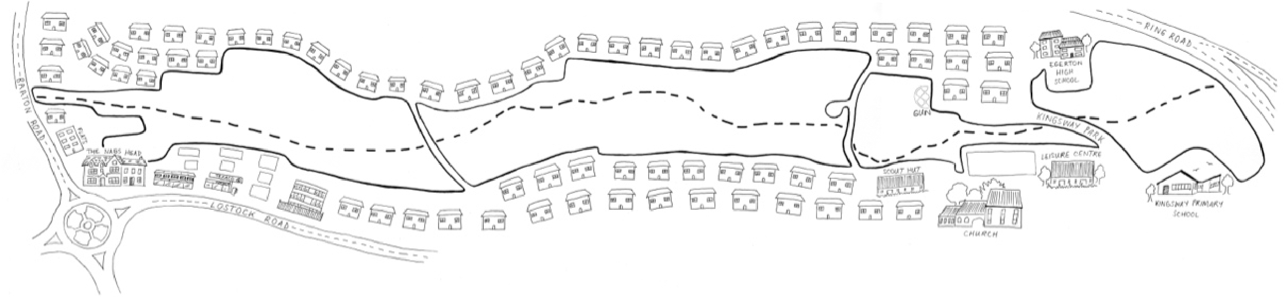
Revisiting Kingsway Park years later after culverting, Baz was astounded by the loss of vibrancy that had once characterized the area, which now lay dormant, as he described it, as a homogenous field of ryegrass. The diverse features, activities and relations that Baz annotated on a map of Kingsway Park late in 2016 (Figure 1), along with a rough tracing of the brook’s course from memory, no longer animated the landscape, testifying to the social and ecological violence of waterway culverting. Erstwhile patterns and dynamics of life, both human and nonhuman, had been curtailed by concrete, fragmented into isolated systems, below and above ground. In the process of completing the map, Baz rekindled his own curiosity and emotional investment in the brook, providing a welcome tonic during a prolonged period of ill-health, and prompted the authors of this paper to take the investigation further. 1 Because certainly, the disappearance of Crofts Bank Brook is not an isolated case of social and ecological erasing, but is representative of the general fate of urban waterways across the world. As rivers and streams were systematically culverted during the 20th-century, communities not only lost touch with their biophysical surroundings, and the environmental flows that sustain urban life, but social relations that had previously bound communities together were also lost.
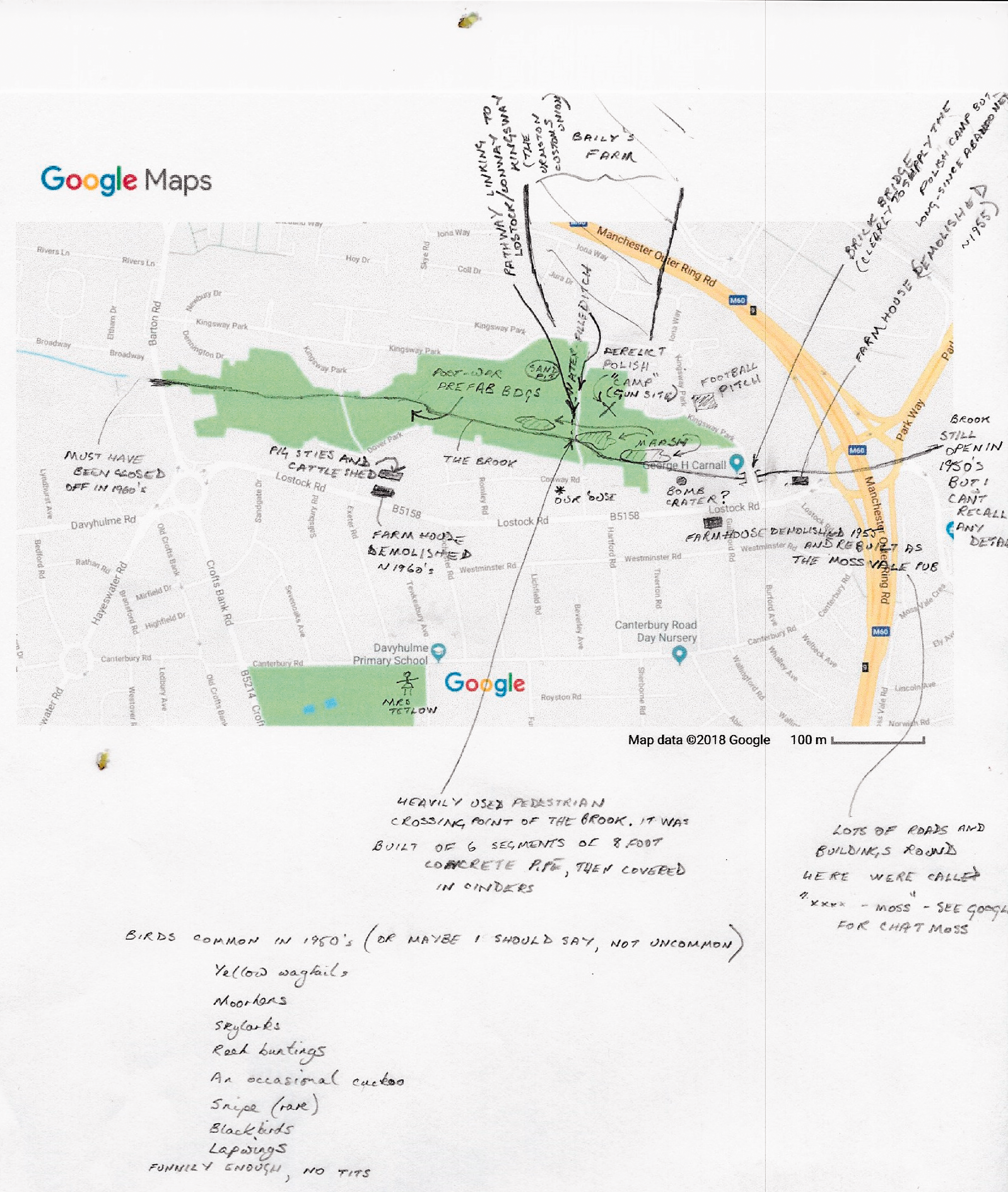
Baz’s annotated map of Kingsway Park and rough tracing of Crofts Bank Brook.
However, as knowledge of the negative consequences of culverting has grown in recent years, buried waterways have started to be uncovered again in a process known as deculverting or ‘daylighting’, 2 with many projects now implemented across Asia, Africa, Europe, America and Australasia (Wild et al., 2011). A global movement has quickly coalesced around daylighting, driven by the success of flagship projects on the Cheonggyecheon Stream, Seoul, and Saw Mill River in Yonkers, New York. Daylighting is a radical form of river restoration that seeks to unlock the potential benefits of hidden urban waterways by returning them to a pre-culverted state, reinstating otherwise compromised hydrological, geomorphological and ecological processes. Whereas traditional restoration entails the renaturalization of banks and beds through removal of hard infrastructure, daylighting involves the exposing of an entirely concealed ecosystem amenity (Baker et al., 2014). The identified benefits of daylighting schemes are multiple and extensive, including improvement of water quality and biodiversity, flood mitigation, reduction in the urban heat island effect, climate change resilience, enhancement of the recreational and aesthetic value of waterways, increasing property values, regeneration and social cohesion (Neale and Moffett, 2016; Smith et al., 2014).
This paper aims to address a number of shortcomings in the daylighting and restoration literature, while underlining the civic potential of daylighting schemes in the current period of declining social infrastructure. First, the paper foregrounds the social benefits of daylighting, particularly community building and sense of place, which has not received the same level of attention as physical and ecological benefits (Smith et al., 2014). Second, as ‘upstream’ engagement remains rare in waterway restoration (Wohl et al., 2015), this paper seeks to demonstrate the efficacy of engaging a community prior to the planning and design of a daylighting scheme, allowing local preferences and concerns to inform project conceptualization, or reject it altogether. The term ‘broach’ is being used in both senses here, as the raising of a potentially contentious issue and the physical release of liquid. Third, the paper challenges the prevalent understanding of community in the restoration literature, which tends to be defined as a pre-existing, cohesive entity that can be straightforwardly engaged. Instead, it is contended here that local residents may not identify strongly with a community, and in fact, through the process of deliberating daylighting, a community can consolidate, through the social nature or ‘stickiness’ (Hodder, 2012: 94) of water.
Drawing on data collected from participatory mapping exercises conducted with professional and community participants, this paper explores the case for daylighting Crofts Bank Brook. The paper compares professional and community perspectives on the potential benefits of daylighting in Kingsway Park, drawing out resonances, differences and tensions. To contextualize the rise and transformative potential of daylighting, the paper will first trace how water has traditionally been managed in the city through centralized hydraulic infrastructure, ‘baking in’ a passive, fragmented water culture, which restorationists are gradually, haltingly ‘baking out’. Using original archival data, the paper will then reveal how and why Crofts Bank Brook was culverted. Subsequently, after outlining the engagement methods, the key insights from the workshops will be discussed around perceptions of wildness, place attachment through water and community as material public.
Crisis of the culvert
Water has endured a long, complex and fraught relationship with the modern city. This relationship is most appositely symbolized by the concrete culvert, channelling water underground, straightjacketing its flow. As social attitudes and scientific knowledge of water have changed over time, so there have been profound shifts in the established approach to its management (Gandy, 2014; Kaika, 2005). In the United Kingdom and other developed countries, the early 19th-century was characterized by inner city deterioration due to rapid industrialization, where waterways became notorious sources of pollution and disease. Water was to be isolated from the urban landscape, with rivers, streams and brooks diverted underground or into enclosed culverts (Kaika and Swyngedouw, 2000): it changed from being an ‘artisanal to an industrial product’ (Bakker, 2003: 42), managed increasingly through large-scale, technological structures and processes. These assumptions about the purpose of water were hardwired into the urban fabric, leaving a ‘modernist legacy’ (Gandy, 2002: 17) of enclosed water networks for future generations. And arguably, the world’s first municipal water system was established in Manchester, connecting the city through a culverted pipe network to the Longdendale reservoirs in 1877, then the largest system of artificial lakes in Europe (Ritvo, 2009).
This gave rise to the ‘hydraulic model’ of the 20th-century, with state-led public water management institutionalized in most western developed countries, characterized by universal monopolistic provision and large-scale engineering (Graham and Marvin, 2001). In the UK, systematic culverting continued more or less unabated until the 1970s, to support broader programmes of urban development, agricultural drainage and flood control (Eden and Tunstall, 2006). An estimated 94% of rivers in the UK had been modified by hard engineering by the end of the 20th-century, being dredged, straightened or culverted (Brookes and Shields, 1996). The hydraulic model has resulted in a condition that has been termed ‘urban stream syndrome’ (Vietz et al., 2015), characterized by significantly altered channels and flow regimes, flashier flood episodes, increased nutrient and pollutant concentrations, lack of vertical, lateral and longitudinal connectivity and reduced instream complexity and biotic activity (Paul and Meyer, 2001). In the most severe cases, waterways have not only been culverted but diverted into combined sewer systems, stretching the elasticity of the meaning of river or stream to breaking point (Broadhead et al., 2015). While there are widely varying local factors leading to urban stream syndrome (Booth et al., 2016), culverting is a common linking cause, a leading ‘fluvial villain’ (Lave, 2012: 23). It will likely take decades, possibly even centuries, to dismantle this hydrophobic edifice, locking in fragmented, damaging patterns of water control.
Over the last 30 years, however, it became apparent that the hydraulic model, predicated on widespread culverting, was beginning to buckle under growing fiscal, technical and ecological pressures. Furthermore, the supply-side, infrastructure-led approach was shown to have detrimental consequences for ecosystems, demonstrated in England and Wales by gradually worsening water quality throughout the 1970s and 1980s (Bakker, 2003). In addition to the negative ecological impacts on aquatic life and wildlife, flooding and erosion started to increase all over the world as a result of decades of channelling and culverting waterways (Karvonen, 2011). The cost of maintaining culverts was also not being met due to public spending cuts, with many reaching their structural use-by date by the end of the 20th-century. Alongside urban stream syndrome, degrading culverts has prompted the uptake of restoration techniques such as daylighting and sustainable drainage. Often overlooked, the implications of this shift are not only technical in character but social and political, revealing the limitations of top-down control while opening up novel possibilities for planning and governance (Cousins, 2018). Across the world, governments have recognized that the culvert crisis is at once an ecological, technological and social crisis (Jones and Macdonald, 2007; Usher, 2018a; Waley and Åberg, 2011), originating in the growing disconnection between water and the city.
Rethinking connectivity
The shift to sustainable drainage, river restoration and daylighting in particular, is reflective of a profound change in attitude towards water, as something that is intricately embedded in society. Increasingly, in both the social and physical sciences, water is being perceived not only as a natural resource but as a ‘social fact’, being ‘integral to many if not most domains or institutions of society’ (Orlove and Caton, 2010: 402). On account of its essential life-giving properties, dynamic physical characteristics and centrality to social, economic and cultural fields, water is ‘promiscuous’ (Linton, 2010: 4) or ‘sticky’ (Hodder, 2012: 94); it has a proclivity to draw and hold together. 3 This makes ‘thinking relationships through water’ (Krause and Strang, 2016: 134) analytically productive, encouraging a holistic, relational sensitivity to the multiple ways that water associates and collectivizes (Watson, 2019). For instance, flooding events inadvertently and temporarily connect previously unrelated elements across public and private spaces, which become disconnected again as waters recede (Donaldson et al., 2013; Krause, 2016; Lane et al., 2013; Walker et al., 2011). Therefore, while water is often thought biochemically standardized, the water cultures that emerge around its flows are complex, unstable and adapted to particular social and physical contexts (Bear and Bull, 2011; Wilson and Inkster, 2018).
However, the hydraulic model of water management, what Sofoulis (2005: 451) terms ‘Big Water’, is not only blind to ‘water’s active role in shaping social life’, but physically ‘bakes in’ a stilted, fragmented water culture. Urban water is often only fleetingly visible as it passes from the domestic tap and toilet into the drain and sewer respectively, where water–citizen interactions are prosaically and prescriptively orchestrated by pipes and plumbing, restricted to particular domestic spaces and forms of interaction. As Big Water is underpinned by ‘hard’ solutions, large infrastructure and structural engineering, the citizen is placed in a relationship of diminished responsibility, alienated from the wider urban water cycle (Bell, 2015). Big Water establishes a ‘hydrosocial contract’ (Hoolohan and Browne, 2019) centred on dependency and ignorance, conceiving the citizen as ‘dumb’ without ‘capacities to act as ethical, inventive and willing partners in innovation for urban sustainability’ (Sofoulis, 2015: 542). In this sense, the urban water system is ‘black-boxed’ (Furlong, 2010: 465), technologically concealed from the people who use it daily, undermining both their awareness and understanding of its dynamics (Chappells et al., 2011; Morales et al., 2014). Infrastructure is physical but it is also profoundly social, lived with intimately and unavoidably (Graham and McFarlane, 2015), mediating the experience and meaning of citizenship in an everyday, mundane register (Anand, 2017; Gearey et al., 2019).
Rivers, streams and brooks have historically stitched social and economic life together, becoming entwined with human culture over time and through landscape, both physically and symbolically. For Laing (2011: 6), ‘[r]ivers run through our civilisations like strings through beads’. However, under the hydraulic model, most waterways, once meandering, have been transformed into standardized, functional channels, often buried underground, becoming detached from ecological and social systems (Kelly et al., 2018). It is not surprising therefore that urban stream syndrome should also have such profound social and psychological impacts. Kondolf and Pinto (2017: 182) have adapted the concept of connectivity, used in ecology and hydrology (Gilvear, 1999; Pringle, 2003), to include social aspects, referring to the ‘communication and movement of people, goods, ideas, and culture along and across rivers’, in addition to matter, energy and organisms. They argue that river straightening, culverting and damming not only undermine the ecological integrity of river systems but their social diversity, leading to a much diminished river culture. Furthermore, cultural dissociation leads to a subsequent loss of ‘cognitive connectivity’ (May, 2006: 478), socially and emotionally divorcing citizens from waterways.
Restoration’s social gap
According to the River Restoration Centre, since the 1990s there has been a huge shift in the management and perception of river systems, and concomitant upsurge of interest in restoration, evidenced by their inventory of 4895 projects in the UK. It was not until the late-1980s that river restoration became widespread as a mainstream practice, taking off in the USA a decade earlier, followed by Japan and Denmark (Adams et al., 2004). Drivers also differ from country to country, with ecosystem improvement prioritized in the UK, fish migration in Japan, flow improvement in Australia, floodplains in the Netherlands and water quality in Central and Eastern Europe (Smith et al., 2014). By far, however, the overriding motivation for restoration schemes has been ecological improvement (Bernhardt and Palmer, 2007; Kondolf et al., 2007). Palmer et al. (2014) analysed 644 restoration projects and found the most common goals to be biodiversity, bank stabilization, habitat improvement and water quality, with social and economic issues being of secondary concern.
In the UK, the policy landscape guiding restoration has also prioritized ecological objectives, resulting in an undeveloped social agenda. The Habitats Directive (92/43/EEC) adopted in 1992 underlined the importance of restoration for preventing biodiversity loss, but it was the Water Framework Directive (WFD), transposed into law in England and Wales in 2003, that marked a ‘clear shift to a more ecological framing of river restoration’ (Palmer et al., 2014: 249). As Wharton and Gilvear (2007) affirm, river restoration has been identified as a vital instrument for meeting the framework’s targets, installing a strongly ecological basis for project planning and implementation (Wehn et al., 2018). Flood prevention has been a second policy objective driving river restoration projects, as they can help realize naturalized catchment processes as specified in the WFD and EU Floods Directive introduced in 2007. For Palmer et al. (2014: 248), a ‘shift toward the more utilitarian view of restoration’ has followed. Therefore, one of the most pressing issues in river restoration is the marginalization of social, economic and cultural factors by ecological and engineering concerns, in both research and project implementation (Baker et al., 2014; Yocom, 2014).
This is possibly because social benefits are less quantifiable than physical benefits such as water quality and flood management (Findlay and Taylor, 2006), although these are clearly interlinked. In terms of research, as Palmer et al. (2014) contend, although there has been growing cooperation between different physical sciences, there remains a deficit of social scientific analysis in river restoration studies. Eden and Tunstall (2006: 676) observe that restoration literature frequently argues for more ‘ecological, geomorphological, and hydrological aspects of restoration…it rarely argues for more social science research to explore people’s views’. In terms of participation, there has been a lack of ‘upstream’ engagement with communities in the conceptualization and planning stage, and where engagement has taken place there has been a dearth of creativity. Restoration projects continue to be dominated by technical experts, at planning, implementation and evaluation stages (Lave, 2012). Consequently, as Moran (2007: 114) contends, the ‘public purpose of stream restoration…has not been discussed in great detail’. Gross (2006: 177) suggests that by including more non-experts in decision-making processes restoration can be made more ‘socially robust’, where ‘scientific and societal activities can be related to each other in order to allow for wider societal influences in the restoration process’. The tide is gradually beginning to turn, however, from a narrowly ecological approach to a more socially-driven agenda (Smardon et al., 2018), while examples of successful ‘upstream’ engagement do certainly exist (McDonald et al., 2004; Moran et al., 2019; Petts, 2007).
Crofts Bank Brook
According to the revised draft of the Greater Manchester Spatial Framework, ‘very few water bodies’ (GMCA, 2019: 84) reach the required standard of the WFD, necessitating urgent remedial action. The highest contamination levels of microplastics recorded anywhere in the world were in Greater Manchester’s river network (Hurley et al., 2018). The central rivers, part of the Irwell catchment and provisioning around two million people, have received the most attention for improvement, all having undergone or been slated for restoration schemes. Crofts Bank Brook, located approximately 6 kilometres south-west of the city centre in the metropolitan borough of Trafford, is a less well-known waterway, being more peripheral, slower-flowing and smaller, but has experienced a similar fate. It flows west from Chorlton-Cum-Hardy, via Kingsway Park, into the Manchester Ship Canal, for approximately eight kilometres, changing in name from Longford Brook, to Crofts Bank Brook, through to Bent Lanes Brook. These alternative designations are indicative of the areas through which it flows, where the brook assumes the name of the places it used to visibly dissect. It is now largely culverted, emerging as an open brook 500 metres before it enters the Ship Canal, from beneath a private garden. This paper is focused on a section that runs underground through Kingsway Park, a playing field of approximately 15 hectares, which is bordered by concentrated housing to its north and south, a main road to the west, and two schools, a leisure centre, a Scout hut and church to the east. Kingsway Park is categorized as ‘local’ given its relatively limited recreational significance and residential catchment. It includes a play area, zip wire, football pitch and some landscaping features. Development has not been possible on the site as the park was formerly landfill, protecting it from encroachment as the area rapidly urbanized during the 20th-century.
Until it was culverted in 1965, Crofts Bank Brook divided Kingsway Park into two separate sections, north and south, running more or less along the middle of its length (Figure 2). The brook enters the park from the east and meanders sharply northwards, curving gradually south before it leaves the park under Barton Road Bridge. It can be seen from old maps and aerial photographs that the brook had a distinctive shape before culverting, which had not been significantly altered since at least 1836, influencing the layout of the surrounding housing estates. Although the brook had a width of around three metres, the adjacent land was marshy and its banks rose steeply in places, making it a prominent feature. Indeed, it provided a reliable visual anchor as the area surrounding it experienced radical, irreversible change. From the Nag’s Head pub, Kingsway Park would have looked much like a typical countryside setting in 1930, with the brook winding through bounded fields and past scattered cottages. However, during the 1930s, rapid suburbanization began with rows of housing appearing along Lostock Road and the first sections of Kingsway Estate constructed in 1935. By the early 1960s, however, with the extension of the Kingsway Estate and Dover Park, Crofts Bank Brook was hemmed in from all directions, and forced beneath the Manchester Ring Road, laid in the late-1950s.
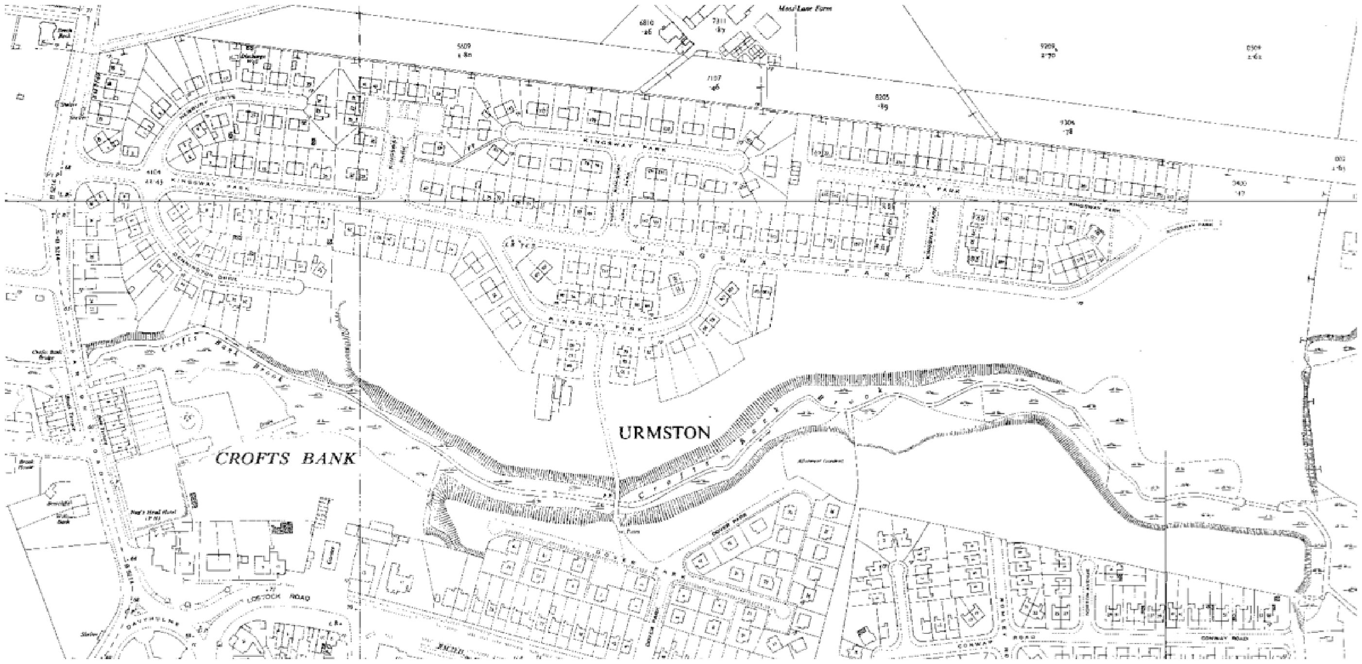
Historic map of the study area, showing brook before culverting. © Crown Copyright and Landmark Information Group Limited 2019. All rights reserved.
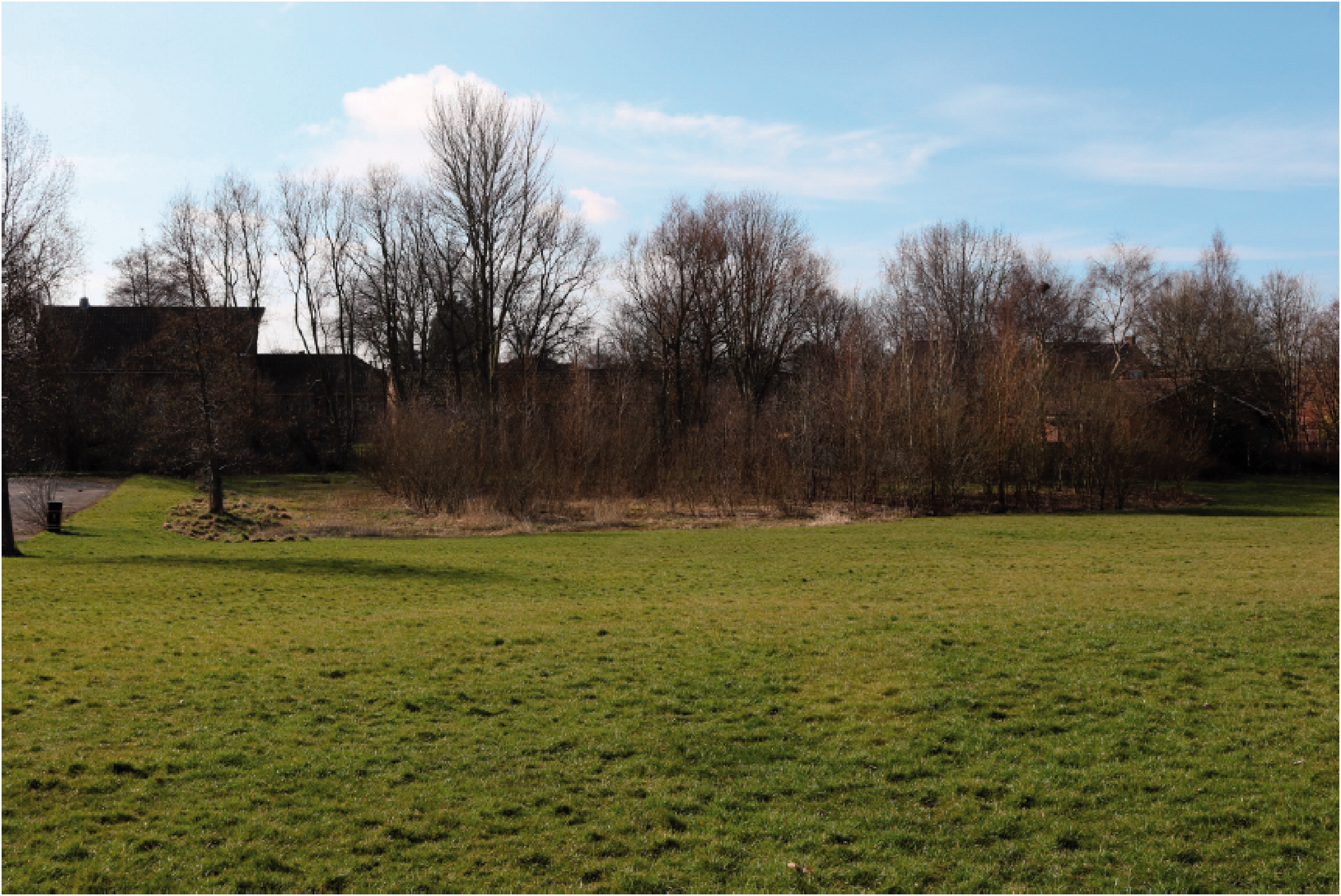
With urban development creeping ever closer to the brook, culverting occurred in 1965 at the behest of the Urban District Council of Urmston, the final phase of a three-stage culverting process. The culverting process took five months to complete, with a budget of £40,000, with 10% set aside for landscaping. While the private contractor was asked to maintain the ‘natural flow of the brook’, the circular pipe culvert, 60 inches in diameter and located between one and two metres below the surface, followed its previous course but straightened it drastically, particularly at the east end. A meandering brook had been transformed into a zigzagging geometric pipeline and buried underground. The rationale for culverting appears to be recreational repurposing, with football pitches being prioritized, although it was likely also driven by aesthetic preferences and health concerns. Land use characteristics have not changed significantly since culverting, and aside from a line of ten manhole covers and moderate subsidence and water pooling, there is little indication that Crofts Bank Brook still flows under Kingsway Park (Figure 3). It appears technically realistic that the brook could be restored to a more natural course profile, however, the aim of this paper is to explore local practitioner and residents’ opinion on whether restoration would be socially desirable and viable. There are no existing or future plans to daylight Crofts Bank Brook.
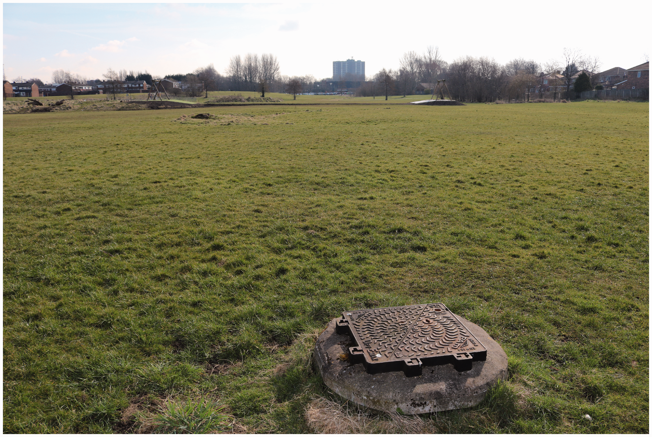
Kingsway Park with manhole cover in foreground and zip wire in background.
Engagement methods
To elicit views on daylighting we undertook three workshops: one in March 2018 with 10 professionals based in Greater Manchester, and two in August 2018 with approximately 30 community residents overall. The workshop aimed at professionals comprised an individually invited group based on expertise and remit. Recruitment for the community workshop was undertaken by delivering leaflets to each residence in the immediate vicinity of Kingsway Park. Online forums were also targeted. There was no filtering of participants, to optimize the sample for instance, as this would have been inappropriate given that workshop activities occurred in publically accessible community locations. Professional and community workshops were based around a collaborative participatory mapping exercise, in which participants were asked to annotate large (A0) maps. This ‘manual’, as opposed to digital, approach was selected first to promote usability with respect to community members who might be less familiar with digital interfaces, and second, to promote collaboration (Dunn, 2007). Gathering around a large paper map in a group can facilitate discussion in a way that would not be possible using conventional laptops or tablets, where only one participant at a time can input data. In addition, affording participants the ‘artistic freedom’ to draw and write on the map permits them the agency to translate their thoughts and feelings onto the map without the necessary restrictions imposed by typical digital interfaces (Evans and Waters, 2007; Huck et al., 2014, 2019). This freedom afforded by ‘manual’ mapping exercises also means that the outputs permit a more deep and qualitative analysis than most digital alternatives.
In the case of the professional workshop, we provided participants with a pair of maps produced using GIS software based upon data from OpenStreetMap (https://www.openstreetmap.org). One covered all of Greater Manchester, to facilitate a general discussion of daylighting benefits, and another covered Kingsway Park, including the approximate route of Crofts Bank Brook (Figure 4). The maps were designed to be sufficiently detailed to permit ease of navigation but without making it difficult to illustrate. Participants were divided into three groups according to professional background, including water management, landscape design and environmental conservation, and asked to design their ideal daylighting project, discuss ‘real world’ challenges, and how these might be overcome. Participants in the community workshops were not engineered into groups but formed their own with people they knew or had grown familiar. Participants in this workshop were provided hand-drawn maps to promote creativity and to attempt to reduce potential concerns about the accuracy of the information that participants were adding. The number of houses drawn around the edge, for example, is purely illustrative, whereas the shape of the field and points of interest (e.g. Scout hut, WWII gun emplacement and pub) are all broadly correct. In this case, both of the maps were of Kingsway Park and the immediate vicinity, with one showing the park as it is now, and one including the original course of the brook as a dotted line (Figure 5). On the first map, participants annotated how the park was currently used, on the second how the park could function with daylighting.
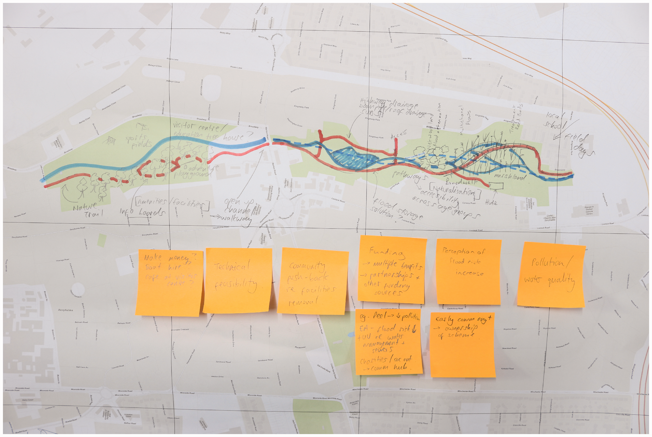
Notes applied to Kingsway Park map in the professional workshop.
Community workshop sketch map including the approximate original course of the brook.
Prior to sketch mapping, participants in the community workshop were taken for a ‘walk and talk’ activity along the original course of Crofts Bank Brook, which was plotted using historical maps and a GPS receiver, and marked out using blue helium-filled balloons tethered at 50 m intervals. This was intended to help participants to visualize what the brook might have been like prior to being culverted, to reflect upon the positive and negative impacts of culverting, and to provoke discussion. Facilitators handed out historical maps of the park from the 19-th and 20-th centuries and engaged the participants in group discussions relating to their memories of the brook, the ways in which the park is used now, and how it might be different if the brook was reinstated. Data from the workshops were visually interpreted with key themes drawn out and analysed, in terms of perceptions of wildness, place attachment through water and community experience.
Discussion
Everyday wildness
There was a marked difference of perspective between the professional and community groups on the potential design and benefits of daylighting Crofts Bank Brook. All three groups in the professional workshop, divided according to expertise, identified ‘health and wellbeing’, both ‘physical and mental’, as a main potential benefit, alongside biodiversity, water quality and quantity, economic growth and community. To address the ‘lack of green space’ in Greater Manchester, it was suggested that naturalistic features could be introduced to Kingsway Park as part of a daylighting project, to facilitate the ‘diversification of the green desert’. The most popular suggestions were tree planting to create woodland areas and the creation of a lake or pond, followed by the remeandering of the daylighted brook. Wetlands, marshlands, reed beds and flower patches were also proposed, to facilitate the ‘naturalization’ of Kingsway Park. Resident interaction was identified as a key priority in the professional workshop, enabled through ‘natural play areas’, information boards, stepping stones and bridges across the brook, allotment plots and a dipping platform.
The suspected benefits for the community reflected the broader policy agenda, being largely oriented towards ‘educational learning’ and ‘health and wellbeing’. Given an unlimited budget, proposals were tabled for embedded amenities such as a cafe, art gallery, visitor centre, cycleways, boat hire, Parkrun routes, bird hide and even an ‘education treehouse’. The landscape design group put the most emphasis on community engagement and waterway culture, to restore social and cognitive connectivity, through ‘glow in the dark’ woodland routes, augmented reality trails, and ‘citizen science’ projects led by the local school and Scout group. However, while there was recognition that ‘environmental constraints’ associated with daylighting were relatively manageable compared to other sites, ‘public health and safety’ was identified as the most likely local concern that would undermine viability, particularly around flood risk perception and water quality. Community engagement was therefore deemed essential by professional actors, alongside a ‘cross department approach’ including planners, Environment Agency and water authority representatives, NHS health specialists and green space managers. Possible funding, maintenance and land ownership barriers could be overcome by early ‘buy-in’ from community and multiple sector professionals.
There were certainly analogous suggestions from local residents, with tree planting and pond construction being the most popular, encouraging ‘willows to drink the water’. A young child drew a clump of trees on the map in proximity to where she had marked ‘grandad’s’ house. Other proposed design features included a vegetable patch, play area, rope swing, ‘logs for playing on’, stepping stones, interactive dams and a ‘dedicated area’ for Scouts and Guides, to facilitate ‘outdoor lessons’. As with the professional response, the potential for incorporating the daylighted brook into the local school’s activities, for educational and even maintenance purposes, was identified as a priority. Except for one sketch map, there was no general ‘shopping list’ of benefits as had been adopted by professionals, citing health, education, biodiversity and so on, where instead local context was more determinative. For instance, Keith 4 believed that daylighting could provide grounds for contesting plans to close the local leisure centre and build a new sports stadium and residential block, by revealing existing but concealed environmental assets. One resident simply wrote, with a sense of incredulity, ‘why was the stream covered over in the first instance?’
However, departing from the professionals’ focus on health and wellbeing and educational learning through managed community access to natural features, local residents’ response tended to be more emotionally grounded in a longing for ‘wild’, untamed elements. Design suggestions included ‘wildlife’, ‘wildflowers’ and a ‘wild bank’ that could be left ‘not too managed’. As one resident proclaimed, ‘[I] would love to see a running brook’. Colin, one prominent community member heavily involved in youth activities, recalled how he used to canoe through wet woodland found in Kingsway Park during his childhood in the 1960s before it disappeared, providing a sense of adventure that he believed was currently lacking (Figure 6). Whereas previously Kingsway Park used to regularly flood and retain water, changing its atmosphere and appearance, according to Colin, the water table appears to have dropped. This has deprived the park of its wilder, unpredictable side, which he believed had enriched his childhood, as Baz had also claimed in respect to his own experience interacting with wildlife and vegetation flourishing in and around the brook, subsequently removed with culverting. Colin strongly supported the idea of daylighting for this reason: ‘anything that takes the blandness out of it … I want to give kids the experience we had’. Another resident underlined the importance of having ‘both managed and unmanaged parts’, which ‘if left wild and not deep’ could ‘encourage play’.
Woodland where Colin canoed as a child in the 1960s before the area lost standing water.
Nevertheless, there was some concern from local residents that deculverting Crofts Bank Brook could introduce new risks, such as ‘danger to children playing out near an open brook’, a common anxiety associated with restoration (Eden and Tunstall, 2006; Tunstall et al., 2000), while also exacerbating existing problems. Those living on adjacent streets, such as Conway Road, were worried that open water might increase the local rat population and provide a breeding ground for ‘mosquitoes and flies’, becoming ‘smelly in hot weather’. Other residents suggested ‘people will throw litter in the water’ if the brook appears too naturalistic, appearing unkempt and disregarded, which reflects findings from previous studies that confirm residents prefer cosmetic, formal, even railed waterways (Adams et al., 2004; Prior, 2016; Tapsell, 1995). The most raised and contentious concern was the possibility of increased flooding, which residents suggested should be addressed before daylighting goes ahead. According to older residents, while the brook used to flood before culverting, the consequences were more predictable and manageable. A regularly mentioned flooding episode in 2012 led to a manhole cover blowing off the culvert, creating pooling that Colin likened to ‘Lake Geneva’. Sewage pipes were affected and excrement entered some residents’ homes located off Kingsway Park. Alan, who had experienced this first-hand, became agitated and confrontational in the workshop when the case for daylighting was made, revealing a deep, prevailing suspicion within the community concerning the subterranean water network.
Seemingly, the culvert is staunching not only water flow but deliberation of its dynamics and potential relation to the landscape, creating an absence which in turn breeds mistrust. Yet, through the process of engaging the community, rendering the brook temporarily visible in the minds of residents, the ambivalent tension between its desirable and disagreeable tendencies has been recognized, providing a basis upon which to discuss its function, appearance and character. Geoff, who has lived by Kingsway Park for over 60 years, was initially highly negative about the brook, which he remembered as being slow-flowing, smelly and ugly. However, after five minutes of reminiscing, Geoff began to change his opinion, reconsidering its value. When the contractors arrived to culvert the brook in 1965, Geoff recalled, his then young children threw debris at the earth-moving vehicles to drive them away, as they used to fish for stickleback in its waters. The brook had been an important part of their childhood, a valued feature of the community, which Geoff had forgotten in subsequent years after culverting. Another resident recounted a similar memory in response to a workshop invitation posted on a community Facebook group, replying ‘that little brook ran under our house on thirlmere ave [and] I use to spend hours catching sticklebacks and waterboatmen beetles, loved that brook’. Another reply revealed a similar level of animosity and despair at the loss of wildness to that recounted by Geoff, suggesting a difficult shift for the contractors: I remember the brook, my friends and I used to catch tadpoles in it…we used to walk by the brook on the way to school looking for wildlife. I remember when they closed it off, my brother who would have been 10-12 staged a protest and smashed the windows on the bulldozers and then threw stones at the drivers and verbally let them know they were killing lots of animals and ruining the place.
Currently, residents’ interactions with the brook are limited to moments of rupture and crisis, when the culvert malfunctions in the form of bursting manholes, leaking sewage, subsidence and pooling. By broaching the brook, assumptions about how water is supposed to reside in the city can be considered, renewed or challenged. After two hours of conversation with local residents and workshop facilitators, Alan became significantly less confrontational as the possibility that daylighting can reduce flooding was discussed, and familiarity grew amongst participants. It became apparent that wildness was less a question of aesthetics (e.g. informal, rough) but a matter of how nature acts unpredictably, and how it can be accommodated, even welcomed, within the urban context (Jorgensen and Keenan, 2012). During the ‘walk and talk’, Sally hesitantly interjected to share her memories of playing in Crofts Bank Brook as a child in Lostock Park, where culverting has also occurred. Sally enthusiastically recounted the occasions when she or a friend fell into the water, much to the consternation of their parents, prompting a lively discussion amongst the group about the current lack of opportunities for children to get dirty and wet. Participants who had not lived in the area or were too young responded with delight that Sally could have paddled in a waterway so close to home. The contention here is that water, once released from its culvert, can inject vibrancy into the park and provide a sticky medium for new relations between residents and their surroundings, to foster acceptance, even admiration, of the brook’s unpredictability and wildness, ‘decentring homo urbanis’ (Steele et al., 2019: 1).
From passage to place
The social stickiness of water was recognized by some local residents as a property that could potentially attract visitors to Kingsway Park, adding to the vibrancy and legibility of the area, which, according to them, is currently lacking. A common grievance in the community workshops was the ways in which Kingsway Park is currently used, or not used, leading to a space devoid of vitality. William suggested that the park was ‘underused’ as a community asset due to it often being ‘too wet to play on’. This is perhaps why the football pitch is ‘rarely used’, which requires a flat, stable playing surface. No members of the research team witnessed it being used during the workshop sessions or while making prior visits. The underuse of Kingsway Park does not seem to be for lack of amenities either, with a good quality playground area, zip wire and football pitch being available for recreational purposes. On walking through Kingsway Park, there is limited variation in the landscape and very little visible wildlife, although some landscaping was completed a decade ago, introducing vegetation mounds to break up the ryegrass field. There are sporadic clusters of old and young trees, providing welcome relief. A memorial to a World War II anti-aircraft gun emplacement also adds topographical variety, although this is positioned on the northeastern fringe of the park and is not accompanied by any signage. Nevertheless, the park is mainly used by dog walkers, an important function certainly, and by residents from the adjacent housing estate seeking access to bus stops, cafes and shops on the other side of Kingsway Park.
It can be deduced from responses that, aside from instances of waterlogging, which is common along the culvert course (Figure 7), temporarily revealing its existence, the underuse of the park can be attributed to both anti-social uses and its transient character. In the first case, Rob suggested the ‘park is utilized but in all the wrong ways’. This reflected a broader opinion that for a park of this size, location and significance, it was not used, as are similar parks in the region, for walks and resting. The most common anti-social element identified was the prevalence of ‘dog poo’, making parents feel uncomfortable about allowing their children to play there, which Colin also revealed impacted detrimentally on Scouts’ field games. However, other, more intimidating forms were identified such as ‘kids with cars’, teenagers drinking in the playground area and people playing golf. Significantly, residents were liable to connect anti-social elements to the transient character of Kingsway Park, which, according to residents, has been a longstanding problem. The community sketch maps provided evidence of Kingsway Park functioning as a ‘passage’, as Rob described it, with lines drawn across the field, accompanied by descriptors such as ‘path to bus stop’, ‘walking to and from school’, ‘cycling to work’ and ‘used as shortcut from housing during short lived dry weather’. As William implied, this latter comment does indicate a connection between waterlogging and park underuse.
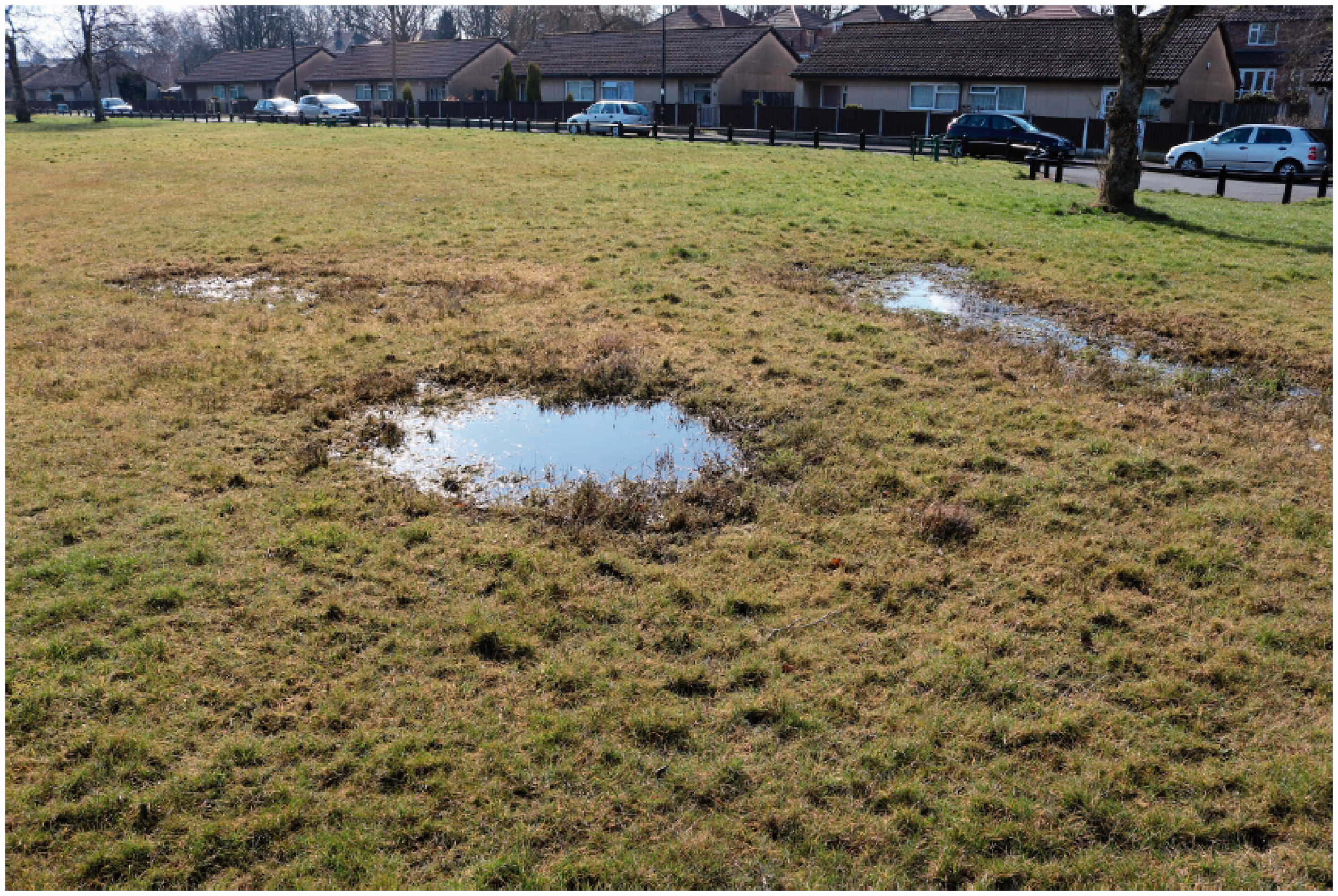
Subsidence and waterlogging along the brook’s course.
Therefore, aside from ‘prolific dog walking’, as highlighted by one map, the park is not perceived as a place to spend quality time for the majority of residents; rather, it is seen as something to pass through to reach other destinations (Figure 8). Furthermore, the absence of regular visitors leaves it open to uses that reduce its attractiveness, leading to even fewer lingering people. Essentially, what these different responses from the community workshop indicate is a lack of ownership and stewardship over the park, which, being centrally located within a ring of housing, is having wider impacts on community life. While residents acknowledged the benefits of having a relatively pleasant, traffic-free route to their daily destinations, daylighting Crofts Bank Brook could actually encourage people to visit the park for its own sake, inspiring them to linger and engage in more diverse activities. This is what Rob called the potential ‘sheep effect’ of daylighting, where increased vibrancy could draw in even more visitors, transforming Kingsway Park from a passage to place, exploiting the stickiness of water.
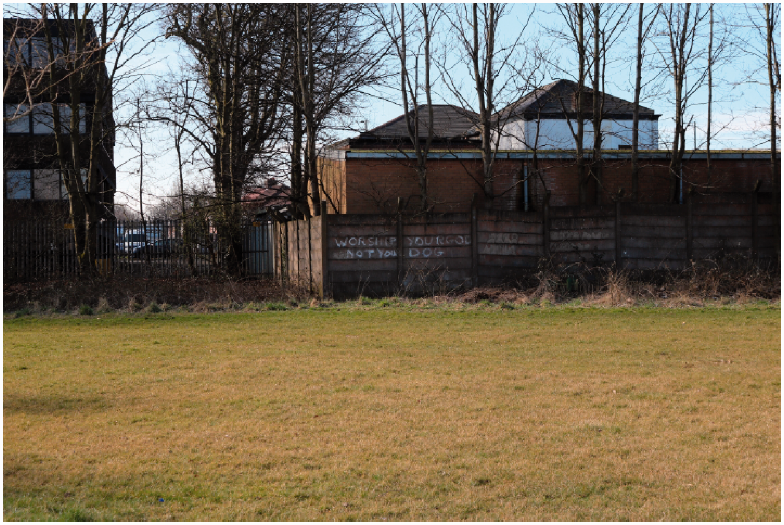
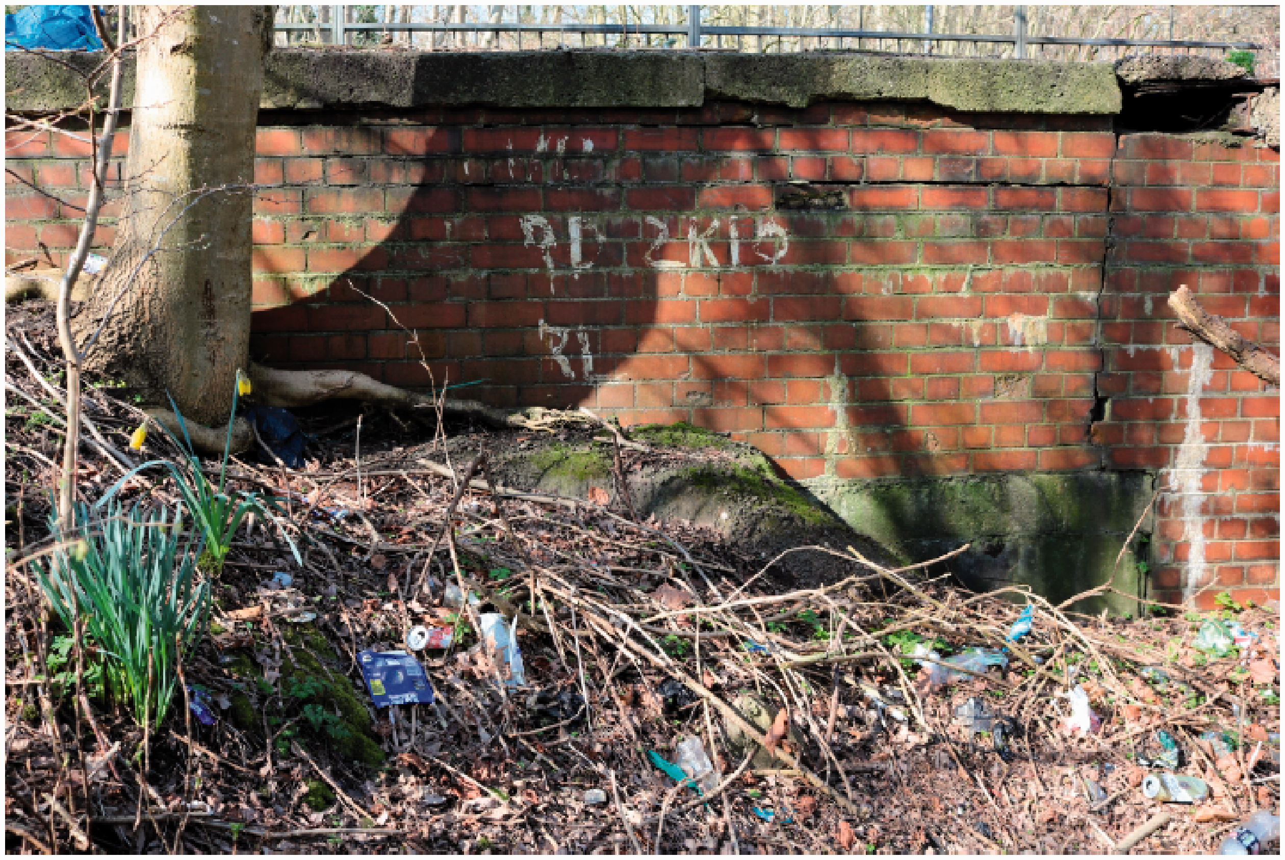
Graffiti urging visitors to ‘WORSHIP YOUR GOD NOT YOUR DOG’. The brook would have been visible in the foreground.
Water, as research has evidenced, does encourage social interaction between visitors (de Bell et al., 2017), while place attachment often acts as a precursor to community stewardship (Kelly, 2018; Smith et al., 2014). In their post-restoration survey of the River Skerne, Åberg and Tapsell (2013) found that residents not only visited the waterway more frequently but it had encouraged place attachment, where affection for the waterway increased as the vegetation matured and wildlife returned. In daylighting designs for Kingsway Park, residents included features that would attract and retain visitors, such as a ‘community vegetable patch’ and even a ‘wifi station’ for younger people, who might subsequently join in other activities. Existing organizations could also base their operations in and around the brook, becoming increasingly rooted in the landscape. High school students would become more protective over the park if biology lessons were conducted there, as ‘currently they go to Davyhulme Millennium Nature Reserve’. Similarly, a ‘Scout system could work on different levels passing on knowledge, from Beavers to Cubs to Scouts’ and could ‘help manage or create’ naturalistic features, fostering ownership in the process. Time spent in naturalistic spaces and awareness of biodiversity conservation are positively related to acceptance of wilder, less manicured urban green spaces (Fischer et al., 2020), suggesting a positive feedback loop could emerge from outdoor lessons in local restored landscapes.
Participants also identified benefits that could result from a more vibrant park, which in some cases contradicted the professional perspective. As previous studies on restoration have revealed (Åberg and Tapsell, 2013; Eden and Tunstall, 2006; Moran et al., 2019), residents tended to put greater value on mundane interventions such as footpaths and benches, as opposed to nature trails and augmented reality, for enhancing quality of place. More specifically, while professionals predicted that an open brook would prompt health and safety concerns from residents, Rosie actually suggested that daylighting would reassure parents, making the park feel busier and safer. Rosie and her partner are hesitant to allow their children to play independently for fear of older children but suggested that they would be inclined to allow this in a more vibrant, populated setting. Another identified benefit of the brook would be enhanced legibility and orientation. The sketch maps indicate the football pitch and playground area currently serve as local orientation markers, but these features are not strongly integrated into residents’ routines. As two participants who had recently moved to the area disclosed, looking at historical maps that included the open brook had provided a missing focal point. In the evening workshop, Sarah and Lisa began to debate whether Kingsway Park was in Davyhulme or Urmston, and whether this was important, on account of where the brook passed through, inciting reflection on place. Rosie had conducted desktop research into the brook when she realized a couple of years ago that it passes near her garden, driven by her curiosity of how the brook connected her home to other places.
Understandably, tensions became apparent while participants were discussing their place attachment to Kingsway Park, and the potential effects of a daylighted brook. There were differences of opinion regarding how a park should be used, and what should be considered anti-social. Rosie deemed it anti-social to play golf on the field, while participants in the evening workshop actually professed to engaging in this activity themselves, identifying it as a key benefit. Similarly, in the afternoon workshop Rob spoke of the ‘sheep effect’, drawing in a higher volume of visitors, while residents in the later workshop expressed concern that Kingsway Park might be overrun by outsiders. From the facilitators’ perspective, there was also tension between prioritizing resident opinions and preferences while avoiding becoming entangled in local disputes, around the leisure centre closure for example, which can ignore or negate broader social and ecological goals (Smith et al., 2014; Tunstall et al., 2000). Indeed, ecologically speaking, green space functioning as a transient passage might actually benefit some insects and animals more than a bustling, recreational place. However, as there are tensions associated with how water interacts with the city, unpredictably and sometimes dangerously, which can be more damaging if contained and concealed, the same could be ventured for discussion of place. To broach water is also to broach concerns that may otherwise have lain dormant, around the sharing of public space, the relation of places to their surroundings, and the strength of community.
Community as material public
The most surprising and provocative finding that emerged from the workshops related to the notion of community, and how it has been understood, or perhaps misunderstood, in restoration engagement methods. When the aims of this project were being formulated, it was established that community perspectives would take precedence over that of professionals, at least analytically, in order to explore the importance of upstream engagement in restoration and daylighting design. The intention was to first elicit the opinions of professionals that could be involved in daylighting Crofts Bank Brook, water managers, landscape designers and conservation experts, followed by and compared with the community perspective, to reveal similarities and tensions between them. During the professional workshop, the importance of involving the community in the design process was emphasized repeatedly, while ‘the community’ was identified as a key beneficiary of daylighting in the sketch map exercise. Throughout, community was used as shorthand by all three groups at the professional workshop to refer to local residents living around Kingsway Park, and civil groups such as the Scout group and church congregation, presumably as this makes the task of envisaging and practicing engagement more realistic and routine.
However, as the engagement process unfolded over subsequent months, it became clear that a community did not exist in a singular, static sense, as a cohesive entity that could be straightforwardly enrolled into the project. The evening workshop was consistently disrupted by Alan (to the obvious and vocal dismay of other participants) who accused one workshop facilitator of being a ‘salesman’ from the water authority. While other participants quietly sought to reassure the facilitator that the majority of those present welcomed the opportunity to consider daylighting the brook, it was clear that resentment and impatience was growing, and the room gradually fractured into small groups. Two participants revealed that they had actually hidden their identity to avoid being identified by other residents, for reasons that were not entirely clear. A local businessman, who did not participate but struck up conversation during preparation of the evening workshop, questioned the motive behind the project, describing the facilitators as ‘brave’, implying naivety, for attempting to engage the community. Indeed, some local residents participating in the workshops disputed the assumption that a community existed in and around Kingsway Park at all, with one insisting ‘there isn’t a community here’. These residents were under the impression that neighbours did not regularly interact with one another, a situation that they suggested would become more entrenched with closure of local amenities such as the leisure centre. This viewpoint certainly tallies with the current underuse of Kingsway Park that was widely reported by participants, revealing not only the park’s lack of integration with local residents’ everyday routines but its failure to perform as a public realm.
Against this discouraging background, however, what also became evident was that interpersonal relations between residents began to crystallize in and through the engagement process itself, if not spontaneously then certainly reactively to the proposal for daylighting. This was unexpected but soon became a central focus for understanding the less acknowledged and theorized social benefits of daylighting for communities that are constantly forming, adjusting and evolving in response to matters of connective concern. Before any resident had been contacted face-to-face, and over a month before the workshops took place, Colin, as a prominent community figure, had already drawn on his embedded networks to elicit interest on the prospect of daylighting. Colin had been contacted a month earlier by email before distribution of flyers and confirmed a broad level of interest amongst those with whom he had spoken when visited by the project team. Indeed, some workshop participants had not received a flyer but had been persuaded by Colin to attend, including his elderly parents who did not otherwise regularly visit the park. Colin had also shared the project aims with the children he was involved with at a community level, suggesting that he may create an activity based on the hidden brook and the notion of daylighting.
In the evening workshop, it transpired that some participants had contacted their neighbours to invite them to attend, as they had shared experiences of flooding or childhood memories of playing in the brook. Chloe explained that she had been compelled to knock on her neighbour’s door, with whom she ordinarily did not interact, on account of their shared distrust of the underground water network and water authority. The ‘walk and talk’ had also brought residents together, who bonded over the sharing of stories from childhood. David, who had moved to the area only three years previous, professed to having gained a new perspective on Kingsway Park, through the memories of other residents, igniting synapses in the local collective conscience. There were instances where the engagement process brought people back into contact who had not spoken for an extended period of time. Beryl responded to the Facebook invitation by stating her support for the project: ‘I lived near the bridge over the brook on Barton road. Many happy times spent searching for tiddlers until it was culverted. The idea of uncovering the brook sounds a good one to me’ (Figure 9). In reply to this message, Sandra exclaimed ‘[Beryl] how the devil are you!!!!xxxx’. This demonstrates that community is something that continually reasserts itself in response to specific issues, as an ongoing process of responding collectively to new circumstances, rather than existing in the abstract as an entity that can be readily engaged.
The brook passes under Barton Road Bridge and exits Kingsway Park to the west. Before culverting, this would have been a bridge over free-flowing water.
This understanding of community, as a ‘material public’ (Marres and Lezaun, 2011) that emerges and consolidates reactively around concrete issues, has significant implications for how engagement is carried out and what forms of participation are adopted in environmental planning and design (Chilvers and Kearnes, 2016). As Eden (2017: 8) affirms, ‘environmental publics are differentiated through their practices of environmental engagement, rather than through their sociodemographics’; they organize temporarily, conditionally and relationally through deliberative engagement with a specific material problem, from pipelines and flooding to smart grids and geoengineering (Barry, 2013; Bellamy and Lezaun, 2017; Donaldson et al., 2013; Throndsen and Ryghaug, 2015). Certainly, an emerging material public could be detected in relation to the idea of daylighting Crofts Bank Brook, which brought previously unacquainted residents into relation over a common interest, revealing the importance of inclusive and effective participation. Therefore, it is not surprising that where participation methods failed, residents felt betrayed and disenfranchized by not being included in the deliberation of daylighting, as this was effectively drawing the boundaries of an emergent community of interest.
This partly explained Alan’s confrontational behaviour, who regrettably did not receive an invitation flyer due to an oversight in distribution. This sense of exclusion from the community was then heightened when Alan realized his house was not depicted in the sketch maps, which were drawn in a simplistic, cartoonish style and were not intended to be an accurate cartographic portrayal. Most problematically, a misunderstanding in regard to the starting point of the evening workshop meant that approximately one third of participants did not partake in the ‘walk and talk’, missing the project introduction and landscape history of Kingsway Park, including the culverting process, as a consequence. One member of the research team, stationed at the workshop location during the ‘walk and talk’, provided an overview of the project to those participants arriving early, while an abbreviated landscape history was delivered again to the whole group. Nevertheless, the participants that attended the ‘walk and talk’ gained a more contextualized understanding of the project aims, which had been linked to the physical landscape, anchoring the discussion in tangible, familiar terrain. This left some participants who had missed out frustrated and drained before the sketch map exercise began, a situation the research team sought to mitigate by circulating around smaller groups to clarify details and respond to any questions or concerns. Although this prevented the workshop running as smoothly as it may have otherwise, this initial mix-up did highlight the collectivizing potential of interventions such as daylighting, as the workshop ended very amicably once all the participants, especially Alan, had been engaged individually. Small group discussions over maps were largely positive, revealing a good level of interest and local knowledge. Facilitators and residents remained in the pub afterwards over drinks and snacks, conversing more informally about the brook. Sarah cheerfully showed one facilitator her property deed that revealed the brook actually ran under her home, as it did one of the facilitator’s houses over three kilometres away, connecting them subterraneously, hydrologically. It is this physical–ecological rather than abstract–representational form of publicness that waterways encourage, revealing a shared connectedness and rootedness in and through landscape.
Wilding the city, or experiments in complex coexistence
There is a growing academic, media and policy focus on the benefits of blue infrastructure. Yet, while evidence has grown on the enabling and restorative qualities of water in urban environments (Foley and Kistemann, 2015; Garrett et al., 2019; Gascon et al., 2017; Pitt, 2018; White et al., 2010), there remains a lack of in-depth, qualitative understanding of its social benefits (de Bell et al., 2017). Furthermore, the proposed benefits of blue space have tended to be narrowly defined around wellbeing and learning, measured on an individual, cognitive level (see Kelly, 2018; Vert et al., 2019). This, as Bell et al. (2019) caution, is linked to a reductionist tendency in nature benefits research, reinforced by the natural capital agenda, which medicalizes, individualizes and instrumentalizes humans’ relationship with the environment. Indeed, what has largely been missing from research on blue space benefits is the collectivizing potential of urban water, and how it can potentially bring communities together through its stickiness, which occurs at ‘meso-levels’ between the individual and population, ‘where the social happens’ (Sofoulis, 2015: 543). While the connective capacity of water has radically diminished under the hydraulic model, water networks can provide leverage for widespread socio-technical change given their deep embeddedness in everyday life (Farrelly and Brown, 2011). Minor tweaks or wholesale shifts in infrastructure, which sustain, shape and normalize everyday life, can encourage alternative, more convivial ways of dwelling, precipitating new forms of public life.
This, as Amin and Thrift (2017: 6) describe, is a ‘politics of small interventions with large effects, a politics of locating pinch points…infrastructural tuning and adjustment’, or, as Simone and Pieterse (2017: 155) prefer, ‘a cumulative, slow-brew politics’, ‘acupunctural’ rather than ‘systemic’. Under the hydraulic model, opportunities for encountering urban water are few, prescribed and heavily mediated by infrastructure, delimiting how water can be experienced in an everyday context. Daylighting, as a radical form of river restoration, has huge potential for introducing alternative modes of urban existence, as this paper shows, in residents’ relations to nature, the character of place, and experience of community. Daylighting restores ecosystems but can also create new socio-ecological relations, ‘unblackboxing’ the ‘deep taken-for-grantedness and invisibility’ (Graham and Thrift, 2007: 8) of infrastructural systems, challenging their latent normativity and possibilities for action.
What we term ‘everyday wildness’ should not be conceived as an oxymoron, where a desire for dynamic, wilder spaces was evident in the responses of Kingsway Park residents. This resonates with the agenda of the rewilding movement, which has provoked significant, often heated debate in respect to the growing plasticity of the term (Jørgensen, 2015; Nogues-Bravo et al., 2016). The classic interpretation of rewilding focuses on the introduction of keystone species to restore trophic complexity, however its application has broadened to encompass ‘ecological rewilding’, allowing natural processes to regain dominance in a landscape (Corlett, 2016). Rewilding has therefore come to denote a process through which complexity, vitality and unpredictability are reinstated in landscapes through the rolling back of intensive management regimes, to precipitate more open-ended ecosystem dynamics, rhythms and effects (Fernández et al., 2017; Perino et al., 2019). This shift in scope has prompted critics to question the novelty of rewilding vis-à-vis traditional ecological restoration (Hayward et al., 2019). But this is to underestimate the radical ethos of rewilding, which differs markedly from restoration in its emphasis on wildness, ‘which is untamed, imperfect, unruly and always changing in ways that are not entirely predictable’ (du Toit and Pettorelli, 2019: 2468). Wildness here refers to autonomy rather than authenticity, to spatial complexity as opposed to historical fidelity. As Macfarlane (2007: 316) elucidates, etymologically, wildness is rooted in Old German and Norse for ‘will’, as unrestrained, exuberant and fecund, the ‘weed thrusting through a crack in the pavement, the tree root impudently cracking a carapace of tarmac’. Wildness is measured in vibrancy of interactions between animals, plants and landscapes, not geology, asperity and time. Therefore, crucially, wildness does not preclude humans, and indeed, rewilding schemes usually require ongoing monitoring and stewardship to prevent, for instance, wildlife destroying new habitat (DeSilvey and Bartolini, 2019).
However, as with the conservation movement more generally (Büscher and Fletcher, 2020; Lorimer, 2015), a tendency to prioritize and fetishize nature-driven processes in the rewilding movement has meant that site selection reflects a bias for large-scale, rural and remote locations, overlooking the everyday wildness of urban ecologies. This reduces the potential impact of schemes as cities arguably offer the greatest opportunity for rewilding human life, unsettling entrenched ways of thinking and dwelling in the urban setting (Hinchliffe and Whatmore, 2006). Stripped of its nostalgia, wildness becomes something open to deliberation and negotiation by communities, in respect to baselines (e.g. deciding reach profile, vegetation type), borders (e.g. determining floodplains, installing safety railings) and buffers (e.g. monitoring water levels, managing vegetation growth) which are no longer rigidly determined by former natural states. A waterway requires careful planning and monitoring if rewilding is to occur, particularly in the urban context, offering manifold opportunities for public engagement in ecosystem functionality, which can foster civic sensibility through joint community efforts (Kinchy, 2016). Yet, wildness is still conceived as being outside the city in ecosystem benefits literature (see Bratman et al., 2019), which, as Bell (2019) maintains, diminishes access to, and understandings of, wild nature, which could otherwise encourage a ‘more-than-human ethics’ (Ginn, 2014; Krzywoszynska, 2019) of living with unpredictable, nonhuman agencies.
Less regulated and contained blue spaces can provide a basis for encounters outside the Big Water system, allowing unscripted, even immersive interactions to occur. As residents in this study proposed, opening the brook could enhance the vibrancy and legibility of Kingsway Park, strengthening its public character. In the engagement process itself, negative perceptions of the brook were revised, place characteristics were debated and new social relations began to crystallize, evincing the social stickiness of water. A participatory water culture is especially urgent in the current era of diminishing social infrastructure under austerity, which has further exposed the lack of civic capacity at the local and neighbourhood level (Wills, 2016). Parks are an integral part of the social infrastructure which give cities their public character, affording and encouraging encounters and interaction amongst otherwise disassociated citizens (Latham and Layton, 2019). Yet, there has been growing concern about the widening disconnection between communities and their physical surroundings, exacerbated by deep cuts in public funding for parks, the value of which have become starkly apparent during the COVID-19 pandemic. For Monbiot (2017), this disconnection from shared physical space is not only leading to increased rates of loneliness, anxiety and depression but is undermining the very basis of community life, which is anchored in the locality, in the tending of common ground.
Daylighting could be carried out as a form of ‘urban experimentation’ (Broto and Bulkeley, 2013; Hodson et al., 2018; Karvonen and van Heur, 2014), through which adaptation of physical technical systems is carried out collaboratively to prototype new configurations of citizens, infrastructure and ecology. This would imply the physical involvement of citizens in daylighting, a full-bodied, sensual restoration rather than simply visual reconnection (Dicks, 2014). Therefore, the type, application and efficacy of participation methods are vital as these ultimately determine how material publics are formed or ‘enacted’ (Law and Urry, 2004). And yet, participation in restoration has largely been restricted to consultation rather than material engagement, which is mainly left to engineers and landscapers (Prior, 2016). This is limiting as people relate to nature in ways that are not strictly rational, which calls for ‘hands-on’, experimental forms of engagement that involves residents in the making of their surroundings (Eden and Bear, 2012). Daylighting could thereby engender what Sennett (2018) calls the ‘open city’, quite literally, where the physical dimensions of urban space, the ville, can be designed to create a material culture, a cité, which provokes interaction, negotiation and awareness, by introducing indeterminacy into simplified environments (see also Sendra and Sennett, 2020), undoing the violence of culverting that has been so detrimental to social and ecological life. This may not be an entirely cordial and sanguine process, as it proved during preliminary scoping exercises at Kingsway Park. Reinstating complexity and unpredictability in shared community space is likely to throw up a range of divisive issues, but individuals associate, and sociality accretes, via debate and dispute as well as consensus and amity, as life along waterways has always demonstrated. To broach means to raise water and concern, to expose the complex metabolic workings that make urban life both possible and contestable. For Newman and Clarke (2009: 1), this would encapsulate the essence of ‘publicness’, as the ‘making visible of matters of connective concern’.
Highlights
This paper explores the case for waterway deculverting, comparing professional and community perspectives on scheme design and potential benefits The paper addresses the lack of social scientific work in waterway restoration, emphasizing the social and emotional benefits of deculverting Local residents are engaged ‘upstream’, before the planning and design stages, rather than ‘downstream’, which is conventional in waterway restoration Water’s sociality or ‘stickiness’, it is ventured, can encourage nature connection, place attachment and community engagement, potentially revitalizing public space The paper concludes that deculverting can provide an infrastructural medium for urban experiments into socio-ecological coexistence and complexity
Footnotes
Acknowledgements
The authors would like to thank Siobhan Corbett for her valuable contribution to the preparation of the workshop maps and her assistance, along with Jana Wendler, in running the workshops, and Caitlin Robinson for assistance with the literature review. We also thank all of the professional and community participants who took part in the workshops and the people of Davyhulme for their openness and support during this research. The authors are very grateful to the three reviewers and the editor Leila Harris, for their insightful and detailed comments. Finally, the idea for this project emerged from conversations with Baz Jackson, so in a small way, this is dedicated to his memory and passion for the natural world.
Declaration of conflicting interests
The authors declared no potential conflicts of interest with respect to the research, authorship, and/or publication of this article.
Funding
The authors disclosed receipt of the following financial support for the research, authorship, and/or publication of this article: This research was made possible by a small grant from Strategic Research Funding through the School of Environment, Education and Development (SEED) at the University of Manchester.