
Abstract
Accelerating urbanization and the inherent uncertainty in urban planning are increasing the demand for approaches that meaningfully integrate qualitative insights with quantitative analysis. While scenarios are widely used to explore multiple urban futures, existing methods that combine narrative storylines with computational models face persistent challenges: narrative assumptions are often oversimplified during translation; model structures frequently lack transparency regarding their underlying assumptions; and integrative processes tend to prioritize consensus, often sidelining the specialized insights of practitioners essential for urbanization strategies. Design Thinking (DT) offers a promising framework to address these limitations through its iterative, non-linear structure that bridges creative and analytical reasoning. Yet, a systematic, reproducible workflow that operationalizes DT for urban scenario development remains underdeveloped. This paper introduces FutureScapes (FS), a stepwise Design Thinking methodology for blending computational models and scenario narratives that embeds expert feedback into the modelling process. FS centers the spatial reasoning of expert stakeholders and introduces semi-quantitative boundary objects—in the form of scenario design maps—to break the traditionally linear sequence from story to simulation. This enables a reflexive process where model outputs actively reshape qualitative scenario assumptions to inform policy-relevant outcomes. The study contributes a generalizable methodology that enhances the contextual relevance, transparency, and strategic utility of computational scenario modelling for metropolitan planning.
Keywords
Introduction
Rapid urbanization is making urban planning increasingly complex and uncertain. To navigate this uncertainty, planning practitioners use scenarios as analytical tools to explore alternative futures shaped by diverse factors (e.g., economic trends, climate change), sectors (e.g., housing, transportation), and actors (e.g., government agencies, private developers, local communities) (Chakraborty and McMillan, 2015; Comes et al., 2015a; Maier et al., 2016; Van Notten et al., 2003; Zapata and Kaza, 2015). Urban scenarios—whether qualitative (discursive) narratives or quantitative (computational) models—play a central role in long-term urban planning and policy-making. Together they can enable the exploration of complex interdependencies to inform strategic decision-making under uncertainty.
The growing attention in academic literature to large-scale urban models as well as statistical models, cellular automata, agent-based simulations—alongside their increasing use in practice—highlights the need to improve modelling processes by harmonizing computational advances with practitioners’ preferences to enhance the decision usefulness of modelled scenario outputs for planning and policymaking (Gaur and Singh, 2023; Matthews et al., 2007; Noszczyk, 2019). However, this demand remains unmet.
Qualitative narratives, often in the form of descriptive storylines, are widely used to explore urban futures, including under unprecedented conditions such as climate change (Maier et al., 2016; Vliet et al., 2010; Volkery et al., 2008; Wright et al., 2013). They enable high-level assessments of complex urban environments by considering multiple quantifiable and non-quantifiable variables, values, design preferences, and trade-offs. They are prone to cognitive biases and typically involve a limited number of scenarios, which may result in overconfidence or oversimplification of complex realities (Abou Jaoude et al., 2022; Cardoso et al., 2019; Chakraborty and McMillan, 2015). Further, they may lack the scalability and system-level detail required for informing metropolitan urbanization strategies.
In contrast, computational models can quantify interactions between multiple socio-technical-environmental variables (Amer et al., 2013; Comes et al., 2015a; Van Notten et al., 2003), generating hundreds or even thousands of scenarios to explore urban futures (Amer et al., 2013). However, computational models come with their own algorithmic biases and hidden assumptions (Kordzadeh and Ghasemaghaei, 2022). Choices regarding data, algorithms, and parameters shape what can and cannot be represented, which may not reflect the design preferences or spatial reasoning of urban practitioners. Despite longstanding calls for greater transparency (Fleischmann and Wallace, 2005), proprietary “black-box” models often obscure these assumptions, leading to generic outcomes or a false sense of certainty (Avin et al., 2022; Chakraborty et al., 2011; Groves and Lempert, 2007; Mannucci et al., 2023; Riddell et al., 2018).
Despite advances in participatory scenario methods and modelling techniques, there is a lack of robust approaches that integrate the contextual knowledge of expert stakeholders into computational urban models (Chakraborty et al., 2011; Geertman and Stillwell, 2020). A persistent challenge remains in linking creative, exploratory narratives with the analytical rigor and scalability of computational models, without compromising either the model’s fidelity or the scenario’s relevance (Alcamo and Henrichs, 2008; Goodspeed, 2020).
Integrative scenario approaches
Established traditions have sought to couple computational models and narrative storylines through stakeholder engagement include GeoDesign (Batty, 2013; Campagna et al., 2016; Li and Milburn, 2016; Nyerges et al., 2016; Steinitz, 2018), Story and Simulation (SaS) (Alcamo and Henrichs, 2008), Model-driven exploratory scenarios, Participatory Scenario Planning (PSP) (Oteros-Rozas et al., 2015), and sketch planning tools (Avin, 2016). The above approaches are particularly effective in democratizing the planning process by involving a broad spectrum of stakeholders and prioritizing urgent needs of citizens and communities to foster inclusive dialogue (McGuirk and MacLaran, 2001).
A prominent strand is Geodesign, which provides workflows linking design propositions with geospatial or analytical models (Steinitz, 2012, 2018). While Geodesign has demonstrated the value of collaborative spatial deliberation (Foster, 2016; Slotterback et al., 2016), its emphasis typically lies in evaluation and testing of the scenario in the model environment and not using that to reflect on the initial scenarios itself.
A second body of work concerns Model-driven Scenarios, which also includes Exploratory Scenario Planning (XSP) which utilize expert judgment for parameterization of scenarios into models. Large-scale regional initiatives, such as the Engaging the Future project and modelling of the Baltimore–Washington region (Knaap et al., 2020), utilize computational models to explore policy-sensitive futures. Influential frameworks by Avin and colleagues (Avin and Dembner, 2001; Avin et al., 2022) support the coupling of scenario formulation with model-based evaluation. These methods treat qualitative reasoning as a pre-defined input that is parameterized through expert judgment.
A third body of literature on participatory modelling provides frameworks for co-producing scenarios with stakeholders (Jones et al., 2009). While these approaches prioritize collaborative sense-making, they frequently focus on consensus and trust-building and broad social learning as primary outcomes. Consequently, frameworks such as Public Participatory GIS (PPGIS) or community-based modelling can be ill-suited for the technical and regulatory complexities inherent in large-scale masterplanning (Kahila-Tani et al., 2019). In these contexts, the strategic rigor required to navigate institutional constraints and technical fluency in land-use and socio-economic dynamics often necessitates the situated knowledge of expert practitioners over broad-based community elicitation (Brown and Kyttä, 2014; Goodspeed, 2020; Rydin, 2007).
In the above approaches, the “story-to-simulation” pipeline is still a one-way translation and there is limited attention to how qualitative narratives can be reshaped when experts engage with the emergent outputs of land-use simulations. Hence, their influence in generating grounded, actionable scenarios that directly inform masterplanning or urbanisation policies become limited which can reduce their relevance for spatial planners tasked with managing complex feedbacks and interdependencies (Alcamo and Henrichs, 2008; Kok and Delden, 2009; Riddell et al., 2019; Sharp et al., 2016; Vliet et al., 2010).
The hypothesis
We hypothesize that Design Thinking (DT)—a systematic, iterative, and user-centered approach—can meaningfully contribute to the formulation of long-term urbanization strategies by enabling effective engagement with complex “wicked problems.” DT has been widely adopted in business innovation and product design for its non-linear, exploratory structure that supports early experimentation, incorporation of diverse perspectives, and learning from failure. Its methodological flexibility is essential for addressing ill-structured, multidimensional challenges in the urban environment that lack clear, definitive solutions (Carlgren et al., 2016a; Dorst and Cross, 2001; Krippendorff, 2006; Lawson, 2006; Raynor et al., 2017; Schön, 1983).
The FutureScapes approach
To test the above hypothesis, this paper introduces FutureScapes (FS)—a design-thinking-led approach to scenario development that systematically blends the strengths of narrative storylines with the analytical rigor of computational models through iterations. Grounded in core principles of DT—such as prototyping, ideating, and iterative refinement. FutureScapes provides a structured yet flexible approach to enable experts to iteratively move back and forth between narratives and spatially grounded model outputs to support a responsive and policy-relevant modelling workflow to inform regional growth strategies.
FS aims to enable a transparent assessment of underlying assumptions, trade-offs, and expert preferences, thereby strengthening the alignment between model outputs and real-world planning constraints, thus supporting more inclusive, adaptive, and accountable urban planning practices. FutureScapes is demonstrated through its application in the Metropolitan Region of Amsterdam (MRA), the Netherlands.
By positioning the expert practitioner at the center of the synthesis, the approach introduced scenario design maps as semi-quantitative boundary objects (Black, 2013; Star and Griesemer, 1989). The objects visualize the scenarios and serve as a mediating interface between the worlds of strategic narratives and of land-use modeling, facilitating a feedback loop to break the strict linear sequence from story to simulation. The feedback triggers what Schön (1983) terms “reflection-in-action” (Schön, 1983), where the map becomes a “spatial probe” that allows experts to refine quantitative parameters through their nuanced, tacit, and value-based preferences.
Unlike broad participatory tools such as PPGIS, which often struggle to reconcile citizen data with the technical and regulatory density of formal planning (Kahila-Tani et al., 2019), this expert-centric approach leverages the situated knowledge of practitioners (Rydin, 2007). This allows for the integration of non-standard spatial logics—such as complex institutional or regulatory constraints—that conventional land-use models typically overlook, ensuring that the resulting scenarios are both computationally rigorous and institutionally plausible.
Acknowledging the technical density of regional strategic planning, FutureScapes deliberately establishes a methodological “expert guardrail,” prioritizing the situated knowledge of senior practitioners to ensure policy relevance. This ensures that the resulting scenarios are technically robust to withstand the scrutiny of professional decision-making that typical participatory methods may lack. Hence, FutureScapes is intended as a novel complementary methodological contribution to the field of urban analytics and integrated scenario development.
Using design thinking to combine scenarios narratives and models
Urban planning is often characterized by institutional risk aversion and deep-rooted path dependencies, which significantly constrain practitioners’ capacity to respond to uncertainty, and ongoing transformations (De Roo et al., 2012; Malekpour et al., 2015). Planning approaches that embrace uncertainty or acknowledge failure—such as Design Thinking—find limited uptake in mainstream strategic planning, particularly in contexts demanding long-term foresight (Ahern et al., 2014).
Blending qualitative narratives with computational models necessitates careful consideration of the respective strengths and limitations associated with each technique (Alcamo and Henrichs, 2008; Giaoutzi and Sapio, 2012; Houet et al., 2016). Qualitative narratives are valuable in urban planning for surfacing context-specific knowledge, stakeholder perspectives, and long-term uncertainties that are not easily quantifiable (Chakraborty and McMillan, 2015; Goodspeed, 2017; Khakee, 1991). However, narratives often suffer from vague terminology (epistemic uncertainty) and conflicting stakeholder values (normative uncertainty), which complicate their translation into formal model inputs. Their inherently unstructured nature and lack of standardized formats also hinder comparability, reproducibility, and iterative refinement (Comes et al., 2015b). In contrast, computational models—while capable of generating a large number of internally consistent scenarios through rule-based simulations (Aydin, 2014; Bankes, 1993; Mannucci et al., 2023)—often contend with structural uncertainty (incomplete or inaccurate representations of the system) and aleatory uncertainty (randomness or variability) when extrapolating from historical data (Maier et al., 2016; Walker et al., 2003). A model’s reliance on historical training data limits its utility in exploring unprecedented futures, such as climate extremes or institutional transformations (Hewitt et al., 2022; Noszczyk, 2019).
Furthermore, narratives are commonly parameterized into models using direct estimation by practitioners, numerical ranges, or fuzzy set methods (e.g., defining variable ranges or interdependencies such as high/low increase or strong/weak impact). However, much of this nuance may be lost in translation. The opacity of computational models often hinder intuitive interpretation and stakeholder engagement, restricting feedback on scenario assumptions and parameters (Abou Jaoude et al., 2022; Harrison et al., 2015; Kok et al., 2015; Pahl-Wostl and Hare, 2004; Pedde et al., 2019).
Design thinking in urban planning
Public institutions—particularly municipal governments—are increasingly exploring Design Thinking (DT) as a strategic tool in urban planning through innovation labs, policy design studios, and co-creation platforms aimed at reconfiguring the interaction between planning expertise and community input (Mensonen and Hällström, 2020). This shift reflects a broader recognition that traditional planning approaches, which often rely on top-down models or linear forecasting, struggle to address the complexity and contested nature of contemporary urban challenges.
Following this trend, emerging research positions DT as a critical framework that can bridge the epistemological and operational gap between narratives and models (Chermack and Coons, 2015; Kempenaar et al., 2016; Liedtka, 2018). DT is known to go beyond functioning as a mediating method and introduces a process aligned with the inherently iterative, negotiated, and future-oriented character of urban planning (Çalışkan, 2012).
Specifically, DT offers three core capabilities essential for urban planning: (1) divergent–convergent thinking, which fosters exploration, experimentation, and creativity; (2) visual reasoning through sketching, mapping, or prototyping, enabling practitioners to spatially interpret abstract policy goals and narratives (Verburg et al., 2019; Xiang and Clarke, 2003; Zapata and Kaza, 2015); and (3) iterative refinement and feedback, which supports learning through adaptation.
The above capabilities align closely with the demands of urban planning practice, positioning DT as an important approach in the context of long-term planning, where linear, technocratic approaches often fall short and combining diverse data and knowledge streams consistently is essential (Brown, 2009; Manzini, 2015; Sanders and Stappers, 2008).
The current implementation of DT in urban planning—particularly within long-range, strategic processes—can best be described as fragmented and underdeveloped (Mensonen and Hällström, 2020; Raynor et al., 2017; Çalışkan, 2012).
First, DT’s methodological openness can become a limitation. While its flexibility encourages experimentation, it often leads to inconsistent or improvised applications in planning contexts (Curedale, 2018). Without a clearly defined structure, DT may appear ad hoc in high-stakes environments, reducing its credibility in formal planning settings that require procedural transparency, reproducibility, and accountability.
Second, despite DT’s growing popularity in participatory contexts, its adoption in technically demanding planning at regional or metropolitan scales remains limited. Activities such as spatial modelling, scenario testing, or infrastructure forecasting require structured data inputs, formal logic, and robustness—areas where DT methods are often not integrated (Melles et al., 2012; Rizzo et al., 2017). As a result, DT tends to function at the periphery of strategic planning, generating engaging insights that are difficult to reconcile with technical workflows.
Third, DT’s human-centered orientation—while critical for inclusive scenario-making—can inadvertently amplify dominant perspectives or short-term priorities. In complex planning environments, this may marginalize slower-moving, large-scale considerations of regional trade-offs, which require structured representation (Abou Jaoude et al., 2022; Irwin, 2020).
Comparative analysis of the characteristics of qualitative scenario narratives and quantitative scenario modelling techniques—indicating how Design Thinking (DT) can combine the two. We discuss the potential of Design Thinking to (1) Provide Decision Support in formulating and assessing long-term urban scenarios; (2) Integrate Flexibility in the scenario development process.
Long-term urban scenario development as a design challenge
We argue that combining narratives and models is fundamentally a design challenge, going beyond purely methodological or analytical concerns. Integrative scenario development necessitates mediating competing values, navigating spatial trade-offs, and constructing scenarios as multifaceted artifacts—characteristics that mirror the “wicked problems” defined in design theory (Buchanan, 1992).
Table 1 presents a Comparative analysis of the characteristics of qualitative scenario narratives and quantitative scenario modelling techniques. It then explains how Design Thinking can be operationalized to combine the two for urban scenario development.
We drew upon the building blocks of a scenario development process for public sector practitioners by (Chakraborty and McMillan, 2015), which outlines tensions between predictive versus explorative scenarios, data-driven versus deliberative methods, and expert versus stakeholder roles. We assesses approaches for linking exploratory scenarios to different planning contexts from (Goodspeed, 2020), particularly around institutional relevance, integration, and communicative value in urban scenario work. The table discusses how DT contributes value in combining the two approaches, by: 1. Providing Decision Support in formulating and assessing long-term urban scenarios by informing the selection of scenario inputs [R1], enhancing explainability and engagement [R2], working within constraints [R3] and generating actionable outputs [R7]; 2. Integrating Flexibility in the scenario development process by explicitly accounting for uncertainties [R4], addressing multiple spatial scales [R5], and accommodating diverse data types [R6].
Specifically, DT’s principles, as outlined in the Hasso Plattner/Stanford Design Thinking Model (Brown et al., 2008; Meinel and Leifer, 2023; Plattner et al., 2012), address the following integration challenges: Empathy helps reveal underlying values to inform scenario-building in context; Define/Problem framing treats scenario development as the design of decision-support tools, rather than predictive modelling exercises. It can enable identification and adaptation of constraints of both qualitative and quantitative techniques, through collaborative scoping or problem framing (Walker et al., 2003) to establish the boundaries of the model; Ideation facilitates the generation of multiple (spatial) interpretations—via maps, sketches, workshops or narratives—to explore different solution spaces or to translate high-level policy narratives into computational variables; Prototyping enables rapid testing of narrative-to-model translations; Iteration allows refinement based on expert feedback, rather than aiming for immediate consensus.
Our methodological standpoint is to apply and test the comprehensive Design Thinking (DT) sequence as a procedural scaffold to facilitate the refining of qualitative narratives and computational model-based reasoning. By iteratively refining both components, the approach enhances the credibility of scenario assumptions and ensures the strategic relevance of model outputs for practitioners navigating complex, long-term urban uncertainty.
The FutureScapes Approach: Embedding expert feedback into model-narrative synthesis using design thinking
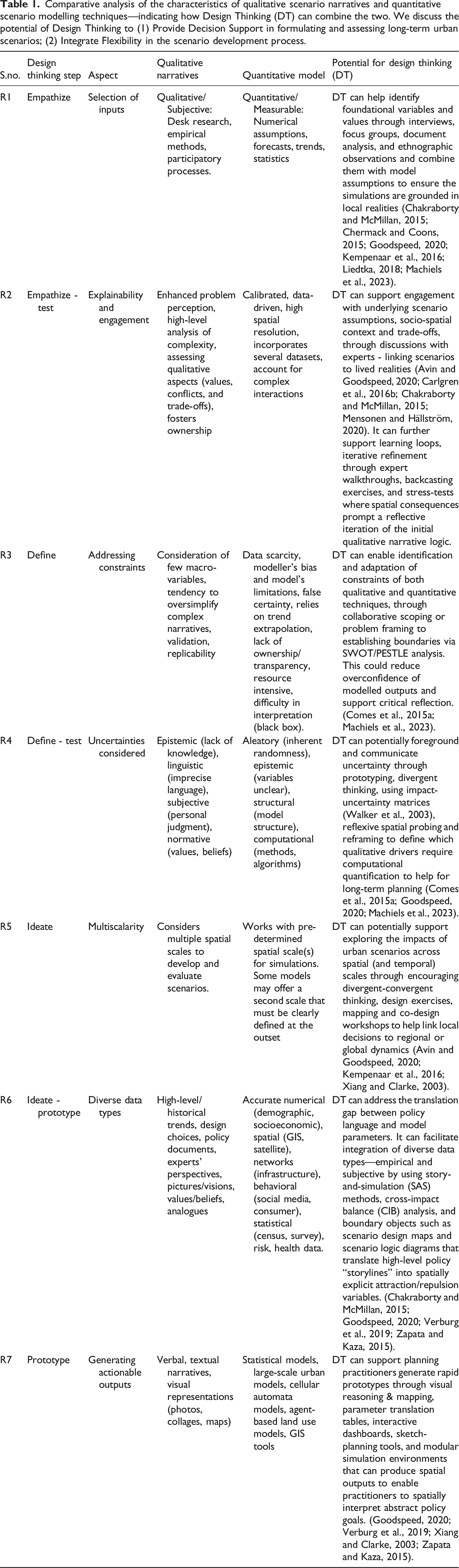
FutureScapes is a seven-step scenario development approach that operationalizes Design Thinking (DT) as a procedural scaffold to blend qualitative narratives and computational land-use models (Figure 1). Grounded in the Hasso Plattner/Stanford Design Thinking framework—comprising the Empathize, Define, Ideate, Prototype, and Test phases (Plattner et al. 2012, 2015)—the approach enhances the strategic relevance of computational land-use scenarios by systematically embedding the situated knowledge of expert stakeholders into the modelling process 1. This methodology shifts the modeling workflow from a linear translation exercise to an iterative, non-linear synthesis, where practitioners’ spatial reasoning and institutional values improve computational parameters. By balancing narrative storytelling with analytical rigor, FutureScapes provides a robust framework to navigate long-term urban uncertainty and translate complex spatial dynamics into actionable policy recommendations. Flowchart of the FutureScapes approach, which uses design thinking to blend computational models and scenario narratives for designing urban futures.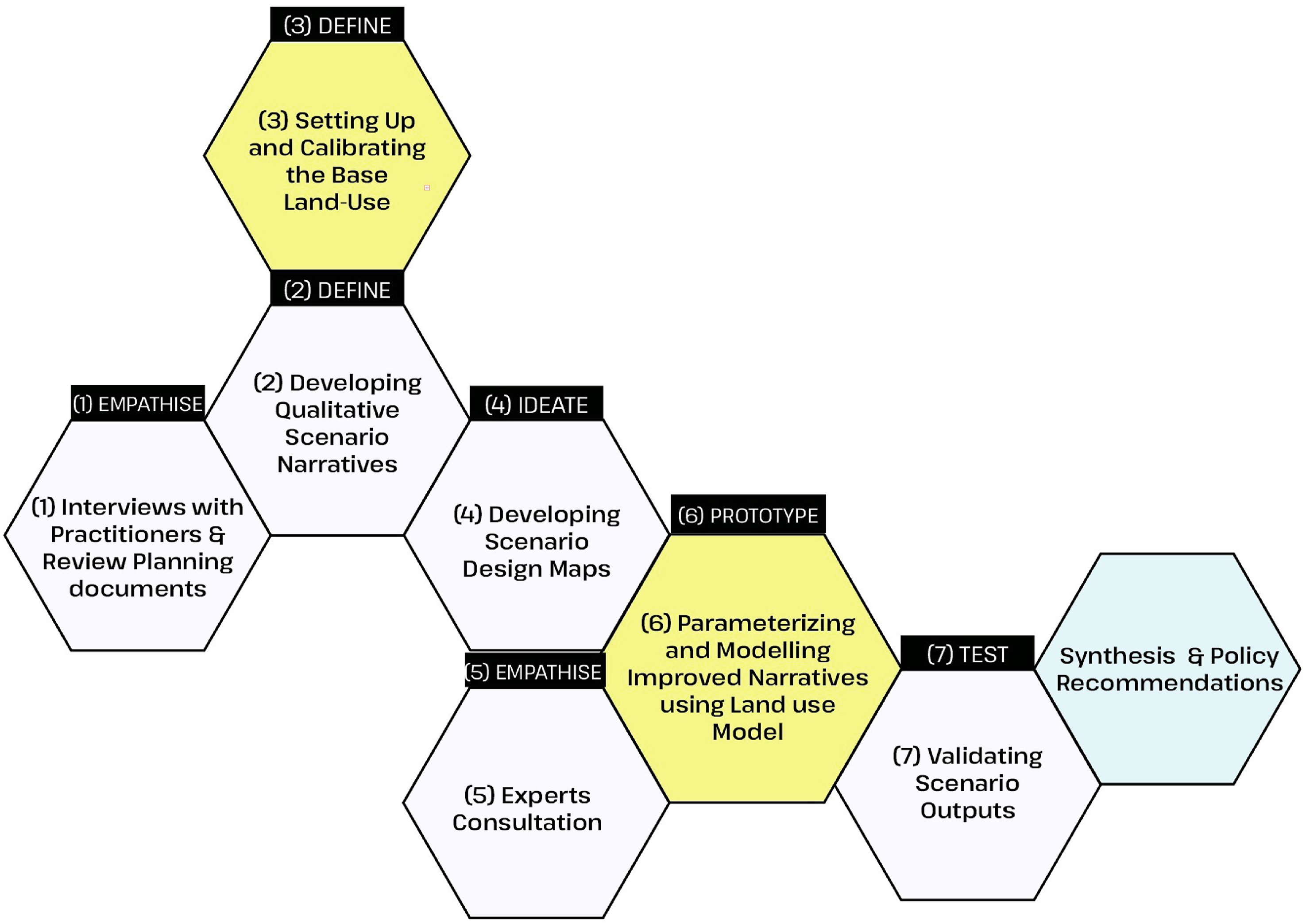
Step 1: Empathize (interviews with practitioners & context mapping)
Understanding the socio-economic context of urbanization is essential for grounded scenario development. Through semi-structured interviews with practitioners responsible for both operational and strategic planning decisions and thematic document analysis, Step 1 identifies the foundational spatial drivers, latent institutional constraints and spatial priorities that inform the subsequent development of scenario narratives. This ensures that the subsequent modeling environment is grounded in the professional priorities and strategic reasoning of the practitioners who navigate the city’s regulatory landscape.
Step 2: Define (scoping & developing qualitative scenario narratives)
Based on findings from Step 1, narratives are developed to reflect the strategic planning ambitions of the region. The narratives draw on extensive desk research into future urbanization, mobility, environmental trends, and demographic pressures. The scenarios developed in this study are best described as explorative planning scenarios, intended to examine how different policy directions and development visions might affect urban form (Börjeson et al., 2006; Chakraborty and McMillan, 2015). We steer away from the scenario axes approach, as the intent is not to explore the plausibility space, but to develop socio-economically relevant scenarios for expert feedback. Given the reliance on expert knowledge, the number of scenarios and the time horizon must strike a balance between adequately capturing the region’s goals and minimizing cognitive burden (Comes et al., 2011; Xiang and Clarke, 2003).
Step 3: Define (setting up and calibrating the base land-use model)
To simulate land-use dynamics over time, we establish the modelling boundary and then select a stochastic computational model that allows for configurable land-use classifications (extending beyond land cover alone), accommodates functional interactions between land-use categories, integrates diverse drivers of change, and visualizes temporal/time-stepped simulation for understanding spatial trade-offs. Model selection also considers the need for granular output and rapid run-time, drawing on established precedents (Kok and Delden, 2009; Noszczyk, 2019; Verburg et al., 2019; Xiang and Clarke, 2003). For this study, the model is calibrated using context-specific data and validated through probability mapping to ensure robustness and fitness-for-purpose for scenario simulation (Casali et al., 2022).
Step 4: Ideate (developing scenario design maps)
The Ideate phase addresses the “translation gap” between policy language and model parameters, operationalized through the steps detailed in Table 1. Eliciting spatial feedback is operationalized through sketching and mapping techniques to support collaborative framing and creative synthesis (Cross, 1982). Scenario design maps serve as semi-quantitative mediating instruments to visualize spatial logic and sectoral priorities in each scenario narrative from Step-2 (Kunze et al., 2012). The maps are created using a combination of hand-sketched and digital tools to represent key elements—growth nodes, mobility corridors, ecological assets—based on official planning documents and stakeholder inputs, presenting compelling urban visions. Broad distance and area calculations may be included to support representation at scale. Using a graphics editor, the maps are stylized to maintain consistency with computational model outputs, enabling experts to relate design concepts to simulation parameters and provide concrete spatial feedback.
Step 5: Empathize (experts’ consultation)
Expert consultation serves two purposes: (1) to evaluate the base model assumptions, and (2) to elicit structured expert stakeholder feedback on the scenario narratives. The design-thinking-driven exercise deviates from prescriptive consensus-building in favor of surfacing diverse viewpoints. The use of scenario design maps plays a central role, enabling experts to express development and design preferences, priorities, and trade-offs without being constrained by a rigid modelling environment (Nassauer and Opdam, 2008; Çalışkan, 2012).
The expert group is selected for technical depth in domains critical to regional urbanization—urban planning, infrastructure, water management, climate adaptation, and regulatory frameworks—rather than for broad demographic representativeness. In the scope of this study, we propose conducting the consultation in two iterative rounds (Liedtka, 2018). The first round captures broad reactions and general feedback on both the narrative scenarios and baseline model outputs. The second round involves a deeper, guided exploration of the scenarios, focusing on specific sectoral assumptions, parameters, and their implications.
Step 6: Prototype (parameterizing and modelling improved narratives)
Narrative assumptions refined in Step-5 are translated into model-ready inputs through systematic parameterization. This involves extracting spatial “clues” from the narratives (Delden and Hagen-Zanker, 2009) and design maps—such as preferred or inevitable growth areas, zoning constraints, and demand estimates. These inputs are coded into model parameters such as interaction rules, exclusion zones, and attractor weights.
Step 7: Test (validating scenario outputs)
Validation is carried out through two complementary steps. First, computational validation uses Monte Carlo simulations and landscape metrics—such as kernel density and patch indices—to test model stability and spatial coherence. Monte Carlo simulations are run with variable random seeds to assess consistency and differentiation across scenarios. A representative map is selected per scenario for further analysis (see Supplemental Material). Second, expert feedback is gathered on the model outputs in consultation rounds to assess whether the outputs reflect contextual priorities and narrative intent. By doing so, the validation step ensures that the scenarios are both technically robust and contextually grounded.
Synthesis and policy recommendations
Scenario outputs are evaluated against regional planning goals. By synthesizing insights across narratives—rather than prioritizing a single “best” outcome—FutureScapes supports policy recommendations that reflect a range of plausible futures. These recommendations inform the direction of urbanization strategies, helping to align computational evidence with long-term development goals.
Implementation of FutureScapes to the case of the Metropolitan Region of Amsterdam (MRA)
We apply the FutureScapes approach to model urbanization strategies for the Metropolitan Region of Amsterdam (MRA), Netherlands for the year 2050 (Figure 2). MRA is a major socio-economic hub in Western Europe comprising 30 municipalities and the Amsterdam Transport Region. It houses 2.5 million residents, 300,000 enterprises, 1.5 million jobs and is highly vulnerable to climate change due to its extensive low-lying land and faces acute challenges such as housing shortages, mobility constraints, and socio-economic inequality. Illustrating the detailed application of the FutureScapes Scenario Development Approach on the case of the Metropolitan Region of Amsterdam (MRA) following the Workflow in Fig 1.
Step 1: Empathize (interviews with practitioners)
Twenty semi-structured interviews were conducted with senior practitioners, including urban planners, policy advisors, climate adaptation leads, and sustainability specialists. These interviews, analyzed in prior studies by the authors (Krishnan et al. 2023, 2024), provided a foundational understanding of spatial priorities, planning tensions, and long-term transformation pathways in the MRA.
Step 2: Define (developing qualitative scenario narratives)
Factors determining Scenario Narratives for the MRA (in addition to the Business as usual scenario (BAU)): Planned growth (PG) and 15-Minute City (15 MC).
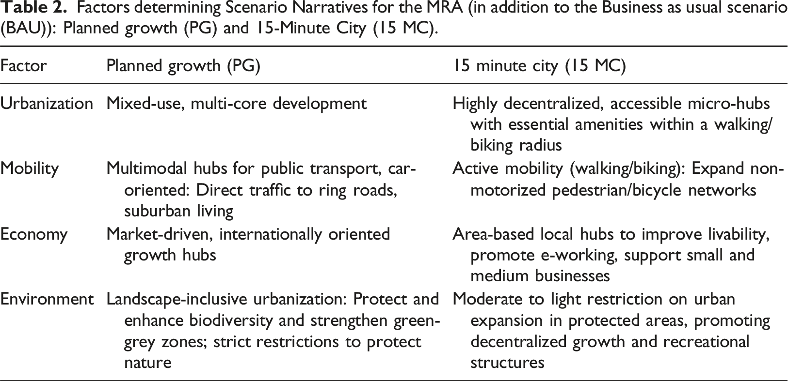
Business as Usual (BAU): Continuation of current trends with minimal policy innovation. Restrictions around protected zones remain, but no new spatial strategies are introduced.
Planned Growth (PG): Reflects the official MRA strategy, promoting seven high-density, mixed-use hubs with enhanced intercity transport connectivity and biodiversity preservation.
15-Minute City (15 MC): A decentralized model prioritizing self-sufficiency and proximity to services through the creation of numerous mixed-use micro-hubs accessible within 15 min by walking or cycling. The scenario draws from a growing global interest in accessibility-based planning, compact urban form, and infrastructure aging - especially in the aftermath of the COVID-19 pandemic.
Step 3: Define (setting up and calibrating the base land-use model)
We selected Metronamica, a stochastic, cellular automata-based, spatially explicit land-use model (Van Delden and Vanhout, 2018) (https://www.metronamica.nl/). The model simulates yearly urban dynamics and allows interaction among up to 32 land-use categories (LUCs). The MRA model was calibrated using data from 1996 to 2006 and validated with 2006-2016 data. Calibration focused on aligning model simulations with observed patterns using Kappa performance metrics. The resulting fuzzy kappa score of 0.90 outperformed both random (0.87) and neutral (0.82) models (Vliet et al., 2013), confirming robust model performance (see Supplemental Material).
Certain modelling decisions were shaped by practical constraints, such as the availability of compatible spatial data during the calibration period and conceptual maps available in MRA’s policy documents (e.g., mobility maps from MRA’s open data portal and geoservers), as well as the region’s broader spatial goals.
Step 4: Ideate (developing scenario design maps)
Scenario design maps were developed in a semi-quantitative manner to present a consistent spatial representation of the narratives and to elicit expert feedback that could be parameterized (see Figure 2 and 3). For each scenario, we reviewed relevant literature to understand its spatial representation. For instance, in the 15 MC scenario, we used GIS tools (TravelTime) to calculate travel distances and identify growth hubs (see Figure 3 Step 3). These hubs informed preliminary design maps that depict the distribution of urban functions, transport networks, and development nodes. Illustrating Three stages of the FutureScapes approach: Step-4 (Scenario Design Maps as boundary objects), Step-5 (Expert stakeholder feedback loops), and Step-6 (Parameterization of qualitative narratives into modeled spatial outputs).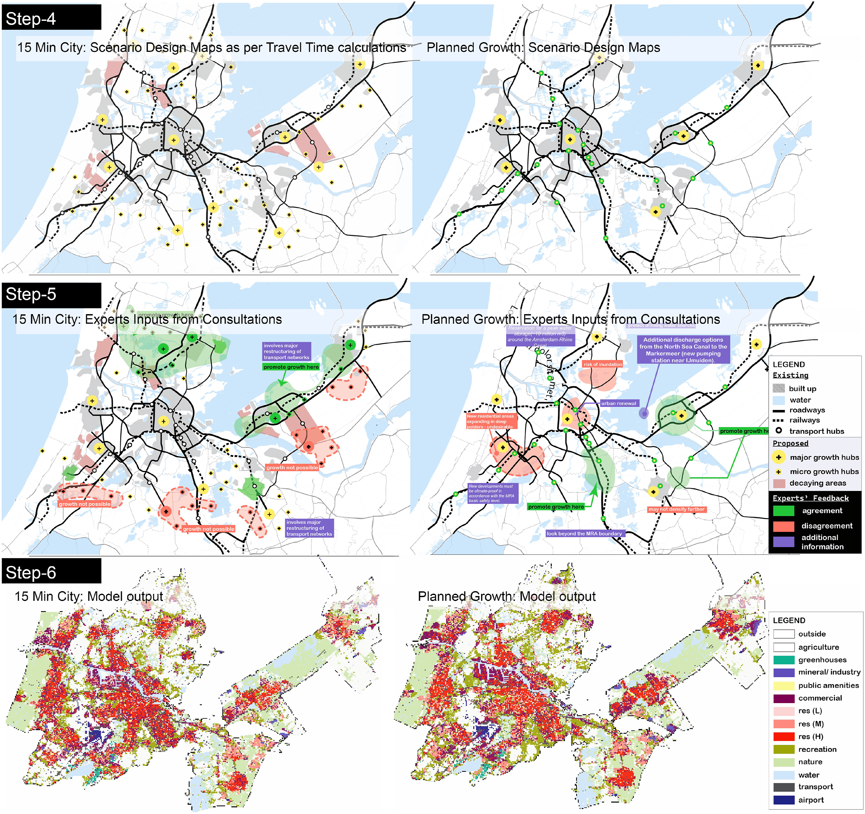
We made a design decision to emphasize urban growth hubs and highlight areas of decay or redevelopment, as these are central to eliciting spatially explicit feedback from experts. The final maps for each scenario were drawn to approximate scale, representing the distances and sizes of urban parcels.
Step 5: Empathize (experts’ consultation)
In Fall 2021, we convened nine expert stakeholders who steer decision-making for urban planning and policy in the MRA for a 3-h consultation session to review the scenarios. The group included two planners working on climate adaptation, two policy advisors specializing in scenarios, two land-use specialists, one urban designer, one landscape architect, and one urban water expert. Due to COVID-19 restrictions, the consultation was conducted online via Microsoft Teams and the Mural online collaboration board. Detailed consultation protocols, workflow, and participant profiles are available in the Supplemental Material.
We presented the data sources used for model calibration and performance metrics (e.g., Kappa indices, clumpiness, kernel density), along with a comparison map showing actual versus simulated growth. Experts reviewed the model’s performance and the BAU scenario simulation for 2015–2050, generally validating the model’s depiction of urban growth. They recommended further sub-categorization of land uses, particularly for mixed-use areas and green spaces.
Feedback on narratives was structured around two interactive rounds, where experts worked in small groups to review all narratives and minimize groupthink (Wright and Goodwin, 2009).
Round 1 focused on spontaneous insights, such as agreement or disagreement with narrative assumptions and growth patterns. These discussions led to debates among urban designers, planners, and water management experts, with feedback ranging from agreement (“This is already happening”) to strong disagreement (“This will never work because it requires major restructuring”), along with more localized insights (“Innovation is only possible in this neighbourhood”).
Round 2 involved a structured evaluation of the scenario design maps using guided questions (Table 2). Experts marked key locations on the maps, identifying growth hubs (e.g., pilot projects, circular economy potential, protected areas, major projects, and connectivity hubs) and stressors (e.g., subsidence, decaying areas, heat islands, rising land prices, and pollution/noise). In total, 68 pieces of feedback were provided across the three narratives, identifying areas to promote or discourage growth, as well as unrealistic situations and high-risk locations.
While the BAU and PG scenarios were deemed realistic, concerns were raised that car-oriented suburban growth may counteract sustainability goals. The 15 MC scenario, although praised for its potential to improve recreational access, reduce climate impacts, and alleviate the housing crisis, was met with skepticism due to its expansion into flood-prone and nature-conserved areas—potentially fragmenting green networks and requiring policy adjustments to accommodate higher-density development.
Experts recommended increasing the sub-categorization of land uses in the model to provide a more detailed representation of urban functions. However, this was not feasible due to the need to balance model complexity with data availability and computational reliability: (a) critical data for mixed-use classes was unavailable in a format compatible with the model, and (b) adding subcategories would have required extensive pre-processing and recalibration to reflect the dynamics of additional categories. Drawing on insights from similar case studies using Metronamica (Guzman et al., 2020; Lahti, 2008), the model was limited to 13 land use categories (LUCs).
Step 6: Prototype (parameterizing & modelling improved scenario narratives)
Based on expert consultations and official statistics, the narratives were quantified as thoroughly as possible. Each narrative was systematically analyzed to estimate its spatial impacts (e.g., growth, degrowth, city centers) using location-specific feedback from the scenario design maps. These impacts were first assessed semi-quantitatively (from very strong increase to very strong decrease), then translated into specific numerical values, growth curves, and input maps.
While the consultation provided substantial factual input, not all assumptions behind developments were clearly stated. Some were validated using official datasets, though others could not be fully verified. Despite the model’s need for more detailed input, critical assumptions about work–live patterns, mobility, and shifts in nature or agricultural land were successfully parameterized.
Future space demands were derived from regional population projections and the Planning Capacity Monitor. Simulations were run from 2016 to 2050, assuming consistent demographic trends and space demands. Zoning layers, accessibility metrics, and interaction rules—such as attraction and repulsion between land uses—were adjusted to reflect the land-use logic for each narrative, with scenario-specific rules applied.
For example, in the PG scenario, mixed-use growth hubs were promoted by increasing attraction at key transport or motorway junctions. This was implemented by introducing attractor points and zoning radii to stimulate development in targeted areas. Table 3 outlines the detailed parameterization of narratives, while Figure 4 displays the resulting computational scenario outputs. An ex-post evaluation of these outputs helped identify key parameters influencing each scenario, allowing adjustments to align with both narrative goals and expert feedback. Additional maps were also introduced to resolve inconsistencies. • In the PG scenario, five additional zoning maps were created to promote mixed-use development in seven hubs, integrate land reservations aligned with regional landscape policy, and simulate zoning for residential, commercial, and industrial land by 2050. • In the 15 MC scenario, two additional zoning maps and an infrastructure network map (residential roads) were introduced to support mixed-use hubs within a 15-min biking radius. Despite these adjustments, the modeled scenario diverged from the idealized narrative. Achieving 15-min access would require major restructuring of the road network and loosening nature protection policies to allow greenfield expansion—neither of which was supported by the experts. However, zoning restrictions for nature areas were eased slightly in the model to permit limited expansion. Parameterising Scenario Narratives (Step-5), detailed table moved to Supplementary Material. Computational scenario outputs illustrating different urban growth patterns for the Metropolitan Region of Amsterdam in 2050: (a) Business-as-Usual (BAU Scenario), (b) Planned Growth (PG Scenario), and (c) 15-Minute City (15 MC Scenario). Each scenario includes a zoom-in on urban expansion patterns in the North Sea Canal Region to highlight variations in land-use allocation, supporting reflection on future policy directions.
.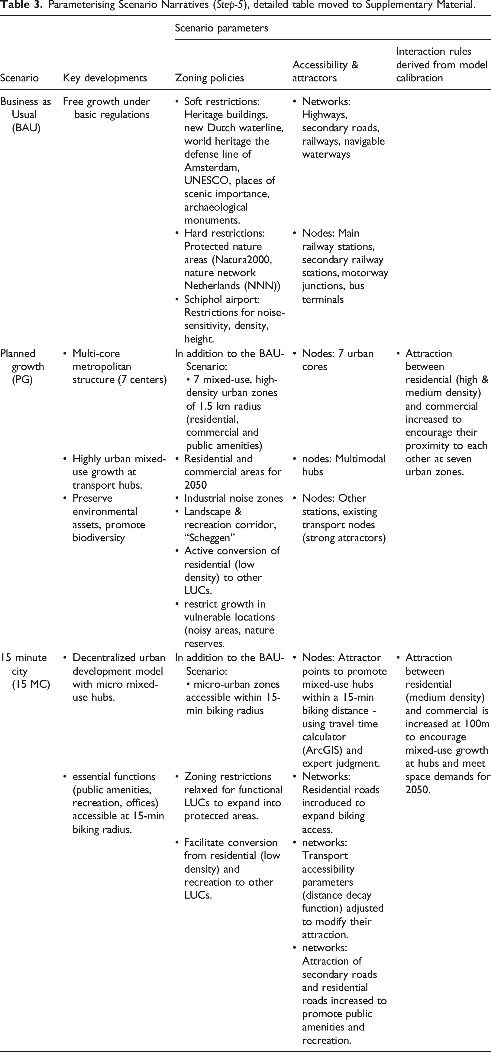
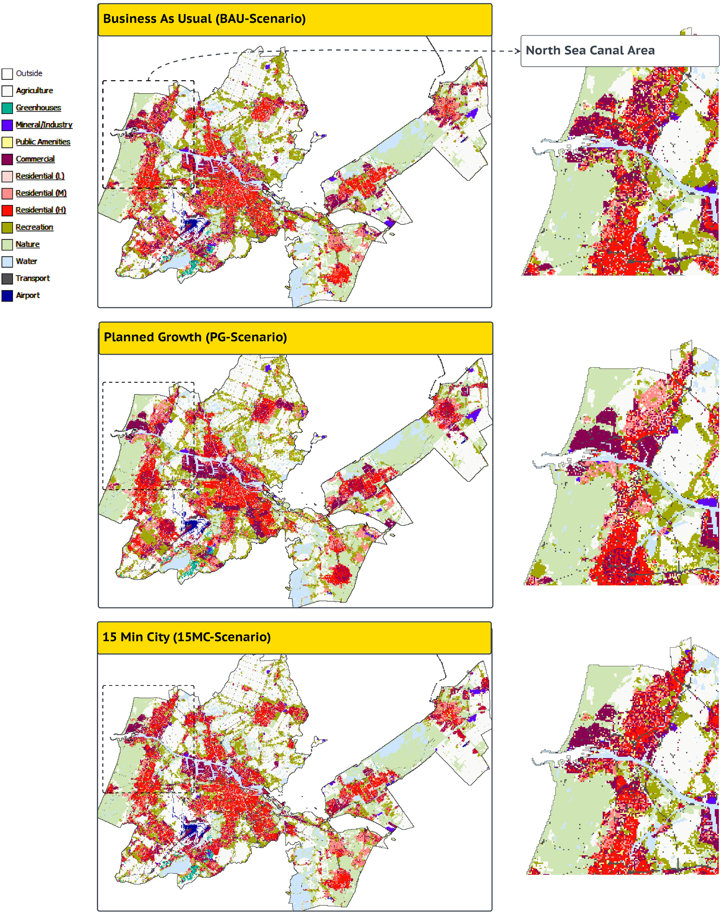
Figure 3 illustrates the development process for the 15 MC scenario, based on Figure 2. Of the 86 originally proposed mixed-use hubs (based on travel time calculations), 52 remained after incorporating expert feedback. The final computational scenario simulated growth at 46 hubs, constrained by spatial/network limitations and insufficient space demand.
Experts also emphasized the vulnerability of drinking water sources due to subsidence and rising sea levels, recommending protective zoning measures for freshwater reserves. Accordingly, zoning layers were updated to discourage built-up functions in these areas in the refined scenarios.
Step 7: Test (validating scenario outputs)
Each scenario was tested using 100 independent Monte Carlo iterations, producing pixel-level probability surfaces for every land-use class. From these ensembles, we extracted standard deviation (SD) and entropy measures to serve as quantitative indicators of model stability and spatial ambiguity.
Results indicate that core urban areas had low variability (SD values between 0.008 and 0.03), reflecting a high degree of predictive confidence in areas with well-established development trajectories. In contrast, urban peripheries and mixed-use corridors exhibited high dispersion due to overlapping land-use categories and competing development logics, indicating plausible but complex growth patterns.
These outputs—particularly the spatial zones with high uncertainty—highlight areas for future deliberation, negotiation, or targeted policy intervention.
Synthesis and policy recommendations
The policy recommendations presented in this study are derived by synthesizing the modelled scenario outputs with qualitative scenario narratives and practitioner inputs—and not solely from computational outputs. This blended approach is central to the FutureScapes approach. It reflects the understanding that computational models and narratives need not operate in a linear sequence—where one feeds into the other—but rather in an iterative manner, where they mutually shape and refine the scenario development process. This ensures that tacit knowledge of expert stakeholders and their value-based judgments are incorporated into model assumptions (Alcamo and Henrichs, 2008; Giaoutzi and Sapio, 2012; Kok and Delden, 2009).
We assessed the three computational scenarios against the Metropolitan Region of Amsterdam’s (MRA) strategic goals for health and sustainability (Amsterdam, 2021). Several mismatches emerged between modeled outputs and narrative expectations.
Notably, the 15-Minute City (15 MC) scenario aimed to improve recreational access by decentralizing growth into walkable micro-hubs. Experts expressed concerns about the feasibility of significant infrastructure restructuring—particularly regarding the road network—and highlighted institutional path dependencies that may hinder the implementation of micro-hubs across the region. Furthermore, spatial realization of this scenario required trade-offs, such as easing development restrictions in ecologically sensitive nature reserves.
In contrast, the Business-as-Usual (BAU) scenario—despite lacking targeted interventions—showed the shortest average walking distance between residential and recreational functions (0.44 km), better aligning with the MRA’s health objective of promoting active mobility. This finding underscores the importance of evidence-based urban decision-making. Widely promoted planning heuristics, such as the 15-min city, often presume that proximity-based design inherently ensures accessibility. However, without empirical validation, such assumptions may result in trade-offs and misalignments between policy goals and implementation realities, potentially leading to inefficient or costly outcomes.
Similarly, the second regional objective—supporting sustainable development in the North Sea Canal zone—was realized differently across scenarios. All three scenarios simulated urban expansion to the northwest, northeast, and southwest (Figure 4), but differed in their spatial allocation of recreational areas. The PG scenario promoted commercial intensification in this corridor, which experts noted could justify policy shifts to formally recognize its emerging strategic role. However, trade-offs between economic development and ecological preservation—particularly the spatial demands of energy transition infrastructure—remained unresolved and contentious, illustrating tensions that computational models alone cannot resolve.
Further, while all scenarios met the projected space demands for 2050, experts flagged problematic expansions into flood-prone and subsidence-affected areas—particularly in the southwest and central MRA. Although these risks were detectable through land-use overlays, they were not embedded in the model’s constraint logic. Experts recommended precautionary planning measures to limit densification in such zones and advocated for the integration of adaptive strategies into zoning frameworks. These judgments could only be surfaced through expert deliberation, reaffirming the critical role of expert insight in enhancing and contextualizing model outputs.
The insights from this study challenge the assumption that scenario ambitions necessarily translates into spatial efficiency. They emphasize the value of qualitative assessments in combination with model metrics to produce robust, policy-relevant insights.
Evaluating the role of design thinking in blending computational models and scenario narratives
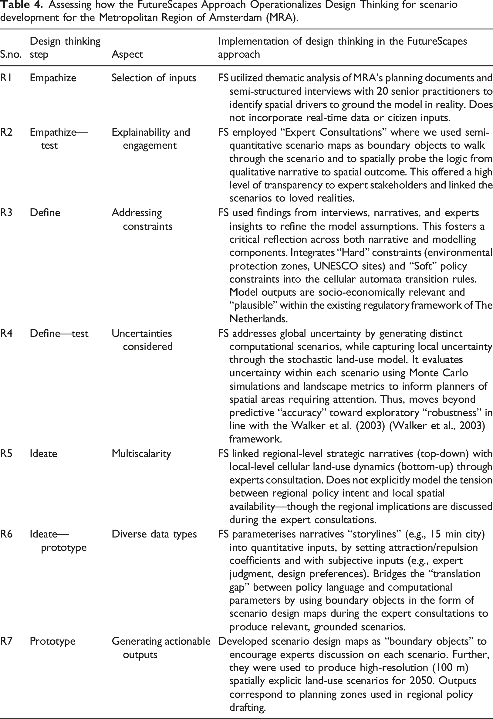
Assessing how the FutureScapes Approach Operationalizes Design Thinking for scenario development for the Metropolitan Region of Amsterdam (MRA).
The application of FutureScapes to the MRA region demonstrates its capacity to resolve persistent tensions in urban analytics. By mapping the implementation against key methodological aspects—including multiscalarity, explainability, and the management of uncertainty—we provide a template for transparent, expert-led scenario development. Our findings suggest that the integration of Design Thinking provides the necessary procedural rigor to navigate epistemic uncertainty (Walker et al., 2003).
The case study illustrates that FutureScapes effectively integrates diverse inputs, specifically the design preferences and situated knowledge of expert stakeholders. These inputs, elicited through document analysis and practitioner interviews, were translated into quantitative model parameters via scenario design maps (Table 4). Simulation using Metronamica enabled the production of spatially explicit scenarios at a fine resolution (100m), significantly enhancing both interpretability and strategic relevance [R7].
By framing narratives around regional priorities and utilizing expert consultations to address trade-offs and spatial dynamics—supported by design maps rendered to match expected model outputs—the approach improved the clarity and communicability of complex spatial decisions [R2]. Crucially, it validated relevance by grounding simulations in local knowledge, including informal rules, unmodelled risks, and context-sensitive constraints, thereby mitigating model overconfidence [R3]. Practitioners contributed critical tacit knowledge regarding community resistance, adaptive reuse potential, and redevelopment priorities. While limited by its current exclusion of non-expert inputs, FutureScapes offers a high-resolution, actionable pathway for regional practitioners to co-produce urban futures that are both narratively rich and computationally sound.
The findings support our core hypothesis: Design Thinking can bridge the epistemological divide between models and narratives in urban planning. The approach facilitated a bidirectional co-evolution between measurable trends and professional spatial reasoning [R6]. Unlike general participatory modelling, FutureScapes utilizes specific design interventions—such as parameter co-design and reflexive spatial probing—that leverage professional domain expertise to bridge the gap between narrative intent and computational execution.
The primary scientific contribution of FutureScapes lies in its capacity for reflexive reframing. While frameworks like GeoDesign incorporate evaluation loops to assess a design’s impact, Step-6 utilizes model-generated maps as probes to reflexively redesign the initial qualitative narratives. Consequently, the approach does not merely use the model to evaluate the scenario; it closes the loop between “story” and “simulation,” ensuring that qualitative futures are grounded in the emergent spatial logic of the quantitative model.
Regarding uncertainty [R4], practitioners highlighted the difficulty of estimating space demands amidst rapid socioeconomic shifts. They noted that the flexibility of scenario narratives, supported by Metronamica’s rapid runtime, allowed for shifting assumptions while remaining policy-relevant. Monte Carlo simulations were utilized to assess internal model uncertainty, flagging spatial areas requiring further scrutiny. Finally, model assumptions were refined using location-specific expert insights and supplementary data, further mitigating the epistemic uncertainty inherent in long-term urbanisation strategies.
FutureScapes advances these traditions by integrating their complementary strengths into a unified, design-thinking-led workflow. Its primary contribution lies in operationalizing the synthesis of narratives and models reflexively inform one another through structured Design Thinking steps. Within this framework, scenario design maps function as boundary objects (Star and Griesemer, 1989) that translate narrative logic into semi-quantitative spatial representations (scenario design maps), facilitating the elicitation of situated knowledge and precise model parameterization.
In doing so, FutureScapes demonstrates that computational models can serve not only as evaluative benchmarks but as reflexive instruments for the collaborative exploration of long-term spatial strategies. This represents a methodological synthesis that moves beyond the linear “story-to-simulation” pipeline common in previous approaches. Furthermore, by following the framework of Walker et al. (2003) (Walker et al., 2003), FutureScapes systematically manages epistemic uncertainty through expert elicitation and addresses structural uncertainty through the reflexive feedback loops characteristic of the Design Thinking process.
Limitations & future work
Despite its methodological contributions, the FutureScapes approach presents several limitations that warrant further refinement.
First, practitioners involved in Step-5 noted that the departure from the familiar 2x2 scenario axis framework—a standard in scenario planning practice - was initially disorienting. While these matrices are increasingly critiqued for oversimplifying multidimensional uncertainties (Trutnevyte et al., 2016), they remain a primary institutional heuristic. FutureScapes deliberately moved beyond this by grounding scenarios in socio-economic realities of the MRA. For instance, the 15 MC scenario reflects shifts toward non-motorized mobility and polycentric growth promoted post the COVID-19 pandemic. By parameterizing these narratives into a model capable of capturing complex land-use interactions, the approach enabled a nuanced evaluation of competing spatial demands, though at the cost of the simplicity provided by traditional frameworks.
Second, the approach prioritized engagement with expert stakeholders over broader community participation. While this decision allowed for technical depth and alignment with institutional priorities, it potentially constrained the diversity of the scenario narratives. Broader engagement with citizens and community organizations could reveal alternative values and perspectives that expert-driven processes may overlook. Future iterations of FutureScapes should explore methods to integrate community-driven inputs to enhance inclusivity, and the broader societal relevance of planning outcomes.
Third, the study highlights tensions in multiscalar thinking ([R5] in Table 1 and 4). Scenarios like the 15 MC require analysis across nested scales—from local adaptive reuse to regional mobility dynamics. Our findings demonstrate how model selection influences scenario representation: the hub-based growth in the PG scenario aligns well with the cellular automata (CA) logic of Metronamica, whereas the decentralized logic of the 15 MC scenario might be better captured by agent-based models (ABM) that simulate behavioral processes (González-Méndez et al., 2021; Li and Gong, 2016). This study prioritized analytical consistency over scenario-specific model selection to ensure direct comparison, but this choice may have constrained the representation of certain narratives. Future research should investigate strategies for cross-model comparisons without compromising structural coherence.
Fourth, the model was calibrated on historical data (1996–2016), which does not inherently incorporate transformative regime shifts or future policy interventions. The assumption that behavioral patterns derived from past trends will persist introduces a common constraint in land-use forecasting. While expert consultations helped mitigate this reliance on stationarity, the use of historically calibrated models remains a limitation when addressing unprecedented urban futures (Hewitt et al., 2022; Noszczyk, 2019).
Finally, the study validated the scenarios through computational methods and did not include a planned third expert consultation to review final modelled outputs. Additional rounds of expert consultation could refine model assumptions, and stress-test scenario logic, to strengthen the legitimacy and usability of outputs for decision-making. These steps remain a priority for future research.
Concluding remarks
The FutureScapes approach demonstrates the value of integrating qualitative narratives and expert insights into computational modeling to produce spatially grounded urban scenarios that reflect the socio-economic realities of the region. Rather than treating models as isolated technical tools or narratives as abstract visions, FutureScapes synthesizes both through a design-thinking-led, iterative process. This enables expert stakeholders to evaluate and refine model assumptions, visualize alternatives, and refine outputs using specific contextual knowledge.
Existing scenario development traditions such as GeoDesign, exploratory scenario modelling, and participatory modelling demonstrate strong precedents for linking models with stakeholders (see Section 0.0). However, these approaches often remains methodologically fragmented when applied to metropolitan or regional urbanisation strategies. FutureScapes’ unique contribution lies in its operationalization of narrative creation, spatial ideation, parameter translation, and model testing as interconnected design activities. By doing so, it enables computational models to serve not only as evaluative tools but as active co-design instruments. This advances the field by offering a generalizable method for blending narratives and models that is transparent, replicable, and suited to the early strategic stages of long-term planning.
The introduction of the scenario design maps serves as a critical spatial probe, facilitating a deeper reflection on the generated scenarios. It enhances the spatial reasoning capabilities of planning practitioners, supporting deliberation on land-use trade-offs and development choices in a visual, place-based format.
FutureScapes’ capacity to integrate diverse information sources—including empirical data, policy goals, expert judgment, and stakeholder values—is essential for addressing contemporary urban planning challenges defined by deep uncertainty, climate risk, and accelerating technological change. By providing a replicable framework for developing scenarios that are spatially and institutionally grounded, FutureScapes reflects real-world constraints, regional objectives, and the situated expertise of decision-makers. Ultimately, this enhances the relevance, usability, and strategic value of scenario planning for uncertain urban futures.
Supplemental material
Suppplemental Material—FutureScapes: A design thinking approach to blending computational models and scenario narratives for urban futures
Suppplemental Material for FutureScapes: A design thinking approach to blending computational models and scenario narratives for urban futures by Supriya Krishnan, Hedwig van Delden, Nazli Yonca Aydin, Tina Comes in Environment and Planning B: Urban Analytics and City Science
Footnotes
Acknowledgments
We would like to express our gratitude to Roel Vanhout (Research Institute for Knowledge Systems (RIKS), the Netherlands) for his invaluable technical expertise in setting up the land use model. Special thanks to Aarthi Sundaram and Hongxuan Yu, former master’s students at TU Delft, for their significant assistance in calibrating and validating the base land use model. Our sincere appreciation also goes to the participants of the expert consultation for their time and insightful feedback on both the model and scenarios, and to Mariken Gaanderse for her assistance in facilitating the consultation process. This paper was developed as part of the PhD research project “The Future Ground,” supported by the Resilience Lab at the Faculty of Technology Policy and Management at TU Delft and funded by the Delft Technology Fellowship.
Author contributions
Author 1: Conceptualization, Methodology, Software, Modelling & analysis, Visuals, Writing—original draft, Writing—review & editing, Visualization. Author 2: Modelling & Analysis, Methodology, Writing—review. Author 3: Conceptualization, Methodology, Supervision, Writing—original draft, review & editing, Project administration, Resources. Author 4: Conceptualization, Methodology, Supervision, Writing—original draft, review & editing, Project administration, Resources, Funding acquisition.
Funding
This publication is part of the PhD research of the first author titled “The Future Ground: Urban Planning Under Climate Uncertainty” at TU Delft and was primarily funded by the TU Delft Technology Fellowship and the Faculty of Technology Policy and Management. The authors received no additional financial support for the research, authorship, and/or publication of this article from any other source.
Declaration of conflicting interests
The authors declared no potential conflicts of interest with respect to the research, authorship, and/or publication of this article.
Data Availability Statement
Data sharing is not applicable to this article as no datasets were generated or analyzed during the current study.
Supplemental material
Supplemental material for this article is available online.
Author biographies
References
Supplementary Material
Please find the following supplemental material available below.
For Open Access articles published under a Creative Commons License, all supplemental material carries the same license as the article it is associated with.
For non-Open Access articles published, all supplemental material carries a non-exclusive license, and permission requests for re-use of supplemental material or any part of supplemental material shall be sent directly to the copyright owner as specified in the copyright notice associated with the article.