
Abstract
High-density cities like Hong Kong are shaped by volumetric urban design, featuring three-dimensional pedestrian networks and integration of metro stations with property developments under transit-oriented development (TOD) principles. Conventional urban form metrics, which are largely two-dimensional, cannot capture these volumetric characteristics. This study addresses this limitation by developing quantitative metrics for three core elements of volumetric urban design: compression, multi-level connectedness, and functional mix. Drawing on high-resolution data on pedestrian networks, building data, and points of interest, we analyse case metro station areas in Hong Kong. The results show that 57% of buildings exhibit mixed use, characterised by pronounced functional stratification: employment- and visitor-oriented activities are concentrated within podiums, while residential uses dominate the upper floors. This vertical layering, encouraged by TOD principles, is accompanied by substantial spatial compression and high levels of multi-level pedestrian connectivity across buildings and transport nodes. In contrast, conventional two-dimensional measures fail to capture up to 91% of spatial compression and 52% of pedestrian connectedness, and systematically misclassify all buildings as mono-functional. By explicitly accounting for multi-level connectivity, intensified space use, and vertical functional mix—key hallmarks of volumetric cities—our approach proposes a transferable framework for measuring and analysing volumetric urban design. These findings have implications for urban analysis, urban design research, and planning policy, providing researchers and practitioners with robust tools for assessing high-density, multi-layered urban environments.
Keywords
Introduction
Cities worldwide face the persistent challenge of balancing rapid population growth with limited available land, a dilemma that is especially acute in Asia (Al-Kodmany, 2018; Wang, 2020). In response, urban development has increasingly focused on creating high-density, highly connected, and multifunctional environments to maximise land use efficiency (Harris, 2015). Recently, the concept of the volumetric city has emerged, capturing the complexity and multi-layered nature of built environments in Asian cities such as Tokyo and Hong Kong (Bruyns et al., 2021; Shelton et al., 2013). Volumetric urban design extends beyond mere verticality, encompassing the compression and integration of public spaces and buildings to accommodate diverse urban functions within interior and multi-level spatial configurations.
Volumetric urban design builds on earlier urban theories, such as new urbanism, the compact city, and vertical urbanism (Lin and Gámez, 2018), all of which advocate dense, mixed-use, and walkable environments in response to car-oriented development and urban sprawl. These ideas have shaped contemporary planning movements, including the 15-min city (Rao et al., 2024). Specifically, vertical urbanism extends these principles to high-rise, space-efficient environments, shifting from the modernist focus on skyscrapers toward more integrated, socially engaging three-dimensional systems that connect infrastructure, buildings, and public spaces across vertical and horizontal layers (Harris, 2015). While verticality has characterised large-scale developments in cities such as New York, Dubai, and Chicago, recent research highlights the volumetric city as a special model, particularly evident in Asian contexts (McNeill, 2020). In Hong Kong, volumetric development is characterised by highly compressed, multi-layered, and internalised environments that integrate buildings, pedestrian networks, and privately owned public spaces (Shelton et al., 2013). Volumetric design is thus best understood through key elements such as density, compactness, diversity, and connectedness (Lehmann, 2016), which capture both the physical compression of space and the integration of diverse functions across multiple levels (Bruyns et al., 2021). Despite increasing attention, most current studies rely on narrative and qualitative approaches to understand these complex, multi-layered urban forms (Lehmann, 2016).
Using Hong Kong as the case city, this paper aims to measure volumetric urban design, with a focus on compression, connectedness, and functional mix. The first defining feature of volumetric design is the integration of three-dimensional pedestrian networks that connect multiple layers both vertically and horizontally (Sun et al., 2021). Public sectors and private developers provide extensive elevated pedestrian systems with public access, increasing street connectivity, reducing detours, and facilitating smooth pedestrian movement among buildings (Tan and QL Xue, 2014). This principle also underpins the urban design approach that creates highly connected, multi-layered, and internalised environments through the seamless integration of buildings, open spaces, and streets (Villani et al., 2022). Despite growing recognition of these multi-layered characteristics in high-density cities (Harris, 2015), most studies still rely on a figure-ground approach, focusing on mono-functional land plots, street centroid lines, or building footprints. Recent work has introduced new methods to capture the vertical complexity, such as function composition using cadastral data (Dovey and Pafka, 2017), multi-scale density (Pafka, 2023), and compression via building volumes (Wang et al., 2022). However, these metrics are typically limited to small areas and lack broader applicability for cross-context comparisons. There remains a lack of a framework for understanding the principles and measuring the volumetric urban design.
The second defining feature of volumetric urban design in Hong Kong is the integration of the metro system (i.e., Mass Transit Railway (MTR)). Hong Kong’s reliance on the metro system is evident: nearly half the population lives within 500 metres of a station, and 70% of riders walk to and from the metro. High level accessibility contributes to an average daily ridership of 4.7 million (Sun et al., 2021). This approach promotes high-density, mixed land use, and enhanced connectivity within station catchment areas, consistent with transit-oriented development (TOD) principles. In addition, seamless integration of pedestrian networks with metro stations connects multi-level urban interfaces, supporting both urban connectivity and spatial integration (Villani et al., 2022). The expansion of underground and elevated spaces enables the vertical stacking of urban functions, creating environments that extend above and below ground (Zacharias and He, 2018; Zhang and Chiaradia, 2022). Metro stations are directly linked to commercial complexes and residential towers through comprehensive three-dimensional pedestrian networks, including footbridges, tunnels, elevators, and escalators. Elevated and underground walkways connect podiums, shopping malls, and towers, generating large, multi-layered volumes and enhancing walkability. Many building spaces, though privately owned yet publicly accessible, are integrated with metro stations, providing climate-controlled areas that serve both commuters and the general public (Shelton et al., 2013). The ongoing expansion of the metro and its integration with property developments have fostered pedestrian-oriented urban design, making three-dimensional connectivity a hallmark of the city’s urban fabric. However, the complex interactions among multi-level connections and the spatial organisation of TOD in volumetric design warrant further investigation.
This paper measures three core attributes of volumetric urban design in Hong Kong: compression, connectedness, and functional mix. It addresses a critical gap in measuring multi-layered environments by proposing an operationalised method. We applied and validated these new measures in two areas with dense pedestrian and metro networks, which are featured as typical volumetric environments, to confirm their effectiveness. Furthermore, we examined how multi-level pedestrian networks expand connectivity, reinforce compression, and redistribute functions vertically and horizontally by connecting metro stations and surrounding buildings. This research advances the spatial understanding of complex, multi-layered urban forms and provides novel tools for researchers and practitioners to analyse volumetric urban design in high-density cities.
Measuring volumetric urban design
As this study is primarily concerned with the development and application of new measures, it is methodological in focus. While methodological discussions often raise questions of ontology and epistemology, this paper does not engage with those debates. Instead, we concentrate on the operationalisation of concepts for urban science and practical urban analysis. Although we acknowledge the value of complexity and relational theories (e.g., assemblage thinking in walkability) (Dovey and Pafka, 2020), our aim is to provide useful, concrete tools with measurable outcomes. This necessarily involves some reductionism, as we strive to identify clear patterns that can be quantified and applied in real-world urban contexts.
Our literature review focuses on quantifying origins, concepts, and evolution of three key elements of volumetric urban design: compression, connectedness, and functional mix. These measures build upon the well-established concepts of density, connectivity, and mix (Table S1), which serve as foundational elements across various urban theories, particularly those related to urban design and urban form.
Compression
Compression reflects the spatial configuration and geometric morphology of buildings (Bruyns et al., 2021). It builds on the concept of density, a widely recognised term in urban planning and design (Marshall et al., 2019). Density broadly encompasses both social and spatial elements, with common indicators such as population density, building coverage ratio, and floor area ratio typically measured within specific units (e.g., census tracts or neighbourhoods). However, the validity of traditional two-dimensional density measures is often questioned in volumetric settings, as changes in unit size around metro stations can lead to significant variation and measurement bias.
In volumetric settings, compression refers to the intensity of functions packed within building spaces. Buildings that accommodate more functions in closer proximity are likely to generate greater opportunities for interaction, assuming other factors remain constant. Thus, building floor size or volume (Wang et al., 2022), as well as spatial arrangement and proximity to surrounding buildings, are essential considerations. Bruyns et al. (2021) argued that building-level units are more appropriate for measuring density in highly compressed environments, using straight-line or walking distances. They introduced the concept of volume from physics to incorporate three-dimensional information, moving beyond traditional two-dimensional building footprints (Shelton et al., 2013). Gravity-based network analysis further enhances the measurement of compression by accounting for spatial interaction opportunities between buildings and the impedance of street networks (Bruyns et al., 2021).
However, simple measures of building volumes fail to capture the functional configuration and attractiveness of spaces and do not adequately reflect use intensity or opportunities for interaction. For example, residential and commercial buildings with similar volumes can have vastly different functional configurations that cannot be captured by volume alone. Therefore, research must integrate three-dimensional information and function-related attributes, such as destinations and attractions, into compression measures to better capture the complexity of volumetric urban design.
Multi-level connectedness
Wider pedestrian pathways, well-designed interfaces, and effective separation from motorised traffic are essential for enhancing the network’s capacity to support pedestrian movement and circulation. In high-density cities, streets are often compressed due to limited land and the drive to maximise building floor area, making sidewalk width a critical determinant of the quality of connectedness. Narrow sidewalks, especially when combined with high pedestrian volumes, can restrict walking speed and diminish the overall pedestrian experience (Zacharias, 2021).
With the metro system as the central fabric, connectivity links public spaces and destinations across multiple layers and integrates interior and exterior spaces that often extend from metro stations. Connectedness, therefore, extends beyond basic connectivity by incorporating horizontal-intensity dimensions and addressing vertical connections. Vertical connections, both above- and below-ground, are particularly important, as they enable seamless transitions in dense urban environments. Vertical pedestrian facilities, such as staircases, escalators, elevators, footbridges, and underpasses, play a crucial role in facilitating movement within these complex settings (Bruyns et al., 2021; Li et al., 2023). Unlike traditional connectivity measures based on road centrelines, an approach centred on pedestrian-accessible spaces highlights the importance of three-dimensional pedestrian networks for calculating and improving connectedness in high-density contexts (Zhao et al., 2021).
Functional mix
The functional mix represents the diversity of horizontal and vertical land uses, illustrating how different categories are integrated within blocks and neighbourhoods (Bruyns et al., 2021). Measures of functional mix originated in land use diversity studies of North American cities, which are characterised by low-rise, mono-functional buildings, and typically employ indicators such as land use entropy, dissimilarity, and mixed-use indices (Wandl and Hausleitner, 2021). In contrast, Asian cities, constrained by land shortages, have a long-standing tradition of integrating multiple uses within single buildings. A single building might combine residential and commercial uses across different floors, with office spaces located between grocery stores and apartments (Lau et al., 2005). TOD principles further encourage this integration, with underground metro spaces often connecting shops, leisure spaces, restaurants, and high-rise residential buildings above. Such vertical layering challenges traditional methods that rely on ground-floor or parcel-level classifications, which cannot capture vertical variations in urban functions. Additionally, conventional measures of land use mix face overlapping sub-categories of functions (Dovey and Pafka, 2017), complicating comparison across cities and datasets.
Ternary graphs, which visualise the composition of three functional categories (e.g., live, work, and visit), offer a promising way to capture the complexity and synergy of urban functional configurations, especially given classification challenges (Dovey and Pafka, 2017). Using a triangle highlights the interconnections between functions rather than just their presence. Mapping these relationships at multiple scales can reveal streets or neighbourhoods as unique blends of mixes, facilitating the interpretation and diagnosis of functional diversity. While fine-scale datasets, such as cadastral data, remain limited in scope, the widespread availability of point of interest (POI) data in high-density Asian cities provides an alternative, enabling detailed and large-scale analysis of functional mix, including spatial and floor-level information (Higgins et al., 2021). POI data have proven effective in measuring both horizontal and vertical land use mix (Zhang et al., 2025), and can illustrate parcel-level diversity beyond traditional discrete land use categories (Wandl and Hausleitner, 2021).
Based on the literature review, we proposed an operationalised framework for measuring and assessing volumetric design, encompassing compression, connectedness, and functional mix. We will apply this approach for measurements and evaluate its validity using typical sites in Hong Kong (Figure 1). Analytical framework.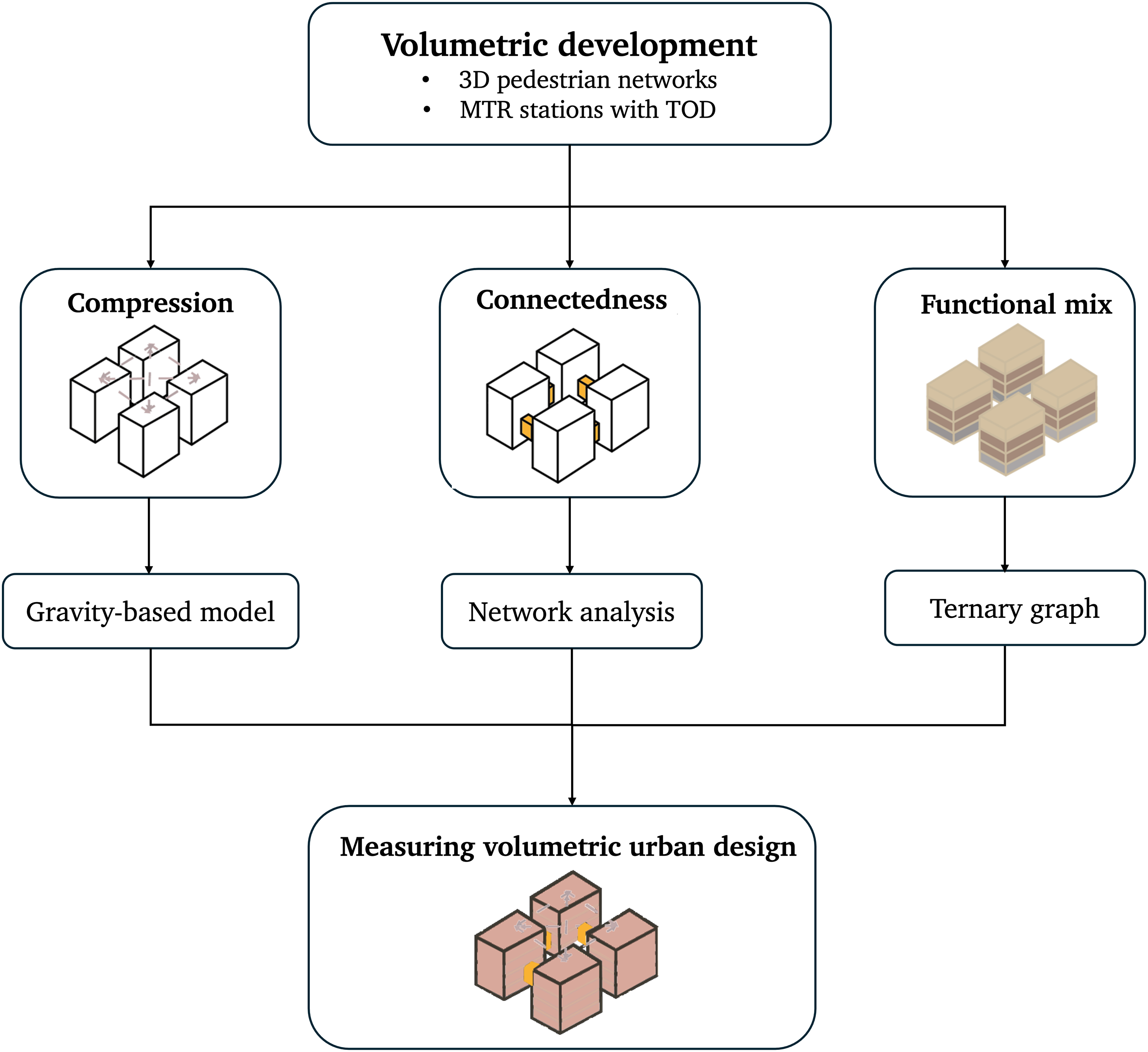
Method
Hong Kong and the study sites
Hong Kong is a high-density city, with built-up areas exceeding 20,000 people per square kilometre (Census and Statistics Department of Hong Kong, 2024, 2025). Renowned for its TOD practice, the city has over 100 metro stations, with most urban development situated nearby. To develop and test our measures, we selected Central and Tsim Sha Tsui (TST) as study sites (Figure. S1). We aimed to develop operationalisable measures using fine-grained, open-access data to capture volumetric urban design, rather than applying these measures broadly for comparison across multiple areas. Central and TST were chosen as typical cases for their varied historical development, diverse building forms (e.g., from colonial-era structures to modern high-rises on reclaimed land), representative volumetric design (e.g., extension of networks in three dimensions), and the implementation of TOD principles.
Central, located on the northern shore of Hong Kong Island, is the CBD and home to the headquarters of multinational companies. It features the city’s most extensive three-dimensional pedestrian networks, including 8 km of elevated walkways that link Central and Sheung Wan. Served by three metro stations—Central, Hong Kong, and Sheung Wan—with 26 exits and extensive underground networks integrate with property development. The area around Hong Kong Station, developed in the 1990s, was renowned for its property development, incorporating TOD concepts. Central exemplifies high-density, volumetric urban design characterised by dense, multi-functional developments and multi-layered pedestrian connections.
Tsim Sha Tsui, located at the tip of the Kowloon Peninsula, is a major tourist and commercial hub known for its shops, hotels, and restaurants. The area has two metro stations (TST and TST East) with 26 exits, facilitating seamless transfers between the stations and surrounding destinations. Extensive underground pedestrian networks, developed alongside commercial growth and subsequently expanded by private developers, facilitate pedestrian movement underground (Zacharias and He, 2018). Recent projects near TST East station, such as Victoria Dockside, follow TOD principles and exemplify multi-functional, high-density urban design.
Dataset and processing
The workflow of this study is shown in Figure 2. We collected POI data from Gaode Map, which offers more comprehensive coverage of geographical entities in Hong Kong than official or other third-party sources. Data accuracy was verified by randomly sampling POIs and cross-checking with field observations and alternative datasets (e.g., Google and Foursquare). The Gaode dataset comprises 23 major categories, with each POI containing its longitude, latitude, and exact floor level. POI categories located outside buildings (e.g., parking, transportation) were excluded, resulting in 10 retained categories for analysis (e.g., catering, hotels, and tourist attractions). To address positional inaccuracies, we manually corrected deviated POIs to ensure alignment with building footprints. Data processing.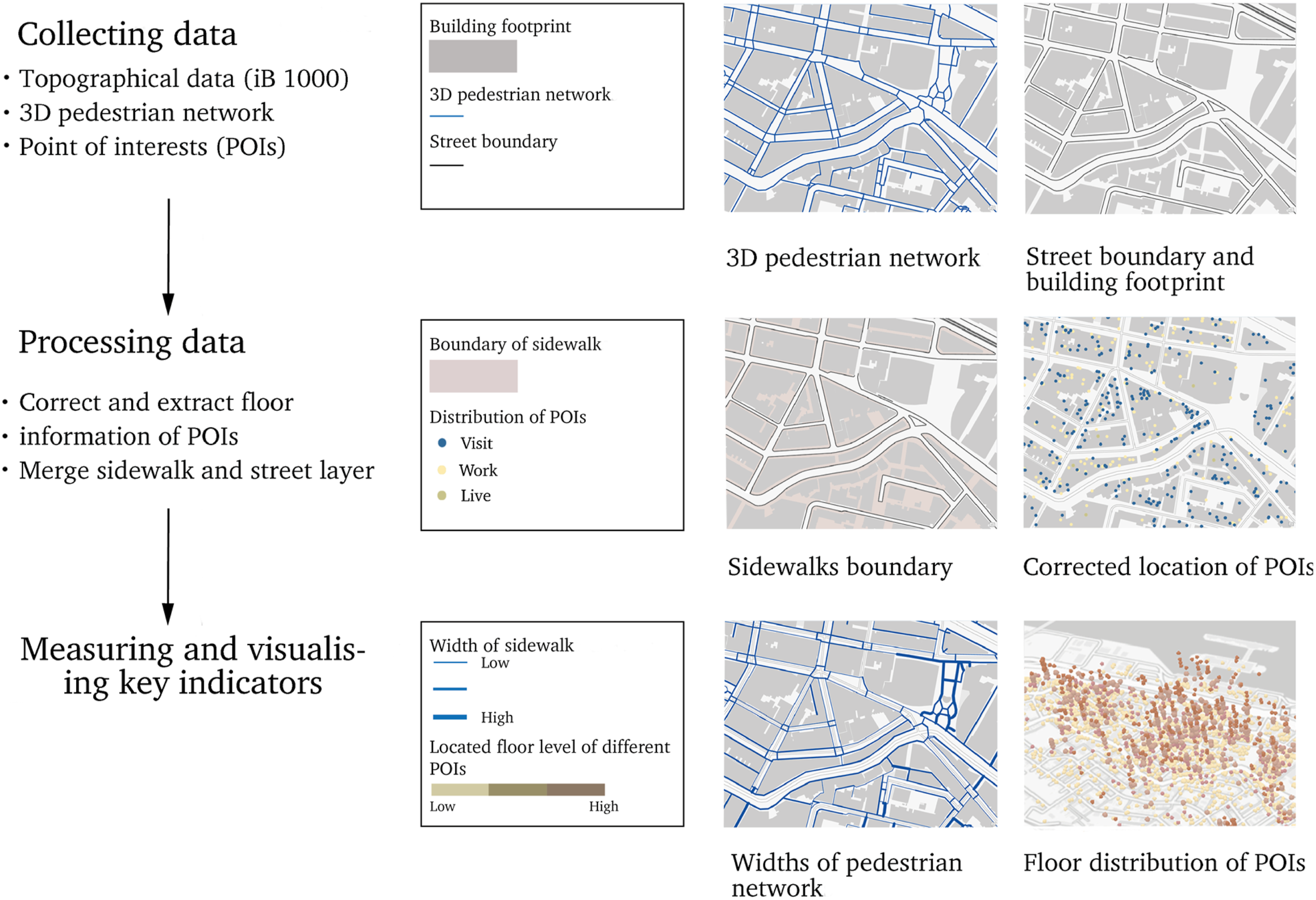
We used two primary data sources to map multi-level pedestrian networks. First, we drew on a comprehensive geodatabase of Hong Kong’s three-dimensional pedestrian networks (Sun et al., 2021), which classifies 23 types of pedestrian paths into three height levels: ground-level sidewalks (Level 0), underground paths (Levels L3–L1, for example, metro concourses), and elevated walkways (Levels 1–2, e.g., footbridges, interior public pathways). This open-access dataset notably includes interior pedestrian networks with public access, such as privately owned public spaces within podiums and atria. Second, the Hong Kong Lands Department’s iB1000 topographic dataset provided detailed street information, including building boundaries, motorised lanes, and outdoor sidewalks (e.g., stairs, alleyways, and footbridges), as well as building footprints and heights. Building complexes with low-rise podiums and high-rise towers are common in Hong Kong, and the iB1000 dataset captures these forms in detail. We estimated the number of building floors by dividing building height by an average floor height of 3.4 m (Li and Tsang, 2008).
Data processing was involved in several steps. First, sidewalk boundaries were identified, and sidewalk widths were manually extracted in GIS based on street boundaries and building footprints. Since widths vary along each segment, we used the narrowest point to represent the minimum pedestrian movement capacity for each segment. For pedestrian network types not captured in the datasets, such as indoor, underground segments, and crossings, we referenced Hong Kong’s design criteria for width assessment (Table S2). Second, floor information was extracted from POI address text using Python, allowing each POI to be assigned to a specific floor. Descriptive statistics are provided in Table S3.
Measures for volumetric urban design
Compression
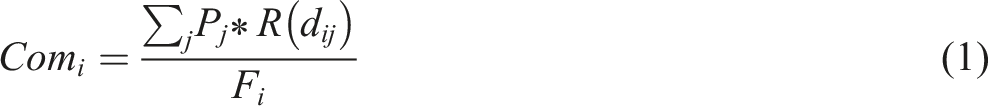
Compression was defined as the aggregated interaction opportunities between a building and its nearby buildings, mediated by multi-level pedestrian networks and accounting for distance decay. We applied a gravity-based model, commonly used to measure spatial interactions (Thill et al., 2011). In our model, the number of POIs is weighted to reflect the interaction opportunity and attraction between buildings. The compression level for each building was calculated as the number of POIs divided by building floors, reflecting the assumption that a higher density of POIs within fewer floors indicates greater functional intensity and economic activity. Spatial impedance was measured along three-dimensional pedestrian networks, using a negative-exponential specification to calibrate walking trips (Kwan, 1998). The compression level of a location

Connectedness
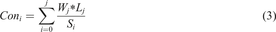
We defined connectedness as the indicator measuring the public interface that can be reached within walking distance from each building. The measure is a proxy for the walkable and permeable interface that pedestrians encounter. The calculation refers to the aggregation of walkable space of different street segments in catchment areas; a higher score indicates that a larger street space accommodates pedestrians. The walkable space of each segment is the length of each street segment multiplied by its width. We calculate the catchment area of the location
Edge effect in this study could arise from two sources. First, natural barriers, such as the sea and country parks, constrain urban expansion, resulting in a lack of built-environment information for areas beyond these boundaries (e.g., waterfront buildings facing the sea). Second, edge effects occur where the study area borders developed regions not included in the dataset, potentially resulting in incomplete information near the boundaries. To address this, we excluded catchment areas that overlapped with unbuilt areas (e.g., sea) and built areas outside the study boundary. Catchment areas for connectedness and compression were defined as 400 m network-based distances from each building centroid, reflecting the typical walking distance preferred by Hong Kong residents (Audi et al., 2010).
Functional mix
We assessed the functional mix of each building across three categories—live, visit, and work—using a ternary graph (Dovey and Pafka, 2017), which graphically represents the composition of three variables in a two-dimensional triangle. Each point’s position on the plot corresponds to its trilinear (barycentric) coordinates, enabling intuitive visualisation of functional composition. Functional mix was interpreted using the parallel line method, where lines parallel to each triangle edge indicate constant values for the corresponding function at each vertex. Each component is 100% at its vertex and decreases linearly to 0% at the opposite side. Based on these coordinates, we classified buildings into 100 functional mix levels. Buildings located on the triangle’s edges were considered mono-functional (pure live, work, or visit). In this study, “live” refers to residential estates and hotels; “work” encompasses business, office, government, institutional, educational, and financial uses; and “visit” includes catering, daily services, retail, healthcare, and sports and leisure facilities.
We developed two building-level functional mix indicators: overall and vertical functional mix. The overall functional mix captured all POIs within a building, while the vertical functional mix focused on POIs located above the ground floor. This distinction is important, as upper floors in Hong Kong’s city centre are frequently used for non-residential functions and are connected by decks or bridges (Shelton et al., 2013). For the vertical mix, housing-floor POIs were identified using POI data, supplemented with online sources and site surveys. Using the ternary plot, we visualised the functional mix levels for each building, categorising both overall and vertical functions as live, work, or visit. A building was classified as “mixed” if it contained POIs from more than one category; otherwise, it was mono-functional, shown in black. Notably, these indicators reflect the functional diversity within buildings, rather than the intensity of use.
Evaluating the volumetric design measures
Comparing with two-dimensional measures
We need to know how proposed measures outperform two-dimensional indicators and work as benchmarks in representing volumetric urban design. The intensity of compression, connectedness, and functional mix depends on capturing three-dimensional information, such as multi-level networks and floor-based information (e.g., networks, building floors, and floor-level functions). We examine the measures with and without three-dimensional information (e.g., ground-floor networks, building footprint, and mono-functional building) on the study sites. Examining the change in the measures can verify the bias of two-dimensional measures.
What-if scenario analysis
We conducted a what-if scenario analysis for a site in the Central area, connected by elevated walkways, to examine the impacts on volumetric design outcomes. Specifically, we evaluated changes in connectedness if the elevated pedestrian network were removed. We also assessed how elevated walkways influence compression by supporting additional interactions above ground. For the functional mix, we analysed whether elevated walkways create an additional “ground floor” for pedestrians, thereby altering the vertical functional arrangement of buildings.
Noted functional mix operates at multiple scales. The elevated walkways would provide sheltered, separated pedestrian routes, connecting individual buildings to larger complexes. As a result, a building’s functional mix may reflect the functions of adjacent connected structures. To investigate this, we examined how elevated walkways redefine the multi-scale functional mix by linking neighbouring buildings. The analysis involved two steps: first, we grouped directly connected buildings (e.g., atrium, podium, and tower) as single complexes. Second, we calculated each building’s function mix by incorporating a weighted average of the functions of nearby buildings connected via walkways within a 50-m radius. For example, if a building was linked to two others, its functional mix was determined by the average of all three buildings’ functions.
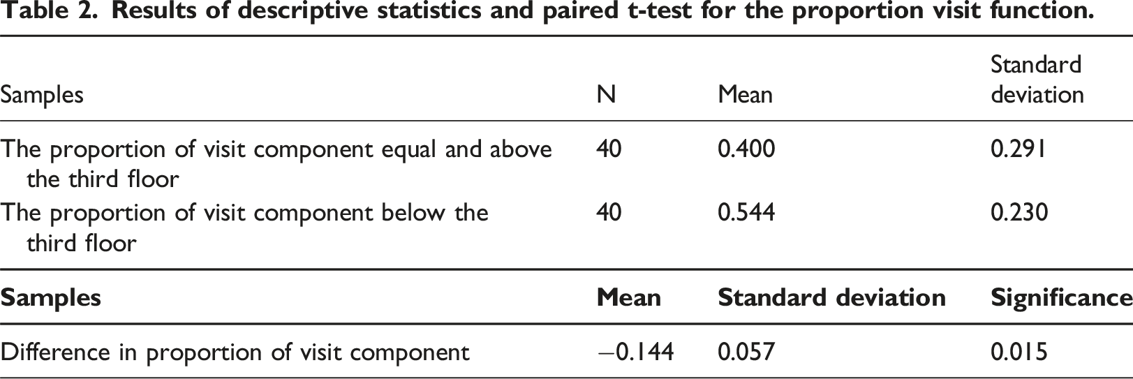
Additionally, t-tests were used to compare the proportion of visit-related functions on floors connected by walkways (below the third floor) with those on higher floors within the same buildings. Paired t-tests assessed how multi-level pedestrian networks influenced vertical functional variation by comparing functional components across different floors.
Results
Volumetric design measures
Compression
Figure 3 (a) and (c) illustrate the compression levels in the Central and TST areas. In Central, building compression ranged from 0 to 100.25. High compression was clustered in the western coastal zone; the mid-levels (shown in the southern part of the figure) exhibited lower compression, likely due to the predominant residential use. The eastern side also showed low compression, possibly due to the presence of large, single-owner buildings, such as public institutions and government buildings. Areas of high compression roughly corresponded with metro stations, reflecting the long-standing clustering of high-intensity commercial buildings and office towers in Hong Kong’s CBD. Visualisation of compression and connectedness in the study areas: (a) Compression in Central area; (b) Compression in TST area; (c) Connectedness in Central area; and (d) Connectedness in TST area.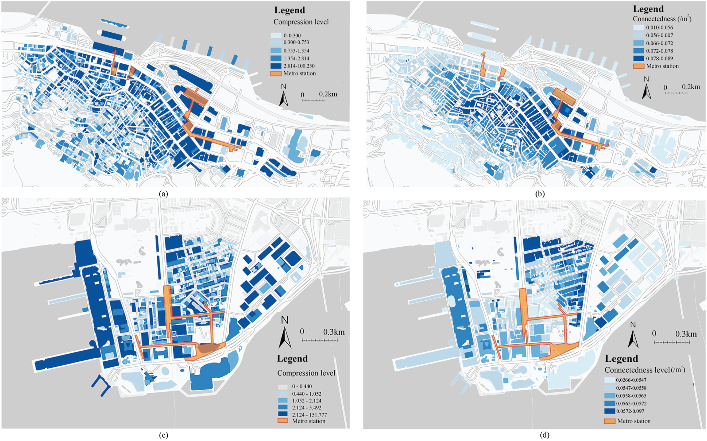
Compression levels in TST ranged from 0 to 151.77. Higher compression was observed in the northern regions, whereas the southern and coastal areas exhibited lower levels. This pattern is likely due to lower building density and fewer connections in coastal areas, which reduce opportunities for interaction between buildings. Notably, highly compressed zones in TST did not correspond to metro station catchment areas, suggesting no clear alignment between TOD and volumetric intensity in terms of compression within TST.
Connectedness
Figure 3(c) and 3(d) present connectedness levels for Central and TST. In Central, connectedness ranged from 0.01 to 0.09, indicating that 1% to 9% of the spaces around buildings were walkable relative to the total area. The highest connectedness was found in the central core, decreasing outward, likely due to the extensive multi-level pedestrian networks provided by MTR and private developers. Highly connected areas were concentrated around Central Station (located in the east), but not at Sheung Wan Station (located in the west).
TST exhibited a higher connectedness level, ranging from 0.03 to 0.10. High connectedness was clustered in the north, likely due to small block sizes and a dense network of lanes, which together enable diverse pedestrian routes. Outer areas, particularly along the waterfront promenade, exhibited lower connectedness, reflecting limited pedestrian access at the perimeter. Additionally, these highly connected zones did not overlap with the metro station areas.
Functional mix
Descriptive statistics of overall and vertical building-level functions in the study areas.
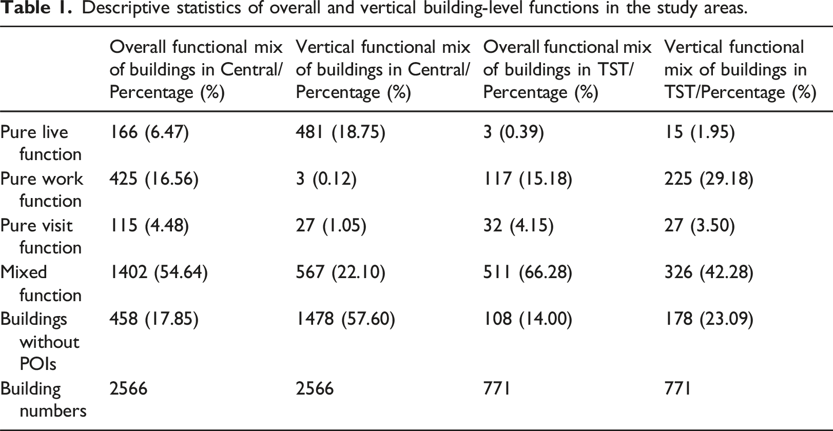
Figure 4 visualises and presents the distribution of building-level overall and vertical functional mix. In Central, the predominant mix was a combination of work and visit functions within the same building, especially in coastal areas, reflecting the concentration of commercial and administrative entities around the harbour. Mixing of residential functions with work or visit uses was less common, with residential buildings primarily located in mid-level areas (in the south). The coastal zone showed a strong work-visit mix, while a visit-live mix was more typical in the mid-level areas. Buildings in the northeast were mostly mono-functional, often due to single ownership by companies or institutions. The overall functional mix level did not correspond with the metro station catchment area. Vertically, mixed-use buildings in Central were mainly concentrated along the coast, whereas buildings in the mid-levels were predominantly mono-functional, with vertical arrangements that were primarily residential. Visualisation of functional mix in the study areas: (a) Ternary graphs of the building overall and vertical functional mix in Central and TST; (b) Building overall functional mix in Central; (c) Building vertical functional mix in Central; (d) Building overall functional mix in TST; and (e) Building vertical functional mix in TST.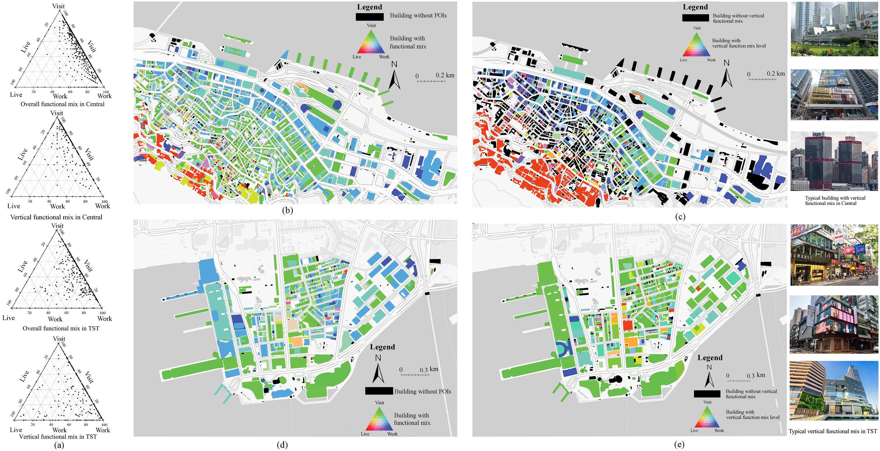
Both overall and vertical functional mixes were more prevalent in TST. Many buildings, integrating high proportions of work and visit functions, exhibit a high degree of functional mix. In a vertical functional mix, visit-related uses are also common on upper floors, alongside residential functions such as hotels and hostels. Thus, the results quantitatively verified the typical podium-tower form characteristic of Hong Kong in TST, with commercial uses at the base and residential uses above. These results visualised the prevalence and distribution of multifunctional buildings. However, the work component was relatively low, likely because retail and commercial activities were primarily clustered to serve the local industry rather than to accommodate office or business uses.
Evaluation of the new measures
Comparison with two-dimensional measures
Figures S2(a) and S3(a) compare and illustrate the compression level based on two-dimensional data. Although the absolute value of compression changed, the relative ranking of compression levels remains stable. It highlighted the effectiveness of well-connected ground-level pedestrian networks in mitigating losses associated with elevated or underground connections, particularly those due to compression. Figures S2(b) and S3(b) illustrate the estimated bias of the connectedness level using two-dimensional information, which only reflects the ground-level networks. We used the same intervals in the visualisation to ensure comparability with the results presented in Section 4.1. The impacted areas cluster around the two metro station areas in Central, with up to 51.51% of the connectedness level unaccounted for (Figure S2(c)). In contrast, the impact on TST was more evenly distributed. Furthermore, the results highlight that the connectedness was relatively low in ground-level networks. Furthermore, Figures S2(d) and S3(d) illustrate the building function based on the land use map. Table S4 presents the building function patterns in the Central area, illustrating the dominant live and visit land uses. However, land use data neglect the extensive presence of mixed-use buildings and overestimate the live function. These highlight that the neglect of nuanced building configurations has led to estimation bias and oversimplified spatial layouts.
Impacts of multi-level pedestrian networks on volumetric design
The “what-if” scenario results provided insights into how multi-level pedestrian networks affect compression, connectedness, and functional mix. We focused on areas in Central areas connected by elevated walkway systems, which constitute one of the largest grade-separated pedestrian systems globally, linking office towers, commercial complexes, metro stations, and privately owned public spaces.
Figure 5(a) shows that elevated walkways significantly enhance compression levels for buildings and their interactions above ground. The spatial impact varied widely, with walkway contributions to building compression ranging from 0% to 91.67%. This demonstrates that elevated walkways function as an additional “ground” level, supporting the vertical stacking and concentration of building activities. Figure 5(b) illustrates changes in connectedness if elevated walkways were absent. The removal of these networks would reduce connectedness by 5.90% to 35.29% in affected buildings, underscoring the critical role of elevated pedestrian infrastructure. Contributions of elevated walkways to volumetric design outcomes: (a) Changes in compression if without elevated walkways; (b) Changes in connectedness if without elevated walkways; (c) Changes in functional mix at the floor level of the buildings connected by elevated walkways.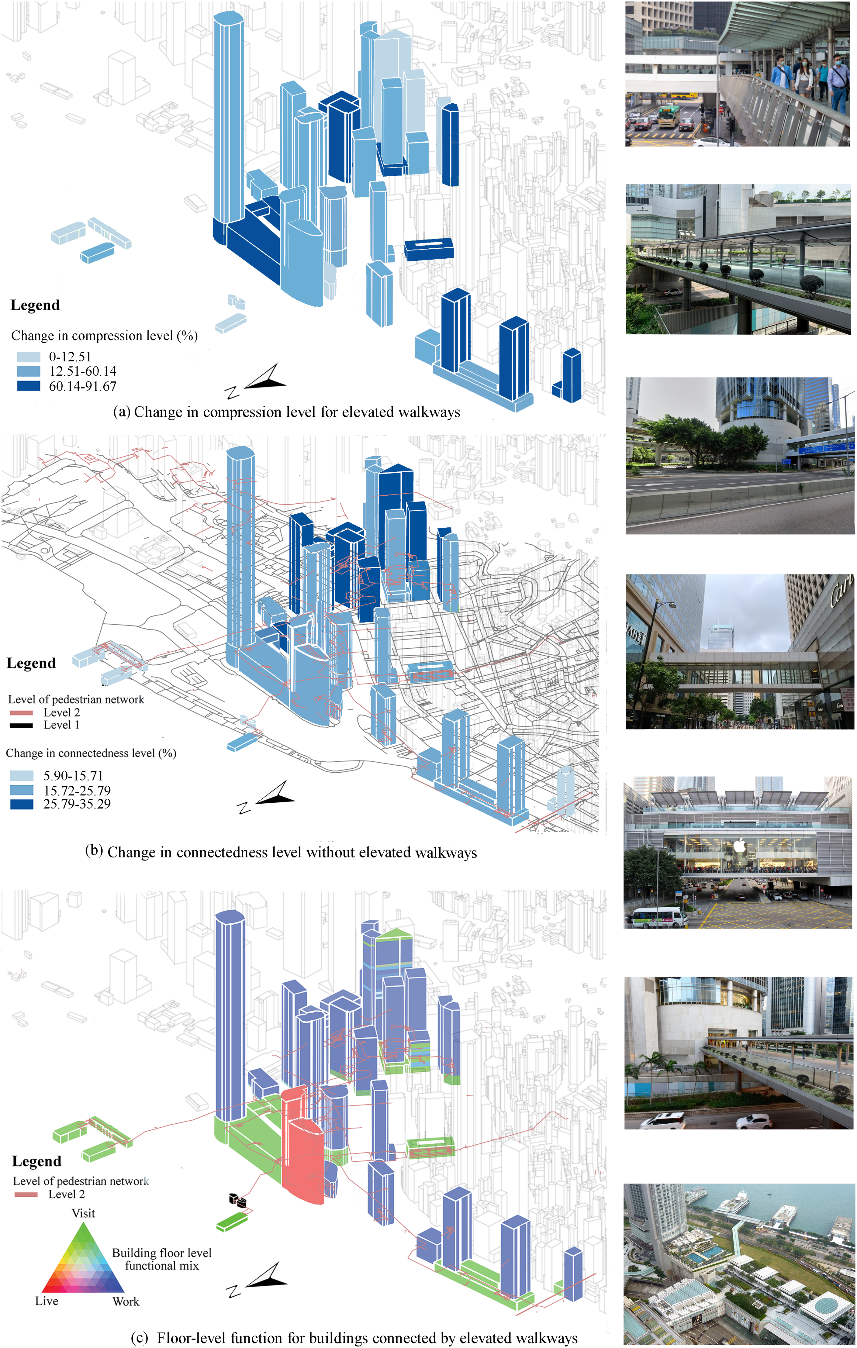
Discussion and conclusion
By developing and applying operationalised methodological frameworks, this study measures three key urban design attributes: compression, connectedness, and functional mix. We deepen the understanding of the unique spatial logic and functional organisation of volumetric urban environments, highlighting vertical zoning and a dense, interconnected urban fabric that are often overlooked by traditional two-dimensional approaches. Overall, our analysis demonstrates that conventional metrics cannot capture the complexity of Hong Kong’s high-density settings, which are characterised by multi-level pedestrian networks and integrated metro stations following TOD principles. These findings underscore the need for new frameworks to guide urban analysis, design, and policy-making in high-density cities shaped by volumetric development.
The compression measure defines the opportunity to access destinations from a given building, including all urban entities reachable via connected pedestrian networks. Our findings reveal how building spaces are organised and interact to activate urban functions in high-density environments. The spatial distribution of compression highlights how building spaces serve as nexuses between spatial form and urban activity, demonstrating how neighbourhoods (i.e., 400-m catchment areas) are functionally organised to form the high-density urban skeleton. Our analysis highlights the crucial role of three-dimensional pedestrian networks in amplifying the urban intensity. Therefore, compression renders a comprehensive proxy for spatial interaction, pedestrian flows, and overall urban vibrancy at a fine-grained scale in volumetric cities.
The combination of permeability and street width determines interface catchments, which, in turn, influence the proportion of public walkable areas. These aggregated catchments define, from a street design perspective, the capacity for pedestrian movement, the extent of the public realm, and urban vitality. In the two case sites, only 1% to 10% of the space relative to catchment areas was open to flexible and efficient pedestrian movement. Given these spatial constraints in dense environments like Hong Kong, expanding street links or ground-level street width is unlikely to be feasible. Instead, multi-layered pedestrian networks—developed by both public and private sectors—have become essential for increasing route options and overall connectedness. In such cases, differences in connectedness levels between catchment areas primarily reflect the extent of vertical network expansions. Multi-level connections diversify routes, improve station interface catchments, and support successful TOD implementation, highlighting the initiatives of planners, designers, and developers in creating privately owned public spaces by overcoming land use constraints.
For functional mix, this study introduces fine-grained measures of both overall and vertical functional mix. The results show that functional mix exceeds 50% of individual buildings, and vertical (above-ground) mix is over 20% buildings, providing strong quantitative evidence of enduring land use and architectural strategies in Hong Kong’s city centre. This scale of functional mix extends beyond single land plots, spanning from colonial-era buildings to modern complexes (Shelton et al., 2013). Such strategies maximise daily service provision within blocks or even single buildings. Our findings visualise the distribution and confirm the prevalence of combined work and visit functions, as reflected in the high concentration of services, shops, and companies within individual buildings. The observed vertical functional mix further illustrates how urban activities and spaces are organised through innovative building typologies (e.g., podiums and atria) and the adaptive reuse of older structures in Hong Kong, facilitated by advances in vertical connections.
In addition to measuring single design indicators, our findings highlight how multi-level pedestrian networks support connectedness, compression, and functional mix in volumetric design. These results are consistent with previous qualitative observations that podium decks serve as new “grounds” for building towers, while footbridges and ramps connect multiple layers to create multi-level environments around station catchment areas (Tan and Ql Xue, 2014). Often realised as privately owned public spaces, multi-level walkways not only expand connectivity and enable denser urban forms, but also enhance the spatial configuration of shopping and service sectors. It was also supported by quantitative evidence that three-dimensional pedestrian networks expand walkability (Zhao et al., 2021). Our study further demonstrates that elevated walkways alter the functional mix at multiple scales by connecting diverse building types—such as atria, podiums, and towers—across different levels. Moreover, pedestrian networks, including underground metro networks, foster integrated urban fabrics characterised by both high volumetric intensity and TOD principles.
This research has several limitations. First, while the use of POIs enabled fine-scale mapping of building functions and supported large-scale analysis, it did not capture the actual attractiveness or use intensity of these destinations. Future studies should consider more detailed datasets that account for variations in size, usage patterns, and amenities. Second, there are limitations in measuring connectedness. Although we included pedestrian network widths, some categories could not be measured due to data constraints, which may affect the accuracy of estimated widths. Additionally, our network-based analysis did not account for travel time friction due to slope in the calculation of connectedness. Finally, POIs do not record the exact locations or entrances within the building footprint. As a result, the compression calculations did not account for actual floor areas or the specific routes from building entrances to POIs, which may introduce bias into analyses and the understanding of spatial interactions.
Our proposed method also has several notable strengths. It challenges conventional approaches to measuring building density, connectivity, and functional mix by responding to the emergence of multi-layered, volumetric urban design strategies. The method enhances understanding of the volumetric urban fabric and demonstrates strong validity. Moreover, although its computational foundation largely builds on existing techniques, the study introduces innovative processing procedures to extract fine-grained information—such as floor-level functions and pedestrian interface catchment areas—thereby extending urban design measures to quantify volumetric cities.
In conclusion, this study examines how multi-layered pedestrian networks and metro stations facilitate pedestrian movement in high-density environments by providing climate-controlled, vehicle-free, safe, and efficient pathways. It further integrates underground metro systems, ground-level spaces, and above-ground developments to enhance the vibrancy of volumetric urban environments. Although the empirical analysis focuses on Hong Kong, the study engages with broader practices of volumetric urban design and offers insights relevant to other high-density cities. As urban environments become increasingly multi-layered and complex, both data and analytical methods must move beyond the limitations of conventional two-dimensional measures. The framework developed in this study enables comparative analyses of volumetric urban design and can be applied across high-density contexts, supporting cross-city comparison and the systematic assessment of economic, social, and urban form outcomes in future research.
Supplemental material
Supplemental material - Measuring volumetric urban design: Compression, multi-level connectedness, and functional mix in transit-oriented developments in Hong Kong
Supplemental material for Measuring volumetric urban design: Compression, multi-level connectedness, and functional mix in transit-oriented developments in Hong Kong by Dongsheng He, Guibo Sun in Environment and Planning B: Urban Analytics and City Science.
Footnotes
Acknowledgement
The authors would like to express thanks to the assistance from Mr Xinyi Li and Mr Qihang Zhang for collecting data.
Author contributions
Funding
This study was partially supported by NSFC (No. 52078446). The funder had no role in study design, data collection and analysis, decision to publish, or preparation of the manuscript.
Declaration of conflicting interests
The authors declared no potential conflicts of interest with respect to the research, authorship, and/or publication of this article.
Data Availability Statement
The datasets generated and analysed during the current study are available on request.
Supplemental material
Supplemental material for this article is available online.
Author biographies
References
Supplementary Material
Please find the following supplemental material available below.
For Open Access articles published under a Creative Commons License, all supplemental material carries the same license as the article it is associated with.
For non-Open Access articles published, all supplemental material carries a non-exclusive license, and permission requests for re-use of supplemental material or any part of supplemental material shall be sent directly to the copyright owner as specified in the copyright notice associated with the article.