
Abstract
The concept of the 15-minute city has gained a lot of popularity in recent years. Numerous studies have looked at a wide variety of cities, providing insights into the extent to which the 15-min-city has been achieved, or the specific x-minuteness that has been achieved so far. In a context of competition between cities in terms of quality of life and sustainability, statements about their performance in terms of x-minuteness dominate. However, to date there has been no research on the quantitative measurement and comparison of x-minuteness for different urban structure types. Urban structure types are defined by specific combinations of characteristics of the built environment. In this study, the pedestrian x-minuteness is computed for the fifteen most populated cities in Germany and compared across six characteristic urban structure types. The results underline that pedestrian accessibility varies greatly based on different urban structural types and that it is important to look more closely at the spatial composition of cities at the neighbourhood level. This spatially differentiated information helps to target improvements more efficiently and, thus, to increase quality of life more equitably.
Introduction
Cities are dynamic places and their spatial structure tends to change over time, which affects the morphology of a city (Conzen, 1960; Kostof, 1991, 1992). The different building materials, phases of construction and urban planning paradigms are reflected in a variety of spatial structures (Anas et al., 1997). The result is that today’s cities consist of a mixture of different urban structure types, which are reflected in the different characters of urban neighbourhoods. These are characterised by varying degrees of density, street layout and various building morphologies, among other aspects (Conzen, 1960; Kostof, 1991). For example, historic old towns in European cities are characterised by very high building densities (Wurm et al., 2021), or modern central business districts with skyscrapers (Taubenböck et al., 2013), while another extreme are the low-density suburban areas with single-family homes and private gardens (Taubenböck et al., 2015).
For Western European cities, the spatial distribution of the urban structures often follows some recurring patterns that reflect the historical development of cities (Braunfels, 1976; Conzen, 1960; Kostof, 1991, 1992). The city centre is typically of medieval or Renaissance origin, with a very dense network of streets and historic buildings. Rapid population growth and urbanisation in the industrial era led to the development of new areas surrounding the old centre (e.g. perimeter block development) (Sonne, 2009). With the housing shortage after the Second World War, other types of urban structure, such as large-housing estates (Köberl et al., 2024) and elongated apartment blocks, were also often located on the outskirts of the historical city (Schröteler-von Brandt, 2014). This has been accompanied by a process of suburbanisation, with a predominance of single-family homes (Jetzkowitz et al., 2007).
The era of transportation and the era of morphology go hand in hand: while morphologies from the pre-automobile era are known to be highly compact, having a high functional mix and a dense street network which enable pedestrian flow and are transit-oriented, morphologies that emerged in the automobile-dependent era are known to have low density, to have functional segregation and to be dispersed (e.g. Banister, 2005; Cervero, 1998; Newman and Kenworthy, 1999). Thus, these historical developments and their legacy still shape our travel behaviours of today (Newman and Kenworthy, 1999).
The development and urban structure of cities is not only based on historical processes but is also shaped by the urban planning paradigms of each era (Debray et al., 2023). An example is the need for proximity of work, living and leisure facilities, and a high functional mix to create vibrant and lively cities that do not only enhance the quality of life, but also promote social interaction and sustainability (e.g. Gehl, 2010; Jacobs, 1961). An urban planning principle that also favours proximity at the local scale and that has emerged in the last decade, with the prospect of generating more sustainable cities, is the ‘15-Minute City’ (Moreno et al., 2021). The general idea is that residents should be able to access facilities to meet their daily needs at the local scale in less than 15 min, either by walking or cycling (Moreno et al., 2021). Although it is not a new urban planning principle per se, it was popularised with the onset of the COVID-19 pandemic by the Mayor of Paris. She called for the implementation of the 15-minute City as part of the ‘living smart city’ (Allam et al., 2022).
Since then, the concept has gained popularity not only in urban planning practice, but also in research. There are two main strands of research: (1) reviews, critiques and comments on the concept (e.g. Allam et al., 2022; Khavarian-Garmsir et al., 2023; Mouratidis, 2024; Papadopoulos et al., 2023; Pozoukidou and Angelidou, 2022; Pozoukidou and Chatziyiannaki, 2021; Staricco, 2024; Teixeira et al., 2024) and (2) geographical evaluations of the concept using spatial analysis (e.g. Bartzokas-Tsiompras and Bakogiannis, 2023; Bruno et al., 2024; Chen et al., 2024; Ferrer-Ortiz et al., 2022; Logan et al., 2022; Staricco, 2022; Willberg et al., 2023). For the latter, studies that use a fixed time threshold such as 10 or 15 min (e.g. Bartzokas-Tsiompras and Bakogiannis, 2023; Ferrer-Ortiz et al., 2022; Knap, 2022; Staricco, 2022; Weng et al., 2019) have to deal with the ‘edge-effect’ (Gao et al., 2017). Once the threshold is exceeded, even by 1 s, the target defined in the timeframe is considered not to have been met, which fails to capture the continuity of gradients in accessibility to amenities. Any subsequent characterisation of accessibility based on this binary classification has critical limitations. Staricco (2022) showed how a one-minute change in the threshold changed the proportion of the population with access to specific amenities by up to 5–6%. Therefore, Logan et al. (2022) proposed to assess the x in the ‘x-minute city’ to establish a baseline that can help develop and implement concrete urban planning recommendations, based on the actual performance of a given area. This has been implemented in previous studies (e.g. Bruno et al., 2024), including the study by Logan et al. (2022) itself, with the core statement that a city or region has a certain x-minuteness. For example, Berlin is on average an 8-minute city and Sydney is on average a 19-minute city (Bruno et al., 2024). Both studies developed a web-portal where the results are displayed in maps. Bruno et al. (2024) show their results on a hexagonal grid with a resolution of 200 m side length and Logan et al. (2022) for statistical areas. With this, intra-urban variation of the x-minuteness as well as differences in accessibility for different amenity categories can be assessed. Further, results of studies like those of Ferrer-Ortiz et al. (2022), Graells-Garrido et al. (2021), Knap et al. (2023) and Pereira (2019) also make intra-urban variation visible and show that there is a clear tendency of an urban-peripheral gradient for different aspects that determine and influence the x-minuteness. Additionally, recent studies like Zhang et al. (2025), using mobile phone data, and Megahed et al., (2025) show that there is a clear trend of lower x-minuteness in highly dense urban core areas due to higher amenity-variation in comparison to other more peripheral urban morphologies.
A conceptualisation of how the built environment influences the travel behaviour, and thus also the walkability and accessibility of an area, has been conducted by Cervero and Kockelman (1997) where they introduced the model of the 3Ds (density, diversity and design). This model has been expanded by the works of Ewing et al. (2009) and Ewing and Cervero (2001), where two additional Ds that affect travel behaviour, namely, destination accessibility and distance to transit, have been added. In terms of how the morphological configuration of urban areas affects walkability, a recent study by Dovey and Pafka (2020) proposed the urban DMA (density, mix and access) model. They explain the impact and role of each factor to generate areas of high walkability but clearly state that it is their interlinking that is determinant for a good walkability.
Hence, the literature shows that there are clear core dimensions of the built environment like density, diversity and design that influence travel behaviour. In an urban setting these dimensions are rarely randomly occurring, but these factors are often combined in some spatial configurations that exhibit specific characteristics. These are for example represented in building density, the functional mix and the street design, which represent certain planning paradigms and construction periods (see Conzen (1960) and Kostof (1991, 1992)). Those recurring patterns of typified representations of the built environment are often referred to as urban structure types, such as large-housing estates, single-family home areas or old town centres. As has been stated before, the different aspects that constitute the urban structural types are known to influence travel behaviour (e.g. Banister, 2005; Newman and Kenworthy 1999), and thus, it is to be assumed that different, distinctive, urban structural types also exhibit distinct accessibility profiles.
Studies by Majic and Pafka (2019) and Pafka and Dovey (2017) compare the differences in walkable access, based on permeability and interface catchment, for different urban morphologies. A study by Burke et al. (2022) found that urban typologies within cities that have a certain degree of fractality are more likely to be classified as 15-minute cities. Additionally, a study by Droin et al. (2024) shows that pedestrian permeability varies significantly with respect to the underlying urban morphology, and Köberl et al. (2024) show that accessibility and walkability vary greatly depending on the different planning paradigms of large-housing estates. These findings suggest that urban structure types play a significant role in the proximity/accessibility of amenities to pedestrians. All urban structure types have been designed/built to meet specific needs and therefore have specific characteristics. For example, a city that is predominantly motorised, with a sparse pedestrian network and scattered amenities, is more likely to result in a high x-minuteness, compared to a city that is mainly composed of a very dense pedestrian network and a high and dense functional mix. However, we are not aware of any research that has explicitly examined and quantified the pedestrian accessibility for different urban structure types on a larger scale.
Thus, it is the aim of the present study to get a better understanding of how the evolution of the built environment through different transport and planning eras, depicted in urban structural types, has affected the accessibility of today. Therefore, we analyse the concept of x-minuteness by using six clearly distinctive different urban structure types in the 15 largest cities in Germany to quantify the variation of the x-minuteness for these respective different urban structure types. Furthermore, we evaluate some reported pitfalls (quantity versus sufficiency) (Mouratidis, 2024) by investigating aspects such as the number of amenities included in the calculation of x-minuteness for different urban structure types.
Data and methodology
In order to assess how x-minuteness varies based on the underlying urban structure types (UST), we relate to six different USTs that are spatially consistent and that are representative for German cities (see Figure 1) (e.g. Braunfels, 1976; Kostof, 1992; Walde et al., 2013; Wurm et al., 2009, 2016). Further, they are clearly identifiable based on their spatial characteristics and are occurring often enough to attain a stable sample size. Other UST, such as old village centres that have been incorporated into cities due to suburbanisation processes, are hard to delineate. This is because they morph into the surrounding area and have often been considerably altered. They also mainly occur in bigger cities, such as Berlin and Munich. The spatial layout, and thus the morphology, of these six types clearly represent different historical eras of the built environment and of transportation and have distinct characteristics: Old town centre – with mixed historical development (OTC) (see Figure 1, column 1): Often dating back to the Middle Ages or the Renaissance (∼9th–17th century), this type of urban structure is characterised by a dense network of (pedestrian) streets and is mainly representative as the core of the city nowadays (Dickinson, 1945; Kostof, 1991). However, due to the course of history these areas have often been morphologically and structurally altered. Nevertheless the general morphological layout is mostly still visible today as reconstruction was often still impacted by former footprints and streets (Diefendorf, 1989). They are characterized by a high functional mix. Perimeter block development (PBD) (see Figure 1, column 2): The rapid growth of German cities during the industrialisation of the 19th and early 20th centuries led to the construction of new urban neighbourhoods in the form of perimeter block development, adjacent to the old town centres. These are multi-storey buildings (at least 3 storeys) built on the edge of urban blocks of varying size with either a common courtyard in the centre or with buildings (Kostof, 1991; Sonne, 2009). Commercial and residential functions are integrated, with residential functions being mainly concentrated on the upper floors. Elongated buildings (EB) (see Figure 1, column 3): A common type of housing in Germany that boomed after the Second World War to provide quick, affordable housing for a wide range of people. They are usually elongated multi-storey (at least 3 storeys) buildings, often aligned parallel to the street and to themselves and mainly located on the outskirts of a city (Schröteler-von Brandt, 2014). The primary function of this structure is residential, with other functions being underrepresented. Large-housing estates (LHE) (see Figure 1, column 4): Extensive, multi-storey, high-density housing estates, often built of prefabricated concrete slabs. They are a common type of urban structure, especially in East Germany, to address the housing shortage of the 1960s to 1980s (Mau, 2019). Even though less frequent, prominent examples of this UST can also be found in West Germany. A road network is built around the estates, with many pedestrian routes between them (Reicher, 2017; Schröteler-von Brandt, 2014; Urban, 2018). The primary function of this structure is residential. Terraced houses (TH) (see Figure 1, column 5): This type of urban structure consists of a row of houses that share their side walls. They are usually 2–3 storeys high and have private gardens in the back. Although this type of urban structure was very common for industrial workers in the 19th century, in the 1970s and 1980s this type of housing regained attention as affordable housing in suburban areas. The urban blocks that contain this type of urban structure are usually quite long with a relatively sparse street network (Reicher, 2017). The primary function of this structure is residential. Single-family homes (SFH) (see Figure 1, column 6): The prosperous economic development after the Second World War and the demand for housing led to a rapid expansion of suburban Single-family homes. These are generally detached or semi-detached houses, rarely more than two storeys high, with private gardens, located mainly on the outskirts of a city. The road network is sparse and building blocks are generally large without passageways (Kostof, 1991; Reicher, 2017). The primary function of this structure is residential. Exemplary footprint (black) and street (grey) layout (row 1), satellite images (row 2) and street view (row 3) of the six UST. Data source: Building footprints (BKG, 2023); Street network (©OSM); Satellite images (Map data ©2015 Google); Own images.
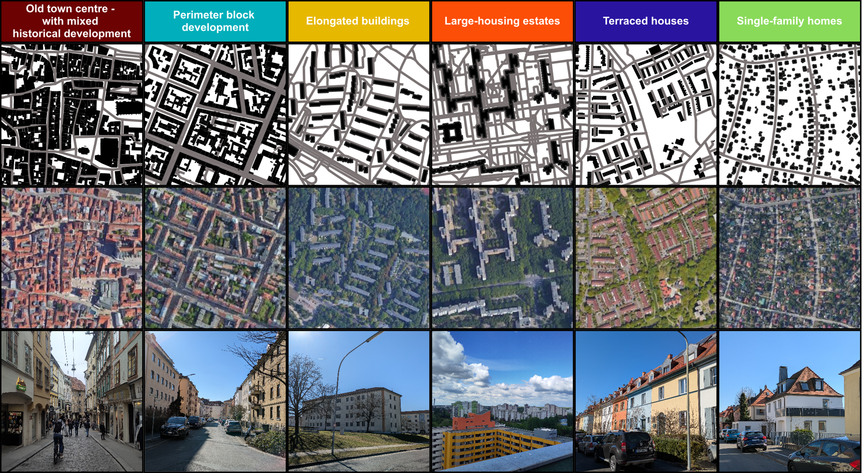
Within the 15 cities under investigation (Berlin (BE), Hamburg (HH), Munich (M), Cologne (K), Frankfurt am Main (F), Stuttgart (S), Düsseldorf (D), Leipzig (L), Dortmund (DO), Essen (E), Bremen (HB), Dresden (DD), Hannover (H), Nuremberg (N) and Duisburg (DU)), we mapped areas where the defined UST were clearly distinguishable from their surroundings at a scale of 1:3000. A total of 2504 polygons (∼237 km2 in total) were mapped while for each structural type at least three samples were mapped per city (with the exception of Old town centre – with mixed historical development, which were mapped using one single large polygon representing the central historic area of the city). Descriptive statistics about the mapped UST and respective maps for each city can be found in the Supplemental Material.
Amenities which serve as destination points.
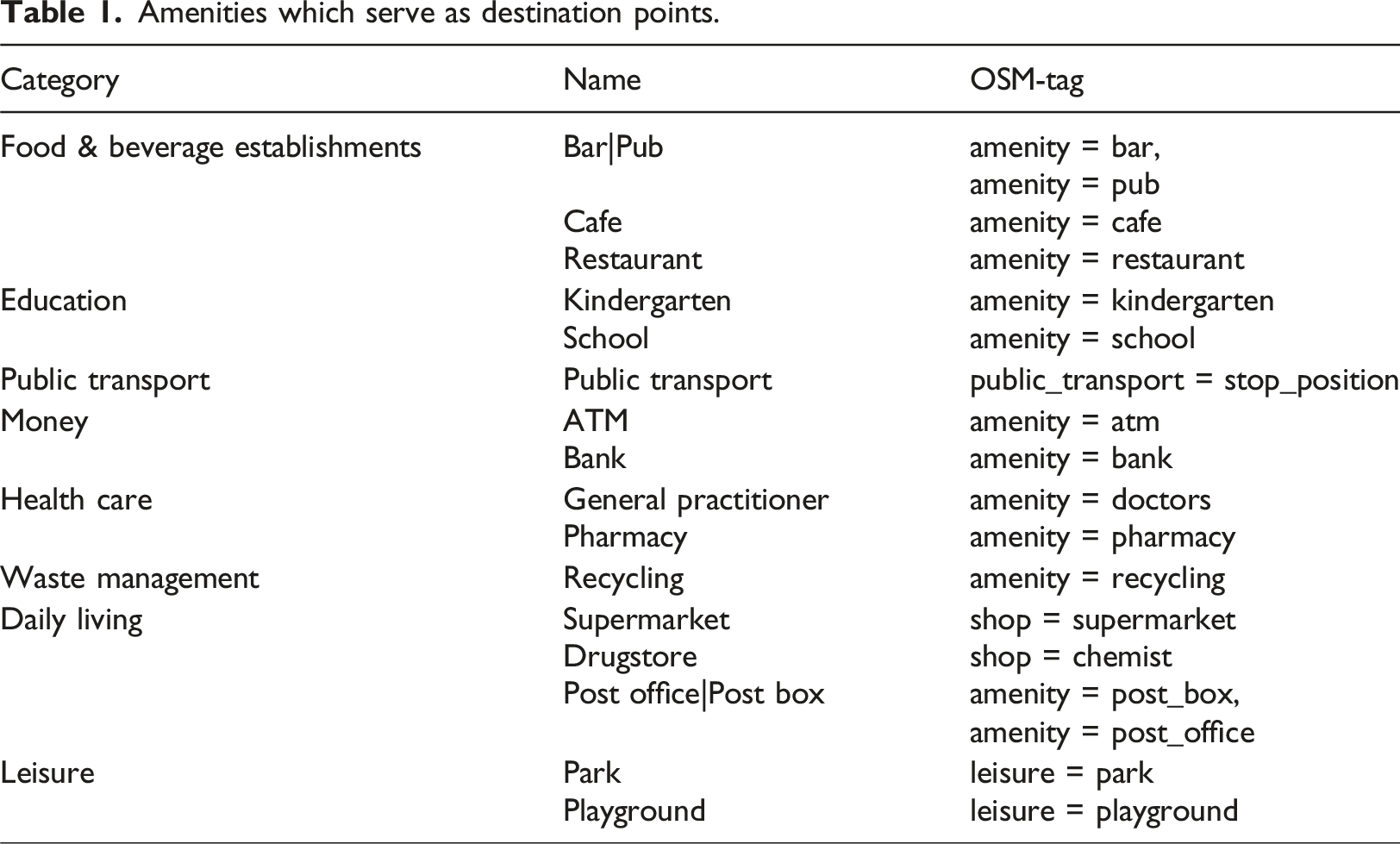
The starting points were derived from building polygons in the OSM database with small buildings such as garages being removed. This resulted in a total of 238,088 starting points for our analysis. The r5 algorithm using the r5r package in R (version 2.0) (Pereira et al., 2021) was used for routing. Walking was selected as mode of transportation, with a walking speed of 4.5 km/h (Schimpl et al., 2011). Travel time to all destination points is calculated for each starting point, respectively. A maximum threshold of 60 min has been set. Thus, if a destination is further away than 60 min from the starting point, a value of 60 min is allocated for the respective travel time. The x-minute metric for each starting point is then defined as the furthest amenity category of all nearest destination points of the 16 amenity categories. In order to gain a better understanding of the quantitative distribution of the x-minuteness within and across the different USTs, we quantified the share of the amount of starting points that are below a certain x-minute threshold. To assess the statistical significance of difference in the x-minuteness between USTs we used the Cohen’s D Effect size (Cohen, 1992) by a pairwise comparison of the UST. Cohen’s d Effect size describes how strong the differences between two groups are, with values of ≥0.8 indicating a large effect and therefore a meaningful difference between the two groups studied. It is calculated as the following:
For analysing how x-minuteness differs between UST in comparison to between cities, we aggregate the x-minute metric for each group by building the average once for each city per UST and once for each UST per city. To also have statistical validation of these differences, we conducted a linear mixed-effects model using the lme4 package in R (Bates et al., 2015). While the dependent variable was the mean time of x-minuteness, the cities and the UST were set as the random intercept variables. With this we were able to differentiate the variance that is attributable to each grouping factor (UST or city). The model was specified as:
To measure the mean x-minute time needed to reach each amenity per UST, we averaged the calculated x-minute metric from before per amenity category and UST. Furthermore, to give implications about the variability of the x-minuteness we also calculated one standard deviation, which gives insights about where approximately 68% of the values are situated. Subsequently, to have insights about the quantitative distribution of each amenity category near each starting point, we extracted the travel time of all 10 nearest amenities per category for each starting point. We then calculated the mean for all nearest amenities per category for each UST, then for each second nearest amenity per category, and so forth.
Analysis of urban structure and its impact on x-minuteness
In the following we present and discuss the results of the impact of USTs on the x-minuteness.
Cohen’s d Effect size of the x-minuteness for the different USTs.
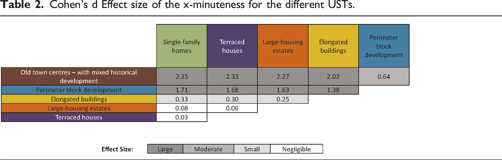
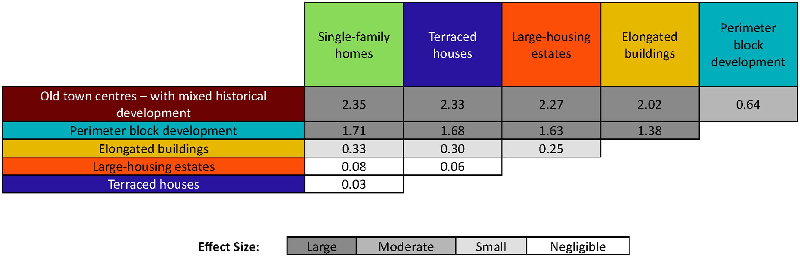
These results show that there are strong variations in x-minuteness between the different USTs. However, this only provides a general overview and insight. Of course, there is also variability within the particular USTs. Figure 2 shows the cumulative share of starting points for each x-minute threshold. The curves for the Old town centre – with mixed historical development and Perimeter block development are quite steep, indicating that a high share of starting points have a low x-minuteness. Within the UST Old town centre – with mixed historical development, there is no starting point that needs more than 25 min to reach all amenities and 50% of the starting points are even within ∼8 min walking time. If we take the planning paradigm of Moreno et al. (2021) and set the threshold at 15 min, the UST Old town centre – with mixed historical development performs well, with a high share of 94% of all starting points below this threshold. This share is also high for Perimeter block development with 71%. All other USTs, however, show less than 12% of the starting points being below the threshold of 15-min. Cumulative proportion of starting points for different x-minute values per UST. Red dashed line shows the 15-min threshold as defined by Moreno et al. (2021).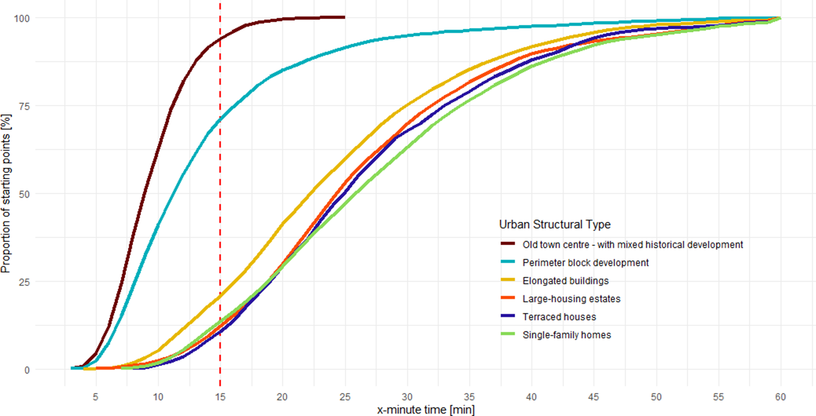
As described above, Old town centre – with mixed historical development – were initially developed when walking was the most common mode of transport, resulting in a very dense road network and proximity to a variety of amenities. Although over time the introduction of motorised transport in cities has often led to an overdevelopment of the road network, the high functional mix of amenities has usually kept these areas at the social heart of the city, offering a wide variety of opportunities. Similarly, in the case of Perimeter block development, even with a sparser street network, the high functional mix in the lower floors, intermixed with residential functions in the upper floors, creates areas with a high accessibility share. The other USTs were mainly built after the Second World War. Here, factors other than pedestrian accessibility and a high functional mix were dominant, resulting in low density, sparse street networks with a prioritisation of motorised transport, zoning and the centralisation of amenities in shopping centres, leading to lower pedestrian accessibility.
Until now, the vast majority of studies that have calculated x-minuteness for different cities have often conveyed their key message such as ‘The city of X is, on average, an x-minute city’ or ‘The city of X achieves the goal of an x-minute city by x%’. This makes generalised assumptions about accessibility within cities and does not take into account the varying spatial patterns that have evolved over time. With our results we provide quantitative values for the intra-urban variation based on the assumption that USTs are ‘packages’ of characteristics of the built environment.
This is also clearly supported by our results in Figure 3, where we looked at two aspects: (1) the average x-minuteness to reach all amenities and (2) we calculated how long it takes on average to reach the nearest amenity of each amenity type. These two aspects are differentiated once by UST and once by city. It can clearly be seen that the variation within each category is much smaller for the differentiation by UST than for the differentiation by city. On the contrary, the variation between the categories is much higher for the differentiation by UST. Additionally, a statistical evaluation of these differences using a linear mixed-effects model clearly underlines this aspect. While urban structure types accounted for ∼83% of the explainable variance, cities only accounted for ∼9% of the explainable variance. The residual variance accounted for ∼8%. Hence, the patterns of x-minuteness are mainly shaped by urban structure types and not by city-level contexts. Thus, it can be concluded that, for example, if a city consists of a large fraction of Old town centre – with mixed historical development the x-minuteness will on average be lower than for a city that has a high share of Single-family homes or Terraced houses. On the left side the points represent the mean time of each city differentiated per UST (15 points per UST), and on the right panel the points represent the mean time of each UST differentiated per city (6 points per city). The upper row depicts the mean x-minuteness, and the red dashed line the 15-min threshold as defined by Moreno et al. (2021). The lower row is the mean time needed to reach the nearest facility of each amenity. OTC = Old town centre – with mixed historical development, PBD = Perimeter block development, EB = Elongated buildings, LHE = Large-housing estates, TH = Terraced houses, SFH = Single-family homes. M = Munich, F = Frankfurt am Main, L = Leipzig, D = Düsseldorf, DD = Dresden, HB = Bremen, K = Cologne, S = Stuttgart, B = Berlin, N = Nuremberg, H = Hannover, E = Essen, DO = Dortmund, DU = Duisburg.
The red dashed line shows the 15-min threshold, as defined by Moreno et al. (2021). When considering the x-minute statistics in the upper row, almost all points are above that line. This means, that especially the USTs Elongated buildings, Large-housing estates, Terraced houses and Single-family homes do, on average, not fulfil the 15-minute city goal.
Even though it is possible to quantify the x-minuteness of a city, we must be careful when interpreting this measure as it can be subject to significant bias. We therefore also interpret the average time needed to reach all nearest amenities (see bottom row of Figure 3). If we take the example of the UST Large-housing estates in the city of Dortmund which has the highest value of average x-minuteness (see Figure 3 top row) with ∼50 min and the second highest average time to all nearest amenities with ∼11 min (see Figure 3 bottom row), we observe a stark difference between these two metrics. This huge discrepancy between the mean and the x-minute statistic shows that outliers can have a huge impact on the metric used. If we only look at the x-minute statistic, one would say that accessibility for Large-housing estates in Dortmund is very poor and that needs to be improved. However, if we take a closer look, we can see that it is only one amenity that is actually not very well accessible for this UST. The results therefore show that it is very important to take a detailed look at the underlying reasons for the value of these metrics. The x-minute statistic should not be taken for granted and valid for all amenities. It provides a general overview of the accessibility of an area but cannot provide insight into the real spatial distribution of the amenities within that x-minute timeframe. If targeted planning practices are to improve the accessibility of an area, it should be considered to take a closer look at the accessibility of the amenities.
Furthermore, as mentioned above, it is important to take a closer look at the accessibility of amenities and not just the overall value of x-minuteness. In Figure 4, the UST of Old town centre – with mixed historical development clearly shows that it has the lowest mean time for all amenities. The similar shape for all the other polygons shows that the amenities are generally distributed similarly, but with varying magnitudes. These results support the findings discussed above. Radar plots with the mean time needed to reach the nearest amenity (full line) as well as one standard deviation per each side (dashed line and filled area) for each UST. OTC = Old town centre – with mixed historical development, PBD = Perimeter block development, EB = Elongated buildings, LHE = Large-housing estates, TH = Terraced houses, SFH = Single-family homes.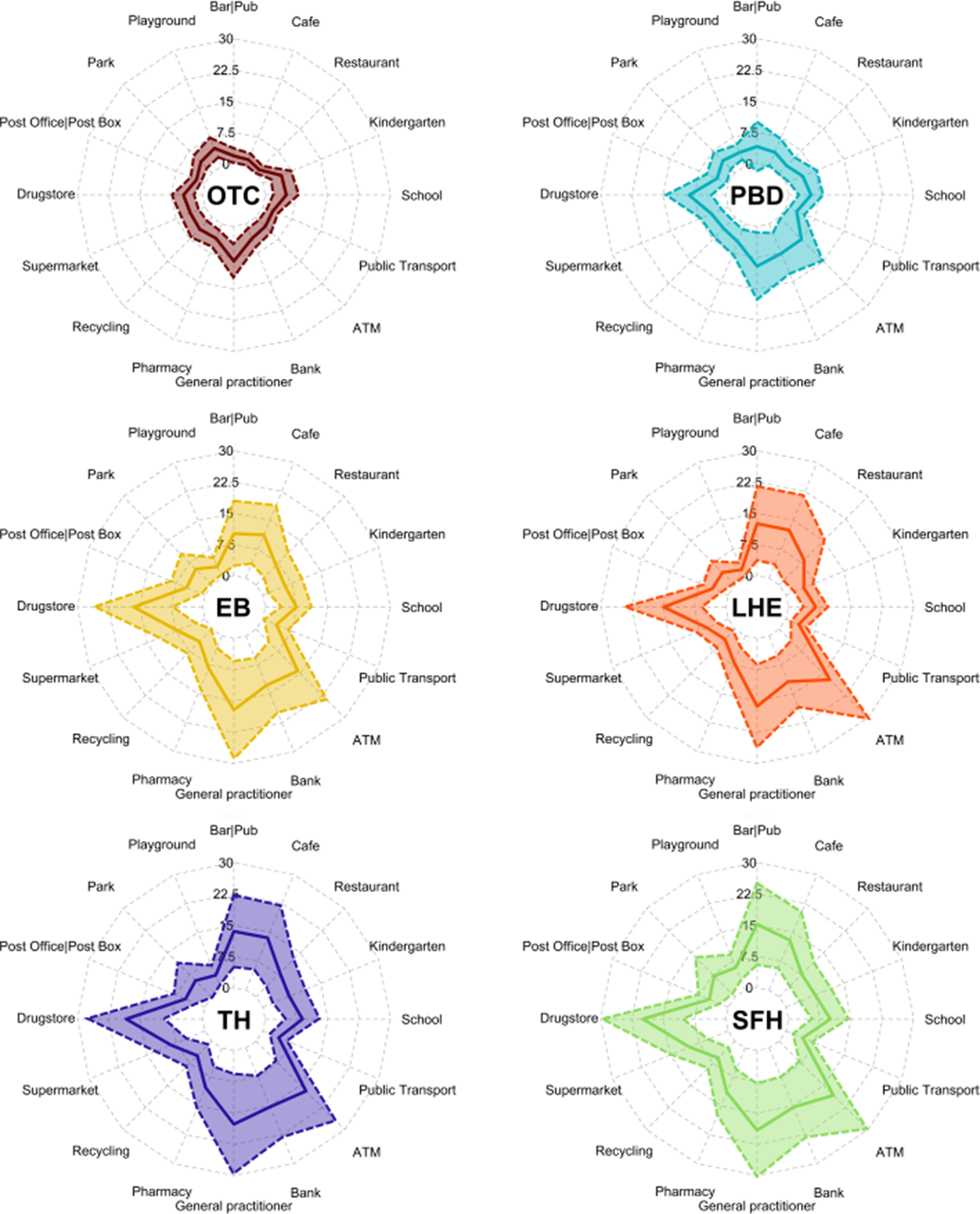
The allocation of the USTs also plays an important role: Perimeter block development is usually the UST that surrounds the inner-city core (Old town centre – with mixed historical development). We can clearly see that there is an overlap in accessibility between these two structure types. In addition to its own relatively good accessibility to amenities, it also benefits from the high functional mix of the inner core. The other USTs tend to be found on the outskirts of the city, so the influence of the Old town centre – with mixed historical development is not as nuanced. With this type of analysis, we can now get a better idea of whether there are enough amenities in a resident’s area. However, how a city is perceived is always highly subjective (see e.g. D’Acci, 2015; Wurm et al., 2021). This is particularly relevant when it comes to the question of which amenities are important to a resident. This must always be considered in context. It should also be noted that this does not give an indication of quality (Mouratidis, 2024): there may be three supermarkets in the near vicinity, but if their quality is poor, people may still drive to a supermarket further away that better meets their standards. Thus, it can be concluded that amenity statistics show similar accessibility patterns between the different UST, but they vary in their magnitude, and hence in the time needed to access them.
It is not possible to measure quality with the GIS analysis performed here. However, we are able to look at quantity. The results in Figure 5 show the time-distribution of the nearest 10 amenities for each amenity type. The shorter and darker the line the smaller the mean time difference between the nearest and the farthest destination point of the given amenity. Generally, as with the results shown in Figures 3 and 4, there is a clear difference between the USTs Old town centre – with mixed historical development and Perimeter block development and the other USTs. Mean time to reach the 10 nearest destination points for each amenity per UST (10 points with the nearest and farthest shown as larger points). Colour denotes the difference in time from the nearest to the 10 farthest amenity for each UST. OTC = Old town centre – with mixed historical development, PBD = Perimeter block development, EB = Elongated buildings, LHE = Large-housing estates, TH = Terraced houses, SFH = Single-family homes.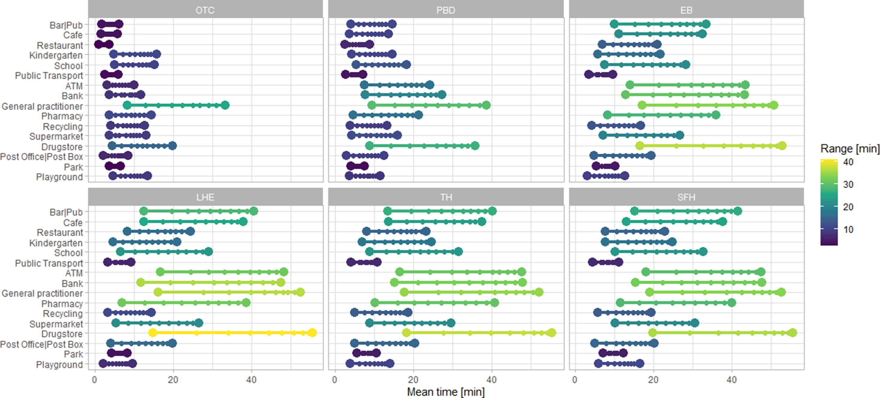
An amenity that is close to the starting points of all USTs is Public transport. From this it can be concluded that, on average, all USTs across German cities have good access to the public transport network. However, this only gives an insight into the spatial availability of bus/tram/underground stops, which seems to be well covered. It should not be forgotten that this does not relate to the temporal availability/frequency of public transport. If an inhabitant lives 100 m away from a bus stop, but it is only served twice a day, the probability of using a private car instead of public transport is very high. We would argue that this aspect is also strongly influenced by the different USTs, due to their historical development. Old town centre – with mixed historical development tend to have a very dense and frequently served public transport network, whereas areas with a majority of Single-family homes are often served much less frequently with sparse connection possibilities.
Limitations
Regarding data limitations, an important point is that we used OSM data for our analysis, which is a dataset created by volunteers, and therefore may not be complete, perfectly accurate or fully up to date. However, it should be noted that the data completeness of OSM data in Germany is quite high (e.g. Brückner et al., 2021; Törnros et al., 2015; Zielstra and Zipf, 2010). This may affect the amenity results, but also the routing is prone to errors due to incomplete or misallocated road networks. We cannot calculate the impact of missing or inconsistent data, but as we conducted our analysis using a large sample, these errors should have a minimal impact on the results of the present analysis.
In terms of methodology, the selected amenities were chosen on the basis of literature and local knowledge but may vary from study to study. We do not claim to be exhaustive, and the choice of amenities may not be consistent with other studies. Our results, however, suggest that the influence of urban structure on accessibility remains the same regardless of the amenities used. It should also be noted that the importance of certain amenities is changing today. The COVID-19 pandemic brought new social norms and patterns that have significantly changed our behaviour and thus our dependence on certain amenities (e.g. paying by card instead of cash reduces the need for ATMs or ordering food at home instead of going to a restaurant). These changes in society should be taken into account when conducting accessibility analysis on a city-wide scale.
For the selected morphologies two points should be considered: First, these are not exhaustive. The aim of the present study is to show that, in general, there is great variation in x-minuteness for the different UST due to their specific characteristics, and not to have a complete set of USTs. Secondly, the selected USTs are broad categories, that may have finer nuanced specific characteristics. For example, Perimeter block development can have varying block sizes and shapes. We are aware of these finer nuances and that they may have an impact on the results, but we argue that using a large sample of 15 different cities compensates for this impact. Furthermore, we are aware that different UST typically occur in different urban locations due to the interplay between the history of urban planning and the dynamic growth of cities (e.g. Conzen, 1960; Taubenböck et al., 2024).
The present study mainly focuses on pedestrian accessibility and does not research accessibility for the bicycling infrastructure or based on public transport, nor for multi-modal accessibility. The reason for that is that we argue that the pedestrian network is the most accurate representation of the urban morphology. An analysis of bicycle and/or public transport already needs additional information about the service infrastructure provided. This is also inherent to each UST, but the aim of this study is to display the impact of morphological aspects on the accessibility.
Finally, we conducted our analysis for the average healthy adult. Walking speed clearly varies at different stages of life. Also, the quality of the street network as well as the ability of the street network to support for example disabled people (e.g. guidelines for the blind or flat areas at the edge of the pavement to the street at crossings for people in wheelchairs) is not considered in this study. In order to produce results that support an equitable society, future studies should take these aspects into account.
Conclusion
With the study at hand, we clearly show that the x-minuteness of an area varies strongly based on the underlying UST. The findings of this study demonstrate that the morphological results of different planning and transportation eras have a clear influence on the pedestrian accessibility. General statements about the average x-minute timeframe of cities does only give very general, and through aggregation effects, possibly distorted statistics. Thus, such statements do not give any insight as how to improve cities. The narrative must be changed towards a more detailed viewpoint, that cities are a product of time and hence, also their accessibility, as each urban epoch has their own characteristics. The present study provides a quantitative basis for understanding the significance of UST in relation to accessibility, and their role in planning and implementing strategies for creating a more sustainable environment. For example, our results quantitatively support the narrative, that old urban centres have a very high walkability and a high share of amenities and therefore, a good functional mix (e.g. Ewing and Cervero, 2001). These two characteristics are the key aspects of a high accessibility from the x-minute point of view. In this way, urban planners should try to emulate those aspects and should take away lessons from USTs that are showing a high accessibility. By recreating certain characteristics, high accessibility by proximity and not by mobility, urban areas with a high pedestrian share, and good walkability can be achieved.
The study also opens up new directions for future research. First, the variation of accessibility and x-minuteness for different UST should be extended to a broader geographical context, examining the differences between different city types and continents. The differences in historical urban development and urban planning paradigms around the world, and thus the diversity in infrastructure and society, have a strong impact on different accessibility patterns. Second, as we only selected on very distinguishable and exemplary areas within cities, the importance of researching entire cities is mentioned here, to gain a more comprehensive and accurate understanding of how UST distribution affects the accessibility and x-minuteness. All these insights are intended to help urban planners and policymakers to better plan cities by evidence-based geospatial information for a sustainable future.
Supplemental material
Suppplemental material - The influence of urban structure types on the x-minuteness of cities: An accessibility analysis of 15 German cities
Supplemental material for The influence of urban structure types on the x-minuteness of cities: An accessibility analysis of 15 German cities by Ariane Droin, Michael Wurm, Matthias Weigand, Henri Debray, Manuel Köberl and Hannes Taubenböck in Environment and Planning B: Urban Analytics and City Science.
Footnotes
Funding
The authors received no financial support for the research, authorship, and/or publication of this article.
Declaration of conflicting interests
The authors declared no potential conflicts of interest with respect to the research, authorship, and/or publication of this article
Data Availability Statement
The datasets generated during and/or analysed during the current study are available from the corresponding author on reasonable request.
Supplemental material
Supplemental material for this article is available online.
Note
Author biographies
References
Supplementary Material
Please find the following supplemental material available below.
For Open Access articles published under a Creative Commons License, all supplemental material carries the same license as the article it is associated with.
For non-Open Access articles published, all supplemental material carries a non-exclusive license, and permission requests for re-use of supplemental material or any part of supplemental material shall be sent directly to the copyright owner as specified in the copyright notice associated with the article.