
Abstract
Understanding how cyclists select their routes is crucial for designing infrastructure that promotes sustainable urban mobility. This study investigates the impact of street-level built environment features on cyclists’ route choices by integrating GPS trajectory data with Google Street View imagery. Using data collected in Utrecht, the Netherlands, we develop a comprehensive cycling network and employ deep learning-based image segmentation to quantify built environment attributes, such as greenery, road, and buildings. A path size logit model is applied to assess the influence of these factors on route selection. Our findings reveal that cyclists prefer routes with lower traffic light density, more greenery, and fewer motorized vehicles, while they tend to avoid routes with wide roads and dense building facades. Interestingly, while an overall green environment encourages cycling, an uneven distribution of greenery can deter cyclists. These insights highlight the need for a well-balanced urban streetscape to enhance cycling appeal. The results provide recommendations for urban planners to improve cycling infrastructure, emphasizing the importance of integrating green and blue spaces while ensuring safe and efficient travel paths. Future research will explore the impact of additional factors, such as noise and air quality, and further refine our understanding of cyclist route preferences.
Introduction
Bicycles are increasingly recognized as a critical component of a sustainable transport future, offering benefits, such as reduced congestion, zero emissions, and improved public health. However, realizing this potential requires promoting cycling and ensuring that infrastructure supports and encourages its adoption. High-quality, well-placed cycling infrastructure shapes cyclists’ route choices, improves safety, and enhances the overall experience (Beecham et al., 2023; Ito et al., 2023). Despite growing investments in cycling networks, there is still a gap in understanding how cyclists choose their routes in real-world conditions. This research seeks to bridge that gap by leveraging novel data sources and advanced analytical methods to gain deeper insights into cyclist route choice behavior. By identifying the key factors that influence route selection, our findings will help to inform evidence-based investments in cycling infrastructure, ultimately fostering a more bike-friendly urban environment.
Compared to walking, bicycles offer a much larger travel distance within the same travel time, which makes them a key component of the X-min City concept (Allam et al., 2022). Regarding the importance of bicycles in sustainable urban development, numerous studies have been conducted to uncover the impact factors on bicyclists’ travel behavior (Heinen et al., 2010; Pearson et al., 2023; Yang et al., 2010). As one of the essential aspects of cyclists’ travel behavior, route choice modeling can indicate the cyclists’ preferences, which helps local governments plan proper bicycle infrastructure and promote bicycle usage. Benefiting from the rapid development of sensing technology, bicycle route choice modeling has experienced a significant rise. For example, highly detailed GPS data has been collected through mobile applications, which can form precise trajectories of the users. This study investigates cyclists’ route choices in Utrecht, Netherlands, utilizing GPS data from the Snifferbike system and street-level built environment details obtained from Google Street View images. GPS trajectories were adjusted using an advanced algorithm to ensure precision. A path size logit model was employed to analyze route choice behavior while addressing the impact of overlapping paths. The findings provide essential insights for urban planners and policymakers aiming to improve cycling infrastructure and promote active mobility. Our results underscore the significance of a well-designed street-level built environment on cyclists’ route preferences and willingness-to-cycle, offering valuable insights to enhance cycling safety and comfort. Additionally, by quantifying cyclists’ willingness to deviate from the shortest route for environmental advantages, this research supports evidence-based investments in cycling infrastructure.
Literature review
As for the route choice modeling, the researchers collected data from two major channels—the Stated Preference (SP) survey (Majumdar and Mitra, 2018; Stinson and Bhat, 2003) and the Revealed Preference (RP) survey (Chung et al., 2024; Shah and Cherry, 2021). The stated preference method has faced criticism due to the surveys’ hypothetical nature, which may not uncover the actual behavior (De Corte et al., 2021; Morrison, 2000). In contrast, RP surveys collect actual route choices made by participants, which provides data that reflects preferences in real-world decision-making contexts. However, the time-consuming data collection process limits the sample size. Additionally, there exist differences between the revealed and the actual routes due to the imprecisely recalled routes by participants (Stinson and Bhat, 2003). With the introduction of GPS, it overcomes the limitations of traditional surveys by automatically recording participants’ trajectories, making data collection more accurate and efficient. Therefore, it inspires research work in the route choice modeling of active transport modes (Broach et al., 2012; Zimmermann et al., 2017). Based on e-scooter data collected from Virginia Tech’s campus, Zhang et al. (2021) applied a recursive logit model to reveal the route preference of e-scooter riders. The results show that the e-scooter riders travel longer distances on the segments with bike lanes and multi-use paths. Hsueh and Lin (2023) conducted research to explore the influential factors of the route choices of scooter riders. The results point out that scooter riders are willing to use safer routes with longer travel time, distance, or costs. De Jong et al. (2023) applied linear regression analysis to investigate the cycling demand and route choice in Oslo, Norway. The result shows cyclists substantially deviate from the shortest paths and prefer flatter, water-facing, and less crossing routes. Meister et al. (2024) collected 3700 cycling trajectories and compared two path-based and one link-based route choice models for cyclists. The result indicates that all three models allow for the same behavioral interpretation. However, the in-depth interpretation of the impact factors has significant differences.
To uncover cyclists’ route preferences, it is necessary to generate feasible alternative routes and construct a choice set of options in addition to the selected routes (Halldórsdóttir et al., 2014). Therefore, the method of choice set generation and its size play crucial roles in route choice modeling (Bekhor et al., 2006; Prato and Bekhor, 2007). One commonly used choice set generation method is to create the shortest path (Lu et al., 2018). Existing research indicates that the routes chosen by cyclists may differ significantly from the shortest path. Some studies introduce additional alternative routes based on various route characteristics. Casello and Usyukov (2014) generated alternative bike routes based on the travel path’s directness and safety. Khatri et al. (2016) applied a labeled route method to create alternative routes, considering maximum biking infrastructure, shortest paths, minimum signalized intersections, least proportion of one-way road segments, and fewest junctions separately. Hood et al. (2011) proposed a route choice model based on GPS data from cyclists in San Francisco. The result shows that cyclists prefer to select routes with bicycle lanes, less steep slopes, short distances, and fewer turns. However, they also point out that traffic volume, traffic speed, number of lanes, crime rates, and nightfall had no effects on bicycle route choice. Different from the work of Hood et al. (2011), more works indicated that traffic volume is a significantly impact factor of bike route choice (Lu et al., 2018; Sener et al., 2009; Winters et al., 2010). By taking into account all the unique routes selected by shared bike users as both observed and alternative routes, Scott et al. (2021) conclude that users are willing to detour for certain attributes, such as bicycle facilities, but generally avoid circuitous routes, excessive turns, steep slopes, and roads with heavy traffic volume.
Recently, some researchers have pointed out that the built environment significantly impacts active mobility decisions (Yap et al., 2023; Zhang et al., 2024). They conducted an online survey to investigate the influence of greenness in urban streetscapes on the attractiveness of streets and the route choices of cyclists. The results show that most respondents prefer to cycle on green streets and avoid gray streets, which suggest that greening streetscapes is a promising way to enhance cycling in urban areas. Researchers developed a combination of bottom-up and top-down approaches to understand the influence of streetscape design features on cyclists’ route choices. The results indicated that despite differences between usual and ideal routes regarding streetscape design features (such as the presence of vegetation, water bodies, and road intersections), factors like infrastructure provision and quality have a more significant impact when selecting a route.
The recent rapid development of computer vision technology together with the availability of street view images (SVI) has provided opportunities for new approaches to research in active transport (Gao and Fang, 2025; Hankey et al., 2021; Ito and Biljecki, 2021). Ki and Lee (2021) compared the conventional greenery variables and the Green View Index (GVI) derived from SVI. Their findings revealed that GVI had a stronger correlation with walking time than conventional greenery metrics because of the ability to better reflect the actual greenery exposure experienced by pedestrians. By quantifying street-level factors from SVI, Koo et al. (2022) try to uncover how neighborhood- and street-level built environments would affect pedestrians’ behavior. The findings indicate that streetscape factors are more effective in explaining walking mode choices, as they capture the pedestrian experience from an eye-level perspective. Basu and Sevtsuk (2022) explored walk preference for various route attributes, including route length, number of turns, highway exposure, number of amenities, sidewalk width, Sky View Factor (SVF), GVI, and traffic volume, in Boston, MA, by using a path size logit model. The results indicate that longer routes or those with many turns are less likely to be selected. Conversely, routes with amenities, storefronts, and wide sidewalks are perceived more favorably and are more frequently chosen by pedestrians. Furthermore, pedestrians in Boston tend to prefer routes with greater sky visibility (i.e., streets with lower building edges) and natural greenery. For cycling route modeling, a street view-based audit approach is developed to evaluate the impact of built environment characteristics on adolescents’ cycling behaviors (Vanwolleghem et al., 2014; Verhoeven et al., 2018). However, the conducted works are based on quite a small sample size and did not quantify street-level factors.
In summary, most of the existing works on bike route choice did not provide insight into the impact of street-level built environments on route choice. In this study, the route choice of cyclists is explored based on collected GPS data and Google Street View collected from Utrecht, Netherlands; a city where biking is common and where cycling infrastructure is accessible throughout the city. In this work, we established a comprehensive cycling network containing cycling infrastructure, sidewalks, and local roads. Moreover, the google street view and GPS datasets are matched with the cycling network to extract street-level built environment information by using computer vision techniques. Therefore, we generated a choice route dataset that included the actual route, shortest route, green view route, blue view route, and route with the least traffic lights. Finally, the path size logit model is applied to explore the street-level built environment factors that affect cyclist route choice.
Hypothesis and analysis framework
Considering the empirical findings and limitations in existing works, we hypothesize that street view images can capture distinct features of the street-level built environment that are not evident in traditional spatial datasets, providing valuable insights into cyclists’ route choice preferences. Based on this hypothesis, our study pursues two main research objectives: (1) to quantify the influence of street-level built environment characteristics on cyclists’ route choices, and (2) to assess how attractive the current built environment is for cycling to urban amenities.
In order to achieve the objectives, an analysis framework is employed to analyze cyclist route choice behavior, as shown in Figure 1. It begins with data collected from Snifferbike, OpenStreetMap (OSM), and Google Street View. The Snifferbike data is applied to derive the actual cyclist with a map-matching algorithm and the road network from OSM. At the same time, origin-destination (OD) information is extracted from the Snifferbike data to generate a set of alternative routes. To characterize the visual attributes along these routes, a segmentation algorithm is applied to the Google Street View images to extract street-level built environment features. These features, combined with data from OSM, form a comprehensive set of built environment attributes for each route. By considering all the aforementioned information, a dataset with both actual and generated routes is delivered to feed the path size logit (PSL) model. This model estimates the likelihood of a route being chosen, correcting for the influence of overlapping paths through a path size adjustment factor. Ultimately, this framework enables a nuanced analysis of how specific elements of the built environment affect cyclists’ route choices, providing insights that can inform urban planning and cycling infrastructure design. Research design: Overall workflow.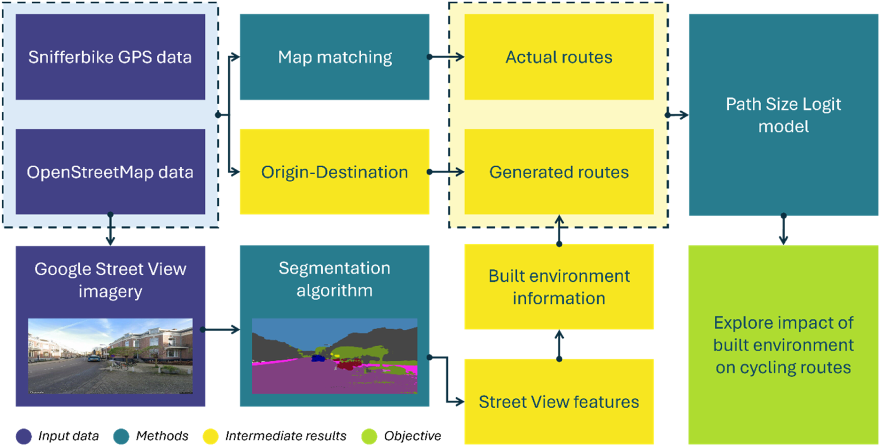
Data
Study area and Snifferbike data
Utrecht, Netherlands, as shown in Figure 2, is renowned for its exceptional cycling infrastructure, making it one of the most bike-friendly cities in the world. This study area occupies an area of 99.32 km2 with roughly Cycling network of the study area.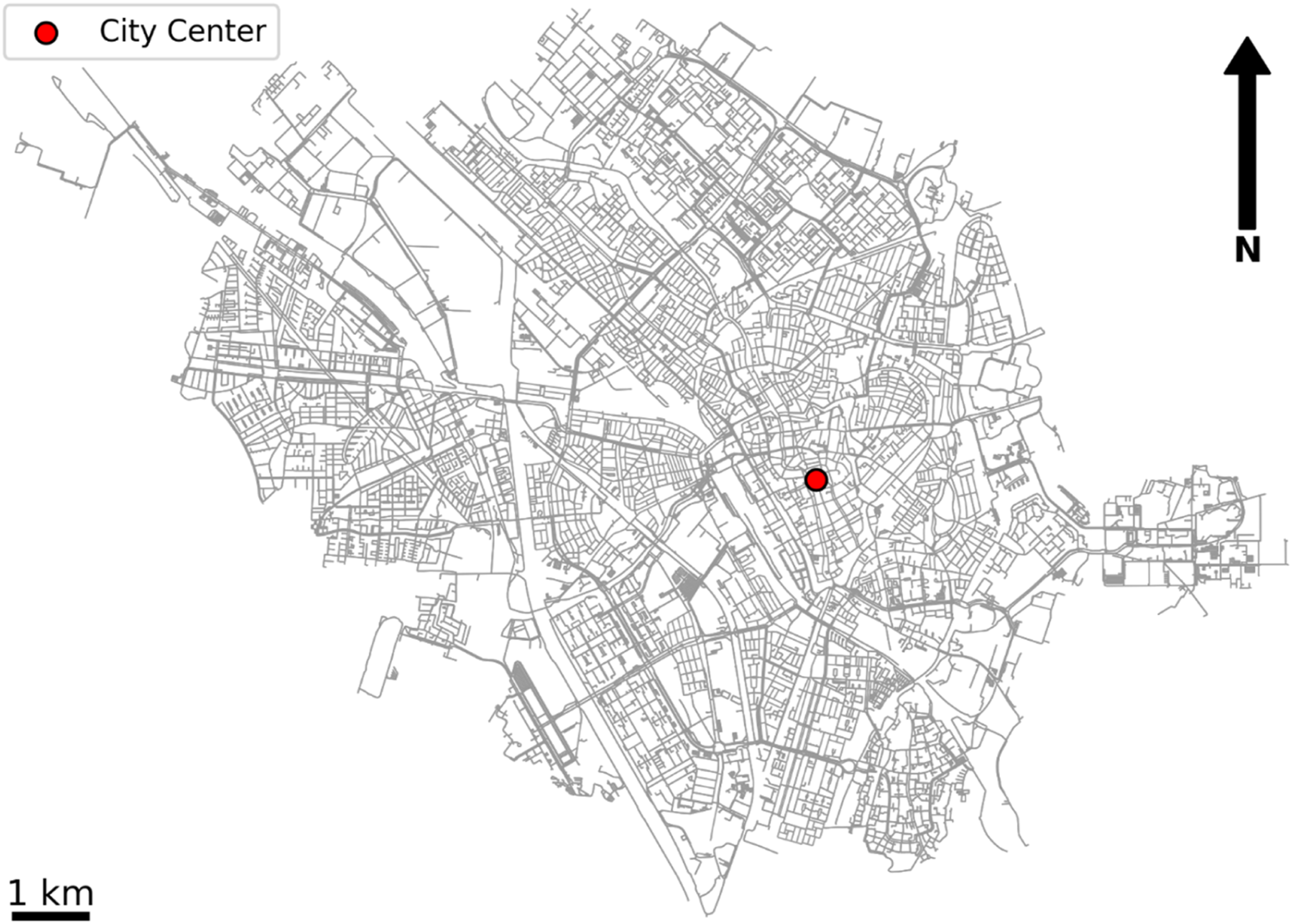
In this study, data from the Stifferbike system 3 is used to explore the impact of street-level built environments on cyclists’ route choices. The data contains 10,349 trips between June 2019 and April 2021, with GPS location collected every 10 sec. Each trip provides timestamps and GPS traces. Due to the error of GPS information, cyclist trajectories usually need to be map-matched to existing road networks. The map-matching algorithm developed by Yang and Gidófalvi (2018) is applied to convert cyclists’ trajectories into polyline trip routes.
Built environment information
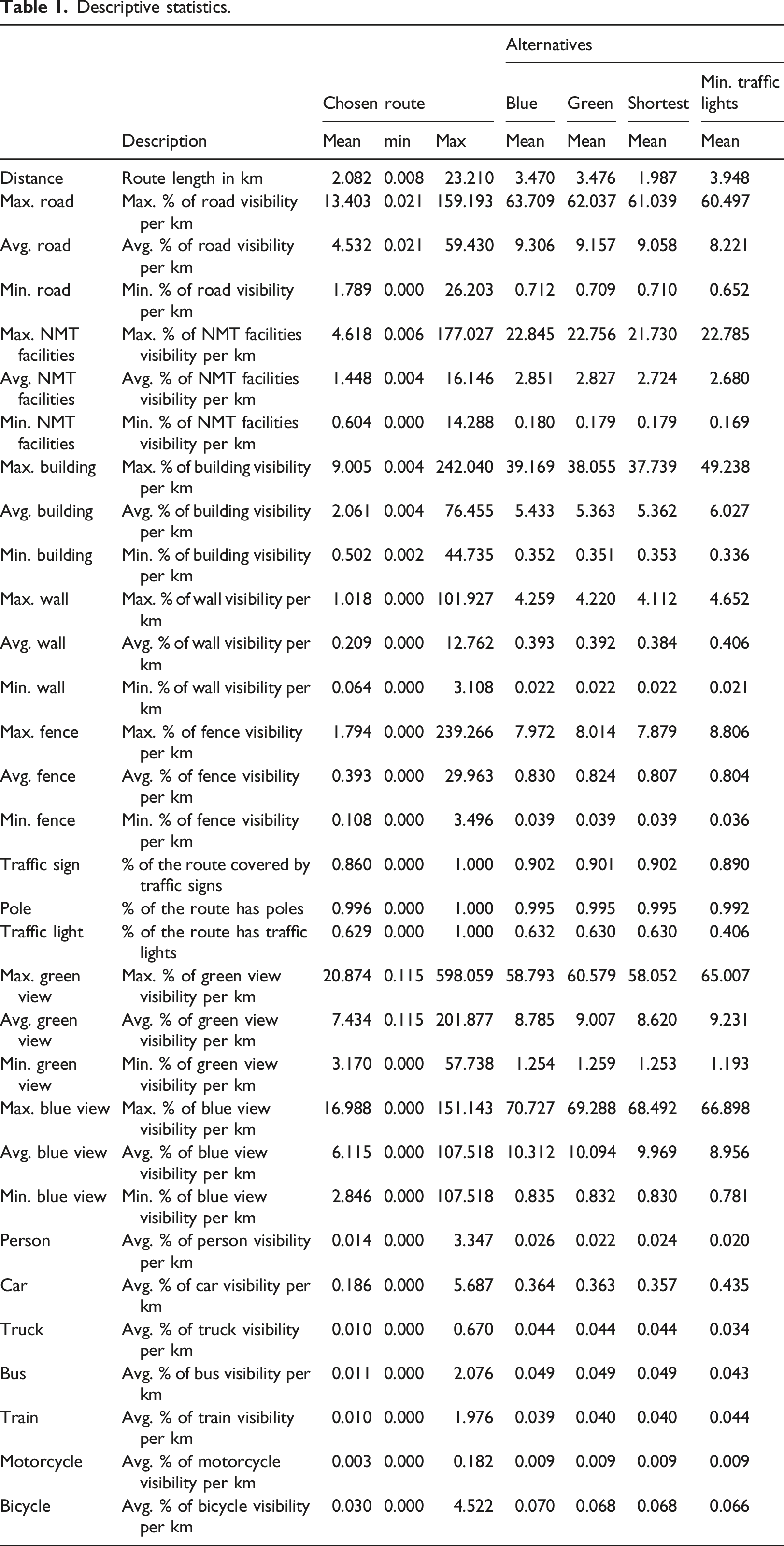
Descriptive statistics.
Methodology
Choice set generation
The cyclist route choice set is generated with the labeled route method proposed by Ben-Akiva et al. (1984). The method has been widely applied in cyclist route choice studies (Broach et al., 2010; Khatri et al., 2016). Four alternative routes were generated alongside one selected route. Using the labeled route method, Dijkstra’s algorithm was employed to identify alternative paths between the origin and destination, optimizing specific built environment attributes (Dijkstra, 1959). Apart from the shortest path, alternative routes were determined based on route-level attributes such as green view, blue view, and minimal traffic lights. These routes were integrated into the street networks of the study area to obtain attributes along each route.
Path size logit
The path size logit (PSL) model is an extension of the traditional multinomial logit model used in transportation and route choice analysis (Ben-Akiva and Bierlaire, 1999). It addresses the issue of overlapping routes by incorporating a path size factor into the utility function, which adjusts the probability of selecting a route based on its uniqueness compared to other alternatives. In transportation networks, many routes share common segments, leading to correlation among alternatives. This violates the Independence of Irrelevant Alternatives (IIA) property of the standard logit model. The PSL model corrects this by introducing a path size adjustment term. The path size factor (
The utility of route k is modified to include the logarithm of the path size factor:
The probability of choosing route k from the choice set C is expressed as follows: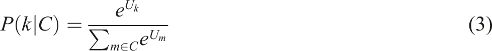
Including the path size factor ensures that routes with significant overlap receive lower adjusted utilities, reducing the likelihood of selecting similar alternatives. This makes the model more realistic and better reflects observed route choice behavior in networks with overlapping paths.
Results
Route choice preference
Model results (n = 29,762).
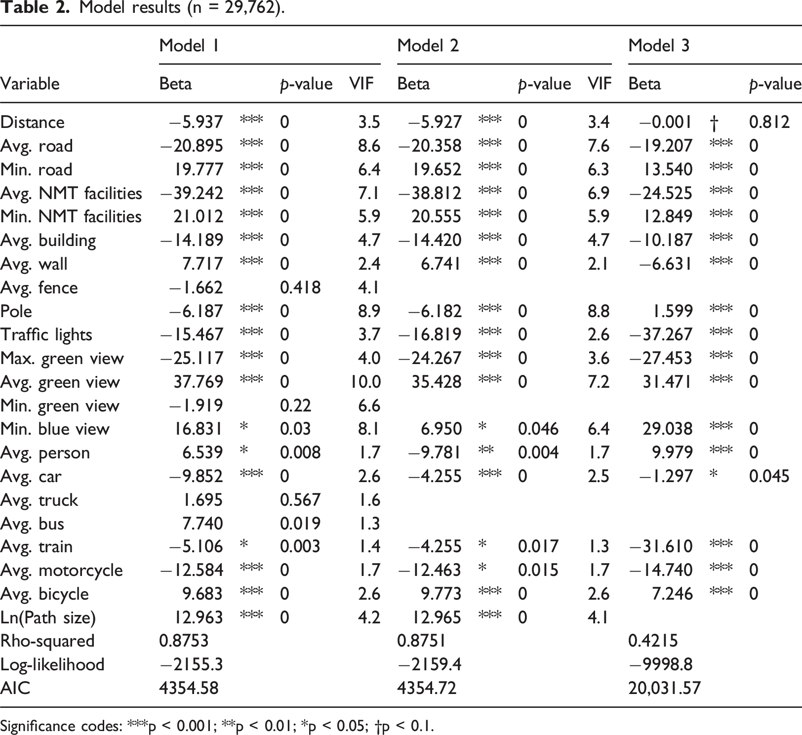
Significance codes: ***p < 0.001; **p < 0.01; *p < 0.05; †p < 0.1.
The results from Table 2 reveal several important insights into the impact of the built environment on cyclists’ route preferences. Both Model 1 and Model 2, demonstrate strong fits to the data with similar Rho-squared values of 0.8753 and 0.8751. Model 2 offers an improved approach by excluding insignificant variables, which do not strongly impact route choice in this dataset. Model 2 shows a slightly lower AIC value by removing insignificant variables. This simplification improves model interpretability and fit while maintaining robustness.
Several variables significantly influence cyclists’ route choices. Notably, the distance negatively impacts route utility which indicates the cyclists’ preference for shorter routes. Similarly, routes with wider roads will be less likely to be selected due to their association with less cycling-friendly environments. However, the positive effect of the minimum observed road indicates that cyclists will prefer the route to have a certain width of the road. This may be because the certain lane width of the road facility shared by cyclists and vehicles makes cyclists feel safer. At the same time, the result shows that the wider the NMT facilities the less likely cyclists will select the route. The reason behind that can be the wider the NMT facilities the more pedestrians are going to use the facility which may lead to the inconvenience or illegal of cycling on it. Meanwhile, cyclists would prefer to have NMT facilities throughout their cycling routes. Cyclists are less likely to select the routes that go through the residence area because of the significant negative impacts of the average building index throughout the route. However, the route with a higher wall index is preferred by cyclists which is possible because the wall separates the NMT facilities from the motorways. Another reason is that diverse facades would increase the cyclist’s preference for the route (Ramirez Juarez et al., 2023). The average green view index is positively associated with route preference, highlighting the preference for consistent greenery along routes. This finding is consistent with existing work (Ramirez Juarez et al., 2023). Interestingly, the higher maximum green view index has a negative influence, suggesting that cyclists would prefer routes with more evenly distributed greenery. Additionally, higher densities of visible people (average person) and bicycles (average bicycle) increase route attractiveness, possibly reflecting social and safety considerations. In contrast, the presence of higher densities of cars, trains, and motorcycles negatively impact route preferences, indicating a desire to avoid noisy and motorized environments. The result is consistent with the works conducted by Lu et al. (2018) and Sener et al. (2009). The minimum blue view index, representing the visibility of blue elements such as the sky or water, also positively influences route choice, underscoring the importance of scenic features. This is also consistent with the work of Ramirez Juarez et al. (2023) which pointed out that cyclists wish to avoid the routes with tall buildings. The results indicate that cyclists chose the routes with lower traffic light coverage. The result is consistent with the work conducted by Krenn et al. (2014) and Menghini et al.(2010).
We estimated an additional model (Model 3) with the same specification as Model 2, except for the omission of the path size correction. This adjustment was made to assess the impact of the path size correction on model goodness-of-fit and the coefficient values, along with their equivalent cycling distance effects (discussed further in the next subsection). The results indicate a significant decrease in rho-squared, from 0.8751 to 0.4219. While most coefficient estimates retain the same signs, their values change significantly. These findings highlight that failing to account for overlap between alternatives can substantially distort attribute effects, resulting in biased and inaccurate estimates that compromise the reliability of policy analysis.
Operationalizing coefficients as willingness-to-cycle measures
Using coefficient ratios to present a marginal rate of substitution between variables has been applied to measure the willingness-to-pay and willingness-to-walk (Basu and Sevtsuk, 2022; Olszewski and Wibowo, 2005). By capturing the tradeoffs between two variables, such coefficient ratios serve as valuable tools for policy-making. In this study, we use route distance as the reference variable, allowing the effects of built environment factors to be expressed in terms of “willingness-to-cycle.” For example, 
Interpretation of route choice model coefficients as “willingness-to-cycle.”
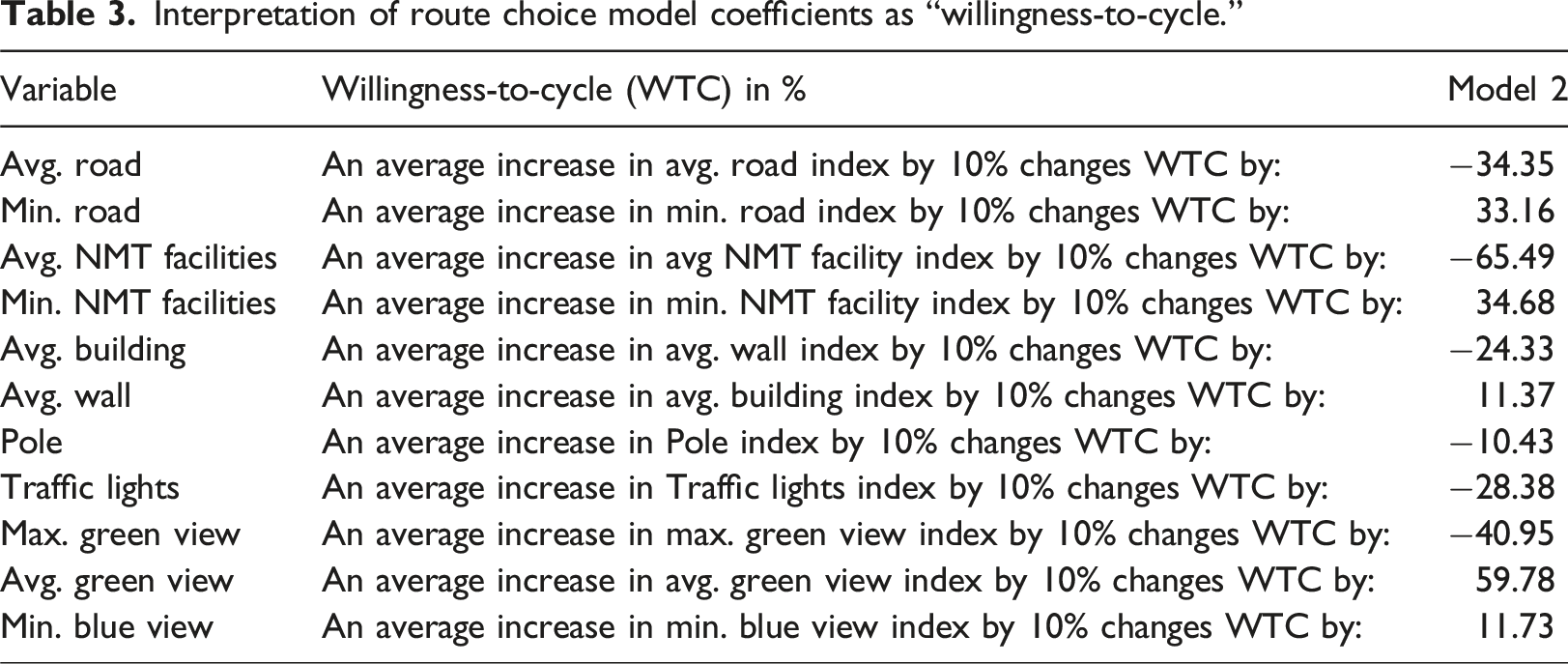
Figure 3 illustrates the willingness-to-cycle to various urban amenities. In this study, we classified these amenities into three categories: Educational facilities (e.g., schools, kindergartens, and childcare centers), Healthcare facilities (e.g., dentists, clinics, pharmacies, and hospitals), and Social facilities (e.g., libraries, art centers, and social centers). Figure 3 shows that the area near the facilities has better built environment that make cyclists feel less perceived distance which lead to a higher willingness-to-cycle. These examples point out the importance for urban planners to understand how the built environment at the street level influences the perceived distance of routes, and potentially the actual geographic boundaries of facility catchment areas that people are willing to cycle to. We anticipate that these insights will be valuable for other accessibility analyses focused on cyclists, such as identifying transit or food deserts or developing a transport poverty index for neighborhoods. Willingness-to-cycle to different Points of Interest.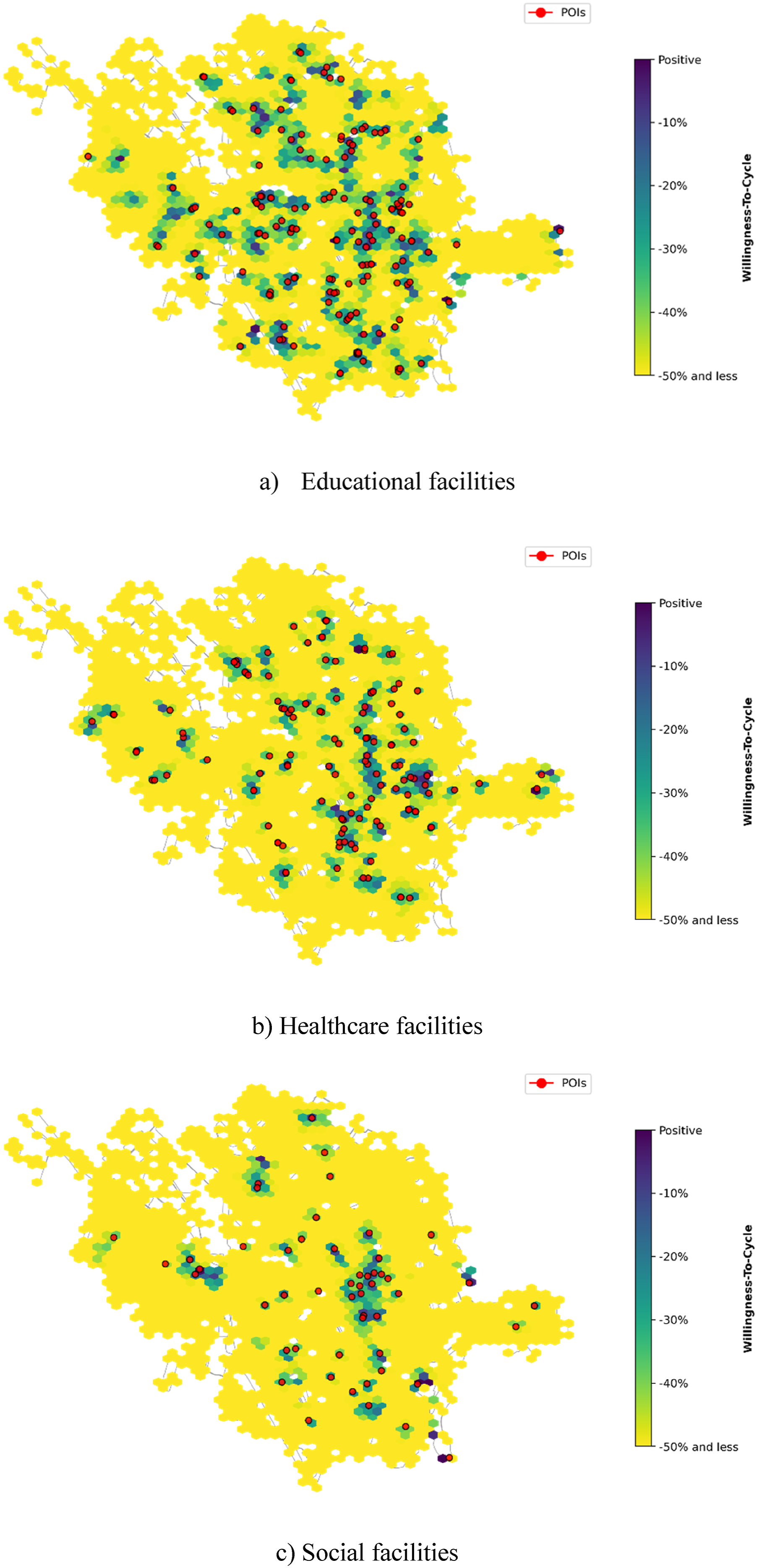
Conclusion
In this study, a comprehensive analysis of cyclists’ route choices by integrating GPS data and street view images is conducted to understand the impact of the street-level built environment on cycling route choice behavior. Our findings confirm that multiple factors shape route choices, including road visibility, non-motorized transport (NMT) facilities, greenery, and other built environment characteristics. Consistent with previous research, our results highlight that cyclists prefer routes with proper NMT infrastructure, reduced vehicular presence, and enhanced environmental aesthetics, such as greenery and blue views. Interestingly, while the presence of green and blue spaces positively influences route selection, an uneven distribution of such elements can negatively impact cycling preferences. Since roads with minimal traffic lights enhance travel continuity, the presence of traffic lights decreases the preference of cyclists. Our analysis further emphasizes that cyclists prioritize routes that balance travel efficiency and comfort. Shorter distances remain a primary determinant of route choice, yet factors such as greenery, blue views, and the presence of urban design elements significantly contribute to a positive cycling experience.
From a policy perspective, our findings provide deep insights into cyclable city concept for urban planners and transportation officials. Investing in dedicated cycling infrastructure, particularly in areas with high vehicular traffic, can significantly enhance route attractiveness. Additionally, incorporating green and blue spaces into urban cycling networks can further encourage cycling by improving the overall user experience. However, attention must be given to the equitable distribution of such elements to ensure consistent exposure throughout a route.
Despite its contributions, this study has several limitations. While the study successfully extracted and quantified several built environment features, other potentially influential factors, such as noise levels, air quality, and social perceptions of safety, were not considered. Second, Utrecht is highly favorable to cyclists, which may not be able to represent the route choice behavior in other cities. More cities will be included in the future work in order to identify the similarities and differences. Third, more advanced method, such as adaptive path size logit (Duncan et al., 2020) and machine learning (Magnana et al., 2022; Marra and Corman, 2025), could be applied to better explain the data. Finally, route choices may vary under different weather and road conditions, as well as across age groups, are not considered in this study. Future research could expand on these aspects to provide a more comprehensive understanding of route choice determinants.
Footnotes
Funding
The authors disclosed receipt of the following financial support for the research, authorship, and/or publication of this article: This work was partially supported by the Direktoratet for høyere utdanning og kompetanse (HK-dir) (UTF-2020/10115) and GRC pilot: Big data technology-enabled sustainable and social just cities (No. 352058).
Declaration of conflicting interests
The authors declared no potential conflicts of interest with respect to the research, authorship, and/or publication of this article.
Data Availability Statement
Data sharing not applicable to this article as no datasets were generated or analyzed during the current study.