
Abstract
Urban renewal in high-density cities presents a complex challenge when it comes to balancing social-environmental performance and economic benefits; improvements to the built environment and social wellbeing may be associated with substantial costs and economic loss, and particularly so where land resources are scarce and highly valued. The interplay that takes place between sustainable targets tends to be very complicated. This study proposes a decision-making support framework that can quantify the synergies and trade-offs between economic, environmental, and social targets pertaining to land use change and public open space (OS) provision in urban renewal processes. The proposed decision-making support framework operates at both neighbourhood and building levels, and is comprised of three analytical components: a redevelopment trend analysis module, a three-dimensional land use simulation module, and a sustainable performance evaluation module. One high-density and ageing district in Hong Kong, Yau Mong district, was selected as the case study area for this work. Six planning scenarios were built which reflect various priorities and principles including economic benefits, environmental benefits, the equal distribution of OS provision and enhancing the quality of OS. The findings suggest that there is a trade-off relationship between economic-environmental targets, a synergic relationship between social-environmental targets, and a mediational relationship between economic-social targets. Planning strategies such as rezoning, land use reconfigurations, plot ratio adjustment and the transfer of development rights could be triangulated as strategic approaches by which to maximising the synergies and achieve better sustainability. The study not only contributes to theory by introducing a prototype of a comprehensive decision-making framework to evaluate sustainability performance, but also provides important insights into reconciling the divergent sustainable targets inherent in urban renewal.
Introduction
Synergies are gained when achievements pertaining to one goal contribute to progress in other goals, whereas trade-offs occur when progress achieved towards one goal has detrimental effects on other goals (Breuer et al., 2019). When it comes to the economic, social, and environmental targets of sustainable urban development, the interplay between synergies and trade-offs is intricate. Balancing these economic-social-environmental performances presents significant challenges, especially in complex urban renewal process. The enhancement of one indicator sometimes may come at the expense of others whilst the diverse needs of different stakeholders cannot always be equally satisfied (Ferretti and Grosso, 2019; Zheng et al., 2017a). It is therefore essential, in order to support urban renewal decision-making, to analyse the synergy and trade-off relationships that exist among the targets and quantify the impacts of the human–environment processes on overall sustainability.
Existing decision support tools for urban renewal primarily exist within two-dimensional (2D) space and are focused on land use suitability analysis, environmental impact assessment, infrastructure capacity analysis, and sustainability assessment (Wang et al., 2015; Zheng et al., 2017b). Three-dimensional (3D) modelling that accounts for building height and density and through so doing better represent the sustainable performances of different land use schemes in renewal cases remain limited. Decision-making for urban renewal tends to occur at neighbourhood and project levels. Existent studies have typically focused on either the neighbourhood level (Dogan et al., 2020; Zheng et al., 2017b) or the project level (Manganelli et al., 2020; Xu et al., 2019). Furthermore, existing decision support systems tend to concentrate on one or several specific objectives, with insufficient consideration given to the synergies and trade-offs that exist between interrelated sustainable targets. Therefore, a decision-making support tool for long-term planning that compares different sustainable objectives and examines their synergies and trade-off relationships would significantly contribute to literature.
In high-density and ageing urban areas such as Hong Kong, buildings deteriorate rapidly, outpacing redevelopment capacity (Ho et al., 2012; Urban Renewal Authority, 2022). Although the compact urban form, characterised by high-density urban settlement, increased accessibility and mixed land use offers some benefits, it also associated with negative impacts. For example, the extremely dense development in areas such as Kowloon greatly limits land availability for green spaces, and leads to notably low greenery performance scores (Lai et al., 2018). The lack of quality open space in old districts along with a substantial elderly population hinders the opportunities for residents to engage in outdoor activities (Sun et al., 2020; Yung et al., 2016). It follows, all else being equal, that improving building conditions, the built environment, and social wellbeing is essential for urban renewal in high-density and ageing districts.
Against this backdrop, this study proposes a decision-making support framework that builds upon a 3D land use model operating at both building and neighbourhood levels to simulate the trade-offs among economic, social, and environmental performances of different urban renewal scenarios within Hong Kong. The framework comprises three main modules: (1) a redevelopment trend analysis module, (2) a 3D land use simulation module, and (3) a sustainable performance evaluation module. By building scenarios focused on public open space (OS), critical elements related to social welfare, living environment, and urban land use, the relationships between OS distribution, urban density and sustainable performances are illustrated. Scenario comparison reveals the synergistic and trade-off relationships that exist between multiple renewal targets, and through so doing supports sustainable decision-making. Finally, the paper proposes renewal strategies for Hong Kong’s old urban districts.
Literature review
Synergies and trade-offs between sustainable targets in urban development
Although sustainable goals and targets, such as the Sustainable Development Goals (SDGs) adopted by the United Nations (UN), were initially recognised as being interlinked and integrated, difficulties arose during the implementation process. For example, while SDG 3 (Good health and wellbeing) aligns positively with SDG 1 (No poverty), SDG 6 (Clean water and sanitation), and SDG 10 (Reduced inequalities), it presents negative associations with SDG 12 (Responsible consumption and production) and SDG 15 (Life on land) (Pradhan et al., 2017). Trade-offs between economic and environmental targets were often observed in urban development. This was in part because rapid urbanisation altered landscape patterns and caused a decline in ecosystem service (Wu et al., 2022). However, this trade-off relationship may also transition to an economy–environment synergistic relationship as the level of economic development advances. For example, a U-shaped curve relationship between urbanisation and ecosystem service value was identified in eastern China (Luo et al., 2022), suggesting that the relationships which exist and develop between sustainable targets may shift as conditions change.
Challenges pertaining to recognising the intricate relationships which exist among and between sustainable goals were caused by the lack of a definitive framework to address synergies and trade-offs, along with limited understanding of how diverse sustainable goals interact (Nilsson et al., 2018; Renaud et al., 2022). While professional scenario design with quantitative evaluation can facilitate the selection of better plans (Adams et al., 2016), a deeper understanding of the interactions that occur between economic, environmental, and social targets remains essential if trade-offs are to be minimised, synergies maximised.
Evaluation criteria for sustainable urban renewal
Urban sustainability is generally delineated by three dimensions: economic, social, and environmental. In certain discourses, a fourth dimension, governance, is also integrated. Indicators used in various international case studies offer valuable insights for evaluating sustainable urban renewal. Given the diverse conditions that exist across cities/contexts both nationally and globally, it is challenging to establish a one-size-fits-all evaluation system, and nor can a single case encompass all factors without considering specific localised characteristics. Specified factors are selected or designated based on the objectives of different renewal projects. Figure S1 summarises the key indicators that have been widely used in various existent studies.
Previous research predominantly employed a comprehensive multicriteria evaluation framework to assess sustainability performances and sought to optimise aspects of sustainable development. However, the practice revealed the existence of conflicts between individual sustainability targets (Hassan and Lee, 2015; Wang et al., 2020), thereby posing challenge in pinpointing optimised solutions. This study aims to address this deficiency by focussing on evaluating the synergies and trade-offs that exist between sustainability targets. Unlike previous studies that have attempted to present an optimised resolution (often impractical), the focus here is two-fold: unravelling the relationships that exist between different targets and proposing pragmatic strategies.
Planning support systems for urban renewal
Planning Support Systems (PSSs) aid in addressing complex planning issues through land development assessments, urban sustainability assessment, and facilitating data-driven stakeholder interactions for smart governance (Chrysochoou et al., 2012; Pan et al., 2022a; Vasilevska et al., 2022). Two strands of planning supporting approaches have been widely implemented: participatory approaches for spatial negotiations to support collaborative decision-making and instrumental approaches which provide scientific analysis (Table S1). Participatory approaches integrate diverse stakeholder concerns through environmental, socioeconomic, and biophysical performance assessments, and can improve inclusiveness and contextualisation within planning decision-making (Omidipoor et al., 2019; Pan et al., 2022b).
Instrumental approaches address the complexity and uncertainty of urban renewal through quantitative analysis, assessing potential planning strategies and their variated impacts. For example, environmental indices and land use suitability assessment have been applied to support fund allocation and site selection for redevelopment (Chrysochoou et al., 2012; Wang et al., 2015). Scenarios comparing different social amenity distributions were evaluated based on local household walking distances (Beames et al., 2018), visibility and accessibility of amenities (Natapov et al., 2023). GIS-based mapping and multicriteria evaluations have also been used to explore how various urban transformation modes quantitatively affect neighbourhood-level green space (Vasilevska et al., 2022) and national-level ecosystem services (Pilogallo and Scorza, 2022). These designated instruments provide insights into land suitability, environmental performance, and the different impacts and benefits of urban renewal. However, existing PPSs mostly focus on one or several specific objectives; there has been limited investigation of the synergies and trade-offs that exist between sustainable goals.
Decision-making framework
There are three main modules in the decision-making framework: a redevelopment trend analysis module, a 3D land use simulation module, and a sustainable performance evaluation module (see Figure 1). Specifically, the redevelopment trend analysis module maps the probability of different land uses and building redevelopment in the future. By integrating the results from redevelopment trend analysis with the predicted capacity for redevelopment, various redevelopment scenarios are established in the 3D land use planning simulation module. Under these scenarios, the economic, environmental, and social performances of different redevelopment proposals can be evaluated to identify the synergies and trade-offs in achieving sustainable targets. Urban Renewal decision-making framework with 3D land use simulation.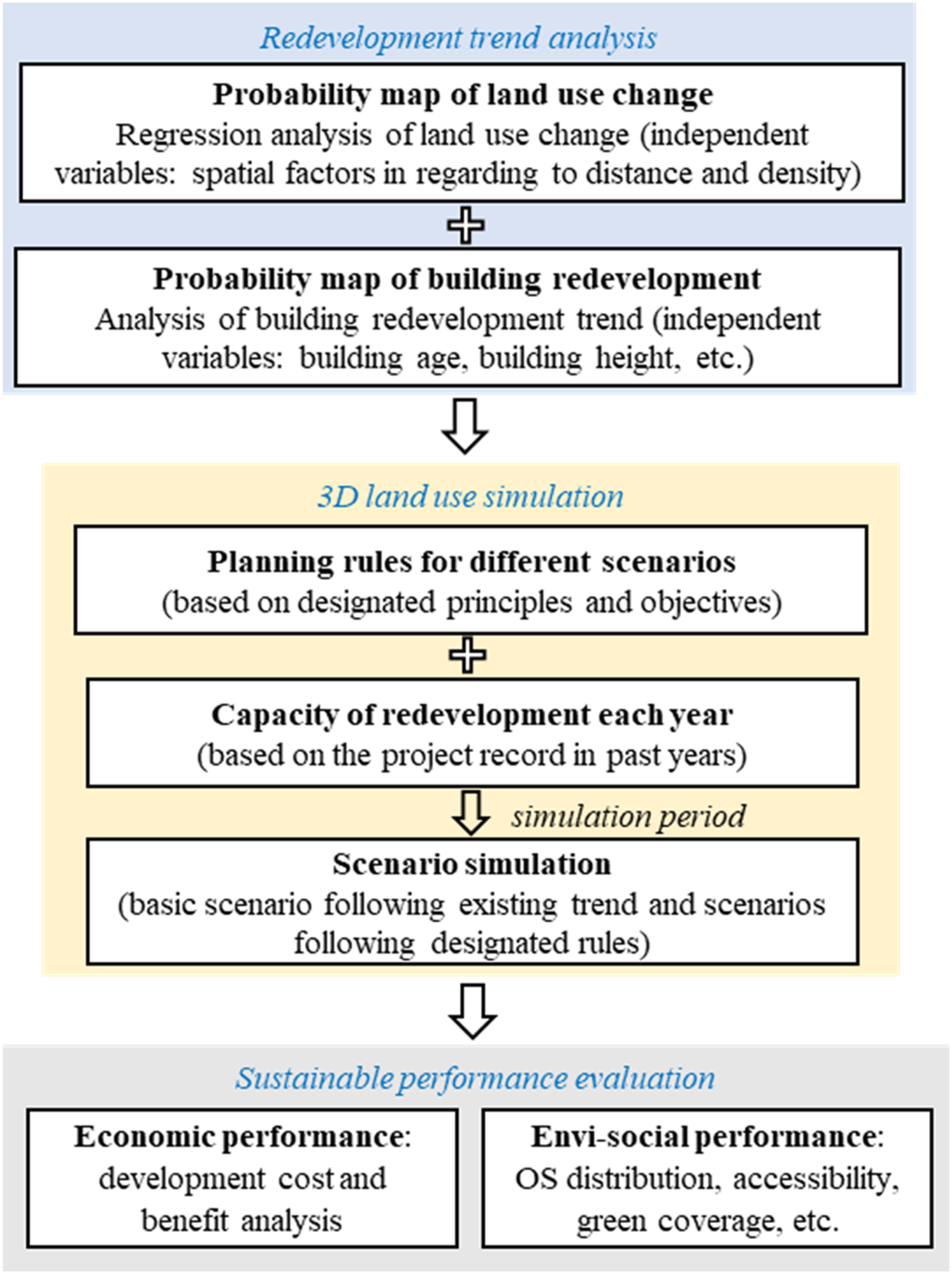
The redevelopment trend analysis module
To determine the suitability of different land uses, a logistic regression analysis is applied. The dependent variables are binary (0 or 1) and represent the presence or absence of different land use types such as commercial, residential, and green space. These land uses can be adapted to reflect specific contexts. The independent variables comprise spatial driving factors and include accessibility to, and density, of different facilities. Similarly, the independent variables are determined based on contextual factors. The regression analysis employed can facilitate identification of the correlations that exist between the independent variables and the dependent variables. The outcomes of the same can inform the land use suitability of different land parcels. This, in turn, can become an important input for measuring both the probability of land use change and identifying priorities of redevelopment.
Predicting land use changes requires an understanding of the sequence of building demolitions, as land repurposing is contingent upon demolition. The choice of indicators to determine redevelopment priorities for different land parcels varies across contexts. Alongside the contextual indicators, a building-level probability map of redevelopment can be developed to inform simulation.
Three-dimensional land use simulation module
This module uses the probability maps of land use change and building redevelopment to sequence the demolition and redevelopment of buildings. In the simulation, buildings are demolished by rank, and the vacated sites are redeveloped one by one under a designated plot ratio until the targeted area of redeveloped gross floor area (GFA) is achieved. Within the model, consideration is given to budget and executive capability restrictions based on past experiences. Various redevelopment scenarios can be designed to explore different outcomes based on how the vacated sites could be utilised using the guiding principles of development and intended land uses. These scenarios could be further tailored to reflect local contextual factors, and thereby enable simulations to provide relevant insights for different urban settings.
Sustainable performance evaluation module
This module focuses on evaluating the sustainable performance of different redevelopment scenarios generated by the 3D land use simulation module. By focussing on the key agents (e.g. government, developer and residents) in the process, economic costs and benefits are measured throughout the entire renewal process: land acquisition, land sale, construction, and house sale. The contextual factors can be tailored to decide the calculation method of economic costs and benefits. In terms of environmental and social performance, different indicators relating to social and environmental sustainability are used in order to evaluate different scenarios and identify the synergies and trade-offs that exist with regard to achieving sustainable goals. The selection of indicators needs to be carefully conducted to reflect the unique attributes of each case.
Case study
The Yau Ma Tei and Mong Kok (Yau Mong) districts in Kowloon, Hong Kong are densely built and populated, with a total population of 213,000 in 2017 within an area of 2.12 km2, resulting an average population density of 100,472 people per km2 living within around 3300 buildings (Urban Renewal Authority, 2022). Given these challenges, Yau Mong was selected as the case study area (Figure 2). The location of the study area in Kowloon, Hong Kong. (a) The location of Kowloon district in Hong Kong (b) The location of the study area in Kowloon.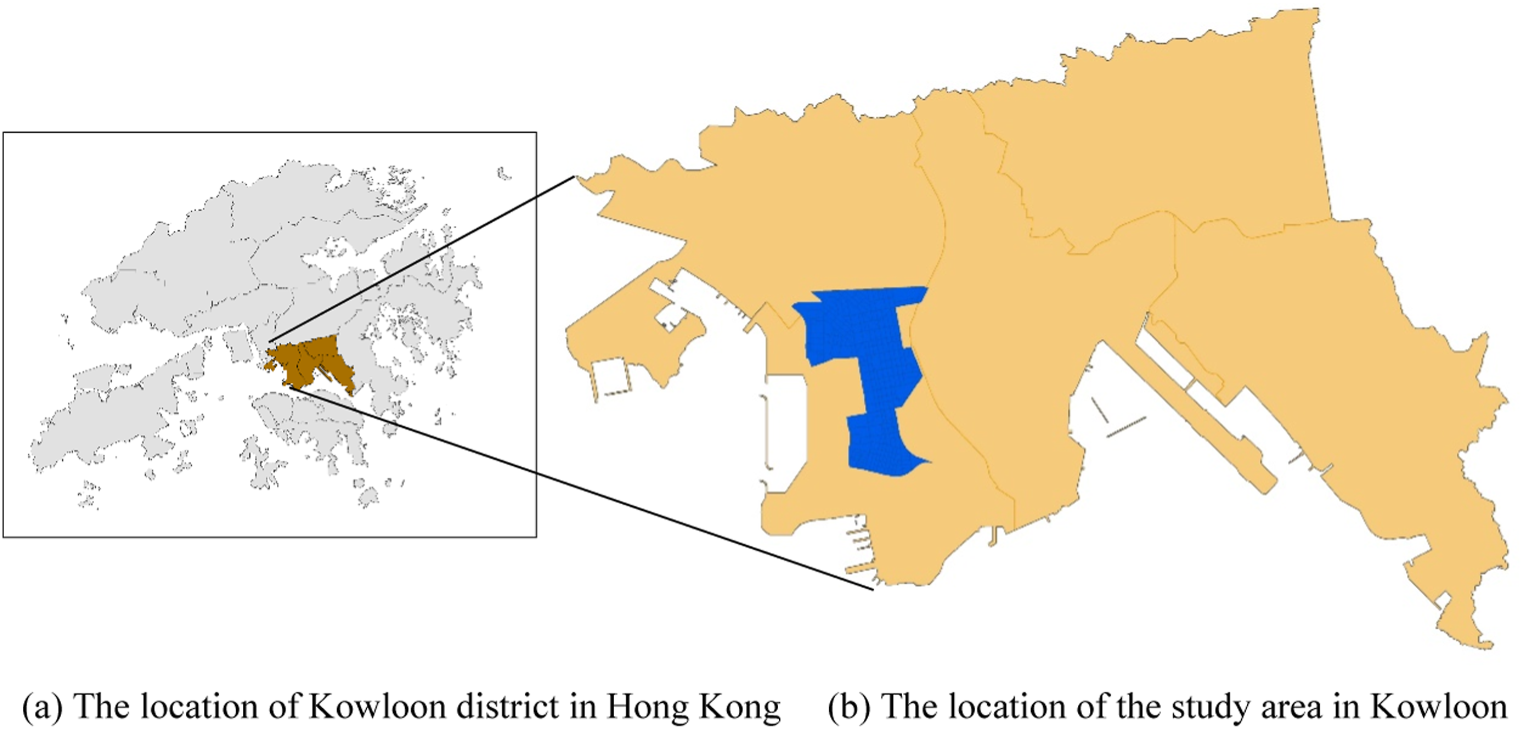
The area is experiencing ageing population and building condition. Approximately 65% of buildings are more than 50 years old (Figure 3). The total area of OS within the case study is, after adjustments using Google Map, 14.7 ha. Most of these spaces are very small rest gardens and sitting-out areas. The average OS area per capita, calculated by ArcGIS, is 0.7 m2/capita. According to ‘Hong Kong Planning Standards and Guidelines’, the standard minimum OS provision is 2 m2/capita. The shortfall in the overall supply of OS is a significant issue that needs to be addressed within the case study area. Building features of the case area of Yau Mong, Hong Kong. Note: The information of building age is derived from B1000 digital map dataset from Lands Department as well as the Web site of Centanet Property https://hk.centanet.com/info/index. The area of the study case is 2.12 km2. Scale is continuous and changing across a 3D view, as buildings that are far away are at a different scale than buildings that are closer.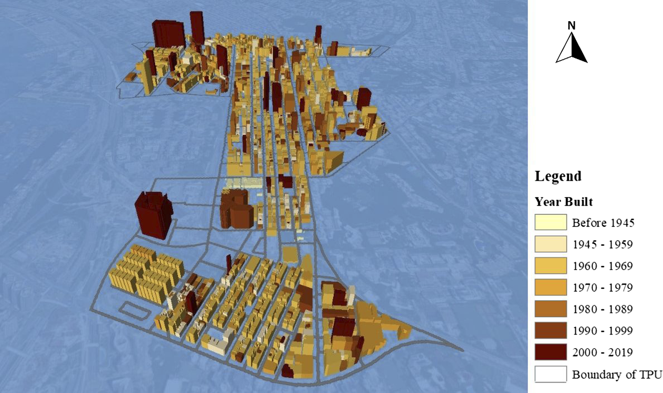
In this study, the three modules of the decision-making framework were established using ArcGIS and Netlogo. Input data regarding land use and building attributes were processed in ArcGIS, while urban renewal scenarios which assumed various future demands and planning principles were designed using NetLogo.
Analysis of trends and scenario simulations
The redevelopment trend analysis module used residential, commercial, government, institutional and community (GIC) land, and OS as the dependent variables, which were represented in 10 m × 10 m cells of raster maps. Independent variables included distances to the nearest railway stations, bus stations, minibus stations, main roads, facilities, and the density of Points of Interest (POI) such as shops and accommodation (see Table S2). Land use data was obtained from the Lands Department whilst POI data was collected from Gaode map. Logistic regression analysis was conducted for each land use type to calculate the probability for all cells.
By analysing historical redevelopment projects in the study area and referring to existing studies, it was found that building age and building height are two indicators that are strongly associated with the probability of redevelopment (Lai et al., 2021; Zheng et al., 2017b). Older buildings are generally in poorer condition and need demolishing, while buildings with lower heights present easier opportunities, by redeveloping them into taller buildings, for economic profit. Given this, buildings were ranked first by their age, and then by their height if were of the same age. The higher the rank, the higher the priority given to the building for demolition and redevelopment. Data regarding years of construction was collected from the Rating and Valuation Department of Hong Kong and Centanet Property. 1 Around 65% of buildings were over 50 years old. The data pertaining to building height referred to ‘Roof Levels’ and was sourced from the digital map of ‘Building’ in the B1000 dataset derived from the Lands Department.
In this case study, improving greening configurations and OS are considered key criteria for sustainable development (Chen et al., 2023). Among all types of land use changes, increase of OS was evaluated as the best way to synergise the economic, environmental, and social targets (Chan et al., 2016). Six scenarios were proposed to consider open space configuration in the redevelopment process. Figure S2 presents a flow chart of simulating the urban renewal process of a specified Scenario (x). Details of each scenario are as follows.
Scenario (a): Baseline Redevelopment. Redevelopment occurs under designated plot ratio without changes in land use, and therefore follows existing trends of economic development.
Scenario (b): Suitable Redevelopment. The land use is changed based on the evaluated suitability of the building site. If the site is more suitable for OS, it is designated as such; otherwise, it is redeveloped for either residential or commercial use depending on which is deemed more suitable.
Scenario (c): Equal distribution of OS. This scenario represents altering land use according to the OS area per capita within each TPU. Specifically, if a TPU exhibits a relatively low OS area per capita, the land use is changed to OS. Conversely, if the OS area per capita is higher, the land use is redeveloped to either residential or commercial use depending upon which is assessed to be more suitable.
Scenario (d): OS provision and Transferring Development Rights (TDR). Based on land suitability, if the land use is changed to OS, the GFA to be demolished is calculated and this GFA is transferred to the next building to be redeveloped, either for residential or commercial use.
Scenario (e): OS provision and area expansion. Change the land use to OS, if it is in a targeted TPU area and located close to existing OSs (within 100 m).
Scenario (f): OS provision and road merging. Change the land use of selected road land to OS within targeted TPUs that are characterised by high population density and relatively low traffic flows.
The renewal simulation target was based on Kowloon’s historical acquisition records:around 10,000 m2 GFA per year. The plot ratios of redeveloped buildings were set at 8 (low) and 10 (high) for residential buildings, and 15 for commercial buildings according to the highest standard stipulated in the ordinance ‘Cap123F’.
Measurement of sustainable performance
Demand for redevelopment originates from the residents within a (given) community. Urban Renewal Authority acts as a catalyst for redevelopment, while private sectors (e.g. developers) push forward the implementation of projects. There are various key agents such as developers, property owners, contractors and house buyers. A systematic dynamic diagram of capital flow for the case study is shown in Figure S3. The variables and formulas for calculation are explained in Table S3.
Under current land use configuration, the area of OS is about 13.0 ha, and constitutes approximately 6.0% of the study area, while the remaining area is utilised for built-up uses such as residential, commercial, roads, and GIC. The OS is primarily covered by greenery, and this significantly contributes to the ambiance of the dense urban core. Due to the low percentage of land allocated to OS, ‘the area of OS’ was chosen as a critical indicator to evaluate the environmental performance of the district. The potential to expand existing OS depends upon the redevelopment feasibility of adjacent plots and their land use suitability. If new OS is provided on an adjacent plot after a building is demolished, it will merge with existing OSs as expanded OS.
To gain a more nuanced analysis of area lower OS percentages and poorer environmental performance, smaller units known Tertiary Planning Units (TPUs) were utilised. TPUs with an OS percentage lower than 6.0% were identified as ‘targeted TPUs’, as this indicated that there was a higher demand for them to be improved. ‘The area of OS in targeted TPUs’ was selected as an indicator to assess the environmental performance.
Accessibility to public OS and the equitable distribution of public OS are two critical aspects when it comes to assessing residents’ wellbeing. Accessibility was measured by the average distance to OS within the study area. Instead of using the absolute value of “OS area per capita” which highly overlaps with the environmental indicator of “the area of OS”, social evaluation places a greater emphasis on the equal distribution of public OS. To this end, the indicator ‘inequality ratio of OS sharing’ was introduced and is defined as the relative ratio of OS sharing per capita in the targeted TPUs to the OS sharing per capita in the overall study area.
Model validation
To validate the proposed decision-making framework, a focus group meeting was held with URA staff, including two Directors, one General Manager and seven public officials. During the meeting, the research team presented the modelling process and the simulation results. The participants assessed the effectiveness of the framework and offered feedback on practical issues related to property rights as well as residents’ willingness to engage in the renewal process. These inputs all contributed to refining the model.
Case study results
Logistic regression and land use suitability
Based on existing land use data, statistical analysis was conducted to examine and quantify the relationships that existed between land use locations and a set of explanatory factors. The results, as shown in Table S3, display coefficients from the regression analysis; supporting the formulation of land suitability maps for Residential, Commercial, GIC, and Open Space uses. The goodness of fit for the regression models ranged from approximately 0.7 to 0.9.
For example, at the district level for Open Space, the accuracy of the logistic regression classifier on the test set was satisfactory at a 0.91 level. The Confusion Matrix describes the performance of a classification model.
The formula for logistic regression is
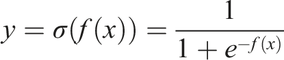
y represents the cell value of land suitability for OS; β0 is the intersect of f(x); βi is the coefficients of variables listed in Table S2; xi is the cell value of the independent variable i; and f(x) is calculated as follows.

Simulation results and multi-criteria evaluation
Figure 4 illustrates the land use patterns of the six scenarios. Table 1 shows the results of the scenarios’ performances in terms of economic, social, and environmental dimensions. Scenarios were ranked based on the values of the assessment indicators. Simulation results of land use patterns under different scenarios. Note: The red lines outline existing buildings. The coloured plots illustrate existing OS (blue plot), redeveloped buildings (black plots), and increased OS (yellow plot) after urban renewal. Scenario (a)-Baseline redevelopment. Scenario (b)-OS provision. Scenario (c)-Equal distribution. Scenario (d)-TDR. Scenario (e)-OS expansion. Scenario (f)-Road merging. Comparison of the performance indicators of the proposed scenarios. Note: For each dimension, the indicator marked with * was the primary indicator, and the indicator marked with # was the secondary indicator. Scenarios were ranked based on the values of the primary indicator first. If the values of the primary indicators were the same, then the scenarios were ranked by the secondary indicator. Comparison of the scenarios based on the unnormalised values in Table S4.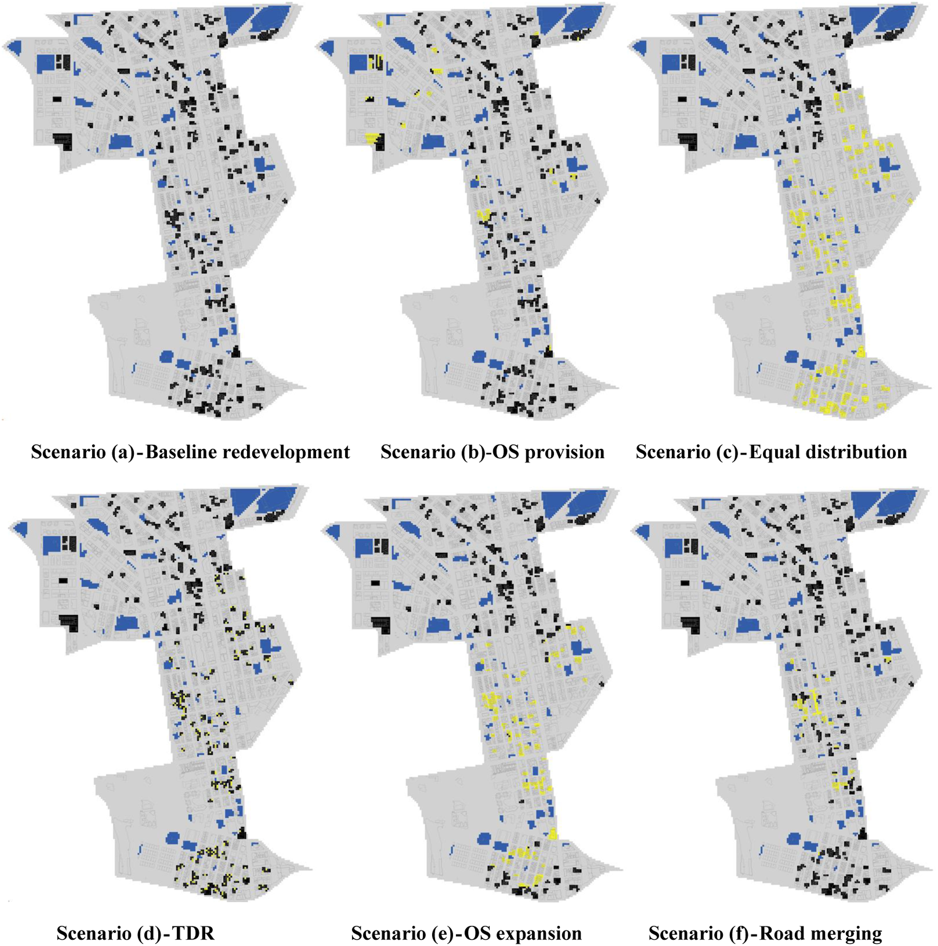
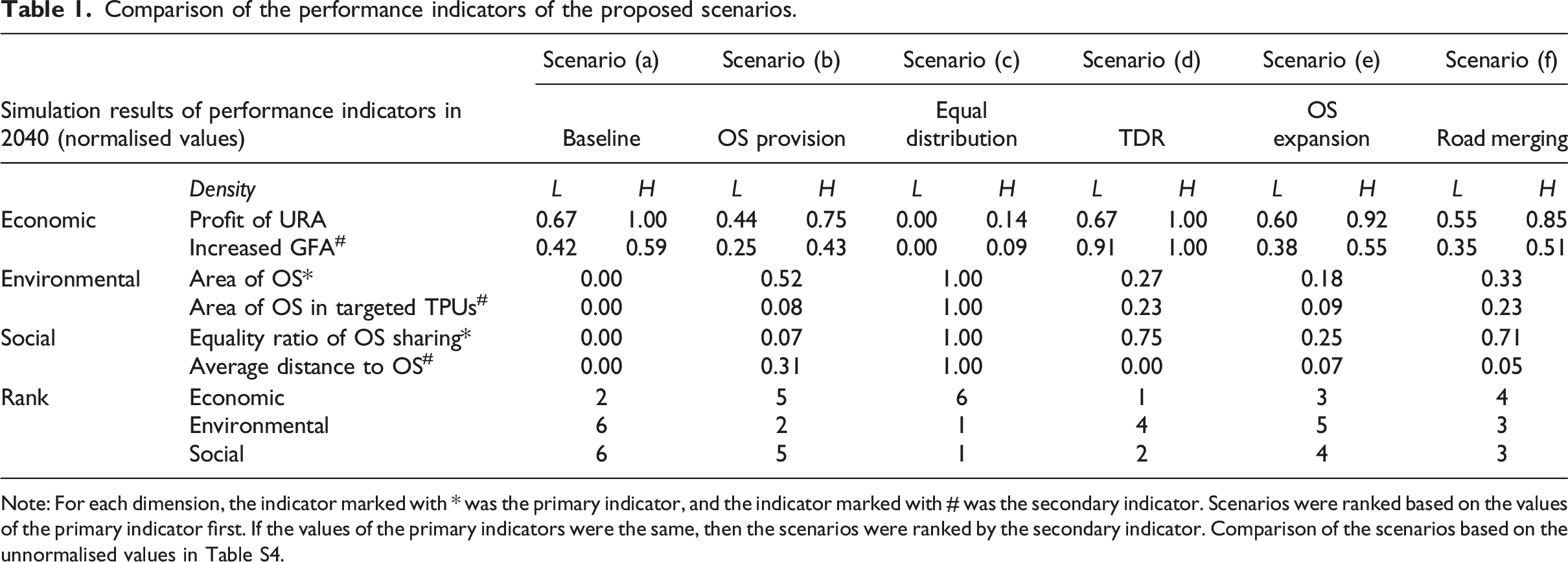
The assessment of economic performance relied on two indicators: government profit and GFA provided, with two plot ratios being designated for redeveloped buildings (including a low-density plot ratio of 8, and a high-density plot ratio of 12 for each scenario). Scenario (d) – Transferring Development Rights (TDR) – performed best in the economic dimension due to its GFA compensation mechanism. Based on the indicators in the social and environmental dimensions, Scenario (c) – Equal distribution – emerged as the most favourable scenario. Scenario (a) – Baseline redevelopment – ranked second in the economic dimension but last in the other two dimensions. This suggests that by following the existing trend, the redevelopment process was highly likely to deviate from social and environmental targets, and therefore failed to achieve sustainable urban renewal.
Synergies and trade-offs between targets
Based on the ranking of the scenarios across the three dimensions, a pairwise comparison was conducted to demonstrate the synergistic or trade-off relationships that existed between the economic-environmental, social-environmental, and economic-social performances. Figure 5 illustrates the relationships that were shown to exist between the sustainable targets of urban renewal based on the ranking of each individual scenario. The relationship between sustainable targets of urban renewal by the rank of scenarios. (i) Overall performance of the scenarios (ii) Economic-environmental relationship of the scenarios. (iii) Social-environmental relationship of the scenarios (iv) Economic-social relationship of the scenarios.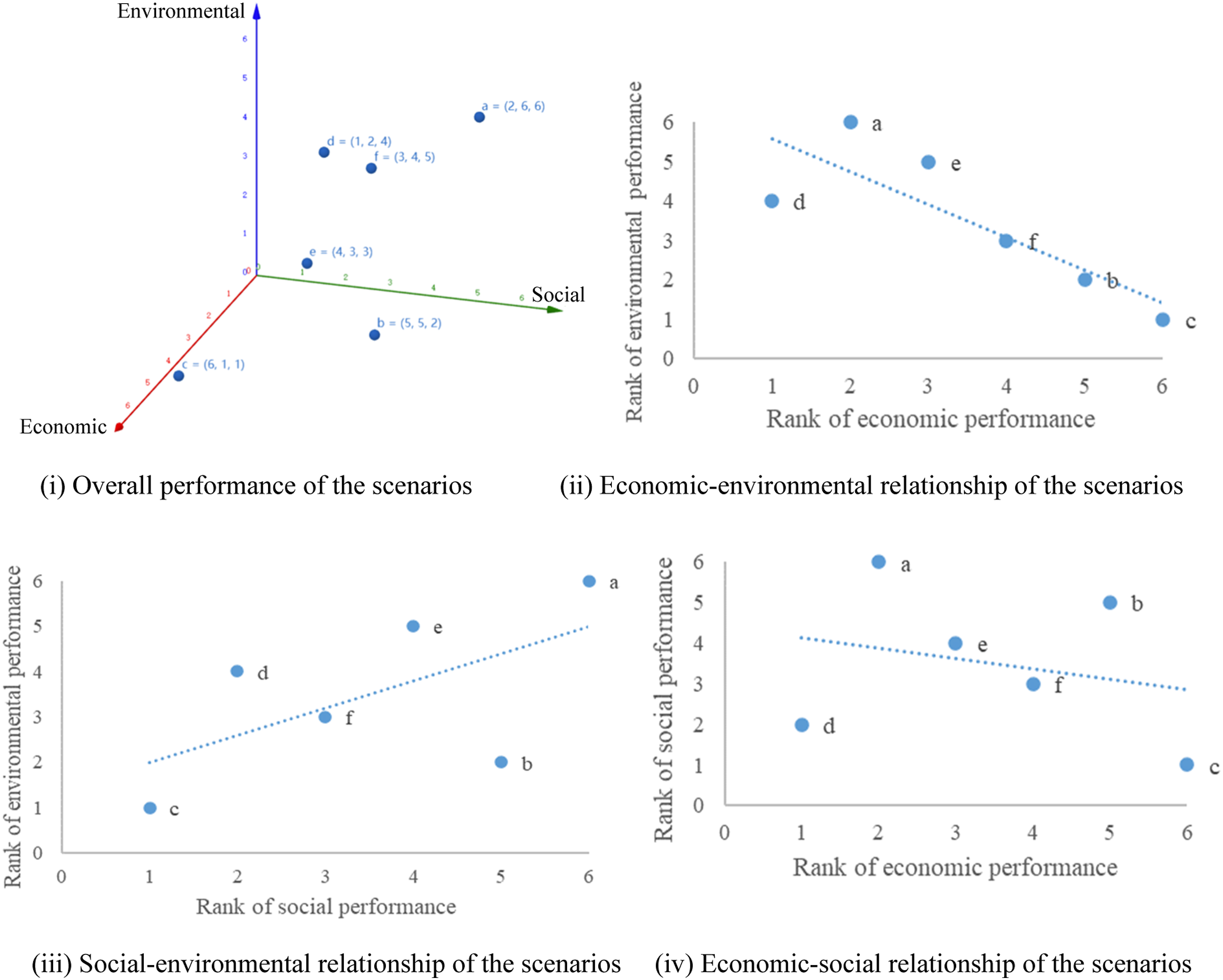
The trade-off relationship between economic and environmental targets
The negative coefficient depicted in Figure 5(ii) indicates the trade-off relationship between economic and environmental targets. Scenarios (c), (b), (f), and (e) with increased OS provision yielded lower economic returns compared with the baseline Scenario (a). This aligns with established understanding that urban development alters landscape patterns, and causes decline in ecosystem services (Wu et al., 2022). Conversely, increasing OS leads to less developable land.
If policy makers wish to achieve both enhanced economic returns and improved environmental performances simultaneously within the study area, then ‘Scenario (d)-Transfer of development rights’ would be the only option to pursue. However, the transfer of development rights is always linked to another piece of developable land because there is a need to compensate for the reduced economic gains. It follows, all else being equal, that the overall environmental performance at the city level may not improve.
Synergic relationship between social and environmental targets
According to Figure 5(iii), social and environmental targets appear to be synergistically related. Compared to the baseline Scenario (a), all other designed scenarios performed better when it came to meeting the social-environmental targets. ‘Scenario (c) – Equal distribution’ was the best in both social and environmental performances, which suggests the impact of OS configuration in mediating sustainable targets. ‘Scenario (b) – OS provision’ ranked second best in the environmental aspect and ‘Scenario (d) – Transfer of development rights’ stood as the second best in the social aspect.
Mediational relationship between economic and social targets
No significant linear relationship was observed between the economic and social ranks of the scenarios as shown in Figure 5(iv). Compared with Scenario (b) that provides OS solely based on land suitability, ‘Scenario (c) – Equal distribution’ and ‘Scenario (e) – OS expansion’, which both give more consideration to existing distributional and landscaping features, could achieve greater economic-social gains. If policy makers seek to improve both economic-social performances simultaneously then, once again, ‘Scenario (d) – Transfer of development rights’ would be the only option.
Overall, the relationships between the targets follow established trends but could be altered in scenarios with different planning strategies. i. Generally, there is a negative relationship between the social-environmental performance and the economic performance of redevelopment, though there were exceptions. ii. Land use configurations mediated the trade-offs between economic, environmental, and social gains. For instance, even under identical conditions of OS coverage, performance in social equality was enhanced when greater emphasis was placed on equal distribution. iii. Rezoning, plot ratio adjustment, and the transfer of development rights are potential policies to improve OS provision and regional sustainability without compromising the economic viability of a project.
Validation of the framework
The URA officials and experts who participated in the focus group meeting valued the insights provided by the proposed framework, particularly the land use suitability analysis and the identified relationships between the performances of the different planning strategies. The viewpoints advocated by this study align with what has been proposed in the official district study report published by URA. In the report, several planning mechanisms were shortlisted, including more flexible zoning, transfer of plot ratios, street consolidation, and an increase plot ratio incentive for additional open space (Urban Renewal Authority, 2022).
First, there was consensus that the strategies of TDR and road merging could effectively reconcile conflicts between sustainable targets, but this would require deliberate consideration in future redevelopments. Second, the idea of expanding existing open spaces when adjacent plots are redeveloped was well-received, especially if this could be undertaken with supportive policies such as TDR. Lastly, despite acknowledging the variability in urban renewal outcomes due to practical constraints and uncertainties, the participants concurred that the model offers valuable support for redevelopment decision-making because it provides long-term visions and outlines different scenarios to navigate the synergies and trade-offs that exist between sustainable targets in urban renewal.
Discussion
Factors influencing the interactive relationships among targets
The simulation results suggest key factors such as land use type, land use density, and landscape feature that impact the interactive relationships between economic, environmental and social targets. Planning strategies such as land use rezoning, plot ratio adjustment, land use reconfiguration, and TDR can influence these factors.
Land rezoning, through shifting land use types from developable to conservable uses, or vice versa, alters the buildable areas and ecological conservation areas of land use patterns. Changes to existing residential buildings or roads to OS can enhance the living environment and social cohesion but may result in economic losses (Chan et al., 2016; Du and Zhang, 2020). Adjusting plot ratios by, for instance, increasing redevelopment density, is an effective way to mitigate against the economic loss caused by the reduction of buildable land areas. In dense cities worldwide such as Taipei, Hong Kong and Singapore, the adjustment of plot ratios has been used as a value-laden governance approach to fuel redevelopment projects, assemble non-state resources, and supplement public service delivery (Lin et al., 2022).
TDR is one institutional innovation to balance the conflict between public and private interests for cities with limited usable urban land (Hou et al., 2018). Applying TDR to increase OS supply in urban renewal projects and transferring the potential floor areas to suburban projects emerges as the only scenario that meets the sustainable targets of all three aspects better than the baseline scenario.
Land use reconfiguration advocates for more equal distribution of OS. This aligns with the findings from a study that the decentralised configuration of green infrastructure and numerous small OSs is more effective in promoting social-environmental synergy (Chang et al., 2021). This provides a ‘win-win’ situation for economic affordability and social justice (Du and Zhang, 2020). Long-term planning of regional urban renewal should prioritise site selection and the scale design of OS, along with the inclusion of more people-oriented pocket OSs in old districts.
Applicability of the framework
The proposed framework explored the strategic planning of a substantial number of potential urban renewal projects, covering over 600 land parcels in the case study. It can facilitate decision-making from the outset of planning, and its applicability extends globally when it comes to screening land sites for fund allocation (Chrysochoou et al., 2012), supporting redistribution of social amenities (Beames et al., 2018) and redeveloping points-of-interests (Natapov et al., 2023). Building on existing instrumental PSSs focussing on one or several specific sustainable objectives, this framework represents an advancement via both its ability to investigate synergies and trade-offs between sustainable targets, and its illustrating of the impacts of different strategies and scenarios on long-term renewal outcomes.
In the later redevelopment stages, the simulation scenarios could guide project-specific planning regarding land use, plot ratio, and sustainability (see Figure 4). It should be noted, however, that the feasibility and externality of each individual project requires the integrating of additional data that considers or addresses multi-ownership, public participation and willingness (Chen et al., 2022; Zheng et al., 2020), as well as potential gentrification and displacement impacts (Pearsall and Eller, 2020). Public engagement and affordable housing provisions could mitigate gentrification risks (Tsang and Hsu, 2022). While this tool offers initial guidance, it should be complemented with strategic considerations during implementation to address potential negative impacts.
The framework is flexible; thereby enabling its adaption to various contexts, such as applying indices relating to ecosystem services at broader scales to facilitate greater understanding of the impacts of land use transformation (Pilogallo and Scorza, 2022). The simulation results can offer valuable insights into the interplay between different sustainable targets and inform long-term sustainable development decisions.
Limitations and further study
The simulation model sought to balance sustainable targets in urban renewal based on different datasets of land use, buildings, and demographics. However, real-world complexities such as property rights and resident participation can impact the practical implementation of renewal initiatives. Since the differences in the mean distances to OSs in the simulated scenarios of this study were not significant, the impact of OS proximity on house prices and gentrification were not considered. Further studies could incorporate these considerations and, by adjusting for house price valuations and additional factors, enhance the comprehensiveness and applicability of the framework in supporting urban renewal decision-making.
Conclusion
This study proposes a decision-making support framework to examine the interactions between economic, social and environmental goals in urban renewal. By integrating land use, building evaluation, and scenario simulation, it used Hong Kong as a demonstrative example. The modelling and results contribute to the emergent corpus of research on decision support models for sustainable urban renewal. Unlike prevailing models or frameworks that primarily focus on a single scale, the proposed framework is built upon a 3D land use model and operates concurrently at both neighbourhood and building scales; both are crucial for real-world decision-making and implementation. Additionally, it examines the interrelationships that exist between different sustainable targets by simulating different urban renewal scenarios. The findings reveal the existence of a trade-off relationship between economic-environmental targets, a synergic relationship between social-environmental targets, and a mediational relationship between economic-social targets. Planning strategies of rezoning, land use reconfigurations, plot ratio adjustment, and the transfer of development rights are, from the work herein, highlighted as effective approaches by which to maximising synergies and achieve enhanced sustainability. Theoretically, this research delineates the influential factors and pathways to reconciling conflicting sustainability targets. Methodologically, it establishes a platform that incorporates various datasets and analytical methods and presents a comprehensive lens through which to evaluate the renewal process. Practically, the proposed framework enables flexibility through scenario comparisons which gauge the impacts of different strategies, thereby facilitating long-term sustainable planning.
Supplemental Material
Supplemental Material - Synergies and trade-offs in achieving sustainable targets of urban renewal: A decision-making support framework
Supplemental Material for Synergies and trade-offs in achieving sustainable targets of urban renewal: A decision-making support framework by Anqi Wang, Wei Zheng, Zheng Tan, Mingqing Han, and Edwin HW Chan in Environment and Planning B: Urban Analytics and City Science.
Footnotes
Declaration of conflicting interests
The author(s) declared no potential conflicts of interest with respect to the research, authorship, and/or publication of this article.
Funding
The author(s) disclosed receipt of the following financial support for the research, authorship, and/or publication of this article: This research is supported by Humanities and Social Sciences Youth Foundation, Ministry of Education of the People’s Republic of China (Grant number: 22YJCZH163), the University of Manchester Personal Research and Scholarship Allowance, Research Institute for Sustainable Urban Development, The Hong Kong Polytechnic University (Grant number: 1-BBWF), and National Natural Science Foundation of China (52078448).
Data availability statement
The data supporting this study are available in the public domain or can be obtained through purchase, which includes the building construction year data from the Rating and Valuation Department of Hong Kong and ![]() [hk.centanet.com], Building data from the Architectural Services Department, B1000 digital map dataset from the Lands Department, land market data and land use data from the Lands Department, and 2016 population data from Hong Kong Census and Statistics Department.
[hk.centanet.com], Building data from the Architectural Services Department, B1000 digital map dataset from the Lands Department, land market data and land use data from the Lands Department, and 2016 population data from Hong Kong Census and Statistics Department.
Supplemental Material
Supplemental material for this article is available online.
Note
References
Supplementary Material
Please find the following supplemental material available below.
For Open Access articles published under a Creative Commons License, all supplemental material carries the same license as the article it is associated with.
For non-Open Access articles published, all supplemental material carries a non-exclusive license, and permission requests for re-use of supplemental material or any part of supplemental material shall be sent directly to the copyright owner as specified in the copyright notice associated with the article.