
Abstract
This paper investigates the geography of Facebook use at an urban-regional scale, focussing on place-named groups, meaning various interest groups with names relating to places such as towns, neighbourhoods, or points of interest. Conceptualising Facebook as a digital infrastructure – that is, the platform’s urban footprint, in the form of its place-named groups, rather than what individuals share and create using the service – we explore the location, theme, and scale of 3016 groups relating to places in Greater London. Firstly, we address the quantitative and qualitative methodological challenges that we faced to identify the groups and ground them geographically. Secondly, we analyse the scale of the toponyms in the group names, which are predominantly linked to London’s suburbs. Thirdly, we study the spatial distribution of groups, both overall and by specific types, in relation to the socio-demographic characteristics of residents at the borough level. Through correlation and robust regression analyses, the presence and activity of groups are linked to a relatively older, non-deprived, and non-immigrant population living in less dense areas, with high variability across different group types. These results portray place-named Facebook groups as communication infrastructure skewed towards more banal interactions and places in Greater London’s outlying boroughs. This research is among the first to explore and visualise the urban geographies of Facebook groups at a metropolitan scale, showing the extent, nature, and locational tendencies of large-scale social media use as increasingly ordinary aspects of how people come to know, experience, live, and work in cities.
Keywords
Introduction
The extent and nature of Facebook use as part of daily urban life, particularly at an urban-regional scale, is not well understood. Relative to other social media platforms – none created with researchers in mind – Facebook’s API and user interface often puts independent quantitative and qualitative researchers alike into a position of tactical negotiation and even combat with the platform (Gangneux and Docherty, 2018). Facebook’s image has meanwhile reached a notable low point. Academic analyses increasingly paint a dark picture of Facebook imposing its data-driven model of social life (Simanowski, 2018; Van Dijck, 2013), from which disconnection is troublingly difficult (Karppi, 2018). News media reports on Facebook have been dominated by narratives of failure and decline, around, for example, the Cambridge Analytica personal data scandal, mis- and disinformation relating to elections and the global pandemic, dwindling US teenage users (Pew Research Center, 2022), and layoffs following precipitous drops in stock value (Meta Platforms, 2022).
And yet these perceptions and discourses remain somewhat dissonant with the fact that Facebook hosts nearly three billion active daily users (see Meta Platforms, 2022). Clearly, for better or worse, Facebook remains something people depend on, even value, in their everyday lives, including in urban settings. This is a reminder that universalistic critiques have limits, since what happens on social platforms is always ‘a product of the interaction between technology, user and context’ (Willems, 2021: 1689). While using Facebook means adopting translocally standardised communication styles, designed to produce machine-readable and monetizable data (Alaimo and Kallinikos, 2019), at the same time, it is a venue for varying, local practices of communication (Halegoua, 2019; Miller, 2016).
In this paper, we seek to show this by studying the interaction of Facebook and the city, specifically some of the characteristics of Facebook as a communication infrastructure across an urban-regional geography. To do this, we examine a specialised but important subset of Facebook use: what we term place-named Facebook groups, meaning various interest groups with names relating to places such as towns, neighbourhoods, or points of interest. Drawing on an automated and manual web search, we analyse 3016 groups relating to places in Greater London, UK, for which we accessed publicly available information (e.g. group name, size, rate of activity, and description) and manually added attributes including group type and scale. Alongside recent US-focused research authored by Meta employees (Herdağdelen et al., 2022), our study is to our knowledge one of the first to explore the geographies of such Facebook groups at a larger scale.
Our analysis is informed by our diversity as co-authors. Our methodological choices and analytical inferences derive from the communities of quantitative and qualitative researchers to which we belong, and where practical, we have sought to explain our research in ways that will be meaningful across those communities. In some cases, this requires explanations which could seem basic to quantitative researchers, and in other cases, we draw on theories likely to be more familiar to qualitative researchers. Our study is perhaps an instance of what Madsen et al. (2022) call ‘the phenomenological grid’, in that we have collected semantic digital traces from place-named Facebook groups – which indicate how users of the platform conceive of and relate to places in London – and analysed these in relation to more formal geographies and statistical categories.
Our paper begins by describing where place-named Facebook groups (in general and by type) are located across Greater London’s 32 boroughs, and at which scales (e.g. citywide, suburb, and point of interest). We then move to explain and interpret the distribution of different groups via a correlation and regression analysis with geodemographic data, as well as by drawing on the insights of related empirical and theoretical work. We connect this study to previous work exploring varying representations of urban places through user-generated content online (e.g. Ballatore and De Sabbata, 2018, 2020). Conceptualising Facebook as a digital infrastructure – which allows users to contribute content about while also providing an additional ‘ambient’ awareness of daily urban life – we find that place-named groups are skewed to London’s less dense outer boroughs, which tend to be older, wealthier, and non-immigrant. We end by discussing the differentiated urban geographies of digital communication platforms as they crystallise into enduring infrastructures.
Facebook as urban communication infrastructure
While Facebook has moved well beyond a mere social networking site, becoming an interoperable ‘platform’ (Helmond, 2015), it remains principally dedicated to exchanging meaningful content. In a context of so-called ‘platform urbanism’, where entities such as Uber, Airbnb, and GrubHub increasingly help mediate transport, accommodation, and food logistics; Facebook and other social media can be distinguished as mediating urban communication (Rodgers and Moore, 2020). Our basic starting point is to conceptualise Facebook as an infrastructure, meaning that in this paper we are more interested in the platform’s urban footprint, in the form of its place-named groups, than what people share and create using the service.
Scholars are increasingly conceptualising digital platforms as both reorganising existing infrastructures and as entities becoming infrastructures in their own right (Plantin et al., 2018). Digital platforms are infrastructures in how they depend on and organise large-scale, physical systems, but also because they are ‘lightweight and portable’ forms of everyday standardisation (Peters, 2015: 32). Interestingly, Facebook has explicitly imagined and described itself as an infrastructure. In her insightful book on the platform, Bucher (2021: 58–72) describes how Facebook’s first-ever television ad in 2012 posited that the platform was like a chair (i.e. an everyday thing on which we can unthinkingly rely), or how in a 2013 interview, Mark Zuckerberg drew an analogy between Facebook and electric light (i.e. as a utility making possible myriad activities). Bringing Facebook’s own imaginaries together with scholarly conceptions, Bucher (2021: 10) argues that understanding ‘Facebook’ as an infrastructure means seeing it as a form of orientation: not only orienting those using it as a social networking tool, but as an entity taking up space, and in so doing, spatially orienting users and even non-users.
Facebook and other social media platforms are hence more than tools for communicating information. They also help constitute broader understandings around what is possible to share and know through larger scales of communicative exchange (Zingale, 2013). Individual user contributions to Facebook may seem random or discontinuous, but exposure over time and space creates conditions in which users and even non-users develop an ‘ambient awareness’ of conversations and associations mediated by the platform (Levordashka and Utz, 2016). This means social media affect participation in urban life not only through users contributing content on the platform, but also via their perceived centrality as platforms for communication or connection (cf. Villi and Matikainen, 2016).
Social media therefore have political significance for cities in ways that go beyond mediating deliberative or agonistic exchanges. They are also political in how they have often become the default infrastructure for activists, non-profits, libraries, local government and so on to communicate with urban publics or constituencies, displacing professionalised local news media in the process (Thorson et al., 2020). Through their peculiar interfaces and affordances, social platforms are also reshaping how the city is experienced or encountered in the first place, and in turn the political meanings that people might make of those experiences. Local Facebook groups, in particular, have been shown to create new daily rhythms informing how people come to know and conceive of their neighbourhood (Örnebring and Hellekant Rowe, 2021). In such groups, innumerable, often mundane conversations around ‘lifestyle’ topics such as parenting or heritage interests can often incubate more explicitly political conceptions and actions (Graham et al., 2016).
Qualitative case studies have shone some light on the dynamics of local Facebook groups, but there remains a gap in understanding their extent and geodemographic characteristics, particularly at an urban-regional scale. Meanwhile, other social platforms have been studied at larger urban scales using data science techniques. Examples include: Bingham-Hall and Law’s (2015) social network analysis of Twitter users in Brockley, southeast London, which showed a dominance of local businesses effectively broadcasting to neighbourhood residents; Boy and Uitermark’s (2017) study of 400,000 geotagged Instagram posts related to Amsterdam, which found an overwhelming dominance of exclusive events and establishments; and Ballatore and De Sabbata’s (2018) regression analysis of Twitter and Wikipedia content in Greater London, which confirmed that areas producing dense urban data tend to be relatively wealthy, young, and educated. Here, we seek to add to these and other studies with a larger-scale analysis of Facebook and its interconnections with urban life.
The specific subset of Facebook in which we are interested is place-named Facebook groups, which we define as groups having a toponym in their title, including all scales from regions to points of interest, such as ‘East London Events UK’, ‘Residents of Tufnell Park’, and ‘Windmill Brixton’. Facebook, like many social platforms, has increasingly sought to incorporate location-based affordances, often by acquiring location-sharing start-ups (Wilken, 2014). However, its ‘groups’ are locational in a different sense. Place-named Facebook groups are unlike the patchwork of overlapping yet fixed polygonal areas defining Nextdoor neighbourhoods, for example (Payne, 2017). While such groups are meaningful venues for residents living in geographic areas with the same name, they have no explicit geographical boundaries defining their membership. As they rely on user practices of naming, setting up, joining, moderating, and contributing, place-named Facebook groups are important digital traces of Facebook as an urban communication infrastructure.
Research design and methodology
The inception for this research was a related but smaller-scale qualitative study of 12 purposefully sampled place-named Greater London Facebook groups, focussing on the practices and perceptions of their administrators and moderators. To avoid selecting these 12 groups purely on our own preconceptions, we decided to generate a more comprehensive dataset of place-named Groups across Greater London. We quickly discovered that this task would be very challenging, involving both automated and laborious manual data collection and sorting. Yet we also concluded that undertaking this work could bring its own significant methodological, empirical, and conceptual insights into the relationship between Facebook and cities.
There is no simple list of groups by geographical area or spatial search facility on Facebook (or via analytics tools like CrowdTangle, owned by Meta), hence, we had to devise a novel method to conduct the data collection. Our methodology to identify Facebook groups required four steps. First, we collected a gazetteer of 1279 London place names, which included the formal geographies of Greater London’s 33 local authorities and their 626 present-day wards, and 620 informal toponyms, mostly from OpenStreetMap (OSM), selected through the ‘place’ tag. Second, this gazetteer was used in September 2022 to automatically generate Google queries. 1 This process identified about 14,300 unique public and private groups. A manual inspection of the data revealed a high prevalence of non-relevant results, especially from other geographical areas with place names of English origin. After determining that automated exclusion of these non-relevant groups was unviable, we resorted to a manual assessment, with two annotators resolving divergent classification cases, identifying 1398 relevant groups.
Our third step was to further assess our dataset of relevant groups via manual Facebook search queries, drawing a random sample of place names from our gazetteer. This revealed numerous London groups missing from Google results, leading us to undertake a further in-depth retrieval of groups by querying all gazetteer place names using Facebook’s search tool, and manually selecting relevant results. This added a further 1736 unique groups, for a total of 3134 relevant groups. Finally, we automatically collected attributes from these groups’ pages in September 2022, with 3016 groups active at the time of collection. We harvested only the following publicly available metadata: group name; description; private or public status (split respectively at 50.7% and 49.3%); date of creation; ‘place’; member count; last month posts count; and average daily posts count. We did not collect personal data, such as user profiles or messages, thereby averting any breaches of privacy, data protection, or informed consent.
Group types
As Facebook does not provide a granular taxonomy of group themes, we manually coded each group in the dataset with a group type.
2
This was accomplished by analysing each group’s name and description, and occasionally inspecting group content. The relatively small dataset allowed this process to be undertaken directly by project team members without outsourcing, with consistency assured through individual members raising queries to the rest of the team concerning potential ambiguities in the coding. A long list of group types was then refined into a smaller range. Figure 1 shows the group types and their distribution. Towards the end of our manual coding, we decided to exclude groups relating to Premier League teams, which though related to London places such as Chelsea and Tottenham, tend to have very large member counts skewed by an international fan base. Summary of group types, showing prominence in terms of percentage of total groups (N = 3016), percentage of total last month (September 2022) posts (N = ∼938,000), and percentage of members (N = 15.5 million). There were 10 small types, which included religious, cultural, political, and friends reunited groups. Note that a user can be a member of multiple groups (e.g. buy & sell are 13% of groups, but generate 54% of posts and 20% of members). For clarity, the x axes have different limits. Rows are ordered by the sum of the three values.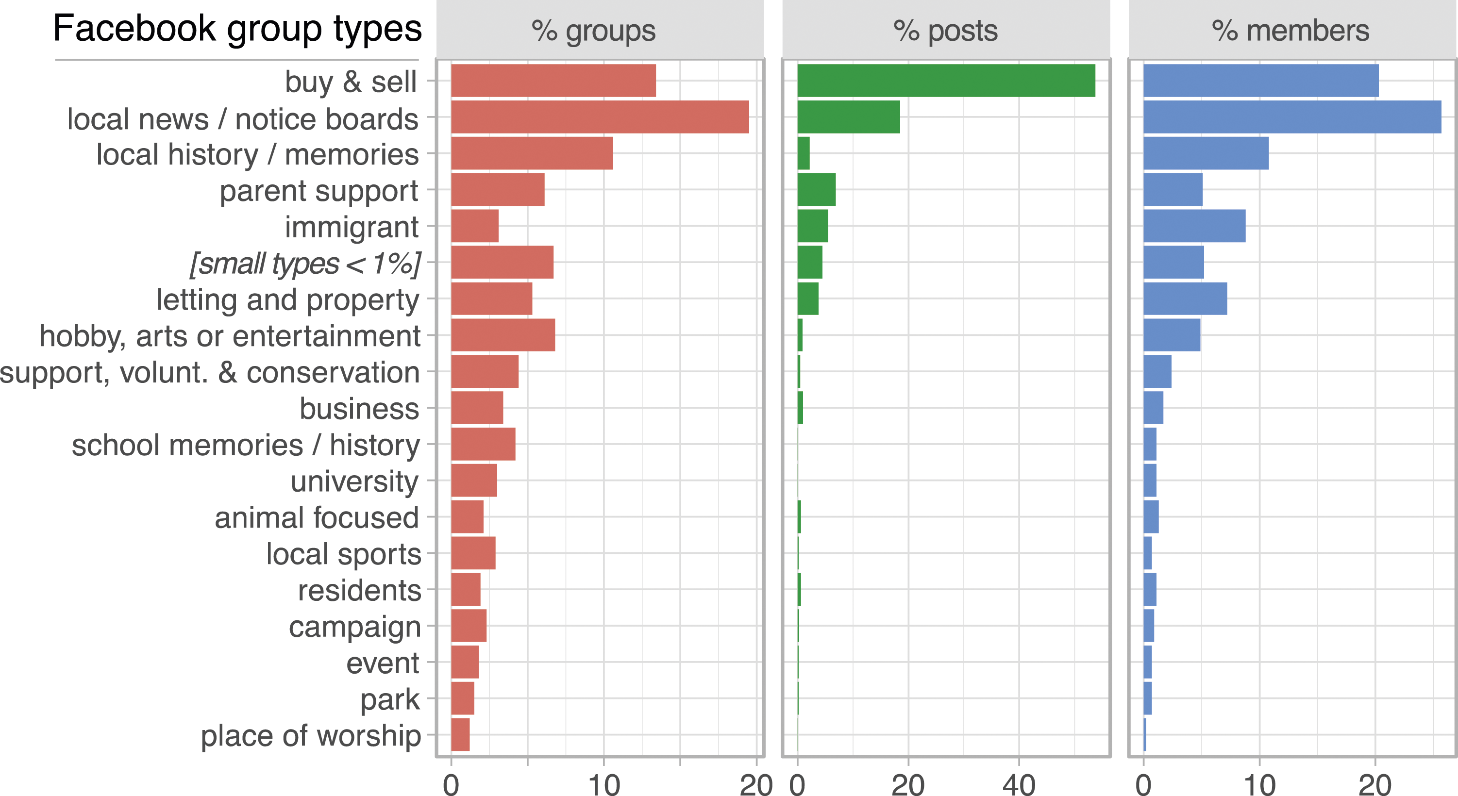
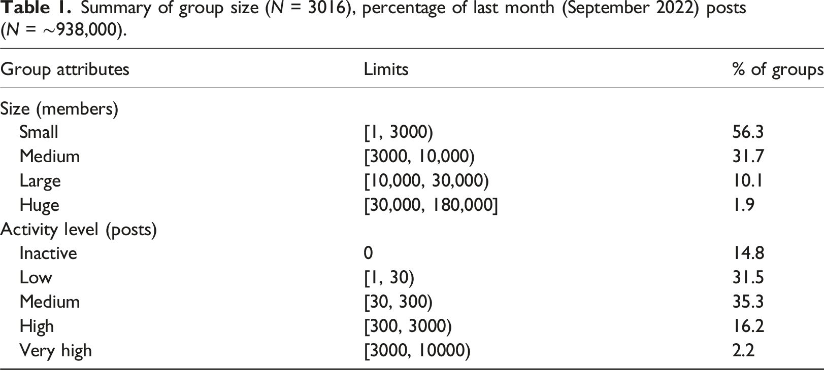
Group size and activity level
Summary of group size (N = 3016), percentage of last month (September 2022) posts (N = ∼938,000).
Group geographical ‘scale’
Summary of seven geographical scales of groups (N = 3016), including a description of data sources, examples, and the percentage of groups. When a group refers to multiple objects, we placed it into the more granular category.
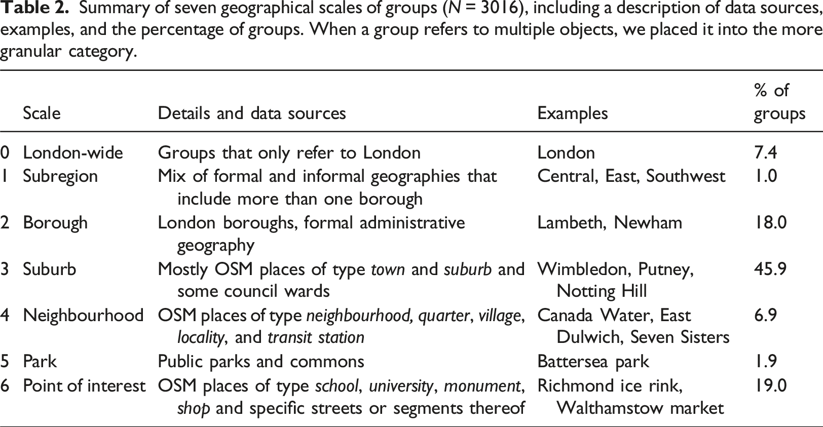
While the first three scales are relatively unambiguous (London-wide, subregion, and borough), the other four lacked such crisp distinctions and were a product of the difficult choices mentioned above. Nevertheless, we are confident in the meaningfulness of ‘suburbs’, a common informal geography of London and very prominent in our dataset (46% of groups refer to this scale). ‘Neighbourhoods’ are relatively less prominent geographical anchors (7%) and include a variety of areas smaller than suburbs and larger than individual streets. In this category, we also placed transit station names referring to the surrounding area rather than the station itself. We retained ‘parks’ as an intermediate scale (2% of groups) since these entities can be extremely large and hence a meaningful place name for several bordering areas. Finally, ‘point of interest’ was a prominent miscellaneous category (19% of groups) that includes streets, transit stations, schools, colleges, monuments, skate parks, and other informal places.
Facebook group distribution at the borough level
Greater London is only one, somewhat arbitrary, way to define ‘London’ (Paul, 2017), and its 32 boroughs 3 are coarse for statistical inference, ranging in population between 160,000 and 390,000 residents (Q1: 240,000, Q3: 320,000). Nevertheless, the geography of London’s boroughs is well understood and provides several socio-economic indicators in comparable units. Approximately 92% of the place-named Facebook groups in our dataset can be meaningfully assigned to boroughs, from scale 2 (borough) to 6 (point of interest). We discussed undertaking more granular analyses but concluded that it would be difficult with the current data. Most notably, even though we are confident in the meaningfulness of the most prevalent ‘suburb’ scale, it cannot be linked with a crisp statistical geography.
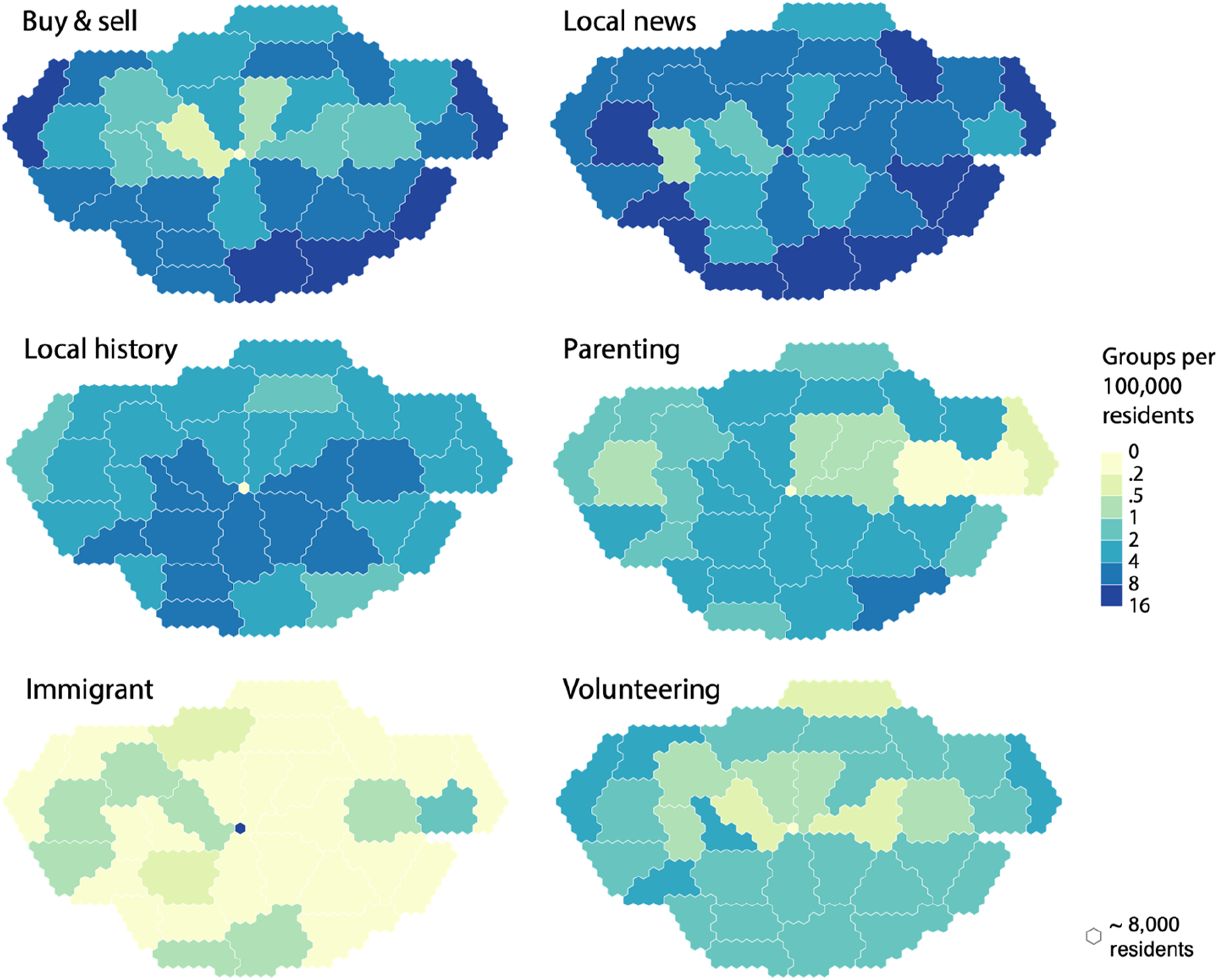
We chose two core indicators to study the prevalence of Facebook groups at the borough level: group numbers and last month post-numbers, both per 100,000 residents (see Figure 2); the former captures the existence of groups, and the latter their volume of activity. The cartograms show the boroughs based on population instead of territorial extent. It is important to acknowledge that our activity indicator in Figure 2 and Table 1 does not capture engagement, such as reactions and comments. This would be valuable but challenging to collect via the Facebook API. Nevertheless, our activity indicator shows an interesting ‘donut effect’, with more active place-named groups concentrated in outer London boroughs, which we discuss further below. Figure 3, which shows the distribution of the six most frequent types of groups, to some extent reflects this donut effect for ‘Buy & sell’ and ‘Local news’ groups, but also highlights the specificity and spatial variability across different types. Distribution of groups and posting activity in the London boroughs, visualised with geographical maps (a) and (b) and equal-population cartograms (b) and (d). Both Facebook variables are scaled by the resident population (per 100,000 people). The number of posts represent the activity in the last month at the time of data collection. Bins are defined with Jenks. Geometry source: House of Commons Library (2022). Distribution of the six top Facebook group types in the 33 London boroughs, visualised with equal-population cartograms. The bins are defined manually on a 2x function. Geometry source: House of Commons Library (2022).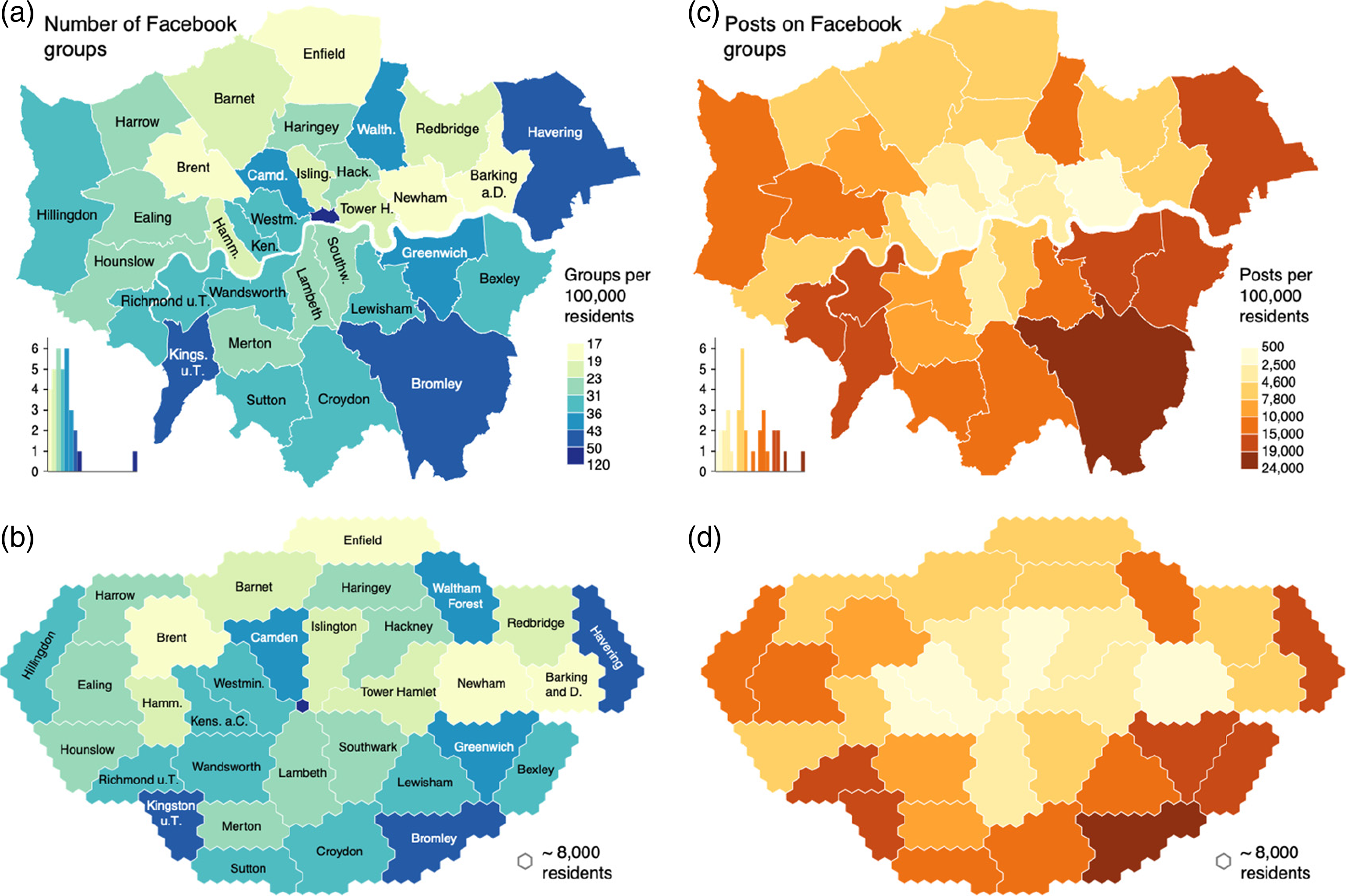
Correlating Facebook groups with socio-economic variables
Alongside analysing the typological and geographical distributions of place-named Facebook groups, we undertook a correlation analysis using socio-economic variables to better understand these distributions. Drawing on the 2011 Census and other sources, 4 we aggregated the most recent statistical data about London boroughs and identified 96 population descriptors including demographic (age, gender, ethnicity, and migration), economic (employment, income, and house prices), political (party preference), health (life expectancy), and deprivation indices. While there is a 4–11 year time lag between our Facebook group data and available socio-economic data (collected between 2011 and 2018), we consider this acceptable for our borough-level analysis.
From these 96 population descriptors, we identified the variables most likely to account for group activity, relying on the wider literature on Facebook users (e.g. Blank and Lutz, 2017; Ribeiro et al., 2020). We also excluded variables with an excessive number of missing values and ties, which would make correlation hard to assess for our small set of observation units (32 London boroughs). These variables were expressed as ratios, either as percentages or per 100,000 people, making them comparable. A complete correlation matrix was then calculated using Spearman’s rho, which measures the strength of associations. As expected, many variables were highly interrelated, and we removed covariates that were thematically related (e.g. the percentage of people aged 65 or older showed a correlation rho = 0.96 with the average age, p < .001). This process led to the selection of 10 variables, favouring the socio-economic variables with the highest correlations to our Facebook group variables and removing those that showed very weak or no correlation.
Figure 4 summarises the correlations between three Facebook-related indicators (group numbers, member numbers, and last month post numbers), number of groups that refer to a particular scale per 100,000 people, and the 10 selected variables. Population density appears to be an important descriptor, correlating negatively with the number of groups, number of members, and number of posts. As we discuss later, this negative correlation raises interesting questions about the different urban places made, in part, via such Facebook groups. When observing the groups at the different scales, ‘suburb’ groups are indeed dominant and correlate with the three indicators, while the other scales show divergent patterns. Meanwhile, place-named groups assigned to the ‘point of interest’ scale showed positive correlations with population density (0.45), household income (0.45), and particularly house price (0.62), indicating that denser, wealthier areas are more likely to have groups named for streets, transit stations, schools, monuments, or other informal and very local places. The key observation, however, to which we return in our discussion section, is the correlation between place-named Facebook groups and boroughs with less dense, older, wealthier, and non-immigrant populations. Spearman’s correlation coefficients between Facebook groups (summary and scale variables) and selected socio-economic attributes for 32 London boroughs (excluding City of London). All Facebook variables are per 100,000 people. Significance level: *p < .05, **p < .01, ***p < .001. The maximum number of ties is 3. For example, the correlation between the number of groups in each borough per capita and the percentage of population aged 65 or older is rho = 0.51 (p < .01).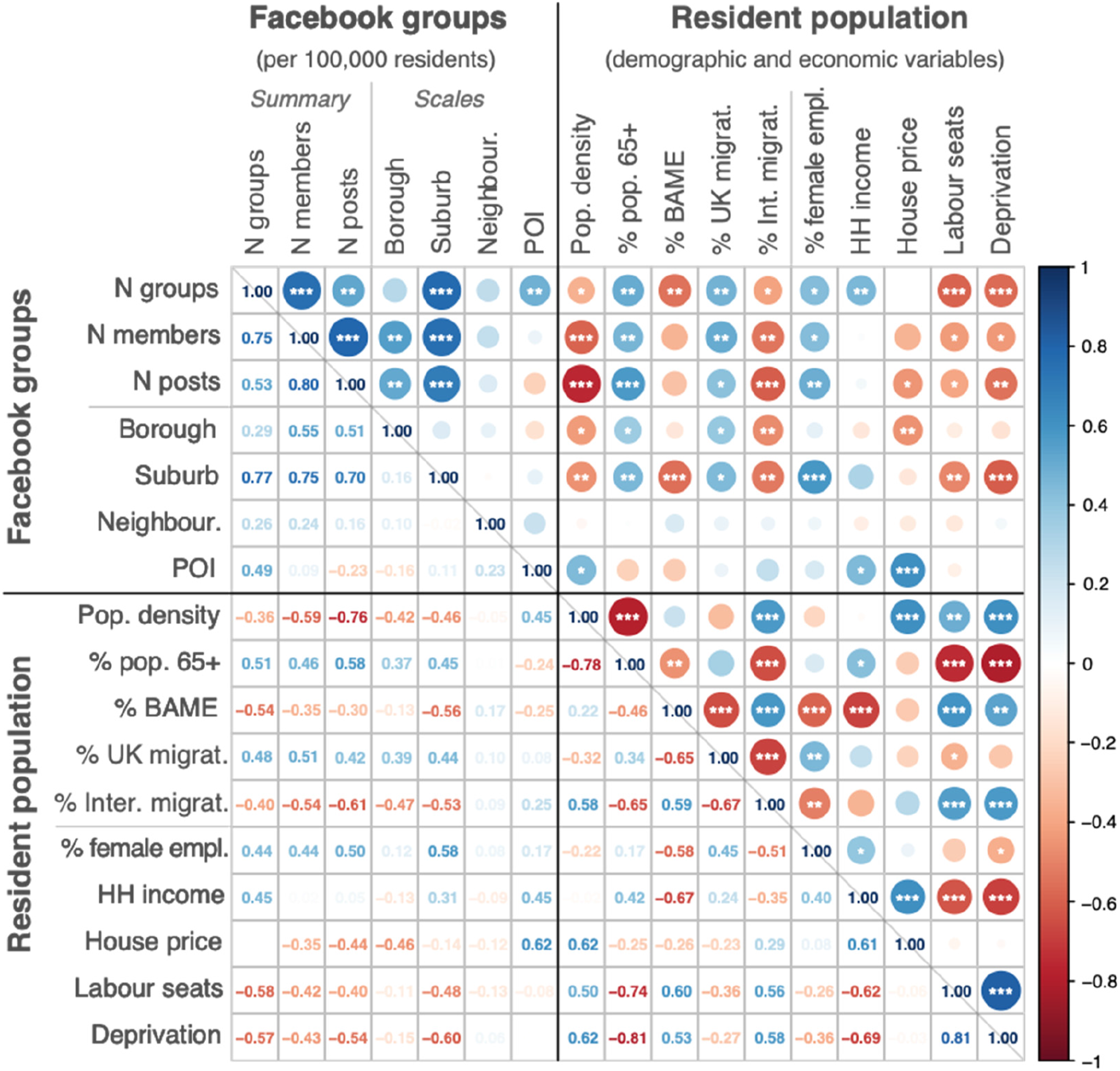
The distribution of different Facebook group types across the boroughs varies significantly, and it is worth considering correlations by type (see Figure 5). Buy and sell, local news, and volunteering groups follow the same overall pattern of being more likely in boroughs with less dense, older, wealthier, and non-immigrant populations. Some group types show more specific associations with socio-economic variables. Parenting and university groups are associated with high incomes and, to a lesser extent, with house prices. Interestingly, and potentially needing further investigation, female employment is associated with the presence of animal groups (.45), school/memory groups (0.37), and business groups (0.4). Spearman’s correlation coefficients between Facebook groups by type per 100,000 people and selected socio-economic attributes in 32 London boroughs (excluding City of London). Significance level: *p < .05, **p < .01, ***p < .001. The maximum number of ties is 3.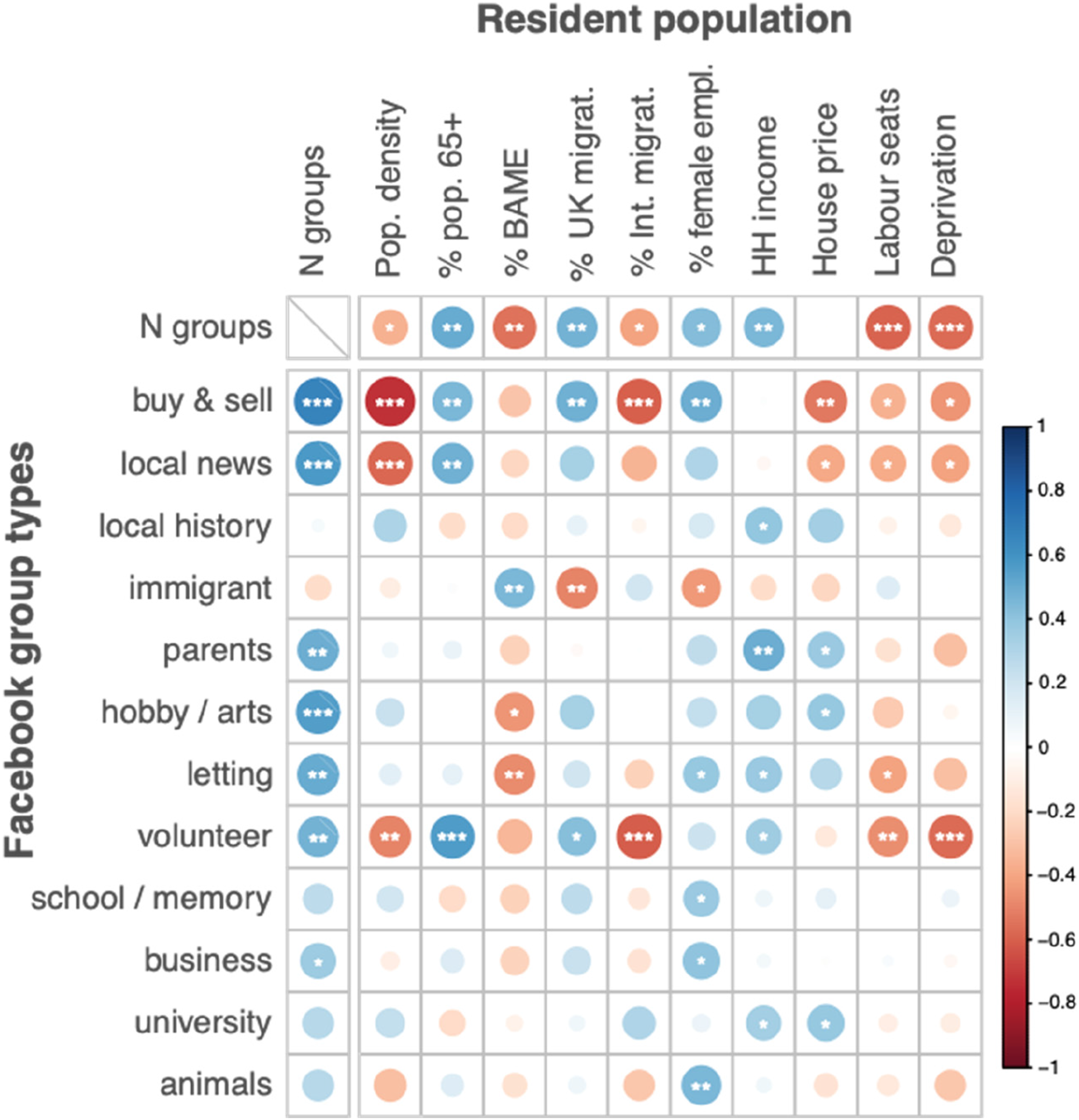
Explaining Facebook group geographies
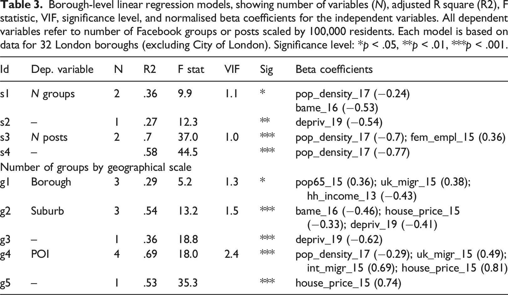
To further understand the geography of place-named Facebook groups, we devised a quantitative explanation of their prevalence and posting activity. This analysis differs from the correlation analysis, aiming to quantify a Facebook indicator based on socio-economic indicators, rather than just observing the strength of correlations. Selecting suitable variables from the correlation analysis, we built several regression models at the borough level with a Facebook attribute as the dependent variable, and socio-economic indicators as independent variables, based on 32 observations (London’s boroughs, excluding City of London). Firstly, we normalised and transformed the variables to make them usable for linear modelling. In terms of skewness, most variables are relatively symmetrical (skew in [−0.5, 0.5]); more skewed variables were transformed using a logarithmic function (internal migration, household income, house prices, and population density). Several models were built on the selected ten socio-economic variables, starting from individual variables, and then adding more variables, using Variance Inflation Factor (VIF) as a criterion to control for collinearity and overfitting.
Borough-level linear regression models, showing number of variables (N), adjusted R square (R2), F statistic, VIF, significance level, and normalised beta coefficients for the independent variables. All dependent variables refer to number of Facebook groups or posts scaled by 100,000 residents. Each model is based on data for 32 London boroughs (excluding City of London). Significance level: *p < .05, **p < .01, ***p < .001.
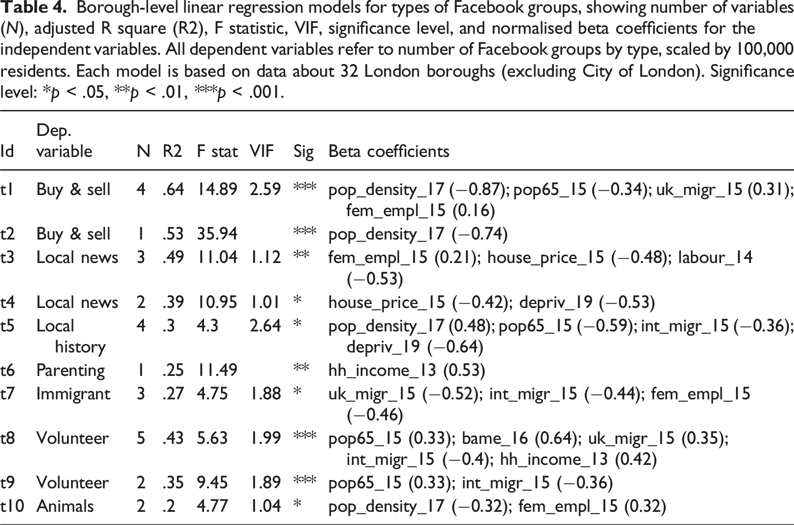
Borough-level linear regression models for types of Facebook groups, showing number of variables (N), adjusted R square (R2), F statistic, VIF, significance level, and normalised beta coefficients for the independent variables. All dependent variables refer to number of Facebook groups by type, scaled by 100,000 residents. Each model is based on data about 32 London boroughs (excluding City of London). Significance level: *p < .05, **p < .01, ***p < .001.
As a form of diagnostic, we observed the residuals of the top-performing models for selected variables (see Figure 6). Having removed City of London, no outliers emerge, indicating that the models are robust. A visual inspection of the maps suggests that no consistent spatial patterns emerge across Greater London, while some clusters appear in specific models. A group of South-Eastern boroughs also has negative residuals for buy & sell groups (model t1). By calculating global Moran’s I, we assessed that most residuals in these models do not exhibit significant spatial auto-correlation, confirming their robustness. The only notable exception is model s3 (Moran’s I = 1.67, p < .05), which predicts the level of posting activity per borough overestimating Western boroughs and underestimating South-Eastern ones. Standard residuals of selected linear models for 32 London boroughs (excluding City of London), visualised with equal-population cartograms, including adjusted R2 and Moran’s I with significance level (*p < .05, **p < .01, ***p < .001). Red (blue) areas indicate overestimation (underestimation) by the model. The bins are defined manually. Each hexagon corresponds to approximately 8000 residents. Geometry source: House of Commons Library (2022).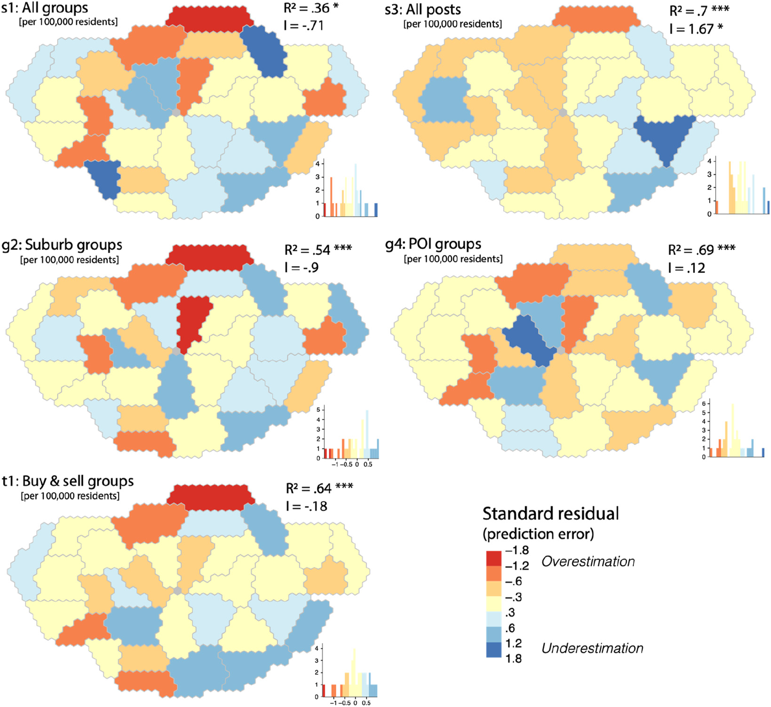
Discussion and conclusions
The size of our dataset alone (3016 relevant groups) indicates the magnitude of Facebook activity related to places in Greater London. Yet what is striking is how Facebook is a distinctively local communication infrastructure. Relatively few groups referred to London as a whole (223, or 7%), and only ∼1% of groups referred explicitly to a sub-regional scale, such as East London and Southwest London. The two largest groups in the dataset – ‘Shit London’ (∼179,000 members) and ‘Londonist Urban Oddities’ (∼157,000 members) – were London-wide. However, they were not general discussion forums, but spaces for playful, eccentric, and often mischievous discussions about London, reflecting the frequent strangeness of online behaviour (cf. Phillips and Milner, 2017). Other large London-wide groups concerned buying and selling (‘LONDON SELL BUY TRADE’, ∼125,000 members), memories of London (‘MEMORIES OF LONDON’, ∼109,000 members) or its River Thames (‘THE RIVER THAMES MUDLARKING FINDS’, ∼109,000 members), and groups convening London’s immigrant populations (‘Locuri de munca si Chirii in Londra’, ∼92,000 members; ‘ITALIANI A LONDRA di Luca Di Gregorio’, ∼80,000 members).
A higher number of groups (18%) were named for the 32 London boroughs, which deliver most municipal services, and are therefore likely to be more salient to residents. But these more formal geographies (boroughs and less commonly wards) were far less prevalent than groups reflecting more informal and local geographies such as suburbs, neighbourhoods, or parks. This reaffirms how the ‘scale’ of place-named Facebook groups are not only analytic but practical categories, meaningful to group moderators and users (Moore, 2008), and emerging from complex interactions between ‘elective’ and historically rooted forms of belonging (Savage, 2014: 30). Here, place-named Facebook groups likely reflect how media uses more generally are informed by material stakes in and affective attachments to local places (Aldridge, 2007: 9).
Where such place-named groups are is also significant: as mentioned earlier, there is an observable ‘donut effect’, in which more active place-named groups appear to be concentrated in outer London boroughs. In our correlation and regression analysis, we were able to associate and statistically explain how proportionally more place-named Facebook groups and posts can be linked with populations in Greater London boroughs with less dense, older, wealthier, and non-immigrant populations. The number of place-named Facebook groups per 100,000 people was negatively correlated with population density (−0.36), proportion of Labour seats (−0.58), and deprivation (−0.57), and positively correlated with population aged 65 or more (0.51), domestic migration (0.48), percentage of female employment (0.44) and median household income (0.45). The number of posts in these groups follows an overall similar pattern, but with stronger negative correlations to population density (−0.76), international migration (−0.61), and median house prices (−0.44). This overall pattern where place-named Facebook groups and posts are more likely associated with Greater London’s outer boroughs is also reflected in specific group types, such as buy & sell, local news, and volunteering groups. The case of volunteering groups in particular merits further research, as this suggests a possibility that place-named mutual support Facebook groups, often established during the COVID-19 pandemic, were less likely in areas of potential need (i.e. boroughs with denser, more deprived, or higher immigrant populations).
While the term ‘suburban’ might be used to describe where in Greater London we found a concentration of more active place-named Facebook groups, we have avoided doing so. Our rationale is that the term suburban has too many conflicting connotations (Forsyth, 2012), perhaps owing to the increasingly ‘kaleidoscopic’ nature of suburbs globally, ranging from privileged to marginalised, homogenous to diverse, and individualistic to communal (Keil, 2013). 5 Nevertheless, our research provokes interesting questions around the more banal social interaction and place-making Facebook appears to support in places often labelled suburbs, contrasting, for example, with the exclusive and avant-garde urban places Instagram users appear to elevate (Boy and Uitermark, 2017). Suburbs occupy an ambiguous position between counterpoised ‘urban’ and ‘rural’ localities in classic sociological accounts, such as Tönnies’ (2001/1887) distinction between an urban Gesellschaft (society) and rural Gemeinschaft (community), Simmel’s (1950/1903) observation that experiencing the metropolis necessitates a ‘blasé attitude’ not seen in rural settings, or Goffman’s (1963) postulation of a ‘nod line’ delineating social expectations in more and less populous places for mutual acknowledgement. Further research might help better understand whether it is precisely these ambiguities that make place-named Facebook groups so attractive in urban areas like our outlying Greater London boroughs, while being less numerous and active in more central areas. It may be that this particular form of social media help redress a lack of community among more atomised individuals in such outlying areas; on the other hand, it may be that the characteristics of such areas (e.g. less dense, older, wealthier, more homogenous culturally) makes such place-named groups more likely to be venues of social media exchanges. 6
Hence, even as Facebook brings communicative standardisation to how people relate to local places, our research suggests it also encourages urban differentiation, which we show through our analysis of the extent, nature, and locational tendencies of place-named groups in relation to geodemographic characteristics. When connected to places, Facebook potentially supports an ever more finely tuned differentiating of people and lifestyles by location (De Waal, 2014). Further comparative research might explore whether, in urban regions of different sizes and in different global contexts, place-named Facebook groups are more prevalent and active in relation to older, non-deprived, and non-immigrant populations living in less dense areas – as we found for Greater London – or if other patterns emerge. The quali-quantitative research approach we presented in this paper makes such comparative research more possible. We have outlined a four-step methodology for ethically identifying and collecting publicly available metadata for place-named groups, combining automated queries with careful manual data inspection, cleaning and, as needed, retrieval. We have also shown the benefits of close qualitative attention to analytic categories (e.g. in verifying the practical meaningfulness of scalar group categories, which will vary) in combination with correlation and robust regression analysis for exploring the urban geodemography of social media.
In urban contexts like London, social platforms such as Facebook are increasingly seen as alternative data sources for better evidencing – in conjunction with census or other data – patterns such as urban social integration (e.g. Krasodomski-Jones et al., 2018), or better apprehending local topics of public conversation (Moss et al., 2015). While social media can in those ways be a valuable instrument (or proxy) to measure and understand more general urban trends and topics, our research shows the practical value of measuring and understanding the presence or footprint of social media itself as an urban object (Moore and Rodgers, 2020; cf. Zeller, 2017). This is a valuable insight for academic researchers as well as local governance practitioners and policymakers. 7 We have shown how, in Greater London and potentially other urban contexts, Facebook encourages the user generation of communicative arenas distinct from formal jurisdictions, and more likely to be associated with informal, locally significant place names. In addition, we have shown how geodemographic characteristics can help explain where in Greater London such groups identifying with named places are more likely, as well as their varied and often uneven tendencies to fuse with various topics, concerns, and types of interactions. These insights can help indicate for policymakers basic gaps or inequalities needing further investigation, such as our earlier observation that volunteering groups were less likely in London boroughs with potential need for such mutual support networks. In these ways, data related to place-named Facebook groups can show the broader significance of social media as communication infrastructures shaping, however unevenly, how people come to know, experience, live, and work in cities.
Footnotes
Declaration of conflicting interests
The author(s) declared no potential conflicts of interest with respect to the research, authorship, and/or publication of this article.
Funding
The author(s) disclosed receipt of the following financial support for the research, authorship, and/or publication of this article: This work was supported by a grant from Facebook Research (2480566308870065). The research undertaken under this grant was unrestricted, with no oversight by, nor privileged data access from, Meta Platforms, Inc. (formerly Facebook, Inc.).
Data Availability Statement
This code and data for this paper is available in accordance with relevant ethical and data protection guidelines at https://github.com/andrea-ballatore/facebook-city. It will also be accessible in open-access data repositories at the main and second authors’ university institutions (at King’s Open Research Data System (KORDS) https://kcl.figshare.com/; and Birkbeck Data Repository (BiRD) ![]() ).
).
Notes