
Abstract
This study examines the impact of the morphological characteristics of plots in the Helsinki Metropolitan Area (HMA) on the retail landscape, with a focus on understanding the ways in which the morphological characteristics potentially influence the distribution, agglomeration and diversity of retail businesses. Although frequently underestimated in contemporary placemaking practices, this research emphasizes the role of the dual nature of plots as an element of urban form and an element of control over the retail landscape of the city. In this sense, the role of the morphological characteristics of plots in shaping the retail landscape of the city was investigated. The compositional (size, frontage ratio) and configurational (integration, betweenness, frequency) features of the plot in the HMA (n = 77,736) were measured. Thereafter an unsupervised two-step clustering method was applied to reveal the subtle morphological regions through plot patterns. Computational plot characterization with open data sets yielded six plot types having different morphological characteristics and geographic distribution patterns. The spatial capacities of each plot type for retail distribution, agglomeration and diversity were then analysed and compared. This research argues that the interrelationship of the dual nature of plot plays an important role in placemaking processes. The results suggest that the spatial capacity of plots to accommodate street-based retail clusters is improved with spatially integrated, fine-grained urban fabric with independent micro-businesses involving a diversity of uses and actors. The study argues that these spatial conditions might also increase retail resilience and contribute to the vitality and viability of the retail landscape.
Introduction
In addition to being an economic activity, retail development has a significant meaning for the physical and functional structure, and for the social life of the city. Their concentration attracts other correlating functions and is conducive to the occurrence of various social and economic events. Granovetter (1973) emphasizes that the role of commercial spaces in encouraging the social interaction that emerges from unplanned encounters through the streets is crucial for a city. In this regard, the retail landscape is claimed to offer a subject for critical discussions in the development of contemporary cities. Within this context, this research aims to understand the interrelations between the economic and physical features of the space by studying plots and retail areas in the Helsinki Metropolitan Area (HMA). Specifically, the study examines how the morphological characteristics of the plot system may affect the retail landscape of the HMA.
Kropf (2018) conceptualizes the relationship between people and space in terms of activity and control. While owning land gives an individual the right to control the use and occupation of a plot, activity occurs when people make use of the facilities on the plot. On the other hand, the physical relationships between different urban forms can also influence the control and activities of plots. Plots, as a nexus, have a dialectical relationship with other urban forms. The plot system not only defines the road network with its front edges, but also shapes the built environment through the design codes it specifies. This can lead to different typologies for buildings, streets, and eventually, diverse activities. In this context, the plot can be considered as the element of physical form and an element of control which conditions the property relation and functional characteristics of the city. Therefore, it is argued that the plot system provides a useful framework for understanding the variations in the socio-economic context of a city.
However, the role of plots is often underestimated in contemporary placemaking practices. It has been argued that the influence of modernist planning approaches and the New Urbanism movement continue to downplay the importance of plot systems (Porta and Romice, 2014). Subdivision strategies for real estate in the suburbs have often shifted from plot-based to block and district-based development, leading to differences in the morphological characteristics of plots in terms of use, scale, proportion and density compared to those in historical areas (Bravo, 2016). Large-scale spatial development trends in the suburban area often lead to a monoculture of uses, threatening the viability of micro-scale uses (Love and Crawford, 2011). Robbins (1998) argues that small retail businesses are unlikely to thrive in such spatial patterns.
The urban core of the HMA developed in a compact form characterized by dense growth patterns until 1950s. After the 1950s, the HMA was developed with large residential suburbs connecting the city centre with rail and highway corridors. The HMA has also experienced a retail oligopoly, with chain stores dominating the market and independent retail declining (Hewidy and Lilius, 2022). In parallel with these processes, a new approach to the plot system has dominated the spatial structure of the city and the existing practices in the design and development of retail areas have changed. The emerging market forces and the new spatial practices have redefined the role of plots as an element of control and urban form. In this regard, this study questions the multiple nature of the plot that might influence retail development in the HMA. To that end, the paper aims to uncover the different plot patterns in the study area and discuss the retail landscape they influence.
Morphological dimension of retail geography
Many location theories have focused on the spatiality of retail areas primarily from an economic perspective, often overlooking the role of urban form in their analyses. Davies (1968: 92) agrees, stating that earlier studies have primarily recognized functional areas and treated the morphology of these patterns only incidentally. Saraiva and Pinho (2017) also note that the morphological aspect of commerce has been poorly addressed in the literature so far. The essence of these criticisms lies in the distinction between the functional and morphological dimensions of the spatial structure. However, the plot provides the potential circularity between these two dimensions due to its ability to determine the physical form and the activity.
On the other hand, a new body of literature has emerged that discusses the various morphological aspects of the cities and their relationship to economic activities. Hillier's (1996) theory of movement economy provides a framework for studying the interrelationship between the structural morphology of the street system, attractions in the space and pedestrian flow. Research in this area has investigated a range of issues, including: the level of accessibility of the street layout and the spatial distribution of retail businesses (Van Nes, 2005; Porta et al., 2009, 2012; Wang et al., 2014; Fusco et al., 2015; Paroli and Maraschin, 2018; Araldi and Fusco, 2019; Han et al., 2019; Lin et al., 2018); the accessibility of retail spaces based on transportation modes and travel types (Tsou and Cheng, 2013; Buzzacchi et al., 2021); the impact of street accessibility on rental values and the distribution of retail businesses (Adebayo et al., 2019); and comparative studies of urban fabrics with different structural morphologies (Chiaradia et al., 2012; Omer and Goldblatt, 2016). These studies typically take the street network as the unit of analysis and focus on the accessibility-related features of urban form to understand the spatiality of retail uses.
It is moreover important to include the compositional elements of urban form in analyses to provide a fuller understanding of retail geography. Sevtsuk (2020) identifies a number of compositional elements that can influence retail distribution. Araldi (2019) and Oliveira (2021) propose various assessment tools for examining the relationship between urban form and economic activities. Moreover, research in this area has investigated a range of issues, including: different block typologies and retail distribution (Joosten and Van Nes, 2005; Hausleither and Berghauser Pont, 2017); the permeability of streets and commercial activities (Villian, 2011); different plot typologies and retail distribution (Bobkova et al., 2019); the influence of the density and accessibility of the building fabric on retail development (Vitalli and Lena, 2016); and the impact of street structure on retail frontal density (Scoppa and Peponis, 2015). These studies often use the building fabric, block and plot layouts as the main unit of analysis. In the context of the recent literature, it can be argued that theoretical efforts taking the streets as the unit of analysis tend to focus on the configurational aspects of urban form, while the compositional features, based on plots, are (relatively) less discussed.
Plots as the unit of analysis
The plot is the principal component of the spatial and economic dimension of space. In addition to being a basic element of the urban form (Moudon, 1994; Whitehand, 2001), the plot is also considered the main unit of property (Conzen, 1960; Moudon, 1986). This dual nature gives the plot regulatory power over the physical elements of spatial practices, such as buildings and streets, and makes it an institutional tool for determining land use in planning (Kropf, 1997). While the multidimensional nature of the plot may make its definition ambiguous (Conzen, 1960), it has the ability to subsume the economic, physical and social aspects of the city.
In the theory of spatial capital, Marcus (2010) identifies the role of plots in measuring the efficiency of space in terms of economic diversity. The theory of spatial capital discusses the influence of the topological and geometric features of plots on spatial diversity and theorizes that the size, accessibility and density of plots affect the presence of actors and economic variety in the space (Marcus, 2010). Webster and Lai (2005) also examine how the shape and structure of plots influence the distribution of economic functions, focussing on the spontaneous changes in property rights. Webster and Lai (2005) argue that smaller, more regularly shaped plots tend to emerge in urbanized areas due to the impact of economic specialization. From a similar perspective, several studies have also discussed the influence of plot structure on socioeconomic processes (Danenberg et al., 2018; Marcus and Bokova, 2019; Bobkova et al., 2019; Sevtsuk, 2020; Oliveira, 2021).
Plots with distinctive morphological characteristics create diverse spatial patterns in the urban fabric, and ultimately, different potentials for diverse functions. In this sense, recognition of character areas in the urban fabric is significant for understanding the potential and measuring the affordances of space (Hausleitner and Berghauser Pont, 2017). Ever since the conceptualization of the morphogenetic approach (Conzen, 1960, 1975), a large body of literature has emerged focussing on the concept of the morphological region (Oliveira and Yaygin, 2020). Birkhamshaw and Whitehand (2012) highlight the importance of reading the urban form through character areas and emphasize the need to specify and delineate character areas for more effective planning practices.
With the advances in computational methods, it has become possible to classify urban patterns (Dibble et al., 2019; Bobkova et al., 2021; Fleischmann et al., 2021; Venerandi et al., 2022). Identifying character areas using related indicators enables planners to understand the subtle morphological continuities and ruptures in the heterogeneous spatial patterns of cities, and to develop efficient spatial interventions for sustainable urban development (Çalışkan et al., 2022: 3). In this sense, this study argues that recognizing plot patterns in the urban fabric affords an understanding of the functional capacity of space and the promotion of sustainable retail systems.
Methodology
This research hypothesizes that the plot structure, as a key element of the urban form, has certain spatial characteristics that are conducive to retail activities. To test this hypothesis, plots in the HMA (n = 77,736) were chosen as the unit of analysis, and dependent and independent morphological variables were measured.
Dependent variables.
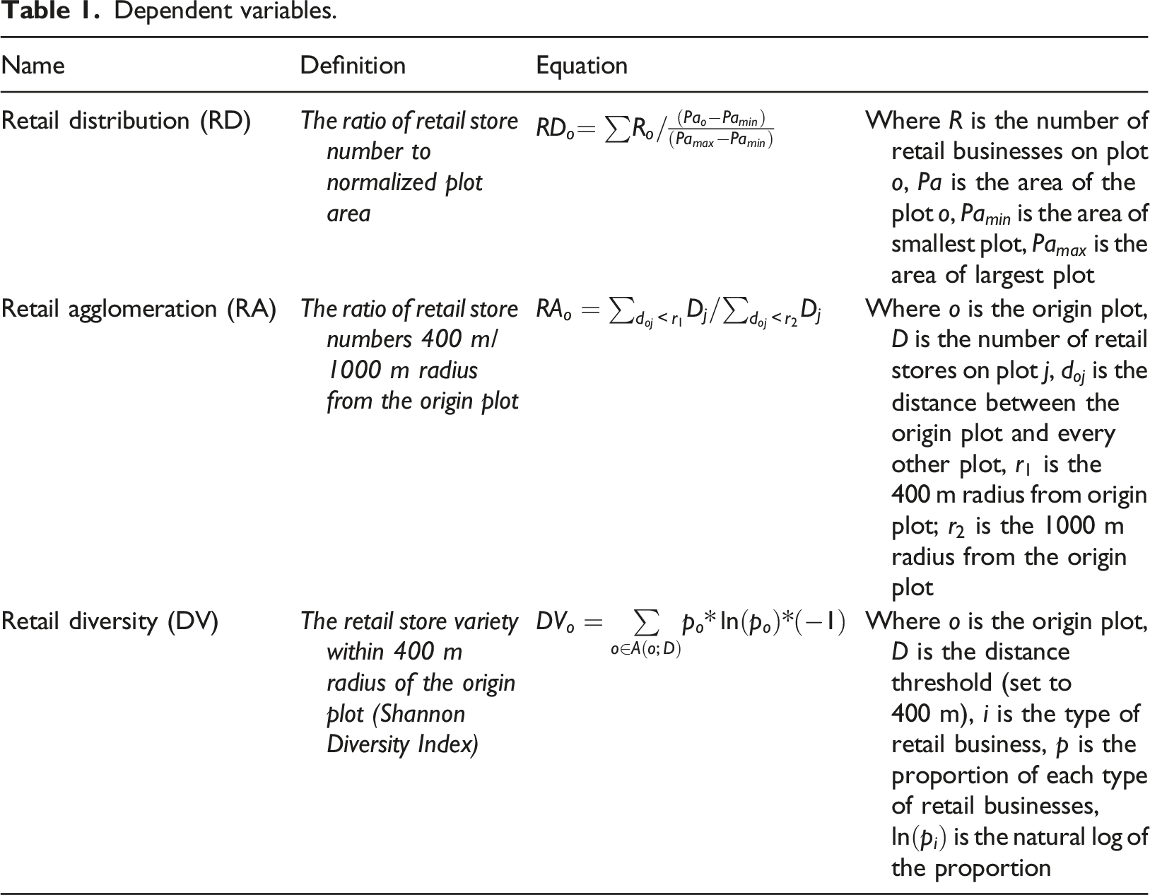
Independent morphological variables.
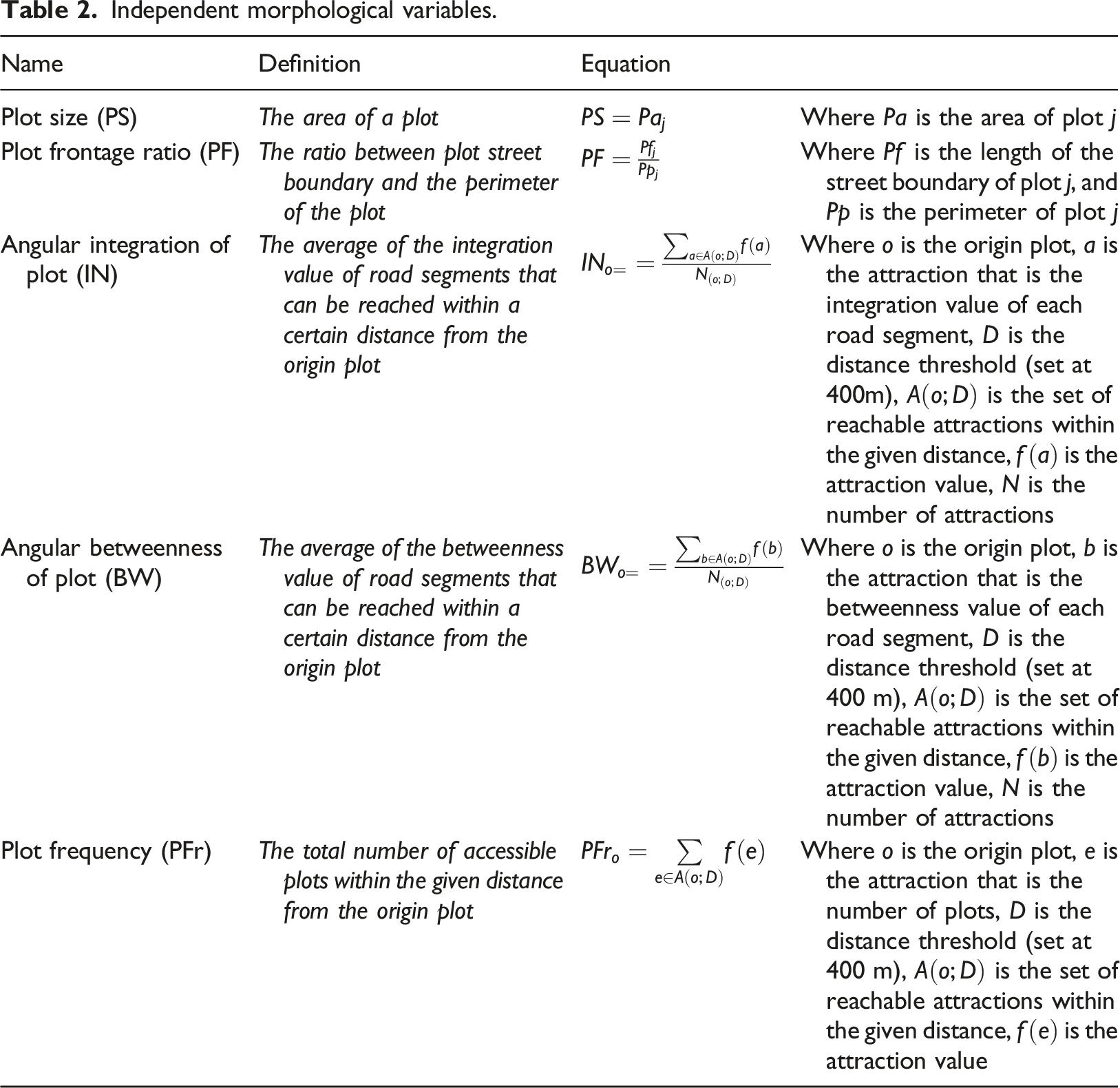
The configurational features of each plot were measured using indicators of betweenness, integration and plot frequency. These accessibility-related metrics were calculated based on a five-minute walking distance (r=400 m). It is conceded that there are some plots having retail stores that can be accessed by motorized vehicles with a larger service radius. However, this study focused on walking distance and treated plots equally by using a fixed distance of 400 m as the service radius for accessibility calculations to maintain consistency and comparability across all plots. The betweenness value reflects the centrality of plots for through-movement within the given distance, which is important for retail businesses as they tend to be located in areas with a high potential to attract unplanned-impulse customers (Buzzacchi et al., 2021). Likewise, a higher value of the integration index indicates a more central location, which is more advantageous for retail (Porta et al., 2012; Wang et al., 2014; Paroli and Maraschin, 2018). In addition, a higher plot frequency indicates a greater subdivision of the land into plots. A high number of plots within a given area provides the potential to accommodate a variety of uses, which may improve social vitality for retail (Marcus, 2010; Hausleitner and Pont, 2017; Araldi, 2019).
On the other hand, the compositional features include plot size and plot frontage ratio. The size of the plot affects the spatial capacity (Marcus, 2010) and the level of economic specialization of the urban space (Webster and Lai, 2005). The plot frontage, or the transitional edge of the property where socio-spatial interaction takes place, is believed to promote social vitality (Thwaites et al., 2020). Besides, Bobkova et al. (2019) argue that a smaller frontage ratio is associated with a higher concentration of economic activities.
The processing toolbox of QGIS software was used to measure the compositional patterns of urban space. The Place Syntax Tool 4 was utilized to measure the configurational features for each plot. After running spatial analyses, the statistical measures were computed in SPSS software.
Study area and data
The Helsinki Metropolitan Area (HMA) is home to 1.2 million people and covers 770 km2. It consists of Helsinki, Espoo, Vantaa and Kauniainen and is the most populous region in Finland, with over 20% of the country's total population.
Central Helsinki is the prime rental zone in the HMA, despite the increase in the number of shopping centres outside the city centre. According to the Helsinki City Plan 2050, future urban growth will be planned by expanding the city centre northward alongside the new boulevards, providing infill development in existing districts and new development in brownfield lands and decommissioned areas (Helsinki CPD, 2013). The anticipated population growth will increase the demand for new retail areas and the need for effective design strategies.
The data for this research were obtained from three sources. First, the Helsinki Region Environmental Services Authority provided vectorial drawings of buildings in the HMA through its open map service. 5 Second, property lines of plots (n = 77,736) were obtained from the open map services of the municipalities in the HMA. 6 Third, road centre lines and the locations of retail businesses were retrieved from OpenStreetMap. 7 Based on the European Classification of Economic Activities (NACE, 2008), a total of 7464 retail businesses were classified into seven categories (see Figure S1 in Supplementary Materials).
Results
Computational plot characterization
Morphological characteristics and sizes of six plot types.
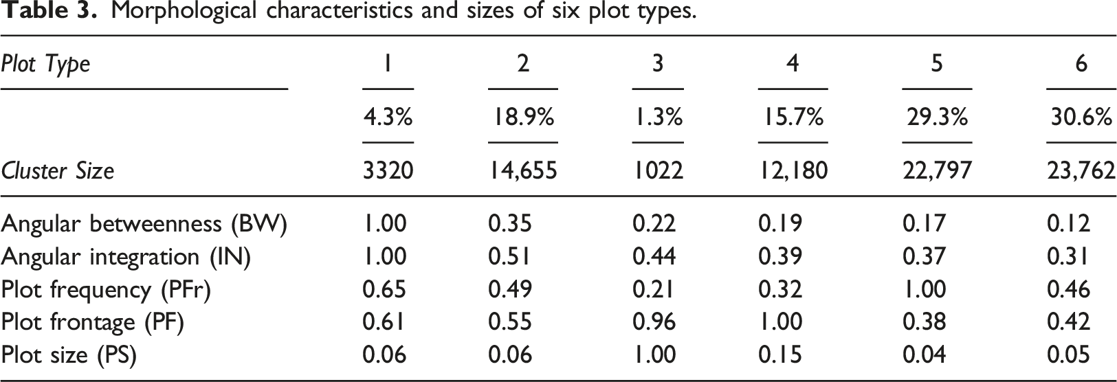
The quantitative results of the systematically classified plots were evaluated to delineate their morphological typologies. Although certain morphological indicators demonstrate similarities for some types, the aggregation of features resulted in specific characteristics for each plot type (see Figure 1 and 2). Each plot type was also compared according to demographic indicators, built densities and public transport accessibility indicators (see Figure S3 and Table S2 in Supplementary Materials). Radar charts showing the morphological characteristics of six plot types based on five variables. Overview of the plot types in the Helsinki Metropolitan Area.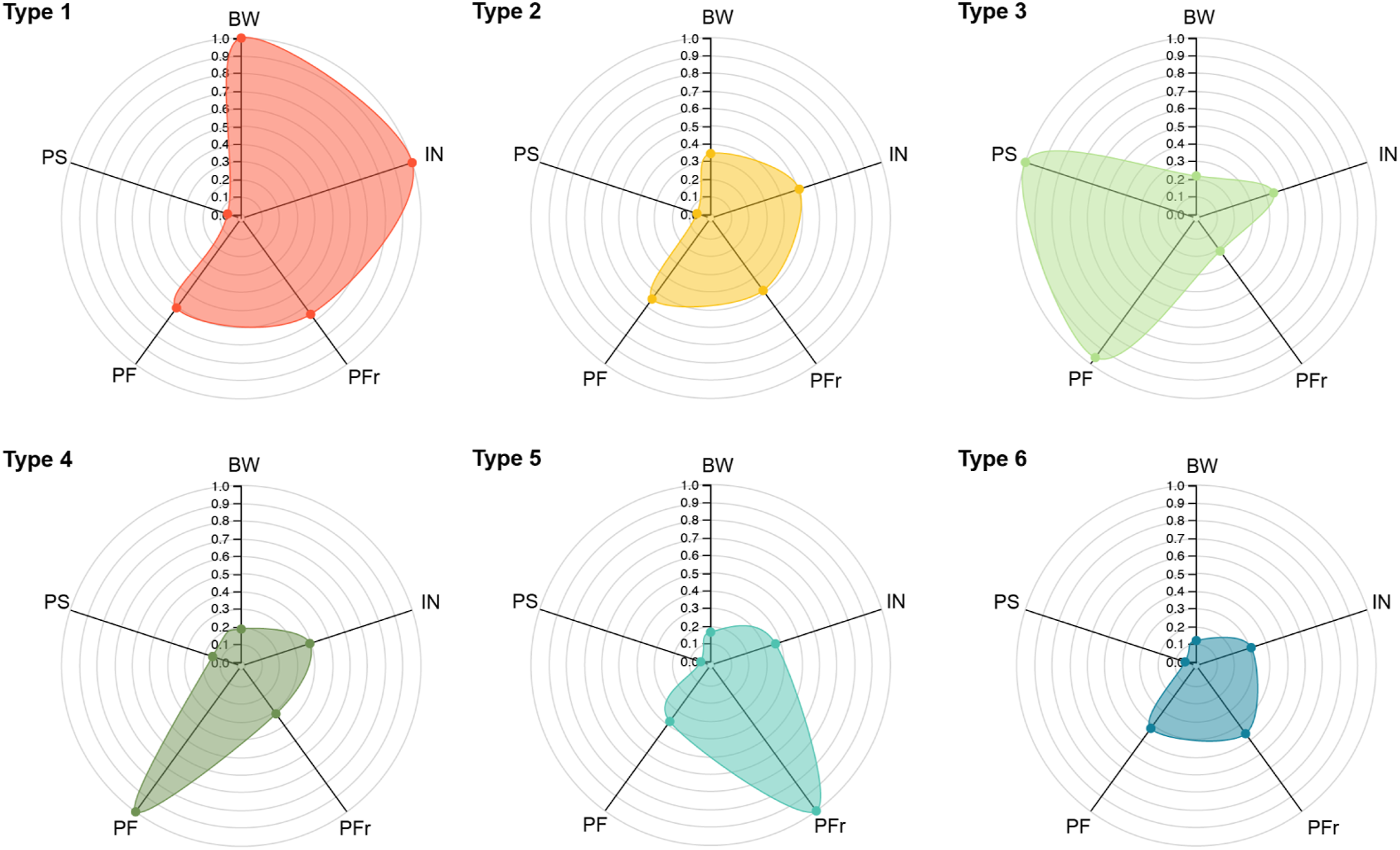
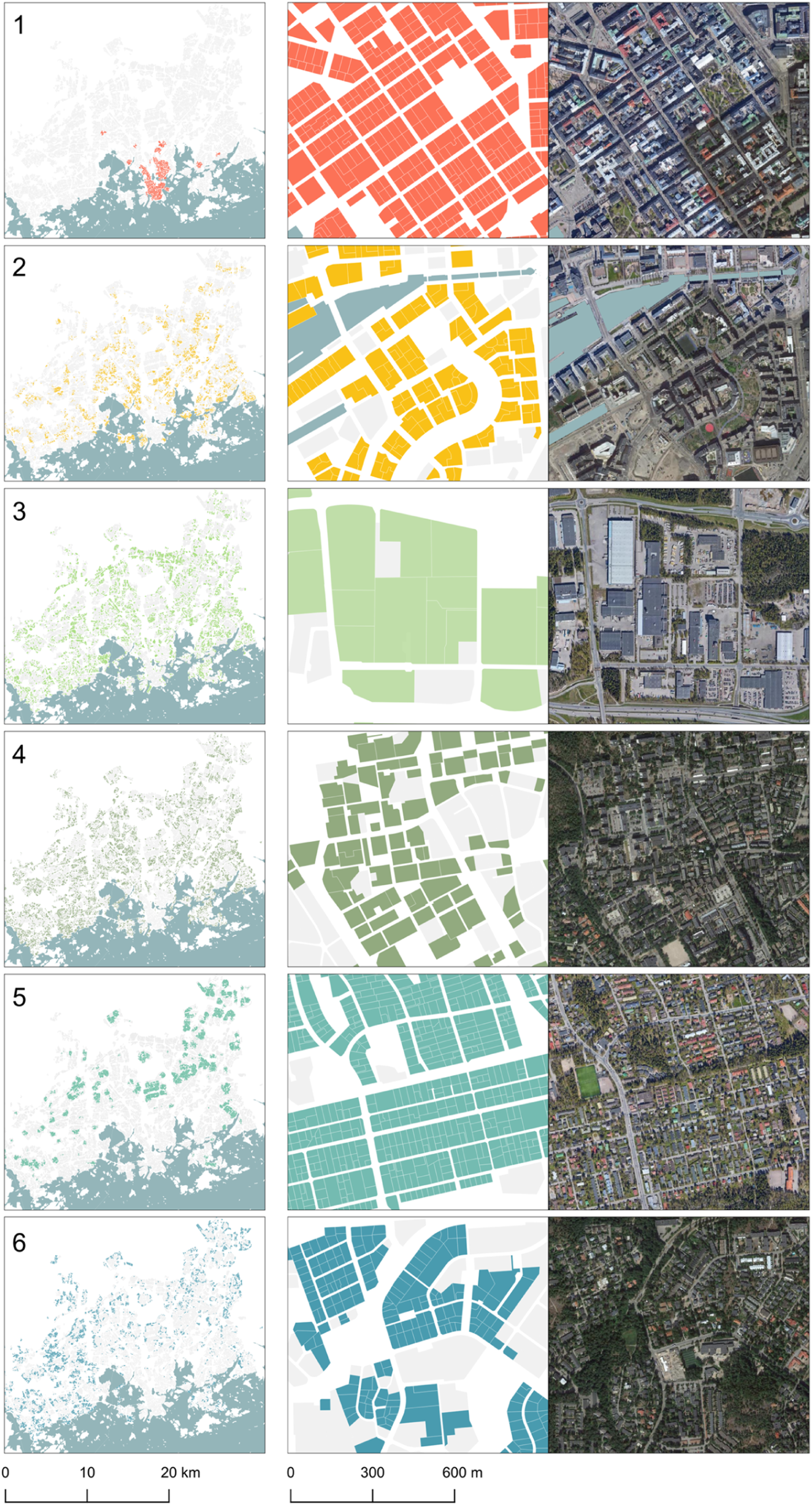
Plot type 1 consists of attached, high-density blocks with the highest integration and betweenness values on a neighbourhood scale, indicating excellent potential for local accessibility. This type is characterized by small plot sizes and a large number of plots within walking distance. Plot frontage ratios of type 1 have medium values. Public transport accessibility, the total number of people residing within 400 m and their income levels are the highest for this type. Type 1 forms the urban core with mixed-use development.
Plot type 2 is mainly located along streets with mid-range accessibility. Plots in type 2 have medium-built density and small plot sizes. They consist mostly of detached blocks. Plot frequency and plot frontage values show medium values. With the exception of significant differences in betweenness and integration values, type 2 and type 1 have similar values. The most accessible transportation infrastructure is the bus. The total number and income level of residents within 400 m of type 2 show medium values. The main land-use characteristics are residential and office areas.
Plot type 3 is characterized by the largest plot sizes and high frontage ratios, making it attractive for potential shopping malls and industrial facilities. The plot frequency for type 3 is the lowest. While the integration values of type 3 are in the low to medium range, the level of betweenness is low. The built intensity of type 3 is higher than type 2, but the level of public transport accessibility is lower. Moreover, demographic indicators show the lowest values for type 3. Industrial, commercial and institutional facilities are the main land uses.
Plot type 4 has similar morphological characteristics to type 3, with the exception of size. Plots in type 4 are smaller than those in type 3, although they are still the second largest among all plot types. Plots in type 4 mainly include groups of residential apartment blocks, department stores and office buildings. In terms of building density and demographic indicators, type 4 has low to medium values. The functional characteristics of this type consist of residential, commercial and office areas.
Plot type 5 is characterized by the smallest plot size and highest plot frequency. These plots have the lowest built intensity and plot frontage ratios. Accessibility-related indicators for type 5 have low values at the neighbourhood scale. While the number of residents within walking distance is low, the average household income for this type is quite high. In terms of public transportation accessibility, only bus stops are significant for plot type 5. This type mostly consists of residential areas with detached single-family houses located outside the city centre.
Plot type 6 has the lowest degree of accessibility in terms of angular integration, betweenness values and public transportation networks. In terms of plot frequency and plot frontage variables, values are medium. Type 6 has a low built intensity and a variety of building types, including single-family houses and detached apartment blocks. Demographic indicators for type 6 include a very low number of residents within 400 m, and low to medium average income levels. Residential areas constitute the main functional characteristics of this type.
The results illustrate the spatial distribution of systematically categorized character areas in the HMA. The spatial distribution of the six plot types shows that while some districts of the HMA include different types of plots, some of them have more homogeneous plot patterns (Figure 3). Distribution and concentration of the plot types shows that type 1 constitutes the prime retail area of the HMA with the highest degree of concentration. Type 2 is mostly distributed on the immediate periphery of the central area. Plot types 3 and 4 are generally adjacent or close to each other but have more dispersed spatial patterns. In the suburban area, type 5 has relatively high concentrations similar to those in type 2, forming clusters of neighbourhoods outside the city centre. Lastly, plot type 6 has the highest degree of spatial dispersion in the suburban area (see Figure S4 in Supplementary Materials). Spatial distribution of six plot types in the Helsinki Metropolitan Area.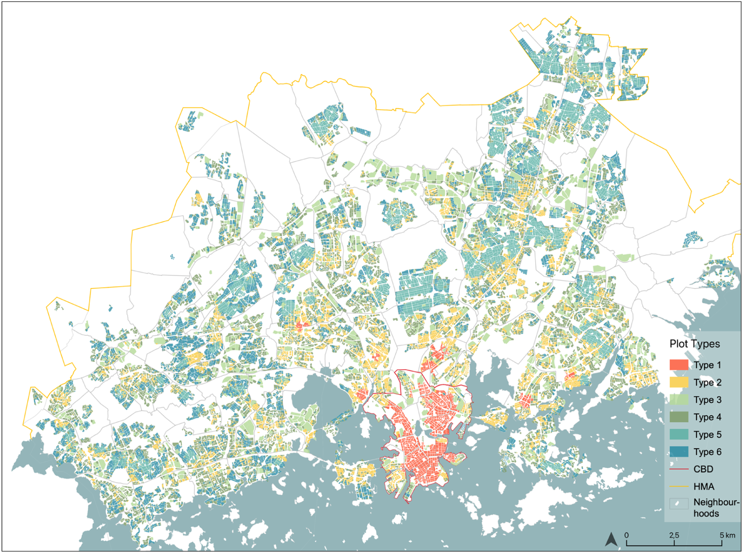
The relationship between plot types and spatiality of retail businesses
The six classified plot types were analysed in terms of retail distribution, agglomeration and diversity variables. To determine if there were statistically significant differences between them, the Kruskal-Wallis H Test was used. The test includes two hypotheses: (H0) the retail distribution, agglomeration and diversity of the plot types are the same; (H1) the plot types differ significantly in terms of retail distribution, agglomeration and diversity. The results showed that p < .05 for three variables, indicating a significant difference between plot types (see Table S3 in Supplementary Materials). Figure 4 presents the level of differences between plot types. Comparison of six plot types based on three dependent variables (Mean rank values were normalized between 0 and 1).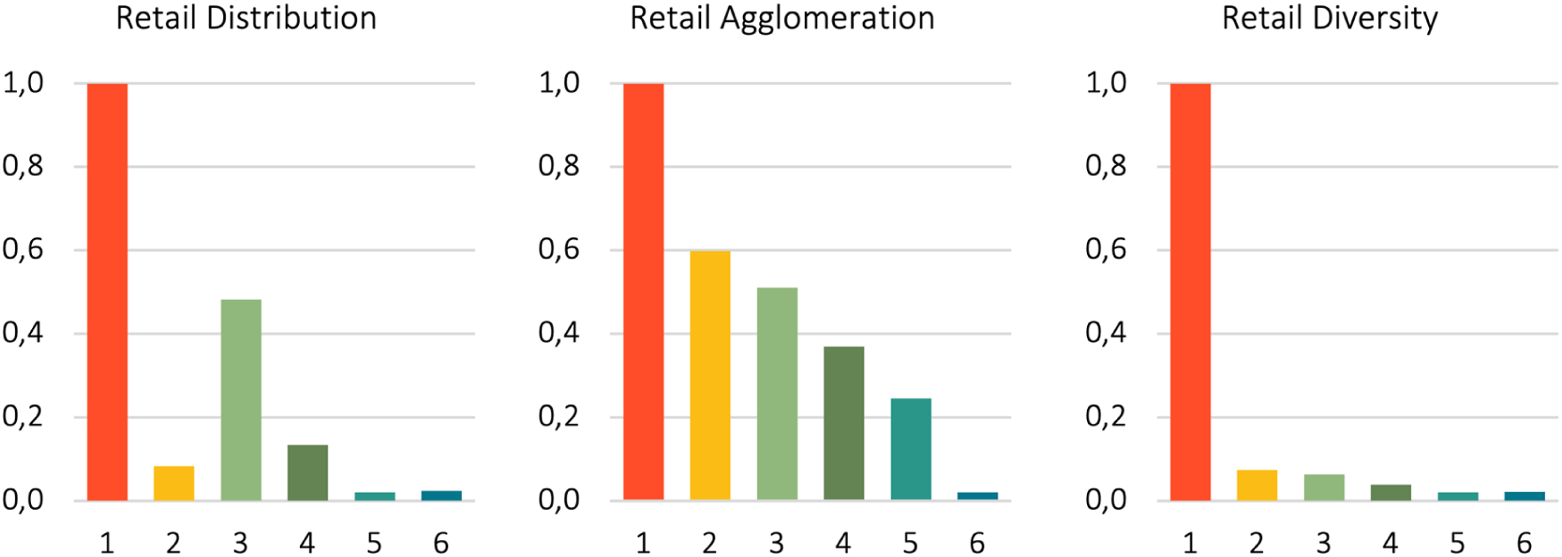
In terms of retail distribution, plot type 1 has the highest number among all plot types. On the other hand, the results show that the retail distribution of type 2 is less than types 3 and 4. Although type 2 has the closest morphological characteristics to type 1, plots with less accessible and bigger sizes like types 3 and 4 contain more retail businesses. On the other hand, plot types 5 and 6 offer a low spatial capacity for retail distribution compared to other plot types.
According to the distribution of seven retail types based on the NACE (2008) classification for each plot category, food and beverage service activities; and specialized stores such as clothing and medical goods are mostly located on centrally located fine-grained plots. Non-specialized stores such as supermarkets and department stores; and cultural and recreational goods are mainly located on larger grain plots which are relatively less accessible by foot on a neighbourhood scale (see Figure S5 in Supplementary Materials).
In terms of retail agglomeration, plot type 1, which is mainly located in the centre, has the most intense retail agglomeration. In contrast to retail distribution, plot type 2 has more retail agglomeration than types 3 and 4. Besides, type 5 has low to medium values, while plots in type 6 have the lowest level of retail agglomeration. The results show that most accessible, high dense and fine-grained plots with narrower frontages might accommodate retail clusters more readily (see Figure S6 in Supplementary Materials for spatial autocorrelation analysis). Furthermore, in terms of retail diversity, the graph shows that plot type 1 has the highest degree of diversity, while other plot types have very low levels. In addition to this significant difference, type 2 has the second highest diversity. However, the differences between the rest are not significant.
In the HMA, the reciprocal relationship among the functional and morphological characteristics of plots has generated different spatial conditions for retail development in different periods. As Figure 5 shows, after the 1950s an enormous amount of plot development occurred due to the vast migration to the HMA. The state tried to alleviate the housing shortage by handing over large areas to property developers for construction. As a result, the process of subdivision strategies of urban space has changed. Block and district-based development were promoted on the periphery, and the role of plots in placemaking policies particularly on retail development decreased. Spatial development stages of plots in HMA for each plot type and conceptualization of the relationship between plot and retail activity.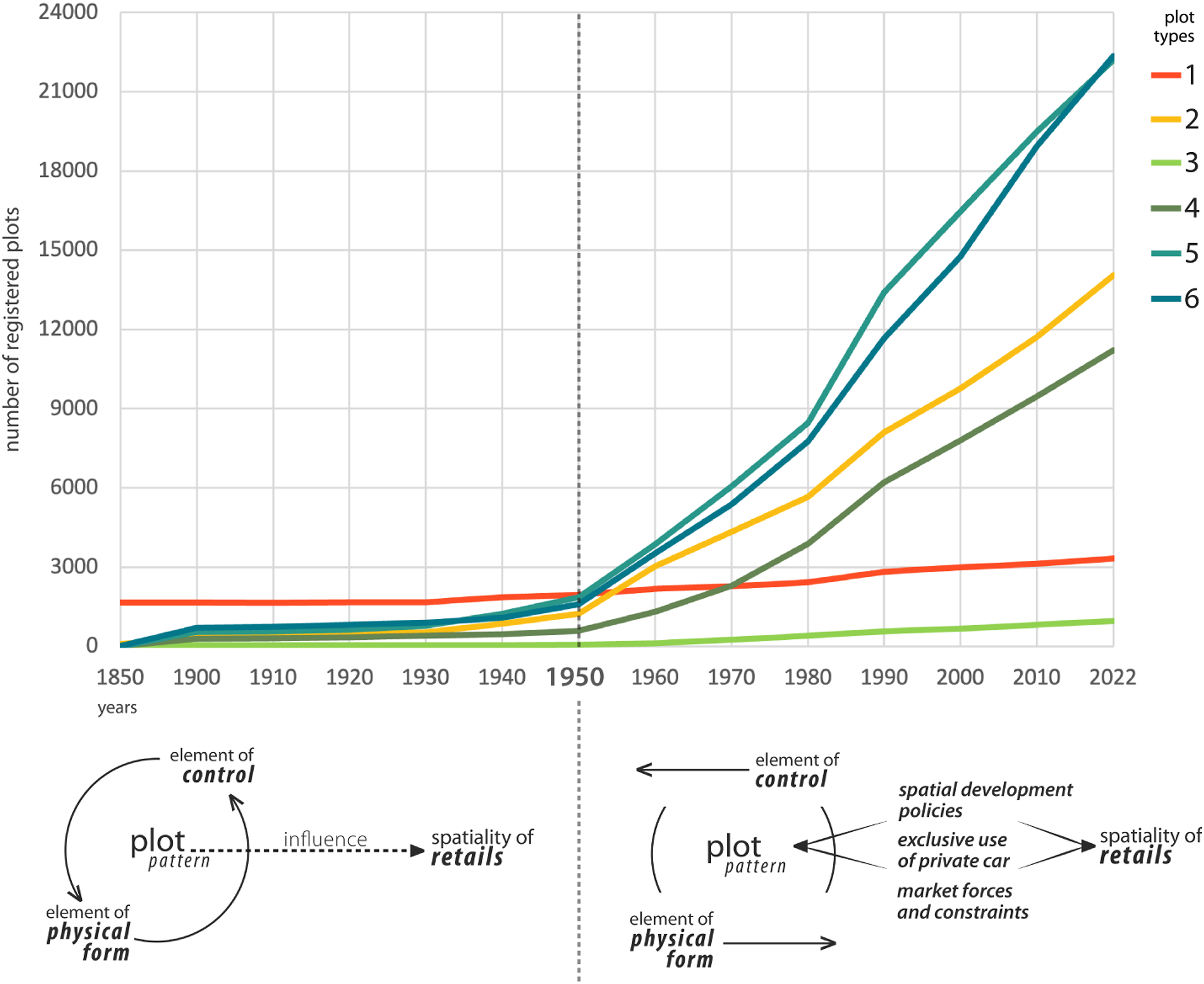
The plot as an element of form and control before the 1950s is a factor affecting the spatiality of retail units. After the 1950s, entrepreneurial spatial development policies, market dynamics, changing consumer preferences and exclusive use of private car brought a new approach to the spatiality of retailing and development of plot patterns. Plots were designed as the product of this new approach, and the dual nature of the plot that creates the potential circularity and connection between functional and morphological dimensions has been weakened. The trend in suburban areas towards large-scale spatial developments has evolved the retail geography towards highly coordinated, auto-oriented enclosed retail centres. As a result, the new approach to spatial development strategies has started to pose a threat to the presence of street-based retail units. Eventually, the exuberance of commercial streets in the suburbs disappeared with the emergence of big-box retailing.
Conclusion
This study identified six plot types in the HMA based on five morphological variables using unsupervised computational clustering analysis. The influence of different plot types on retail distribution, agglomeration and diversity were then examined. The computational plot characterization afforded a detailed understanding of the plot system in the HMA, which may not have been revealed through conventional cartographic surveys. Besides, the results showed that the plots are significant units of analysis to reveal the spatial capacity of urban form for retail activity. In this regard, following criteria based on the multiple nature of plots as an element of urban form and an element of control in urban space are elaborated for a resilient retail system.
In terms of urban form; the shape and location of plots are determined as the main components of spatial capacity for the sustainable retail system. They play a mutual role in determining the plot patterns and the spatial capacity of plots. The results reveal that the increased subdivision of land into plots with small sizes and low frontage ratios may create spatial conditions for street-based retail activity. Together with these, plots with high connectivity and betweenness centrality on a neighbourhood scale may promote the street as an ecosystem for retail activity. This ecosystem is shaped by dense plots with diverse and agglomerated retail units, where the habitus of different actors, such as property owners, shopkeepers and visitors play a role. Plots having these characteristics promote the longevity of independent retail stores in the streets and contribute to the vitality and viability of the space.
In this regard, plot type 1 affords these criteria and is capable of promoting street-based diverse and agglomerated retail stores. Type 2 has almost the same morphological characteristics as type 1 except for centrality measures. This comparison reveals that fine-grained plots with low frontage ratios provide high retail agglomeration, while lower centrality values have a negative effect on retail diversity and distribution for fine-grained plots. A certain degree of retail agglomeration in plot type 2 creates a potential for the creation of retail streets. On the other hand, low-density fine-grained plots with the lowest degree of accessibility (i.e. types 5 and 6) fail to meet the criteria to encourage retail development along the streets, creating individual and very small numbers of disconnected commercial units.
In addition, larger-grain plots with wider frontages and low level of centrality (i.e. types 3 and 4) accommodate a higher level of retail distribution, but with a low tendency for retail agglomeration and diversity around them. While such plots have the potential to accommodate a large number of retail units on an individual basis, they tend to result in less retail agglomeration and diversity in the surrounding plots on a neighbourhood scale. This is because the large-grain plots generate discontinuous space consisting of closed, isolated, and less integrated built forms such as big-boxes. The built environment formed by such plots often defines the streets only as a space for movement rather than a space for occupation and retail activity.
The retail landscape of the suburban area is largely dominated by such plots which emerge from a low level of land subdivision (i.e. types 3 and 4) and the production of standardized residential typologies (i.e. types 5 and 6). Such spatial development may undermine the role of plots as a physical form in placemaking practices. Therefore, these spatial development practices generate fragile ecologies for the retail landscape, potentially leading to the decline of streets as active containers of retail activity.
In terms of being an element of control; diversity of actors and uses, and the operation and management of space are determined to be the main components of spatial capacity of plots for a sustainable retail system. The results show that the increased number of plots in an area enables different user strategies in terms of economic, social and physical development. Even the increased built density in an individual plot may generate the same opportunities. Diversity of actors in the systems increases the adaptive capacity of the retail landscape against various disturbances. This condition also encourages consumer diversity and retailer variety. In addition, this study reveals that large-grained plots potentially lead to the generation of co-ordinated spaces such as gated residential areas and shopping malls. Such trends in cities towards large-scale spatial developments have a negative effect on the presence of street-based independent retail businesses. Therefore, it is suggested that plots having more porous and interconnected built layout may create a favourable urban space to accommodate independent retail units without a coordinated management structure between retailers.
In this regard, mixed-use development in plot type 1 affords diversity of actors without a co-ordinated management structure. Each retail businesses, independently competing or complementing others in the streets, forms the retail landscape. Throughout this process, the retail landscape emerges not only due to the functional qualities of space but also to the reciprocal relationship between the elements of urban form and uses. On the other hand, the spatial capacities of plot types 2, 5 and 6 are not sufficient to accommodate diverse actors as they are mostly composed of homogenous land-uses. On the contrary, large-grained plots (i.e. types 3 and 4), where shopping malls and department stores exist in a coordinated manner, may accommodate different actors together on a single plot but they do not allow for the emergence of a retail landscape around them.
Within this context, it is argued that plots having the spatial capacity to promote street-based commerce are formed by spatially integrated, fine-grained urban fabric with independent micro-businesses involving a diversity of functions and actors. Such an approach promotes the resilience of the retail system, resulting from the interplay between the roles of the plot as an element of physical form and an element of control, and encourages sustainable urban development. Understanding the spatial capacity of the plots enables planners and policymakers to make more effective use of the regulatory power of plots for building fabric and street layout, which moreover serves as an institutional tool for defining land uses. Approaching the relationship between urban form and retail activities from this perspective, with an integrated planning approach, will sustain and encourage the vitality of commercial streets not only in the city centre but also in the suburban area.
Finally, there are several limitations in this research. Firstly, this study does not aim to establish causation between the variables, but rather focuses on the statistically significant relationships. Secondly, while the economic structure of the city consists of a range of sectors, this research focuses on retail businesses that play an active role in daily life at the neighbourhood level. Thirdly, the analysis does not consider the influence of land use regulations or market competition on the retail distribution. Instead, it considers the physical characteristics of the plots as input. Finally, there may be sub-character areas within the determined morphological regions. Future research could examine possible lower-order areas by including micro-scale factors to provide further insight.
Supplemental Material
Supplemental Material - Exploring the plot patterns of the retail landscape: The case of the Helsinki Metropolitan area
Supplemental Material for Exploring the plot patterns of the retail landscape: The case of the Helsinki Metropolitan area by Hulusi Eren Efeoglu, Anssi Joutsiniemi and Skirmante Mozuriunaite in Environment and Planning B: Urban Analytics and City Science.
Footnotes
Acknowledgements
We thank Dr. Olgu Çalışkan and the anonymous reviewers for their valuable comments and suggestions.
Declaration of conflicting interests
The author(s) declared no potential conflicts of interest with respect to the research, authorship, and/or publication of this article.
Funding
The author(s) disclosed receipt of the following financial support for the research, authorship, and/or publication of this article: This work was supported by the Finnish National Agency for Education.
Data availability statement
The datasets generated and analyzed during the current study are available from the corresponding author on reasonable request.
Supplemental Material
Supplemental material for this article is available online.
Notes
References
Supplementary Material
Please find the following supplemental material available below.
For Open Access articles published under a Creative Commons License, all supplemental material carries the same license as the article it is associated with.
For non-Open Access articles published, all supplemental material carries a non-exclusive license, and permission requests for re-use of supplemental material or any part of supplemental material shall be sent directly to the copyright owner as specified in the copyright notice associated with the article.