
Abstract
To achieve urban resilience, assessment of the bioclimatic impact of various planning solutions should be given high priority in the decision-making process for the implementation of urban planning interventions. To aid in this process and improve the creation of resilient open spaces, the Bioclimatic Index has been developed as an evaluation tool and simple guide for local stakeholders. The assessment of the indicator is essential to determine the likelihood of its use in other Mediterranean cities as the methodological framework was based on the microclimate simulation results of the case study area of Patras Old Port, which is a seaside open space with a Mediterranean climate. In this framework, the Bioclimatic Index is used to rate the regenerated open spaces in Thessaloniki, Malaga, and Genoa, three Mediterranean seaside areas. The indicator values are compared to the microclimate simulation results created based on their planning solutions, aiming to test the accuracy, transferability and scalability of the indicator. The research result showed that the seaside space of Malaga, which has been evaluated as the optimal regeneration plan based on the Bioclimatic Index, creates the most favorable microclimate conditions through seasons, supporting the use of the indicator for evaluating the bioclimatic impact of regeneration plans in Mediterranean cities.
Introduction
The concept of open public space has been the subject of study among multiple disciplines, such as economics, sociology, politics, and spatial planning. These fields approach open public spaces in different ways but can work in a complementary manner to provide a better understanding of this complex concept (Osmidopoulou, 2019). Approaching the term “open public space,” beyond the geographical delimitation, is characterized as a dynamic variable identified by socio-economic, political, environmental, cultural, and other factors, considered as a common set of elements, ideas, and views (Babiniotis, 2012).
Considering that open public spaces play a crucial role in shaping cities and composing the urban fabric by giving life and diversity to cities, the continuous urban development that takes place at a socio-economic and ecological level, such as urban population growth, climate change, and digital transformation, poses urban risks resulting in the conversion of cities to vulnerable and unstable socio-economic systems. In this context, the public urban area in relation to the risks and disturbances that cities are confronting, should play a decisive role with positive responses for achieving urban resilience (European Commission, 2008; IPCC, 2012; European Commission, 2019; ΙPCC, 2021).
The way in which urban spaces are shaped and the implementation of urban interventions/regeneration plans that contribute to urban resilience are crucial for the future of cities, as the appropriate design of the public spaces operate advantageously for the development of private space and the whole urban fabric (Özel, 2014). In this framework, to support the evaluation process of urban plans for implementing solutions that result in a citizen-friendly microclimate and enhance city resilience, the Βioclimatic Index has been developed for comparatively rating urban plans based on their environmental impact (Chondrogianni and Stephanedes, 2022).
The current research focuses on assessing the Bioclimatic Index regarding the use and application of the proposed methodological framework in multiple locations to test its transferability and scalability. Specifically, the accuracy of the indicator and the urban method rating is analyzed in different open spaces of multiple Mediterranean seaside urban areas to identify the effectiveness of the proposed model in these locations.
Theoretical background
Towards urban resilience through bioclimatic urban planning
The pursuit and effort to guide cities in achieving urban resilience range from the local to the global level, including international and local, public or private bodies that help to implement global actions that aim to guarantee the future of cities. While the majority of actions are taken by city networks, international organizations and non-governmental organizations, the academic community and private sector enterprises (UNISDR, 2012), the 100 Resilient Cities program, from the Arup Architectural Design Company, in cooperation with the Rockefeller Foundation, is among the initiatives that stand out. Aiming to achieve urban resilience to natural, social, and economic challenges, the creation of a global city network for the “exchange of experience and know-how to address the current urban challenges” is one of the priorities of the initiative through the development of a common City Resilient Framework (CRF) (Resilient Cities Network, 2013).
In addition, the development of an evaluation tool for assessing and guiding short-term, medium, and long-term interventions has been a priority for the United Nations Office for Disaster Risk Reduction of the UN-Habitat organization, aiming to promote sustainable development of human settlements and enhance urban resilience to the impact of natural and man-made crises through bioclimatic urban planning (Weichselgartner and Kelman, 2014). At the same time, UN-Habitat (2015) has developed the City Resilience Profiling Program (CRPP), which supports local governments to improve resilience through the development of integrated urban policies, strategic approaches and measurement tools prioritizing bioclimatic urban planning to guarantee the durability of cities. Implemented through multiple collaborations and extended networks worldwide, the CRPP raises awareness of the urban challenges and risks as well as on the best practices of urban planning strengthening resilience (Osmidopoulou, 2019).
In this framework, supporting interventions that address this issue though promoting bioclimatic design is crucial as the urban microclimate created in open spaces directly affects traffic and city resilience to climate change and urban risk (Chondrogianni, 2021). For this reason, there is a growing body of research for the estimation of comfort conditions (e.g., local wind speed, air temperature and radiation) for users of outdoor spaces (Nikolopoulou and Lykoudis, 2006; Stathopoulos et al., 2004; Walton et al., 2007; Willemsen and Wisse, 2007).
This research aims to assess the use of the Bioclimatic Index, which is an evaluation tool that can be used to comparatively evaluate urban planning methods based on their bioclimatic impact in cities. As the set of relevant parameters, that is, the thermal and wind speed conditions, is wide across multiple types of open spaces and locations, the current study focuses on identifying the effectiveness and reliability of the Bioclimatic Index in specified open urban spaces that are situated next to the sea, particularly in a Mediterranean climate, which is a combination of high relevance in Europe.
The urban microclimate of the open spaces
Considering that the urban microclimate consists of a crucial factor for urban resilience, multiple thermal indicators have been developed that aim to identify those conditions that offer thermal comfort. The models of thermal indicators for outdoor spaces found in the literature can be described as empirical or analytical. Empirical models are based on specific surveys and measurement data and can be applied only to similar conditions and should not be generalized globally. Analytic models were created based on a human thermal balance and aimed at the validity of their results in any circumstances. Among the thermal indicators, the indicators of PMV, PET, PT, and OUT-SET * are widely used (Fanger, 1982; Monteiro and Alucci, 2008).
Added to the thermal indicators, the ASV thermal sensation voting index can be used as an evaluation tool for the microclimate of specific urban areas. The ASV index is calculated based on models developed in various European cities (Athens, Thessaloniki, Milan, Freiburg, Kassel, Cambridge, and Sheffield) through user responses to evaluate a 5-point-to-scale of convenience (from a feeling of very cold feel to very warm) in open urban spaces in conjunction with meteorological data in each city (Nikolopulou et al., 2004).
Focusing on the tight connection between urban planning and the microclimate created in open spaces, the Bioclimatic Index was developed in previous research as an evaluation tool to support the decision-making process in implementing urban and regeneration plans addressing extreme weather conditions, such as heat waves and urban heat islands, and enhancing urban resilience. In the development process, multiple bioclimatic planning methods for open spaces were studied and rated based on their contribution in creating favorable climate conditions and resilient urban areas. As the Patras seaside space was selected as the case study area for the development of the indicator, it was decided to assess extended applicability of this tool (Chondrogianni and Stephanedes, 2022).
The main objective of the comparative assessment of the Bioclimatic Index for resilient open spaces is to examine the possibility of implementing the Bioclimatic Index methodology and tool in multiple locations and to evaluate the transferability and replicability of the indicator. Therefore, the current research investigates the accuracy of the evaluation and rating of the urban planning methods that have been analyzed in previous research.
Evaluating urban planning proposals through the Bioclimatic Index
Bioclimatic urban planning seeks to identify the crucial parameters to be considered at the planning stage so that urban interventions can serve activities that favor social interaction and urban resilience. Design guidelines for bioclimatic urban planning can be classified in three key categories:
Thermal comfort is critical in affecting the quality of life, and its definition is a key issue in the literature. The comfort limits for temperature (Effective Temperature, ET) range between 19 and 24.5°C (ASHRAE 1997; Auliciems and Szokolay, 1997; Chatzidimitriou, 2012; Fanger, 1982; Hoppe, 2002; Mayer, 1993; Spagnolo and deDear, 2003; Chatzidimitriou, 2012). In addition, it is estimated that the wind becomes an annoyance when its speed exceeds 5 m/s, and unpleasant at values exceeding 10 m/s (Yannas, 2002). Pedestrians are considered at risk at average wind speeds greater than 15 m/s (Reiter, 2010). Under 2.5 m/s, the lack of wind is unpleasant, especially on hotter days (Chondrogianni, 2021).
The Bioclimatic Index has been developed considering the complex procedure of the decision-making process for selecting urban regeneration plans with positive environmental results. The Bioclimatic Index supports this process by prioritizing the long-term environmental results of urban planning interventions and by offering a unified tool for comparative evaluation of the effects of outdoor urban design in terms of impact on the urban microclimate. Τo address this need, the Βioclimatic Index has been proposed as an evaluation tool, taking into consideration the comparative rating of multiple urban planning methods. Their rating has been estimated by simulating planning scenarios within a range of bioclimatic guidelines and methods that aim to provide a favorable microclimate and to enhance urban resilience.
The Bioclimatic Index is defined as the sum of the ratings of a planning method multiplied by the times that method is involved in the evaluated masterplan. The calculation of the Bioclimatic Index V is given by relation (1)
where
The development of alternative regeneration scenarios incorporating the desired set of methods and guidelines of bioclimatic urban design focuses on open urban spaces. The open space of Patras Old Port in Greece has been selected as a case study. The developed regeneration scenarios aim to incorporate the urban planning methods and guidelines, identified through a literature review, for achieving thermal and air comfort conditions in open spaces (Chondrogianni, 2021).
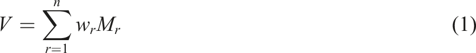
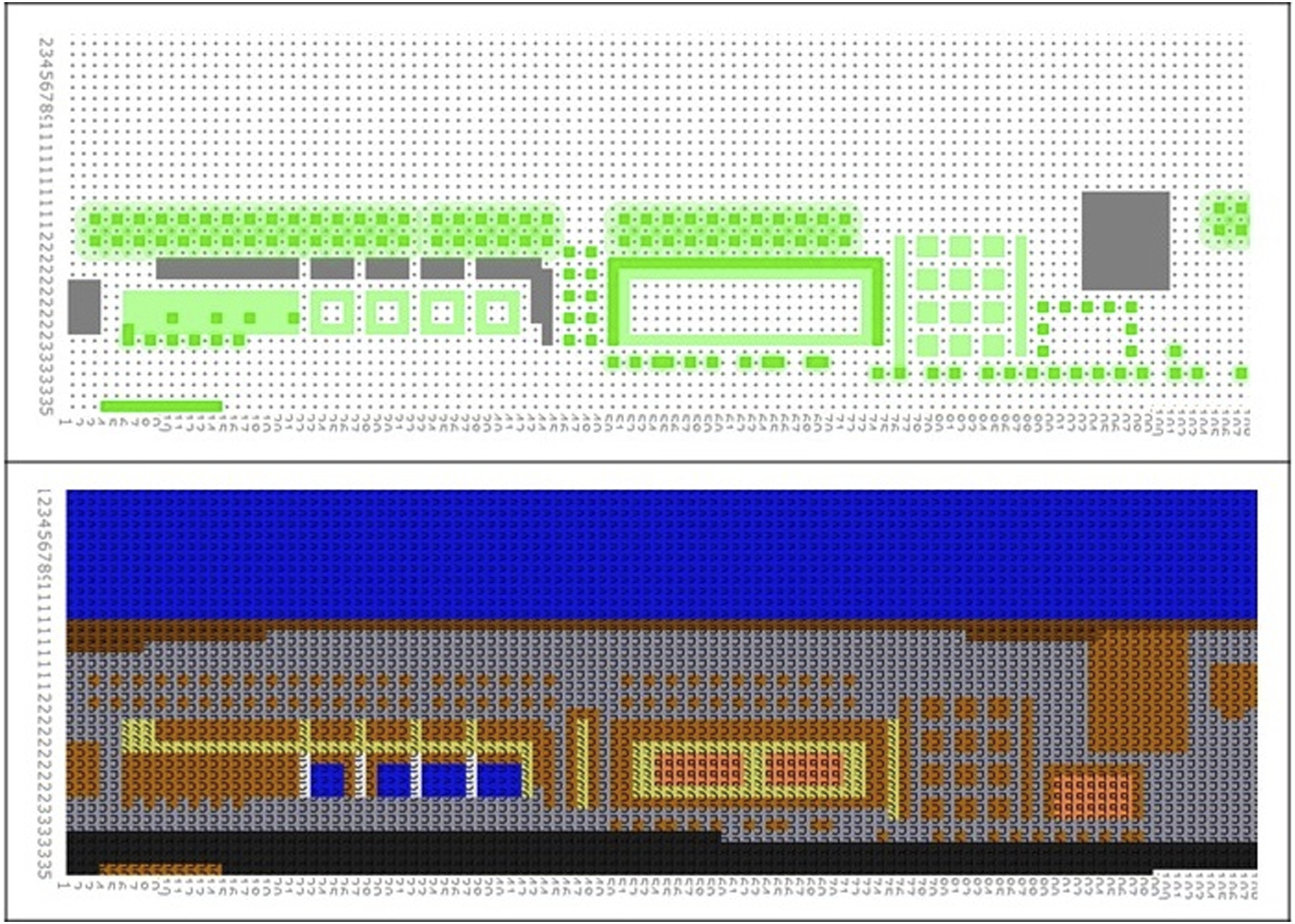
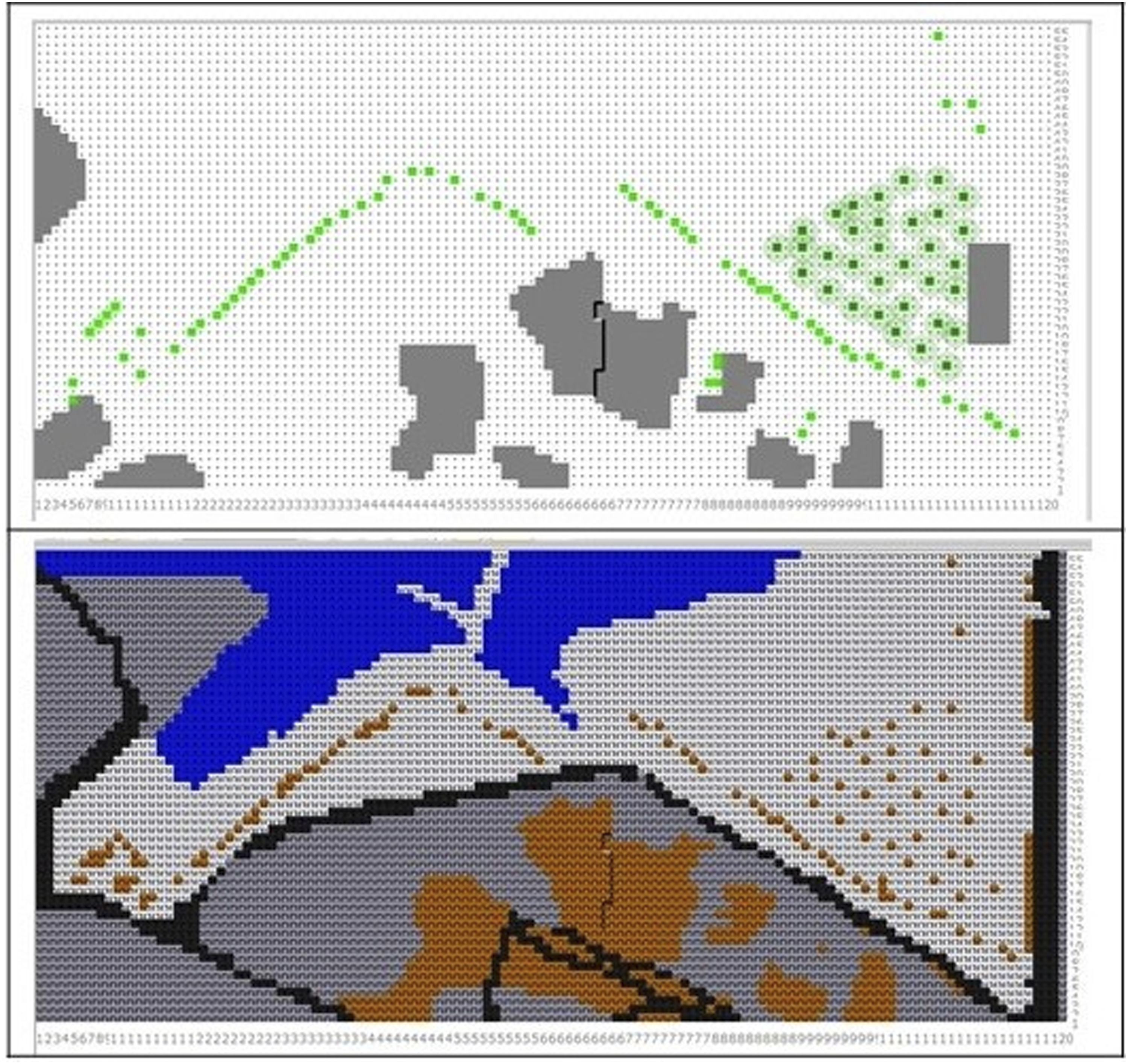
In the first scenario, small interventions, from the categories of geometric structure and vegetation, were selected based on the current situation and the existing materials. The masterplan (Figure 1) indicates the interventions, for example, Tree canopy with big trees (M1) and Green Fences with medium vegetation (M2) or larger trees (M4) for wind protection. Masterplan of Scenario 1.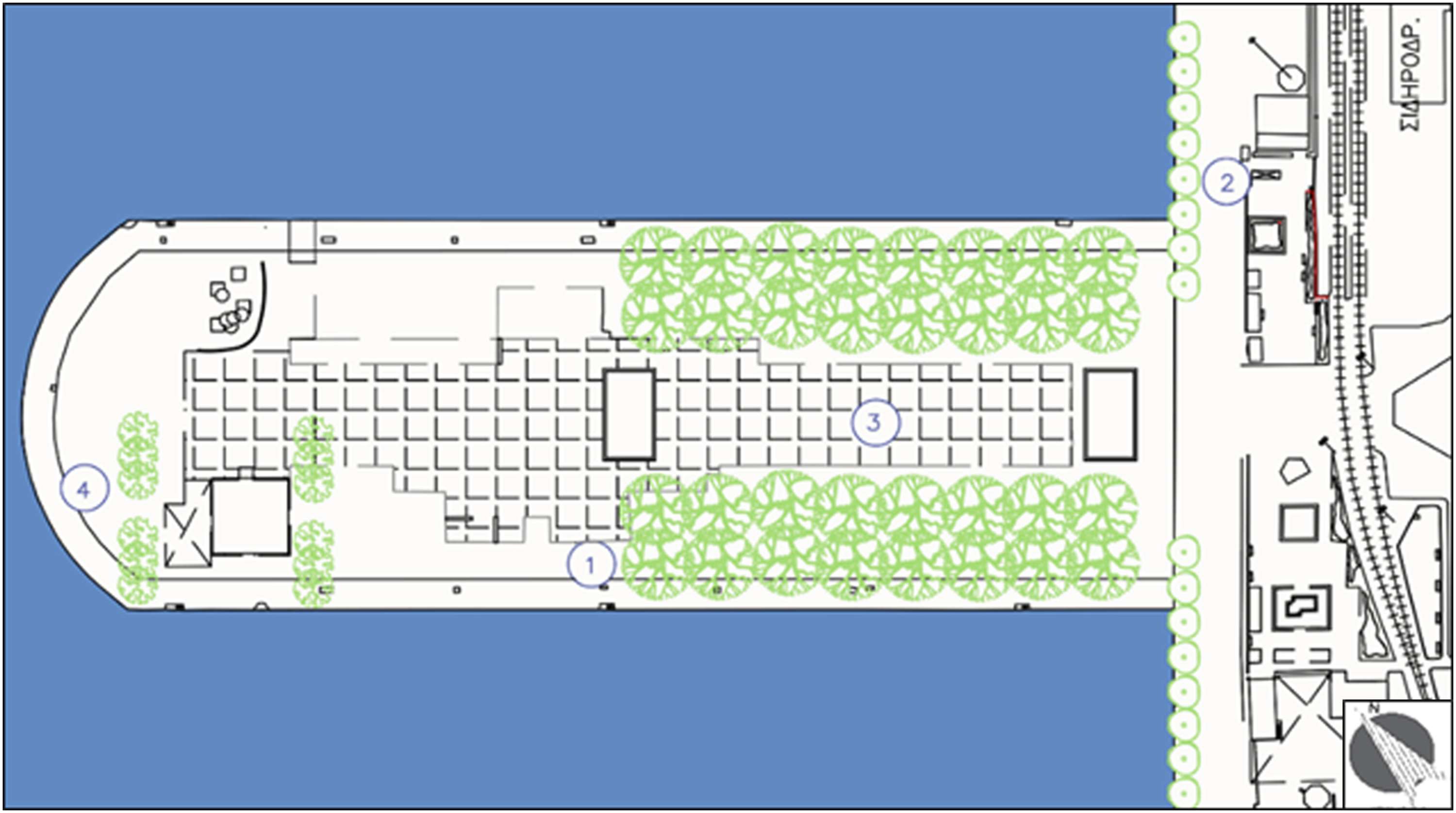
In Scenario 2, the vegetation and geometric structures of the open space remain the same, and the intervention focuses on the construction and coating materials, as in the masterplan, Figure 2. The selected material contributes to creating more favorable microclimate conditions, and mitigating climate change phenomena, such as the urban heat island. For example, M5 indicates the use of medium vegetation combined with brick/cobblestone pavement while M10 refers to the use of white concrete as pavement. Masterplan of Scenario 2.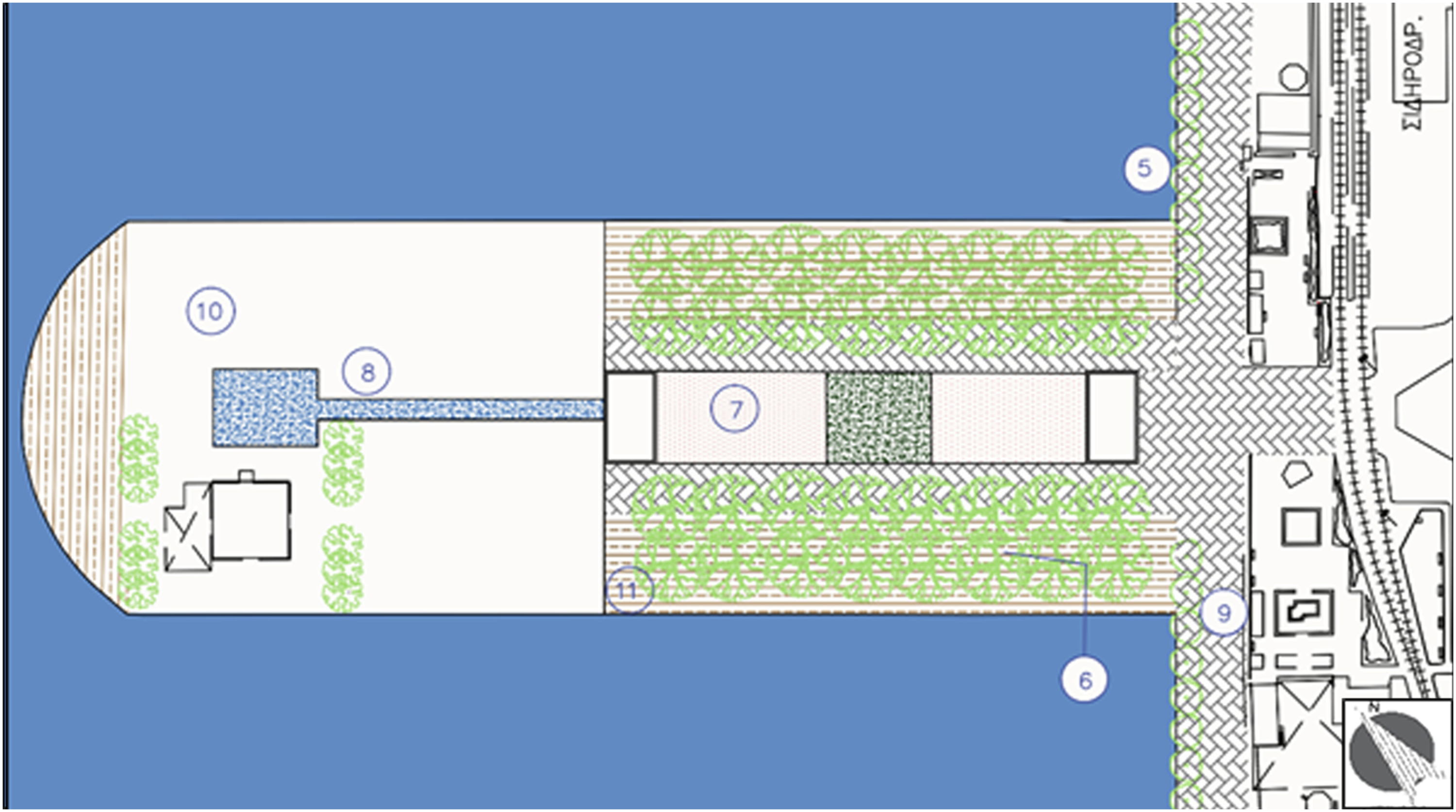
In Scenario 3, interventions combining methods from the three categories are created to study the microclimate in more complex planning solutions. For example, the masterplan (Figure 3) illustrates the use of medium palm trees over wooden pavement (M13), the creation of a Public Passage between buildings with a green roof, and a pavilion with facades (M17) or the design of a Closed Plateau (M18) combining the use of geometric structures, vegetation, and materials (brick/cobblestone) for wind protection and thermal comfort. Masterplan of Scenario 3.
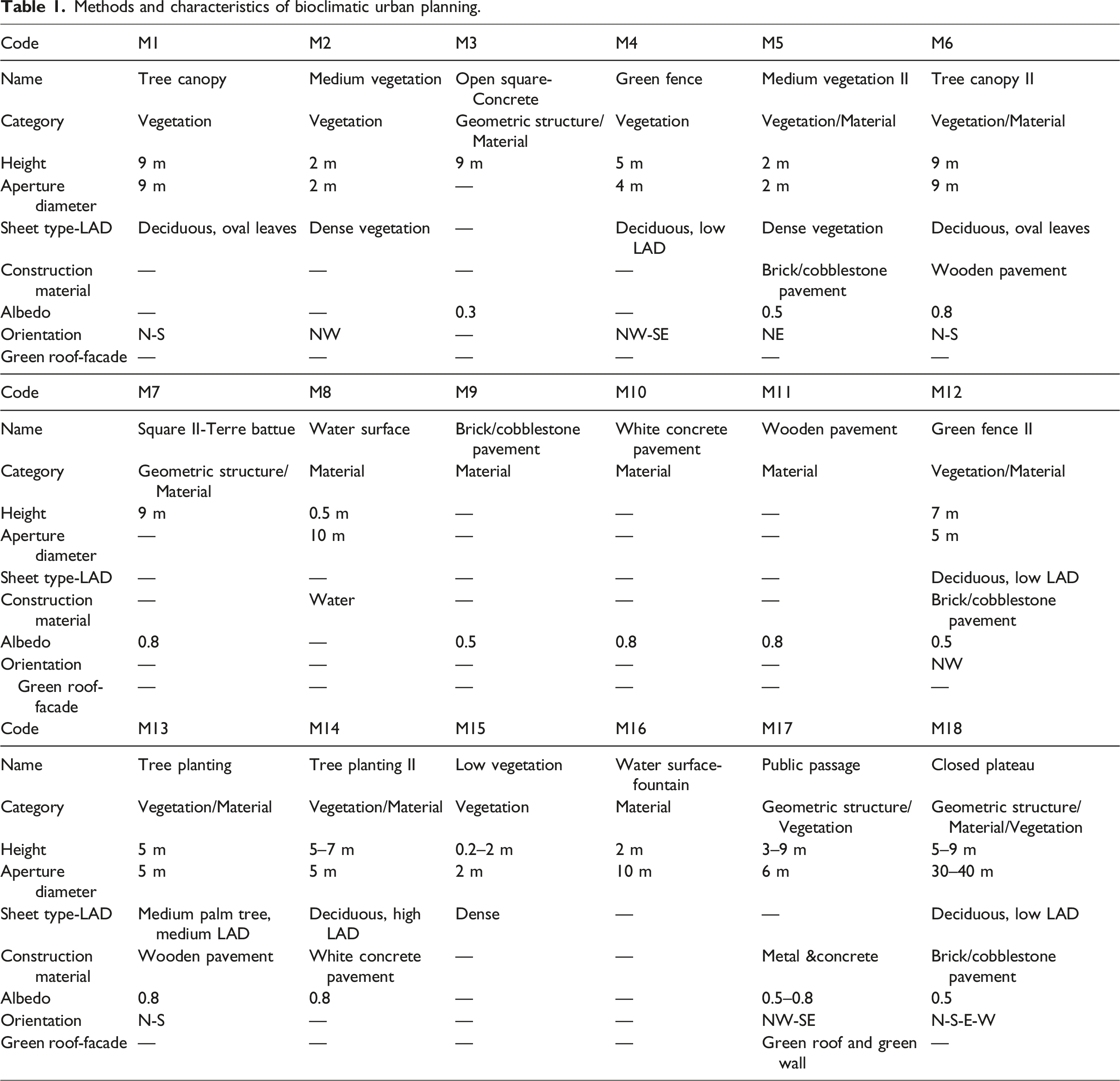
Methods and characteristics of bioclimatic urban planning.
As the microclimate conditions created by urban planning methods in open spaces can differ over the seasons, an ENVI-met microclimate simulation for evaluating the three basic regeneration scenarios of the case study area have been done across seasons. More specifically, one day of extreme weather conditions in winter and one in summer were simulated, as well as 24 h of medium prevailing conditions in spring and in autumn. The duration of each microclimate simulation was 24 h, and the time interval of each simulation was 1 h.
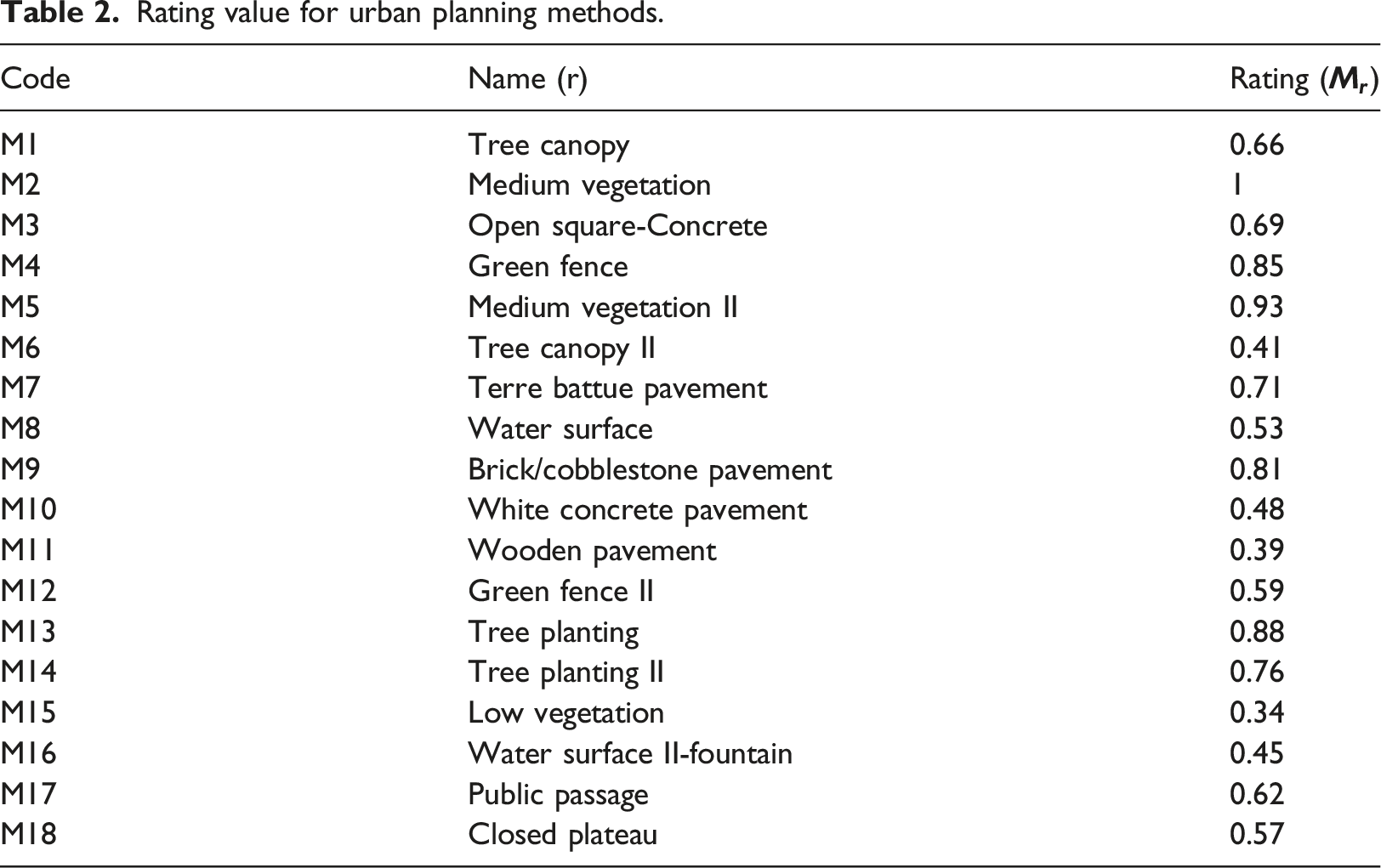
Rating value for urban planning methods.
The estimated rating is proposed for use by stakeholders to evaluate the Bioclimatic Index of urban plans prior to implementing design solutions of positive impact to city resilience. The Bioclimatic Index can work as a simple guide to support the evaluation of urban masterplans based on microclimate parameters. In this context, the transferability of the Bioclimatic Index in multiple locations and different scales is under study in the current research.
Assesment analysis of the Bioclimatic Index
To serve the research objective, the urban spaces of European Transport Hubs that present common characteristics with the Patras’ case study area, which was selected for the development of the Bioclimatic Index, are analyzed in the assessment process. In particular, the cities of Thessaloniki (Greece), Genoa (Italy), and Malaga (Spain) are selected as Mediterranean maritime and port cities that need to address current urban challenges, for example, climate change, heat waves, and urban heat islands. They are medium-sized cities with urban seafront spaces, such as old ports or coastal jetties, which have been redesigned and regenerated to provide open public spaces that upgrade citizens’ quality of life.
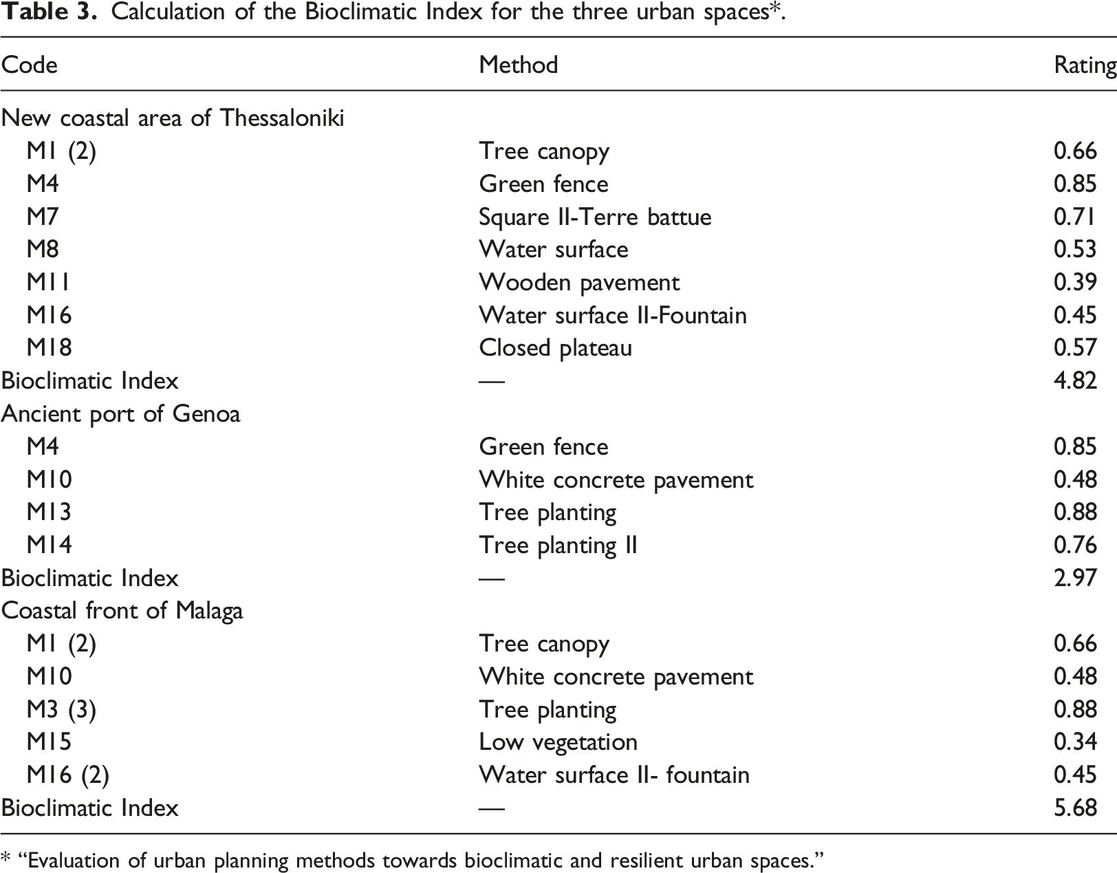
In the assessment process, the following methodological steps were followed in order to evaluate comparatively the implementation of the Bioclimatic Index: 1. Defining the study area (the urban open space) and collecting the data sources for the regeneration (e.g., maps, drawings, photos) implemented for each of the urban areas. 2. Rating and calculating of the Bioclimatic Index of each regeneration plan (Table 3) based on the incorporated planning interventions (as described through maps, drawings, photos) and the proposed methodology (Tables 1 and 2 and Relation 1). 3. Creating the simulation models of the urban spaces in the ENVI-Met software (Figures 4–6). 4. Running microclimate simulations for the studied areas and exporting results for the air temperature and wind speed conditions (Tables 5–7). 5. Comparing the results of microclimate conditions in the different area with the values of the Bioclimatic Index in the same spaces (Tables 3–7). 6. Concluding on the transferability of the Bioclimatic Index and identifying weaknesses and restrictions. Calculation of the Bioclimatic Index for the three urban spaces*. * “Evaluation of urban planning methods towards bioclimatic and resilient urban spaces.” ENVI-met model for the New Costal area of Thessaloniki. ENVI-met model for the Ancient Port of Genoa. ENVI-met model for the Coastal Front of Malaga.
The three regenerated urban spaces and their design principles are described in the following chapters.
New costal area of Thessaloniki
The key axis of the regeneration plan was the search for a new balance between the city and the sea. In particular, the New Costal Area of Thessaloniki is a linear place with limited depth but a long length, which accurately gives the characteristics of a “front,” stretching over the difficult and provocative threshold between land and sea as well as between natural and constructed landscape. The urban design at this limit must coexist and be coherent with the aquatic elements, which reflect the most unstable form of nature (Nikiforidis and Cuomo, 2009).
The New Coastal Space covers an area of 21,600 sqm while the implemented urban interventions have, as a key element, the creation of an outdoor hospitable space for citizens in which the natural element dominates. For this reason, this transitional zone of the city consists of small gardens (e.g., Water Garden, Seasons Garden, Sound Garden) that are integrated into the linearity of the overall design.
Ancient port of Genoa
The area of the Ancient Port (Porto Antico) of Genoa has been shaped in a coastal area that hosts, primarily, marina functions, and cultural events. For this reason, the public space on the “waterfront” of the modern city is the heart of the city, the soul of the historic center and one of the largest squares of the Mediterranean. The Ancient Port is the open public space where tourism, culture, exhibitions, sports, and citizen functions meet daily (Porto Antico di Genova Spa, 1992).
The urban regeneration program that was implemented—mainly at the port—both in 1992, due to EXPO1992 and in 2004 with the Genoa Cultural Capital of Europe, remodeled the ancient port to a complete entertainment pole, including the “Biosphere” landmark—a gigantic glass sphere that hosts a mini-tropical ecosystem—an open seawater swimming pool and the “Asteroid Lift Bigo,” where tourists and citizens can enjoy an unobstructed 360° degrees view over the city.
Coastal front of Malaga
The coastal front of Malaga, which is inserted between the two basic docks of the city’s harbor, is a linear array of an outdoor urban space of 24,000 sqm. The regeneration of the area, completed in 2011, follows the design of the first prize gained in an international competition of ideas, signed by architects Jerónimo Junquera and Liliana Obal. It consists of a pedestrian area under a linear layout of palm trees and a pergola that extends alongside the pier. As part of Palm Grove scenarios, three buildings that allow maximum visual permeability from the city are also created. One of these is a marine station for luxury cruise ships, and the other two are for educational and cultural use.
The main design objective was that the urban space will accommodate social events, permanent or temporary, and will become the public reference area that the city needs. The area functions as a linear “living room” overlooking the Mediterranean, with key elements such as green areas and the pergola running alongside the dock. As the walk is continuing straight under the shadow of the pergola, there is a wide range of surprises with outdoor spaces and facilities for visitors. Buildings that interplay within the green park, placed vertically on the open-air ground floor, feature translucent glass, looking for maximum visual pedestrian permeability from the city at sea and the park (Archdaily, 2004).
Calculation of the Bioclimatic Index
Based on the regeneration plans of the studied urban spaces, the urban planning methods that are incorporated to support bioclimatic design are identified in the plans. Through the methodological framework for estimating the Bioclimatic Index of regeneration actions/plans for urban spaces (Chondrogianni and Stephanedes, 2022), the value of the Bioclimatic Index for the studied urban spaces is calculated and presented in detail in Table 3.
The calculated values of the Bioclimatic Index show that the Coastal Front of Malaga receives the highest rating regarding the contribution to urban resilience, followed by the New Coastal Area of Thessaloniki. Finally, the Ancient Port of Genoa receives the lowest rating among the studied urban spaces, indicating that it is the least effective plan regarding bioclimatic design.
Microclimate simulations of the urban regeneration plans
For the three urban spaces in which regeneration actions have been carried out, the ENVI-MET microclimate simulation software has been used to create their space models and to run alternative microclimate simulations of various weather conditions. The microclimate simulations have been performed to compare the design effect and impact in the weather conditions created in the urban spaces with the values of the Bioclimatic Index.
Microclimate conditions created by urban planning methods in open spaces can differ over the seasons. In this research, this issue was addressed by using simulations for evaluating the three regenerated urban spaces by ENVI-met across the seasons. More specifically, the microclimate simulations carried out involved three cases of different conditions, one day of extreme weather conditions in winter and one in summer as well as a day with medium prevailing conditions of spring and autumn. The duration of each microclimate simulation was 12 h (10 a.m. to 10 p.m.), and the time interval of each simulation was 1 h.
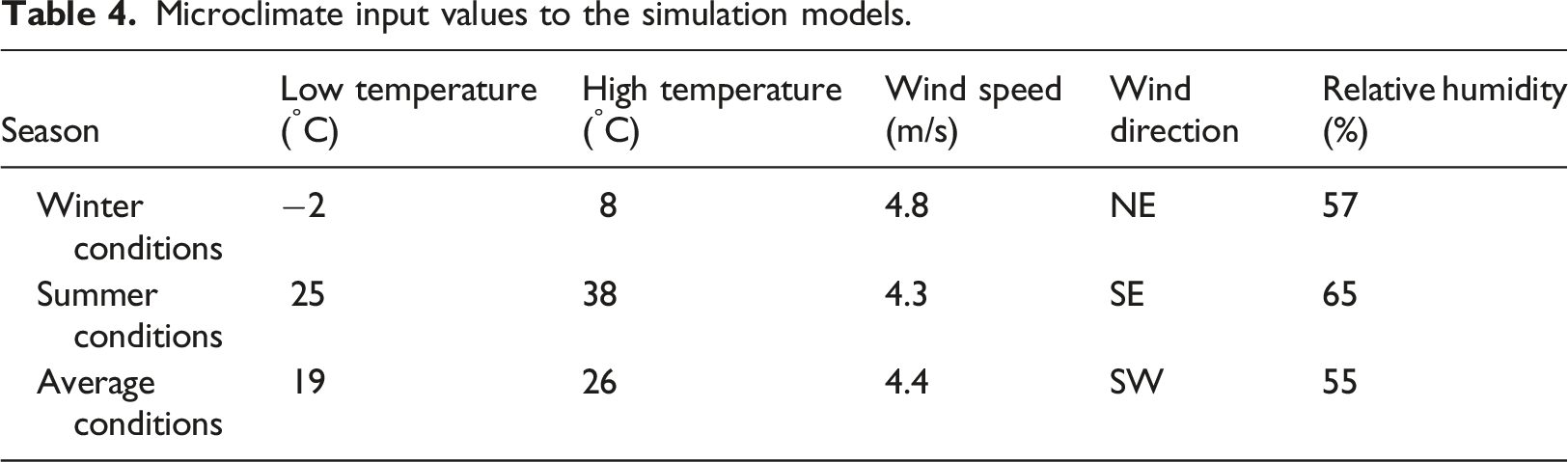
Microclimate input values to the simulation models.
Results
In this section, the comparative evaluation of the Bioclimatic Index is presented. First, microclimate simulation maps assist in the comparison of the effect of the studied methods on the urban microclimate of the different urban spaces in various Mediterranean locations. Second, based on the simulation results, the difference of the microclimate conditions, created in multiple points over all of the urban spaces, from comfort zones for climatic parameters, are calculated. Finally, the outputs of these measurements are compared with the calculated values of the Bioclimatic Index to assess indicator accuracy, transferability, and scalability.
Microclimate simulation results
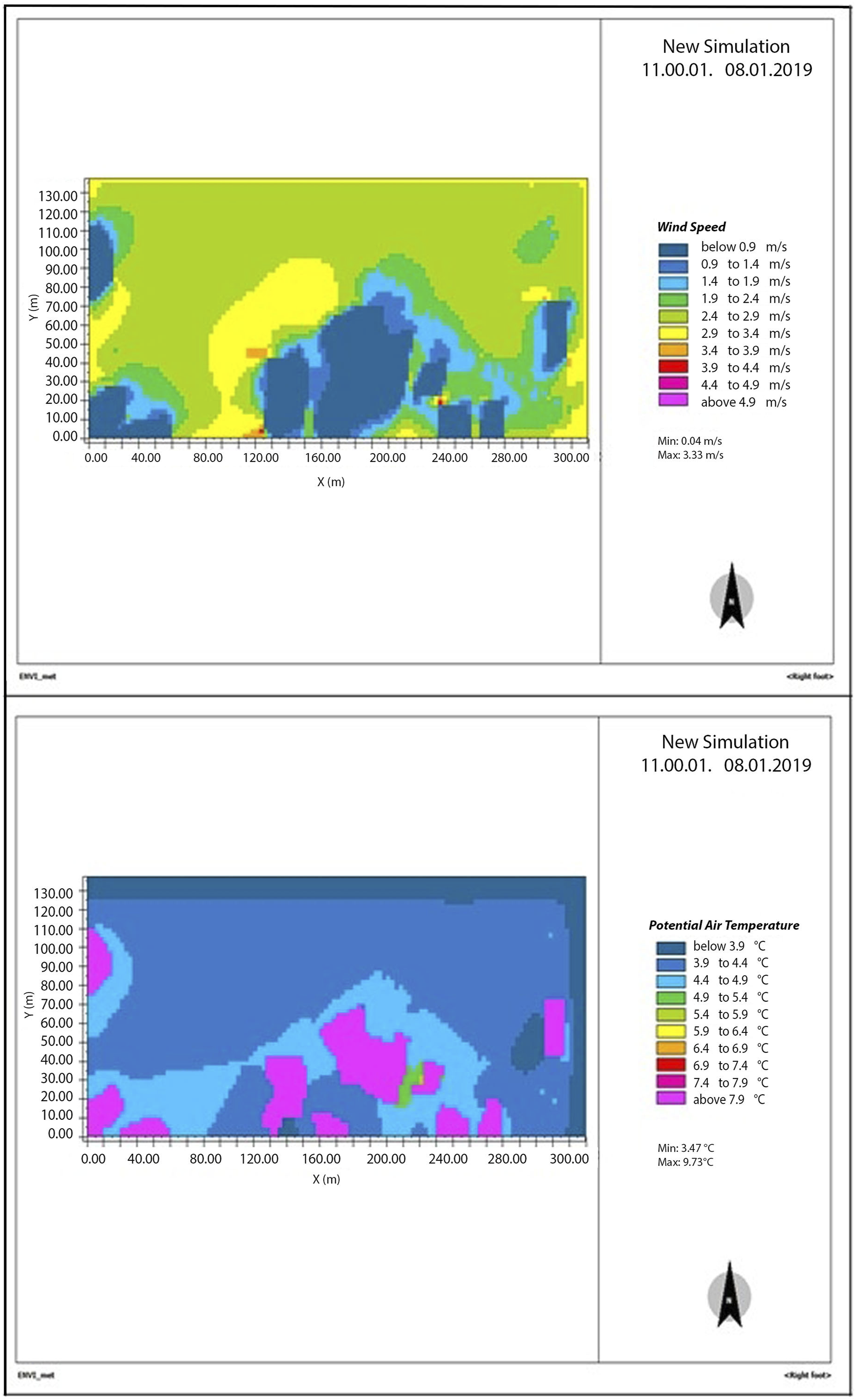
Simulation is used in order to suggest the microclimate conditions expected to be created by the studied urban methods. Within a wide range of microclimate parameters, the air temperature (°C) and wind speed (m/s) in each intervention are selected as the criteria for the comparative evaluation process, since relative humidity remains stable between 55 and 65% in all cases. Based on this selection, the air temperature and wind speed values identified at pedestrian level (+1.5m) for each of the urban spaces are presented indicatively for winter conditions at 11 a.m. in the isothermal maps of Figures 7–9. (a) Wind speed (m/s) and (b) Air temperature (°C) values in the New Costal Αrea of Thessaloniki at 11.00 a.m. in winter. (a) Wind speed (m/s) and (b) Air temperature (°C) values in the Ancient Port of Genoa at 11.00 a.m. in winter. (a) Wind speed (m/s) and (b) Air temperature (°C) values in the Coastal Front of Malaga at 11.00 a.m. in winter.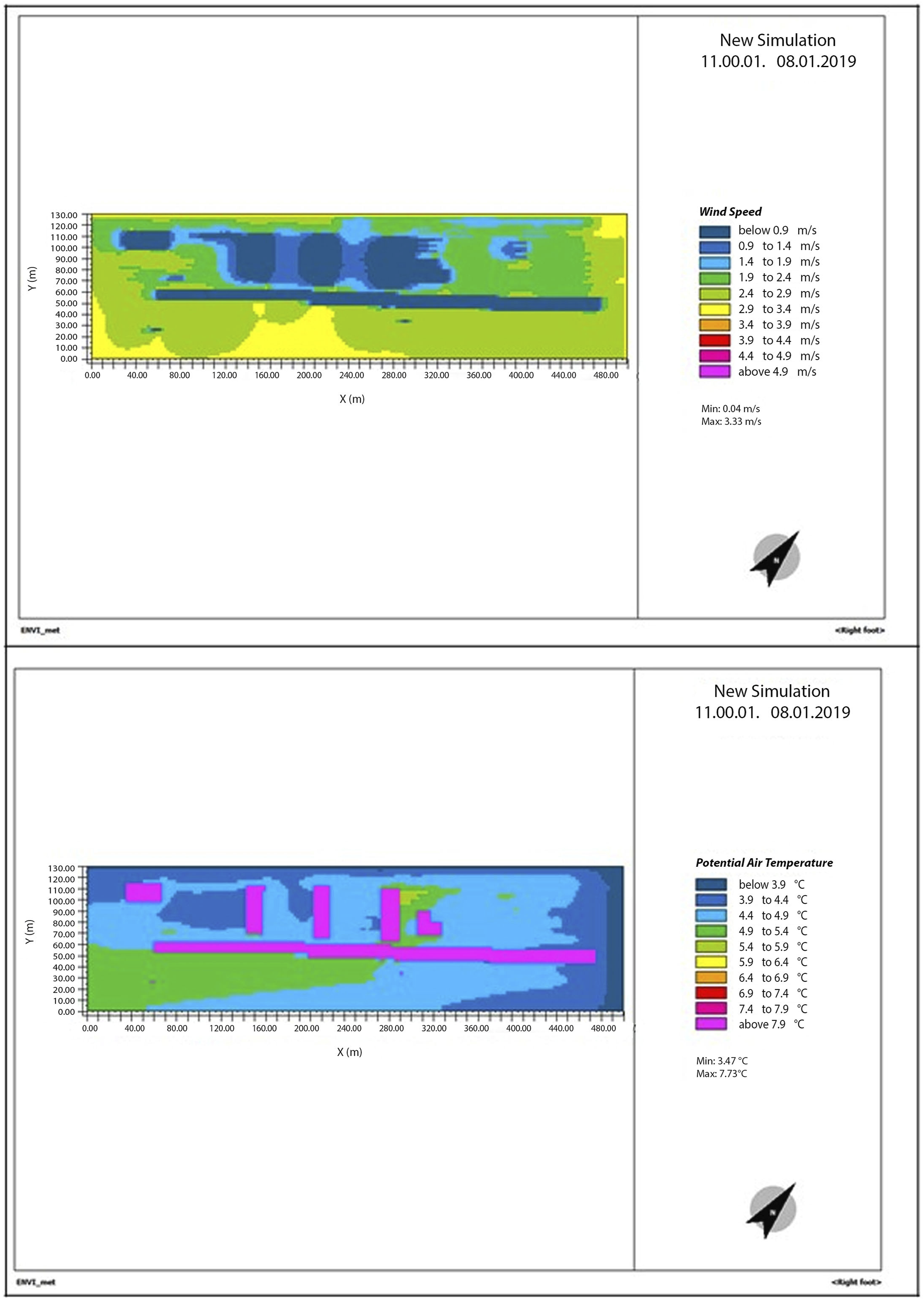
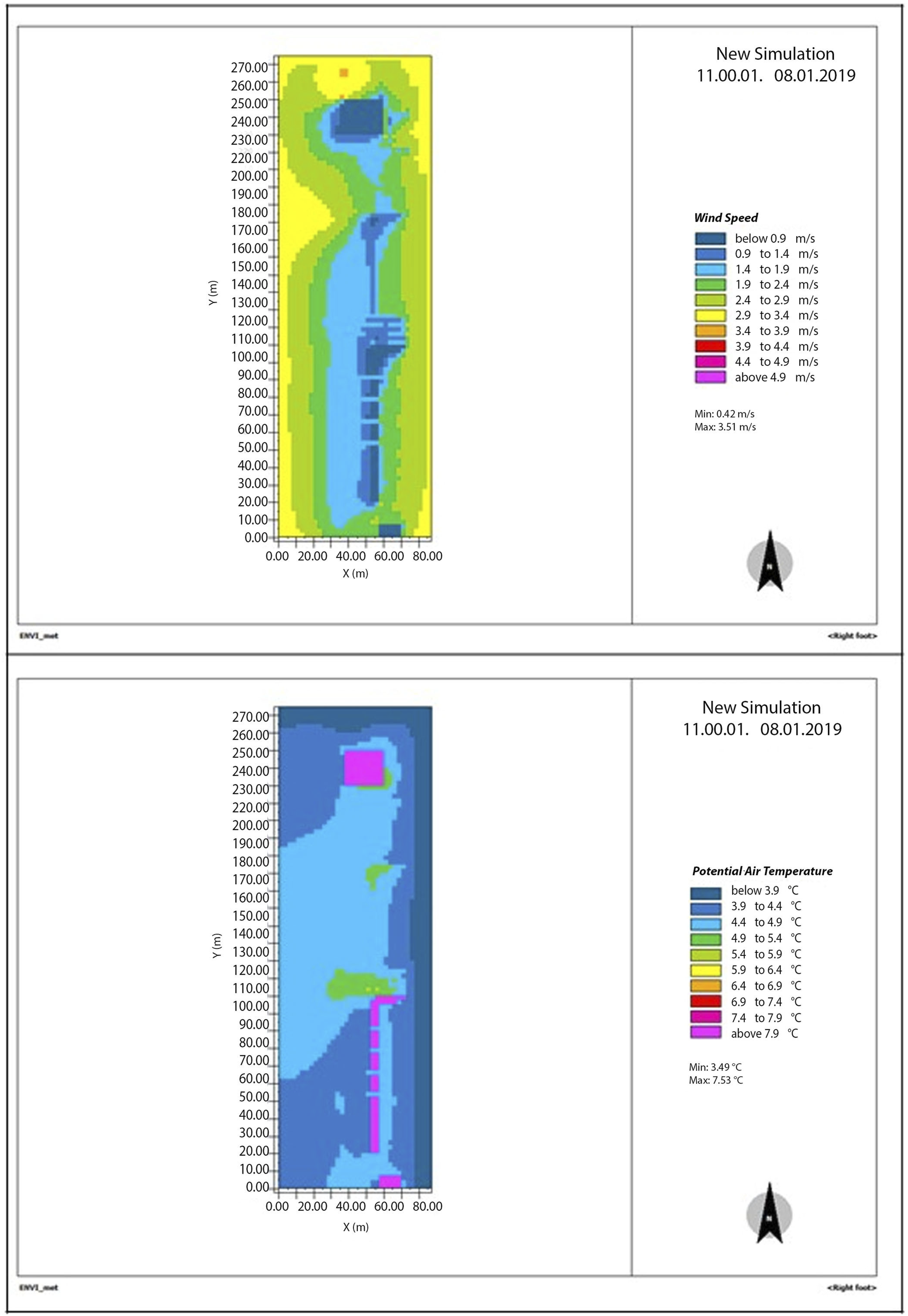
The maps show that in the greatest part of Malaga’s urban space, the wind speed values extend between 1.90 m/s and 3 m/s. While a large part of the coastal front, mainly in the gardens between the buildings, has lower values, between 0.9 m/s and 1.90 m/s.
In addition, in most sub-areas of the New Coastal Αrea of Thessaloniki, the wind speed is observed between 1.4 m/s and 3 m/s. The wind speed values are lower only next to buildings. In the case of Genoa, wind speed values are identified mainly between 2.4 m/s and 3.4 m/s. It is concluded that the values in Genoa are higher than those observed in the two other areas, creating more difficult microclimate conditions for the winter season.
Regarding the air temperature, in Malaga, the values are primarily between 4.47°C and 4.97°C while there are higher values found in a substantially large portion of the urban space that is between 5.47°C and 5.97°C. Accordingly, in Thessaloniki, most of the temperature values are between 3.97°C and 4.97°C, which is lower than in Malaga by 1°C. Finally, in Genoa, the estimated values are even lower. As shown on the map of Figure 8(a), the overwhelming percentage of the temperature values are between 3.97°C and 4.47°C. Therefore, it is observed that, on average, the microclimate conditions are more favorable in the urban space of Malaga than in the New Coastal area of Thessaloniki and lower in the space of Genoa, regarding the case of winter conditions.
Assessment of the Bioclimatic Index
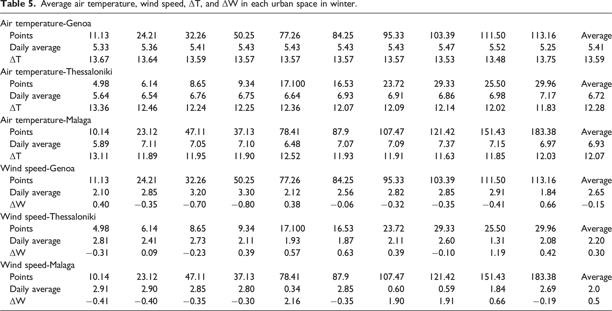
To better compare the simulation results with the values of the Bioclimatic Index, it was decided to extract the results for the microclimate simulations in multiple points of the studied urban spaces that are spread all over the regenerated area. Based on the simulation results, the daily average air temperature (


Average air temperature, wind speed, ΔT, and ΔW in each urban space in winter.
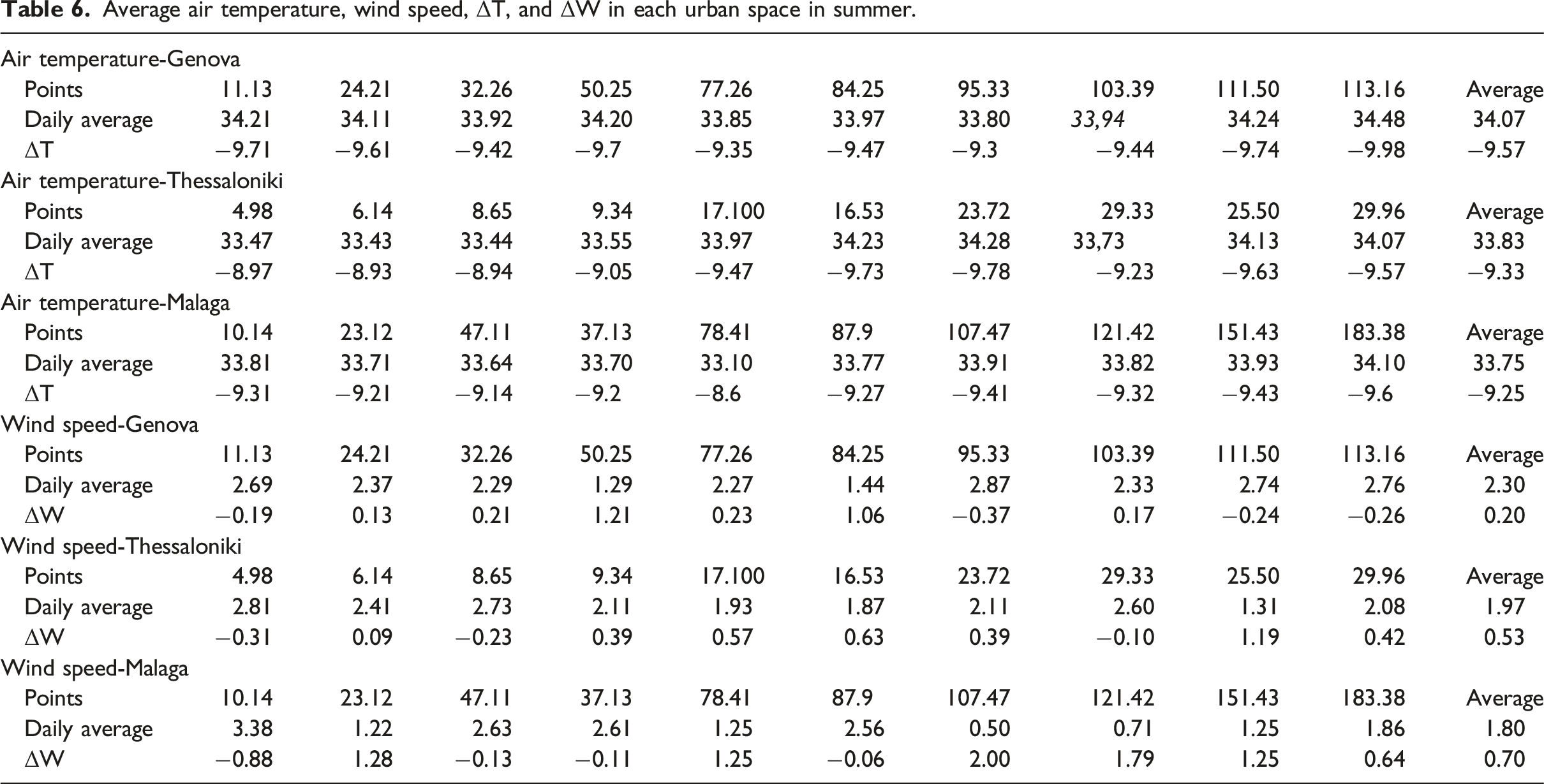
Average air temperature, wind speed, ΔT, and ΔW in each urban space in summer.
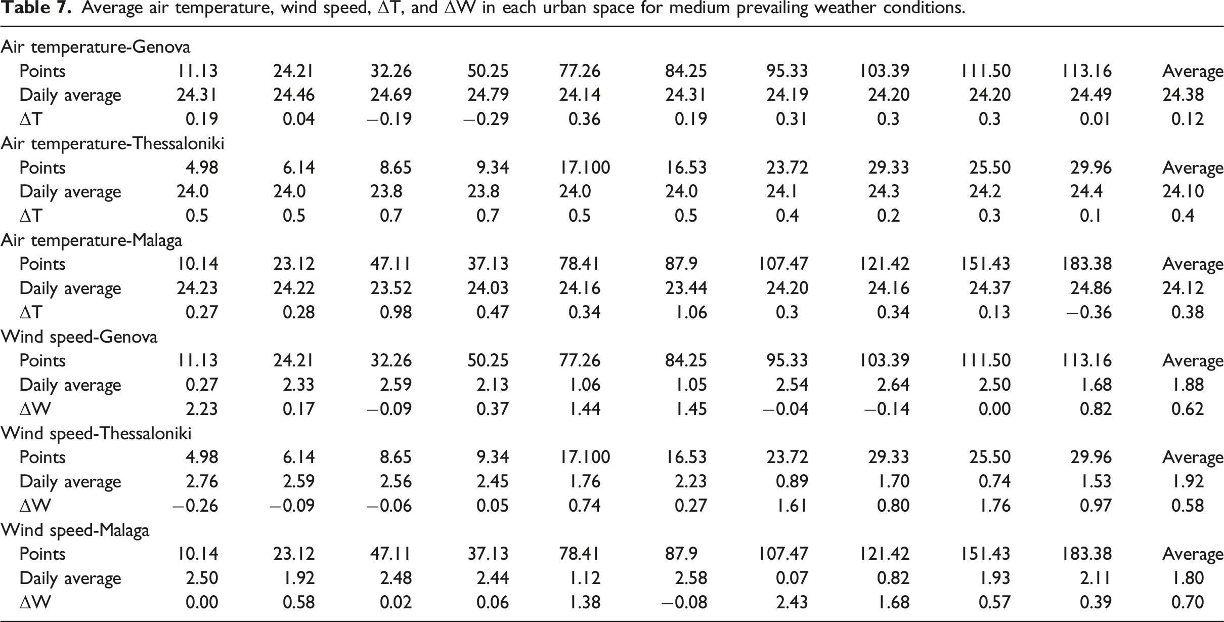
Average air temperature, wind speed, ΔT, and ΔW in each urban space for medium prevailing weather conditions.
According to the results of Table 5, the air temperature prevailing in Malaga is higher on average than in Thessaloniki. At the same period, the lowest temperatures are detected in Genoa, leading to worse microclimate conditions compared to the other two areas. As far as air conditions are concerned, the wind speed in Malaga is lower by 0.20 m/s than in Thessaloniki and by 0.65 m/s compared to Genoa. In addition, it should be noted that in the first two areas, the wind speed is under the comfort limit of 2.5 m/s, while in contrast, the conditions in Genoa reach 2.65 m/s, exceeding the comfort limit. The simulation results follow the rating of the Bioclimatic Index for the case study areas, evaluating the open space of Malaga as optimal, confirming the efficiency of the indicator and the ability to be used widely in multiple locations.
Regarding summer, the air temperature, identified in Table 6, showed that the average temperature is higher in Genoa than in Thessaloniki and in Malaga. Moreover, in Thessaloniki, the temperature conditions are worse with a slight difference compared to Malaga. In addition, the wind speed in Malaga as well as in Thessaloniki is lower, with the lowest value identified in Malaga. Instead, the wind speed value is greater in Genoa and near to the wind speed comfort limit (2.5 m/s). It is concluded that in the case of extreme summer conditions, the most favorable conditions are created in the urban space of Malaga, followed by Thessaloniki and finally by Genoa. In this case, the simulation results confirm the bioclimatic rating of the three urban spaces as well as the accuracy and transferability of the Bioclimatic Index.
Regarding the medium weather simulation results, presented in Table 7, the air temperature in Malaga and Thessaloniki are lower than the upper thermal comfort limit (24.5°C) while in Genoa, the air temperature is higher and very close to the comfort limit. As far as the wind speed is concerned, it is very low in all case studies although the lower value is identified in Malaga while the urban spaces in Thessaloniki and Genoa create similar wind conditions. It is concluded that, in this case scenario, the estimated wind conditions are not fully in line with the Bioclimatic Index classification of the three areas.
Conclusions
The current research focused on the assessment of the Bioclimatic Index for open urban spaces that supports the implementation of urban planning methods and interventions enhancing urban resilience. The effectiveness and transferability of the indicator is under study in order to identify if the Bioclimatic Index can be used in different locations and spaces of multiple scale.
To evaluate the proposed methodology and the proposed score of urban planning methods in the Bioclimatic Index, three coastal regenerated spaces in Mediterranean transportation hubs, and specifically in Malaga, Thessaloniki, and Genoa, were selected for the research. The application of the proposed methodology in other open spaces with a Mediterranean climate, which are located close to the sea, is assessed positively as the convergence of the expected weather conditions with those resulting from the climate simulation in the three regions is high. Therefore, the Bioclimatic Index and the proposed rating of different urban planning methods are applicable to other urban areas regardless of scale and also extent.
Weaknesses and deviations from the expected classification of areas are mainly found in medium-sized weather conditions. However, the results confirm the provision that the regeneration plans create and offer thermal comfort and wind protection. Finally, it is worth noting that the difference in air temperature and wind speed values of the studied areas are indicative and follow the differences among the three regions' scores according to the Bioclimatic Index. The small difference estimated among the scores of the open spaces is reflected in the small differences identified for the air temperature and wind speed values in the simulation results
Further research is proposed to focus on the standardization, classification, and extendibility properties of the Bioclimatic Index through the identification and evaluation of additional types of urban planning methods. In addition, more classes of planning scenarios and regenerated urban spaces could be simulated and rated, across a wider range of climatic conditions in various urban scales and sub-areas (e.g., city center, suburban areas).
Footnotes
Declaration of conflicting interests
The author(s) declared no potential conflicts of interest with respect to the research, authorship, and/or publication of this article.
Funding
The author(s) disclosed receipt of the following financial support for the research, authorship, and/or publication of this article: This work was supported by the Greece and the European Union (European Social Fund- ESF) through the Operational Programme «Human Resources Development, Education and Lifelong Learning» in the context of the project “Strengthening Human Resources Research Potential via Doctorate Research” (MIS-5000432), implemented by the State Scholarships Foundation (ΙΚΥ).