
Abstract
A large proportion of European inhabitants live in dispersed urban settlements, much of which is labelled as sprawl, defined by monofunctional, low-density areas. However, there is increasing evidence that this may be an overly simplistic way of describing territories-in-between (TiB). This paper defines and maps functional mix in six dispersed urban areas across Europe, applying a method that goes beyond existing land-use-based mixed-use indicators but considers functional mixing on the parcel level. The paper uses data on the location of economic activities and the residential population. It concludes that, in eight cases from four European countries, mixed-use is widespread and that more than 65% of inhabited areas are mixed. Moreover, the paper relates functional mixing to specific settlement characteristics: permeability, grain size, centrality and accessibility, and connectivity. This demonstrates that functional mixing is not the result of local urban morphology or planning instruments, but of the multi-scalar qualities of a location. Therefore, there is a requirement to coordinate planning and design through different scales if mixed-use areas are to be seen as one strategy for achieving greater sustainability in the spatial development of dispersed areas.
Introduction
Over the last decades, a significant amount of urban growth in Europe has taken place in a dispersed form (Hanzl, 2010; Kasanko et al., 2006; Salvati, 2016; Salvati and Tombolini, 2018). Much of this growth is labelled as sprawl, suggesting that urban development is predominantly low density, functionally segregated, or monofunctional, and is therefore considered unsustainable. In contrast, some authors (Borsdorf, 2004; Phelps and Wood, 2011) also report that some dispersed areas in Europe have entered a state of post-suburbia, which goes hand in hand with ‘densification, complexification, and diversification of the suburbanisation process’ (Charmes and Keil, 2015: 581). This paper investigates the type and location of economic and residential activities, their mix and their spatial relationship to different settlement structures in eight territories-in-between (TiB) (Wandl et al., 2014) across Western Europe in order to explore whether, and how, mixed-use has manifested within TiB. TiB are highly typical for Europe with their dispersed settlement patterns which, morphologically as well as functionally, are neither distinctly urban nor rural. TiB do not only exist in metropolitan regions but also along many of Europe's coasts and rivers, along transport arteries—preindustrial as well as modern corridors—and in valleys of European mountain chains. The necessity for urban expansion, which was not entirely slowed down by economic stagnation between 2008 and 2016, will rise significantly in the following years, triggered by a shortage of houses in many European countries. Therefore, it is timely to investigate the current state of dispersed urban areas. It is crucial to understand which spatial configurations within dispersed urban areas provide a mix of use and where there is potential to develop mixed-use areas in order to increase the potential sustainable development of TiB. The findings are relevant for both the planning and design of dispersed urban areas. This paper answers the following three research questions: (1) Are dispersed urban areas across Europe predominantly monofunctional? (2) How does functional mixing manifest in TiB? (3) Which settlement structures facilitate mixed-use environments?
Key concepts: Mixed-use, sprawl and territories-in-between
Mixed-use has been one of the most dominant urban planning and design paradigms over the last 50 years as it is often related to economic profitability, increased health (Frank et al., 2006; Stevenson et al., 2016), urban vitality (Jacobs, 1961; Kang et al., 2020) and sustainable transport behaviour (Cervero, 1989; Ibraeva et al., 2020; Newman and Kenworthy, 1996) as well as increased safety in public space (Bellair and Browning, 2010; Padukone, 2014). There has also been criticism, as mixed-use strategies often coincide with high-density development, which sometimes has a negative connotation (Brewer and Grant, 2015). Moreover, higher rent prices are also often related to mixed-use development. A critic to mixed-use implementation specifically relevant to the context of dispersed urban development is, as Brewer and Grant (2015) argue, that ‘different kinds of households and consumers live in the suburbs than in the urban core […] and that the […] characteristics of residents affect the kinds of businesses that can thrive in mixed-use environments’. Moreover, as Grant (2002 in Hoppenbrouwer and Louw, 2007) stated, mixed-use promises economic vitality, social equity and environmental quality. However, mixed-use cannot readily deliver such benefits in a context where cultural and economic forces promote the separation of land uses.
The most cited definition of mixed-use is from Rowley (1996: 87) who defines it as ‘involving different uses that occupy discrete parts of a building, block, or area. As a result, people come and go for differing reasons and on varying time-schedules’. Herndon (2011) adds, based on literature and planning documents, that multiple functions have to be physically and functionally integrated in a substantial way to attract their markets, as well as that mixed-use must maximise space through intensive land-use and should be pedestrian-oriented. Dovey and Pafka (2017: 250) add a relevant aspect to the definition by emphasising that mixed-use is a question of mixing through scale, or as they argue ‘mix is inherently multiple and that cities work as a mix of mixes’.
Measuring mixed-use
There are crucial differences between mixed land use and functional mix, although both are used interchangeably in most literature. Following Dovey and Pafka (2017), mixed land use follows a modernist way of thinking based on functional separation and insufficiently considers the mixing of functions on a single plot or building. This scale is crucial considering the above-presented definition of mixed-use, as otherwise, the smallest scale of the mix, the one of the plot or within one building, is omitted. Therefore, whenever we are talking about mixed-use in this paper, we mean a functional mix. Detailed reviews on mixed-use measures have been published by Dovey and Pafka (2017) with a focus on functional mix by Song et al. (2013) who investigated measures of land-use mix as well as Yue et al. (2017), who concentrated on points of interest. Table 1 gives a brief overview of the most commonly used indices describing their applicability as well as suitability for this study. The list omits most of the land-use-based indices as well as proxy measures, like centrality, grain size and building-age composition, as these are not mixed-use measures, but describe characteristics of the settlement structure, which will be elaborated in Sections ‘The spatial structure of mixed-use’ and ‘Measures describing settlement structures’.
Overview of different mixed-use indicators.
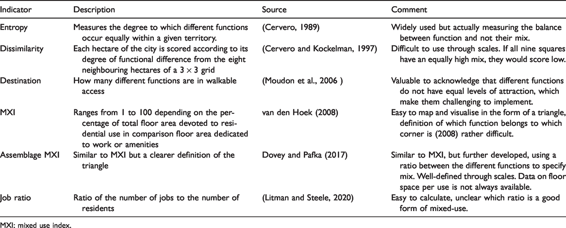
MXI: mixed use index.
The spatial structure of mixed-use
Mixed-use is addressed in two primary forms. First, in referring directly to the mix of functions at a minimum level of scale. Second through proxies in describing the main spatial morphological properties of the physical environment, namely grain size and fragmentation, density and distribution of the built form, accessibility and centrality of a location as part of the urban street system, and the diversity of spatial structures.
Rowley (1996) states that mixed-use ‘essentially is an aspect of the internal texture of settlements’. He identifies ‘grain, density, and permeability - derived from the layout of roads, streets, and paths’ as essential features of a settlement's internal texture. Hausleitner and Berghauser Pont (2017) developed an integrated spatial structural typology that allows for the assessment of programmatic performance, also mixed-use (Hausleitner, 2019). Such a typology allows a systemic—multi-scalar and multi-variable—understanding of the different urban conditions. Hausleitner and Berghauser Pont (2017) used built density with the measures of compactness (GSI) and intensity (FSI) of space and openness to describe the distribution of built form within an urban block as well as the plot-density to understand the grain of land-division.
Furthermore, building on work of Vaughan et al. (2010) and Crucitti et al. (2006), they used topological choice to understand the centrality of a location within the urban street network system. Lucan (2012) emphasises the diversity of urban form as a key for mixed-use and highlights that the edges of French cities built in the 20th century show a high level of homogeneity, with little variation in urban form as well as function. To summarise, the literature states that mixed-use can be related to density, centrality, small grain size and high permeability, always investigated at a specific location but also in the surrounding and related street networks.
The European dimension of sprawl
Dispersed urban areas are often falsely classified as sprawl. Therefore, we provide, in the following paragraph, a short overview of the European discussion on sprawl. The most comprehensive European research investigating sprawl over the last couple of years resulted in the EEA-FOEN report (2016) entitled ‘Urban Sprawl in Europe’. It defines urban sprawl as a phenomenon that can be visually perceived in the landscape. A landscape [is affected by urban sprawl] if it is permeated by urban development or solitary buildings and when land uptake per inhabitant or job is high. A higher degree of urban sprawl is characterised by the more occupied an area is in a given landscape (amount of built-up area) combined with the level of dispersion in this built-up area (spatial configuration) and the higher the uptake of built-up areas per inhabitant or job (lower utilisation intensity in the built-up area). The term 'urban sprawl' can be used here to describe both a state (the degree of sprawl in a landscape) as well as a process (increasing sprawl in a landscape). (EEA-FOEN, 2016: 22, with reference to Jaeger and Schwick, 2014) It understands sprawl as a state and process. It does not rely on an urban–rural dichotomy but uses the concept of landscape.
The same report also provides a comprehensive review of the positive and negative effects associated with sprawl, which is summarised and slightly extended in Tables S1 and S2 in the Supplementary Material. From Tables S1 and S2, it is apparent that many of the adverse effects of sprawl, such as longer commuting times, a higher generation of CO2 because of increased car use, and less social interaction, are also often related to the absence of mixed-use. Some of the positive effects of sprawl such as less conflict between residents and production companies, as well as more space for distribution infrastructure, have been related to the absence of mixed-use. It is essential to note that in the EEA-FOEN report (2016), the number of jobs accounted for was only included in the mapping and analyses of the drivers of sprawl at the country and NUTS2 levels, but not at the smallest aggregation unit (1 km × 1 km) due to a lack of data. Whether a 1 km grid cell is considered sprawl or not is independent of its level of mixed-use.
Territories-in-between
As many of the currently available territorial classifications suffer from similar difficulties of including jobs at the local scale, or a lack of integration between land use and population density, we will use the classification of TiB developed by Wandl et al. (2014) in our investigation of dispersed urban territories for the spatial analyses.
TiB is introduced by Wandl et al. (2014) as an umbrella term, to describe and map dispersed settlement patterns, and to avoid the simple distinction of spatial structure into ‘urban’ and ‘rural’, and is not limited by cultural connotations that come with some other terms like Zwischenstadt, because those terms belong to a specific place and are not generic. The characteristics of TiB include: (1) that they form a complex interlocking system of built and open spaces; (2) that their existence is highly influenced by the connecting and separating role of infrastructure at different spatial scales; and (3) that they often exhibit a complex mix of land cover. It is possible to map TiB, departing from these literature-based and theoretical qualities. Wandl et al. (2014) did this in 10 areas across Europe. For a full description of the method, the reader may refer to the original research paper.
Cases, methodology and data
This section introduces the eight cases investigated and explains how the typology of settlement structure, as well as the degree of mixing, is based on analyses through three different scales. Furthermore, spatial proxy variables for both settlement characteristic and mixed-use are introduced. Finally, the section explains the development of a typology of settlement structures and elaborates how different types of settlement structures demonstrate different levels of mixed-use.
Cases
This article is part of more comprehensive research, which compares TiB across Europe, in order to understand how planning approaches and spatial performance are interrelated. Location and key information for the cases are provided in the Supplementary Material. The cases are South-Holland (NL), The Tyrol (A), North Somerset (UK), Vienna-Bratislava (A), Gelderland (NL), Bergamo-Brescia (I), Veneto (I) and South Wales (UK). The cases were selected to represent different ideal types of spatial planning (Nadin and Stead, 2013) across Europe, a variety of different topographies from coastal to alpine zones, as well as to include dispersed urban areas in metropolitan regions, but also areas where a dispersed development pattern evolved without the presence of large cities. For a detailed explanation of the choice of the cases, we refer the reader to an earlier publication (Wandl et al., 2014).
Spatial levels
The cases introduced previously are analysed using three spatial scales. In an urban context, the scales that are commonly used include the building, the block, the district and the city. As this paper aims to understand the organisation of mixed-use at the regional scale and to inform regional planning, three scales of analyses have been defined: The first scale includes an extent of 50 km by 50 km squares, of dispersed urban development in Europe, which differ in planning culture, topography and history. The squares are subdivided into TiB, as well as into urban and rural areas. The second scale is the areas classified as TiB within the 50 km by 50 km. These are the specific territorial classes of interest to this paper. 500 m × 500 m grid cells are the smallest resolution for the spatial analyses. The rationale behind this is: (i) 500 m is a feasible distance to integrate different uses for pedestrians, which represents the often-neglected vertical and intra-cadastral mix; (ii) a smaller resolution would imitate a sense of preciseness that the current data available do not allow; and (iii) a larger spatial unit may, because of data aggregation, lead to a situation where the results are not spatially differentiated.
Selected measures of mixed-use
The review of the definition and measures of mixed-use indicated that mixed-use is generally present if more than two functions are found within the same spatial unit. Two measures are used to describe mixed-use: (1) the number of different economic activities and (2) the ratio of the working population to residential population within one area.
The jobs to people ratio (M) is calculated according to the following formula.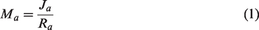
The second index calculates the number of distinct types of functions within one spatial unit. To specify the number of different functions, the statistical classification of economic activities (NACE) in the European Community (EUROSTAT, 2008) was used. EUROSTAT (2008: 43) also provides a standardised aggregation of 11 groups of economic activities. In all eight case studies, information of all registered and active companies comes from the ORBIS database (Dijk, 2018). This database provides, for each company, a four-digit NACE code as well as information about the section a company belongs to. See Table S.3 in the Supplementary Material.
Additionally, the address for each company is registered. These data were used to generate a point shapefile that represents the geographic location of each company. The information on the specific activity is aggregated to the different spatial aggregation units and allowed us to assign a value of mixed functionality between 0 and 12 to each spatial unit. If mixa = 0, then there is neither an economic activity nor residential population present in areas a. If mixa = 12, the then all 11 groups of economic activities, as well as residential population, are present in the area.
Measures describing settlement structures
A set of measures, which are explained in detail in the Supplementary Materials, for grain, density, permeability, centrality and accessibility, were used to describe settlement structures to understand whether specific settlement structures perform differently according to mixed-use. All these measures were calculated for the 500 m × 500 m grid cells and were combined in a spatial database.
Building a typology of internal settlement characteristics
We assigned the values for all of the above-described measures of inner settlement structures to all 500 m to 500 m grid cells, which were classified as TiB, for all cases and stored them in a geodatabase. Using SPSS, a two-step cluster analysis was performed to identify different types of internal settlement structures. This exploratory statistical method allows running cluster analyses on large data sets that are not normally distributed and include categorical variables. Other commonly used clustering methods cannot be applied under these circumstances. The resulting typology consists of eight clusters, which represent different types of the typology of settlement characteristics. To understand whether or not the different types perform differently concerning mixed-use, we carried out a Kruskal–Wallis H test. This is a rank-based nonparametric test that can be used to determine if there are significant statistical differences between two or more groups of independent variables. Through this methodological choice, in contrary to many mixed-use studies that aim to establish causal relationships between mixed-use and other factors, we acknowledge the complexity of these interrelations, which cannot be expressed by simple correlations.
Results
The first subsection of the results section presents two mixed-use measures in order to answer the following questions: Are TiB functionally segregated (as generally assumed) when considered equally to sprawl? By mapping the two measures of mixed-use, the jobs to people ratio (M) and the number of different types of economic uses (Mix), an answer is presented to the second question: how is functional mix spatially manifested in TiB? The second subsection answers if this differentiation is related to the characteristics of the spatial structure.
Mixed-use in territories-in-between
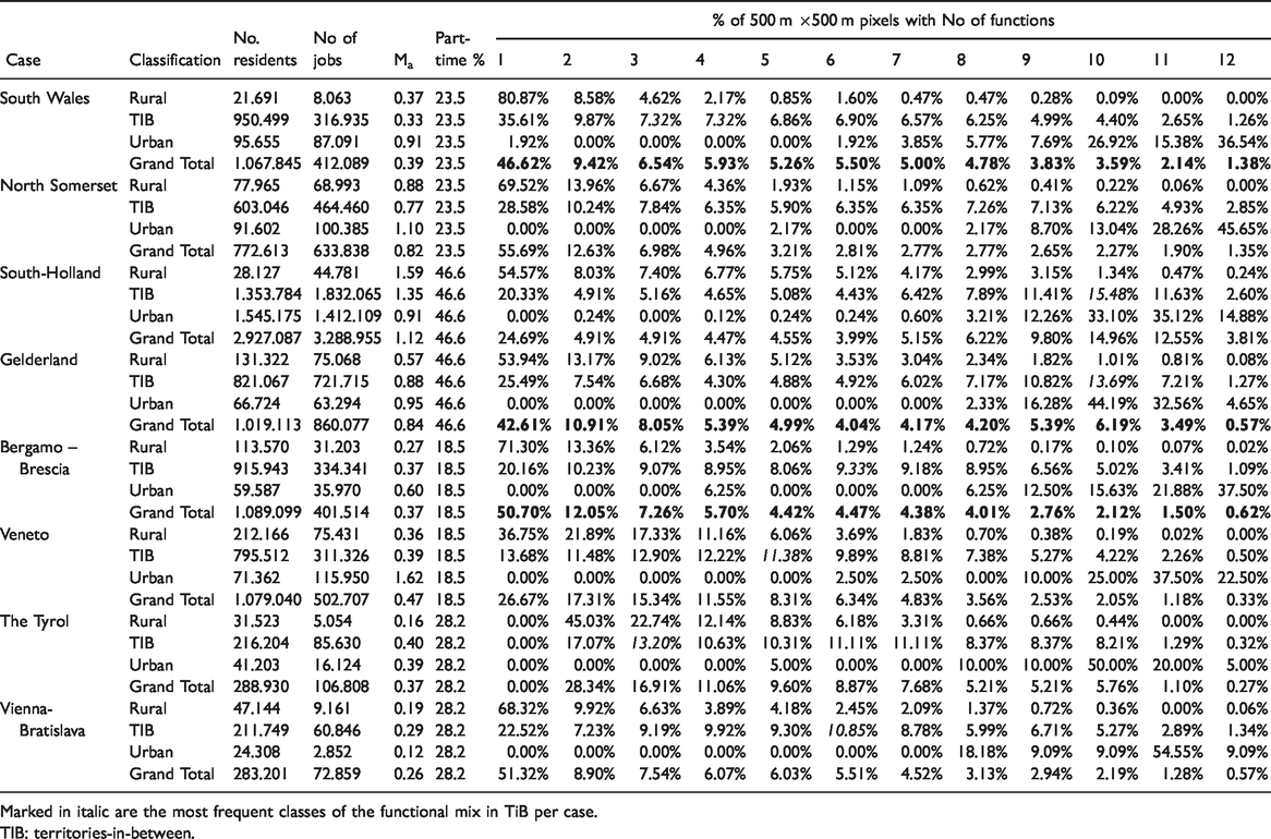
Table 2 shows the two mixed-use indicators, the job to residents ratio [Ma] and the percentage of different functions aggregated for three spatial units, the whole case study area, the areas classified according to Wandl et al. (2014) as rural, urban and TiB as well as for the inhabited 500 m × 500 m grid cells. The conclusions across all cases are that mixed-use is an incremental characteristic of European urbanised areas, whether they are dispersed or not. In six cases, more than 65% of the inhabited grid cells host three or more functions. The British cases are an exception, with 61% for North Somerset and 55% for South Wales. An apparent result is that there are, in all instances, differences in the frequency distribution for urban, TiB and rural areas. Most cases show that in rural areas, low mix classes (1–4) are dominant. The TiB shows an equal distribution across all mixed-function-classes, often with a peak around class six. In the urban areas, the highly mixed classes (9–11) dominate in all cases. The Tyrol and the two Dutch cases show the highest mix in TiB. The Dutch cases show a higher overall mixed-use, where grid cells that host ten functions are the most frequent. Although North Somerset has the most monofunctional grid cells, it presents the third-highest job to resident ratio in all TiB. In this case, mixed-use areas are more clustered compared to other cases, which is visible when comparing the maps of Figure 1 that show the spatial distribution of the number of functions per 500 m × 500 m grid cell. This comparison allows us to identify three types of territorial forms of mixed-use: (1) clustered following a network of cities, town and villages, like in North Somerset, Vienna-Bratislava and the southern part of the Bergamo-Brescia area; (2) a dispersed form of mixed-use that follows corridors like valleys and coasts (Tyrol and South Wales) or infrastructure corridors (Bergamo-Brescia and Gelderland); and (3) a field-like dispersed mixed-use area such as in South-Holland and the Veneto.
The mix of residents to jobs and the functional mix of inhabited 500 × 500 m cells for the eight case studies.
Marked in italic are the most frequent classes of the functional mix in TiB per case.
TIB: territories-in-between.
Maps of the spatial distributions of 500 m × 500 m pixels with the number of functions within TiB for all eight cases.
Typology of settlement characteristics
We used the measures above, describing the characteristics of settlement structures, as input variables for a stepwise-cluster analysis in order to answer the second research question of this paper. Is there a spatial-structural difference between mono- and mixed-use areas that can be used to inform planning and design? The result is a typology comprising eight cluster types with significantly different spatial settlement characteristics. Table 3 describes the key characteristics of the different types.
Key characteristics based on median values of each cluster and examples of aerial views from the different cases.
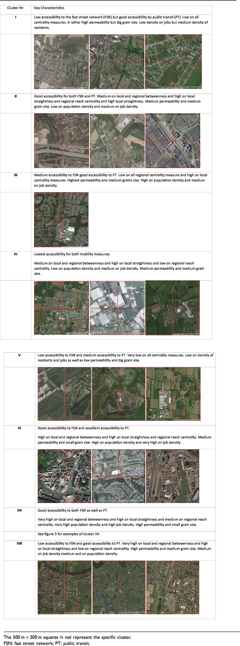
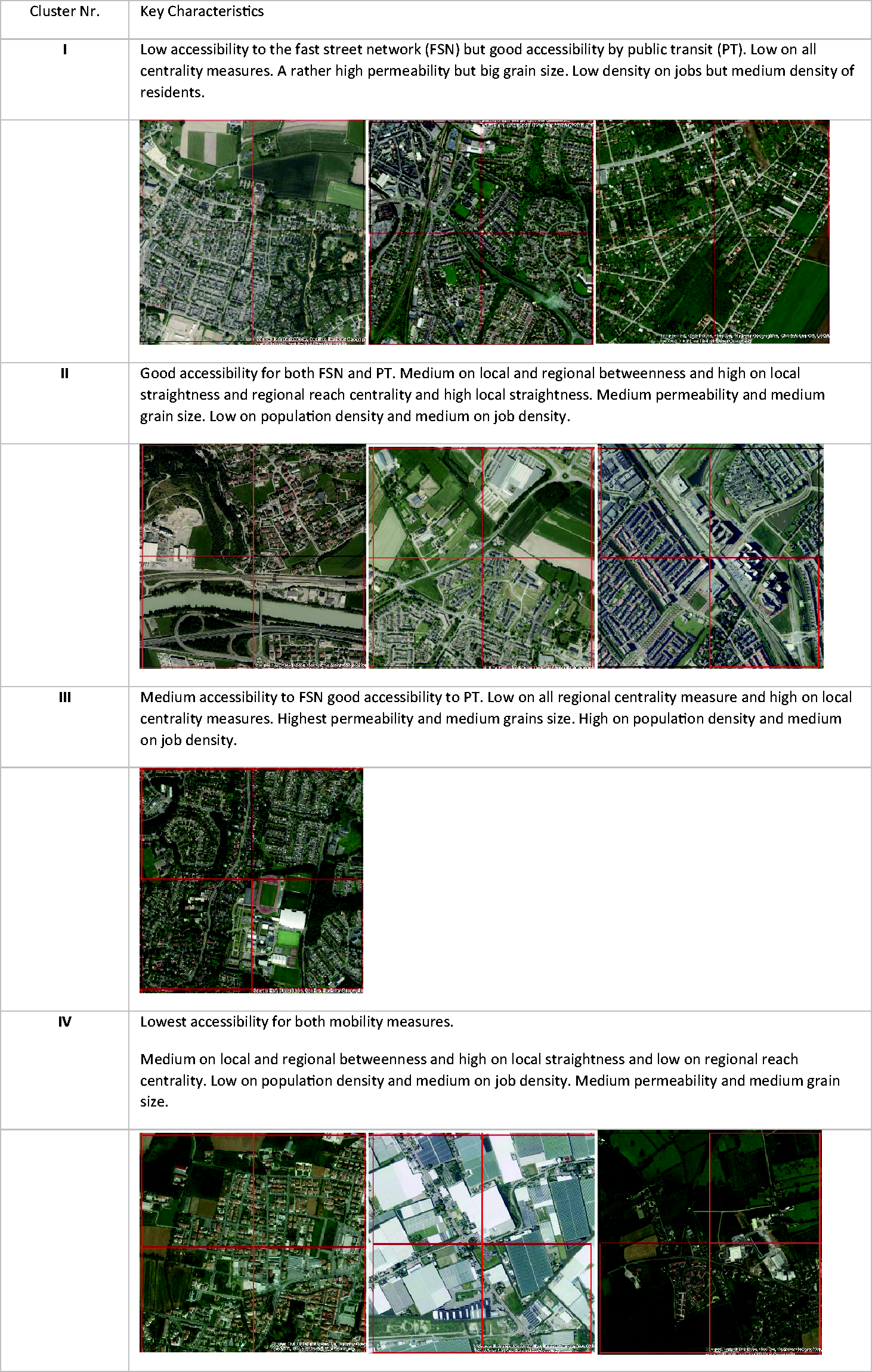
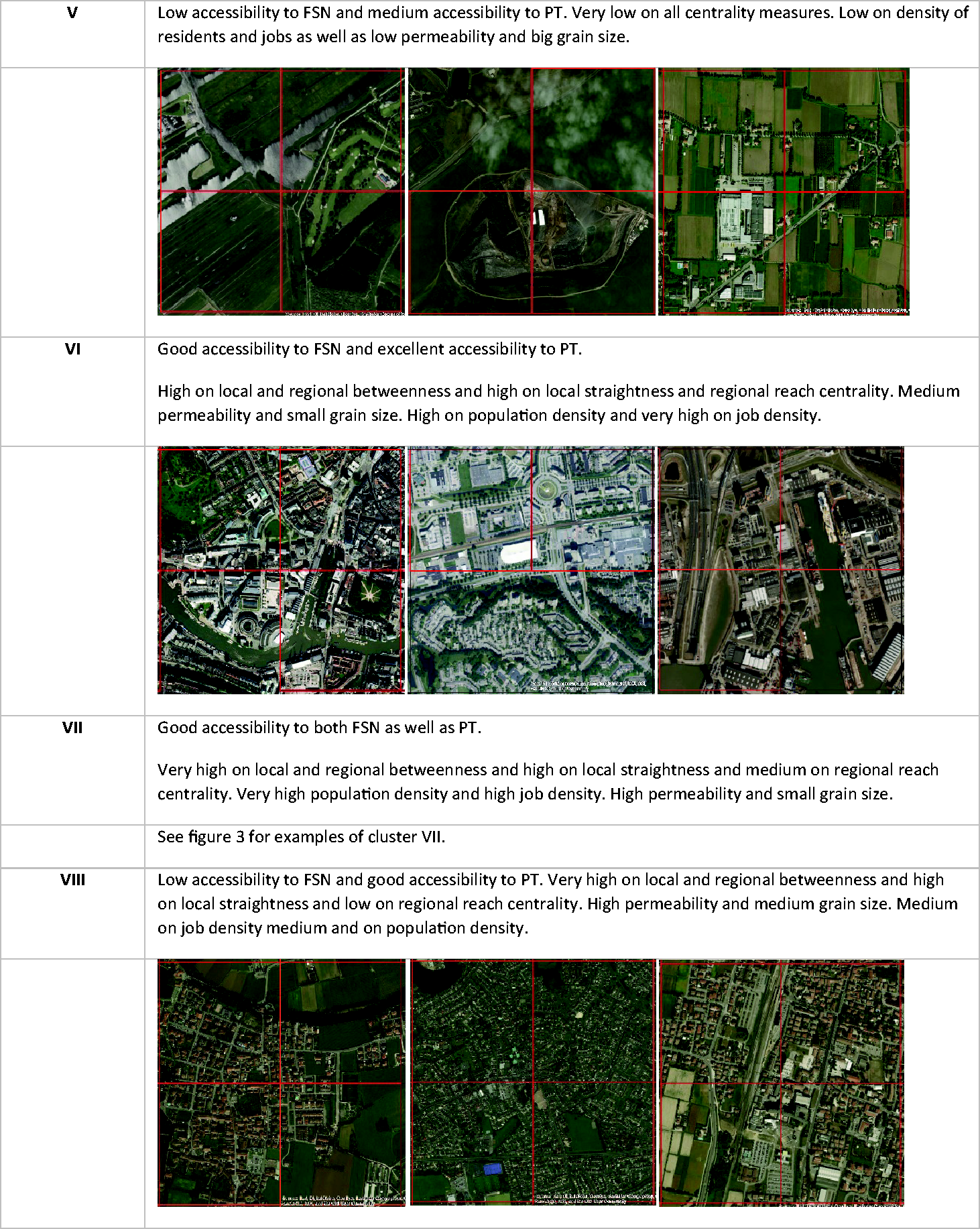
The 500 m × 500 m squares in red represent the specific cluster.
FSN: fast street network; PT: public transit.
Table S.4, in the Supplementary Materials, presents the frequency of the clusters for each case and shows that types I, IV, V, VI, VII and VIII are found in all cases. Type II is present only in the Dutch and Austrian cases whereas type III is present only in South Wales. Overall, the most frequent are type I and type VIII. Figure 2 presents the spatial distribution of the types in the case study areas. It shows that types II and VII concentrate around larger urban areas. Types I, III and VIII can be found in and around the smaller towns. Type V seems to concentrate on the edge of smaller villages. Type IV describes towns and villages, and type VI concentrates at the edges of Bristol and Rotterdam.
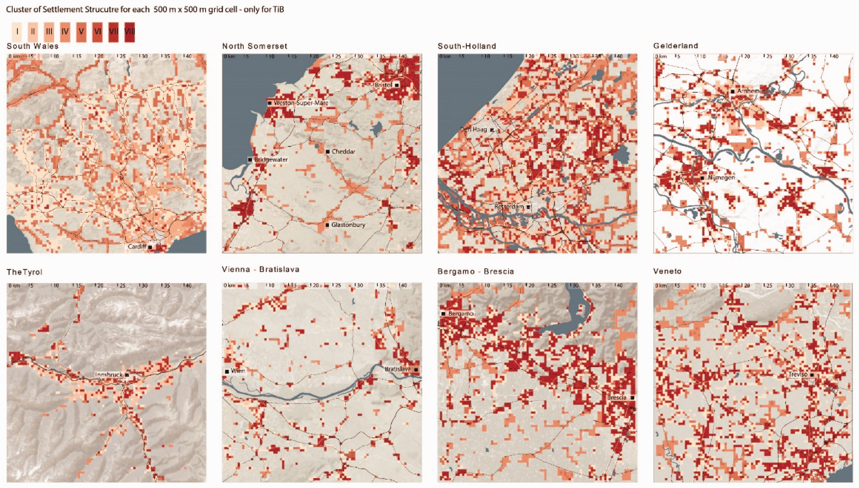
Maps showing the spatial distribution of the eight clusters of settlement structures in all eight cases.
The Kruskal–Wallis H test indicates that there is a statistically significant difference in mixed-use between the types of settlement structures, H (7) = 815.729, p = 0.0005. Pairwise comparisons were performed using Dunn's procedure with a Bonferroni correction for multiple comparisons, which showed that, out of the 27 pairs, only three pairs did not show significant differences according to mixed-use, notably type pairs III–VIII; IV–I; and V–II. Therefore, we can conclude that mixed-use is significantly different in the settlement types across all eight cases. Table S.5 in the Supplementary Material provides an overview of the frequency distribution of mixed function over clusters of settlement structure per case.
Conclusions and discussion
Do monofunctional areas dominate dispersed urban areas? The answer to the first research question is evident: More than 65% of the inhabited 500 m to 500 m grid cells host three or more functions; this means that a particular functional mix characterises TiB in Europe. The functional mix is manifested in TiB in two distinct principle forms: one, where both the density of inhabitants and jobs is relatively low, and the second, where the density of residents is comparatively high and accompanied by a mixture of economic activities, for the latter we can assume that those areas are also more lively.
The question now is, do the settlement types perform similarly concerning mixed-use in all cases? In all cases, type VII shows the highest functional mix as it is the type with the highest residential density, good accessibility by public transit, vicinity to motorway entrances and high permeability and small grain. Type II, which can only be found in the Dutch and Austrian cases, is the second type with a relatively high functional mix. However, in contrast to type VII, this type also includes monofunctional areas. Type VI, which is the smallest cluster class, shows in all cases an exclusively high functional mix, being located at the edge of the main cities in the Netherlands and England. Type III, only present in Wales, also shows a relatively high functional mixing but also includes monofunctional grid cells. Type V is the type with the least functional mixing in all cases. Type I is the largest cluster class overall and is less functionally mixed. Type VIII shows a rather indifferent image with a relatively high share of monofunctional grids cells but also many cells with a functional mix of around seven. Therefore, we can conclude that the presence of functional mix in dispersed urban areas coincides with similar settlement structures.
In the following section, we discuss examples of what areas with high functional mix look like and how the mix is spatially arranged. For Type VII, four exemplary cases were selected and illustrated in Figure 3(a) to (d). The most common mixed-use areas are historic (founded before World War I) town centres. All of them have a main or high street which is often also connected to a market or an intersection of regionally important roads. Figure 3(a) shows the town centre of Mogliano (Veneto). It displays how diverse the mix of functionality is and how it is arranged along the main streets and the squares of the town. Economic activities are also, to a certain extent, integrated with residential use, although areas of single-family houses host fewer economic activities. The railway station is close by, and larger parking lots are situated at the historic centre's edges.
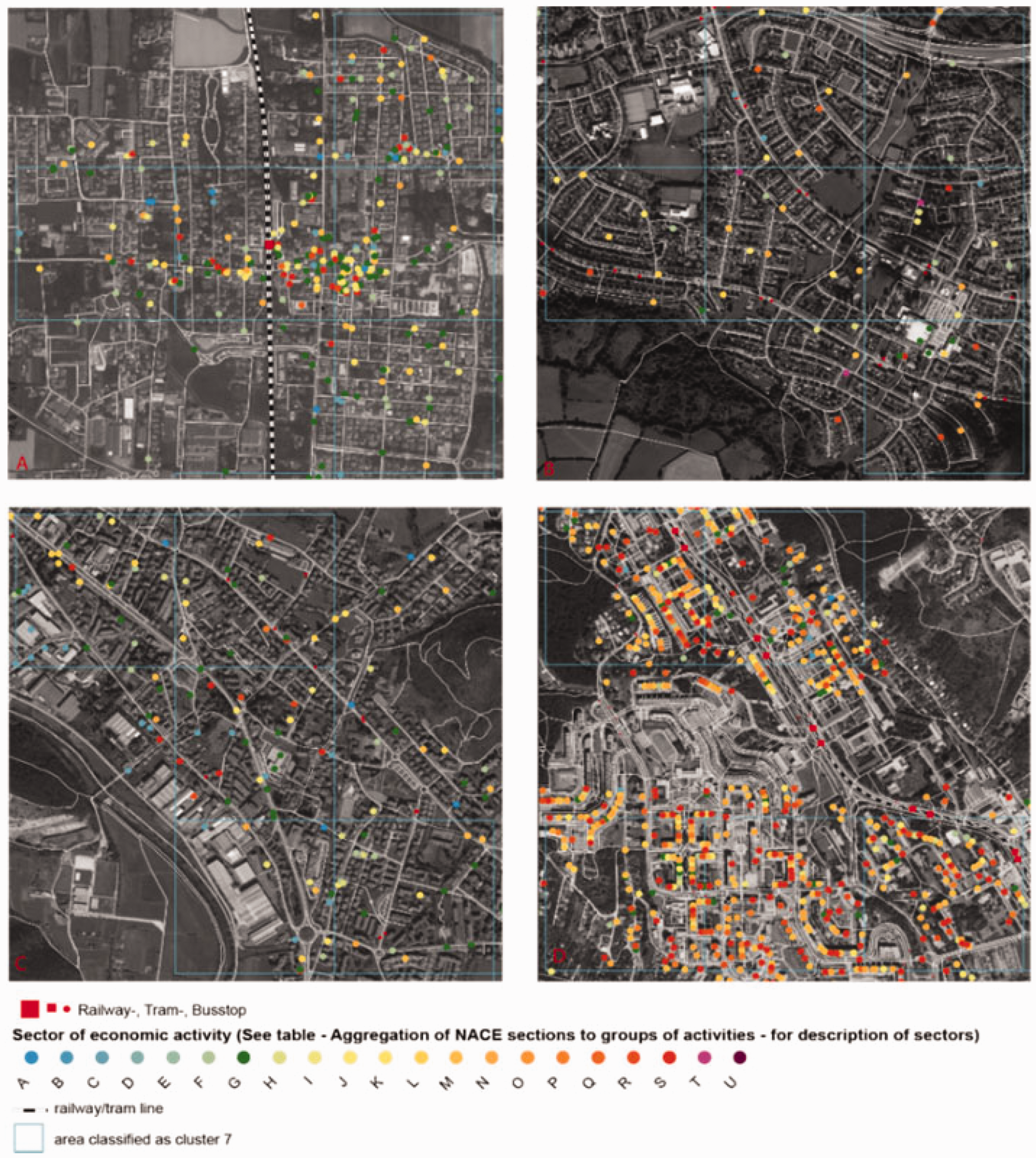
(a to d) Examples of different types of mixed-use areas of type VII.
The second example of mixed-use areas is the post-war suburban centre, which is also found in all cases, but more often in the Dutch and UK cases. Figure 3(b), which shows Hartcliffe, an outer suburb of the city of Bristol, demonstrates that most economic activities, specifically related to retail and other daily needs, are concentrated in a retail centre. Moreover, a variety of economic functions are situated in areas dominated by terraced or free-standing houses, which in the case of type VII are hardly ever cul-de-sac developments. Although those areas cater to the car, all functions are also integrated for pedestrian uses.
The third example of functional mixed-use areas is rather multi-use and not mixed-use because the areas are not integrated for pedestrians. Figure 3(c) presents a typical example of a business or industrial park next to residential areas in Concesio, north of Brescia (Italy).
The fourth type of mixed-use is relatively rare and concentrated explicitly on the Slovakian part of the Vienna—Bratislava case. It is mixed-use within areas dominated by multi-storey slabs (see Figure 3(d)). In this case, service and support functions with a relatively low number of employees dominate. These examples show that similar settlement structures and related mixed-use can be generated by very different looking local urban tissues and building types.
From the four examples we can conclude that two aspects are specifically relevant: (1) A small grain size with high permeability at the neighbourhood scale, which allows for pedestrian integration between more central places, historic or newly developed centres and (2) a central location in the street network at the regional scale. A more general analysis of the typology of inner settlement characteristics shows that functional mixing is significantly diverse between different types of settlement characteristics. The types with the highest mixed-use are characterised by (1) good accessibility to both the motorway system and public transport, (2) a very high local and regional betweenness, (3) high permeability and small grain size as well as (4) a higher population density and higher job density.
In the Dutch and Austrian cases, areas with medium local and regional betweenness, medium permeability and medium grain size, as well as low population density and medium job density, show a rather high functional mix too. This outcome may allow the conclusion that in both countries, policies and practices are in place that support mixed-use in less densely populated areas. Moreover, the typology shows that in types with high population density, this factor compensates for lower accessibility and centrality values.
A key recommendation for planning and regional design, in order to support or extend present mixed-use development, is to better integrate neighbourhoods adjacent to areas with pre-existing mixed-use. This can be achieved by increasing permeability and decreasing grain size as well as improving accessibility by public transit. High Streets are one apparent structure to build upon for such extensions.
For establishing new areas as mixed-use centres, it is reasonable to start from areas that already perform well in some of the settlement characteristics and improve the others, which in most cases will require collaboration between planning bodies at the local, the regional and even the national levels. Local governments can influence permeability and grain size, but changes in centrality measures typically require cooperation across multiple municipalities or regional planning authorities. Changes in both public transit and motorway accessibility often require national planning authorities to act.
In recent years there has been a significant investment in motorways, and national and bypass roads in dispersed urban areas, which have tremendously changed the spatial distribution and regional centrality, where entries to these streets have become central. Over the last decades, either distribution centres or strip malls, both monofunctional, have been developed in such locations. We consider this process a failure of integrated spatial planning, as these locations would also have a high potential for residential and, therefore, a mix of functions.
To summarise, we have defined and mapped functional mixing in six dispersed urban areas across Europe, applying a method that goes beyond existing land-use-based mix-use indicators and includes mixing on the parcel level and also vertically. In all cases, the level of functional mix can be related to settlement characteristics: permeability, grain size, centrality and accessibility and connectivity. This means mixed-use is not a result of local urban morphology or planning instruments but multi-scalar qualities of a location. Therefore, there is a requirement for planning and design to be coordinated through different scales if mixed-use areas are one strategy to achieve a more sustainable spatial development in dispersed areas.
This confirms, when looking at aspects of sustainable urban planning and design, that it is crucial to do so through scales, as the proposed typology did, by investigating three different scales, and not only at the local urban tissue. Although this research did not specifically look at the building scale of mixed-use, the variety of building types in the examples presented seems to suggest that it is of less relevance. Alternatively, as the authors think instead, the existing building types in TiB with high mixed-use are relatively flexible in hosting different economic activities.
Supplemental Material
sj-pdf-1-epb-10.1177_2399808320987849 - Supplemental material for Investigating functional mix in Europe's dispersed urban areas
Supplemental material, sj-pdf-1-epb-10.1177_2399808320987849 for Investigating functional mix in Europe's dispersed urban areas by Alexander Wandl and Birgit Hausleitner in EPB: Urban Analytics and City Science
Footnotes
Declaration of conflicting interests
The author(s) declared no potential conflicts of interest with respect to the research, authorship, and/or publication of this article.
Funding
The author(s) received no financial support for the research, authorship, and/or publication of this article.
Supplemental material
Supplemental material for this article is available online.
Biographical notes
References
Supplementary Material
Please find the following supplemental material available below.
For Open Access articles published under a Creative Commons License, all supplemental material carries the same license as the article it is associated with.
For non-Open Access articles published, all supplemental material carries a non-exclusive license, and permission requests for re-use of supplemental material or any part of supplemental material shall be sent directly to the copyright owner as specified in the copyright notice associated with the article.