
Abstract
Physical infrastructure networks in diverse urban settlements are designed to be robust and reliable, while the socio-economic systems offer the necessary adaptive capacity at household, city, and regional scales to recover from major service disruptions resulting from disasters. Here, our urban resilience analyses are based on exploring explicit links between the physical infrastructure/assets and the socio-economic systems. Increased availability of high-quality data from mobile devices allows quantification of diverse socio-economic metrics and thus enables tracking city- and regional-scale community recovery from disasters. Here, recovery trajectories for five regions within Puerto Rico island with differences in socio-economic status (e.g., median income) after Hurricanes Irma and Maria are analyzed using large-scale mobility data and are combined with earlier synthesis of seven global cities based on capital portfolio analysis. Systemic inequalities are manifested in highly variable ability to cope with chronic shocks and recovery from extreme events. Island urban communities face the geographic-isolation effect, legacy socioeconomic constraints, and chronic inefficiencies in governance, all of which delay recovery from disasters. Hurricane recovery efforts include two types of responses. First, in larger urban areas, households use their social ties and financial resources to evacuate to larger cities and return when damaged facilities and infrastructure are repaired. Second, smaller urban communities are already adapted to coping with inadequate critical services and experience disproportionate impacts of disasters. Lacking socio-economic resources, such communities self-organize to access local and external resources and actively engage in repairing and rebuilding damaged facilities. However, recovery is much slower than their counterparts in larger cities. Given the interdependencies of connected social and physical systems and cross-scale feedbacks, such inequalities must be addressed at both city and regional scales to continue progress in urban community preparedness for and recovery from disasters.
Keywords
Introduction
Urban communities rely on multiple critical services (e.g., water, sanitation, energy, communications, transportation, health services, etc.) provided by public and private utilities. In OECD countries, reliable services are available on demand, ensured by high connectivity to efficiently managed infrastructure. Cities in developing countries have unreliable provision of critical services, and consumers utilize diverse household adaptive strategies to just cope with and/or overcome chronic service deficits. For example, estimated percentages of communities served by intermittent water supply vary greatly, from 30% in Africa, to 60% in Latin America, almost 100% in India (Klingel, 2012), requiring most households to depend on access to household reserves (e.g., supply tanks above or below the house) or rely on alternate providers (home delivery by tankers; purchasing bottled water). The situation is similar for unreliable power supply and absence of sanitation systems (Roefs et al., 2017); often, the transportation and/or public health infrastructures are also overwhelmed. These chronic deficits in critical services together limit mobility, education, and employment opportunities, which combine to curtail social advancement and erode public health. For urban-poor communities living in informal settlements, persistent socio-economic inequalities further exacerbate the consequences of critical-service deficits. In many cities, in poor and developing countries, gradual deterioration of infrastructure from lack of maintenance and erosion of adaptive capacity from having to deal with high levels of chronic service deficits and many other challenges translate to low community resilience and vulnerability to collapse in case of extreme events. Infrequent but high-impact events, such as major disasters (e.g., earthquakes, hurricanes, tornadoes, floods, droughts, heat waves) trigger widespread loss of infrastructure, causing extended deficits of critical services.
There has been much work on disaster recovery of physical networks such as power grids (Rinaldi et al., 2001), transportation (Murray-Tuite, 2006), and water systems (Krueger et al., 2019b). Similarly, there has been work to understand the social effects on the recovery process (Siebeneck et al., 2020). However, we lack a clear understanding of the interplay between the physical and social networks and how each of the adaptive capacities embedded in these networks contribute to recovery. We posit that the ability to cope with chronic service deficits and to recover from disasters depends on the feedbacks (links) between two coupled complex systems: (1) socio-economic systems, which generate the demand for critical services and provide the necessary “capitals” required for sustaining community adaptive capacity to cope with service deficits, and (2) reliability of the technological systems (physical infrastructure networks) operated by public–private utilities, which manage infrastructure and acquire the needed natural resources (e.g., water, energy) to meet community demands for critical services. This hypothesis formed the basis for a coupled systems dynamics model proposed by Klammler et al. (2018), which was used by Krueger et al. (2019a) to examine city-scale water security and resilience of urban communities in several archetype global cities, with contrasting differences in several components of social capitals (infrastructure, financial, natural resources, governance) contributing to adaptive capacity. However, empirical time series data for chronic shock-recovery dynamics were not available for comparison with model simulations. Thereby, clear inferences to real-world applicability were limited in those studies.
At the household, city, and regional scales, urban communities vary in community resilience, revealing differences in their inherent urban adaptive capacity and resilience. Poorer parts of the cities and informal settlement communities often experience a disproportionate damage from the disasters, recover much slowly than the rest of the city, and lack socio-economic resources to cope with deficit of critical services. Urban resilience to disasters then requires access to external resources in addition to local efforts of city governments and social adaptive capacity developed within the communities. Such disaster assistance arrives from regional and national networks, and recovery of infrastructure may take days to few months, and often services remain below required performance levels to meet the community demands (i.e. chronic-deficits).
Geographic isolation of island urban communities, contrasted to continental cities, presents additional challenges in accessing the much-needed economic and technological assistance for disaster-recovery effects. We examine here U.S. Commonwealth of Puerto Rico as a case study of Small Island Developing States (SIDS). Caribbean SIDS are along the path of several hurricanes and major storms, which cause significant damage to infrastructure and housing as well as natural ecosystems. The lack of required technical and economic resources delays community recovery. Our understanding of SIDS is further limited due to the lack of spatio-temporal data for socio-technical system states and recovery.
Our analyses are motivated by two primary questions: (1) How do different degrees of interdependence (linkage) between socio-economic and technological complex systems drive disaster-recovery dynamics in Puerto Rico communities at the regional scale (aggregation of multiple urban settlements, based on connectivity)? and (2) Is there correlation or sequencing in recovery trajectories of multiple indicators of socio-economic dynamics and critical service deficits? We utilize anonymized mobile phone data for visits to several key points-of-interest (POIs) as direct indicators of social mobility dynamics to assess post-hurricane recovery trajectories of coupled social-infrastructure systems. Based on publicly available data from utilities, we also examine recovery of water services in these five regions after Hurricane Maria. We use Puerto Rico data analyses to discuss disaster resilience of other Caribbean SIDS and offer guidelines for enhancing island community resilience. To provide a context of urban resilience in water systems and disasters, we discuss case studies in urban resilience next which will be a starting point for our research questions.
Case studies of urban resilience
Rapid urbanization and major advances in sensing technologies, as well as data and network sciences, have transformed our understanding of structure and functions of interdependent urban networks and their management to reliably provide multitude critical services to urban residents. These advances form the foundation for designing and managing smart, resilient cities. Recent research and case studies in diverse cities have also improved our understanding of evacuation-return dynamics during/after extreme events (hazards such as flooding; hurricanes; earthquakes; etc.) (Yabe et al., 2020a). Yet, enhancing community resilience in smart cities, aligned with the United Nations’ Sustainable Development Goals (SDGs), requires significant advances in addressing socio-economic inequality and increased access to critical services to informal settlements in major cities.
There is no consensus in how “urbanization” is defined; different countries not only employ different types of metrics but also use different thresholds (Our World in Data, 2017). Often distinction is made between urban and rural communities based on population density, yet with mostly gradual spatial transitions it is difficult to distinguish when one ends and the other begins. We suggest that connectivity to infrastructure networks and centralized management providing critical services may be more useful metric. On this basis, decentralized and distributed critical services (water, sanitation, power) are more common to “rural” settings to accommodate the low population densities. But, for road networks, this distinction is not useful (Strano et al., 2017). Furthermore, “urban” and “rural” settings are interdependent in commerce, food, education, technological and social innovations, and ecosystem services. For these reasons, we consider these to be connected and interdependent human settlements. Urban settlements of different populations and areas are embedded in the landscape otherwise occupied by managed lands (e.g., agriculture; forests; etc.). At a regional scale, it is best to conceptualize multiple cities as dynamic networks with heterogeneous nodes, with “flows” of goods, people, and information, as articulated in Christaller’s “Central Place Theory” (see Christaller (1933); King (2020); Ullman (1941); Krugman (1993); Goodall (1987)). Germany (which is the region of focus for Christaller (1933)) serves as an excellent case study for such designation, with nearly 100% connectivity to centralized critical infrastructure regardless of the size and location of settlements within three large river basins. Large cities are usually located near the river basin outlets, with decreasing size of settlements as distance to outlet increases (see Yang et al. (2019)). This human settlement scaling pattern is consistent with earlier reports of globally consistent fractal spatial organization of human settlements (Fang et al., 2018).
In the following sections, we discuss urban resilience at the regional and city scales. We used empirical time-series data for disaster loss-recovery dynamics across five regions in Puerto Rico after Hurricanes Irma and Maria as well as results from earlier works on water security and resilience of seven global cities. Results highlight the regional differences in the recovery dynamics of social and physical systems from various shocks.
Resilience at the regional scale: Hurricane impacts and recovery
Urban communities on large and small islands face unique problems in recovery efforts, being surrounded by water and cutoff from the relief available to coastal and inland cities on the “mainland.” Urban communities in island states/nations in the Caribbean represent such unique cases for disaster resilience. Puerto Rico’s geographic location is along the path of many hurricanes and major storms, which cause significant damage to infrastructure and housing as well as natural ecosystems, and lack of required technical and economic resources delays recovery.
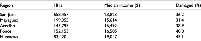
We select Puerto Rico as the case study region and Hurricanes Irma and Maria as the disaster events because of their substantial and longitudinal disaster impacts on the island, causing power outages and water shortages for the entire island for several months (Román et al., 2019). As of 2020, Puerto Rico’s population stands at 2.87 million, a loss of ∼600,000 through emigration, since Irma and Maria hurricanes. Puerto Rico is among the larger islands in the Caribbean (∼8870 sq km), with 94% of the population being urban (largest city San Juan, 347 K population) and economically developed (US$32K median income per capita) compared to its neighboring Small Developing Island States (SIDS) (United Nations Department of Economic and Social Affairs, 2010).
We are motivated by two primary questions related to urban disaster resilience in island states/nations: (1) How do island communities cope with repeated cycles of major disasters, like hurricanes (Puerto Rico and its Caribbean neighbors) and earthquakes (e.g., Puerto Rico, Haiti)? (2) How do recovery dynamics of these urban communities vary across the island and from cities in the U.S.? We posit that island nations in the Caribbean, given their long history of colonization and current socio-economic problems, have limited internal resources needed for recovery from disasters. They cope by adapting to chronic lack of critical services and relying on local innovations.
We examine recovery within Puerto Rico after two back-to-back Hurricanes (Irma and Maria) to understand differences in community resilience, which emerges from the interdependence of physical infrastructure and social systems at the regional scale. Data on the restoration process of critical services and the recovery of commercial activities were used as metrics to quantitatively assess urban disaster resilience.
Puerto Rico data and analysis
The service deficit data for physical systems in Puerto Rico were publicly available on the “StatusPR” (http://status.pr/) website, which was active after Hurricane Maria until August 2018. The website updated daily data on physical systems’ functionality from various public utility organizations in Puerto Rico, including water services provided by Acueductospr (AAA), electricity provided by the Puerto Rico Electric Power Authority (AEE), and telecommunications (JRTC). We use the data collected by a private Github account (Padilla, 2017). In Puerto Rico, the only physical service deficit metric that contained disaggregated regional performance values was water service deficit, provided for the five regions: metro, north, south, west, and east, which correspond to the five partitioned regions in Figure 1. In this study, we use water service deficit recovery data as a proxy for the recovery dynamics of physical infrastructure systems. Strong physical co-location characteristics of various critical infrastructure systems suggest that water systems could serve as an appropriate proxy for the heterogeneous critical infrastructure systems (Klinkhamer et al., 2017).
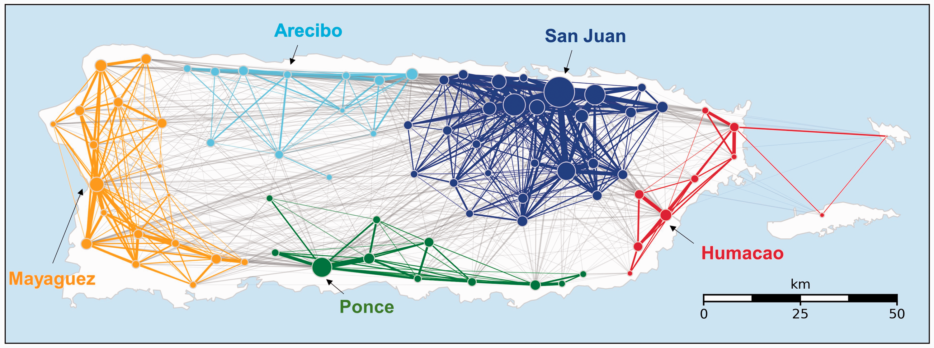
Partition results of counties in Puerto Rico based on pre-disaster human mobility flow dynamics network. Each sub-network is labeled by the major cities, respectively. These subnetworks describe the regional clusters that have significant intra-regional mobility flow. The sizes of the nodes correspond to the population in each county, and the width of the links connecting each node represents the amount of mobility flow during normal times (before the hurricane). The links connecting nodes from the same subnetworks are colored with the color of the subnetwork, otherwise colored in gray.
Large-scale data collected from mobile devices (e.g., mobile phone location data, social media data) and low-cost sensors have enabled us to observe the recovery of social and physical systems at an unprecedented spatiotemporal granularity and scale (Blondel et al., 2015). Location data collected from mobile phones have been used to estimate the number of people visiting various POIs to assess the vitality of the establishment (Gurun et al., 2020). Studies have applied such large-scale mobility data to quantify the impact of natural hazards on human behavior (e.g., Lu et al. (2012); Wilson et al. (2016)). However, no studies have used such data to infer and understand the interdependencies that may exist between social and physical urban systems.
We used data collected by Safegraph, a company that collects anonymized location data from around 10% of all smartphones in the United States. Each observation is consisted of a unique (but anonymized) user ID, longitude, latitude, and timestamp information. The longitude and latitude information are accurate to within a few meters, allowing us to analyze the visit counts to each establishment. GPS data were obtained from mobile phones of individuals who agreed to provide their location data for research purposes, and all information were anonymized to protect the security of users. Using the mobile phone location data, the number of daily visits to each POI were estimated.
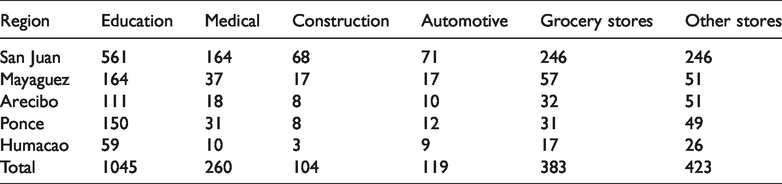
Table 1 shows the number of POIs in each region in each category. Regional socio-economic data (i.e. population data and median income data) were obtained from the American Community Survey. Housing damage percentages refer to the portion of houses approved for the “Individuals and Households Program” of FEMA in each county (Federal Emergency Management Agency, 2018). The POI daily visit dataset contains the name, category, geographical location (longitude and latitude), and daily visit counts of individual POIs. POIs in six major and essential categories: education, medical, construction, automotive, grocery, and other stores were used in the analysis.
Number of POIs by type and region in the dataset.
Regional-scale recovery
In all five regions within Puerto Rico, water service deficit decreased in an exponential manner (Figure 2) over a five-month period (17 September 2017–18 February 2018). Data were observed only after 29 September 2017; thus, missing are the observations of initial service deficits between 20 September and 29 September. Water service deficit recovery were fitted against a negative exponential function (
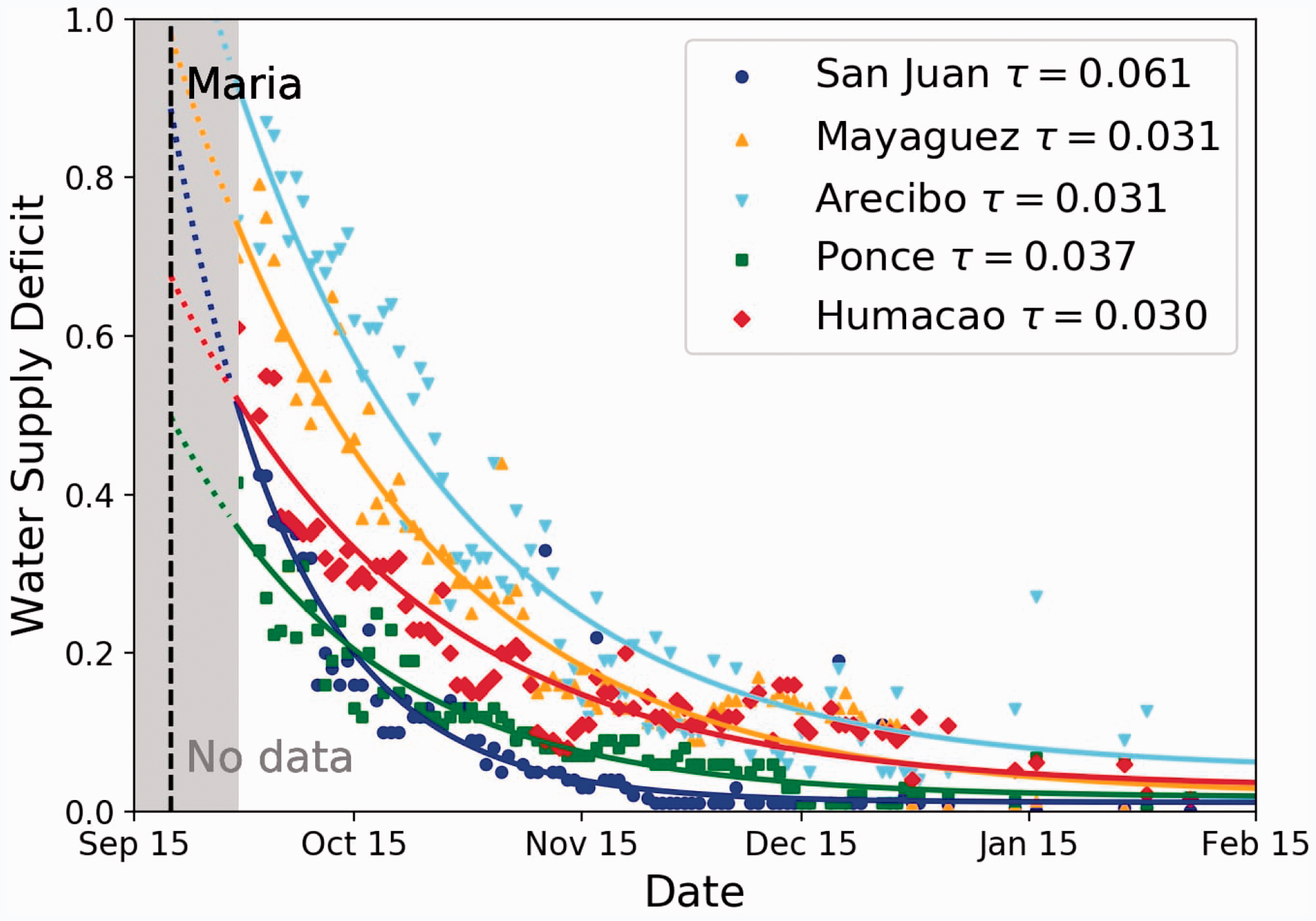
Inter-regional heterogeneity in recovery dynamics of water service deficit in Puerto Rico after Hurricane Maria. The data can be fit well to a negative exponential function
Socio-economic characteristics of the five regions in Puerto Rico.
Estimated parameter values and goodness of fit of social and physical recovery models.
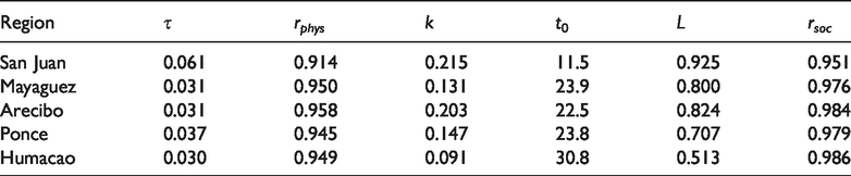
The scatter plots and the solid lines in Figure 3 show the recovery dynamics of aggregated visits to all POIs in each of the five regions based on mobile phone data. The recovery observations, despite the differences in speed, all resemble a logistic growth, which can be modeled with the following equation
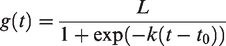
Inter-regional heterogeneity in recovery dynamics of visits to various POIs in Puerto Rico after Hurricane Maria. The data can be fit well to a logistic growth function
The foot traffic values start at a low value close to 0 and gradually recover to a stable value near L with decreasing growth rate as the value approaches the stable value in the long term. The steepness (rate) of the curve is characterized by parameter k, and the midpoint timing (timing when recovery reaches
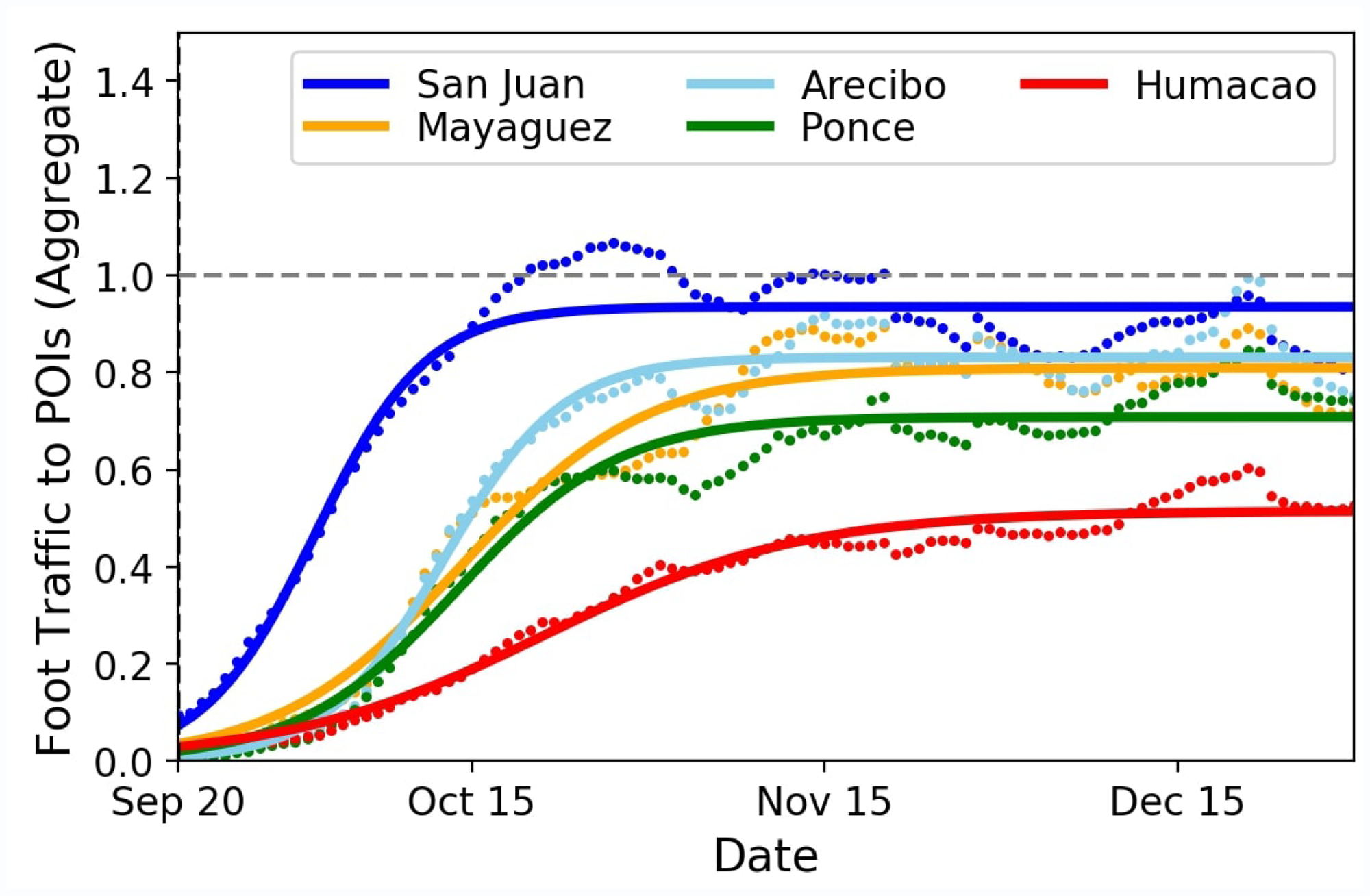
By dis-aggregating the foot traffic data to various POI types, we observe significant increase in visits to all of the POIs in all regions just before the landfall of Hurricane Maria and also before Hurricane Irma for medical and construction POI types (Figure 4). This implies significant pre-disaster preparation behavior (e.g., shopping for goods), which agrees with insights from past human behavior modeling studies (Yin et al., 2014). Also, a decrease in visits to POIs just before Hurricane Irma can also be observed; however, they are shown to be less severe compared to Hurricane Maria. Further analysis of the spatial heterogeneity and differences across POI types in disaster impacts have been presented in recent studies using the same dataset (Yabe et al., 2020b). Not all POI types in the five regions recovered back to the original (pre-hurricane) states. For example, grocery stores and construction stores in Humacao recovered only to up to 50% of the pre-hurricane visit count, while all three POI types in San Juan recovered to pre-hurricane levels and even experienced an increase in demand around one month after the landfall (in particular, for construction material in San Juan on end of October).
Inter-regional heterogeneity in recovery dynamics of visits to POIs in Puerto Rico after Hurricane Maria. Normalized visit counts with respect to pre-disaster (before 31 August 2017) mean visits are shown on the vertical axis, and dates are shown on the horizontal axis. Colors of the curves correspond to the regions in Figure 1. The two dotted vertical lines correspond to the landfall of Hurricanes Irma and Maria.
Analyzing the fitted parameters of the logistic growth function further reveals how the affected residents coped with the disaster. Figure 5 shows the estimated parameter values (k, t0, L) of each type of POI in each region. The numbers between 1 and 6, annotated above the barplots, indicate the rank among the six POI categories within each region. From these results, we infer that, in four regions except Humacao, foot traffic to automobile stores (which includes gas stations and repair) recovered the quickest (largest steepness of curve k and shortest midpoint t0). This suggests that people first visited gas stations and automotive repair stores to obtain a mode of transport to begin their recovery and rebuilding processes. Then medical, construction, and grocery POIs were visited for recovery. Education POIs, on the other hand, recovered the slowest in most of the regions, indicating that such educational services recover only after all essential recovery has progressed. POIs in Humacao had different recovery trajectories, where construction POIs recovered the quickest (highest steepness and shortest midpoint time), reflecting the high housing damage rates in Humacao region compared to the other regions within the island (Table 2). While parameters k (Figure 5(a)) and t0 (Figure 5(b)) represent the speed of recovery, parameter L (Figure 5(c)) shows how each POI recovers in the longitudinal time horizon compared to pre-disaster standards. We observe that despite the slow speed, educational facilities were able to recover to relatively high standards (ranks second, first, first, first, third, and first).
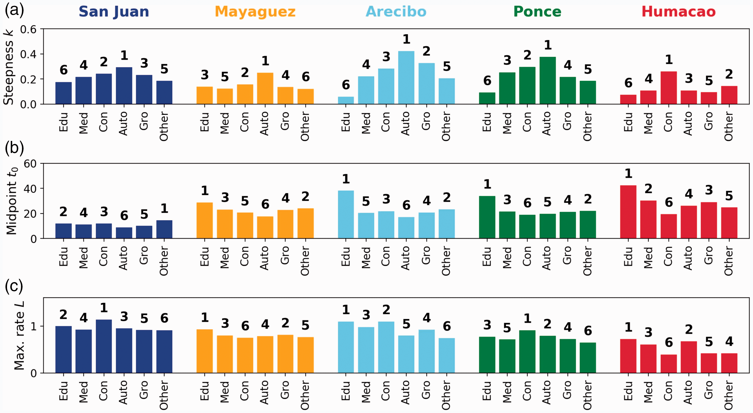
Inter-regional and inter-POI heterogeneity in recovery speed of visits to POIs in Puerto Rico after Hurricane Maria. Panels A, B, and C show the estimated parameters k, t0, and L of the logistic functions, respectively. Numbers (1–6) annotated above the bars show the rank among the six POI categories within each region.
The results observed from different data sources provide several insights on community recovery and resilience. They highlight the disproportionate effects of the hurricane on different regions within the island of Puerto Rico both in terms of physical (through water service deficit) and social (through the recovery of various essential POI types) systems. We observe that San Juan, the capital city of Puerto Rico, recovers much faster than other regions both physically and socially, while Humacao and Mayaguez fail to recover back to their original states. In addition to such correlations, these relationships of recovery speed suggest the existence of interdependencies among the social and physical systems during the post-disaster recovery period. Further investigation into the recovery dynamics of coupled social and physical systems would be interesting for future research.
Resilience at the city-scale
Krueger et al. (2019a) presented water security-resilience analyses for seven large global cities (Melbourne, Australia; Berlin, Germany; Singapore; Amman, Jordan; Mexico City, Mexico; Chennai, India; Ulaan Batar, Mongolia), as diverse case studies, in a quantitative assessment of urban water security using a systems dynamic model developed by Klammler et al. (2018). Each city experiences a series of hypothetical stochastic external shocks of various magnitudes and frequencies, which leads to temporal variations in service deficits followed by recovery using adaptive capacity at the household and utility scales.
Based on their analyses, Krueger et al. (2019b) grouped these seven case-study cities into three broad groups. Melbourne, Berlin, and Singapore were classified as “water secure and resilient” cities because they have adequate resources to deal with short-term disturbances, meet the household demands, and have built ways to ensure water supply to meet urban demands. Two cities, Amman and Mexico City, were designated as “cities in transition,” trying to confront their rapidly growing demands, by investing in increased infrastructure and ensuring water supply. Chennai and Ulaan Batar were clustered as “water insecure and non-resilient” cities, are in a poverty trap, lacking in financial and technological resources to upgrade infrastructure or inadequate access to reliable water source. Chennai has had problems meeting the demands and resorted to tanker delivery of water rather than supply through inadequate infrastructure. In Ulaan Batar, growing population in the Ger District, surrounding the central city, does not have adequate infrastructure (water, sanitation, and roads), with about 15 liters per day per capita (lpdc), compared to about 150 lpdc in EU and about 400 lpdc in U.S. Strong, nonlinear coupling between the technical system (water sources, treatment, and distribution) and management (utility) in both Chennai and Ulaan Batar suggests that recovery from deficits would be slow and, over the longer-term cumulative impacts of several shocks, might easily lead to collapse.
Discussion
“Resilience” is the collective ability of urban communities and utilities to minimize the adverse impacts of chronic failures/deficits and to recover from significant losses experienced after a disaster event (e.g., hurricane, or floods, or droughts, or earthquakes) (Krueger et al., 2020). Thus, households, utilities, and governments draw on internal and external political, social, technical, and natural resources, at larger spatial and temporal scales, impacting regional and global sustainability (see Krueger et al. (2020)), which is often unrecognized or unacknowledged in local-scale optimization. Krueger et al. (2020) argue for and illustrate the need for balancing these three elements in recovery efforts. Such optimal and balanced strategies are consistent with UN SDGs and are broadly applicable to other critical services such as sanitation, energy, food, and health. These three elements—security, resilience, and sustainability—are essential in seeking solutions to urban water supply/deficits in critical services, but not exceed either the “desirable” or “viable” operating spaces (see Krueger et al. (2020)).
Cities across the world implement various short- and long-term strategies to achieve security, while others consider resilience, and still others have a more expansive strategy to include relevant SDGs. This is evident in their temporal trajectories in confronting and solving multitude inter-related urban issues they face. Regional variability emerges depending on various socio-economic features and urban scales. Cross-scale linkages and feedbacks in adaptive and coupled complex systems are also important for emergence of resilience across system hierarchies; this concept of panarchy is well known in socio-ecological systems (Holling, 2001) and other systems including socio-technological systems in cities (Pescaroli and Alexander, 2016).
As shown in the previous section, our analyses using mobile phone data illuminate the regional heterogeneity in recovery rates as well as the sequencing of recovery of different POI types, which inform how the residents in each region coped with the disaster. Further analysis using data collected from alternative sources including social media platforms (Eyre et al., 2020), official reports, and household surveys could provide a more in-depth analysis of how people coped with the disaster. For example, Roque et al. (2020) used survey data to examine how self-organized community efforts were essential for two small barrios (Corcovada, Anasco; Mariana, Humcao) in Puerto Rico to rebuild failed infrastructure and restore critical services. They were effective in using existing social networks at the local level, forge new connections to other faith-based and NGO groups, and also marshal much-needed resources from diverse organizations and agencies from distant locations. Such integration of data for quantitatively understanding social dynamics of recovery would be an interesting topic for future studies.
Implications for urban resilience
Social and physical system interdependencies
The City Resilience Index (2014) further states that enhancing urban resilience requires “… making people, communities, and systems better prepared to withstand catastrophic events—both natural and man-made—and able to bounce back more quickly, and emerge stronger from these shocks and stresses.” Thus, urban resilience is a long-term process, where urban communities, managers of infrastructure, and governance systems continuously learn and adapt to rebuild and improve. This requires efforts between the communities and the governance hierarchies to communicate, coordinate, and collaborate; that is, urban complex systems are managed as socio-economic systems coupled with physical infrastructure systems and assets to build disaster resilience. In this study, we examined such interdependence at city and regional scales in several case studies.
We examined the recovery dynamics after hurricanes in various regions incorporating large and small urban settlements, using empirical data collected from Puerto Rico during Hurricanes Irma and Maria, as well as case studies on multiple large cities around the world from previous work. We build on earlier synthesis efforts and case study analyses which examined specific interdependent engineered urban networks providing critical services and socio-economic consequences urban inequality. Our analyses of water security/resilience in several global cities and five regions in Puerto Rico reveal interdependencies between physical-engineered and socio-economic systems and the need for balancing security, resilience, and sustainability as the three key elements essential for achieving SDGs.
Intra- and inter-city inequalities
Inequalities within and among cities and regions in their adaptive capacity in mobilizing needed financial, managerial, and technical resources has a significant impact on disaster preparedness and recovery. In developing and poor countries and regions, residents in large metropolitan regions cope with chronic deficit in multiple critical services and are vulnerable to collapse during disasters. The rate of recovery for these communities is slow prolonging their suffering. Our findings from city-scale and regional analyses of urban water security/resilience serve as archetype case studies and provide guidance for other cities and regions.
Disaster recovery efforts often focus on building back infrastructure services to pre-disaster conditions, perhaps even more robust than before, to decrease vulnerability. To do so would be a missed opportunity to “build back better” (Johnson and Olshansky, 2016; Wilkinson et al., 2018). Such strategies include improved preparedness, innovations in rebuilding (e.g., decentralized) infrastructure (Roefs et al., 2017), empowering local organizations (Collodi et al., 2019; Pyles et al., 2018; Roque et al., 2020; Wilkinson et al., 2018), and various other ways to amplify existing social connectivity and adaptive capacity.
In poor and developing countries, cities experiencing rapid population growth, existing infrastructure systems, and governance agencies are overwhelmed by increasing demands and lack of required financial and technological resources to maintain and build required infrastructure. Communities living in informal settlements (20–30% of urban population) are not connected to centralized infrastructure and/or to governance institutions. These communities do not receive adequate critical services and cope with chronic shortages. These communities are further marginalized by not having a political “voice” and participation in management and decision processes. Thus, they are highly vulnerable to extreme events, pay a disproportionate cost of disruptions, and recover much slower than rest of the urban community. As a result, these poor communities in large cities suffer first, recover last, and remain in precarious and insecure state (Krueger et al., 2019b).
Evacuation and recovery are significantly impaired in such cities. A spectrum of solutions proposed range from (1) extending the centralized infrastructure to informal settlements, (2) decentralized and customized solutions to provide local-scale nature-based solutions, and (3) engaging all communities in decision-making.
Resilience of SIDS
According to United Nations Conference on Environment and Development (UNCED), SIDS are vulnerable to large-scale disasters “because of their small size, limited resources, geographic dispersion and isolation from markets, place them at a disadvantage economically and prevent economies of scale” (United Nations Department of Economic and Social Affairs, 2010). Low mean elevation on many SIDS increases the risk of flooding, erosion, and wind damage. Over the past 150 years, the Caribbean SIDS have experienced around 1000 Tropical Storms and 200 named Hurricanes (H2–H5). In addition, tsunamis, earthquakes, and storm surges cause significant damage to marine, coastal, and terrestrial ecosystems, all exacerbated by climate change threats.
Given low median income per capita and extreme socio-economic inequality, the populations are ill-equipped to cope with chronic disruptions—persistent water, food, socio-economic, and health insecurities. Nine of the 17 named storms brought tropical storm or hurricane winds to one or more Caribbean SIDS and 9 of the 29 Caribbean SIDS experienced landfall of at least one major hurricane. Thus, from disaster resilience and adaptive capacity perspectives, SIDS communities are in a “poverty trap,” unable to recover from frequent disasters. These problems are especially severe in Pacific SIDS, where median income per capita ranges from ∼US$1000 to ∼US$5000, contrasted to much higher average values in Caribbean SIDS (Perch et al., 2010). Since income is a key indicator of the quality or recovery, compared to our analysis of Puerto Rico’s damage recovery from Hurricanes Irma and Maria, the Caribbean SIDS might be even less resilient than the four smaller regions (excluding San Juan).
Rebuilding damaged infrastructure and housing with significant international aid is a necessary short-term strategy but an inappropriate solution for the long term to enhance SIDS community resilience. Loss of critical infrastructure during disasters provides an opportunity to “build-back better” not just to rebuild infrastructure that might fail again. Learning from experience and transformation(s) to minimize failure risks are essential elements of resilience. Disaster resilience issues that we have addressed for Caribbean SIDS also have parallels in Pacific Island Communities (PICs) (Sanderson and Bruce, 2020; Sanderson et al., 2016). Rapid urban population growth fueled by rural–urban population migration increases population density and unregulated growth of informal settlements. These communities face urban flooding (exacerbated by inadequate drainage infrastructure), tropical cyclones, and multiple shortages of critical services and associated chronic insecurities. Thus, these PICS are also in a “poverty trap” in terms of security, resilience, and sustainability, all exacerbated by natural and man-made disasters. Although it may take decades to escape from the poverty trap, enhancing social capital (Aldrich, 2012) and leveraging community ties could pave a path toward a decentralized, sustainable, and resilient urban systems.
Footnotes
Acknowledgements
We thank Safegraph Inc. for providing the mobile phone GPS data used in this study.
Declaration of conflicting interests
The author(s) declared no potential conflicts of interest with respect to the research, authorship, and/or publication of this article.
Funding
The author(s) disclosed receipt of the following financial support for the research, authorship, and/or publication of this article: Purdue Systems Collaboratory, NSF Grant No. 1638311 CRISP Type 2/Collaborative Research: Critical Transitions in the Resilience and Recovery of Interdependent Social and Physical Networks, and Lee A. Rieth Endowment in Lyles School of Civil Engineering.