
Abstract
There has been a recent shift in England towards empowering citizens to shape their neighbourhoods. However, current methods of participation are unsuitable or unwieldy for many people. In this paper, we report on ChangeExplorer, a smart watch application to support citizen feedback, to investigate the extent to which digital wearables can address barriers to participation in planning. The research contributes to both technology-mediated citizen involvement and urban planning participation methods. The app leverages in-situ, quick interactions encouraging citizens to reflect and comment on their environment. Taking a case study approach, the paper discusses the design and deployment of the app in a local planning authority through interviews with 19 citizens and three professional planners. The paper discusses the potential of the ChangeExplorer app to address more conceptual issues, and concludes by assessing the degree to which the technology raises awareness of urban change and whether it could serve as a gateway to more meaningful participatory methods.
Keywords
Introduction
Urban planning is the discipline that attempts to manage and determine competing uses for land (Cullingworth and Nadin, 2002). Planning in England has two distinct roles; the first is to create policy, and the second is to make decisions based on this policy. Within both of these roles there are opportunities for citizen participation, although this is limited and narrower at later stages (Baker et al., 2007). It is widely accepted that citizens should have more say in shaping local areas, an agenda developed academically for over 30 years through the zeitgeist of the communicative and collaborative planning theories (e.g. Forester, 1982; Healey, 1997). However, although the sentiments of enhanced planning participatory forms are often agreed upon, the translation of the principles into established political and professional practices is much more difficult to achieve (see, for example, Sager, 2013; Tewdwr-Jones and Allmendinger, 1998). Nevertheless, generating the means to create a louder and stronger citizen voice in planning can serve several objectives by creating: a say in how neighbourhoods change (Baker et al., 2007; Conroy and Evans-Cowley, 2006; Evans-Cowley and Hollander, 2010; Le Dantec et al., 2015); an important role in knowledge exchange (Chandler, 2001); and a voice in the future of localities (Baker et al., 2007).
Planning in England has changed over the last few years as a consequence of the Localism Act 2011, with the introduction of neighbourhood planning and neighbourhood forums comprising of citizens, which “sets out a series of measures with the potential to achieve a substantial and lasting shift in power away from central government and towards local people” 1 (Department for Communities and Local Government, 2011: 1). The impacts of this shift for community governance, planning systems and professionals are still being identified (see, for example, Clarke and Cochrane, 2013; Clifford and Tewdwr-Jones, 2013; Holman and Rydin, 2013). Although these legislative changes are intended to give citizens increased power in shaping their neighbourhoods, there is also an associated need to increase citizens’ understanding of and engagement with the planning system to enable them to have a relevant say in their neighbourhood’s future (Baker et al., 2007). Within neighbourhood planning and formal local planning practices, early and enhanced participation within the planning system relies on citizens being aware of which issues they can get involved in, when, how, and where. Involvement at earlier stages of planning can have an impact on how places develop, rather than at a later stage, when there is usually only room for minor alterations to individual schemes that have been negotiated between local planning authorities (LPAs) and developers.
Although there are many benefits to securing enhanced public participation in planning, it has often been either difficult to achieve or has remained relatively low (Holman and Rydin, 2013). The statutory defined parameters and rigid language have been identified as reasons for a reluctance for the public to get involved in planning (Conroy and Evans-Cowley, 2006); only a small proportion of the public actively engage with the planning system, a factor that has not changed significantly over many decades (Fagence, 1977) and remains a problem even since the introduction of neighbourhood planning (Parker et al., 2014). The bulk of planning participation methods to date have been non-digital, often termed “traditional” (Evans-Cowley and Hollander, 2010), despite widespread recognition over the last ten years of the opportunities for more citizens to become engaged in the planning system by embracing technology (for meaningful participation) (Le Dantec et al., 2015).
In this paper, we outline a case study research project set within a local area of England that applied a new digital application (an “app”) called “ChangeExplorer” designed by the authors for a local planning practice setting. The aim of this research was to assess the opportunities and identify the barriers of introducing more technological methods, especially wearable devices, to planning participation. A critical objective was to identify whether digital technology could encourage more involvement in planning on the terms of citizens as digital users. The research was undertaken using three methods: the development of a smart watch app with opportunities for citizen participation in the local planning process; the deployment and empirical study investigating its value in planning participation; and the design implications for in-situ interactions on pervasive devices and technology-mediated planning participation. Nineteen citizens and three professional planners were asked to pilot the app and to provide feedback on their experiences. The paper goes on to review more conceptual issues by critiquing the role of technology and participation.
Planning using digital opportunities
In England, LPAs are legally obliged to notify “affected individuals” of new planning policies within development plans and of planning applications. It is a matter of judgement of the professional planner on which members of the public should be notified based on a test of reasonableness. But as research has shown previously, the LPA’s notification of proposed planning changes are often couched in technical and legalistic language which can be difficult for non-planners to understand, and responding to these formal notices requires significant effort (Baker et al., 2007). Movements towards technology-mediated participation have tried to address these difficulties, but progress has been slow (Gordon et al., 2011).
Currently, digital platforms designed for participation in planning mirror traditional methods rather than leveraging the opportunities technology offers, and rarely go beyond a one-way provision of information. These deficits have prompted calls for “lunchtime participation” (Conroy and Evans-Cowley, 2008), allowing people to informally participate without having to resort to utilising formal processes and legalistic language. In addition, there are opportunities for technology to help address the difficulties raised in planning participation. Other work has looked at how using social media, data mining and social listening allow for personalised content and public engagement (Bennett and Segerberg, 2012) or for communities to self-organise following crisis (Starbird and Palen, 2011). Embracing digital technology as a means by which citizens can more readily understand planning and raise awareness of the opportunities for involvement contributes to the removal of barriers to citizen engagement in the planning process, and thereby allows a more accessible method for the public to potentially shape their neighbourhood’s future.
Digital systems for urban planning sit at the interface of human computer interaction (HCI) and democratic opportunities for citizen engagement, resting on issues concerning place, politics and communication. Many digital systems have been developed over the last ten years that have proved to be popular with citizens and it is worth reviewing the experience of some of these to date.
Bugs et al. (2010) list four principal categories for technology-mediated participatory urban planning practices; information distribution, transparency, solutions through participation, and consensus building. Through the discussion of case studies, this paper will go on to consider the degree to which previous or existing technologies have allowed for the increased role of the citizen in planning.
Information distribution and transparency
The first and third principles Bugs et al. (2010) propose examines how information is distributed. In the following case studies, the role of citizen-created information in either supporting in-place voting (Vlachokyriakos et al., 2014) or through pervasive technologies augmented the physical world with geo-spatial data (Bilandzic and Foth, 2012).
The PosterVote project (Vlachokyriakos et al., 2014) demonstrated the potential for engaging citizens in quick, lightweight, and situated interactions using data as a tool for activism and allowing communities to collect and share their own information, rather than relying on data received from their local council. The low-cost electronics and traditional paper poster allowed people to vote in polls, and later discuss the data on an online forum. The purpose of the electronic poster was not to gather evidence of support (votes) but rather to build discussion around their choices. The role of false and repeated votes was discussed by the authors, but they emphasise that the poster’s aim to generate discussion and debate, rather than replace established e-voting systems.
The use of pervasive technologies was investigated to enhance the role of the citizen in planning by Bilandzic and Foth (2012). They see an opportunity in locative media (media bound to a location) to allow a layer on top of the physical world, “augment[ing] people’s experiences in real places through relevant geo-tagged information” (Bilandzic and Foth, 2012: 66). They note the importance of not distracting the user from their immediate physical environment, but “evolve[ing] from people’s natural practices, tasks and activities and, in particular, from the meaning that they attach to those” (Bilandzic and Foth, 2012: 68). Other work (Bilandzic and Foth, 2012; Hamilton, 2009) argues for context awareness and locative media to be used to supplement, not remove, a user from their environment. They highlight the advantages of information that is in-situ, related to the place the user is in, giving places an identity away from the “non-space of the Internet” (Hamilton, 2009: 394).
The work demonstrates the ability of situated technologies to promote civic participation through interactions that are attached to a location. There are, however, challenges, such as the provision of accurate and timely information, and the results of technologies affecting real-world changes (Al-Kodmany, 2001; Hu et al., 2016). Technologies that promote discussion and debate show the potential for technology in giving additional opportunities for civic participation, but these technologies do not fall outside the existing public/planner dynamics of enhancing the role of the citizen (Sager, 2013; Tewdwr-Jones and Allmendinger, 1998). Rather than replacing current and more involved methods of participation, they should allow additional opportunities for awareness raising, information sharing and participation.
Solutions through participation
Bugs et al. (2010) note that technologies which facilitate participation through mapping tools could aid planners in understanding the challenges that citizens are having in their built environment.
FixMyStreet, for example, is a smart phone and web-based problem reporting platform used by citizens to make local authorities aware of place-based issues, such as highway potholes (MySociety, 2015). Research on the platform has identified issues around expectation setting and a related lack of recognition of user-generated content (King and Brown, 2007), but with 16,000+ reports to 430 councils (MySociety, 2015), the platform demonstrates the effectiveness of allowing people digitally to quickly report problems.
In a similar vein, Le Dantec et al. (2015) explored the use of mobile technology through using crowdsourced data collected from a smartphone app (named Cycle Atlanta), used to generate discussion at a charrette (a public meeting held with the aim to solve a problem). The app reduced technocratic paths, allowing citizens to report problems without having to educate themselves on the organisational structure of their local council.
In the project, two datasets were presented at a charrette with both cyclists’ routes and their opinions. The project raised concerns about how these alternative methods of participation can be interpreted and integrated into traditional policy development and decision-making practices. It demonstrated the power of “objective” data in leading a “subjective” discussion, by using data to guide discussion around lived problems and identify potential solutions. The platform proved useful in promoting discussion around solutions, rather than using them instrumentally as a tool to gather data and intelligence.
Although these systems can aid civic participation, they may also exacerbate already existing digital and representation divides during decision-making processes. The experience suggests that technologists and planners need to ensure that future methods of participation allow for representative participation through a suite of methods; digital technologies in themselves should not be viewed as a single solution.
Consensus building
The final principle Bugs et al. (2010) argue for is using participatory technology to build consensus, and to facilitate two-way discussions between planners and citizens.
One such digital system was developed by Nuojua (2009). The system utilises a map-based web application for participation; users comment on places online, with the option to attach photographs to their comments. Although the system generated a lot of interest, they found that the comments left in the locations were too general to be used during the creation of planning policy (Nuojua, 2009). Whilst these are wider issues within public participation, it suggests an appetite for the public to discuss issues openly, rather than channelling towards a particular planning document or site. A similar approach had been developed in research by Rinner et al. (2008) that linked a discussion forum to a map display to facilitate geo-referenced communication.
Furthering the role of consensus building and open discussion online, Crivellaro et al. (2014) discussed how citizens gather online, in this case Facebook, around a local social movement. It documented the process of forming a like-minded community, but identified a struggle in translating these emotions to decision-makers. Further work encouraged participants to engage with issues and the future of their public spaces through locative archival material, revealing issues and eliciting debate (Crivellaro et al., 2015). The findings demonstrate how technologies can facilitate discussion that is planning-related but identify a difficulty in turning this discussion into actionable policies which easily fit into traditional modes of participation. Whilst these provide an opportunity for technologies which aid citizens in easier participation, technologies must also be developed which provide actionable intelligence that can be translated into change.
Participation through technology
This review of recent related digital systems has identified a tension between allowing people to use platforms they are already registered on, and using technologies preferred by the planning professionals. Previous work has tackled this with mixed success. There is a translation issue here: integrating newer participatory mechanisms into an existing planning system which tends to favour tried, tested and legislated methods. Technological applications, if they are going to be successful, must therefore walk a fine line between being fluid and engaging, and fitting within decision-making mechanisms that are often more static.
Alongside this there are many criticisms of the increased role of technology in the planning processes, sitting within an intertwinement of a movement towards smart cities and austerity. For example, Lowndes and Gardner (2016) see the increased role of technology in planning as a means to justifying the cutting of local public services and front line staff. It is fitting at this point to state the authors’ intentions; whilst we understand that this study could be used to further public sector cuts and reduce opportunities for traditional participation modes, we use this research study to advance additional methods of participation that enhance the role of the citizen, supporting the role of the wider public good in planning, rather than acting as a replacement.
Shaping the design
Technological requirements
The previous section has discussed the varying degrees of success of enhancing community voices in governance by using technologies to allow easier participation in the planning process. What is often missing in the design of digital technologies is for the voices to be captured in a way that is actionable by decision-makers, whilst also being user-friendly and easily understood.
Several authors have discussed the design requirements of technology to support workable and practicable implementations that are worth considering as facilitation mechanisms. Previous studies (Baker et al., 2007; Conroy and Evans-Cowley, 2006) suggest that traditional methods of planning fail to make citizens aware of opportunities for involvement. Haklay and Tobón (2010) has also discussed the requirement to understand the abilities of non-expert users. Developments in technology allow for its use outside the typical setting of a computer; in the wild, in-situ interactions are a potential solution, where citizens would not have to deal with the complexities associated with geographic information systems (GIS) by allowing citizens to be physically located in the place they are commenting on at the time. There are additional opportunities which allow the user to remain and reflect upon their current environment, and quickly convey these (Hamilton, 2009). Furthermore, building discussions around the notion of place, rather than planning, may provide a context more familiar to citizens.
Finally, there is an opportunity to create a platform that allows for ongoing engagement, rather than a process that favours selective consultation opportunities. We argue for a shift towards participation that is based around an ongoing discussion around where people live, rather than conversations solely when planning policy is undergoing consultation. On this basis, the overriding aim should be to achieve an open, up-stream discussion where the public shape the ideas for discussion at an early stage. The purpose of this research, therefore, was to create a platform which recognised the experiences of people that live within a city, as emphasised by, for example, Healey (1997) and Sandercock (2003); that does not suggest that the solution is technology alone, but that an alternative method could be built for people to discuss their feelings and aspirations towards place. Twentieth century planning is failing to see cities as living places of work and as homes, of interactions and of communication, because during the twentieth century planning turned its back on questions of values, of meaning, and of the art, rather than science of city building. (Sandercock, 2003: 221)
Change Explorer
There has been a recent growth in wearables, with 102.2 million sold worldwide in 2016 alone (IDC Research Inc, 2016). Their advantages include their portability, context awareness, and easier readability and fewer missed notifications than smart phones (Rawassizadeh et al., 2014). They do, however, have challenges, such as their small screen, lack of input devices and short battery life (Raghunath and Narayanaswami, 2002; Rawassizadeh et al., 2014).
Category choices made by users through the app.
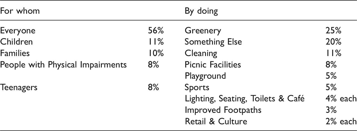
Source: Authors.
Submissions made through ChangeExplorer on both changes citizens would like to make, and who they would make them for.
ChangeExplorer was designed to be used in two ways; first, by receiving a notification informing the user when they have entered an area within which a change was proposed, and secondly by opening the app when located in an area someone chose to comment on. The App is shown in Figure 1. Users were made aware of notifications through sound and/or haptic feedback (similar to a vibration) from the watch. When their wrist was raised, dialogue informed the user that they had entered an area on which the LPA would like to engage citizens with, with the option to either respond to or dismiss the notification, or not receive future notifications. The notification contained an easily identifiable ChangeExplorer icon (see Figure 1), allowing users to quickly understand that the app was seeking their comments.
Details of ChangeExplorer’s client server architecture and screen shots of the watch’s interface; screen shots of the notification being received, the app on home screen, and the process of leaving feedback and confirmation.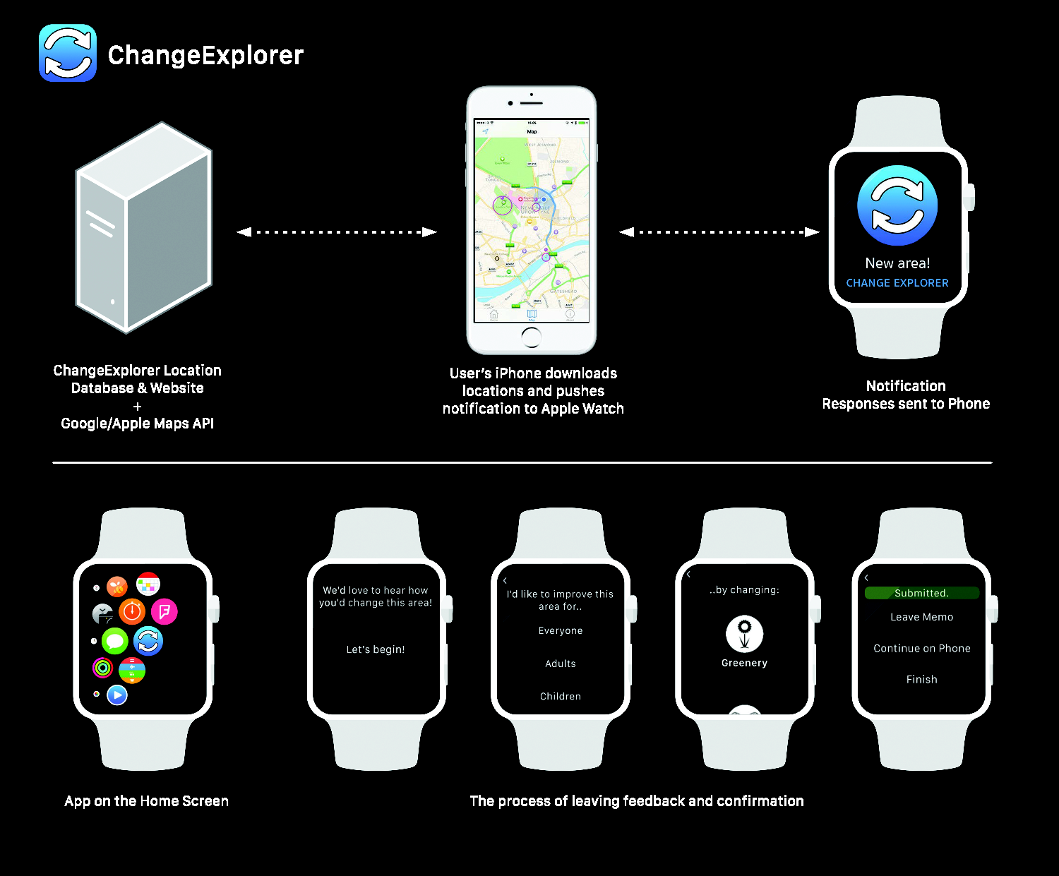
The design for ChangeExplorer was informed through previous literature and case studies, and the authors’ aim to make a technology that allowed potentially complex changes to the built environment to be explained to the participants quickly when in the area of the proposed change. ChangeExplorer met the technological requirements in four ways. First, the notifications and interactions were simple and glanceable (Raghunath and Narayanaswami, 2002; Rawassizadeh et al., 2014), allowing the selection of categories for speedier responses, with the option to add further comments if the user wished to. Secondly, there was no need for the user to understand the structure of their local council (Le Dantec et al., 2015), or learn the use of a GIS system (Haklay and Tobón, 2010). Thirdly, to avoid a problem with comments being too general (Nuojua, 2009) ChangeExplorer used categories to guide the user to planning related comments; this also allowed easier sorting of comments after they were made. Fourthly, it allowed the user to reflect and comment on their built environment whilst they were physically within it (Vlachokyriakos et al., 2014).
The Apple Watch was chosen due to its ability to provide notifications to the user quickly, and its simple user-interface. The watch also challenged the authors to design a technology that allowed for these quick interactions. The app aimed to seek views that could feed into earlier stages of policy development, so the questions were targeted towards aspirational visions for the area, rather than comments on individual elements of any proposed scheme.
A phone app sat alongside the watch version. This had two functions: first, to allow more detailed comments to be submitted, and secondly to find places that were identified as changing. The phone app complemented the functionality of the watch app, rather than duplicate the functions. The Apple Watch remained the App’s primary interface, but the phone’s larger screen was suited for continuing comments with additional text. The app received locations from a server, which also served a website enabling the creation of areas and viewing of comments.
Testing and evaluation
The pilot evaluation used a case study to assess the effectiveness of the app. This was within North Tyneside Council (NTC), a LPA in a coastal area in the North East of England. The area had been popular with tourists previously, but over the past few decades has seen a decline in visitor numbers, leading to the seafront area falling into disrepair. In 2015, NTC approved plans for a £36 million regeneration scheme, aiming to improve the public realm along the seafront, and, at the core of it, a site known as The Spanish Quarter. Officials from the Council suggested using the pilot project as both a method of collecting views of citizens within the area and to evaluate the ChangeExplorer app.
The pilot research took place over four months in 2015 and included 19 participants (9 male, 10 female) aged between 14 and 50 years old with a mean of 25 years old, with most of them living in North Tyneside. Participants were given Apple Watches to wear by the research team during the pilot period and the average length of time for the deployments was 10 days (187 days of usage in total). Aliases have been used and personally identifiable information removed to maintain the participants’ anonymity. Participants were recruited through NTC’s youth participation and engagement team. Participants were not compensated for taking part in the study and all watches were returned at the end of the pilot. Ethical approval had been obtained prior to commencing the research.
None of the participants were previous owners of an Apple Watch. After the app was installed on their iPhones, it was paired with the Apple Watch they were provided with. They were given a quick demonstration, showing general usage of the watch and how to leave comments, and told what to expect whilst taking part in the evaluation. They were asked to wear the watch during their day-to-day activities, and leave comments should they want to. Participants were informed of their right to withdraw from the study at any time and the policies for protecting their data and identity.
Alongside the nineteen citizen participants, three professional planners were recruited for the evaluation to assess the suitability of the citizen comments for practicing planners. The planners were employed within the case study LPA and two neighbouring areas and reviewed all the data collected through the pilot app.
Data methods and collection
The research used two data sources to understand how the app was used: interviews and the comments made through the app. The interviews explored how citizen participants understood and interacted with the watch, and whether they felt they could represent their views. The planners were also interviewed, who after viewing and exploring the comments made by the participants, discussed how the app could be used during their practice. Each interview lasted approximately thirty minutes, and took place in a café within NTC’s offices; they were recorded and transcribed verbatim.
The interviews and comments were analysed separately using thematic analysis outlined in Braun and Clarke (2006). The themes were semantic-based, with inductive thematic analysis used to generate themes from the data. The app data were separately thematically analysed for the research findings, rather than for sharing the app’s comments with the planners.
Research findings
Citizen responses
This section discusses the findings of the deployments, both from the app and from the interviews, with both citizens and planners. During the app’s use by 19 citizens, 124 comments were made, averaging almost 7 comments per participant. In addition to selecting categories, 29 of the comments included text, averaging 12 words per comment. During the study, 17 geographical points were identified by NTC where changes were being considered. Forty two (34%) of the comments were made because of a notification on the user’s watch and made at a point identified by the council. Eighty two (66%) comments were made without a notification, but rather by the user opening the app on their own accord.
Table 1 shows the categories of the improvements selected by respondents. It shows most used the “Everyone” category – suggesting a view that the public realm should be easily accessible to all. Among the others, there was a relatively even spread of category choice, demonstrating the variety of public realm improvements participants wanted to communicate, and a feeling that their comments were not shaped by the pre-selected options available. The text comments usually either expanded the selected category choice, such as the specific type of improvement, or provided a brief statement discussing another matter if the respondent had chosen “other”.
Many participants spoke of being able to view notifications and leave comments quickly before leaving an area, and stated that it allowed them to understand when they entered an area where the council were seeking comments and make their comments in-place. Participants spoke of the advantages of being able to see the notification quickly and decide if they wanted to leave a comment in that moment; interviewees stated; “[the watch] brought it to your attention, whereas your phone buzzing in your pocket you think ‘oh, I’ll sort that out later’” (Daniel), illustrating the advantages of the watch. They discussed, when they are “out and about” (Jessica), the ability to be notified of when they had entered an area. There was positive discussion around being able to leave thoughts about an area quickly, thereby giving it an advantage over other forms of planning participation. These findings corroborate other work (Raghunath and Narayanaswami, 2002; Rawassizadeh et al., 2014), and offer an insight into how planning participation can leverage quick interactions and notifications to prompt people to think about their neighbourhoods. The intention of the platform was to allow for open-ended dialogues around place, rather than one with strict parameters; aiming to get away from a planner’s pre-conceived ideas of what the conversation should be about. The categories aided the sorting of these comments into different discussions that were taking place.
When giving comments, most of the participants stated that the categories for choosing the improvement were suitable to the changes they wanted to communicate, further demonstrated by only 20% of comments being “something else” (Table 1). When expanding upon their comment, typing into the phone proved the most popular, with Fred stating: “it’s just more easy to type … you could just say whatever you wanted which was quite good”. This suggests that although the comments were suitable, many felt they needed to expand on their comments and provide more than just selecting a category, and appreciated the freedom allowed by typing in their responses without having to address their opinions formally in a letter or email – the traditional means to communicate comments. This indicates the importance of participation that takes place in-situ with lower barriers than traditional methods.
One tension that emerged from the findings was around the balancing of speed and responsiveness with a desire to leave expansive comments. Participants expressed a desire to give more information on their thoughts, by expanding on their category selection. For example, some saw photography as a way of effectively communicating their ideas; “if you were able to take a picture of what it looks like now, and then do a quick sketch of what you think it should look like, I think that’d be really good” (Peter). This suggests a desire for fuller-participation but still within the app, and instead of receiving a notification and responding to it in-situ, they suggested expanding on their comment after returning home. Participants stated that they would be willing to discuss their views in more detail by attending meetings or writing letters to decision-makers. Some respondents expressed an interest in having more discussion about places: “You give feedback, and it’s not a discussion … we can’t just get rid of things, but we can have a discussion about it, saying actually ‘What could we do here?’” (Harry). This creates a tension in either having a bounded, limited app for quick interactions and low-friction participation, or increasing the burden on users to submit a comment, with a need to create an app that can no longer be used easily in-situ, but one that would encourage more involved discussion.
The study found that participants also wanted more information on the areas than the app provided, stating that they would like to receive information on the exact changes that were proposed and when it would be likely to happen. Jack commented: “it was restrictive in terms of the length and the detail that [it goes] into … and that kind of nuance you completely lose because of the restrictions of the device”; Sophie indicated she would like “a little bit more information”. This lack of information often manifested itself in participants focusing their comments towards problem reporting (reporting issues that are easily resolved), rather than shaping a future vision for the area.
When prompted about this during interviews, participants stated that the notifications encouraged them to immediately reflect on the areas, and that it was usually a maintenance issue that was immediately obvious. However, without a notification being received, participants gave visions of what they would like to see, often drawing comparisons to other areas, for example, “we should have a park like x does”. Many participants saw the app as a way of evidence gathering around issues, and requests for being able to submit photographs to document these problems. For example, Jessica stated: “I would definitely take photographs if I had seen something that was bad – or needed change”, and Fred: “instead of typing ‘someone graffitied on a wall’, you could take a picture”. Photography for aiding participation was shown to be effective by Al-Kodmany (1999), where photo-realistic images were used to communicate and critique changes, however, demonstrated issues with the time and expertise resources required to make these.
The quick interactions may have led to people feeling they could not sufficiently express their vision for the area and, instead, opted for improvements that were easier to communicate, with a simple “that’s fixed” solution. Similar observations were made by Vlachokyriakos et al. (2014), where the voting device was not able to capture the richer discussions that took place around the vote. The quick interactions may have encouraged an equally quick reflection, with participants submitting the first thing that was obvious. Yet participants also valued the notifications for motivating them to think critically about the area they were in at that moment, and imagining the future of an area. They saw value in being prompted to think about the area: “It pushes you a bit. I think it’s useful to try and force opinion out of someone – just say I’m walking through a new area, hardly been there before, and you think, if I was to come back here, I’d like that” (Peter).
Several noted themselves reflecting on their environment more frequently, regardless of if they submitted a comment: “it kind of made you think about the local area more” (Fred), and “when it pops up, you probably have more of a think about … the area that you’re stood in, so, yeah I was quite aware of noticing things” (Jessica). Vicky discussed this whilst being driven through North Tyneside and receiving a notification prompting for her views: “It was weird – you do start getting more interested and more aware of what’s around you. Because when I was driving through North Tyneside I went past The Spanish Quarter and obviously I got a notification, and I was like ‘look, there’s something happening’ and I was looking but normally I just drive past and not even look”.
Participants stated that although a lot of the comments received through the app were problem reports, the app seemed to influence how participants experienced the areas. The interviews suggested that they saw their environment increasingly critically, noticing both problems they had not seen before and opportunities for improvements. Whilst ChangeExplorer could encourage the participants to reflect on their environment, it was not always able to capture these. It was thought that through quick and in-situ interactions, comments would be easier to communicate, but there is a balance to be struck between quick feedback, and time-consuming but often more detailed reflections; echoing the findings of Vlachokyriakos et al. (2014).
The planners’ perspectives
Interviews with the planners of North Tyneside and two neighbouring areas found interesting insights into how the app could be used within a local planning context. The planners considered that the citizens’ comments would be useful for those trying to understand the difficulties and changes a community would make to their neighbourhood at early stages of policy formation, and understanding how people use space. This would be particularly true during the evidence gathering stage (gathered to support planning policy during its writing) and when trying to understand how space is used: “As planners, we probably have trouble picking up the value feelings that people attach to particular places, or buildings, or parks … We have all the empirical stuff, whether the site floods, we can pick up a lot of that off data, but it’s how people feel about particular places” (Sheila).
It was suggested the comments would be useful for regeneration, with the aim of improving an area as compared to city-wide planning policy formulation, and saw the value of the technology allowing earlier engagement with the plan-making process. They stated that the comments would be used to get a grasp of problems being faced by an area and, in time, they would be looked at with the intention of integrating the evidence into planning policy, but raised a few potential issues with the use of technology and town planning. They discussed issues around verifying whether the comments were from residents of their area, so they could have “a foot at the table”, but that they “don’t necessarily see that as being a difficult exercise”. They also stated that the platform might not lead to immediate change that citizens might expect, stating: “we also need to be careful of the exceptions – we want to get information out quickly; people will naturally assume that our way of dealing with it is as rapid […], the whole business with technology, it’s great, but you know, people will basically demand a response there and then, and unfortunately […], it’s not that easy […]. It’s probably about an education role about how the process works and not unduly raising those exception levels”. These echo King and Brown’s (2007) findings with the users of FixMyStreet, where the expectations of a speedy resolution of a problem was not met.
The planners valued the longer, text comments more than the category selection. They did, however, suggest that more targeted questions and categories for selection around specific information they were trying to elicit would help make the short replies more valuable. They also suggested the platform could be used to signpost citizens to more traditional methods of participation, where they could ask for more detail on comments that citizens had previously made, stating: “this could almost sign post them […], so they can start to see immediately, or get home, and then be able to look into the detail”.
Conclusions
The deployments and subsequent interviews offer interesting insights into planning participation through smart watches and, more widely, implications for in-situ technology surrounding citizen engagement using pervasive devices. The findings are useful to inform planning participation methods and mobile planning participation.
The app led to participants thinking critically about the areas they inhabit and pass through. The notifications were an effective tool in encouraging participants to think about what they would like to change and for them to feel empowered in raising relevant issues. It allowed participants to know where and what they were making suggestions on, and when to give their comments, in the context of understanding their current location. The notifications and quick in-situ interactions allowed the app to address some of the issues with current planning participation methods. Allowing for lunchtime participation, which does not require a significant amount of time to undertake, is a significant move towards reducing barriers for participating (Baker et al., 2007; Conroy and Evans-Cowley, 2006). Reducing barriers to participation is one step in gathering the opinions of those that currently do not engage with the planning process, widely acknowledged to be important (Baker et al., 2007).
The app was effective at simplifying methods of participation but, sometimes, this over-simplification led to people simply reporting issues, rather than presenting a vision of the future. Problem reporting is potentially easier to resolve, but does not reach the goal of giving citizens an enhanced role in shaping the future of their area. The pilot study contributes to understanding the implications of mobile and wearable technologies to encourage greater reflection and participation in planning. It also demonstrates how these quick-interactions might be configured to make them useful to professional planners and decision-makers, and how in-situ comments can lead to a better understanding of what is being commented on, and a simplified method for sharing these comments.
There has been a tendency for planning participation methods to throw citizens in at the deep-end (Baker et al., 2007). Citizens are often required to understand legalistic language, read long documents, or travel to meetings to have their voices heard (Baker et al., 2007; Conroy and Evans-Cowley, 2006); they are asked to comment on policy documents that are usually phrased differently to how they experience their everyday life. The app, being location-based, helped overcome some of these issues. ChangeExplorer addressed some of the barriers discussed elsewhere (Baker et al., 2007; Conroy and Evans-Cowley, 2006; Gordon et al., 2011), by lowering barriers to participation. Once citizens had thought, reflected, and recognised what (they perceived as) needing improvement, they stated a desire to take their comments further and engage more thoroughly in discussions.
Understanding the role of information and data provision and participation is still being explored in a movement towards our increasingly data and technology-filled cities (Townsend, 2013). What this research shows is that there is a balancing act between that of providing enough information to allow informed judgements, and information that is easily understood, which ChangeExplorer probes. What this information was shown to do, however, was to engender an interest in finding out more, and sparking an interest in this kind of information.
There is a complicated space between selecting categories and communicating a vision. The research identified that whilst participants wanted both, they would be willing to engage with more in-depth planning participation methods if they felt strongly about something, after realising there were opportunities to have their voices heard. This suggests the need to develop a range of participation tools as a potential solution to both the lack of depth to quick-interactions and towards more engaged current planning participation methods.
The role of ChangeExplorer was also discussed by the practising planners, who stated that small pieces of information can be very useful during evidence gathering. ChangeExplorer demonstrated a purpose in these smaller pieces of data, that can aid planners in understanding how space is used and how citizens experience place.
Technology-mediated planning participation could embrace a gradient of planning participation. With this gradient, lightweight methods of planning participation is both an opportunity to provide information useful to planners and aid planning participation, and as a steppingstone into more engaged methods. Digital technologies can facilitate and encourage this escalation of involvement when it suits the citizen. Through developing and deploying ChangeExplorer, the pilot project has contributed to research on both wearable-mediated citizen participation and mobile participation fields.
Further work is required to see how such technology could be embedded within established local planning practices, such as how planners deal with the increased number of comments coming through such platforms, and how planners are held to account once these comments are made. Future projects should also explore the role of smart phone photography within planning; as a method of quickly communicating ideas and comments about the built environment. Developments in technology, such as increased smart phone battery capacity, and increasingly energy-efficient location technologies will also aid the take up of such technologies. The development of digital technologies within the planning system remains a fertile field.
Footnotes
Acknowledgements
The authors wish to acknowledge the support and assistance of North Tyneside Council and to those individuals who participated in the study.
Declaration of conflicting interests
The author(s) declared no potential conflicts of interest with respect to the research, authorship, and/or publication of this article.
Funding
The author(s) disclosed receipt of the following financial support for the research, authorship, and/or publication of this article: The research was undertaken as part of UK Research Council funded work through the EPSRC Digital Civics programme (Ref. EP/L016176/1), through the EPSRC Digital Economy Research Centre (Ref. EP/M023001/1), and through the RCUK/Innovate UK Newcastle City Futures Urban Living Partnership (Ref. EP/P00203X/1).