
Abstract
In Thailand, the majority of citizens primarily rely on private automobiles, as opposed to other environmentally friendly modes of transportation. This heavy reliance on driving has led to increased travel congestion and air pollution, therefore, it is crucial to adopt a comprehensive perspective on sustainability and mobility issues within the urban transport sector. This study selects the suburban area of Pathum Thani province as a case study to explore travel patterns. The rapid expansion of the community in this study area, driven by the development of mass transit, has led to significant growth in the surrounding region. Unfortunately, this expansion has occurred without comprehensive planning or a holistic view, negatively impacting the quality of life and livelihood of the people. This problem extends to the lack of a well-integrated multi-modal transportation system. This paper aims to compare travel patterns among various transportation modes, with a specific focus on the suburban area by conducting a questionnaire survey with 1,998 respondents residing in the study area. Integrated trip distribution, trip attraction, and physical building characteristics were utilized for spatial analysis to visualize and identify relationships among all associated factors. The results highlight obstacles on the path toward sustainable mobility while a significant level of auto-dependency persists, irrespective of the available transportation options. Ultimately, the analysis results contribute to the formulation of policy measures which aim to reconstruct the urban and mobility planning framework effectively, design appropriate policies, and create suitable mobility services to enhance the urban transportation system for sustainable urban mobility.
Introduction
In recent years, several cities have undertaken initiatives to restrict private vehicles’ access to city centers in a bid to enhance land use, street environments, and air quality, thereby advancing the cause of sustainable urban development (Cullinane & Cullinane, 2003; Kai et al., 2021). Mobility planning assumes a key role in not only improving the quality of life for urban populations but also serving as a vital tool for spatial planning and development (Burchell et al., 1997; Piorr et al., 2011). Mobility planning, however, remains a remarkable challenge, especially given the relentless pace of urbanization. According to United Nations projections, megacities are anticipated to accommodate over 750 million residents by 2030 (BCG, 2023). The rapid population growth, combined with the escalating prevalence of car ownership, has engendered a spectrum of issues, with traffic congestion standing out as a predominant concern. It is estimated that the global number of cars will rise from 1.1 billion in 2019 to 2.0 billion by 2040 (World Economic Forum, 2023). Traditionally, transportation has been recognized as a significant catalyst for urban sprawl (Jorge et al., 2017). The issues arising from urban sprawl are interconnected with aspects such as accessibility and urban dynamics, including the quality of transportation services, service coverage, and accessibility, among others (Church et al., 2000; Olvera et al., 2003). The dynamics of urban transportation have been influenced by a multitude of spatial and temporal factors, leading to consequences such as exponential population growth, rapid and unregulated expansion of urbanized areas, the deepening spatial segregation between residential, employment, and service areas, and an escalation in poverty levels.
Due to inadequate urban service provision, infrastructure deficits, and deregulation processes, there is potential for a disruptive impact on intra-urban accessibility, resulting in increased distances between workplaces and residences and heightened commuting costs, thereby affecting human activities (Holmgren, 2020; Tao et al., 2018; Wakabayashi, 1984). The activities and requirements of residents have the capacity to reshape urban system patterns, commonly referred to as “land use” (Godard & Diaz, 2000; Grieco et al., 1996; Turner & Kwakye, 1996). The concept of land use relates to human activities and the utilization of land, encapsulating economic and social activities within a specific geographical area (Leibowicz, 2020). As Mackett (1985) emphasized, the intricate relationship between transportation and land use is of paramount significance, given that a well-functioning, integrated land use and transport system is instrumental in enhancing competitiveness and facilitating sustainable mobility options for the entire community. The improvements made to the transport system have long-term implications for the spatial distribution of mobility and travel behaviors. Integrating land use and spatial planning can support the utilization of public transport while reducing car usage. The interaction between transport and land use is a defining characteristic of the built environment or urban land use, encompassing factors such as diversity, density, destination accessibility, street design, and proximity to transit. These elements collectively promote more favorable modes of active mobility through public transport-oriented development (Cervero & Kockelman, 1997; Fan & Khattak, 2008; Zhong & Bushell, 2017). The relationship between transport and human activity locations can be examined in terms of the land use and transport-integrated modeling, with a focus on prioritizing accessibility for walking and cycling within the transportation system. Accessibility to transportation has a direct impact on trip production, and the attractions in each area generate travel demand, ultimately leading to changes in travel patterns. Understanding users’ behavior is crucial in this context (Chang, 2006).
The discourse surrounding the integrated principles of mobility, land use, and urban planning commenced several decades ago; nonetheless, the majority of studies have predominantly concentrated on short-term effects (Haar, 1954; Katz & Rosen, 1987; Schwartz et al., 1981). It is imperative, however, to take into account the long-term consequences, as long-term and locational decisions wield a profound influence on transportation systems by shaping demand distribution and mode choices (Iacono et al., 2008; Waddell et al., 2003). Furthermore, peri-urban areas exhibit distinct characteristics in their internal and external structures, as well as in their relationships with neighboring regions (Aguilar et al., 2003). Nevertheless, the peri-urban context poses a significant challenge in the development of transportation systems, with a particular emphasis on the public transport system. The low ridership in these areas often renders many services financially unsustainable (Rodrigue, 2020). These regions pose significant challenges to our comprehension of mobility patterns, necessitating a push toward the promotion of more sustainable mobility options (Gallo & Marinelli, 2020; Iamtrakul & Chayphong, 2021).
This paper focuses on the analysis of travel patterns concerning both motorization and non-motorization choices, with a specific emphasis on the suburban area known as Pathum Thani province, selected as a case study. Initially, we conduct an overview of travel patterns across the entire suburban area to understand the nature of residents’ journeys and the time taken to complete them. Subsequently, our rational analysis involves the integration of trip distribution, trip attraction, and urban data pertaining to physical characteristics. This integrated data is then subjected to spatial analysis for visualization. Exploring the relationships among various factors allows us to uncover and demonstrate the resulting travel patterns. Understanding the current travel patterns within the existing transportation networks is vital for facilitating the effective improvement of the transportation system’s functionality and the integration of infrastructure. This, in turn, fosters the encouragement of users to choose alternatives to private vehicles.
Literature Review
The Influence of Mobility on Urban Form
The rapid urbanization process has led to many cities requiring holistic planning to address key urban issues, including traffic congestion, environmental problems, air pollution, and social exclusion. Consequently, there has been a renewed interest in exploring the connection between mobility and urban form (UN Habitat, 2023). The relationship between urban form and car dependency presents a significant obstacle to achieving sustainable mobility. Several studies have pointed to the association between mobility and urban form. For example, Miotti et al. (2023) found that urban form can influence travel demand. Cao et al. (2023) have explored the relationship between urban form, mobility, and social well-being. Pan et al. (2009) suggested that land use planning and urban design can effectively shape people’s mobility demand and travel behavior. Mäkinen et al. (2015) examined how urban form relates to the potential effects of transport policies on urban mobility transitions. Shaheen et al. (2021) emphasizes the impacts of shared mobility and urban form, particularly regarding peer-to-peer (P2P) car sharing. Their findings indicate that car sharing could be a significant strategy to reduce car ownership. Rodríguez De La Rosa et al. (2022) explore the relationship between urban form and mobility, with a particular focus on gender issues. They point out that urban sprawl increases mobility, especially for trips using private motorized modes. The several studies mentioned above highlight that there are various factors to consider when studying transportation mobility and urban form. Each city exhibits distinct developments in transportation systems, which are influenced by a wide range of urban forms and spatial structures (Rodrigue, 2020). In conclusion, urban form encompasses the physical characteristics of the built environment, including size, configuration, transport network, density, and more, all of which can impact travel behavior at different scales.
Urban Land Use and Mobility
The principle of sustainable mobility is fundamentally based on the seamless integration of land use and transportation systems (Loo & du Verle, 2017). With regard to land use planning within communities, neighborhoods, and cities, spatial planning should prioritize the efficient utilization of space to enhance vibrancy and accommodate the daily routines of commuters (Levinson, 1998). Achieving a balance in employment stimulation for both daytime and nighttime activities require the consideration of several elements within the built environment. This includes the creation of open spaces that serve as green pathways and provide shaded areas for traffic and relaxation. Numerous studies have explored the relationship between land use and mobility. For example, Meurs and Wee (2003) emphasize the formulation of policy recommendations related to land-use policies that can impact travel behavior. Gori et al. (2012) highlight the significance of activity density and the configuration of the transit network. Cavoli (2021) investigates the subject of sustainable mobility and land-use transitions, highlighting policy recommendations aimed at reducing car usage. Additionally, Nebel et al. (2021) examines ongoing land use changes and discusses the potential for more sustainable mobility patterns. In essence, urban land use mirrors the location and degree of spatial aggregation of various activity types within a typology of land use, whether formal or functional. These activities are closely linked to the transportation system as they support the transportation demands generated by activities within the area. Activities differing in function and activity density attract varying travel volumes to the area (Levinson, 1998).
Importance of Mobility for Peri-Urban Areas
When considering mobility in peri-urban areas, it is essential to understand the context of commuters’ travel patterns and tailor strategies to address specific degrees (Errington, 1994; Levinson, 1998). This integration necessitates careful consideration of peri-urban areas and the effects stemming from their “urbanization” spilling over into the surroundings. Mobility is a concept employed to describe the physical characteristics of a particular mode of transport as it relates to individual requirements in traversing a geographical distance from origin to destination. It involves several prerequisites, including not only the existence of transportation infrastructure, which is devoted from mobility, but also considerations of accessibility. Additionally, the means of transport and infrastructure used may vary from person to person (Bassand, 1985; Ikezoe et al., 2020). The prospects for an integrated public transport system should be contemplated, as it offers an opportunity to provide access to previously unreachable areas through the enablement of transport-oriented development, further enhancing coverage for daily commuters.
Methodology and Data Collection
Data Collection and Study Area
Pathum Thani province was selected as a representative suburban area due to the urbanization process in the capital city, which has resulted in congestion issues, poor accessibility, and compromised environmental quality. Pathum Thani province is an integral part of the Bangkok Metropolitan Region (BMR) and plays a significant role in facilitating the expansion of Bangkok in various dimensions, including economic, industrial, educational, societal, and cultural growth. An increasing number of immigrants have chosen to settle outside the city, contributing to what is commonly known as the “urban sprawl” or “bed town” phenomenon. The province covers an expansive area of 1,526 square kilometers and approximate population of 1,163,604 residents as of 2021, with a population density of about 763 per square kilometer (Official Statistics Registration Systems, 2023). The study area encompasses seven districts, which include:
(1) Klong Luang: the sub-districts consist of Khlong Nueng, Khlong Song, Khlong Sam, Khlong Si, Khlong Ha, Khlong Hok, and Khlong Chet.
(2) Sam Khok: the sub-districts consist of Bang Toei, Bang Toei, Bang Toei, Krachaeng, Bang Pho Nuea, and Chiang Rak Yai.
(3) Mueang Pathumthani: the sub-districts consist of Bang Parok, Bang Parok, Ban Klang, Ban Chang, Ban Krachaeng, Bang Khayaeng, Bang Khu Wat, Bang Luang, Bang Duea, Bang Phut, Bang Phun, Bang Kadi, Suan Phrik Thai, and Lak Hok.
(4) Lat Lum Kaeo: the sub-districts consist of Rahaeng, Lat Lum Kaeo, Khu Bang Luang, and Khu Khwang.
(5) Nong Suea: the sub-districts consist of Bueng Ba, Bueng Bon, Bueng Ka Sam, and Bueng Cham O.
(6) Thanyaburi: the sub-districts consist of Prachathipat, Bueng Yitho, Rangsit, Lam Phak Kut, Bueng Sanan, and Bueng Nam Rak.
(7) Lum Luk Ka: the sub-districts consist of Khu Khot, Lat Sawai, Bueng Kham Phroi, Bueng Kham Phroi, Bueng Thonglang, Lam Sai, Bueng Kho Hai, and Phuet Udom.
Furthermore, the selection of the study area plays a crucial role in supporting the expansion of megacities and serves as a focal point for responding to major transportation infrastructure investments, including suburban commuter rail and mass transit systems (Holmgren, 2020). The study was conducted through a questionnaire survey in August 2022, covering Pathum Thani province, with a total of 1,998 responses collected. The sample group was carefully selected from within the study area, with the requirement that members had resided in Pathum Thani province for at least 5 years. The questionnaire received approval from the Institutional Review Board (IRB) of Thammasat University (Approval Number 078/2022). The data collection process focuses on comparing travel patterns between motorization and non-motorization choices in a suburban area. A comprehensive questionnaire survey was conducted (Supplemental Material), involving all groups of road users, both motorized and non-motorized, to collect travel patterns from the entire suburban area. This survey was designed to understand the nature of their journeys. The integrated analysis combined trip distribution, trip attraction, and building characteristic data, which were then subjected to spatial analysis for visualization.
The distribution of questionnaires took into account the variation in building density within each grid. Questionnaires were distributed across all districts, ensuring a representative sample that covered various spatial areas, organized into a grid system of 2,000 × 2,000 square meters, totaling 427 grids, as depicted in Figure 1.
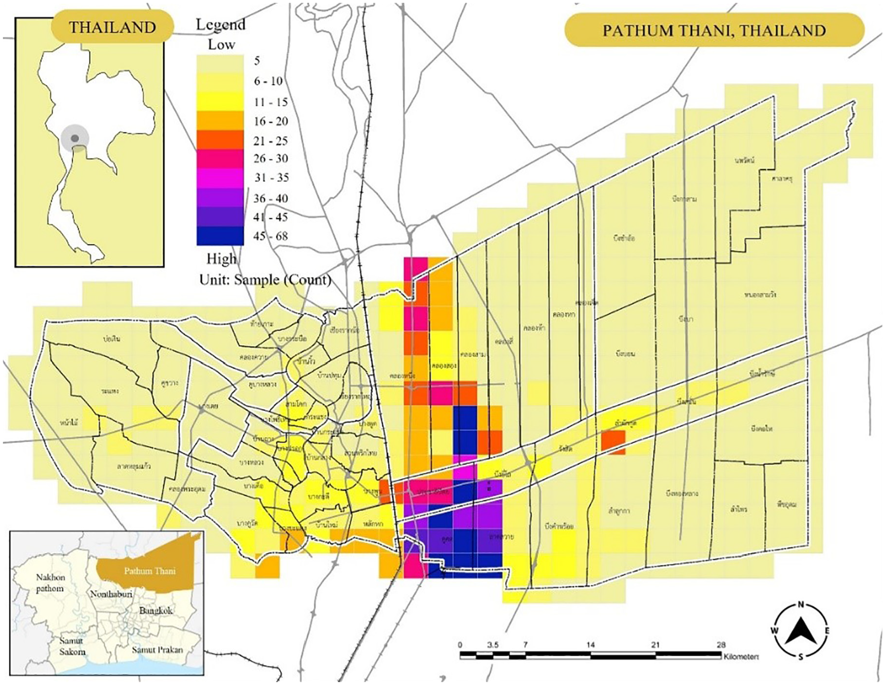
Study area and questionnaire distribution by grid of building density.
Data Analysis
To explore the trip behavior of the respondents’, structured data were collected for subsequent analysis. This study utilized a combination of spatial considerations in the sampling method, incorporating statistical sampling methods for the analysis. Specifically, a grid-based spatial sampling method was employed to ensure systematic and consistent distribution in alignment with the study area’s characteristics. This approach was chosen based on the understanding that the distribution of people is closely linked to urban density data. Furthermore, data collection, guided by spatial considerations, was executed, and the analytical process centered around research questions related to trips made by respondents within short distances (within sub-district areas), primarily using non-motorized vehicles, as illustrated in Figure 2. Additionally, the study investigated the relationship between internal trips made by the respondents and the spatial characteristics of land use patterns.
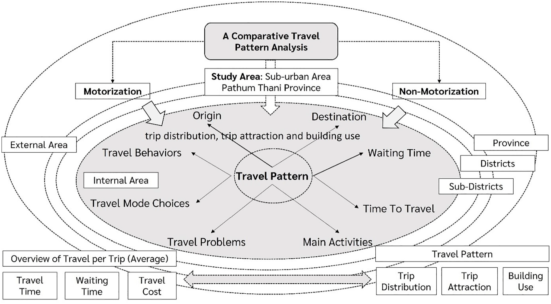
The concept of analysis.
The questionnaires incorporated data on travel behaviors, current residence, travel duration, waiting times, primary activities, typical travel mode choices from origin to destination, and challenges encountered during different travel patterns. Initially, we conducted an overview of travel patterns across the entire suburban area to discern the nature of these journeys and the time required to complete them.
Results
Based on the analytical concept illustrated in Figure 2, when examining all three modes of travel, it was observed that the majority of respondents utilized only one mode of transportation. Specifically, 95.80% of the respondents selected their private vehicles. Further details are outlined in Table 1 and Figure 3.
(1) Average waiting time: for buses, it was observed that the primary users typically experienced waiting times of 11 to 20 min. This prolonged wait may be attributed to the persistent traffic issues that continue to be a chronic concern in Pathum Thani province.
(2) Average travel time: it was observed that traveling in the city center typically required an average travel time of 21 to 40 min, while in the outskirts of the province, it took more than 50 min for a journey. When comparing the waiting time for the bus to the travel time within Pathum Thani province, it was evident that the duration of travel and waiting time were nearly equivalent within the study area. Consequently, a significant number of respondents choose personal vehicle travel.
(3) Average commuting expenditures: the study revealed that, due to a substantial daily traffic volume, the estimation of commuting costs exhibited a higher rate compared to other areas. It was observed that when traveling within the Pathum Thani area, travel costs exceeded 60 baht, whereas in other areas, the average cost was around 20 baht.
Transportation Characteristic of Respondents.

Significance (p-value) < .05

Characteristics of trip chain in Pathum Thani province by spatial visualization.
Table 2 provides a comprehensive analysis, revealing that the majority of the respondents were residents of Pathum Thani. When comparing the levels of trips (province, district, and sub-district) between internal and external journeys, it was evident that internal trips, particularly at the provincial level, were more predominant. Specifically, Table 2 illustrates the number of trips made by respondents within Pathum Thani Province. It is worth noting that out of 1,453 total trips, approximately 72.65% were journeys made within Pathum Thani province. Additionally, when we consider the number of trips at the district and sub-district levels based on respondents’ travel patterns, it becomes evident that the majority of these trips are intended for commuting outside their administrative boundaries.
Comparison Between Motorized and Non-Motorized Trips in Study Area.

Note. *Focusing the trips that pattern within the study area.
To provide further clarity, most of the trip patterns align with the decision by respondents to travel within the provincial area. These findings also suggest that, despite trips extending beyond the sub-district level, the respondents’ travel patterns predominantly center around the provincial area. Furthermore, when considering the types of motorized vehicles, it was evident that auto-dependency remained notably high, consistently across various trip patterns within the sub-district level. This study points out the presence of automobile dependency in the study area.
Considering the study area’s characterization as an urban-peripheral region, a comprehensive investigation into trip behavior quality is essential. Preliminary analysis revealed that approximately 87% of trips at the provincial level in Pathum Thani were made using motorized vehicles. However, the findings also indicated that a majority of the respondents had journeyed beyond the sub-district level, indicating the presence of urban land use patterns with significant destination nodes, such as universities, commercial, or residential areas. Data on trip distribution derived from the questionnaire survey showed that respondents’ trips were primarily within the district level, which could be considered as their internal trip characteristics. Nevertheless, the practical scenario exhibited several trip distributions based on urban fabric, as depicted in Figure 4.

Pattern of trip distribution both district level and sub district level.
In classifying trip patterns for this analysis, two primary types of mobility were considered: motorized vehicles (including private cars and motorcycles) and non-motorized vehicles (such as bicycling and walking), which represented the daily commuting patterns of respondent groups. A 60 × 60 trip distribution matrix was established to visualize the patterns based on the respondents’ Origin-Destination (O-D) data. The results of the analysis are illustrated in Figure 5, highlighting that, at the mesoscopic level, motorized trips and urban agglomeration were prominent, indicating that the majority of respondents predominantly rely on motorized vehicles for their daily trips.
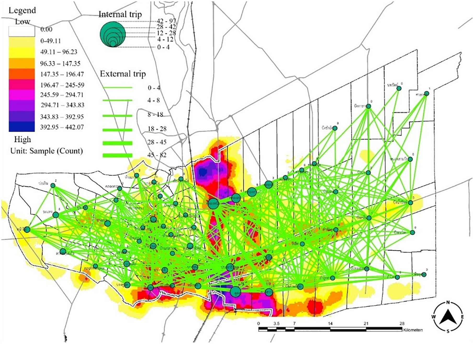
Motorized trip distribution and urban function distribution.
The analysis reveals that the most frequently traveled route among respondents was from Khlong Luang subdistrict to the Khu-khot subdistricts, accounting for 82 trips (5.91% of the total motorized trips in this study). The second most common route was from Khlong Luang subdistrict, comprising 78 trips (5.62% of total motorized trips). The third most traveled route was to Lat Sawai subdistricts, amounting to 45 trips (3.24% of total motorized trips). It is noteworthy that these top routes with the highest trip distribution can be categorized as intrazonal trips. However, the links with the highest trip distribution occurred from Prachatiphat subdistrict to the Khlong Nueng subdistrict, totaling 28 trips (2.02% of the total motorized trips in this study). The second most prominent link was between Khlong Si and Khlong Nueng subdistricts, with 1.73% of total motorized trips. Additionally, the third-highest link was from Khlong Song to Khlong Nueng, comprising 1.65% of total motorized trips. These high distribution zones align with the major road known as Chiang Rak Road, which serves as a crucial east-west corridor in Pathum Thani province.
From the analysis of non-motorized trips and urban function at the microscopic level, as depicted in Figure 6, the results revealed that several trips were conducted as intrazonal trips, specifically within the sub-district level, using non-motorized means of transportation. Some respondents also selected non-motorized vehicles for travel in key links within the study area, such as the Khu-Khot subdistrict. The total number of non-motorized trips amounted to 6.63% of non-motorized trips. The second-highest number of non-motorized trips, chosen by respondents, was to the Khlong Nueng subdistrict, with a total of 4.86% of non-motorized trips. Additionally, the third-most selected non-motorized trips were directed towards the Lad Sawai subdistrict, with a total of 4.42% of non-motorized trips.

Non-motorized trip distribution and urban function distribution.
In terms of the problems or constraints faced by respondents in this study area regarding trip-making, two analytical models were considered: private vehicle and public transit. Respondents had the option to make multiple selections (refer to Table 3). The results indicate that for motorized trips, the foremost challenge encountered by private vehicle users is traffic congestion. The second most predominant challenge pertains to transportation costs and expenditures, followed by concerns related to the availability of parking spaces. In the case of respondents utilizing public transit, similar issues were shared with those using private vehicles, with traffic congestion being a significant challenge (127 cases, 16.28%). A relatively smaller number of respondents highlighted travel costs as a challenge in choosing public transit (10 cases, 1.28%). However, when it comes to the use of public transportation in Pathum Thani province, most respondents identified their commuting challenges as related to the unknown schedule (105 cases, 13.46%), waiting time (97 cases, 12.44%), and the absence of transit stations near their residences (80 cases, 10.26%). These factors emerged as the top three key challenges in Pathum Thani province, reflecting citizens’ concerns about their future mobility.
Comparison Between Mobility Challenge Issue in Pathum Thani Province.

Note. Remarks: the respondents can select multiple choice as mobility challenges in study area.
Discussion
While trip distribution patterns in various cities are often influenced by their unique urban characteristics, the findings of this study, based on commuters’ opinions, reveal that a significant majority of respondents prefer to use private vehicles. This preference is primarily because the origins and destinations of the respondents are predominantly within the provincial area. Notably, a high level of auto-dependency is evident across various trip patterns, indicating a significant automobile dependency in the study area, which can be categorized as a peri-urban context. This observation aligns with the findings of Burchell et al. (1997), which emphasize that automobile dependency tends to be more pronounced in lower-density areas, particularly in urban peripheries. Similarly, Piorr et al. (2011) note that peri-urban areas around most cities are often characterized by a high dependence on private cars.
The absence of adequate public transportation services is a significant challenge contributing to daily commuting constraints. Numerous studies have highlighted the prevalence of car dependency in peri-urban areas, which are characterized by a combination of urban and rural settings, resulting in lower-density development. The lower passenger numbers in these areas render many public transportation services financially unsustainable. Several studies have addressed the issue of developing public transportation systems and their relation to car dependency. For instance, Holmgren (2020) investigated the impact of public transport service quality on car ownership, concluding that car ownership is influenced by the quality of service in the public transport system. Despite relatively short travel distances, the respondents’ preference for using motorized vehicles can be attributed to several factors, including the lack of public transportation services, inadequate coverage, accessibility, and service quality. Additionally, imbalances between trip production and trip attraction within the urban context may contribute to this trend.
In summary, it can be concluded that the development of public transportation significantly influences car dependency. However, some studies suggest that even with excellent mass transit systems, individuals still rely on cars (Cullinane & Cullinane, 2003). Analysis of the data reveals that the primary mobility challenges in Pathum Thani, whether for motorized or non-motorized trips, are closely associated with issues of traffic congestion and travel costs. On the other hand, individuals using public transportation face additional challenges in Pathum Thani, including a lack of information, safety concerns, and inconveniences related to accessibility and connectivity. These issues pose significant obstacles for all users of public transportation. This study contributes to comprehensive understanding of commuters’ travel patterns in peri-urban contexts by comparing personal motorization and non-motorization choices, thereby highlighting the challenges in achieving sustainable transportation systems. It gives emphasis to the prevalent reliance on cars for travel within the area. These findings provide a valuable framework for the development of urban policies in Pathum Thani Province, as well as in other cities with suburban characteristics that still face various transportation issues. It emphasizes the importance of integrated urban planning and transportation systems, with a focus on not only physical development but also economic and social aspects, as well as the needs of the residents.
Conclusion
This study’s primary objective is to conduct an integrated analysis that encompasses trip distribution, trip attraction, and building characteristic data, with a specific focus on comparing travel pattern analysis between motorization and non-motorization choices. Spatial analysis is employed through a geographic information system to visualize the relationships among trip distribution, trip attraction, and building characteristics. Statistical analysis is utilized to gain a comprehensive understanding of the sampled travel patterns. The results of this study provide valuable recommendations for future mobility development. These recommendations emphasize the importance of improving the quality of public transport services to align with the demand for various trip patterns and distributions. Furthermore, there is a need to enhance the support system for non-motorized modes in intrazonal trips and encourage road users to opt for non-motorized transportation for short trips. These considerations are of utmost importance for all relevant transportation authorities, as they are integral to achieving sustainability in mobility within peripheral urban areas in Thailand.
However, the limitations of this study suggest the need for further investigation into service availability and quality, including a locational analysis which could reveal varying patterns and underlying factors that were not captured in the initial study. Although face-to-face questionnaire data collection could reflect the supply side, the association between transportation demand and supply can be more comprehensively understood through a holistic analysis of the supply side, particularly the physical settings among different modes. This approach allows for a deeper examination of how transport infrastructure, accessibility, and service quality impact users’ demand, leading to more informed and effective transportation planning and policy making. Furthermore, future research incorporating real-time data could reveal the variations among different contexts of trip generator zones, providing a clearer perspective for land use and transportation planning. This could also offer valuable insights into users’ choices and alternative services. Finally, this approach can enhance the accommodation of local commuting behaviors by effectively linking both short-haul and long-haul trips. This integration promotes seamless connectivity between non-motorized and transit services, thereby reducing car dependency. Such a strategy not only supports sustainable transportation but also encourages healthier lifestyle choices and mitigates urban congestion and environmental impacts.
Footnotes
Acknowledgements
The authors gratefully acknowledge the support provided by the Thailand Science Research and Innovation (TSRI) Fundamental Fund for the fiscal year 2023 for the project entitled “The Quality of Life in Sustainable Urban Mobility, Suburban Areas, Thailand” (Contract No. TUFF 05/2566). This research was also supported by the Office of the Permanent Secretary of the Ministry of Higher Education, Science, Research and Innovation. The study was conducted by the Center of Excellence in Urban Mobility Research and Innovation (UMRI) at Thammasat University, Pathum Thani, Thailand.
Declaration of Conflicting Interests
The author(s) declared no potential conflicts of interest with respect to the research, authorship, and/or publication of this article.
Funding
The author(s) disclosed receipt of the following financial support for the research, authorship, and/or publication of this article: This research received funding from the Thailand Science Research and Innovation (TSRI) Fundamental Fund and the Office of the Permanent Secretary of the Ministry of Higher Education, Science, Research and Innovation.
Data Availability Statement
Data sharing not applicable to this article as no datasets were generated or analyzed during the current study.
Supplemental Material
Supplemental material for this article is available online.
References
Supplementary Material
Please find the following supplemental material available below.
For Open Access articles published under a Creative Commons License, all supplemental material carries the same license as the article it is associated with.
For non-Open Access articles published, all supplemental material carries a non-exclusive license, and permission requests for re-use of supplemental material or any part of supplemental material shall be sent directly to the copyright owner as specified in the copyright notice associated with the article.