
Abstract
This article explores the reasons behind the continuation of contentious dam projects in Japanese river basins. Though the River Law of the country was reformed in 1997, and subsequent sociopolitical developments raised hopes that river governance would progress toward a more environment-oriented and bottom-up model, basin governance in Japan remains primarily based on a utilitarian vision that sees rivers as waterways. This article reviews the Achilles heel of the 1997 River Law by examining some most contentious river valley projects, and concludes that a myth of vulnerability to flooding, short-sightedness of river engineers, and bureaucratic inertia combine to place basin governance in a time warp: as projects planned during postwar reconstruction and economic growth continue to be top priorities in policymaking circles while concerns over environment remain largely unaddressed.
Keywords
Introduction
On October 20, 2010, the largest selling daily in Japan, the Yomiuri Shimbun, featured a special report on the outlook for completion of some of the most debated river valley development projects in the country. This news report, based on an extensive survey in 56 prefectures and metropolitan bodies by the Yomiuri, claimed that there was strong support for continuation of all ongoing major river valley projects, including the bitterly disputed Yamba Dam project on the Agatsuma River valley in the Gunma Prefecture (Yomiuri Shimbun, 2010). This news story was extraordinary then, because the claimed evidence ran counter to a promise given by the Democratic Party of Japan (DPJ) that Japan will move away from building dams in its river basins and focus on a water governance scheme without depending on dams. 1 Within days of this report, on November 7, 2010, the Yomiuri featured the then MLIT (Ministry of Land, Infrastructure, Transport and Tourism) 2 Minister Mabuchi Sumio’s declaration to revoke a total stoppage of the Yamba Dam.
Debates over dams and basin governance policies are nothing new to Japan. During the postwar economic reconstruction and growth, Japan assiduously pursued a policy for “developing rivers”: building large dams for flood control and water supply to urban and industrial hubs (McCormack, 1996, 2007; Waley, 2000). Structural intervention in river basins of the land led to many problems; rivers were transformed from natural streams to concretized waterways, natural environment in the basins was disturbed greatly, and numerous pollution incidents came to light (Kada, 2006; Waley, 2005). The state-led schemes of designing rivers began to attract sharp criticism as high-speed economic growth tailed off during late 1980s (Wood, 2005), and Japan witnessed the emergence of an environmentally conscious civil society (Avenell, 2010). As far as governing rivers were concerned, a major change was evidenced by a major amendment to the “River Law” in 1997 (Ashida, Egashira, & Nakagawa, 2008; Gippel & Fukutome, 2000). This amendment made environmental conservation a prime target for basin governance, along with flood control and water supply. This was followed by a law that paved the way for small civilian groups to become stakeholders in policymaking 3 (Pekkanen, 2004, 2006). These events promised increased civilian involvement in matters related to environmental policymaking and governance.
Yet, when it comes to the ground reality, authorities have been painfully slow in implementing new policy directions, and promise of environment-oriented river-basin governance is still far from being realized (Ito, Zaima, Togashi, & Miyano, 2003; McCormack, 2007).
“New-age” river designing, beginning from the late 1980s, 4 promised to revert rivers to “natural states” (Seki, 1994; Shimatani, 2000) but this itself remains a contentious claim, as this designing paradigm is seen as limited, and human-centric (Y. Ono, 1997; Takahashi, 1998). It is difficult to identify what is “natural” for rivers in generic terms, as the natural environment of river basins can vary widely, but in this article we would use this term to refer to river basins (including the main river in a watershed, tributaries, basin forests, and human settlements) without large dams or similar regulatory mechanisms. The river basin is seen as an integrated system involving a main river (and possibly one or more tributaries)—and its surrounding landscapes: forests, alluvial depositions, and human settlements (Haslam, 1997; Newson, 1992). Haslam (1998) has used the term riverscape to describe basin landscapes that are connected by flowing rivers, but in this article, the term “landscape” will be used to denote the same.
While some scholars associated with river planning argue that post-1990s, basin governance schemes in Japan paid adequate attention to environmental conservation (Nakamura, Tockner, & Amano, 2006; Yoshikawa, Seo, & Yoshimura, 2007), others take a distinctly different view, noting that entrenched interests of politicians and construction lobbyists remain strong (McCormack, 2007). McCormack argues that the “Construction state” mechanism is still alive in the form of ongoing large valley projects in some of the most environmentally sensitive basin areas, and the state vision of river governance stems primarily out of the constructionist agenda.
This article centers on four brief case studies, and aims to give a critical analysis of how rivers in a supposedly “post-growth” Japan continue to remain in a state of perpetual shock, due to anthropogenic impacts on basin ecosystems. The article takes an environmental sociological view of this condition, and the reasons behind it: Therefore, it does not provide numerical or “scientific” analysis. This kind of approach is considered to be complementary to existing scientific studies measuring the amount of change in environments (Bates & Tucker, 2010; Berkes & Colding, 2000; Vaccaro, Smith, & Aswani, 2010). The case studies are based on review of available literature—including Japanese publications—and on the extensive field research carried out by the author in 14 river basins in Japan over a period of nearly 5 years.
The Nagara River Estuary Barrage and the New River Law
The Estuary Barrage over Nagara River near Nagashima in Mie Prefecture (map in Figure 1, photo in Figure 2), just before the river empties into the Ise Bay, 5 is one of the most disputed dam projects in the country’s history, The barrage was completed in 1995 but initial plans go as far back as 1959: when an Asahi Shimbun news feature broke the story (Ito et al., 2003, p. 2). The plan was eventually integrated as a part of the “Fundamental Plan for Developing the Kiso Watershed,” 6 adopted in 1968. Local fishermen’s unions became staunch opponents of the plan soon after it came to light, fearing extensive losses in the fish catch, due to the projected impact on the flow dynamics upstream. The barrage plan was finalized on July 31, 1973, seemingly ignoring strong local protests, as a petition with 26,650 signatories had been submitted to concerned authorities (Ito et al., 2003, p. 3). The reasons for the barrage were twofold. The first aim was protecting the low-lying urban areas from repeated floods of the Kiso River System. The three large rivers of the Kiso system, Kiso, Nagara and Ibi, historically flowed in alternating channels, resulting in frequent inundation of areas lying in between (Seki, 1994). The second aim was to provide water for a large industrial complex at the rivermouth. Another major feature of the barrage plan was to dredge the river upstream and prevent saltwater intrusion from the Ise Bay (McCormack, 1996).

Location of the Nagara River Barrage.

The Nagara river estuary barrage (photo by the author).
The flood proofing agenda gained strength in the aftermath of a massive typhoon that swept Mie Prefecture on September 12, 1976, triggering levee collapse in a section of the Nagara River. Activist writers like Amano Reiko have suggested that the opposition movements were either co-opted or subjected to various pressure tactics by local administrative and ministerial authorities (Amano, 2001). A final obstacle was removed when the Akasuga Fishermen’s Union, a prominent opponent, withdrew its objection on July 27, 1988 (Ito et al., 2003).
The barrage plan went ahead, but protests did not die out completely, either. Ito et al. observe that a new type of movement against the barrage emerged from 1982, calling for protection of citizens’ rights of enjoying unpolluted river basin environment, and especially, in the case of Nagara, protection of the bounties of the river (Ito et al., 2003). This movement took the form of monitoring the river environment after the barrage was erected, and occasionally, results of such monitoring were featured in local and national dailies. Independent observers pointed out that despite the arguments to the contrary put forth by hydrologists, the barrage had a drastic effect on some species of fish journeying upstream (Murakami, 1996).
In addition, the opposition movement against the Nagara Rivermouth barrage became a symbol of opposition to large river valley projects: All over the country, independent voices grew increasingly critical, and demands to appreciate and conserve basin environments grew stronger (Ito et al., 2003; Okada, Tatano, & Takagi, 2008; Waley, 2005). This momentum led to a fundamental change in the laws that governed rivers in Japan, and in 1997, the “New” River Law 7 was passed (Wada, 2009).
The “New” River law is substantially different from its predecessor because it adopts two important clauses. The first clause stipulates “maintenance and preservation of river environments” as a fundamental goal of river basin governance, 8 while the second important clause recognizes civilian participation in decision making on river governance defined as “stakeholder participation in matters of benefit or harm regarding basin management policies” (Wada, 2009, p. 40). The first clause sought to address concerns that emphasis on flood control and water supply up to that time had harmed basin ecosystems to a large extent, and had had detrimental effect on the basin landscape. The second important clause was effected by rising civilian discontent and activism over large river valley projects, notably the Nagara River Estuary Barrage case (Wada, 2009). In addition, for the first purpose, the “Basic Plan for River Maintenance” was supposed to monitor river basin ecosystems and human impacts over a 20- to 30-year scale and come up with alleviation measures to reduce the stress on riverine ecosystems (Wada, 2009). This should be done following a “basin-oriented approach,” one that takes a holistic account of the whole basin environment, rather than merely measuring the water quality of a river (Yoshikawa et al., 2007). Construction of dams and barrages was to be avoided as much as possible for their detrimental effects on the riverine ecosystems (Ashida et al., 2008). Maintaining naturally diverse basin landscapes would require long-term monitoring of the basin ecosystems, their responses to existing flow control structures, or fresh interference on the system (Ashida et al., 2008). A longitudinal appraisal of the basin ecosystems was to be attempted for preserving the natural environment. This emphasis on nature was also reflected in the term ‘Tashizengata Kawazukuri’ (Designing or constructing naturally diverse rivers).
However, nearly two decades from the inception of the Tashizengata Kawazukuri and more than a decade after the New River Law, the picture is not comprehensive when it comes to successful implementation of these policies. It is true that Japanese rivers have recovered in most cases from the horrible industrial pollution of the 1960s and 70s (Shimatani, 2000). But in most cases, it has been a tale of recovery from a bleak, horrible scenario to something that is better, but not substantially natural, by any means. Most Japanese rivers, and especially large river systems, are tightly controlled by human hands, and structural measures like dams, weirs, barrages and concrete embankments and fortified or artificially straightened channels have forced rivers to follow paths chosen by river engineers. In some high profile cases, conditions of streams that were known for their purity even a decade back have even actually become worse. A prominent example of this is the Shimanto River in Shikoku.
A Small Dam on the So-Called “Last Pure River”
The 196-km-long Shimanto River (Figure 4) flows through the Kochi Prefecture in Shikoku; it has a total basin area of 2,200 km2. It is one of the very few large rivers without a large dam. A map of the basin is given in Figure 3 below. It is popularly known as the “last pure river” of Japan, 9 although its water quality is not at the top of the national water quality list. 10

Map of the Shimanto River Basin area.
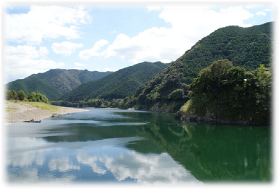
Shimanto River in Shikoku. The photograph shows the lower reach of the river, where it flows through the Shimanto City (photo by the author).
In recent years, this river has shown a number of alarming tends, as far as the basin ecosystems are concerned. The numbers of ayu (sweetfish)—which is a famous delicacy—have dwindled to such an extent that now only a few are caught at downstream reaches in autumn where a decade back boats would fill up with catch (Nippon Hôsô Kyôkai [NHK], 2006). A small hydropower dam at the upstream at Ieji River, a tributary stream to Shimanto, has starved the Shimanto of a large part of its water supply, which is implicated by local residents for the decline in ayu numbers (A. Ono, 2010). The Ieji River Dam, officially known as the Saga Diversion Weir, is located at about 86 km downstream of Shimanto’s origin on the Ieji River. It was built in 1937 and is operated by the Shikoku Electric Company (A. Ono, 2010). It is a small dam compared with the huge rivermouth barrage in the Nagara, and has a height of only 8 m. 11 In a local-level survey implemented by Ono at Towason area (now amalgamated into the Shimanto Town) in 1999, a large portion of respondents had the opinion that the natural environment had become worse in the area compared with 10 years before, and cited loss of fish variety, reduction in water level, and reduction in water clarity as indicators (Ono, 2010). About half (50%) of all respondents saw the Ieji River dam as an “unnecessary” structure (Ono, 2010, p. 180).
Yet, when it came to deciding whether to revoke or renew Shikoku Electric’s right to run the dam in 2001, the governor of the Kochi Prefecture chose to extend its operation (Ono, 2010). What was the reason behind this decision that overrode strong local sentiment? Ono (2010) argues that the governor’s office could not override the strong nexus between the Shikoku Electric, The Nakamura Regional Construction Bureau, 12 Shikoku Regional Construction Unit of the MLIT and the economic interests of Ministry of Economy, Trade and Industry (METI). 13
Ironically, in cases when a proposed dam or river valley project has been halted, or scrapped, and such instances are rare indeed, governors have played a key role by exercising their authority to judge whether the project is in line with the benefit of the prefecture and its residents. Such a judgment was recently passed by Kumamoto
Prefectural Governor Kabashima Ikuo, when he decided to freeze the Kawabegawa Dam after half a decade of controversy (Takahashi, 2009) and then in February 2010 decided to revoke the operation continuation decision of the Arase Dam on Chikuma River (Kumamoto: Arase Damu wo Tekkyo e, 2010). The former governor of Nagano, Tanaka Yasuo (governor between the years 2000 and 2006) is also widely credited for officially establishing the Datsu Damu Undô (Dam Removal Movement), which has steadily gained voice all over Japan. Unfortunately, to this date, such efforts shine like rare beacons in darkness, and have only come from extraordinary individuals with strong independent vision, or in cases where local opposition was so strong that it could not be overridden. In general, governors are not key actors in basin governance policymaking, and they often find it extremely hard to override the combined interests of state level policymaking bodies such as the MLIT and regional level construction lobbyists, who share a close relationship based on mutual benefit.
Yamba and Tokuyama: Instructive Examples
Barring few extraordinary instances, dams dominated state policies of river basin management in postwar Japan. To this date, state-level planning bodies enjoy a position of unparalleled authority while framing schemes for river basin “development.” This is evidenced in the continuation of large river-valley projects for decades, even in the face of widespread condemnation by scientific evidences and public anger. A case in point is the Yamba Dam in Gunma Prefecture (Location map in Figure 5). This multipurpose river valley project in Naganohara Machi is the most expensive dam in the country’s history. The project has remained unfinished for over half a century, and building of the dam itself is yet to start, although roadways and tunnels associated with the dam have been nearly completed. The Yamba Dam was planned in 1952, on the Agatsuma River, a tributary of the Tone River, the largest river system in Japan in terms of basin area. The main reason behind the planned dam was preventing a flood like the one caused by Typhoon Kathleen in 1947, which tore down embankments in Tone River Basin in several places (Miyaharada, 2010, p. 46). Similar to the Nagara Rivermouth Barrage controversy, the dam ran into trouble as soon as plans were drawn. The reservoir was set to inundate the historically famous Kawahara Yu Onsen in Naganohara, and many residents raised the point that a large reservoir would not be practical as the Agatsuma River is extremely acidic. Miyaharada puts the total cost of the project at 880 Billion Yen at 2004 (Miyaharada, 2010). Intriguingly, the dam itself, if completed, would cost only 9% of this enormous figure; the rest is accumulated through the network of roads and tunnels, various taxes and compensations. The central government bears more than half of all the cost and the remainder is shared by Saitama, Chiba, Gunma, Tochigi, and Ibaraki Prefectures. In 2008, the then Liberal Democratic Party (LDP) Minister of Land Infrastructure and Transport quoted figures in parliament that showed Yamba dam would have only a negligible effect if completed, in cutting out the flood peak in the lower Tone Basin if another typhoon in the scale of Kathleen were to hit the area (Miyaharada, 2010). Even without simulated figures, it is easy to understand the redundancy of the dam as water control project; in 58 years since the plan of the dam was made, there has been no instance of another flood of the 1947 magnitude. Various river valley projects in the Tone River Basin have substantially altered the nature of the river system, effectively limiting any chance of a catastrophic flood like the one in 1947.

Location of the proposed Yamba dam.
The DPJ, which ruled the country from 2009 to 2012, asserted in its election manifesto that it would seek the stoppage of the project if it came to power (Fackler, 2009; Okada, 2010). After it came to power, the party chose not to deliver on this promise. In his visit to the dam site in 2009, the then MLIT Minister Maehara Seiji proclaimed that the dam itself would remain frozen, while associated construction would go ahead. In 2010, his successor Mabuchi Sumio even withdrew this statement. Since the 2012 election, the LDP, which is seen as sympathetic to the dam, is in power. The proposed dam will not only destroy beautiful towns and inflate the total cost of the project, but projected impact on a number of rare flora and fauna is also devastating (Association for Concerned Citizens for Yamba Dam Project. n.d.). Imamoto Hirotake, the ex-chairman of the Yodo River Watershed Committee (Imamoto & Shukan SPA Damu Shuzai Han, 2010), observes that Maehara changed his opinion about the dam after he was made to tour through the vast network of tunnels and newly constructed roads by the River Bureau and regional officials—suggesting that even top level ministers are subjected to overwhelming indirect pressure by bureaucrats in the River Bureau and prefecture level officials to keep construction works alive. In most cases, prefectural level construction units are headed by officials linked to the MLIT River Bureau or Roadways Unit, and this mechanism gives the MLIT a tight control over budgets of prefecture-level projects. This system sustains the “iron triangle” between the MLIT River Bureau, Regional Autonomous Bodies, and the Dam proponents (Imamoto & Shukan SPA Damu Shuzai Han, 2010, p. 189; McCormack, 2002).
The Tokuyama Dam (map in Figure 6, photo Figure 7), completed in 2008, is the largest dam in Japan in terms of reservoir capacity. Standing 161 m tall, with rock-filled walls extending 427.1 m (Tokuyama Dam Control HP, n.d.), this dam has created a massive reservoir in the upper Ibi River Basin in Gifu Prefecture—and inundated a whole village during construction. This village, as captured in an ethnographic study by Onishi (2007), managed to live in a “different world,” villagers relying on subsistence farming, bounties from the rich primary forest in area, and the river for livelihood. When the dam reservoir forced the villagers to relocate, a whole body of indigenous knowledge and culture became the collateral damage of this ambitious project (Y. Kondo, personal interview, January 9, 2011). One of the main candidates for the water supply, Nagoya city, subsequently decided to withdraw its stake of receiving water from the Tokuyama Dam, due to surplus water in the metropolitan area (Kondo, 2009)—raising further questions on the dam’s need and utility. A major ongoing scheme of the MLIT is a 44-km-long tunnel to carry water from this dam 14 to Nagara and Kiso rivers, the so-called Tokuyama Damu Dôsuiro Project, with the argument that these rivers are short of water in drought years.

Location of the Tokuyama Dam on the Ibigawa River, in Ibigawa Town, Gifu.
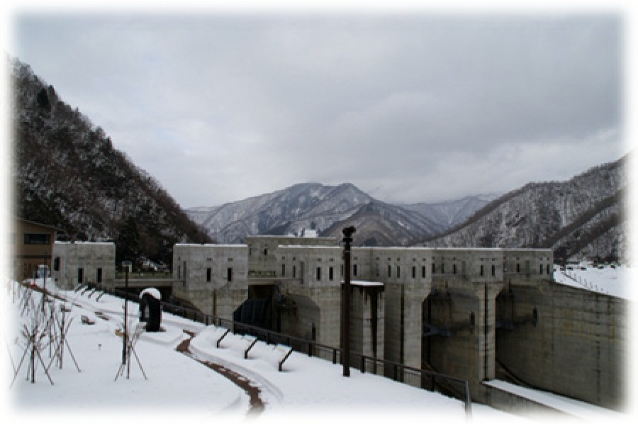
Tokuyama dam (photo by the author).
However, as Kondo (2009) claims, there has been just one instance where Nagara and Kiso were affected by a serious drought in recent past, and that too did not cause an absence of water in these rivers, and the Dôsuiro project is planned without a proper Environmental Impact Assessment (EIA) looking at the possible impact of imported water to Nagara and Kiso basin ecosystems (Kondo, 2009). She also claims that water that channeled into Nagara and Kiso will come from the middle layer of water in Tokuyama Dam, which is colder, has very different physical properties, and when channeled through the artificial tunnel at high speed will have detrimental effects on the Nagara and Kiso environments (Y. Kondo, personal interview, January 9, 2011).
The Debate Over the Kawakami Dam and the Plight of Giant Salamanders
As the cases involving ambitious basin development schemes show, Japan has fared poorly in stopping high profile construction projects, even at the face of public outcry, or research evidence indicating negative repercussions on the natural environment of river basins. There are even examples where state-level policymaking organs chose to override policy recommendations given by expert committees specifically appointed to resolve contentious issues.
The Yodo River Committee is one prime example. This committee was set up under the Regional Office of the MLIT in 2001, and comprised of several renowned experts of rivers. The creation of this committee was considered a groundbreaking approach, as the committee was supposed to provide policy guidelines in consistency with real needs of the citizens (Ashida et al., 2008). During its tenure, the committee suggested scrapping of several dam projects in the heavily urbanized Yodo River basin (map in Figure 8).

The Location of the Kawakami Dam. The dam is set to be built near the confluence of the two small rivers located at the center of the image, below the landmark, Aoyama JHS.
One of the disputed projects is the Kawakami Dam on the Maefukase River, which is projected to endanger the habitat of giant salamanders found in the area (Yodogawa Suikei Ryûiki Iinkai, 2005, 2009).The MLIT chose to override the committee’s recommendations and is persisting with the project at today’s date (Imamoto & Shukan SPA Damu Shuzai Han, 2010; Miyamoto, 2010).
The Kawakami Dam has grabbed headlines due to the enormous environmental destruction it would cause, as noted above, to the habitat of the Giant Salamander, a prehistoric creature that once thrived in many parts of the upper Kizu River Basin, but has now been reduced to only a handful of locations due to habitat destruction and the fact that it can live in only very clean water (one of the last remaining habitats is the Taki River, photographed in Figure 9). The Kawakami Dam Construction Authority claims that they are making artificial habitats of the Giant Salamander, and preserving the creatures for later release in upstream reaches (Kawakami Dam Construction HP, n.d.) but they remain silent on the impact of changes in the physical environment on this species. The Giant Salamander is the apex predator in its food chain, and damming the Maefukase River will substantially alter the basin landscape. Though there is no scientific study monitoring the effect of dams on salamander habitats, a historical geographical view suggests important leads. While the giant salamander is rare in the Kizu River watershed today, the creature was abundant till the 1980s in the area (K. Fujita, personal communication, July 12, 2010). Local residents point out increased turbidity, decline in flow volume, and reduction in the fish stock as major changes in the watershed after several multipurpose dams were built from 1960s to the late 1990s. This overall change hints that these indicators are strongly correlated with the decline in the salamander numbers, as the species is known to do poorly in polluted waters and survives almost exclusively on fish. With the dam in all likelihood changing the whole basin drastically, causing turbidity and eutrophication upstream, and a reduction of flow downstream, would the salamander be able to find the crystal clear waters it needs to live, and would there be enough fish for it to survive on? Independent observers and civilian activists replied with an emphatic no, adding that releasing captive salamanders would create a scenario where there would be high intraspecies competition for food and breeding grounds, and smaller members of the species would likely end up being eaten by their larger brethren (Y. Kondo, personal communication, January 9, 2011; E. Takeda, personal communication, July 10, 2010). Even now, and seemingly contrary to the ethics of preservation that demand conservation of the species habitat along with preservation of its individual members, the salamanders are being kept in “salamander pits” (Figure 10), water tanks made of concrete or plastic, inside a shoddily maintained cage near the dam site, with very little space for an individual to move. The piecemeal approach taken by the state-affiliated organs to preserve this apex predator in captivity, while destroying most of its food chain and habitat, shows the hollowness of conservation logic that state-level planning bodies such as the MLIT uses.

Taki river, a tributary in the Kizu river system and one of the remaining habitats of the giant salamander (photo by the author).

Salamander pits at the Kawakami dam site. The giant salamanders are kept in captivity here, and the environment is in stark contrast to that of the Taki river, photographed above (photo by the author).
Like the Yamba, the Kawakami also fares poorly as a planned flood control mechanism. The Yodo River Committee specifically pointed out that the two main aims for the project, flood control and water supply, are redundant. The Kawakami Dam can only cut off 11% of the total inflow in the Kizu River at Iwakura Point, before it reaches downstream urban areas, and consequently would only be able to cut off a few centimeters from the flood peak (Yodo River Committee, 2005). Besides, due to rural depopulation, many regions have surplus water, and after Nara Prefecture and Nishinomiya City withdrew from the water supply scheme, the dam project is left with the role of supplying only 0.3 cumec of water to its potential customers. The committee observed that this small amount of water could easily be secured from the other dams in the watershed (Yodo River Committee, 2005).
Discussion: What Makes Age-Old Dam Schemes Persist
The Myth of Vulnerability
A seemingly baffling question is: why, in spite of citizen protests and evidences of negative environmental impact, dam projects live on for decades in Japan? A major reason is the lingering fear of flood damages, similar to those in the immediate postwar period. Floods, especially typhoon-induced flash floods, proved to be highly damaging during that stage of Japan’s history, for the country was rebuilding after the devastation caused by the Pacific War, and newly created urban infrastructure as well as rural communities were extremely vulnerable to natural hazards. This need was subsequently augmented by the need of water supply in newly developed urban areas and industrial complexes. This socioeconomic phase came to an end in the 1980s, when Japan started to move into a post growth direction. Today, cities are well protected from natural hazards such as floods, advanced warning systems are in place, and rivers are diked or dammed in countless places to prevent anything remotely as dangerous as floods caused by Typhoon Kathleen of 1947 or the Ise Wan Typhoon of 1959. As the case of the Yamba Dam testifies, in more than half a century’s time, the Tone River Basin has not witnessed flooding on a similar scale. On the contrary, in the case of Kuma River basin in Kyushu, a damaging flood was caused by water release from the Ichifusa dam (Takahashi, 2009). Nevertheless, the MLIT and its coordinating organs emphasize on the merit of dams as protection mechanisms against floods, and Japan is repeatedly portrayed as a country perpetually threatened by flood hazard (Japan Commission on Large Dams, 2009; Seki, 1994). A major postwar flood event that seems to have permanently scarred public memory is the infamous Ise Wan Typhoon, which killed thousands across a large area (Oka, 2009). Interestingly, the Ise Wan typhoon continues to be referred to justify the ongoing Kawakami dam, even after five dams have been built to combat floods in the Kizu River watershed.
Like the Kawakami, most dam projects in the planning phase today are relics from the past. One major argument is that they are continually supported by the state organs as they benefit construction lobbies (McCormack, 1996, 2007; Uzawa & Okuma, 2010; Yamamoto, 2009). These projects are increasingly out of date in terms of water supply as well. Japan has entered a phase of depopulation, and freshwater demand has dropped consistently. This was evidenced by Nagoya and Nishinomiya’s withdrawal from Tokuyama and Kawakami projects, respectively. It is argued that rivers in Japan are already overladen with dams and other regulatory structures, and it is imperative to allow them flow more freely (Takahashi, 1998; Yamamoto, 2009). It has also been noted that some degree of inundation and flooding must be allowed to protect the basin environments and replenish low-lying areas with alluvium, which is trapped as silt behind the concrete walls of large dams (Okuma, 2007).
The Achilles Heel of the Law
How then has the state been so successful in keeping these mega river valley projects alive, even when they are out of tune with the demands of the society today? The Achilles Heel of the 1997 River Law is that it is only effective for projects that have begun or were planned after its passage. As discussed earlier, most dam projects in Japan were planned during the economic boom years, and thus are not subject to scrutiny under the 1997 standard. Dam-building authorities claim that they are trying to implement stringent measures to safeguard the environment, but such claims are hollow, and as in the case of the Kawakami Dam, no proper EIA has taken place (E. Takeda, personal communication, July 10, 2010). In the absence of a stringent scrutiny based on the most recent standards, dam projects continue to harm basin environments, as ongoing construction keeps the river system under a state of perpetual shock. In addition, river designers continue to argue that environmental conservation must be coordinated with the two other goals: “Flood Control” (Chisui) and “Water Supply” (Risui) (Ashida et al., 2008, p. 5). This approach suggests that a utilitarian policy ethic, rather than a conservation oriented paradigm, still dominates river basin governance in Japan today. Environmental concerns are only incorporated to the extent that they do not cause substantial discomfort to pursuers of the old line.
The Short-Sightedness of River Engineering
The case studies described above indicate that river designing in today’s Japan is still based on a utilitarian ethic that sees rivers primarily as waterways. Even experts who are associated with river planning, and have written extensively on “Natural River Construction” efforts, have scarcely mentioned ways to preserve old growth forests in the remaining areas of the basin. Old growth forests in Japan have been systematically replaced by plantation forests, and these plantation forests almost exclusively comprise of only two species, Cryptomeria japonica (Sugi or Japanese cedar) and Chamaecyparis obtusa (Hinoki or Japanese cypress). These plantations have poor water retention capacity compared with more species diverse old growth forests or secondary broadleaf forests. This has resulted in drying up of numerous small streams in Kumamoto Prefecture (Hirano, 2009; T. Hirano, personal communication, December 2, 2010; Shidei, 2006). Plantation forests are also poor in biodiversity; thus, once an old growth forest in a basin is cleared or even partially felled, the ecosystem balance of the whole basin receives a profound shock (Hirano, 2009; Ouchi, 2011), but this has been rarely appreciated in policymaking circles. Recently, there are proposals to replace concrete dams with “green dams,” implying preservation of basin forests that prevent swift runoff into the river channel and landslides (Fujihara, 2009; Takeshi, Tatematsu, Yamada, & Amano, 2008). In his seminal work on the role of forests in preventing floods and stabilizing river basins, Fujiwara (2009) has quoted figures from various sources to approximate the total economic worth of Japanese forests at a staggering nearly 75 trillion Yen in the year 2001 (Fujiwara, 2009). Such a precious resource is depleted by dams and associated roadways projects, selective logging and replacement of old growth forests with plantation forests. Fujiwara makes a compelling case for preservation of this asset, but to this date, there is little recognition at the official level that forests provide flood control, and the emphasis remains on artificial structural measures like dams. Another shortcoming of the “Natural River Construction” approach is that since the 1990s, the term “construction” has been prominently present in nearly all influential policy documents (Ashida et al., 2008; Seki, 1994; Shimatani, 2000; Yoshikawa et al., 2007). The main objective of restoration is creating pleasant landscapes for leisure activities. While this approach is commendable, it is not adequate as a paradigm for preserving the natural environment of river basins. The outcome of this approach is a human-controlled nature, and there is no scope for this nature to act in dynamic manner, that is, by causing floods or changing landscape features. Most rivers in Japan today are almost totally controlled by human hands; even the so-called natural rivers like the Shimanto are far from natural.
A major problem of large dams has been the breakdown of alluvium supply mechanisms in downstream areas and accumulation of silt in the dam reservoirs. Over the years, large amount of trapped silt chokes reservoirs, depriving them of their capacity to store clean water as well as reducing the efficacy of dams in cases of catastrophic floods. On the other hand, downstream reaches of river basins are deprived of silt supply, causing depletion of ecosystems and coastal erosion. This type of changes has been observed in the case of the Kizu River, a tributary of the Yodo River Basin. This river was once a main traffic route (Totman, 1998) and a typical feature in the downstream areas was the shiny sand that the river washed down from the upstream. But today dams in this watershed have severely reduced water supply, the river is barely a meter deep in the downstream and the famous shiny sand is now mostly trapped behind dam walls, while the river water has become distinctly muddier (K. Fujita, personal interview, September 14, 2009).
Fractured Top Brass and Powerful Bureaucracy of the Japanese State
Another important factor that keeps the status quo of tight bureaucratic control over river valley projects and the almost exclusive authority of the MLIT intact is the instability of the Japanese government itself. Before the DPJ came to power in 2009, its election manifesto called for stoppage of Yamba and Kawabegawa Dams. The main voice behind this was of the then Prime Ministerial candidate, Hatoyama Yukio. However, in consistency with the notoriously short-lived nature of the country’s Prime Ministerial position, Hatoyama did not even last a single year. Since then, the DPJ became embroiled in bitter power struggles between factions supported by Kan Naoto, 15 and Ozawa Ichiro. In 2012, the DPJ itself lost the mandate and was replaced by the LDP. In this scenario of rapid changes in the top political leadership, or the incumbent parties, the only continuity in the policy mechanism is the bureaucracy. This scenario has been complemented by the perception of Japan as a flood-prone country, perpetuated by river engineers with ties to the MLIT and the media—which has remained extremely sensitive over issues of life and property damage due to heavy rainfall and storm surges. This perception of impending disasters ignores the fact that many disasters today are outcomes of human designs; in the case of river flooding, there are even evidences that impervious concrete surfaces have contributed to swifter runoff leading to floods in several river basins (Stalenberg & Kikumori, 2008; Takahashi, 2009). As one civilian activist put it, building dams for flood prevention is similar shooting arrows in the dark: Dams are only effective if the rainfall is limited to the catchment area on which they are located, and this remains a completely arbitrary phenomenon (Y. Kondo, personal interview, January 9, 2011).
Conclusion
Caught in a Time Warp
Based on the foregoing discussion and the evidence generated by review of the relevant literature, and field research, this article comes to the conclusion that the Japanese river governance policy is caught in a time warp. Not only are age old dam plans kept alive at an enormous cost, citing less than convincing threat scenarios and often unreal demand scenarios, but the implementation of environment-oriented governance has also not been grounded in a consistent manner. The result is not only the destruction of the environment but also a waste of finance. In general, state-supported planners are sympathetic to dams, and when, in rare cases, state-appointed committees give opinions to the contrary, they risk being ignored completely. The sensitive topic of the Giant Salamander’s habitat destruction as a result of the Kawakami Dam has made dam construction authorities run their own surveys on the impact of the dam, and they claim that the impact will be minimal and can be ameliorated through artificial preservation schemes. But the salamander is only one inhabitant of the river basin; it shares its habitat with many other species, big and small. There are no efforts toward preserving these flora and fauna. Often, the biggest impact of a dam or barrage is seen among the fish stock of a river, which constitutes the salamander’s diet. Thus, despite efforts to preserve the salamander, questions remain on what state the river will be after the dam is built. Another major failure of policymaking has been the inability to decentralize river basin governance from a small coterie of bureaucrats. So far civilian bodies fighting against dams have remained as protagonists, and they are generally left out of formal policy decisions. It can be argued that this approach undervalues a major asset, which is the high level of expertise and environmental consciousness shown by citizens’ movements in postwar Japan. One of the first publicized case of state-local society conflict regarding dams was the movement against the Shimouke Dam in Japan (Commission on Large Dams, 2009) led by Murohara Tomoyuki, which is regarded as the starting point of anti-am civilian protest movements in Japan. A more recent example includes village chief Fujita Megumi’s successful struggle against the Hosokawa Dam in 2000 (Fujita, 2004), which became the first successful attempt to stop a large dam’s construction, the struggles against the completed Nagara River Estuary Barrage (Amano, 2001) and the Yoshino River Removable Barrage (Kubota et al. 2008). Even in case of the Yamba Dam, resistance by locals started from the stage of initial planning (Miyaharada, 2010).
Most civilian movements though fail to succeed as far as the main agenda is concerned, that is, halting dam projects. An additional challenge for the campaigners against dams has emerged in recent years: With the increase in the graying population, civilian movements are in danger of becoming unsustainable as leaders age rapidly and many movements have no successors to carry on (Y. Kondo, personal interview, January 9, 2011). The urbanized young generation of today’s Japan has little day to day contact with rivers, which raises the possibility that the tradition of protesting against human intervention on rivers may be replaced by a more detached and indirect approach (Hirata & Kada, 2006; Kada et al., 2006). There are some cases where dam authorities are promoting dam tourism, like in the case of the Tokuyama Dam, but tourists visiting these places are taught about the “utility” of the dams, while the enormous profligacy of expenditure and the negative effects on ecosystems are hardly mentioned. This scenario demands extensive documentation of the relationship between local societies and rivers, a longer temporal scale to understand changes in river systems, and the importance of the natural environment to sustain rich local cultures, failing which the worth of a natural river system risks being permanently overlooked or not understood at all.
Footnotes
Declaration of Conflicting Interests
The author(s) declared no potential conflicts of interest with respect to the research, authorship, and/or publication of this article.
Funding
The author(s) received no financial support for the research and/or authorship of this article.