
Abstract
This article presents a methodology that combines methods of architectural representation with qualitative social science research to study housing, particularly, home-based work. Studies of home-based work have specialised in discussing the complexities of sharing the domestic and productive spaces. However, the literature shows that there is a methodological gap in approaching these complexities. Specifically, both social science and architectural techniques separately fail to represent the relationships and conflicts between these two spheres. This article addresses the following question: how to achieve a representation that corresponds to the complexity of the relationship between domestic and productive space in dwellings? To answer this question, our methodology combines the techniques of architecture (sketches, plans, maquettes and axonometries) and social science (observation, interviews and focus groups) to capture the relationship between domestic (reproductive) and work (productive) spaces in households. The method presents three scales of analysis: the micro (household), the meso (part of the neighbourhood) and the macro (neighbourhood). These different scales of analysis were applied in two case studies to test the performance of the method. These are the transitional emergency neighbourhoods built after the 2015 floods in Atacama (Chile). These cases were selected because, for many families, housing is also a place of income generation, and often emergency housing is a place of work, contributing to the economic recovery process after a disaster.
Introduction
In recent decades, the concept of the home as a place where a family can live and reproduce has become increasingly contested. The distinction between the public and private spheres, once the defining boundary between two seemingly opposing spheres of society, has become blurred. This is due not only to the historic entry of women into the workforce in the 20th century, but also to the blurring of public and private spheres in everyday human interactions.
Feminist theory has been critical of this dichotomy. In the 1960s, Betty Friedan criticised the confinement of women to the domestic sphere, perpetuated by patriarchal ideas that focused attention on the home and women's roles (Friedan, 1963). In the 1980s, liberal feminism drew attention to women’s experiences of the home and gender relations. Carole Pateman points out that women have been confined to the domestic sphere (the ‘home’) because of a ‘sexual contract’: a hostile agreement between heterosexual men to share access to the productive female body (Pateman, 1988). The feminist slogan ‘the personal is political’ emerged as a means of asserting women’s liberation. Pateman points out that women have the capacity to move freely between the public and private spheres, allowing them to forge social connections both inside and outside the home. Postcolonial studies of the home by African American feminists in the 1980s challenged the dichotomy between public and private, fixed and fluid, and the home as a space of oppression or resistance (Longhurst, 2012). These ideas influenced the 1990s and 2020s queer and post-structuralist approaches that turned their attention to the relationships between home, identity and representation, deconstructing the binary public/private division (Longhurst, 2012). The current conceptualisation of domestic work aims at recognising domestic tasks as paid work (mostly performed by women), but this does not resolve the discussion about the home as a productive space. These approaches to the home have overlapped and informed each other over the past decades.
Just as these movements and conceptualisations have challenged the public/private dichotomy, so too have the crises of our time. One example is the crisis caused by COVID-19. The pandemic led to changes in all aspects of society, resulting in adults, children, the elderly and pets having to coexist in the same space: the home (Doling and Arundel, 2022). Similarly, the climate crisis and the occurrence of extreme hydrometeorological events pose a risk to the integrity of cities and societies. This risk is exacerbated in vulnerable and unequal areas, potentially leading to the displacement of affected communities. In such cases, housing plays a critical role in community recovery processes. Not only does it provide safety and security as a refuge for households, but it also acts as a productive economic space (Gough, 2012). While domestic work is a current conceptualisation aimed at recognising domestic tasks as paid work (mostly performed by women), it does not resolve the discussion about the home as a productive space.
The concept of home as a dual space, serving both domestic (home) and productive (work) activities, has been conceptualised in several ways. One approach has been through social reproduction theories, which demonstrate the integration of the production of goods, services and life. This process includes predominantly female household activities, referred to as ‘domestic work’. In this context, social reproduction theories argue that capitalism, as a cohesive system, effectively integrates the spheres of reproduction and production, albeit with inequalities (Federici, 2012). Notably, domestic work plays a crucial role in the growth of the GDP in most countries, thus highlighting this issue (Carr et al., 2000; Oelz and Rani, 2015). However, domestic work remains unacknowledged, resulting in notable disparities for women (Tomei, 2011).
Thus, in addition to its domestic role, the home is in many cases a place of income generation (Chen and Sinha, 2019; Gough, 2012; Gough and Kellett, 2001; Kellett and Tipple, 2000; Tipple, 1993, 2005; Tipple et al., 2001; WIEGO, 2020). Activities may include the sale of products, repairs, services and the production of clothing. Terms such as home-based work (HBW), home-based enterprise (HBE), home-based income generation (HIG) and home-based economic activities (HBEAs) have been used to refer these activities. These terms encompass the multiple uses of the home including economic activities, whether through self-employment or subcontracting, formal or informal. Although perceptions of the use of the home as a workplace are mixed, this duality has been shown to have beneficial effects on the local economy by providing jobs, goods and services to the neighbourhood (Wagemann et al., 2022). In addition, economic activity in the home is generally the main source of income for households in vulnerable contexts (Tipple et al., 2001). For example, in post-disaster contexts, the home can serve as both a productive space for economic recovery (Barakat, 2003; Kellett and Tipple, 2000; Setchell, 2001; Sheppard and Hill, 2005). Recent literature defines this relationship where the home functions as both a domestic and an income-generating space, challenging their boundaries and acknowledging the role of the home as a productive unit that contributes to the process of recovery process (Simons et al., 2021; Wagemann et al., 2022).
After a disaster, affected populations generate different recovery mechanisms. There are also different ways of finding shelter, and one alternative is temporary housing. In general, these are temporary solutions, averaging 18–24 m2 (194–258 sq2) of living space, provided by NGOs or governments and built with simple, lightweight structures to last between 2 and 5 years (Wagemann, 2012). These shelters can be built directly on the plot of the affected families, or in transitional settlements where they are clustered together on public, donated or rented land, until the families can find a permanent housing solution (Corsellis and Vitale, 2005). In many cases, these become long-term settlements, as securing permanent housing can take more than 5 years. During this time, families modify and expand their dwellings to meet their medium-term needs (Wagemann, 2017), including space for income-generating activities. Thus, shelter and livelihood recovery are often interdependent (Simons et al., 2021). That is, emergency shelter contributes to households’ economic recovery by enabling them to resume livelihood activities and labour market participation (Setchell, 2001; Sheppard and Hill, 2005). In addition, the use of the home as a workplace may be the most important source of income for the most disaster-affected populations (Sheppard and Hill, 2005).
This article aims to contribute to the understanding of the socio-spatial relations of the productive and domestic spheres in emergency housing using a new method. Current approaches are insufficient, mainly because they do not consider the context of temporality and emergency, nor the spatial and material relations between the domestic and productive spheres. To achieve this goal, our methodology is situated at the intersection of sociology and architecture. We propose that by incorporating techniques from both disciplines, it will be possible to develop a method for analysing the connections between domestic and productive space in dwellings and particularly in emergency housing.
Why do we need to explore these connections by combining methods from sociology and architecture? We argue that a disciplinary approach limits the comprehension of transitional housing and home-based work as phenomena. Sociology typically emphasises the narrative dimension, also known as written culture, while neglecting the analysis of space and its visual representation (Banks and Morphy, 1997). The exception is the sub-discipline of urban sociology and the ‘visual turn’ in the social sciences, which will be discussed below. Architecture, for its part, is dedicated to the study and design of the built environment, concentrating its efforts on the representation of the characteristics of spaces, reducing their complexity to planimetry. This leads to static representations of the places people use. In other words, it tries to capture in drawing a part of reality that is radically more complex than what it represents.
Of course, not everything can be represented. As a social scientist or an architect, we can only depict a small part of reality, and therefore only grasp a part of it. Interdisciplinarity does not increase our perception of the world (as if we were capturing more of reality); rather, it allows us to see different aspects of a phenomenon. This article considers the social and spatial qualities of the dwelling. The mixture of both approaches allows for an exploration of the connections between the domestic and productive spaces of the dwelling. Before presenting the proposed method, we will discuss the visual turn in the social sciences, as well as ethnographic and urban sociological approaches.
Methodological discussion
Over the last two decades, researchers in the social, architectural and social sciences have incorporated various forms of visual ethnography into their creative or scholarly work. As argued by Pink (2001), Halford and Knowles (2005) and Grimshaw and Ravetz (2005), this practice has become increasingly widespread. Van Den Scott (2018) states that the term ‘visual methods’ encompasses different approaches, including visual materials: visual elements as data (photography, art, comics, etc.), visual tools for data collection (photo elicitation, cognitive mapping, etc.) and visual ways of recording field notes (photographs of the field site, situational analysis mapping, social group mapping, etc.). However, this assimilation is mainly focused on photography, video, film and interactive media. The integration of new techniques therefore aims to further develop the visual archive and multimedia to achieve a holistic representation of environments. Ball and Smith (1992), Banks and Morphy (1997), Emmison and Smith (2000), Pauwels (1996) and Pink (2001) have argued for the inclusion of visual records. One of the main arguments is that audiovisual tools would neutralise the researcher’s bias and make the researcher’s narrative more participatory, giving ‘voice’ to those they are trying to interpret. Inclusion also aims to bring a degree of transparency to data collection, that is, to collect direct visual evidence without the arbitrariness of personal interpretation. But is the inclusion of visual documents enough to achieve a holistic representation? How could this be implemented in the phenomenon of home-based work in emergency housing?
The ‘visual turn’ and the integration of audiovisual methods into ethnography is relevant in contemporary social sciences. As stated by Luc Pauwels, ‘visual sociology and visual anthropology are premised on the notion that observation, analysis and theorisation of society's visual manifestations’ (Pauwels, 2010: 546). In this context, the use of visual methods highlights the importance of personal experience and the integration of subjectivity in different research approaches. The visual often corresponds to cultural artefacts and the application of technology. Pink et al. (2017) argue for the emergence of a contemporary interdisciplinary context that supports image-based research methods. In this context, the sensory has value in the social sciences, humanities, arts and architecture. However, the visual turn in ethnography and the social sciences as applied to housing studies is scarce, particularly in capturing the relationship between the characteristics and dimensions of spaces and the ways in which they are used.
Housing studies in the social sciences, such as urban sociology, have strong roots in the British empirical tradition (Franklin, 1990). Research is predominantly conducted through surveys and the analysis of characteristics such as social class, income and age. On the other hand, ethnographic housing research can be traced back to various theoretical efforts to free structuralism from its economic determinism and objectivity (Franklin, 1990). In structuralism, people, houses and the culture they reflect are inevitably shaped by a social structure. The ethnographic approach to housing research has severely challenged these assumptions highlighting the characteristics of housing and the social relations surrounding it. As a result, the focus has been on analysing the circumstances and characteristics of dwellings, how people interact with them, and the rationale for their actions. Similarly, social geography seeks to explore spatial patterns and variations that cannot be discerned from interpersonal interactions alone, providing an explanation for diversity in space.
Visual methods are not limited to the ethnographic field, but are also used in various social sciences, geography, urbanism and architecture. Pain (2012) highlights that visual methods are used in these fields to encourage participation and communication between participants and to obtain more comprehensive data. In fact, a significant part of the literature indicates that visual techniques and images in particular support the use of questionnaires, resulting in a lighter setting for data collection (Meo, 2010; Pain, 2012). However, Pauwels (2010) notes that visual research is still a fragmented area within the social sciences, despite their increasing use. Therefore, Pauwels suggests establishing a more coherent conceptual and methodological framework in this field.
According to Pauwels (2010), achieving a unified methodological framework amidst the dispersion of visual methods requires a more mature methodology and the cultivation of a more ‘visual’ social science. In this sense, the author emphasises that these efforts are often more about controlling a field (changing its name, identifying its techniques, implementing specific theoretical perspectives and themes) than cultivating a broader and unified approach (Pauwels, 2010). Therefore, Pauwels proposes an ‘Integrated Framework for Visual Social Research’, covering the origin and nature of images, research approach and design, and format and purpose, with an emphasis on the production of images and visual artefacts. Although he notes that there are other forms of visual material that need to be examined, he proposes a comprehensive range of visual data for inclusion in the framework.
Currently, studies in spatial anthropology and urban sociology have taken up this still diffuse methodological field to apply it to the study of housing, with the aim of discussing and exploring the intersections between social behaviour and the configuration of space. In this context, Rapoport’s application of spatial analysis considers the housing unit as a system of settings (a subsystem of the environment) within which a certain system of activities takes place (Rapoport, 1990). The author explains that the dwelling should always be considered in relation to the relative value associated with it, such as its location and other components of environmental quality (services, microclimate, among others). His research focuses on the analysis of housing embedded in each culture, exploring the symbols, values and identities that are forged in the housing space. A relevant aspect of Rapoport’s development of housing research is its link to family structure and spatial organisation.
Studies in architecture and urbanism have explored spatial configurations and the ways in which spaces are used. For example, ‘space syntax’ is a set of techniques for analysing spatial configurations proposed by Bill Hillier, Julienne Hanson and colleagues at The Bartlett, University College London (Hillier, 1996). The method is based on the insight that the way spaces are organised influences the way they are used, and the experiences people have in them. The method uses spatial network analysis software, which allows graphs of one (or more) of the primary spatial components to be analysed. Although this method has mainly been used at an urban scale, Julliene Hanson has applied it to the analysis of houses using computer-based techniques (Hanson, 1998). Although these representations explore the interconnectedness of domestic spaces, their patterns and hierarchies, they are based on 2D plans or abstract graphs. Recent advances in this method have used 3D representations but focus on the principles of graphic representation of visibility (Varoudis and Psarra, 2014) and do not consider some of the complexities of domestic spaces, uses and lifestyles.
Finally, the phenomenon of homeworking has been underexplored using visual methods. Authors such as Tipple (1993, 1994, 2005), Tipple et al. (2001), Kellett (2013), Kellett and Tipple (2000), Gough (1996, 2012), Gough and Kellett (2001), Chen (2014), Chen and Sinha (2019) have studied the complexities of homeworking, but not from a visual or spatial perspective. An interesting study on homeworking is ‘Blurring Boundaries: Socio-Spatial Consequences of Working at Home’ (Ahrentzen, 1987). In her work, Ahrentzen examines the different activities (childcare, leisure, domestic work, professional work) carried out in the home by a sample of self-employed and dependent homeworkers. She analyses changes in household composition and neighbourhoods, as well as in living and working patterns, and how these facilitate or hinder multiple roles in the same place. A similar and more recent study is ‘Work and Home Boundaries: Socio-Spatial Analysis of Women’s Live-Work Environments’ (Mahmood, 2007). Mahmood’s study examines the living and working conditions of home-based workers. Despite their focus on productive housing, these studies do not explore the socio-spatial relations from a visual perspective including the characteristics of the houses and the social context.
This research aims to understand the dual role of the house using methodological tools that bring together new domains that are insufficient when used separately. In addition, new methodological approaches to the study of housing will allow us to understand the relationships between domestic and productive space in emergency housing, which has been little explored. We argue that this integration should consider the methodological techniques of social and architectural research.
Project background
This article is part of a research project on economic activities in temporary settlements built after the 2015 floods in the Atacama region of Chile. The project brought together architects and sociologists to work on the case of transitional emergency neighbourhoods built after mudslides in the cities of Tierra Amarilla and Diego de Almagro, in northern Chile. The neighbourhoods were designed by the local municipalities and the Chilean Ministry of Housing (MINVU). The transitional houses were provided by the National Emergency Office (ONEMI) and the construction was a joint effort between ONEMI, the NGO TECHO, volunteers and the army (ONEMI et al., 2018). The cases included in this study remain ‘temporary’ after 8 years, as the residents still do not have a permanent housing solution, a recurring problem in transitional settlements built after disasters.
This research seeks to understand the current situation of the emergency neighbourhoods, the relationship between domestic and productive space in the dwellings and the consequences of this relationship for the communities. The hypothesis is that, after the mudslides, the residents have created recovery mechanisms based on economic activities developed inside the houses, transforming the shelter into a productive space. The hypothesis was validated in two field studies in November 2022 and May 2023. In this context, the home, and home-based work in particular, is a contested dimension for women who, as mentioned above, have been relegated to the private sphere (the home). This research seeks to show that the home, when considered as both a domestic and a productive space, allows women to move between the two spheres of everyday life. However, this does not mean that women's lives are unproblematic, as domestic responsibilities often limit women’s ability to seek and find income generation outside the home. In some cases, however, homeworking allows women to achieve a degree of autonomy through independent work within the home, such as selling, baking, cooking or sewing clothes.
Home-based work appears as an opportunity for women to combine domestic work with caring for children and older adults, supporting other women and engaging in other activities (Carr et al., 2000; Coen et al., 2008; Doering and Liu, 2019; Gough, 2012; Tipple et al., 2001). Nevertheless, this does not remove the underlying problems concerning domestic work and women’s contemporary roles. Therefore, we are interested in addressing the tensions of productive housing. This requires attention to the uses and contributions women make to their households as part of the post-disaster recovery. Thus, in this project, the analysis of domestic and productive activities in the dwelling is differentiated by gender to have a detailed account of the daily use of the dwelling. This allows us to show the consequences of different uses of productive and domestic spaces by gender. The research identified productive emergency housing in the neighbourhoods of Tierra Amarilla (Nantoco) and Diego de Almagro, and a selection of these were included as a sample to apply the interdisciplinary method described below. The following is a brief description of the two case studies examined.
Nantoco neighbourhood
It is located near the city of Tierra Amarilla and comprises approximately 130 dwellings with 403 inhabitants (INE, 2017). From 2022 to 2023, seven families with ‘productive’ houses were interviewed. The average age of the interviewed households is 29.9 years, with the youngest member being 6 months old and the oldest being 75 years old. Additionally, six of the seven interviewees identified themselves as female heads of household. The seven families migrated to the neighbourhood following the 2015 floods, where they were provided with emergency housing that has since undergone several spatial modifications. The predominant family structure consists of nuclear families, although there are also single-parent households. In addition, more than half of all household members interviewed were women. The analysis included the average monthly income per household, which averaged $638 dollars per household, with a maximum of $1357 dollars and a minimum of $170 dollars. A significant proportion of senior citizens reported using the Chilean government vouchers. Five of the seven households interviewed confirmed that they had private transport, while all received fresh water from a water truck and were connected to the electricity grid. Only four households reported having an internet connection, but all had a mobile phone.
Diego de Almagro neighbourhood
The neighbourhood, recently renamed ‘Villa Puertas del Sol’ by its residents, is located on the outskirts of the city, and is only connected by a bridge. It has around 292 dwellings with 587 inhabitants (INE, 2017). Between 2022 and 2023, eight families with ‘productive’ dwellings were interviewed. The average age of the interviewed households is 29.5 years, with the youngest being 4 years old and the oldest being 65 years old. In addition, seven of the eight respondents are women who identified themselves as the head of the household. The eight households arrived in the neighbourhood after the 2015 floods, where they were given ‘emergency housing’, which has since undergone various spatial modifications. The structure of five households corresponds to the nuclear family model. The rest are single-person households. On the other hand, more than half of the members of the interviewed households are women. The average household income is $915 dollars, with a maximum of $2262 dollars and a minimum of $113 dollars per household. A large proportion of the elderly and other family groups reported being beneficiaries of the Chilean government vouchers. Finally, six families reported owning a car, while all families reported having water from a water truck and electricity. Six families reported having access to the internet and all had a mobile phone.
Methodological approach
Data collection
Data collection was carried out during fieldwork conducted in 2022 and 2023 with the aim of identifying productive and domestic areas of the shelter. In addition, we tracked the daily use of the dwelling by identifying productive activities (such as baking, cooking, tailoring, handicrafts, etc.) and traditional domestic activities (sleeping, eating, childcare, etc.). The selection of interviewees was based on participant observation, which allowed us to distinguish between explicitly productive dwellings (such as shops and bakeries) from non-productive dwellings. Other cases of productive dwellings were then identified from the information provided by the interviewees themselves (snowball sampling).
Specifically, in the Nantoco neighbourhood, we conducted seven interviews with families living in productive houses, while in Diego de Almagro we conducted eight interviews. Regarding the Focus Groups, in Diego de Almagro there were nine participants, mostly women accompanied by their children. In the case of Nantoco, the Focus Group was attended by three people accompanied by their children or pets. In both cases, a collaborative approach was used, which consisted of presenting a map of the neighbourhood, so that the participants could identify the most important aspects with coloured pencils and symbols. The collaborative approach was designed to ensure equal participation of men and women and to avoid deliberate responses about crime, security, or political problems. In each case, an informed consent form was signed by each participant and interviewee, considering the ethical requirements. Finally, the purpose of both site visits was to obtain a sample of productive housing to validate the project hypothesis. Due to time and resource constraints, it was not possible to cover a larger number of households.
To understand the complexity of the relationship between domestic and productive spaces in emergency housing, we used data collection techniques from two disciplines (Figure 1).
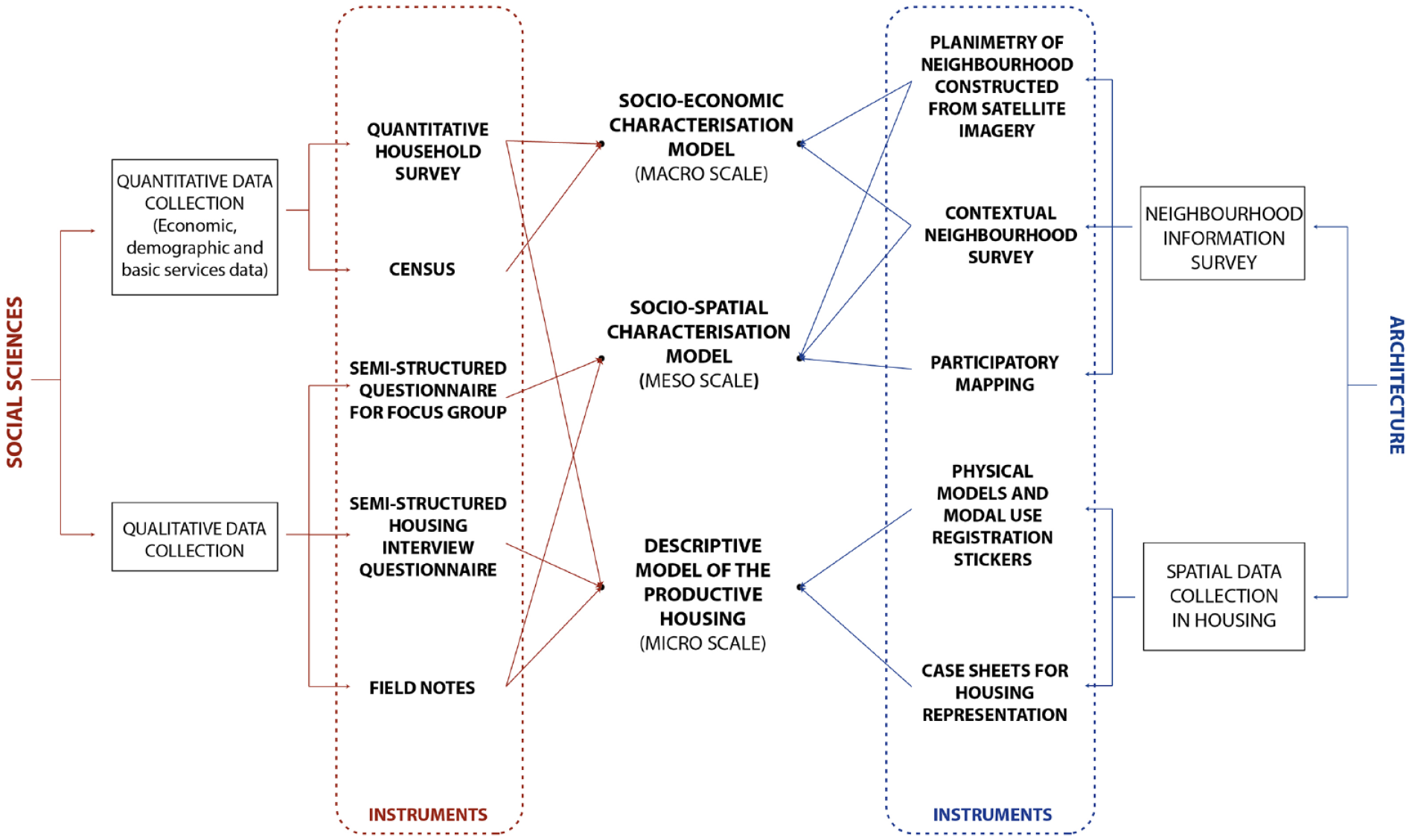
Summary diagram of the proposed interdisciplinary methodology.
On the sociological side, we used (1) a socio-economic survey to characterise some aspects of the dwelling and its members (economic, demographic and basic services aspects), complemented by (2) information from the 2017 Chilean Census; (3) a semi-structured questionnaire for families, which allowed us to know the differences in the use of domestic and productive space by gender, through the exploration of activities on the ‘most active day’ and the ‘rest day’; (4) participant observation notes, in which we recorded the main characteristics of the interviewees and their homes and (5) a semi-structured questionnaire for focus groups, in order to obtain two types of information: perceptual information (participants’ opinions about the neighbourhood) and propositional information (services, materials and social solutions that the participants would incorporate in the neighbourhood in the future).
On the architectural side, the aim of the data collection was multiple. Firstly, to gather information on the dimensions and elements that characterise the space of the productive dwellings visited. To this end, we used: (1) a laser measuring device to measure the internal dimensions of the dwelling and the plot on which it is located; (2) photographs of the objects, spaces, façades of the dwellings and their materiality; (3) freehand sketches to obtain a representation of the dwellings and their spaces; and (4) planimetry of the neighbourhood drawn with information from satellite images. Then, the data collection also sought to graphically represent the perceptions and projections of the focus group participants, based on (5) a collaborative mapping plan. Finally, (6) a maquette was created to visually capture the use of space differentiated by gender, with removable possible additions; and (7) stickers differentiated by gender, age, and domestic and/or productive activity to attach to the maquettes.
Regarding the systematisation of the information, both the content analysis of the household interviews and the focus groups followed the traditional course of social research: the audios were transcribed, grouped by codes or nodes with the help of the Nvivo software, and the results were interpreted with the support of the field notes and photographs. On the other hand, the plants and their dimensions were drawn in Autocad and Arcgis software, taking care of the details of the division of space and uses according to gender. This was complemented by the field sketches, the photographs collected and the stories told by the inhabitants, to complete the characterisation of the dwellings.
Scales of analysis
In this research we use the concepts of micro, meso and macro scale to define these scalar parameters. We refer to the micro-scale as the basic unit of analysis, in this case, the dwelling. Within this framework we seek to characterise the dynamics associated with domestic and productive uses in the dwelling, isolated from its context. An axonometric drawing is used as a means of representation, highlighting the dimensions of the spaces and situations that represent the uses. On the other hand, we refer to the meso-scale as a group of dwellings in the neighbourhood. The aim is to represent situations that are characteristic of the uses, in public spaces. In this case, the axonometric drawing describes spatial qualities and situations that are representative part of the neighbourhood. Finally, we refer to the macro-scale as the neighbourhood. In this approach we represent the sum of the individual characteristics of the dwellings and their distribution over the territory. In this case, the axonometric does not represent efficiently the data collected (socio-economic characteristics), so a map is used as the main diagram and a colour is assigned to each aspect of the analysis, making it possible to correlate the quantitative data with their spatial distribution in the neighbourhood.
These scales correspond respectively to the socio-economic characterisation model (macro), the socio-spatial characterisation model (meso) and the descriptive model of productive housing (micro). The first two allow the study of productive housing to be complemented with information on the contextual space, while the micro scale addresses specific case studies. This section is organised as follows: for each scale it indicates the content of the model, the research question that it answers, the systematic steps needed to produce the model, and the case study application. Table 1 shows a summary of the section.
Summary table of the new socio-spatial representation method.
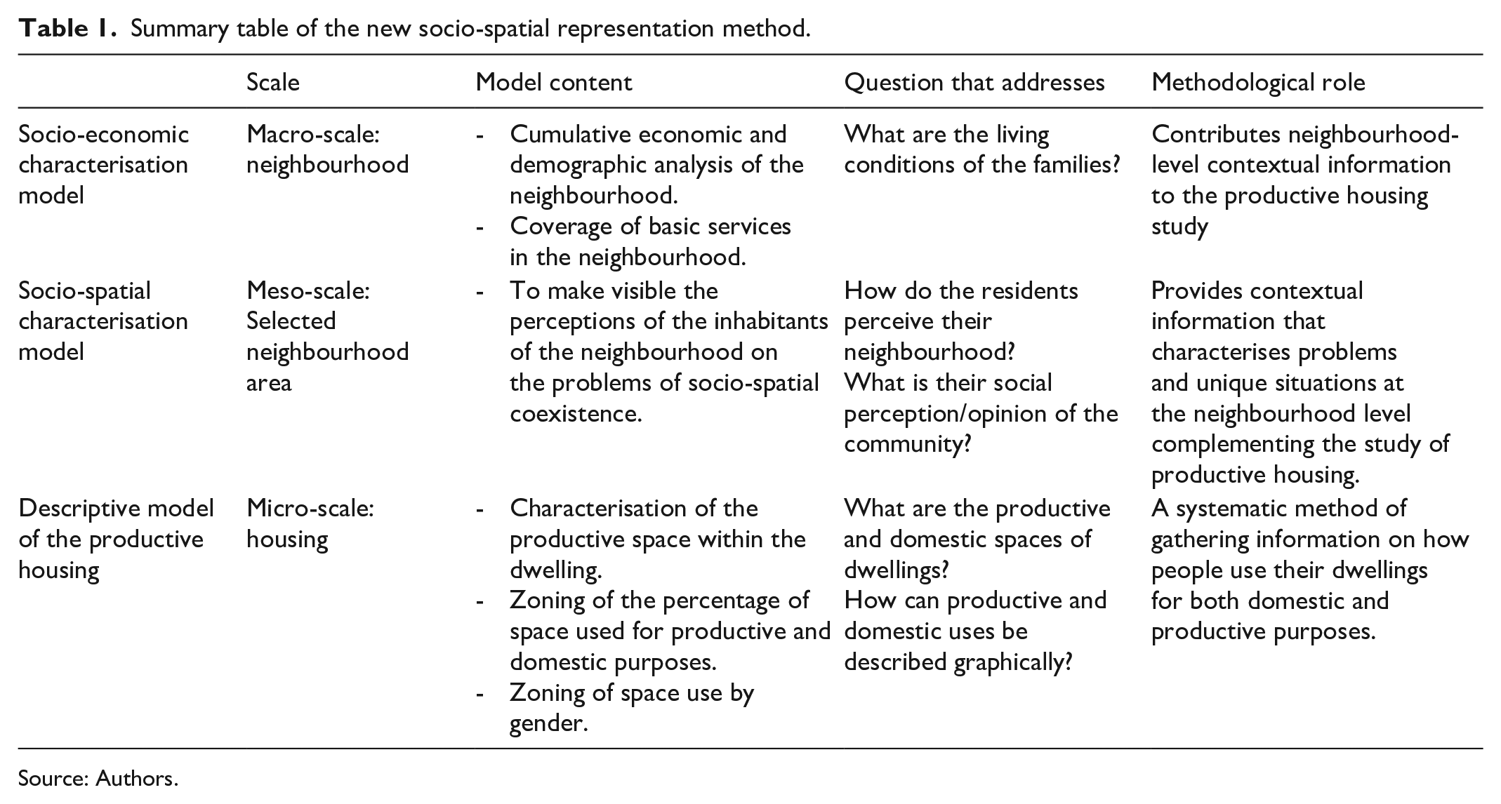
Source: Authors.
Methodological model
Socio-economic characterisation model: macro-scale
Content of the model
It represents the basic characteristics of neighbourhoods in three dimensions: demographic, economic and services. The motivation for creating a socio-economic characterisation model is to add complexity to the analysis of productive housing through its context, understanding the socio-economic composition and its spatial distribution.
Question
In addition to presenting information on the neighbourhoods, it answers the question: what are the living conditions of the families? It considers the demographic dimension (family composition), the economic dimension (productive activities) and the basic services dimension (electricity, water, etc.). In this way, it provides spatial information about the neighbourhood and describes its socio-economic characteristics.
Systematic steps
They are divided into the content and the formal standards. The first includes a characterisation, that is, a description of the demographic, economic and basic services. On the other hand, the formal standards are steps to be followed in a geographic information software (GIS), which can be summarised in three parts. Firstly, a phase of drawing and tabulating the quantitative information associated with the polygons in the map representing the characteristics; secondly, a phase of analysing and visualising the dimensions (economic, demographic and basic services) in the map; and finally, an analytical selection of the information to synthesise the variables in a single map. Figure 2 shows a diagram of the steps to build the model and the crossovers of techniques and tools from social sciences and architecture to achieve it.
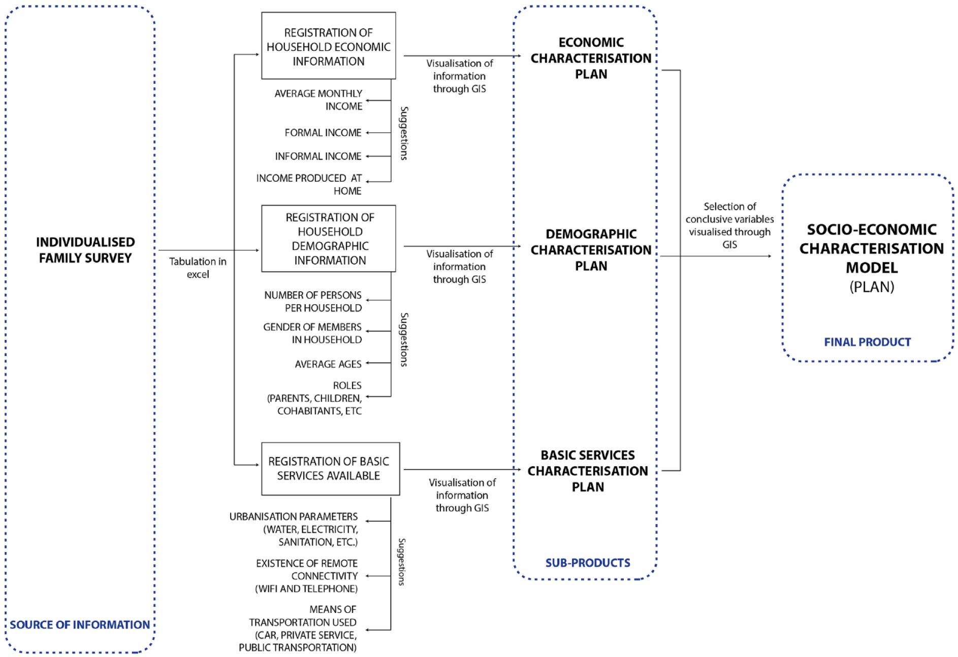
Methodological diagram of the socio-economic characterisation model: macro-scale.
Case study application
To address the macro scale of the Transitional Emergency Settlement, several data collection processes were undertaken. First, neighbourhood plans were drawn in CAD software (AutoCAD) based on Google Earth satellite imagery. During the 2022 fieldwork, socio-economic information was collected through a survey that was used at the beginning of each household interview (Figure 3). The survey collected information based on the three guiding dimensions of the model: demographic (age, roles, gender, number of people), economic (average monthly formal and informal income and income produced in the household) and basic services (availability of electricity, water, internet and transport) (Figure 4). The methodological innovation here is to provide the basic guidelines for any spatial socio-economic analysis, as the representation from a GIS model is not part of the innovation. Specifically for the study case there is no census data, so this application presents the hypothetical product that could be constructed with the data. The output has been linked to the socio-economic vulnerability domains of each location in the neighbourhood to show the advantage of the proposed dimensions for categorising a community (Figure 5).
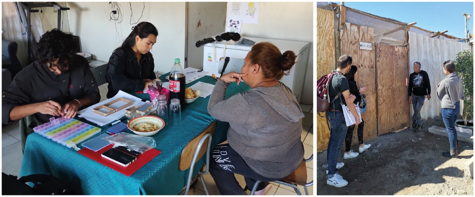
(Left) Household interview to obtain socio-economic data on dwellings (right) Interview with activist from Diego de Almagro (May 2023).
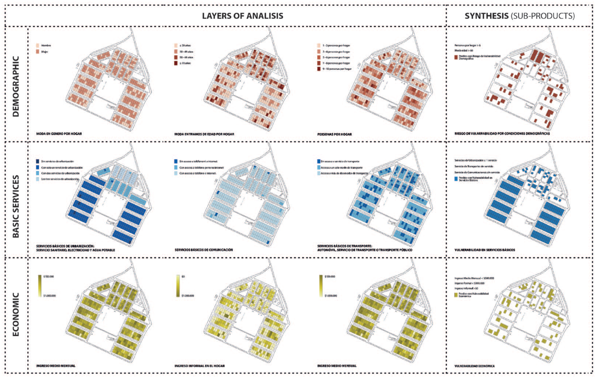
Analysis plans by socio-economic area: (red) demographic analysis, (blue) basic services analysis, (yellow) economic analysis. The last plan is highlighted as a synthesis of each analysis area.
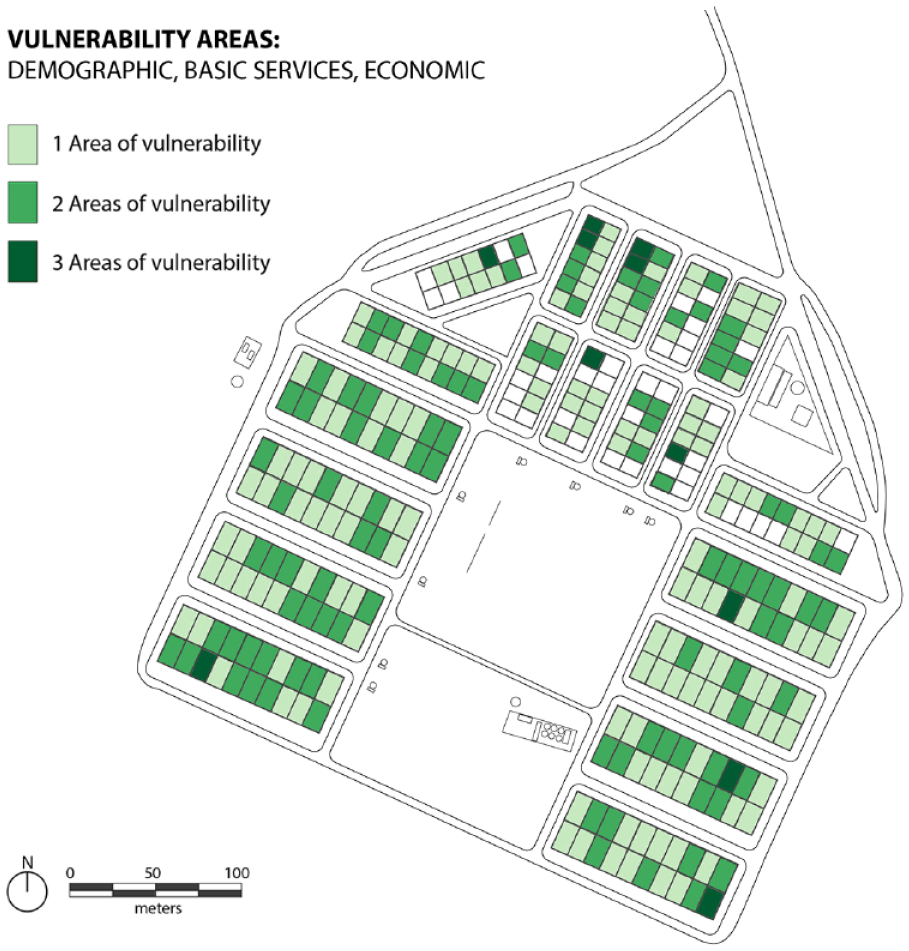
Synthesis map of socio-economic characterisation. Focused on vulnerability in relation to the proposed areas of analysis (economic, demographic and basic services).
Socio-spatial characterisation model: meso-scale
Content of the model
This model graphically represents social perceptions in relation to a given area of the neighbourhood. The approach consists of collecting and analysing focus group instances, to understand the main social problems of the communities, as well as the different points of view in relation to the space (uses, deficiencies and benefits). These problems are presented through an axonometric drawing that reflects the collective and shared dimension of a part of the neighbourhood, considering its social and spatial aspects. This characterisation makes some neighbourhood problems visible, contextualising the study of productive housing.
Question
This model seeks to answer an elusive question in the social sciences: the perceptions of a group of residents in relation to a space, problem or situation. For this research, it is very important to gather this information from the story itself, to ‘let the subaltern speak’ and not to speak for them (Spivak, 1988). Thus, the socio-spatial characterisation model seeks to describe and interpret two domains: social perceptions and spatial perceptions. In this sense, the question answered by this model is: how do residents perceive their neighbourhood and what is their social perception/opinion of the community?
Systematic steps
Focus groups are used to capture the content of the residents’ perceptions. Based on a semi-structured questionnaire, a conversation is held with the residents about their perceptions and projections of social problems and public spaces. This is accompanied by a photographic survey of public spaces, facades and the materiality of the streets. An aerial or satellite image of the neighbourhood is also included. The satellite image can be obtained using Google Earth images, and the aerial image can be obtained using a drone that creates an orthomosaic from individual images. The results of each collection technique are two: a participatory map (from the focus group transcript and the drawings on a map made with the interviewees) and a material characterisation map (from the selection of relevant public spaces, the merging of the façade photographs and the selection of materialities and the condition of the dwellings). Finally, using this information, the product of the model is an axonometric drawing representing characteristic situations of the socio-spatial context of the neighbourhood to be analysed. The methodological summary is shown in Figure 6.
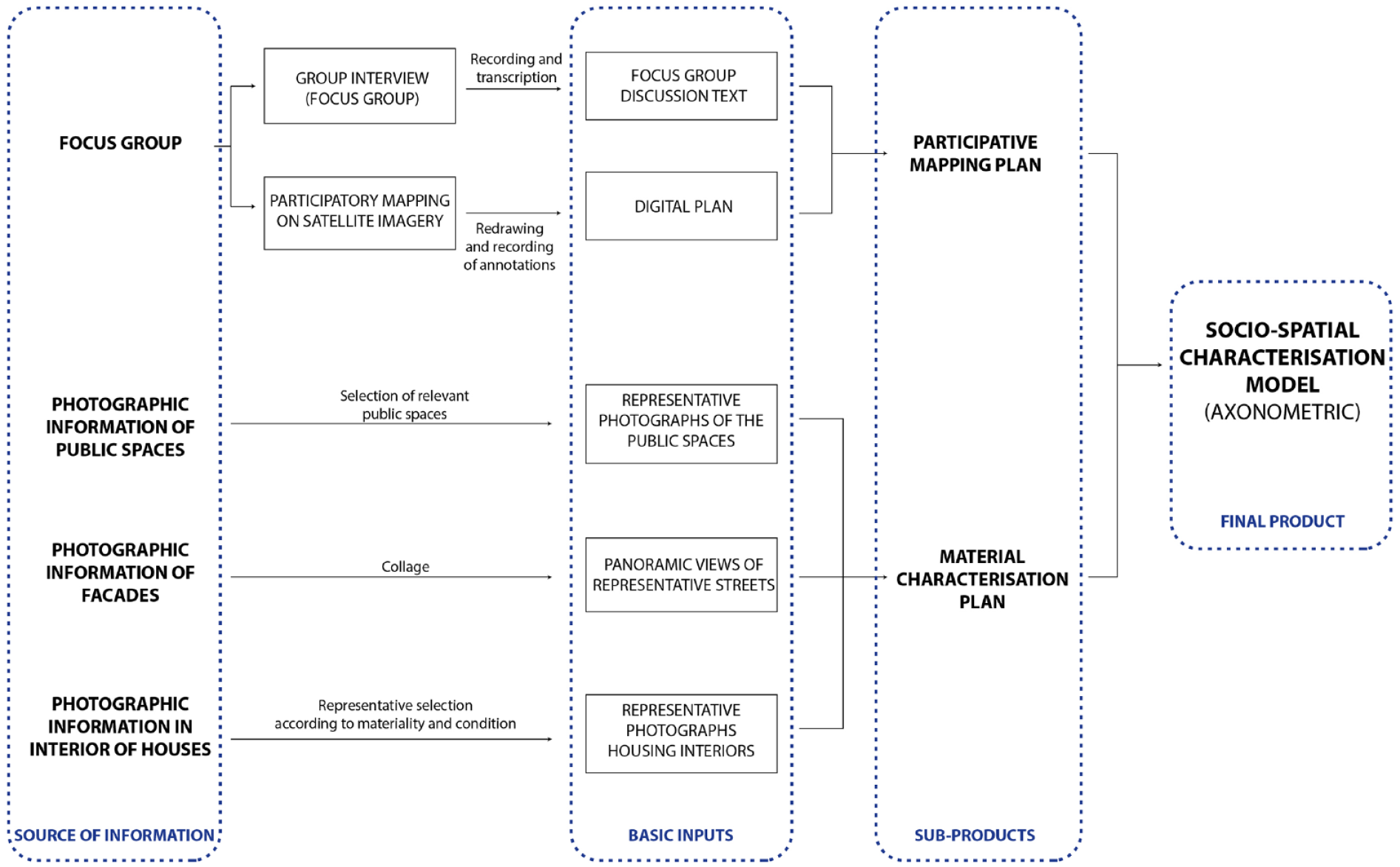
Methodological diagram of socio-spatial characterisation: mesoscale.
Case study application
To address the mesoscale, several data collection processes were undertaken. First, neighbourhood plans were drawn in CAD software (AutoCAD) based on Google Earth satellite imagery. During the fieldwork, information about the spatial practices of the inhabitants was collected through participant observation and recorded on the maps. The general organisation of the neighbourhoods was identified, with particular emphasis on the distribution of space by blocks, main streets, community centres and productive housing. This information from the fieldwork was incorporated into the CAD plans (Figure 7). In a second instance, a focus group was guided by a set of semi-structured questions to gather information about the use of the neighbourhood as described by its residents. Some of these questions required the participation of the residents, based on tracing with pencils and the use of post-it notes on maps of the neighbourhood previously drawn by the research team. The participation sessions made it possible to collect the perceptions that the residents had of the Transitional Emergency Settlement (narratives) and what they would like to improve (projective) (Figure 8). Finally, the facades of the streets in the neighbourhood were photographed, paying particular attention to the materiality and aesthetics used (Figure 9). The product of this model is an axonometric drawing of the neighbourhood, framed at the mesoscale, which allows a graphic representation of the perceptions of the inhabitants (Figure 10).
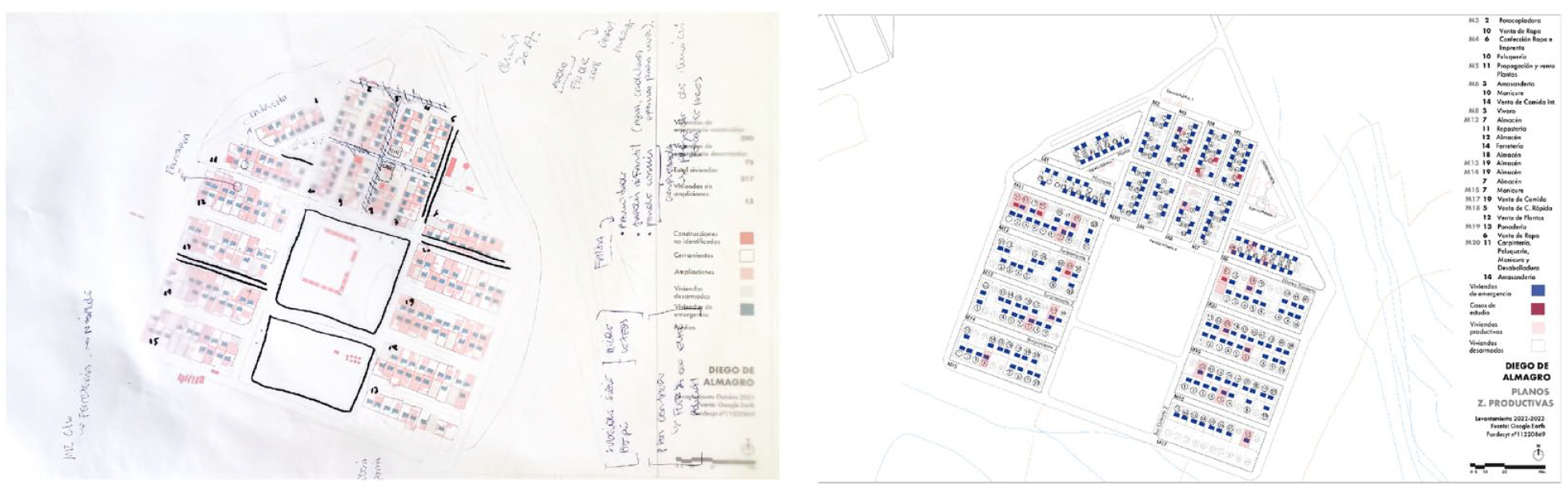
(Left) Plan intervened during fieldwork. (Right) Plan updated after fieldwork (May–June 2023).
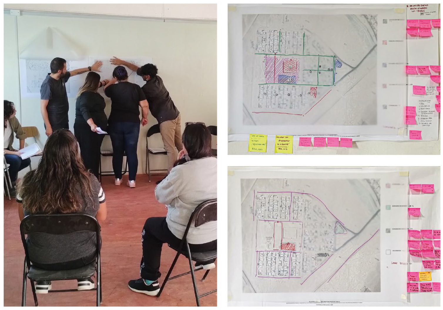
(Left) Participation during focus group (May 2023). (Right) Plans intervened during activity (both perceptive and projective).
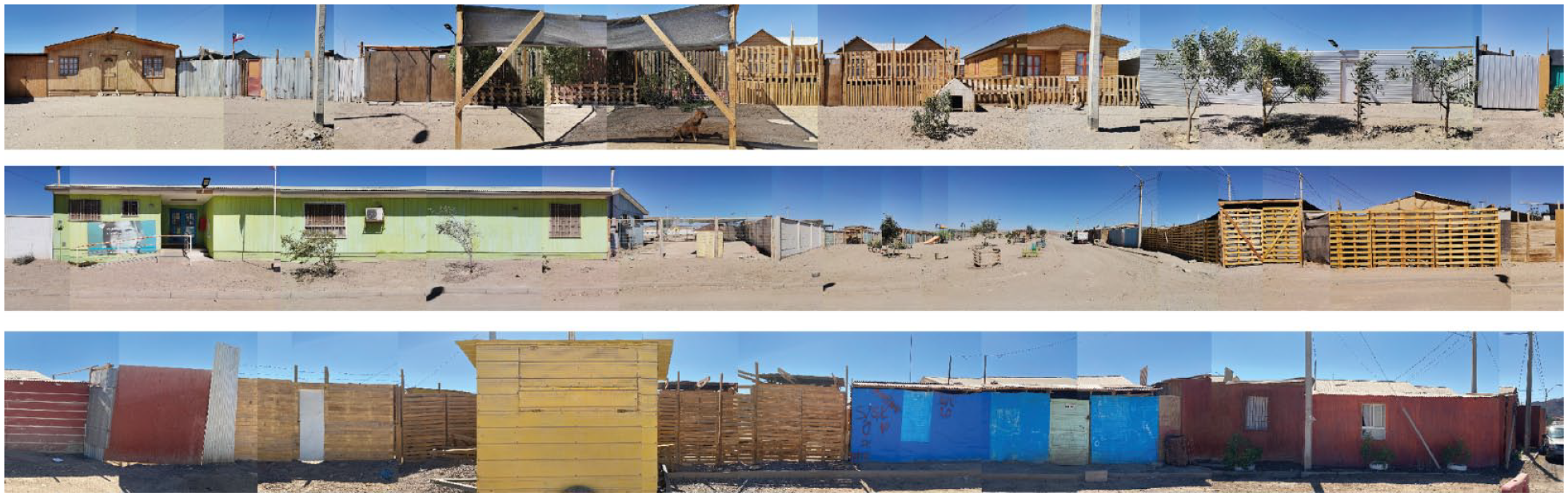
Facades in Diego de Almagro (November 2022).

Mesoscale axonometric representation of residents’ accounts of a public space in the neighbourhood.
Descriptive model of the productive housing: micro-scale
Content of the model
The third and final product of the methodology offers a representation of the dwelling, considering its productive dimension. That is, while representing the dwelling, the productive dimension is recognised in each case and translated into a delimited area. In addition, the model attempts to describe and identify the domestic and productive uses and problems. The output of the model is an axonometric drawing that characterises the productive dwelling by considering: (1) its productive space; (2) the spaces used for both productive and domestic purposes and (3) the gender, family role or any other difference in space use.
Question
The aim of this product is to graphically represent the spatial characteristics of domestic and productive uses, based on the information collected in the interviews. This model therefore answers the questions: What are the productive and domestic spaces of the emergency houses? and how can productive and domestic uses be described graphically? In doing so, it seeks to represent the different dimensions of economically productive housing and to show its most characteristic elements.
Systematic steps
This model is based on three tools: interviews, spatial data and photographs of the dwellings. The interview is accompanied by the collection of spatial characteristics through maquettes and stickers. The stickers differentiate the domestic and productive use of the spaces, as well as gender and age. In parallel, the spatial dimensions of the dwelling are recorded on an observation sheet together with a sketch of the dwelling. Finally, two priority elements are photographed: the material state of the dwelling, the productive spaces and its furniture. The result of the collection techniques is a plan showing the domestic and productive uses by gender and age. Finally, the output of the model is an axonometric drawing that represents the relationships between domestic and productive spaces and gender. Figure 11 shows the methodological summary of the model.
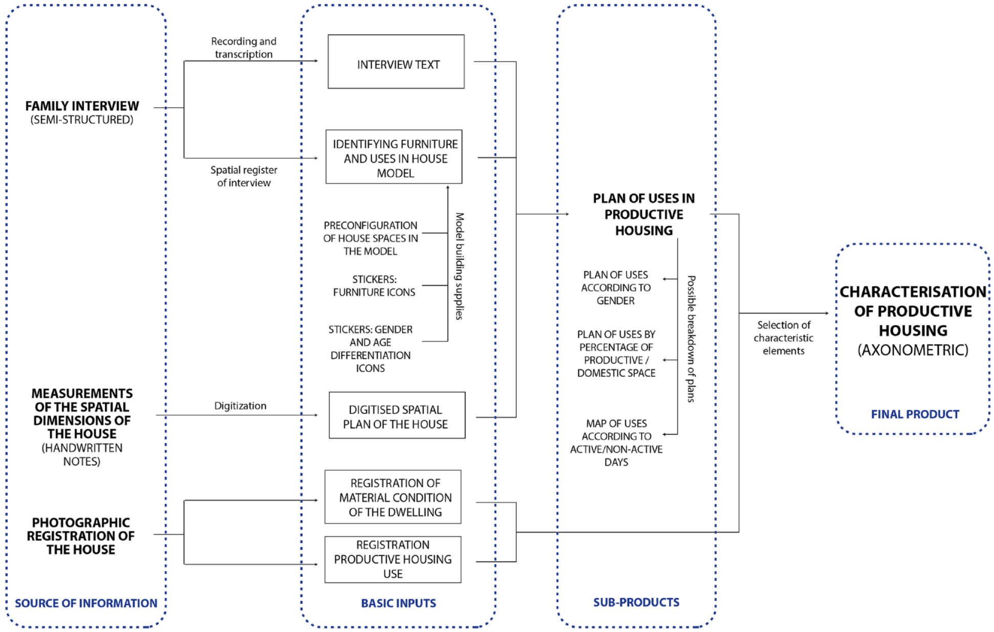
Methodological diagram of the descriptive model of productive housing: micro-scale.
Case study application
Semi-structured interviews were conducted to address the micro level. The interviews sought to explore the daily routines of the residents, the use of domestic space and the intersections with productive activities within the dwelling. At the same time, different methods were used to spatially represent the individual stories. Domestic and productive uses were recorded using a physical model (maquette) that represented the temporary dwelling provided by the government and the extensions made by the residents. The maquettes were made beforehand by the architectural team based on the typologies of the dwellings from satellite information. This made it possible to collect spatial information on domestic and productive uses during the interviews and to explore how the participants ‘inhabit’ the space. Specifically, the following steps were taken to collect spatial information: (1) use of physical models in a participatory manner during the interview; (2) collection of information on the internal distribution of rooms, furniture, domestic and productive uses, uses by gender using pre-defined stickers on the physical models (Figures 12 and 13) and (3) drawing of the collected information in the physical models using CAD software, supported by the interview transcripts. During the interview, plans of the dwellings were drawn with their actual dimensions, based on visual analysis, measurement and representation by hand drawing (Figure 14). Finally, photographs of the dwellings were taken (interior and exterior), with particular emphasis on capturing the use of productive spaces in and around the house (Figure 15). The result is an axonometric of the dwelling, showing the spatial relationships between emergency shelters, extensions and gendered uses of productive and domestic space (Figure 16).
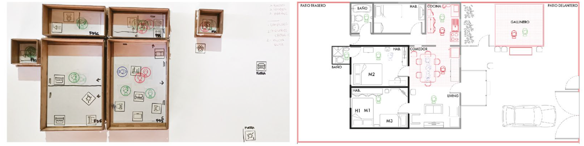
(Left) use of the dwelling data – physical model. (Right) drawing of the information from the physical model (maquette).
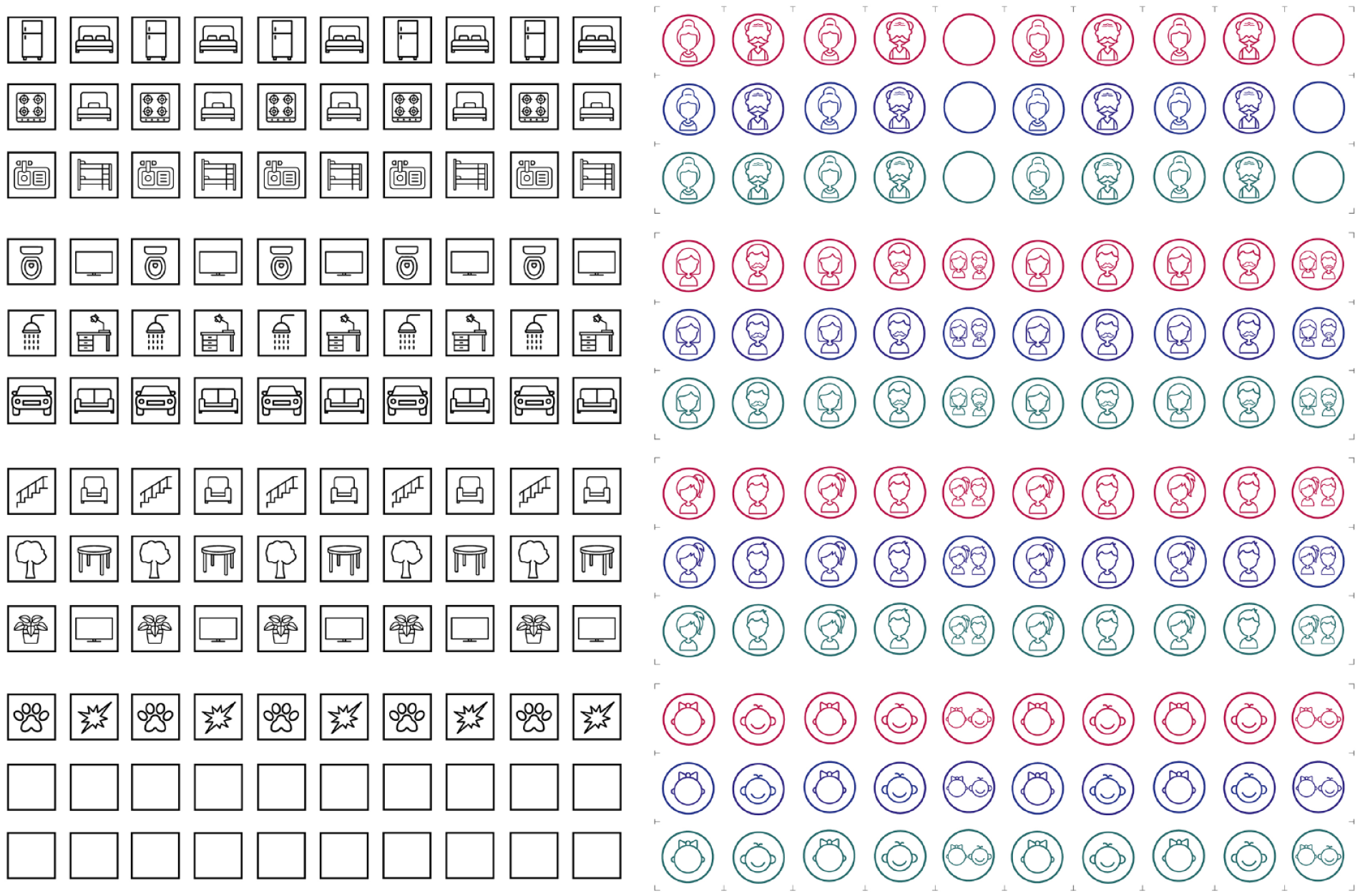
(Left) Household furniture stickers. (Right) Gender and type of activity stickers (red: productive. blue: non-productive. green: housework).
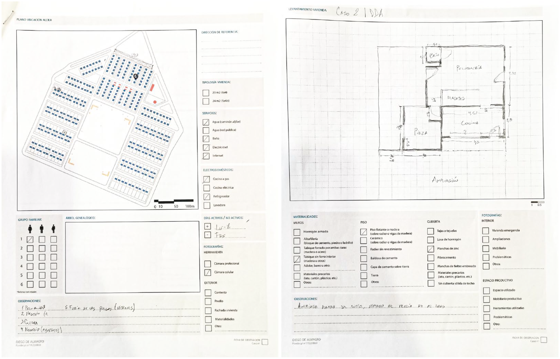
(Left) Sheet part 1. Map of house location, household and observations. (Right) Sheet part 2. Plan of the house (sketch) and materials (May–June 2023).
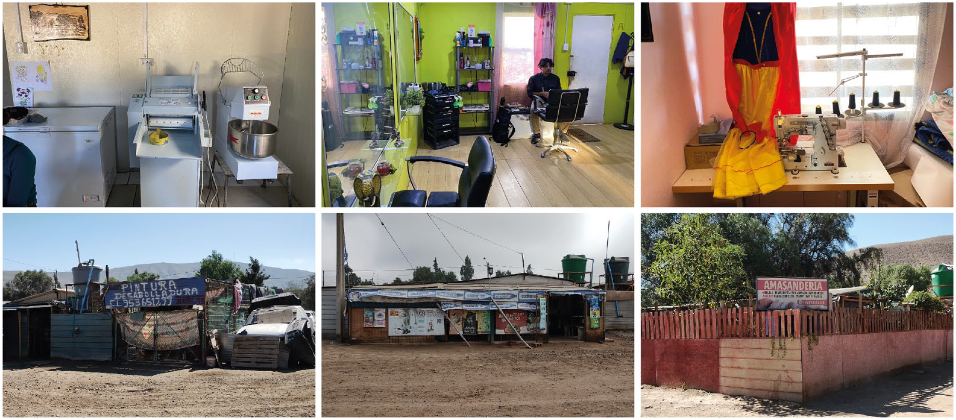
Photographs of dwellings: domestic and productive spaces. (Top from left to right) Bakery tools inside the dwelling, hairdressing room inside the dwelling, dressmaker’s tools inside the dwelling. (Bottom from left to right) car repair shop, shop, bakery.
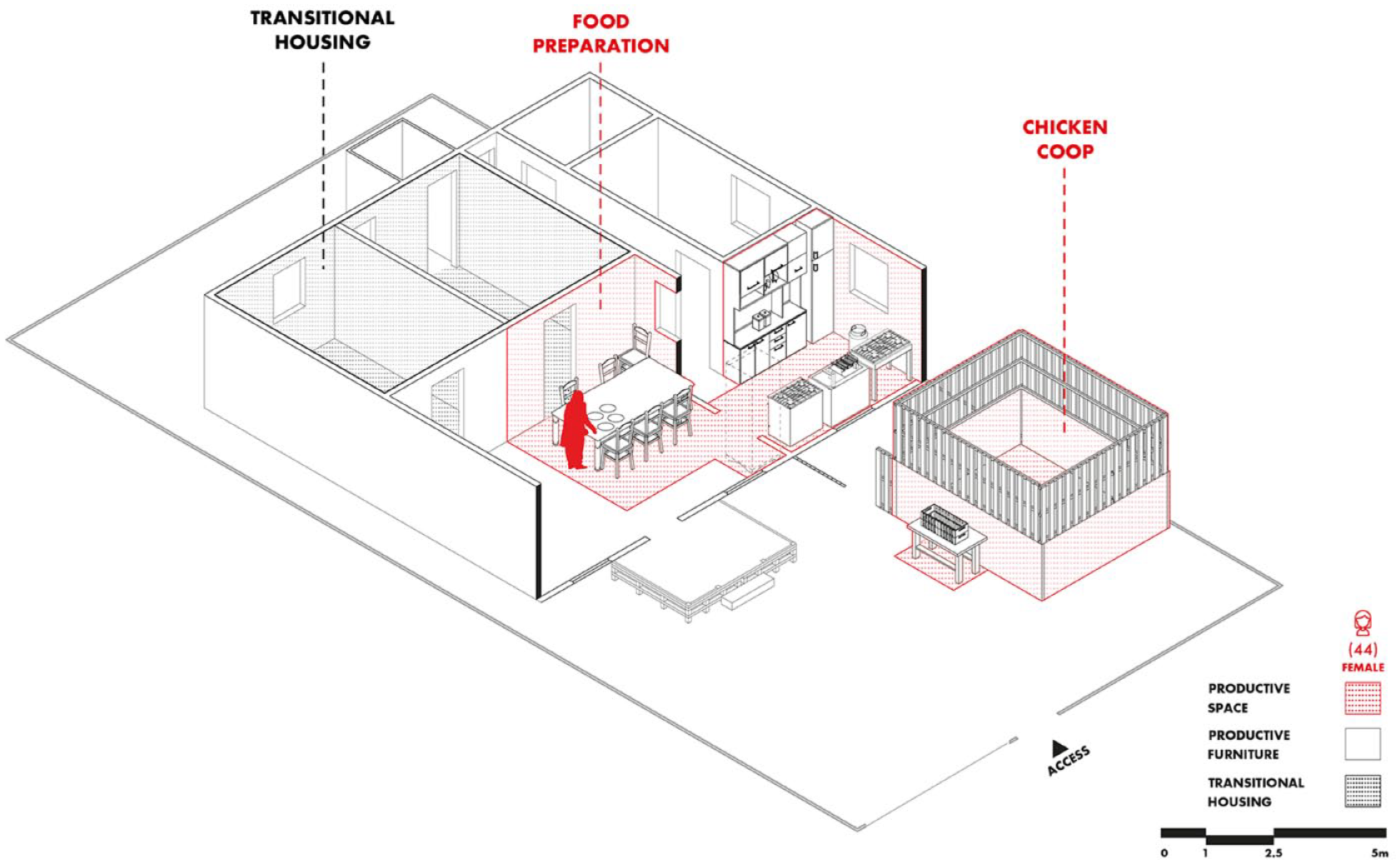
Axonometric of the microscale (productive housing). It shows spatial relationships between emergency housing, extensions and gendered use of productive space and domestic space.
Key innovations: a brief discussion
The article's primary aim was to methodically explore the connection between domestic and productive space in the aftermath of climate disasters and recovery efforts. It sought to display the intricate nature of this bond, particularly in the context of emergency housing, which in most cases double as productive housing. The research showcased the various applications of the shelter’s internal space in both domestic and productive settings. The study also aimed to illustrate the gendered use of spaces.
At the beginning of this paper, we discussed the different approaches to ethnography and visual methods, including their corresponding techniques, at the outset of this paper. We have confirmed that there is a gap in analytical approaches that explore the relationships between productive and domestic spaces, including their conflicts, overlaps and gendered discontinuities. Therefore, there is a need to develop methodologies that bridge this gap and provide a comprehensive understanding of the issue. In this regard, we have embraced Pauwels’ (2010) challenge to develop a coherent methodological framework that integrates visual methods and other disciplines for the focused study of housing, and in particular, home-based work.
As mentioned above, the data collection was a joint approach by sociologists and architects, using the techniques of each discipline in conjunction. The main innovations relate to the collection of data at the micro and the meso scale. To collect as much information as possible on the productive and domestic use of the selected dwellings, we thought of a research tool that would allow us to collect the information narrated by the interviewees during the interview, but in a visual way. Thus, our tool consisted of maquettes corresponding to the dimensions of the emergency dwellings (18–24 m2) and their possible extensions over time. At the beginning of the interview, we informed each interviewee that we would be collecting information about the use of the spaces visually. In each case, the interviewees could participate in this collection, as part of the consolidated research tool also included a set of stickers representing material and immaterial actors in the dwelling. By material actors, we mean all the stickers in the form of pictures representing objects and furniture of a dwelling, such as beds, kitchens, stairs, bathrooms, showers, tables and chairs, trees, among others. By immaterial actors, we mean all the stickers in the form of a circle representing demographic characteristics, where (i) age was represented by a different icon for each age group (childhood: 0–10; youth: 11–21; adulthood: 22–59; elderly: 60+); (ii) gender was represented by traditional male/female icons, plus an icon with both genders for the case of ‘non-binary’ (although there were no cases of this classification); and the distinction between activities was based on colours (red for productive activities, green for domestic activities and blue for leisure or recreational activities).
In this way, the maquette was presented to each interviewee, and the application of the semi-structured interview began, guiding the conversation and maintaining the objective of collecting the main differences in the use of space, based on the distinction between productive, domestic and recreational activities. Simultaneously, the interviewees could observe that the story was visually collected in the physical model (maquette), and that the activities were recorded with the stickers. Subsequently, once all the possible data had been collected, the information was recorded on transparent layers, which allowed the information to be differentiated according to the least productive day and the most productive day. This distinction was relevant because it functions as the ‘filter question’ at the beginning of the questionnaire, which allows us to know the days of more productive work inside the dwelling and the days of more family rest. For this reason, the information is recorded on transparent layers, which in the subsequent analysis allowed us to digitise all the information and analyse it together with the recording of the interviews and the field notes, bringing together the observations of the users and their stories about the use of the spaces.
The approach serves as a prime demonstration of the convergence of social and architectural techniques that merge in the interview setting. Our novel data collection method facilitates a harmonisation between the interview anecdote and the fixed representation of the planimetries. This method, as previously stated, avoids a subjective and all-encompassing view of reality and instead enables us to examine productive housing as a study object from diverse perspectives, incorporating both social and architectural observations. The tool of ‘maquettes and stickers’ furthermore allows gathering gender-differentiated data, a key concern of this study. As previously mentioned, the issue of gender becomes apparent when examining the housing sector, in which women have traditionally been marginalised. By adopting this approach, we were able to investigate the gendered division of labour regarding certain activities, without making any assumptions about each group’s domestic or productive roles. It is crucial to acknowledge that historically, women have predominantly undertaken domestic work. Despite this, we queried the domestic, productive or recreational activities of all dwelling inhabitants and subsequently deduced our findings based on the obtained results. This enabled us to make a valuable comparison between spaces that exhibit a greater female presence and those with a greater male presence. The comparison and survey results are outlined in the ‘productive housing model’.
Although the proposed model proposes three scales of approach to the study of housing, the macro and meso scales are focused on collecting and making visible contextual information that can help analyse the phenomena studied within the domestic space. Thus, the model focuses on the study of the micro scale, related to housing, in which the mixture of traditional social science analysis is complemented by spatial visualisation tools from architecture. The incorporation of spatial data collection tools and representation methods for the study of productive housing, on the one hand, contributes to visually communicate the results gathered by the social sciences and describe them in space, displaying information complemented with the measurements of the place. This display of information can be drawn in plan; however, the use of axonometric drawing is proposed to add spatial data in three dimensions (Figure 17). This way of representing the dwelling allows for the spatial characterisation of the conclusions derived from the study of data collected with tools from the social sciences, field notes, photography, among others, giving greater complexity to the analysis of the inhabited space.
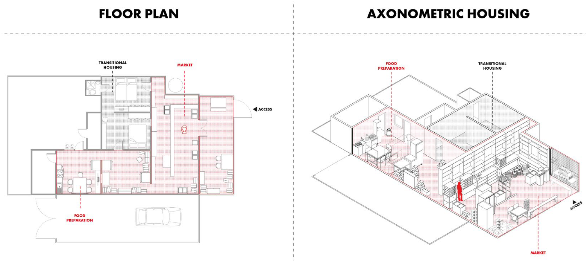
Comparison between the analysis of a case study of productive housing in Diego de Almagro presented in plan (left) and in axonometric (right), allowing in the second one, to make the characterisation of the housing more complex.
On the other hand, the use of a proportional representation of the dwelling allows the overlapping of layers of information, always including the spatial context associated with them (Figure 18). This is important because, since the object of study is ‘housing’ as a space of social relations that is transformed and inhabited, the way in which this physical space is configured becomes relevant. Thus, using the axonometric representation to characterise productive housing makes visible not only the static data that is measured (e.g. leisure space vs productive space), but also the way it is expressed in space (i.e. distribution of furniture, disorder, space for storing inputs and use during different days). This allows us to understand more complex information in terms of the area in which uses are expressed and the way in which they are distributed in space. In this way, the analysis of information expressed in space in three dimensions can include a comparison between leisure and productive space; or areas used by different genders or ages, overlaying variables that are visible in a less abstract way than data in a graph.
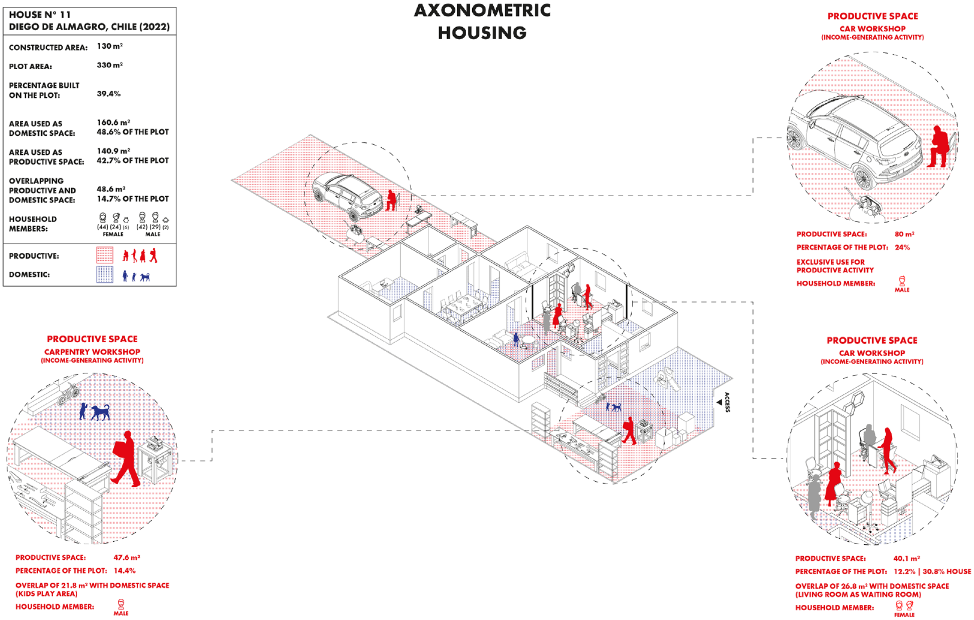
Productive dwelling, presented in axonometric form, which allows different levels of analysis: area dedicated to economic activities, different elements/furnishings used in the economic activities developed in the house, gender of the person using the productive areas and spatial characterisation of these areas.
Conclusion
The aim of this article was to provide a methodological framework for the study of productive housing, particularly in emergency and disaster contexts. The main methodological innovations focused on the description and testing of new data collection tools and the visual representation of space that can be achieved through axonometric drawings. Here we present the spatial characteristics of productive housing in relation to three fundamental insights that we might consider essential, namely (1) the distinction between productive and domestic spaces; (2) the gendered use of these spaces and (3) the overlap between domestic and productive spaces and activities.
These characteristics, which are crucial for the study of the productive housing unit, show that the distribution and use of spaces in productive houses is overlapping, challenging the traditional concept of housing and showing how this dispute allows the creation of the concept of productive housing, as well as an appropriate methodological framework for its study and analysis. In this sense, in addition to consolidating the working hypothesis, the question of how to represent the complexity of the relationships between domestic and productive space in dwellings has been approached from three different approaches (micro, meso and macro), thus configuring a detailed framework of analysis for this field of study (home-based work). After applying the method, we found some advantages and limitations of our new method, which are explained below:
Advantages
Limitations
Future guidelines
The Socio-Spatial Representation Method has allowed us to reflect on its possible applications and modifications. Future directions include the possibility of incorporating into the model ways of recording changes in a temporary shelter or neighbourhood over time. That is, to find ways to study ‘household trajectories’ and observe their evolution over time. On the other hand, the application of the methodology in the Transitional Emergency Settlements in Atacama has allowed us to test the advantages and limitations of the proposal, so that we have the possibility of demonstrating the applicability of the method in other areas of study. This applicability must have housing as the basic unit of analysis as ‘productive housing’, since, as we have discussed, visual methodologies and urban sociology already contribute greatly and with an optimal scope to the analysis of housing as such.
This method can be used in different domains. We propose, for example, the case of productive housing in the context of pandemics. Recent research derived from the problems of confinement shows how housing ends up being a productive and domestic space at the same time, extending this structure to the present day. Another area in which productive housing can be analysed is in collective social housing. There, productive housing can contribute to the social cohesion of a neighbourhood which is usually determined by the scarcity of family resources. Finally, climatic disasters are becoming more frequent, so updated guidelines are needed to ensure that emergency housing includes the potential to provide means for economic recovery and to function as productive housing. This is relevant in the context of recovery, as it allows for greater autonomy for affected families.
Footnotes
Acknowledgements
The authors would like to thank Francisca Cortínez for her work during the first year of the project and for her invaluable insights during the initial fieldwork in Atacama. We would also like to thank Fernanda Zúñiga, Clemente Galaz e Isadora Pizarro for their work in transcribing the interviews and focus groups. Finally, we would like to thank the communities of Diego de Almagro and Nantoco (Tierra Amarilla) for sharing their perceptions of the neighbourhood, and the families who allowed us to enter their homes to conduct this research.
Declaration of conflicting interests
The author(s) declared no potential conflicts of interest with respect to the research, authorship and/or publication of this article.
Funding
The author(s) disclosed receipt of the following financial support for the research, authorship and/or publication of this article: This work was funded by ANID – Fondecyt Iniciación N.11220869 ‘Relaciones entre espacio doméstico y espacio de trabajo. Actividades económico-productivas en viviendas de emergencia después del evento hidrometeorológico de 2015 en Atacama’, P.I. Elizabeth Wagemann.