
Abstract
A new generation of environmental satellites, the Sentinels, has recently been launched by the European Space Agency (ESA). Part of ESA’s Copernicus Programme, the sentinel mission has adopted an Open Data policy which intends to make different levels of data freely available via an online data hub. Sentinel data will support applications including land monitoring, emergency management and security and will thus form the evidence-base for a wide-range of local, regional, national and international decisions, from individual insurance claims to humanitarian interventions. By providing ever more data streams for monitoring and managing the planet, the sentinels institute a novel mode of visibility in terms of resolution, coverage and frequency. At the same time, they are co-constitutive of the increasing datafication of the environment. In the entwinement of heavenly gaze and data visions, I want to recover the work of ‘data fictions’ in order to demystify notions of visibility and calculability associated with “earth observation” and trouble its unquestioned pursuit of total monitoring.
Dear database
How to address Big Data infrastructure? How to figure agency, recover subjectivities and disclose a space of contestation in environmental data streams? In 2008 a number of disgruntled mycologists demonstrated how an open letter to GenBank, the world’s largest DNA/RNA database, might be a good start (Bidartondo, 2008). The issue that prompted it was (and remains) that many of the database records for fungal sequences were erroneously annotated, that is, the contextual information which ensures the intelligibility of sequence data was inadequate. 1 The signatories suggested the introduction of open, collective annotation and while this demand has not been met, the letter proved surprisingly efficient in other ways: It garnered an irate response from GenBank’s host institution, the National Center for Biotechnology Information, elicited an editorial in Science as well as comments from a number of prominent scientists and caused widespread debate about opening Big Data resources for community editing.
The letter thus occasioned somewhat of an ‘infrastructural inversion’ (Bowker and Star, 1999), a moment in which infrastructural matters are compelled to come to the fore. In relation to climate data Edwards (2010) has shown how such inversions can take the form of what he calls ‘data frictions’, the resistance which arises from the habitual unpacking and re-packaging of data as they travel across communities and platforms (see also Leonelli, 2009). I would contend that inversions and frictions also reveal something about the data fictions that allow this trajectory to cohere within infrastructures, and importantly, across interfaces, domains and communities of practice. During a recent workshop of the European Group on Earth Observations (GEO), a central struggle appeared to be the articulation of a consensual imagination capable not only of reconciling different types of data but of turning a corollary of issues (poverty, sustainability, public health, food security, etc.) thinkable and doable primarily through environmental Big Data. 2
And so it is with regard to data fictions that I find the open letter to GenBank such an instructive episode. The letter, a narrative device, variously discloses and occasions protagonists, histories, materials, interests and so prepares the ground for novel or other problematisations (in this case conflicting understandings of ‘openness’). 3 In other words, it helps ‘unearth the dramas inherent’ in data infrastructure (Bowker and Star, 1999: 377). Data fictions articulate and organise and at times trouble the imaginaries that instruct the production, processing and distribution of data. Methodologically, this compels discussions about ‘making data global’ (Edwards, 2010) to encompass questions related to the workings and purchase of genre, convention, sensitivity, aesthetic and rhetoric and invites a ‘diffractive’ (Haraway, 1992) engagement that reads data through its fictions. Because the ease with which satellites have become sensible guardians of the environment tends to obscure questions about the complexities, the labours and the differential visions effected by environmental Big Data.
Environmental data fictions
In 2014, the European Space Agency (ESA) launched ‘a new family of missions’ entitled Sentinels in order to support the work of Copernicus, Europe’s earth observation programme (formerly known as the Global Monitoring for Environment and Security). The sentinels will total 20 satellites, which will fly in constellation (as ‘twins’) allowing more frequent revisits and the creation of near real-time data (Showstack, 2014). Two sentinel satellites have already been launched from Europe’s spaceport in Kourou, French Guiana (on 3 April 2014 and 23 June 2015, respectively): Sentinel-1A, a high-resolution radar imaging mission with a 5 -m ground range resolution, and Sentinel-2A, a high-resolution optical mission with a spatial resolution from 10 to 60 m. Sentinel-1s will provide observations for applications covering ocean, seas and polar areas including oil spill monitoring, sea-ice monitoring, ship traffic and routing, as well as for land applications including emergency responses and security. Sentinel-2s focuses on land observations such as land cover and usage while also monitoring inland water and coastal zones, similarly providing data for emergency and security services. In short, the sentinels’ objective is ‘to manage the environment effectively and help respond to the challenges of global change’ (ESA, 2015: 2).
The ceaseless gaze of the new sentinels purports to put eyes on the environment as it encompasses all land and coastal areas between latitudes 84° north and 56° south, from beyond the tip of Greenland to just beyond the southernmost point of Chile. It covers all islands greater than 100 km2, all islands in the European Union, all within 20 km of a coastline, the entire Mediterranean Sea and all inland water bodies and closed seas. Specifically, the sentinel flies over and scans an area acquiring a continuous image that is referred to as a ‘datatake’. The maximum length of a datatake is 15,000 km (from Lisbon, Portugal to Vanimo, Papua New Guinea). Because it is not possible for a single earth observation station to cover this, so-called datastrips, portions covering 5,000 km of the image, are downlinked to ground stations. These datastrips form the basis for the Copernicus programme’s environmental data. Data are provided on three levels from 0 to 2 where 0 means unprocessed instrument and payload data (at full resolution) and 2 indicating refined measures such as surface wind speed. Data for Sentinel-1A and Sentinel-2A are already available through the Sentinel Data Hub portal at scihub.copernicus.eu. The data hub gives access to what one commentator has termed, perhaps not so coincidentally, a ‘data explosion’ as well as an ‘enormous dump of free data’ (Amos, 2014). It thus continues the decisive development of open remote-sensing (RS) data that began in 2008 when the US Geological Survey’s Landsat program (ongoing since 1972) made their data available for free download. 4
Evidently then, the basis for effective environmental management is an enormous continuous stream of near real-time RS data. Sentinel-1s and Sentinel-2s alone will provide about 3.4 terabytes of data per day, which will be instantaneously downlinked to ground stations before being released between 2 and 12 h from sensing. Most of the data will be made available on an open and free basis online (with some security exceptions). In terms of coverage, data volume and data dissemination, the sentinels represent a ‘new era in earth observation’ (Showstack, 2014). And all this is, ‘literally, (…) for the benefit of mankind’, according to Josef Aschbacher, who is responsible for coordinating ESA’s earth observation programme (quoted Showstack, 2014). 5 Advocates for the sentinels and earth observation are adamant that the environment can and should be made intelligible principally through Big Data produced by extremely expensive artefacts that orbit the earth at a distance of approximately 786 km (Sentinel-2s, 693 km for Sentinel-1s). 6
If satellites (and the environmental data they generate) are the answer to environmental crises, then we might do well to consider how this entrenches the question of how best to address environmental change. To put it differently, what is the shape and form of crisis if the primary response impels the environment to become ‘utterly absorbed into data and data space, a digital ghost in the machine’ (Waldby, 2000: 7)? One possible figuration is that of war, which also provides an answer to the question of how satellites got there in the first place. Whether in the description of the Landsat programme as ‘civilian’, the stress on strategic measures and ‘combating’ environmental challenges, or the drive for ever more penetrating and panoptic vision, environmental Big Data can appear close to the rhetoric of warfare. Yet in contrast to much environmental ruination war is infinitely more sensible in that it has present effects and follows recognisable conventions (e.g. soldiers, military hardware, bombings). That one can at least grasp the condition of war and thus comprehend it through an established set of fears, expectations and knowledges emerges as a central argument in the accounts of the people of Chernobyl recorded by Svetlana Alexievich (2016 [1997]). What, however, escapes the senses, comprehension and imagination is (radioactive) pollution and the long-term or far-away effects of environmental degradations.
Artful accounting
Sentinels account for the environment by observing, measuring and modelling earth surface characteristics. In relation to terrestrial sensing, these characteristics are indicative of different types of land cover formed by biophysical and biochemical patterns resulting from the interaction of biotic and abiotic factors including humans, climate, geology, soils, animals, fungi and plants. Parameters measured are, for example, leaf area index, chlorophyll and nitrogen as well as spectral products like ‘red edge’ position and the normalised difference vegetation index (NDVI), an index of photosynthetic activity. None of this is captured directly. Instead theories and models from one phenomenon such as reflectance or radiance are extended into theories and models of another phenomenon such as chlorophyll production (Lein, 2012: 45). What counts as real or virtual (manufactured based on model simulations) observation though remains a critical uncertainty in the pursuit of Big Data environmental science (e.g. Beven et al., 2012).
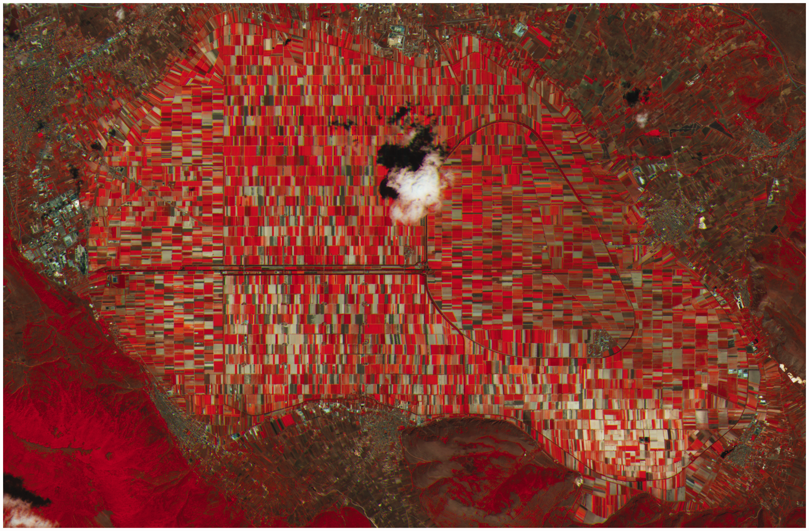
‘Is it a piece of art or a satellite image?’ the Copernicus website asks of an image (Figure 1) produced by Sentinel-2A. An article in The New Scientist discussing the same image asserts that ‘Gustav Klimt would like it’ (Firth, 2016). Looking at Figure 1 one is certainly persuaded to appreciate it aesthetically: a pretty mosaic of red, grey and black tiles. The caption, however, makes clear that this is not Jugendstil art but agricultural fields in Italy’s Fucino valley imaged in false colour (here showing the ‘red edge’ where plants and chlorophyll show in different red tones). The picture, then, is both art and satellite image and while such equivocacy highlights the instrumental combination of imaging and knowing (e.g. Daston and Galison, 2007), it also troubles the logic according to which visibility, legibility and calculability connect and proceed. It is not a matter of course that sensors apprehend digital numbers and pixel values beget data, which in turn become images that are commensurable with environments. Sentinel data requires continuous and habitual inverting: A recorded observation has to ‘be translated into numerical terms before it can be realised as data’ (Lein, 2012: 45).
For Waldby, the digital ghost (in her case, the human body) problematises any neat distinctions between the virtual and the real for it demonstrates how issues such as sex and ‘race’ become re-materialized via data. Similarly, the picture of the Fucino Valley is not quite real, nor entirely virtual. It is hard to tell what might have gone astray on the convoluted and laborious path of data processing: from dark signal and crosstalk correction, defective pixel restoration, de-convolution and de-noising, re-sampling and imagery compression to further resampling, orthorectification, masks computation and additional imagery compression. The picture is more of a vision than a clear-cut observation. Yet consequential data fictions are being woven that can, in the case of the Fucino valley, sensibly contain and relate RS observations, biomass proxies, crop yield and acreage, per capita food demand, gross domestic product or population statistics. Thus transformed into so-called ‘agricultural intelligence’ (e.g. Atzberger, 2013), remote-sensed crop monitoring can (and indeed, has) become a staple in narrating the politics (and infrastructures) of food security. But there is a lot which escapes sentinels: migrant workers and labour relations, types of fertiliser and pesticides used (and their long-term environmental and public health effects), agricultural subsidies, futures traded on crop forecasts, or mycorrhizal entanglements. These omissions are not only due to technical limitations but also connected to limited imaginations about Big Data and environmental crises. How do we read an image like the one shown above? What, with reference to Waldby, are the constitutive dynamics between the real and the virtual and how can we grasp the similarities and differences that matter?
Sentinel-2A false colour image of Fucino Valley, Avezzano, Italy. Copyright Copernicus Sentinel data (2015)/European Space Agency (ESA). From url: https://archive.org/details/calligrammespo00apol (poem on p. 168))
7
.

The sentinels
COME IN THE SOW The sentinel with the long gaze The sentinel with the long gaze And the dugout was called THE TRANQUIL CENOBITES The sentinel with the long gaze the sentinel with the lingering gaze Come in the sow Guillaume Apollinaire, “Cotton in your Ears”, 1918
Apollinaire’s poem “Cotton in your ears” takes us into the trenches of World War I where the sentinel cuts an odd figure. The poem, part of his Calligrammes: Poems of Peace and War 1913–1916 (1980) collection, begins with an explosion accompanied by words set unto the page like artillery fire. On the poem’s second page, things have calmed as the letters settle into their grid until the shout of “Come in the sow” (perhaps a call sign bellowed into a field telephone), all caps. It is then that the sentinel makes his first appearance. Senses stifled by the crashing and the screaming, still his gaze remains fixed on the adversary, enduringly unfazed. He is only interrupted by the strange sign informing us of this particular dug-out’s name (‘the tranquil cenobites’) before returning once more with his gaze long and lingering. The repetition of sentinel might not refer to the same but to more of the same indicating the steady replacement of parts obliterated by war. The sentinel here is both witness and guard in the midst of a type of warfare that remote sensing technology, with its ‘surgical’ gaze, is supposed to have rendered obsolete. Yet the spectre of some sort of war is not far when sentinels watch the earth for the benefit of ‘mankind’ amongst other satellite families that supply data for the navigation and guidance of missiles.
For one, the cycle of destruction and substitution (or, restoration) chimes with the logic of environmental economics and its particular notion of ecosystem as a quasi-mechanistic functional unit defined primarily by its service provisions to (some) humans. Accordingly, ruination of one environment can be offset by conserving another. Earth observation satellites are important tools for such environmental book-keeping as well as for tracking compliance with regulatory frameworks such as EU agricultural policy or for arbitrating land disputes (Bartel, 2005). Next-generation environmental science predicated on Big Data and the promises of the ‘fourth paradigm’ (Hey, 2009), the discovery and collaboration in and from Big Data, expand this vision to include total surveillance of the planet. There is something disconcerting about the level of urgency by which a total monitoring of earth is made reasonable and necessary. The not-so subtle conflation of military rationalism 7 with earth observation efforts becomes mirrored in the militarisation of environmental protection that is using military technologies and shoot-on-sight policies (Kelly and Ybarra, 2016; Peluso and Watts, 2001). Sentinels seamlessly merge environmental concerns with securitization, capturing invasive populations, human and vegetal alike. If environmental science is configuring its infrastructures according to war scenarios, it begs the question of how exactly earth observation constitutes its battleground. If earth observation requires sentinels, that is, guarding soldiers then what are the battle lines and who, exactly, is the enemy?
Dark data
For Serres global environmental perils such as climate change signal a new kind of war, one in which nature ‘brutally and without warning’ imposes itself into ‘our schemes and maneuvres [sic].’ (Serres, 1995: 3) The stakes of this war are greater than of any battle seen before: the Earth itself, humanity in toto. Anthropogenic means of mass destruction, from nuclear submarines to internal combustion engines, have given rise to an entirely new class of opponents: air, atmosphere, water and soil. This transformation has gone, however, unnoticed as ‘history remains blind to nature.’ (Serres, 1995: 7) History, however, was not entirely ignorant if we consider the armament of the atmosphere by toxic gas on the Ypres front in 1915. For Sloterdijk this event marked ‘the introduction of the environment into the battle between adversaries’ and the ‘transition from classical warfare to terrorism’ (2009: 13). The environment either as non-traditional security threat (think of ‘food security’ or ‘water security’) or potential weapon warrants unyielding observation.
The violence (‘data explosion’) and waste evoked in the description of sentinel data is not trivial. They matter as part of imaginaries conjured up in comments and technical descriptions, built into specifications and data sheets, and reproduced in the shared conceptualisations of models, standards and ontologies that govern the earth observation project. Apollinaire’s poem alludes to both the possibilities and the limits of representation when it comes to sensibly relaying what both, the military and remote sensing community call ground truth, actual conditions on the ground. But where the data-take seeks calculated visibility, the poem deliberately courts opacity. The materiality of the words, their typesetting, speech patterns and semiotic modes refuse clear divisions between sensations and observations. In contrast, the sentinels are meant to monitor without passion or prejudice the objective destructions wrought upon Earth. Their very deployment, part of an effort that Serres likens to ‘general mobilisation’, betrays the coupling of immanent threat and indiscriminate apprehensions that characterises a continuum of war and environment, to paraphrase Massumi (2009).
Troubling sentinels
A letter, as Simmel (1908) observed, enters a space of many uncertainties once it leaves its writer. As it travels, interception and manipulation are possible. Similarly volatile is its reception by its addressee: Will they read its content the way the sender had meant it? Much the same anxieties accompany environmental Big Data as they are sensed, collected, assembled, relayed and disseminated. The sentinels and their data are used to account for the environment and in doing so, they apprehend the environment narratively. In other words, they make certain stories possible. In this, the genre of crisis is popular as it suspends hesitations and allows a frictionless alignment of environmental and security concerns. It is important to trouble the self-evidence by which perpetual capture is a sensible response to unrivalled destructions of forms of life, many of which remain of course unseen by sentinels and their relatives.
In her reflections on Sputnik, the world’s first satellite launched on 4 October 1957, Hannah Arendt (1998 [1958]) diagnoses a troubling flight from earthly ‘speech and sound’. She writes that ‘it could be that we, who are earth-bound creatures and have begun to act as though we were dwellers of the universe, will forever be unable to understand, that is, to think and speak about the things which nevertheless we are able to do’ (Arendt, 1998: 3). The sentinels will stay with us for a while. Data from the sentinels will find their way into decisions and policies that will have wide-ranging effects on lives, human and otherwise. That is why the expanding worlds of environmental satellites, their continuous streams of data and their laborious rendering into data products, what Gabrys (2016) calls ‘creaturing’, require inventive problematisations. Critical engagement must thus work on assembling a language ‘to think and speak’ about sentinels. This is not a question of how to escape their gaze but of crafting copious imaginaries that put them in their place and time.
Footnotes
Acknowledgements
Many thanks to Jennifer Gabrys, Bernd Bösel and three anonymous reviewers for valuable comments and guidance.
Declaration of conflicting interests
The author(s) declared no potential conflicts of interest with respect to the research, authorship, and/or publication of this article.
Funding
The author(s) received no financial support for the research, authorship, and/or publication of this article.