
Abstract
Geographic representation is a central feature of democracies: elected politicians are expected to speak and act on behalf of their constituency. Yet, politicians differ in how strongly their communication and behavior reflect territorial attachments, for instance, in mixed-member proportional systems. This study examines these differences using a two-dimensional measure of geographic representation that captures both the localness of referenced places, that is, their proximity to an MP’s constituency, and their deprivation, that is, their lack of access to essential public services. Using named entity recognition and Wikidata linkage in a novel and scalable pipeline, we analyze over 50,000 tweets and 190,000 Facebook posts by all members of the 19th German Bundestag (2017–2021). Our results reveal a clear mandate effect: via district elected MPs refer to locations closer to their constituencies and mention deprived areas within constituencies more often than list MPs. Overall, the study advances our understanding of geographic representation and showcases the potential of computational text analysis for studying spatial aspects of political behavior.
Keywords
Introduction
Spatial divides, such as urban–rural and center–periphery cleavages, remain defining features of democratic politics. Urban centers concentrate economic activity, political institutions, and cultural capital, whereas peripheral and rural areas often perceive themselves as neglected or “left behind.” Electoral institutions have historically evolved to balance these inequalities by ensuring that geographically distinct communities gain political voice and representation (Bäck and Debus, 2018; Cramer, 2016; Rodríguez-Pose, 2018; Smrek, 2023). In most democracies, representation is organized through territorially defined constituencies that tie elected officials to specific places and create incentives to demonstrate local responsiveness (Norris, 2004).
However, it remains unclear how such institutional arrangements influence equal territorial representation. Mixed-member proportional systems (MMP) offer a valuable setting to examine this question, as they combine single-member districts with proportional party lists, generating two distinct representational logics. While directly 1 elected members of parliament (MP) depend on geographically bounded constituencies, list MPs derive their mandates from parties and are accountable to broader regional or national electorates (Haffert, 2021; Patzelt, 2013).
These institutional incentives shape politicians’ communication and which places they choose to highlight. Constituency salience, that is, the explicit mention of places, serves as a key indicator of local responsiveness (Schürmann and Stier, 2023; Zittel et al., 2019). Naming a place signals attention and commitment, particularly in decentralized and personalized environments such as social media, where politicians decide whether to emphasize their home district, regional ties, neglected areas, or nationally salient locations.
Recent research has broadened the focus to more diffuse and strategic forms of territorial representation (Harmening et al., 2025; Nyhuis et al., 2025; Pratas et al., 2025). Nyhuis et al. (2025) introduce an automated cross-national approach using Wikipedia and Geonames to detect geographic references in parliamentary questions, while Pratas et al. (2025) show that MPs concentrate attention on large cities and small rural localities, neglecting medium-sized and suburban areas. At the local level, Harmening et al. (2025) demonstrate that geographic references align closely with electoral strongholds, especially under district-based systems.
Despite recent advances, many approaches still rely on manually curated location lists or proprietary tools like the Google Places API that limit scalability and reproducibility. Building on Schürmann and Stier (2023), we apply named entity recognition (NER) to extract place references from MPs’ posts and link them to Wikidata via the Wikidata Query Service, enabling matching places with all corresponding characteristics in the Wikidata database.
We furthermore extend previous approaches of identifying places by developing continuous measures of localness, that is, the distance of referenced locations from an MP’s constituency, and deprivation, that is, the distance from essential public services. These indicators capture two modes of political responsiveness: proximity to constituencies for local engagement and attention to “left-behind” areas to signal inclusion.
Analyzing over 50,000 tweets and 190,000 Facebook posts by all members of the 19th Bundestag (2017–2021), we find a clear mandate effect: Directly elected MPs more often reference places within or near their constituencies, while list MPs mention locations 20–40 kilometers farther away on average. Directly elected MPs also refer more frequently to deprived areas, suggesting an additional effort to acknowledge underserved communities.
Overall, the findings underscore how electoral incentives and representational responsibility shape communication and how social media serves as a key arena for signaling local rootedness—or its absence.
Spatial representation
Representation is a cornerstone of democracy, linking citizens to political institutions and ensuring accountability, legitimacy, and political support (Arnesen and Peters, 2018; Norris, 2004). Territorial representation, in particular, anchors citizens’ interests in geographically defined constituencies rather than centralized structures. This territorial link brings regionally specific concerns, such as economic disparities, infrastructure, and cultural particularities, to the political agenda, connecting spatial inequality to questions of voice and responsiveness.
Electoral institutions enhance accountability by creating a direct and traceable link between representatives and the communities they serve (Cramer, 2016). Representatives must justify their actions to a defined electorate, fostering responsiveness to local concerns and strengthening legitimacy (Norris, 2004). Spatial representation thus institutionalizes accountability both vertically, between citizens and representatives, and horizontally, by integrating territorially distinct interests into the political system (Arnesen and Peters, 2018).
Electoral institutions and the logic of representation
Accountability to voters is achieved through electoral connection, that is, the system of incentives linking representatives to their constituents (Norris, 2004). These incentives motivate politicians to address local concerns and to engage in symbolic representation, for instance, by adopting regional references or invoking local traditions (Bäck and Debus, 2018; Nyhuis et al., 2025; Schürmann and Stier, 2023). The strength and nature of this connection depend on the institutional design that defines how representatives are elected and to whom they are accountable.
Electoral law reflects normative ideas about how interests are formed and represented. While a substantial amount of democracies rely on single-member districts to ensure geographically grounded representation, others combine different representational logics within the same framework. MMPs deliberately balance two democratic goods: territorial responsiveness, achieved through district-based mandates, and proportional fairness, achieved through party lists (Shugart, 2005). MPs who win a constituency seat represent a specific electoral district, whereas list MPs enter parliament via regional (state-level) or national party lists. This institutional distinction creates two types of electoral dependency, direct and list mandates, which give rise to systematic behavioral differences between MPs, commonly referred to as the mandate divide (Wurthmann and Sältzer, 2025).
Representing the local
Constituency MPs derive their legitimacy from a geographically defined electorate. They are direct representatives of their district, generating strong expectations of responsiveness to local interests. List MPs, by contrast, owe their mandates to proportional representation and are expected to prioritize programmatic and national concerns. The consequences of this divide are well documented, shaping both parliamentary behavior (Bäck and Debus, 2018; Gschwend and Zittel, 2018) and candidate communication (Schürmann and Stier, 2023; Wurthmann and Sältzer, 2025). It also manifests in how politicians balance constituency responsiveness with party alignment, particularly regarding the geographic dimension of representation (Zittel et al., 2019). Against this backdrop, directly elected MPs can be expected to anchor their place-based communication more strongly in their constituencies, systematically privileging locations that lie close to their electoral districts.
Conceptually, territorial anchoring is not a dichotomous attribute of representation but a matter of degree. In communicative arenas such as social media, representatives differ not only in whether they mention their constituency at all (Schürmann and Stier, 2023) but also in how strongly their place references remain spatially centered on it. “Localness” in terms of representation does not end at the borders of an electoral district. Constituencies lie within socio-cultural units that represent regional and local interests. These places are culturally defined and, while drawing district lines aims at keeping these relationships intact, are not necessarily consistent. Signaling localness can also be achieved by mentioning places from the same region, even though these places are not technically inside the electoral district. For example, most electoral districts border neighboring towns and rural communities that share strong cultural and historical ties. References to places outside the electoral district, but still within this broader cultural area, are a form of local representation that would not be captured as such. Therefore, the “local” focus in a continuous measure that can go from the extreme of only mentioning places from the district to only mentioning capitals and places of national relevance.
Much of the existing research treats territoriality as a binary condition (Harmening et al., 2025; Nyhuis et al., 2025; Pratas et al., 2024), which obscures variation in how far communicative attention extends beyond constituency boundaries. By contrast, a continuous conception of geographic representation captures gradations in territorial anchoring by focusing on the spatial reach and structure of place-based communication. Against this backdrop, directly elected MPs can be expected to anchor their place-based communication more strongly in their constituencies, systematically privileging locations that lie close to their electoral districts.
Therefore, we argue that
Directly elected MPs are more likely to mention places closer to their constituency than MPs elected via party lists.
Representing the deprived
While single-member districts provide a territorial anchor, the political relevance of a place depends on the salience assigned to it by political actors. Geographic representation manifests not only in role perception but also in practice, for instance, when MPs publicly reference their constituencies in political communication (Schürmann and Stier, 2023). Such references serve as signals of attentiveness and authenticity, linking representatives to the lived realities of their voters. They are particularly meaningful where citizens perceive neglect by political elites (Cramer, 2016; Rodríguez-Pose, 2018). Limited access to public services and economic deprivation fuel these perceptions, as the visibility of state institutions serves as a tangible indicator of political inclusion (Cremaschi et al., 2024; Nyholt, 2024; Stroppe, 2023).
From an electoral perspective, district MPs must attend to deprived areas even when they are sparsely populated, while list MPs can focus on populous urban centers where electoral returns are higher (Gschwend and Zittel, 2018). Yet, directly elected MPs perceive these places as part of their representational responsibility. Following role theory (Patzelt, 2013), they are guided not only by electoral incentives but also by a sense of appropriateness linked to their territorial mandate. They see themselves as advocates for the entire district, including its most deprived and disadvantaged areas. By publicly referencing such places, they demonstrate attentiveness, empathy, and territorial inclusion.
Perceptions of neglect are not merely material but closely tied to recognition and symbolic inclusion. Voters value representatives who acknowledge their concerns and reward those who do (Cramer, 2016). Hence, these localities are not only normatively relevant but also strategically meaningful for directly elected MPs, who depend on visible signals of local connectedness and care of marginalized communities.
Therefore, we expect that:
Directly elected MPs are more likely to mention places in their districts that are located farther from public service facilities.
Research design
Case and data selection
We focus on Germany because its mixed-member proportional system uniquely combines single-member districts with party lists, allowing us to disentangle the distinct incentives arising from each mandate type for geographical representation (Haffert, 2021; Norris, 2004). Our analysis covers the 19th legislative term (October 10, 2017–October 10, 2021) and draws on data from the public Twitter (now X) and Facebook accounts of all German MPs. These platforms play a central role in contemporary political communication, enabling personalized and targeted outreach. Their interactive nature allows political elites to strategically emphasize proximity and small-scale linkages to their constituencies (Gilardi et al., 2022). The overwhelming majority of elected MPs run in both the majoritarian and the proportional tier, while only a very small number do not. Given the minimal size of this residual group, further differentiating between candidacy modes would not allow for a meaningful interpretation.
Twitter: The raw Twitter dataset consists of 6.7 million tweets from elected officials published by 485 active accounts in the 19th legislative period. The data was collected in 2021 using the academic Twitter API and includes tweets from MPs elected through party lists as well as direct candidates from Germany’s 299 constituencies.
Facebook: The raw dataset comprises 3.4 million posts published by 573 active accounts during the 19th legislative period. We obtained these data from the Facebook pages collected by Stier et al. (2020) and retrieved all historical posts via Meta’s CrowdTangle platform. As the platform’s terms of use limit access to public pages rather than private profiles, our sample includes only posts from public accounts—an appropriate restriction, since members of the Bundestag typically communicate through public pages.
Place identification
We applied a step-wise procedure to identify locations within our sample of social media posts. Figure 1 visualizes the full workflow. Computational workflow.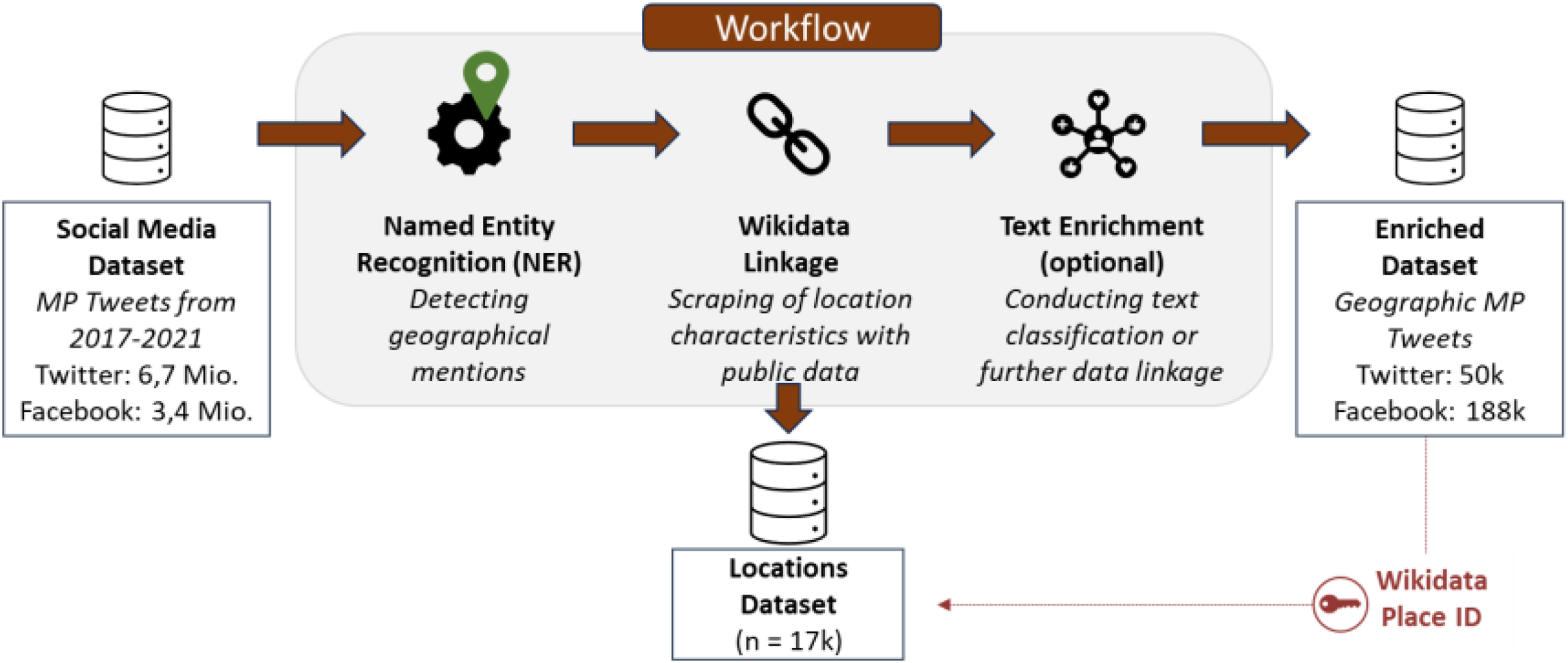
Named Entity Recognition: First, we applied named entity recognition (NER) to detect geographical mentions in the initial corpus of Twitter and Facebook data. We rely on the transformer-based model “German NER” (Akbik et al., 2018). The model was trained on the CoNLL-2003 German dataset (Sang and De Meulder, 2003), reaching state-of-the-art performance for the German language while also being publicly available on Huggingface. 2 We preprocess the social media posts by removing all URLs and mentions of accounts from the posts. Ultimately, we feed the data into the model and receive a list of locations for each post.
Wikidata Linkage: For each location identified through named entity recognition, we match and link the location to its corresponding entry in the Wikidata database (Wikimedia Foundation, 2024), a comprehensive knowledge base for Wikipedia with over 100 million records. Due to the non-deterministic nature of the matching process, where different locations may share the same name or be referred to by different names, we initially store the three most likely matches for each location in a list (see Appendix 1 for an example). We then gather relevant information for each identified location from the Wikidata database, such as geographic coordinates or the type of location, and store this data in a separate dataset containing 17,685 distinct locations. Following this setup, we query each identified location for each social media post to determine if the location lies within the electoral borders of the MP’s constituency. The rationale for this approach is that if multiple locations with the same name exist (e.g., there are 12 different locations named Hausen in Germany), the MP is likely referring to the location within their constituency. If the location is not located within the constituency, the most likely match determined by the query is finalized and linked as the corresponding Wikidata entry.
For our analysis, we define a place as a locally identifiable entity within Germany, understood as a settlement unit rather than as a single, formal administrative unit. We use settlement units in a substantive sense that refer to cities, towns, city districts, or villages that are commonly referenced in everyday political communication because they allow politicians to signal proximity to their constituency and reflect the everyday environments in which voters live. As a result, most identified places correspond to a German municipality or can be clearly assigned to one, as they represent well-defined local entities within municipal boundaries. Following this definition, we exclude posts referencing state, national, or international entities, as well as street-level locations or institutions that may cause ambiguous matches.
Measurement
Once all place references have been identified in MPs’ social media posts, we process the data in R using the sf package (Pebesma and Bivand, 2023). MPs with fewer than 10 identified places are excluded from the analysis. Moreover, as Berlin is the location that is most often mentioned by MPs, one needs to stress that it is also the host of parliament and can, therefore, be mentioned in way more contexts than, for example, a smaller location. For this reason, we have decided to remove Berlin as location from our analysis.
Before testing our hypotheses, we validate our workflow using different strategies, including comparison with human annotations. In addition, we replicate established findings of geographic representation showing that nominated (district) candidates are more likely to mention places within their constituencies than list candidates (Schürmann and Stier, 2023). To do so, we create a measure of constituency salience indicating whether each referenced place lies within an MP’s constituency (H0). 3 For list MPs, we define the constituency as the electoral district in which the MP stood as a candidate but did not win the constituency seat, ensuring comparability with directly elected MPs. For constituencies located in major cities, a place is also coded as an exact match if it falls within another constituency of the same city (see Appendix 3). We then compute the share of unique places within constituency borders for each MP.
To measure district distance (H1), we calculate the mean distance of all referenced places from the boundary of each MP’s constituency. All places located within the respective constituency are, for this hypothesis, assigned a distance of 0 km. This measure therefore captures how far MPs’ place references extend beyond their constituency, rather than proximity within the constituency itself. To measure service distance (H2), we first compute the distance in kilometers from each place centroid to the nearest general practitioner, pharmacy, elementary school, train station, post office, and supermarket. We then average these distances for each place. As we are focusing on the relationship between MPs and their constituencies in H2, we calculate the mean service distance across all referenced places within their constituency. Location of service facilities stem from Deutsche Bahn’s Open Data Portal and the “Points of Interest” dataset curated by the Federal Agency for Cartography and Geodesy (BKG).
Analysis
We use multivariate regression analysis to test our hypotheses. The main independent variable, mandate mode, is not randomly assigned: district and list MPs systematically differ in electoral success, communication focus, and other characteristics that may confound the relationship between mandate type and attention to local geography. We therefore refrain from making causal claims. Our goal is to derive correct descriptive inferences while adjusting for potential confounding factors.
To this end, we account for constituency-specific and individual characteristics. Because the distance from the constituency center is naturally constrained by district size, we include a control for constituency area to avoid bias stemming from geographical variation. District size also correlates with population density—cities contain more districts and, hence, via district elected MPs—which could otherwise attenuate the estimated relationship. In addition, we control for list position, incumbency, and demographic factors such as age and gender, as these may influence both mandate type and communication behavior. A list of all variables with descriptive statistics is displayed in Table 4.
Results
Measurement validation
We validate our computational workflow for detecting and linking places in political communication using different strategies. 4
Validation: Comparison with human annotations.

For NER, we hand-coded a subsample of 1000 randomly selected social media posts and calculated the recall (i.e., how many of the places identified using human coding were also detected by NER) and precision (i.e., how many of the places identified by the model were correctly identified), resulting in satisfactory metrics (precision = .86, recall = .88, F1 = .87). 5 For Wikidata linkage, we further hand-coded a selection of 500 places with their Wikidata ID. We again reached sufficient congruence (precision = .87, recall = .93, F1 = .90), giving us confidence that the places we identified were matched correctly with their corresponding Wikidata entry.
Second, we also inspect the distribution of places across our data. To do so, we carefully screened the most often mentioned 200 places that were matched in our final dataset (see Appendix 5). For each of these places, we screened the first 10 social media posts that contained the place. Except for one place, 6 the places were correctly matched.
Third, we inspect the predictive validity of our measure by replicating established findings of constituency salience, that is, politicians who are directly elected by their constituency being more likely to refer to places within their constituency than list candidates (Schürmann and Stier, 2023; Zittel et al., 2019). Figure 2 presents predicted values from a multivariate regression analysis, using the share of places located within a politician’s constituency as the dependent variable. Predicted values for mandate mode and district match.
The figure shows that in both datasets, directly elected candidates are more likely to mention places that are within the constituency of the MP compared to list candidates. On Twitter, the predicted probability is 0.58 for directly elected MPs versus 0.42 for list MPs, while on Facebook it is 0.40 versus 0.26.
Taken together, the validation steps in this chapter demonstrate that our computational approach to identifying and linking places yields a valid measure, which we can confidently employ in the subsequent analysis.
Descriptive statistics
Figure 3 and Table 4 in Appendix 7 present the descriptive statistics for both measures, district distance (DV H1) and service distance (DV H2), differentiated by mandate mode (IV).
Figure 3 shows clear differences between the two groups in the types of places they reference. The top row (H1) illustrates log-transformed district distance: Directly elected MPs predominantly mention locations within or near their constituency, whereas list candidates are more likely to refer to distant places. The bottom row (H2) depicts log-transformed service distance: Directly elected MPs talk more about places with lower levels of service accessibility, while list candidates tend to focus on well-served localities. This pattern is pronounced in the Facebook dataset but less evident in the Twitter data. Furthermore, compared to all German municipalities, MPs tend to mention places with higher population density and better service accessibility. While this selection effect is more pronounced on Twitter, both subsamples still maintain considerable structural variance (see Figure 7). Distribution of distance measures. All distance measures are log-transformed.
Hypotheses
Figure 4 displays the scaled regression coefficients for both outcomes: district distance (H1, left panel) and service distance (H2, right panel). Scaled regression coefficients.
For H1, we observe that directly elected MPs are more likely to mention places closer to their constituency compared to party list candidates, supporting our expectations. Yet, the confidence intervals lie close to zero, particularly in the Twitter dataset, where they are comparatively wide (p = .04). For H2, the effect of mandate mode also aligns with our expectations: Directly elected MPs are more likely to mention deprived places inside their constituencies, that is, places that lack access to public services. However, the size of the estimates differs between the two datasets, with strong and significant effects in the Facebook data. However, our Twitter data do not show statistically significant effects, likely due to the limited number of referenced places in the dataset, although the direction of the estimates suggests that a larger number of cases might yield to similar results. Overall, the results provide support for our hypotheses.
In the Appendix in Figure 8, we present additional robustness checks for our service deprivation measure. First, we examine different ways of calculating the service deprivation index. Including all types of services (e.g., supermarkets) may introduce measurement bias due to low spatial variability and inflate correlations within the index. We therefore consider two alternative specifications: maximum variance, based on hospitals, train stations, and secondary schools, which captures greater spatial variation in service availability; and minimum correlation, based on hospitals, train stations, and elementary schools, which reduces inter-service correlations while incorporating more evenly distributed services. Second, we test alternative operationalizations that account for all places, not only those mentioned within MPs’ constituencies, to account for potential surrogate representation beyond the directly referenced locations. Across all specifications, the results remain consistent, reinforcing the robustness of our main findings.
Discussion and conclusion
Our analysis aimed to shed light on the institutional motivation for geographical representation in an MMP. We employ a novel workflow designed to detect places in political communication and applied it to a social media dataset of elected MPs. Our results show that the mandate mode has a significant and strong impact on geographic representation on social media. Our analysis extends previous research by matching, linking, and geolocating places using the Wikidata database. We showcase the advantage of our method by deriving the distance of places from constituency and deprivation in terms of access to everyday necessities. As expected, directly elected MPs are more likely to mention places located closer to their constituency and places with more limited access to essential services within their constituencies. Although the effects do not reach conventional levels of statistical significance in the Twitter data, the direction of the estimates aligns with these expectations. This suggests that they follow, compared to list candidates, two modes of geographic representation: first, attending to locations within or close to their constituency to win the votes of their constituents; and second, signaling attentiveness and symbolic inclusion of underserved areas.
Our method will allow for a more thorough and detailed understanding of geographic representation. By linking places to a variety of characteristics, including economic, social, and other indicators, we can improve insights into the mechanisms driving geographic representation. Future research might explore the factors that affect how politicians perceive and communicate certain places. Is “Washington” or “Berlin” just a meeting place, a constituency, or a symbolic “swamp” of corruption? Can we detect stereotypical depictions of places that serve political agendas (Haffert, 2021)? Do politicians’ statements about geographic entities align with the actual characteristics of these locales, whether they are depicted as “crime hotspots” or “left-behind places”? Unpacking these mechanisms of geographic representation could enhance our understanding beyond the mere mentioning of places in political discourse.
However, our analysis also comes with limitations. On the one hand, our definition of places is limited to municipalities, cities, city districts, or villages and does not include broader geographic references or street-level entities, such as neighborhoods, culturally or territorially defined regions, and cultural landmarks and institutions. We also refrain from including state-level (Länder) references that may be particularly relevant for list MPs. Moreover, our deprivation measure is necessarily conditional on places that enter MPs’ communication: places that are not mentioned cannot be observed, implying that our estimates capture deprivation among mentioned places only and thus represent a conservative (lower-bound) assessment of attention to underserved areas. Nevertheless, our method generally supports detailed handling and filtering of places based on their properties ∗∗ in the Wikidata database. For example, researchers can adapt the query in the matching process to also include “metropolitan regions” or “cultural landmarks.” This will be particularly useful for researchers with domain knowledge who are interested in specific regions or policy contexts and wish to incorporate various forms of place into their analysis.
While we recognize that signaling behavior on social media plays a crucial role for geographic representation (Zittel et al., 2019), we still lack sufficient knowledge on the overall impact of constituency salience on voters’ perception of politicians and their electoral reward. Therefore, additional research is necessary to investigate the consequences of signaling on the demand side of the politician–voter relationship, specifically how voters perceive and evaluate geographic representation from their elected officials.
Supplemental material
Supplemental Material - Between home turf and hinterland: Directly elected MPs focus more on local and deprived places than list candidates on social media
Supplemental Material for Between home turf and hinterland: Directly elected MPs focus more on local and deprived places than list candidates on social media by Lukas Birkenmaier, Anne-Kathrin Stroppe, L. Constantin Wurthmann, and Marius Sältzer in Research & Politics
Footnotes
Funding
The scientific work of Anne-Kathrin Stroppe is funded by the German Federal Ministry of Research, Technology, and Space (BMFTR) and the EU Next Generation Fond. The remaining authors received no financial support for the research, authorship, and/or publication of this article.
Declaration of conflicting interests
The authors declared no potential conflicts of interest with respect to the research, authorship, and/or publication of this article.
Carnegie corporation of New York Grant
This publication was made possible (in part) by a grant from the Carnegie Corporation of New York. The statements made and views expressed are solely the responsibility of the author.
Supplemental material
Notes
References
Supplementary Material
Please find the following supplemental material available below.
For Open Access articles published under a Creative Commons License, all supplemental material carries the same license as the article it is associated with.
For non-Open Access articles published, all supplemental material carries a non-exclusive license, and permission requests for re-use of supplemental material or any part of supplemental material shall be sent directly to the copyright owner as specified in the copyright notice associated with the article.