
Abstract
Tropical river deltas, and the social-ecological systems they sustain, are changing rapidly due to anthropogenic activity and climatic change. Baseline data to inform sustainable management options for resilient deltas is urgently needed and palaeolimnology (reconstructing past conditions from lake or wetland deposits) can provide crucial long-term perspectives needed to identify drivers and rates of change. We review how palaeolimnology can be a valuable tool for resource managers using three current issues facing tropical delta regions: hydrology and sediment supply, salinisation and nutrient pollution. The unique ability of palaeolimnological methods to untangle multiple stressors is also discussed. We demonstrate how palaeolimnology has been used to understand each of these issues, in other aquatic environments, to be incorporated into policy. Palaeolimnology is a key tool to understanding how anthropogenic influences interact with other environmental stressors, providing policymakers and resource managers with a ‘big picture’ view and possible holistic solutions that can be implemented.
Introduction
Tropical river deltas are dynamic and productive ecosystems that sustain livelihoods and have been important in the development of civilisation. Deltas form through the deposition of sediment and nutrient inputs from both the upstream catchment by freshwater flow and from the nearshore environment by the tide, creating fan-like landscapes intersected by a distributary channel network (Hiatt and Passalacqua, 2015; Tockner et al., 1999). Deltas are often referred to as socio-ecological systems (SESs) (Berkes and Folke, 1998; Colding and Barthel, 2019; Kuenzer and Renaud, 2012) because of the interconnected relationships between human populations and the ecosystem services provided by numerous habitats from upstream catchments to the coast. Even though tropical deltas are important centres of natural resource extraction, agriculture, aquaculture and industry (Adams et al., 2018; Adekola and Mitchell, 2011; Kuenzer and Renaud, 2012), they are facing mounting pressures from anthropogenic activities and environmental change that jeopardise human populations and the vital ecosystem services they provide (Islam et al., 2015; Kuenzer and Renaud, 2012).
Anthropogenic influence in any part of the watershed can lead to issues downstream and throughout the delta. For example, the construction of dams along the Mekong River basin has reduced freshwater flow to downstream Vietnam, resulting in increased saline intrusion within coastal waterways and soils (Li et al., 2017; Eslami et al., 2019). Sand mining, in addition to dam construction, reduces sediment flux downstream and increases riverbank and coastal erosion (Hackney et al., 2020; Jia et al., 2007; Marchesiello et al., 2019). Widespread nutrient enrichment arising from agricultural intensification (e.g. fertiliser runoff) and heavy metal pollution by industrial or urban discharges into surrounding waterways has led to water quality degradation (Downing et al., 1999; Ezekwe and Edoghotu, 2015; Rahman et al., 2011). Environmental degradation due to anthropogenic influences negatively
To address these interacting challenges, governments often try to balance economic development and environmental protection by instituting management policies for the sustainable use of delta resources. However, a lack of long-term monitoring (over decades to centuries – most regular monitoring does not precede the 1990s) (Davidson et al., 2013; Smol, 1992) means it is difficult to detect changes in delta biogeochemistry, ecological regimes, or driving stressors, hampering appropriate policy responses. In the absence of lengthy water quality, sediment transport and hydrological data, palaeolimnology – the study of past lake and wetland sediments to reconstruct historical limnological and climatic conditions – can provide long-term perspectives of natural baselines (i.e. prior to a disturbance) and variability within ecosystems, as well as the impacts humans are having on the environment including the effectiveness of existing policy or management regimes.
Palaeolimnology uses chronologically controlled (e.g. radioisotope dating – 210Pb, 137Ams, 14C) sediment cores to provide temporal context in the study of organic and inorganic remnants found in sediments (referred to as proxies) to uncover the historical environmental conditions of aquatic systems and their catchments over timescales of decades to millennia (Figure 1). Palaeolimnological proxies have been used successfully to detect shifts in the biological, environmental and physical conditions within some tropical aquatic ecosystems (Velez et al., 2018; Wengrat et al., 2018; Zong et al., 2010a). Such shifts can be attributed to specific events or activities (e.g. dam construction, climate change, land-use change (Bianchi et al., 2013; Inda et al., 2016; Zeng et al., 2018)) and provide a valuable resource for setting restoration goals and management strategies (Alexson et al., 2018; Köster et al., 2007; Perga et al., 2015). The power of proxies to detect long-term environmental and ecological change, and to elucidate the complex dynamics existing between humans and deltaic environments, have led to palaeolimnological methods being used to inform tropical delta management plans (Escobar et al., 2020). Palaeolimnology can also demonstrate the timescales over which changes within a system occur; from long-term shifts in hydrology to short-term pollution impacts, as well as understanding contemporary or predicted conditions (e.g. land-use change, climate change) in various aquatic systems within the context of historical baselines (Bennion et al., 2011). Here, we argue that policymakers and resource managers in tropical nations should engage with the use of palaeolimnology more frequently to better understand the changes mega-deltas are undergoing and work for greater sustainability within these systems.
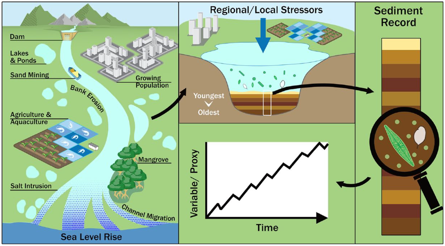
Stressors on river delta systems may be better understood using palaeolimnology. This diagram illustrates various stressors that may have significant impacts on delta systems, but sediments accumulating in aquatic sediments may hold clues as to how the system is responding over time, and if the systems are responding to management plans aimed at mitigating anthropogenic impacts.
In this review, we aim to highlight how palaeolimnology can be used to inform management options for three key issues faced by tropical delta systems: (1) hydrology and sediment supply, (2) salinisation of freshwaters and soils and (3) nutrient enrichment and pollution of waterways. We discuss how palaeolimnology has already contributed to our understanding of these issues across different geographical regions, and how it has contributed to resource management in other environmental settings, and explaining how its inclusion can serve to strengthen future management plans in tropical delta systems. We argue for palaeolimnology to be integrated as a key management tool for governments, policymakers and resource managers, alongside robust routine monitoring.
Hydrology and sediment supply
Central to the functioning of delta environments is hydrology (Dada et al., 2018; Le et al., 2007) and sediment flux (Coleman and Wright, 1975; Rahman et al., 2018), which sustain aquatic ecosystems and processes of land accretion or erosion. Human modifications such as dam construction (Mikhailov et al., 2015; Xue et al., 2011), channel alterations (Restrepo and Kettner, 2012; Zhang et al., 2009) and land-use change (Remondi et al., 2016; Setti et al., 2020) can drastically transform flooding frequency and occurrence. These modifications can reduce freshwater supply to deltas, allow tidal flow of seawater further inland (Eslami et al., 2019; Gole and Vaidyaraman, 1967) and affect sediment flow, to cause excessive accretion or erosion in different regions of a delta. Excessive riverbed siltation can increase water levels that risk overtopping artificial embankments surrounding low-lying, reclaimed land to keep out river water and causes prolonged flooding (Auerbach et al., 2015), or lead to a net export of sediment to the open sea, resulting in land erosion and channel widening (Auerbach et al., 2015; Guchhait et al., 2016; Liu et al., 2018). Ecosystems in lower delta regions, such as mangrove forests, can be adversely affected by reduced sediment flux. When accretion rates within the forest are reduced, forests can drown if accretion rates fail to keep pace with sea level rise (Friess et al., 2019; Nienhuis et al., 2020). Sand mining, common in the Mekong River, also reduces sediment flux and exacerbates bank erosion (Hackney et al., 2020; Jia et al., 2007).
To diagnose the causes and consequences of human-induced changes to hydro-sediment dynamics (see Boxes 1 and 2), palaeolimnological research can detect shifts in water flow or flooding frequency by tracking ecological changes to phytoplankton communities or shifting nutrient regimes (Chen et al., 2018; Liu et al., 2012). For example, a study on the long-term trends in the hydrological regime of a shallow lake in the Magdalena River in Colombia based on phytoplankton and biogeochemical markers indicated that the existing lake shifted first from a flood-dominated riverine system to a connected wetland system, then shifted again to a lake system ~60 years ago (Lopera-Congote et al., 2021). This reduced hydrological connectivity, partly caused by land-use change around the lake, contributed to increased sediment run-off and eutrophication (Lopera-Congote et al., 2021). This study highlighted that the best management option was to increase connectivity with surrounding hydrology.
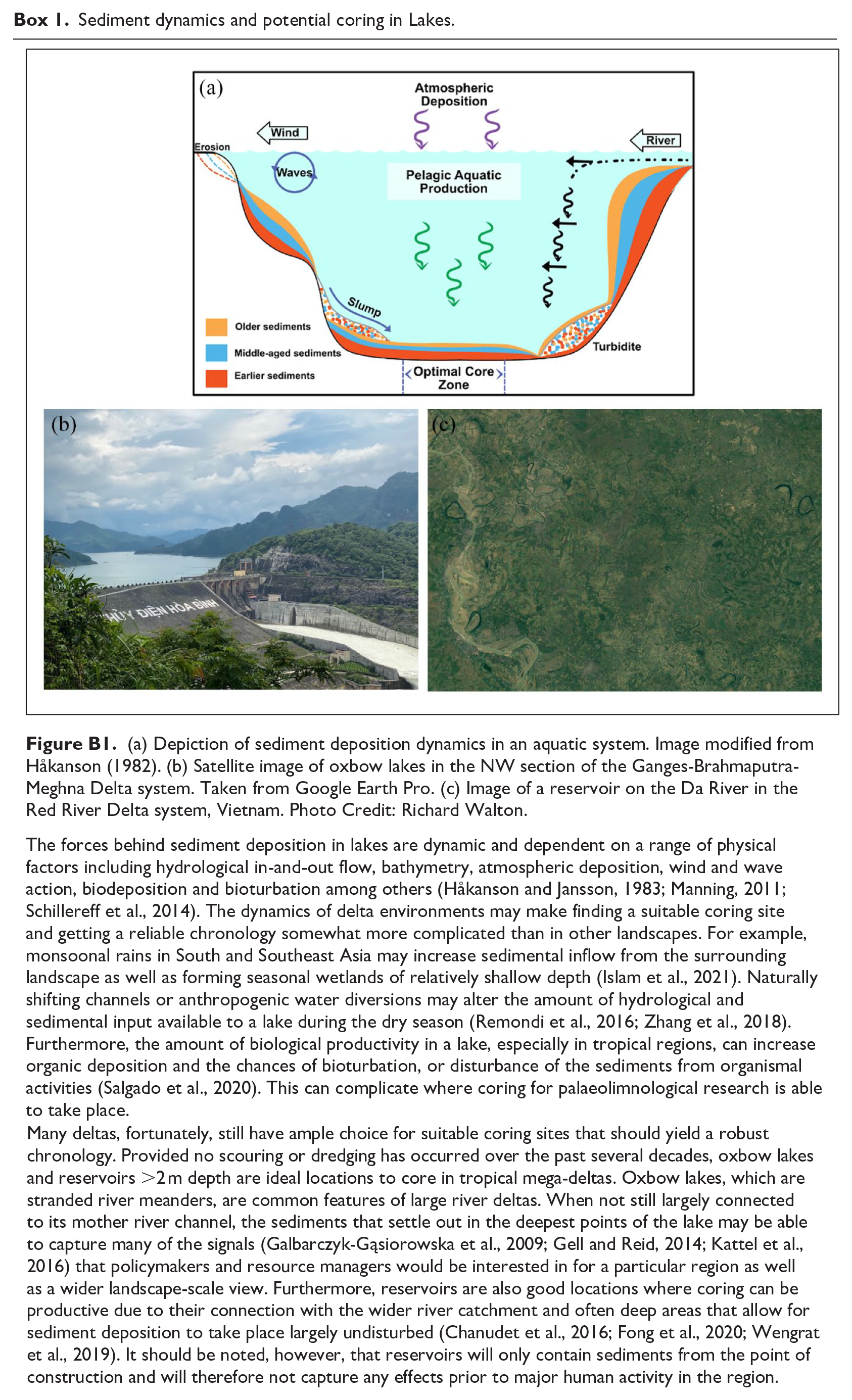
Sediment dynamics and potential coring in Lakes.
The Yangtze River floodplain.

Palaeolimnology is particularly useful in understanding changes in hydrology and sediment flux. Shifts in sediment accumulation rates within a particular basin can be quantified by radiometric dating (Cohen, 2003; Foucher et al., 2021), and shifts in hydrological sources and connectivity of deltaic lakes can be understood through a range of techniques including grain-size analysis and geochemical or organic tracing of sediment sources (Collins et al., 2020). Both aid in understanding elemental point sources and how that has influenced ecological conditions (Bertrand et al., 2005; Liu et al., 2012; Salgado et al., 2020). While difficulties may exist in finding suitable coring sites (see Box 1), careful employment of palaeolimnology in tropical deltas should be able to better help managers understand how changing hydrology or sediment fluxes can impact their resources.
Salinisation
Excessive saline intrusion into coastal water bodies is a growing problem in South and Southeast Asian delta communities (Clarke et al., 2018; Eslami et al., 2019; Szabo et al., 2016a). Increased instances of salinisation of soils and waterways are threatening livelihoods by reducing agricultural and aquacultural crop harvests, making coastal aquifers unusable and altering ecological functioning (Habiba et al., 2014; Hossain et al., 2016; Tran et al., 2022). Salinisation can be a gradual and irreversible process (caused by sea-level rise, salinisation of groundwater, or an excess of nutrients in floodplain agricultural fields) or can occur in temporary, periodic pulses (storm surges or seasonal droughts). The history of natural salinisation and the triggers for its occurrence and impacts in comparison with anthropogenically-driven salinisation need investigating as a key tool in managing this problem in these regions.
Fortunately, palaeolimnology and proxy indicators of salinity have been frequently employed (Table 1) and used to change policy on managing salinisation in coastal environments (Gell et al., 2007; Salgado et al., 2020). Reconstructing the history of change across multiple ecosystem components provides a much more robust understanding of salinity changes within the wider terrestrial-aquatic system (Gell et al., 2002; Reid et al., 2002; Smol and Stoermer, 2010). Palaeolimnological studies provide management insights into the vulnerability of lake and wetland systems to salinisation by examining the historical development of delta systems. For example, palaeolimnological studies have shown that Tonle Sap Lake originated as a brackish waterbody tied to the Mekong (Penny, 2006) and has tracked the response of mangrove coverage in Cambodia to shifts in salinity (Li et al., 2012) prior to the Mekong Delta progradation into modern-day Vietnam. Other studies have shown reductions in freshwater discharge are responsible for rising salinity in Brazilian and East Asian deltaic waterways (Castro et al., 2013; Cho et al., 2017; Zong et al., 2010b). Several studies have also linked shifts in salinity to specific, sudden events such as a storm surge event impacting deltaic lakes in the Arctic Circle (Deasley et al., 2012; Pisaric et al., 2011; Thienpont et al., 2015) leading to long-term ecological impacts, a scenario in which resource managers in tropical mega-delta systems may want to prepare for as such extreme events are argued to become more likely (Bevacqua et al., 2020; MacLeod et al., 2021; Rao et al., 2020).
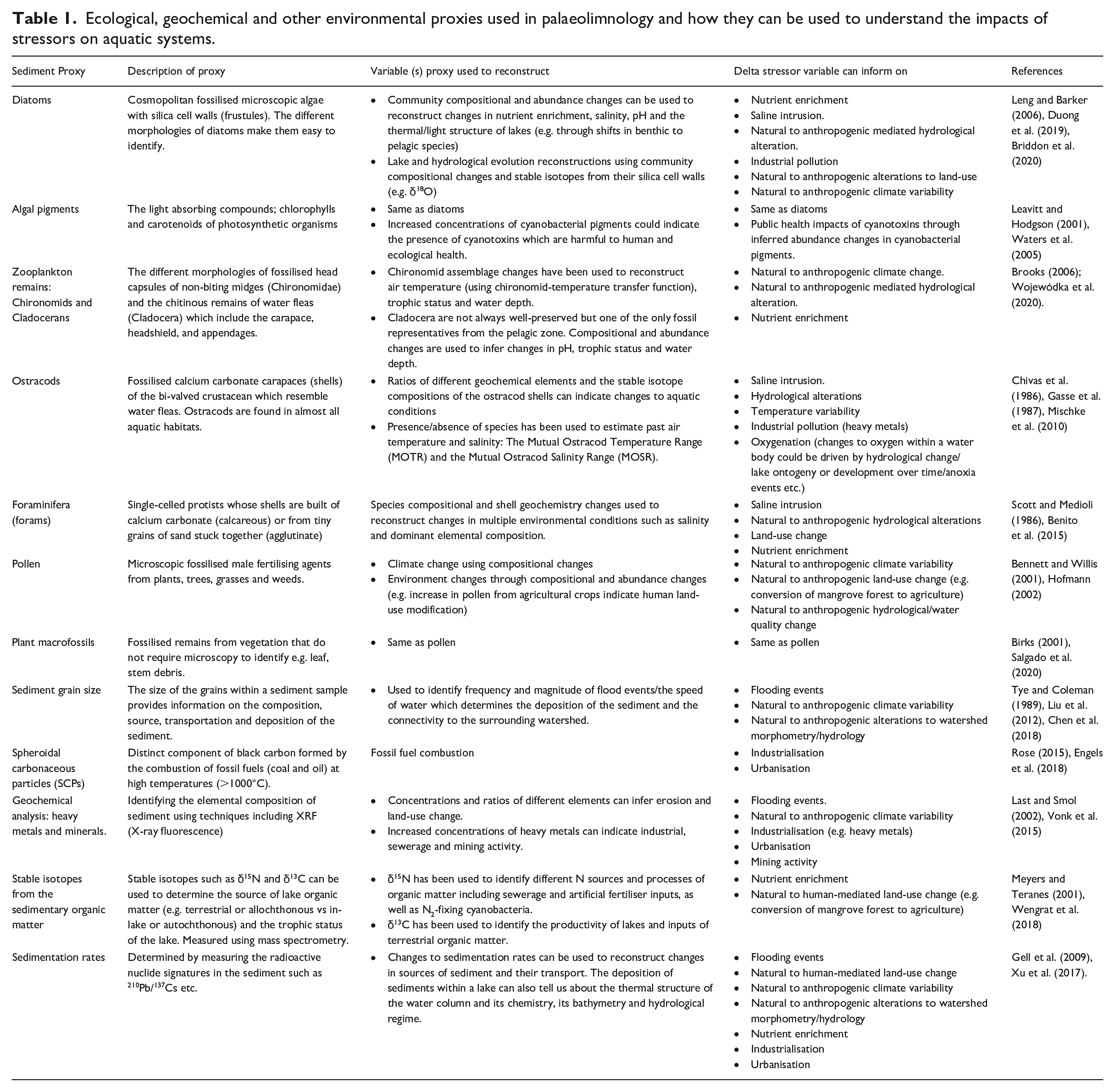
Ecological, geochemical and other environmental proxies used in palaeolimnology and how they can be used to understand the impacts of stressors on aquatic systems.
Palaeolimnology can help elucidate the impacts of recent and sudden events of salinisation in ecological systems, as well as putting these types of events into historical and climatic context. For example, Roberts et al. (2022) found that coastal lakes in eastern Norfolk, England, had been regularly inundated with seawater during past storm surge events. Recovery to pre-event conditions was dependent not only on the severity of the event, but also on how the intrusion event interacted with other drivers of ecological conditions such as sedimentation rates or ongoing modifications to the catchment, that is, agricultural drainage (Roberts et al., 2022). When combining modern sampling and monitoring techniques (see Pisaric et al., 2011; Thienpont et al., 2012) with local community knowledge (Kokelj et al., 2012), use of palaeolimnology to better track and understand the scale of salinity impacts in tropical deltas can offer a more holistic solution for resource managers and policymakers.
Nutrient enrichment and other anthropogenic pollutants
Nutrient and pollutant levels play key roles in determining water quality within delta systems. Over the last ~70 years, anthropogenic impacts on biogeochemical cycling in aquatic systems (Rockström et al., 2009) have led to limits being set to avert widespread eutrophication of global marine and freshwater systems (Steffen et al., 2015). Eutrophication, from high nitrogen (N) and phosphorus (P) inputs, results in excessive primary production and can trigger shifts in aquatic community assemblages such as the onset of harmful algal blooms (Scheffer, 1989). Elevated levels of eutrophication may lead to reductions in aquatic biodiversity (Jeppesen et al., 2000; Sayer et al., 2010), which can surpass key ecological thresholds such as a clear water, macrophyte-dominated system becoming a turbid phytoplankton dominated system (Davidson and Jeppesen, 2013; Davidson et al., 2023; Jinglu et al., 2007). Freshwater and marine environments can respond differently to nutrient loading. Freshwater environments are typically P-limited (although see Lewis, 2000 for tropical exceptions) whilst marine environments are N-limited (Cloern, 2001; Pinto-coelho, 1998). Increasing reactive nitrogen pollution in tropical deltas (Lee et al., 2019) has led to an exacerbation in the total number of coastal eutrophication cases.
Nutrient sources arising from anthropogenic activities can be readily detected in tropical river systems, such as in the Red River Delta, Vietnam, where four nutrient point sources were detected using stable isotopes (Luu et al., 2020) and may be preserved in the sediment record as Fontana et al. (2014) revealed in their study that untreated sewage was the cause of eutrophication in a Brazilian reservoir. Moreover, stronger aquatic biogeochemical responses to eutrophication have been documented in tropical delta systems when compared with temperate regions (Corredor et al., 1999; Downing et al., 1999). As well as (now scarce) unmodified natural lake systems, reservoirs have proven useful in reconstructing nutrient enrichment over more recent timescales due to their importance as reliable public water resources and known period of creation (Lewis, 2000). Studies in three tropical reservoirs in Brazil have shown that prolonged eutrophication over several decades has altered and simplified the phytoplankton community, with cascading impacts on other species (Costa-Böddeker et al., 2012; Wengrat et al., 2018) and with increased occurrences of toxic cyanobacterial blooms (Fontana et al., 2014).
A common impact of eutrophication is the shift in planktonic communities to frequent and intense cyanobacteria blooms (Labaut et al., 2020; O’Neil et al., 2012; Taranu et al., 2015). These blooms can lead to losses in aquatic biodiversity, reduced attenuation of light in the water column for photosynthetic organisms, and bottom water hypoxia triggering fish kills and lakebed internal loading. As a result, lakes can become locked into turbid states (Merel et al., 2013; Visser et al., 2016). Blooms also have the capacity to produce harmful algal toxins (e.g. hepatoxins and neurotoxins) causing Harmful Algal Blooms (HABs) in high concentrations. Algal pigment biomarkers or photosynthetic sulphur bacteria (for identifying lake anoxia) in sediments (Table 1) can identify the relative proportion of algal groups over time (e.g. eukaryotic algae (diatoms, chlorophytes, cryptophytes), cyanobacteria and photosynthetic bacteria) and their response to anthropogenic climate change and pollution. The consequences of increased phytoplankton productivity in response to eutrophication can favour cyanobacteria and mixotrophic algal groups due to resource competition and light availability (Gangi et al., 2020).
Reconstructing historical eutrophication and its associated effects on the timing and rate of ecosystem deterioration is valuable for informing tangible management plans. For instance, palaeolimnological methods can be used to determine the nutrient sequestration rates by coring reservoirs upstream of deltas and verify estimates of nutrient starvation caused by damming (Quynh et al., 2005). Alternatively, Wengrat et al. (2019) were able to separate natural trophic variability within five Brazilian reservoirs and showed that eutrophication of each reservoir was a gradual process with varying levels of ecological impact. In this instance, the authors were able to advise managers that not all trophic changes in the reservoirs were a response to anthropogenic impacts, and the first several years of a reservoir’s existence are too unstable to be used as reference conditions, with the most effective management of the reservoirs would come from a catchment-scale approach (Wengrat et al., 2019).
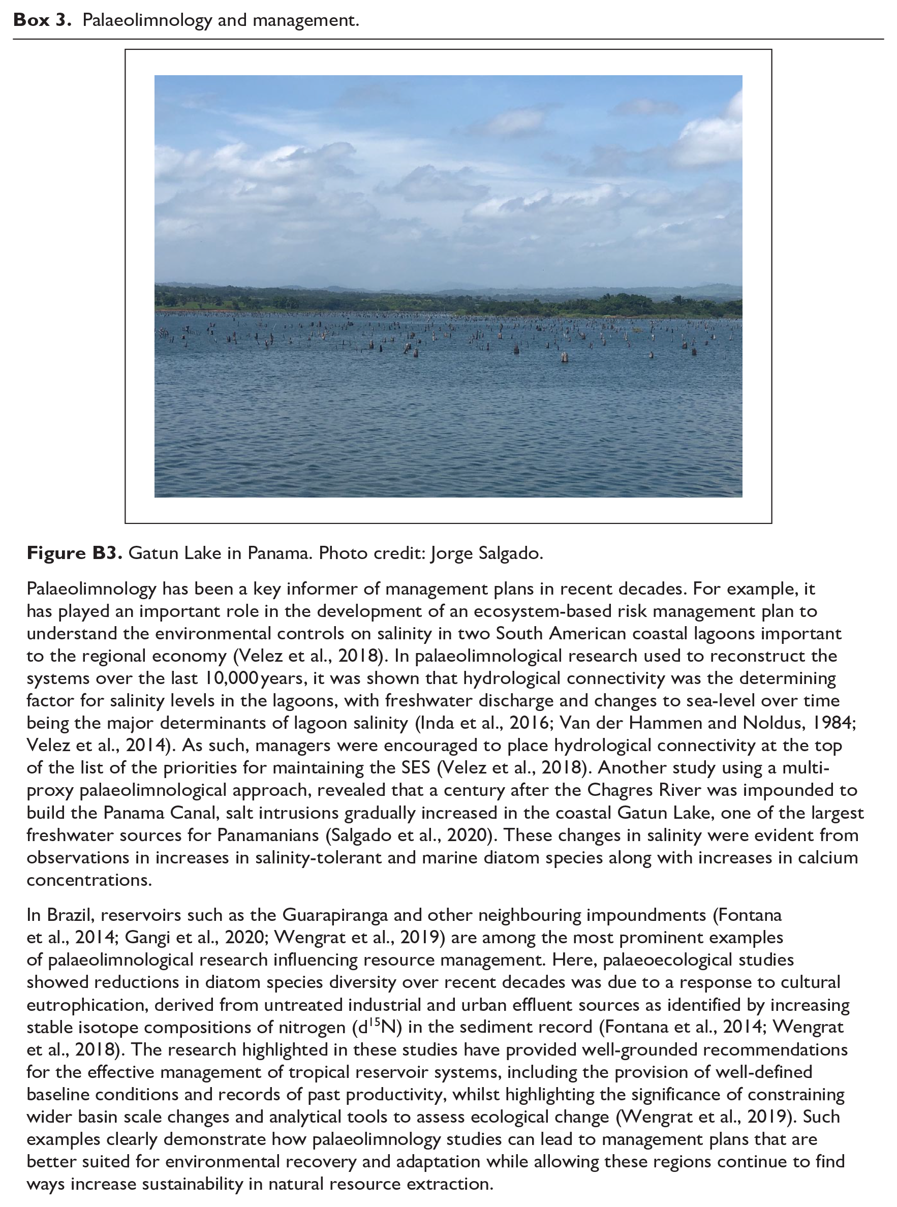
As well as nutrient enrichment, the rise of the Anthropocene has also seen the increasing transmission of organic and inorganic pollutants (ranging from metals, pesticides, fungicides, persistent organic pollutants (POPs), personal care products (PCPs), polycyclic aromatic hydrocarbons (PAHs) and other chemical compounds into aquatic ecosystems. Pollution events and their subsequent effects can often be clearly detected in the sediment record. For example, Costa-Böddeker et al. (2018) found elevated levels of Pb, Cr and Ni amongst other metal pollutants accumulating in the last two decades in the Thi Vai Estuary, Vietnam due to recent industrialisation and changes in land use. In Central America, Salgado et al. (2020) also found that the construction of the Panama Canal led to increasing pollutant delivery in Gatun Lake typically associated with increased mining and fossil fuel combustion such as zinc (Zn), copper (Cu) and lead (Pb). Coupling the timing of pollutants entering the system with collapse ecological communities through palaeolimnology can provide the necessary evidence needed to introduce regulation into the system (Sayer et al., 2006).
Mangrove forests are also indicator environments of pollutants in tropical deltas because they sequester material transported from both land and sea. Pollutant trapping is a recognised ecosystem service potentially acting as an important policy driver for the restoration and protection of these valuable forests. By reducing pollutant concentrations in the water column, wider ecosystem health is improved (Vo et al., 2012). Palaeolimnological methods employed on more recent sediments may help assess changes in the severity of pollution over time and determine whether measures to reduce pollution release are working. For example, treaties on halting atmospheric testing of thermonuclear weapons have resulted in a sharp decrease of anthropogenic radionuclide pollution since the 1970s (Walling et al., 1995), although continued testing in some areas of the tropical Pacific may provide distinct pollution signatures (Chaboche et al., 2022) during the 1970s phase out. Use of palaeolimnology in mangrove ecosystems has been used to track heavy metal and hydrocarbon contaminants from boats, cars and effluent (Costa et al., 2015), as well as coastal eutrophication (reconstructed by diatom species assemblage and C:N ratio change (Logan and Taffs, 2009; Macreadie et al., 2012)), and microplastic pollution (Deng et al., 2021). These methods can then be used to identify the main sources for the pollution (such as urbanised areas, sewage outflows, tourism activities and ocean circulation), and recommend on steps needed to control pollution levels and provide remediation (Wu et al., 2014). The extent of transboundary impacts relative to those arising from local pollution sources, however, remains unknown for many tropical river systems, making palaeolimnology a key tool to answer such questions.
Multiple stressors
The key issues discussed above are often considered in isolation by policymakers and resource managers. Aquatic ecology and fluvial dynamics are, however, complex systems driven by multiple stressors, resulting in a wide array of challenges to tropical delta resilience (Renaud et al., 2013; Szabo et al., 2016b; Woodroffe et al., 2006). As we show here, palaeolimnology can help resource managers understand the impact of multiple stressors at landscape-scales, in a more holistic way. Crucially, it can interpret sediment records from both terrestrial and aquatic stressors within the delta catchment (Gell et al., 2009; Hunt and Rushworth, 2005; Wengrat et al., 2019) to disentangle multiple impacts (Anderson et al., 2006; Smol, 2010) and assist resource managers and policy makers in implementing the best solutions (see Box 3), particularly when multiple basins are compared across regions to find primary stressors (Mills et al., 2017).
Palaeolimnology and management.
Many different anthropogenic activities are influencing deltaic changes in hydrology, sediment supply, soil and water salinity and nutrient/heavy metal pollution, such that managing a single stressor is unlikely to resolve the matter (Jackson et al., 2016; Vinebrooke et al., 2004). Palaeolimnological studies have helped understand how multiple stressors can be synergistic or antagonistic over time to create the physical and ecological issues we observe in the present. For example, Salgado et al. (2019) studied the effects of historical changes of native aquatic plants to lake surface area, eutrophication and the invasion of water hyacinth (Eichhornia crassippes) in Lake Fúquene, Colombia. By using multiple cores and a multi-proxy approach (plant macrofossils, pollen and trace elements) the study found that the increase in invasive hyacinth was triggered by lake management practices (diversion of hydrological inflow) acting synergistically with internal and continued external nutrient loading leading to eutrophication, benefitting the spread of water hyacinth over native species.
Elsewhere, a study in Lake Furnas on São Miguel Island, Azores, Portugal identified that eutrophication, warming water column temperatures and anthropogenically introduced fish species in the 19th century, could not explain present-day anoxia in the system. Only the co-occurrence of the three stressors, in addition to the introduction of larger piscivorous fish in the late-20th century, could explain phytoplankton community changes that depleted the already-reduced levels of dissolved oxygen creating anoxic conditions (Buchaca et al., 2011). Both above examples pre-dated monitoring of those systems meaning that palaeolimnology could fill in the data gaps and help to better explain multiple stressors on deltaic systems (Salgado et al., 2020; Smol, 2010; Wengrat et al., 2019).
Conclusion
The stresses on tropical river deltas and their communities, both naturally occurring and anthropogenically induced, constitute a major threat to tropical river delta SESs. Many processes such as changes to hydrology and sediment supply, ingress of saline waters and excessive inputs of nutrients and pollutants occur at timescales that are either too extended or precede the onset of monitoring. Environmental data availability is limited in many delta regions, which endangers the ability for delta ecosystems and human communities to proceed in a resilient and sustainable manner. Palaeolimnological methods can address the problems of data scarcity in delta regions, enabling managers to set reference conditions for remediation and to better understand the long-term dynamics driving the scale of impact from individual and multiple stressors. Commissioning the use of palaeolimnology in the updating of policy or management plans can provide the critical long-term data on sensitivity and change that is key to making such action well-informed and effective. We therefore strongly encourage governments, resource managers and scientific experts alike to more fully use palaeolimnological tools and advocate for their inclusion at the outset of any remediation efforts in these regions.
Footnotes
Declaration of conflicting interests
The author(s) declared no potential conflicts of interest with respect to the research, authorship, and/or publication of this article.