
Abstract
Recent geographical scholarship has mainly focussed on the disjunctures between linear and cyclical time in urban development. This paper proposes a notion of distant time as a metaphor of temporal power that keeps marginal citizens at a governable distance from the state. Taking the case of Shimla, an erstwhile Summer Capital of colonial India and a popular tourist town in the Himalayas, it argues that distant time emerges from the temporal reordering of ‘native’ settlement on a fragile ecological landscape ravaged by the colonial state, that is then repeated in postcolonial imaginaries of smart urban futures. Reading ‘along the grain’ of colonial archives of incremental housebuilding by the ‘natives’, as well as interviews with current working class residents of Shimla living under threat of demolition from proposed smart city projects, this paper suggests that distant time is also a space for marginal citizens to claim temporal justice. Even as the state engages in temporal distancing through post/colonial planning, marginal citizens use waiting, confusing, and circumventing as tools of temporal arbitrage. They highlight that aspirations for smart urban futures are not just produced in the ‘here and now’ of the present, but also from the ‘there and then’ of different pasts and futures.
Keywords
Introduction
In the summer of 2023, a cloudburst led to devastating flash floods and landslides in the Indian Himalayas. In the regional state of Himachal Pradesh, incessant rain and thunderstorms literally dislodged the hillsides of towns and villages, leading to destruction of houses, buildings, roads and cutting off connectivity (both physical and digital) with the plains. Hundreds of people lost their lives and livelihoods as death tolls reached over 250 1 with about 2000 people moved to relief camps 2 in the state. Environmentalists reinforced warnings of climate change whilst also cautioning against the continuous construction activity over the last few decades that had sought to widen national highways and increased urbanisation in the Himalayan region. The devastation was faced significantly in Shimla – the Himachal State capital – where an entire hillside including a low-income neighbourhood of Krishna Nagar came sliding down.
Shimla, a city of about 200,000 people, is a popular tourist destination in the Indian Himalayas, which in 2017 was declared as a future smart city under the national 100 smart cities initiative (Ministry of Urban Development, GoI, 2017). As former summer capital (1864–1945) of the British Colonial Empire, Shimla has a long history of urbanisation. Colonial Shimla was built on the top of the hill, above the historic Cart Road, by propelling soil and building materials down the hill below Cart Road where ‘native subjects’ settled to service the Empire. This area is now called Krishna Nagar, a settlement literally built on the debris of Empire, which for a century at least, has been continuously sliding downhill. Each year, as the monsoons arrive and rivulets overflow, Shimla's tourist town at the top of the hill sheds more water, waste, and debris down the slopes into the houses and streets of the working class settlements in Krishna Nagar below. As Shimla was declared a smart city in 2017, its proposal for a radical demolition and redevelopment of its working class neighbourhoods down the same slopes as part of this smart city initiative has further increased concern for a fragile hill ecology in the future.
I start with these events to draw attention to the seeds of urban futures that are sown in the 'there and then' – in the distant time of Shimla's colonial urbanisation. Distance has been a universal metric of capitalist growth as well as an Imperial system of asserting power, but distance here is the separation between a smart city's perceived technological dominance, longue durée of hillside urbanisation, cyclical time of ecological ‘slow emergencies’ (Anderson et al., 2020) and delayed justice for marginal citizens settled along the hill. Shimla's future is imagined through the straight lines of vertical distance and connectivity that maintain the hierarchies of social order between the top and bottom of the hill, which are kept worlds apart, by distancing the ‘other’ in a ‘frozen time’ – the time of pre-modernity, and therefore an experience of precarity, uncertainty, and continuous anticipation of disaster.
In this paper, I use the concept of ‘distant time’ to reflect the temporality that stretches between the top and bottom of the hill, tourist city and working class settlement, municipal governance and marginal urban lives, colonial planning convictions and smart urban futures. I argue that distant time is a form of statecraft that uses a combination of time and distance (materially and socially) to produce a form of marginality across past, present, and future. Distant time works as a ‘device for temporal distancing’ (Fabian, 2014: 30) between the ‘future present’ (Adam, 2018) of smart Shimla and its ‘past future’ as summer capital of the British colonial empire. Distant time is not just a rupture; it is also a device for connecting across distant places by managing their temporal asynchronicities, albeit at the cost of prioritising one over the other. Drawing upon the emerging scholarship on temporalities in geography (Addie et al., 2024; Datta 2019; Ghertner, 2017; Harms, 2013; Houssay-Holzschuch, 2021; Kitchin, 2023; Mitchell, 2020; Sharma, 2014), I argue that time is not just linear or cyclical, but that time is spatialised in the ‘contoured urbanism’ (Negi et al., 2016) of the hills – the shape of the hills that resist any straight lines, that determine the setting of Shimla's built environment in curves and loops and slopes. In the hills, these contours structure the past, present, and future temporalities of urban planning, governance, and everyday lives. I argue that this contoured temporality helps us understand Shimla's smart urban future as a continuum of an urbanisation from below that has always pushed back against temporal power from above.
In this paper, I will make three connected arguments. First, distant time is a tool of statecraft that keeps the ‘other’ in a state of continuous precarity at a temporal distance. As a mechanism of temporal–spatial ordering of marginal subjects, distant time compels us to rethink Shimla's ecological crisis today as an erasure of the colonial ‘native’ who emerged in the late nineteenth century, hidden in plain sight, down the slopes of the hill. Second, I argue that distant time is embodied in the socio-technologies of urbanisation from below. The archives of colonial planning applications suggest how technological developments in building materials and construction methods in the late nineteenth century played a role in embedding precarious domesticities into the rocks and debris along the hillside. Finally, incremental housebuilding since the early urbanisation of Shimla to this day suggests that native subjects are not passive recipients of post/colonial temporalities. Rather the ‘native’ is both a fractured and diverse positionality that has continued to push back against their impending expurgation from above. Thus, distant time is a statecraft as well as a tool of emergence, embeddedness, and embodiment in the hands of the native inhabiting parallel temporalities at a distance from the state.
Distant time
Recent geographical interest on temporalities has only just begun to catch up with the rich anthropological literature on time. Anthropologies of time since its early concerns has charted the nuances of colonial and postcolonial time, the speed and march of modern time, tensions between clock time and cyclical time, as well as the multifaceted nature of imposition of time by the state (Barak, 2013; Bear, 2016; Heise, 1997; Sharma, 2014). These observations on time can be applied to Shimla's past, present and future. Indeed, Shimla's clock time is determined by the British era buildings on Mall Road at the top of the hill that to this day sound the sirens of the workday at 9am and at 5pm every day. Yet in Shimla, all clocks are subservient to the temporalities of the hills – the overflowing streams in the rains which can flood the roads, the silent mist settling into the valley which can reduce visibility in an instant and slow all traffic, the snow and monsoons that make any construction or repair work difficult outside summer months, the depleting khads (rivulets) and baudis (springs) supplying water to a town that expanded far beyond its projected 26,000 population as a summer capital of the British Raj. This cyclical and ecological time, determined by the hills rather than the clocks, also presents a fundamental contradiction between Shimla's march to modernity at the top of the hill unfolding at a distance from the cycles of ecological disasters down the hillslopes.
Yet these temporalities cannot be understood solely through a binary juxtaposition of modern and cyclical time. In Shimla, time is not just a measure of the distance between past, present, and future. The traces of ‘native’ housebuilding at the bottom of the hill during the colonial period have in fact determined real and imagined distances in Shimla today and shaped its aspirations to become a future smart city. Here the past is constructed as a distant memory of colonial subjugation, the present is experienced as a space of ‘waiting’ for the state (Carswell et al., 2019; Datta, 2012), and the future is constructed as an anticipation of a smart city yet to come on the debris of ‘disorderly’ working class settlements. What is imagined now as a future smart Shimla is in fact layered over temporal distanciation of the ‘native’ below from the colonial period.
The legacy of the state in establishing particular norms of modern time on its subjects is well documented in the anthropologies of the everyday state (Das and Poole, 2004; Gupta, 2012); however, the temporalities of colonial and postcolonial states have always been somewhat differentiated in analysis. West-Pavlov (whilst drawing upon Stuart Hall) suggests that if colonialism was a way of staging history, the postcolonial is often understood as a way of resisting oppression (West-Pavlov, 2013). But it is not possible to separate the past and present as binary moments of suppression and oppression. As Koselleck notes, ‘multiple histories are present at the same moment, layer upon layer, some still volatile, others already hardened’ (Koselleck, 2018: xiii). Physical distances generate divergent temporalities, and different temporal orders also produce metaphorical distanciation. As Hartog claims, ‘a sense of historical time is generated by the distance, and tension between the space of experience and the horizon of expectations, … more precisely, the types of distance and the modes of tension’ (Hartog, 2003: 17).
Hartog offers us a way to understand these multiple histories as simultaneously subjective and experienced from different positions. Hartog calls the continued relevance of the past in contemporary times as ‘regimes of historicity’ (Hartog, 2003). He notes, ‘Our presentist present is by no means uniform or clear cut, and it is experienced very differently depending on the position we occupy in society.’ (Hartog, 2003: xviii). Hartog labels this as a regime as it enables us to move away from the externality of temporality and instead connect the past, present, and future through memory, attention, and anticipation, respectively. This lens he argues ‘can help us understand the biography of an ordinary person or equally of a historical person … examine a city's architecture, past and present, or to compare dominant rhythms and changing relations to time of different societies, near and far’ (Hartog, 2003: xvii). Houssay develops Hartog's notion of regime to argue that the ‘post’ in postcolonial needs to be understood through space–time regimes rather than a temporal regime (Houssay-Holzschuch, 2021). For Houssay, the space–time regime is one ‘of entanglement, often passéist, with blurred temporal boundaries and messy, place-bound experiences of time’ (Houssay-Holzschuch, 2021: 453). This is also evident in my earlier work on postcolonial urban futures in the context of India, where the present future of smart cities is built upon two parallel temporalities – a timeless mythical past and a future moral state in the image of this past. Here the dialectics between past, present, and future connect the colonial and postcolonial states in their roles as history-makers and their relevance in shaping smart urban futures (Datta, 2019).
It is fruitful here to draw upon the important work of Carlo Rovelli, who suggested that time is experienced through distance. Rovelli notes, ‘the past and future do not have a universal meaning. Instead they have a meaning which changes between here and there’ (Rovelli, 2019: 100). For Rovelli, time is purely subjective in the ways that we experience it in our current location. Thus ‘time is entirely in the present, in our minds, as memory and as anticipation’ (158). Although Rovelli draws upon quantum physics to arrive upon this conclusion, it is significant that Rovelli is effectively providing a geographically situated concept of time. I follow Rovelli to acknowledge that distant time is the space between memory and anticipation, manifesting in the physical, metaphorical, and temporal distances between the top and bottom of the hill. Distant time enables us to understand how the past at the bottom of the hill shapes the future at the top of the hill, or the past at the top of the hill shapes the future of those left at the bottom. Distant time means understanding that relationships between social groups are produced by the temporal distances that exist between them, which manifest in buildings, technologies, and contoured hill planning. Distant time means understanding how the image of the ‘other’ in the colony produced the image of the ‘other’ in a smart urban future, or how the production of the ‘outsider’ in contemporary Shimla draws upon the exclusion of the ‘native’ in colonial Shimla. Distance then is the measure of time between past, present, and future positionalities – a measure of marginalisation and precarity that has shaped Shimla's urbanisation.
In Shimla, distant time is seen in the connections between the subjective experiences of the precarious ‘native’ subject settling themselves on a fragile ecological landscape ravaged by a colonial state and the imaginaries of postcolonial smart urban futures as the erasure of this settlement after over a century of inhabitation. This ‘temporal uncertainty is a mechanism of control’ (Harms, 2013: 352) whereby the speed and tempo of everyday inhabitation by marginal citizens need to be continually adjusted to forms of temporal ordering from above. Kitchin identifies the contrasts between the timescapes of a smart city as ‘ordered, technocratic, predictive, and controlled’ and that of a subaltern city as ‘unruly’, ‘generational’, and embedded in ‘delayed, wasted, and contoured time’ (Kitchin, 2023: 126). Distant time then is a tool of statecraft, which produces temporal ordering not by chance but by design, even as it is continually resisted and reshaped from below. As Kitchin argues ‘governance systems build incrementally, mutating as time unfolds, occasionally transforming in relatively radical ways that nonetheless are shaped by the past’ (Kitchin, 2023: 85) In Shimla, temporal distancing by the colonial state shapes aspirations for the temporal reordering in a future smart city, and imaginations of temporal justice for marginal citizens in the future shapes the continuing temporal arbitrage in the past and present.
Kitchin notes that marginal citizens experience ‘varying levels of temporal arbitrage, in which their time is organised around the priorities of others’ (Kitchin, 2023: 90) – the post/colonial state, municipal officials, consultants, and national initiatives for future smart cities. In Shimla, forms of ‘temporal arbitrage’ (Chen and Sun, 2020; Nadeem, 2009) emerge with respect to the state's purposeful delays through ‘red tape’(Gupta, 2012), official surveys, development plans, form filling, and other bureaucratically intractable processes (Carswell et al., 2019; Gupta, 2012; Hull, 2012), state's purposeful speeding up of a temporal order through national 100 smart cities initiative, programmes of slum clearance, imperatives for natural hazards, and risk management in the future (Datta, 2015, 2019; Datta and Shaban, 2017), as well as an interminable temporal anticipation among marginal citizens for their existence to be recognised, legitimised, regularised, and legalised along the lower slopes of the hill. As Harms (Harms, 2013) notes, often marginal citizens respond to this enforced uncertainty by nonchalance and indifference, as well as subversion and resistance. Temporariness can be debilitating, but it is also a space of opportunity and claims to temporal justice.
In Shimla, those othered in distant time continue to speak for temporal sovereignty and justice through the archives of the colonial state and their continued inhabitation of the houses suspended along the hillside in the present. Working classes, lower castes, and Muslim migrants in the past and present produce what Barak calls ‘countertempos’, which are developed with each new technological innovation (Barak, 2013). In Shimla, countertempos emerge at the bottom of the hill as both the colonial ‘native’ and the present ‘working classes’ in Krishna Nagar respond to technological innovations in physical and digital infrastructures using strategies of obfuscation, negotiation, and manoeuvring to gain temporal sovereignty and bridge their temporal distancing from the top of the hill. Here temporal relations between the state and marginal citizens are both an outcome of planning at a distance and a causal mechanism for how temporal distances become a metaphor of othering (Kitchin, 2023). Following Barak then, I suggest that distant time is both ‘mutually constitutive and mutually reinforcing’ (Barak, 2013) between post/colonial ‘rational’ urban planning from above and ‘unruly’ incremental house building from below.
Distant time then provides a measure of a) state's temporal imposition of spatial orders from above; b) temporal arbitrage of marginal citizens through waiting, masking, and resourcefulness; and c) claims to temporal sovereignty and justice from the ‘there and then’ to the ‘here and now’. Distant time is simultaneously a measure of clock time taken to traverse geometric distances, a metaphor of social and temporal power that creates imagined distances between the state and its marginal citizens, as well as the imagined separation between different versions of pasts, presents, and futures.
Searching for Shimla’s future in the ‘there and then’
After three months of waiting, our project team finally received permission to access the Shimla Municipal Corporation (MC) Records Room located four flights of stairs down from Cart Road, hidden away from tourist view, in the basement of the Car Parking building. The staff were somewhat bemused that I was interested in Shimla's colonial history; they kindly handed me the master registers with a catalogue of file names and descriptions maintained since 1860s, from where I identified file numbers which the staff retrieved for us. The Records Room itself was a visual and olfactory overload – from the packed shelves with files falling off them, tattered files strewn across the floor, files kept rolled up in cloth, alongside the smell of damp, dust, and rodents – I was overwhelmed with the remains of time in front of me. The staff handed me the crumbling ledgers of colonial catalogues from which I selected the case files labelled ‘Below Cart Road’.
When I started reading the files, I did not know what to expect. As I tenderly opened each file, some of them literally crumbled to dust – pages half-eaten by rodents, droppings falling off each page that were often threadbare. Dust was everywhere, on the floor, the walls, the bundles of files stacked in apparent chaotic order. Dust was on my hands, hair, clothes, and my lungs as I was probably opening some of these files after over 100 years. Dust as Steedman (Steedman, 2002) notes is cyclical – it had moved from the distant times of Shimla's early urbanisation down the slope to the municipal records room on Cart Road to shape how we understand and interpret Shimla's distant smart future.
As often in the case of colonial dossiers, the case files of what was then called ‘Simla Municipal Corporation (MC)’ were significant in the colonial cataloguing system. The files attached owners’ names to their houses to become as Anderson suggests ‘part of the machinery for making individuals into normative collectives, for rendering them bureaucratically knowable and serviceable’ (Anderson, 2013: 536). These case files shaped and standardised bureaucratic procedures in Shimla MC by pioneering a paper recording system that is followed to this day. This classification system helps us understand how colonial knowledge is produced about the native subject through a concern for sanitation, disorder and uncontrolled urbanisation at the bottom of the hill. The classification system also determines how a prognosis is made about the future of each incremental housebuilding endeavour.
Overall, I examined 49 case files of different houses (including two godowns/hotels) below Cart Road. These case files contained documents from the period after the Municipality was established in late nineteenth century, including hundreds of pages of drawings, formal applications, letters of correspondence, and handwritten memos, arranged chronologically. Some files contained documents dated till the 1960s, but this was far sparser and had none of the detail of the colonial municipal records. In some cases, the files were missing maps and drawings which I was informed could be found in other state departments in Shimla. Through what Stoler calls the ‘studied ineloquence of bureaucratese’ (Stoler, 2009: 23) some documents in the files would have multiple copies – for example, a handwritten letter, its typewritten equivalent and a photocopy would be filed together, with each of these containing signatures and initials of different officers.
I followed Stoler's suggestion of reading the Municipal case files ‘along the grain’ (Stoler, 2009), focussing on the mundaneness of state transactions in inspecting, surveying, supervising, approving, or rejecting planning applications and thereby upholding and strengthening municipal bureaucracy. Stoler notes that this makes our reading of the ‘archive-as-subject’ rather than ‘archive-as-source’, which ‘signals a new grappling with the production of history, what accounts get authorized, what procedures were required, and what about the past it is possible to know’ (Stoler, 2002: 93). Each case file revealed a record of building applications since the Shimla Municipality began to keep records in the late nineteenth century. Each case file contained documentation relating to a house in Shimla, which was built, approved, inspected, demolished, or rebuilt.
Gianacchi defines the archive as an ‘apparatus’, suggesting therefore that ‘the archive cannot be read in isolation, but rather that it is relational, that it directly affects our behaviours, actions and thoughts and that it forms an intrinsic part of our economy’ (Giannachi, 2016: xvi). The archive is not an objective account of state bureaucracy; rather it is reflective of the subjective nature of codes, categories, and protocols that were created by the colonial state to restrict, restrain, and reduce the native to a permanently precarious future. The archive here is both a ‘set of objects’ (files, documents, maps) as well as a ‘knowledge generating process’ (Giannachi, 2016: xvii). As Anderson notes, the archival case file is also ‘interoceptive, evolving, often “heteroglossic” documents, oriented toward the future, shaping the prognosis’ for a future yet to come (Anderson, 2013: 536). The case files in Shimla Municipal Archives indicate the agency of the native subject, condemned to live in the wastes of the Empire, along the slopes of unstable rock, and their continued relationship with new technologies and local ecologies.
As part of thinking with the archival apparatus, our project team also conducted 64 semi-structured interviews with residents in Krishna Nagar, shop owners in Lower Bazaar, as well as of relevant municipal officials and private consultants who were part of the Shimla's smart city initiative. In examining current narratives of stakeholders in Shimla's smart city development as a future archive of the city, these semi-structured interviews also enable us to think along the grain of planning rationale and its impacts on marginal lives at a temporal distance down the hill, in the future. We contacted community leaders in Krishna Nagar who acted as gatekeepers and enabled us to snowball and interview other Krishna Nagar residents. We interviewed residents who were 3rd or 4th generation migrants and those whose parents came from the Punjab during the Indian independence in 1947; we interviewed Dalits (lower castes) and Sikhs who traced their history of settlement to the nineteenth century. Finally, we interviewed seasonal migrants locally called ‘Khans’ as they came from Kashmir and worked as ‘coolies’ to carry goods from Cart Road up to the commercial and retail businesses on the top. These interviews suggested the endurance of a colonial past within Shimla's imaginations of a smart future and the simultaneous framing of the past through an interpretation of Shimla's present. Taken together - the extended archival work in the Shimla Municipality (past and present) and interviews in the streets and houses of Krishna Nagar, suggest how time and temporality are geographically differentiated along the hill, how going up or down the hill provides a measure of temporal distances between past, present, and future, and how the ‘native’ has always found ways to use temporal arbitrage as a form of negotiation and bargaining to bridge their distance from the post/colonial state.
Colonial urbanisation from below
Very soon after 1864 when the British Colonial Government declared it as its Summer Capital, Shimla began its path to rapid urbanisation. The imperial buildings and residences were constructed on the upper slopes of the hill, on the Ridge and the Mall Road. Below that, in Middle and Lower Bazaar emerged the local markets for the natives, produced by the Indian merchant classes who transformed the middle slopes into a thriving commercial centre. But it was the lower slopes below Cart Road that settled the working classes – migrants, Dalits, Muslims, and lower castes – the workers who fed, cleaned and clothed the Empire. In 1878 the population of Shimla was 17,440, and by 1890 it had risen to 30,000.
On account of rapid urbanisation, a Municipal Government was first introduced in December 1851 under the provisions of Act XXVI of 1850, but the first ‘Simla Municipal Board’ was actually constituted by the regional Punjab Government in the year 1876 (Buck, 1925: 112). In 1875, a ‘Simla Improvement Committee’ (SIC) was constituted to create ‘order’ in its rapid urbanisation with the focus being on connectivity and unsanitary conditions (blamed mainly on ‘natives’). The Committee was also concerned about ‘congestion and sanitation’ in its ‘bazaar areas’ focussing particularly on interventions in housing, water, and sanitation infrastructures. Understandably, the lower slopes of the hill where migrants from Ladakh (Kashmir) lived in tenements and worked as manual labourers became its key concern. In 1912, the municipal committee developed a plan to ‘change the residential character of the locality and to remove the Cooly [labourer] element, replacing it by a class desirous of occupying houses similar to the model and able to pay the rent’ (sub section 46).
In 1914, the newly created ‘Simla Improvement Trust’ (SIT) continued developing this sanitary approach towards the lower slopes in its first report. Much like other Improvement Trusts in Calcutta, Mumbai, and Singapore, the Trust became a tool of colonial statecraft whereby the natives were kept in racially segregated locations through the colonial logics of distance, order, and sanitation (Arnold, 2012; Chang, 2016; Home, 2016; Kidambi, 2001; McFarlane, 2008). The 1914 report attempted to ‘place sanitary condition of Simla on a satisfactory basis’ with controls over light, ventilation, and hygiene as its prime interventions. The report noted that they needed to first, ameliorate the ‘existing evil’ of the ‘Cooly element’ from Kashmir and recommended that the area near the main bazaar where ‘thousands of coolies are staying in unsanitary conditions in the 5-acre space’ should be used for lodging 200 coolies in a double storeyed block. Second, the report recommended separate areas for animals (reared for meat and as beasts of burden), which were being illegally kept in residential buildings. Finally, the report was focussed on increasing horizontal and vertical connectivity by road widening and the installation of electric lifts.
Whilst the Municipality and SIT reports used temporal distancing as a technology of statecraft, rapid urbanisation continued along the lower slopes despite their efforts. The main protagonists were migrant workers and labourers who came to Shimla to negotiate the ‘homogeneous empty time’ (Benjamin, 1968) of colonial subjugation associated with the quantification of their working day, capitalise on the accumulative value of land and resources through the exchange value of their labour. They did this through small bursts and spurts of housebuilding activity that slowly made its way up the slopes that was hidden away till it could no longer be removed, forcing the colonial state to acknowledge their presence in the case files of building applications.
‘Below Cart Road’: A biography of ‘native’ incremental housebuilding
In Shimla, Cart Road forms a material and imaginary boundary between the top and bottom of the hill – the former occupied by the imperial residences and bazaars, the latter inhabited by the working classes (see Figure 1). Whilst the archival map of Shimla shows empty space in the lower slopes of the hill (see Figure 2), in the Municipal record room files however, the lowest slopes are referred to as ‘below Cart Road’ or ‘near Slaughterhouse’. The eastern edge of this area is marked by the ‘Combermere drain’ whilst the western edge is marked by the Slaughterhouse – a nineteenth century abattoir located further down the slopes by the side of another drain called ‘Lal pani’. This area, furrowed by a total of seven drains, faced a fundamental challenge of stability to their continuing inhabitation. Yet as the imperial administration at the top of the hill required vast amounts of labour and resources in summer months, it was not surprising that urbanisation was proceeding at a rapid pace below the Cart Road and near the Slaughterhouse – houses, godowns, religious buildings, coolie quarters, cattle sheds along the contoured hillsides were built with or without approval from the colonial ‘Simla Municipality’. It is along the lowest slopes where the vast numbers of migrants, coolies, butchers, tailors, blacksmiths, sweepers, shoemakers arrived, settled and exchanged their labour for survival – they serviced the imperial nerve centre in the summer months and built their houses literally on the debris of the Empire.
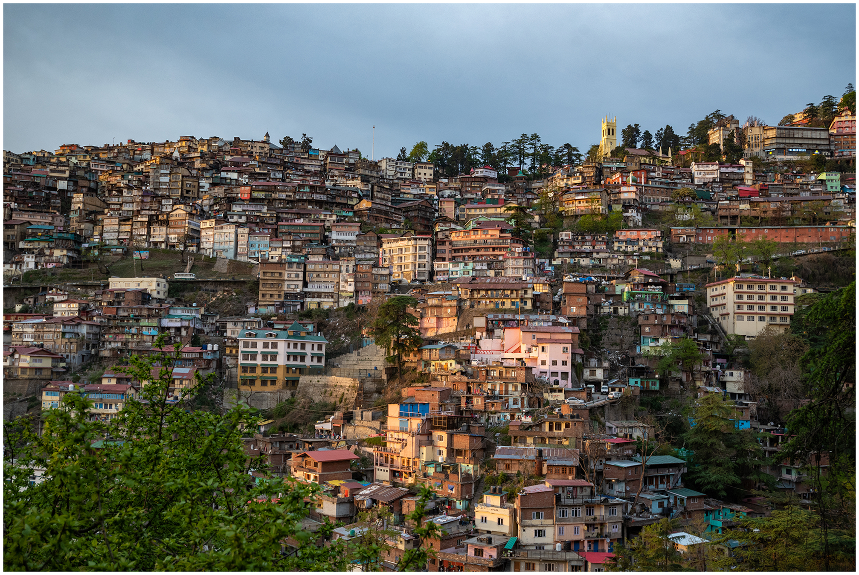
Shimla hillside showing the Imperial capital at the top of the hill and Krishna Nagar below Cart Road. Photo: Rohit Madan, 2018.
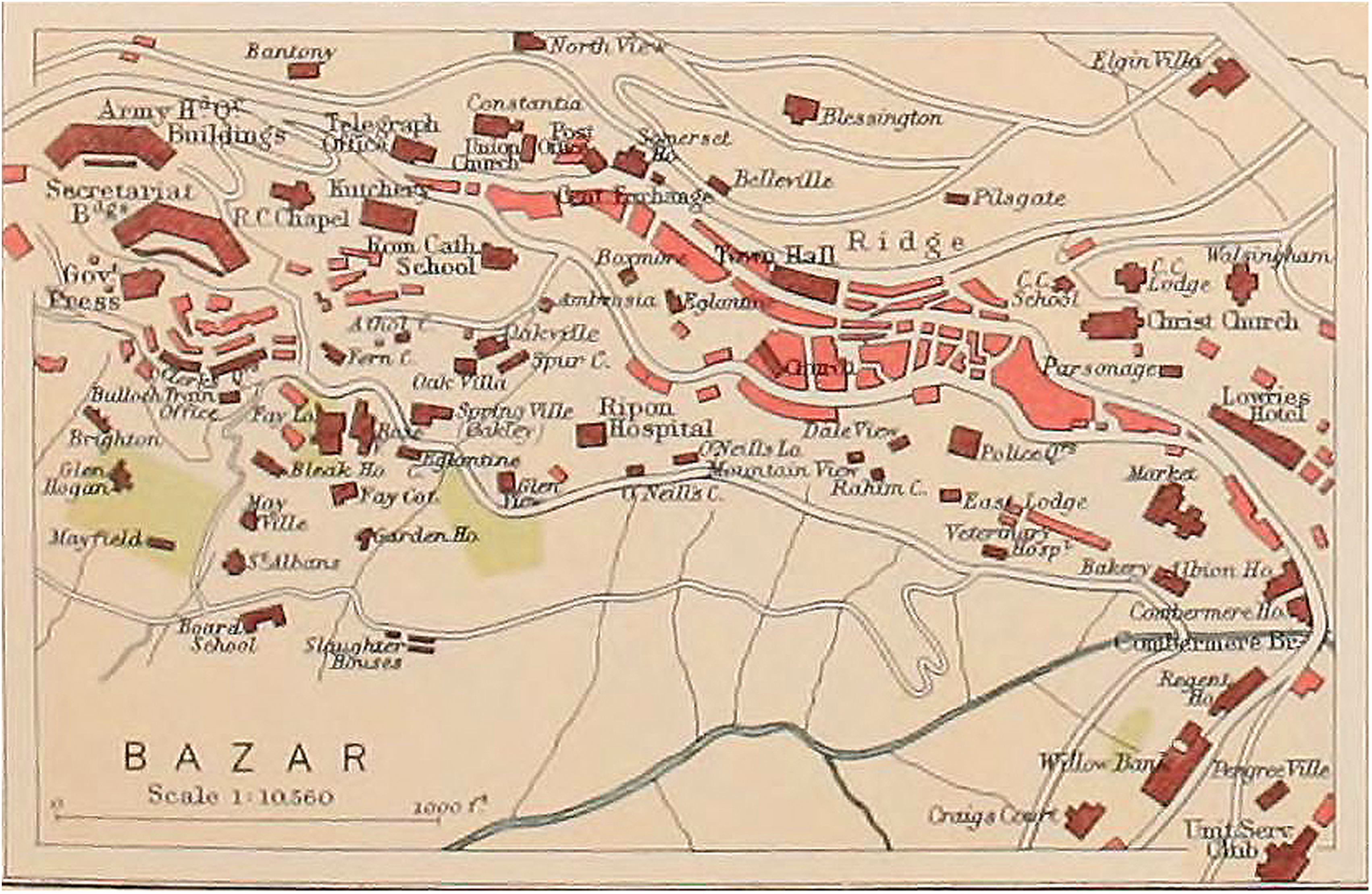
Archival map of Shimla in 1911 showing only slaughterhouses below Cart Road. Source: British Library.
In the records, although neighbourhoods ‘Below Cart Road’ are nameless, individual case files however, refer to a rich tapestry of ethnic and regional geographies in the hills – a Slaughterhouse, [animal] Skin godown, Municipal Sweepers’ quarters, a ‘Ladakhi Mohalla’ (settled by Shia Muslims from Ladakh), and a ‘Baltistani Mohalla’ (settled by Muslim migrants from the Punjab). The files also mention a ‘Singh Sabha’ (Sikh Temple) on Cart Road built for Sikh migrants from the Punjab. The distant time of these mohallas [neighbourhoods] where people by ethnicity or vocation were connected through a web of coloniality, ecology, and technology tell the story of a rich multicultural heritage in Shimla that has been obscured by the imperial stories of grandeur from above, recounted by colonial and postcolonial historians alike (Bastavala, 1925; Buck, 1925; Pubby, 1996). Names of owners with their occupation as last name, such as Abdulla Tailor, Allah Bux Butcher, and Bunna Sweeper, prominently printed on the cover of each case file suggest the multitudes of subject positionalities within a working class identity that were kept at a distance by the colonial municipality. Each case file is a house biography, reflected in the incremental building applications. Each house started as a small one room dwelling, then it was incrementally built over many years till they became double or triple storey residential buildings sometimes subdivided and occupied by multiple families. They reflect biographical events in the lives of their owners – growing families, new livelihoods, economic hardships, or moments of prosperity are mentioned in correspondence with the Municipality. Early Shimla was built on the labour of Muslim, Dalit, Punjabi, and Kashmiri migrants coming from villages across the northern Himalayas. They found work, maintained livelihoods, and settled with their families and in order to do so, used the Municipal building applications as a route to long-term inhabitation along the precarious slopes of the hill.
The case files present us with an image of native time as distanciated from the state, collected in bursts and spurts, going through cycles of suspension, delays, and destruction. Each case file maps the cyclical time of seasons and natural disasters through repeated building activity around repairing and extending homes, and they map the ways that temporal impermanence and advances in construction technology produced a dynamic relationship with ecological precarity. Building applications draw attention to the cyclical time of earthquakes, monsoons, and landslides, requesting permission for – stabilising hillsides with retaining walls, covering verandahs, inserting concrete and steel as building supports, shifting from lime to cement mortar, introducing bitumen for waterproofing and so on. The correspondence reveals concerns for water ingress during monsoon rains, or repairing a building damaged by landslide, or rebuilding collapsed buildings with stronger foundations – repair and rebuilding was the everyday temporality of lives down the slopes.
Technological development was an important aspect of survival under ecological uncertainty. Incremental building was spurred through advances in building materials and methods of construction. The early houses were constructed of tin sheets, then new applications were made to enclose with brick walls, then another application would request the addition of iron and asphalt; later there would be another application to add bitumen and concrete for waterproofing the building. Another application would be added later to cut into the hillside to build a retaining wall and further one to add a toilet. Once the ground floor of the building was strong and secure against the hillside, a new application would be made to add an upper storey to the house for a growing family or to generate rental income.
Reading ‘along the grain’ of the case files ‘Below Cart Road’, it is apparent that the colonial state aimed to bolster a new municipal power that was required to monitor, regulate, and maintain temporal distance between ‘native’ building activity down the hill and the British Summer Capital at the top of the hill. In the meticulous documentation, the most significant indications of how municipal power regulates temporal distancing emerged from the handwritten notes between different officials of the municipality – the Secretary, engineer, health officer, surveyor, patwari and others – commenting, debating, and taking decisions on the future of each house down the slope. Temporal uncertainty was maintained by frequent spot checks and surprise inspections. The engineer or surveyor would make detailed comments about their observations on site, sometimes including subjective notes about the personalities of the residents. Sometimes these notes provided a justification for the Municipality to issue notices or demolition order, or even take some residents to court for repeated building violations. Taken together, these files construct what Mitchell has noted as the ‘infrastructure of delay’ (Mitchell, 2020) – they enabled the municipality to delay and even suspend urbanisation down the slope.
Despite the evident assertion of municipal power in the building applications, the correspondence between natives and the municipality, and in particular owners’ responses to notices, penalties, and demolition orders suggests a much more layered and complex story of temporal negotiation, subversion, manipulation, and obstruction. Case files ‘Below Cart Road’ show a refusal to conform to the timelines of planning that were imposed by the colonial municipality from above. Each correspondence from owners reveals a story of ‘longing and appropriation’ (Steedman, 2002: 81) of temporal economies in building their houses against all odds – social, economical, administrative, topographical, and ecological. This is particularly evident in one very thick case file (#1085x) named Abdulla Contractor and annotated as ‘Application to build a house below Slaughterhouse’.
After Abdulla Contractor (Figure 3, Case file #1085x) moved into ‘Ladakhi Mohalla’ in the late 19th Century, he wanted to build an Imambara (small mosque) for Shia Muslims in 1911. In his application to ‘Simla Municipal Committee’ (MC), he was anxious to assure that this building was not for the purposes of making any income but only for religious activities. MC refused to approve this application since he did not provide detailed plans, to which Abdullah pursued with a further application asking for an ‘act of kindness’ to grant permission. This was subsequently granted since the accompanying drawings were in order, although the Resident Engineer wrote a memo to the Assistant Secretary that ‘it is a mistake’ since MC has refused similar applications and in view that the future of the area was uncertain as the SIT report recommended redevelopment of this ‘unsanitary’ area. Abdulla therefore gave an undertaking on stamped legal paper that the building would only be used for religious purposes and that he, his successors, heirs, or any representatives of the Shia/Sunni community would have no rights to the Imambara if the MC needed to acquire it at a later date. Four years after the building was built, however, Abdulla was found in breach of this undertaking. The Assistant Secretary of the MC found that one room in the Imambara was being rented out to five ‘Ladakhi coolies’ and another was being used as stable for horses. In a memo the Engineer wrote, ‘the passage between the 2 houses (partly covered in) simply reeks with manure. I think surprise inspection is necessary’ (dated 12/8/1914). The MC immediately initiated an injunction against Abdulla, who argued that the lower floor was occupied only by a caretaker. The MC responded that unless a window is provided, it will not be deemed for human habitation. Abdulla promptly added a window and so begun the official conversion of the Imambara into a residential property. Subsequent owners in 1932 demolished the Imambara and built a three-storey residential house with basement quarters for coolies.
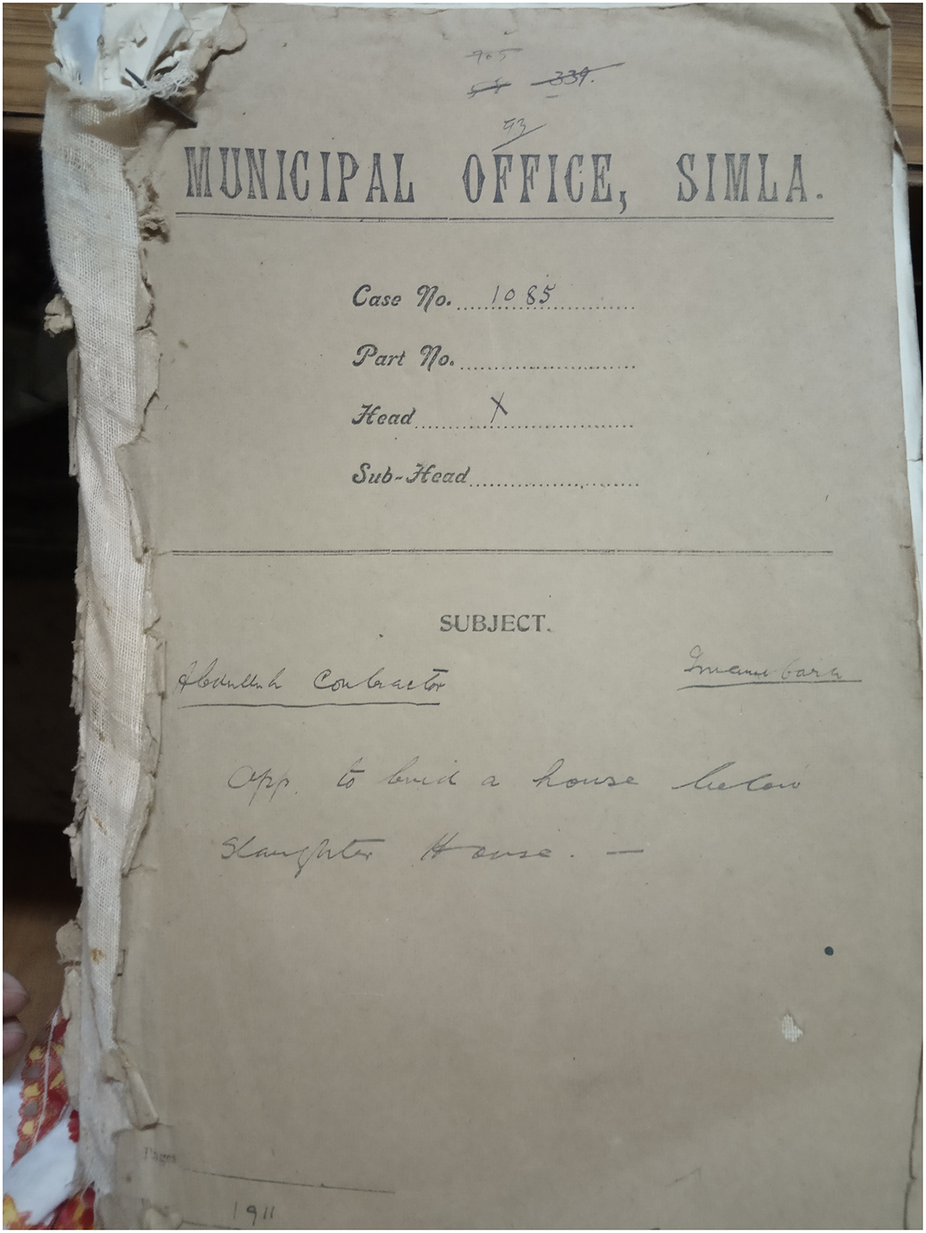
‘Abdulla Contractor’ house below Cart Road, case file 1085x. Source Shimla Municipal Records Room.
Such back and forth correspondence was very common as residents would provide arguments around the legality of their housebuilding, whilst the MC would continue to challenge these claims. The MC refused several building activities especially when they were deemed to have violated regulations or showed unauthorised construction. In most cases, residents would ‘buy time’ by engaging in temporal subversion. One file (Case file #445X) labelled ‘Kalicharan Ganguli’ stands out in this context. From the correspondence, it seemed that Kalicharan was a Bengali migrant who duped the MC for a period of time by claiming that the house with unauthorised additions was not owned by him. In the meantime, ‘Nanki Must’ a woman living in the house claimed she was Kalicharan's wife and that the house was hers, although Kalicharan never mentioned her in his correspondence with the MC. Memos between the Engineer, the Health Officer, and the Assistant Secretary of the MC reflected a level of confusion. Whilst they referred to her as ‘the lunatic woman’ and they suspected that she was a tenant, they were not able to prove this. Upon investigation in the Shimla Tax and Revenues department, the municipality was informed that the house was not registered to Kalicharan, which for some time led to them issuing notices to a different person. By the time, the municipality did detailed checks and found out that the house indeed belonged to Kalicharan; he had already subdivided the house and sold it off. These new homeowners were then threatened legal action by the MC for Kalicharan's unauthorised constructions.
Another file labelled ‘Abdullah Tailor’ (Casefile #39) reflected the subjective nature of distant time in the hills. Abdulla Tailor applied to the MC for permission to repair his walls because they were heavily damaged during the monsoons. This was because the main religious structure near his house – the roof of the Singh Sabha belonging to the Sikh Community – was draining water on his house. The initial sanction was approved provided he did not make any structural alterations, but later a site inspection from the MC Engineer revealed that he had added two stone walls under the roof and enclosed it. The MC gave him five days’ notice within receipt of letter to remove the unauthorised construction. Yet despite two notices, Abdulla did not comply and was prosecuted in a criminal case. The District Magistrate found him guilty and fined him 5 rupees. After paying his fine, Abdulla first applied to purchase the land on which his roof was overhanging from the MC. Two years later he applied again to the Engineer MC to repair his walls. It was around the same time that the MC received a complaint from a neighbour against Abdulla. … so for the benefit of the government, I beg to inform you that a severe notice should be taken immediately, after sending a European Officer to inspect the place, or it should be inspected by you personally, as I fear about the native whether he will see properly or not. [File #39, letter dated 13/2/1910]
This was a construction of distant time through a temporal distancing of migrant subjectivities from each other. Whilst Abdulla Tailor's neighbour did not trust the judgement of anyone but a ‘European Officer’ the MC nonetheless sent a ‘native’ – a Mr Basant who noted that unauthorised construction had indeed taken place. The MC then received another letter from a neighbour alleging that Abdulla had extended his house again by putting a downpipe over a piece of land that did not belong to him. This time the Patwari (land records officer) went to measure the house boundary and found that the boundary had indeed been extended without authorisation. To this report Abdulla replied, I am at a loss to understand as to who has been addicted to make such unfounded reports against me as the ones detailed in your letter. The downpipe in question was put in at the very outset, namely the construction of the house.
Abdulla also argued that the downpipe was on a piece of land that was sold to him by the municipality and therefore rightfully belonged to him. There is no follow-up correspondence on this, but 4 years later Abdulla applied to install a gate for protection against his lower caste neighbours. In the beginning of the month, during the period of severe cold, Municipal sweepers living in the sweepers quarters below Singh Sabha committed theft having stolen a part of the fencing of the compound of my house along with some windows.
In 1933–34 there were another series of exchanges between Abdulla Tailor and the MC, this time again alleging that he is making unauthorised constructions and extensions to his house, which he strongly denied. He repeatedly requested the Secretary (who was British) to come and pay a visit himself so that Abdullah can explain that the work is merely to replace and repair the walls as is. He went onto claim that a ‘hard line’ is being taken against him by the engineering department of MC and he is therefore being discriminated upon as Muslim. Further I add here for your information that I am always prepared to substantiate the allegations which have been made hitherto in my correspondence on Municipal affairs in general, the totous [sic] and adversary attitude adopted against Muslims by certain employees of the Engineering Department in particular.
What transpires from another file (Case #40) also labelled Abdulla Tailor was that he did not reside in the house named after him in File #39. His residential home was in fact above Cart Road, in an area near the bazaars called Edwards Gunj. He simultaneously submitted another application to rebuild his main residence in Edwards Gunj from a 25 feet high three-storey building into a 41 feet high four-storey house cut into the hillside, with concrete floors and cast-iron downpipes and galvanised iron roof sheets – signs of affluence in those times. This was also rejected by the MC.
Abdulla's story shows how the subjective positionality of each native is also temporally distanced from each other even as they all collectively defy and subvert colonial temporalities from above. For the ‘native’ – time was the resource to make their way socially and physically up the hill. They stalled, delayed, and speeded up housebuilding when it was possible, through subversive or direct methods. But their correspondence also suggests that distant time was mutually constitutive of native and white settler temporalities as they used planning temporalities to recoup their assets from ‘difficult’ neighbours.
These stories are testament to how ‘bare life’ (Agamben, 2008) at the bottom of the hill desired to reach the top to be recognised as human. They show how migrants since the colonial period built and expanded their houses by stalling, complaining, bypassing, negotiating, and complying with the state which maintained temporal distance. Over time then, some homeowners below Cart Road became more prosperous with Shimla's rising prosperity. For example, by the 1930s Abdulla Contractor (CaseFile #1085x) owned a number of buildings and godowns in Shimla. Similarly, ‘AllahBax Butcher’ (Case File#54) built his first house near the slaughterhouse where he worked in 1886 and finally after 30 years, owned a shop on Mall Road (at the top of the hill) importing British shoes and boots. The rise and prosperity from being a tailor or a butcher to becoming a landlord and shop owner on the Mall in the heart of the British Empire suggests that theirs was not simply a life on edge; it was a continually changing life along a sliding slope where prosperity was literally linked to making a house more resilient to nature and achieving spatio-temporal proximity to the top.
In the case files, there is a gap in house biographies for 10–15 years between the 1940s and 1950s. In the case files, the names have changed after India's independence in 1947. The Muslim names in the files – Abdullah, Allah Bux, Moula Buksh, and so on – are replaced by Hindu names reflecting the wider geopolitics and partition of the subcontinent into India and Pakistan along religious lines. This forms a crucial snapshot of Shimla's future as several Muslim residents left Shimla, and their vacant houses were occupied by Hindu migrants during this time. Change of occupancy, however, did not always translate to a formal change of ownership, and this ambiguous ownership profile of much of the area below Cart Road laid the foundation upon which Shimla's aspirational smart future was going to unfold several decades later.
‘Below Cart Road’ is now called ‘Krishna Nagar’ – a new name but with a continuing embodiment of distant time. Krishna Nagar has expanded far beyond its original footprint with fourth generation descendants of migrants, as well as new waves of migrants coming from neighbouring villages and farther, looking for livelihoods in a thriving tourist town in the region. The persistence of early settlers is etched into the slopes of the hills, in the stairs and pathways leading down the slopes to their houses, in the foundations and retaining walls of houses that have long been demolished and built upon or expanded and extended. Even as the case files uphold the colonial state engaging in temporal distancing, they also narrate the story of multitudinous subjectivities surviving against all odds and that aspirations of Shimla's smart future are to be found in the dust of that empire down the hill.
Krishna Nagar: A striated distant time of the hillside
After Indian independence in 1947, Shimla became the capital of the regional state of Punjab and in 1966 was incorporated as the regional state capital of Himachal Pradesh. In 1979, the Municipal Corporation prepared its first Interim Development Plan closely followed by the constitution of the Shimla Development Authority in 1980. Since then, the development plan has been updated and amended to reflect the nature of issues posed by ongoing urban development in the city. Shimla's urbanisation has accelerated since the 1980s reaching about 50,000 in the 2011 Census. In 2016, the city published its first integrated report on risk management, hazard mapping, and assessment of vulnerability in the physical, economic, and social environment.
Krishna Nagar is now a designated ‘Slum’ under the Himachal Pradesh Slum Areas Act of 1979, but it has never been a homogeneous mass of working class residents that could be prescribed a ‘common’ future. Indeed, Krishna Nagar now constitutes a striated geography of distant time along the hillside (see Figure 4), with distance from Cart Road determining a hierarchy of socio-temporal ordering. The neighbourhood of ‘Sikh Lines’, located below Singh Sabha on Cart Road consists of a row of around 15–20 houses mostly inhabited by Sikh families. Our participants there did not consider themselves to be part of Krishna Nagar. Located immediately below them, the ‘New Lines’ building comprises of 12 rooms over two floors allocated to Municipal sanitation workers’ families, who belong to the lowest castes. Below New Lines, the Ladakhi Mohalla neighbourhood is now renamed ‘Luv-Kush Chowk’, and the stretch of the road from there connects further down to Mandyal basti, where Dalit migrants who used to clean Mall Road settled during the colonial period. Many of them are now employed as door-to-door garbage collectors, sanitation workers, and construction labourers. From here, the road gets steeper and more slippery going further down to the edge of Krishna Nagar. At this point, there are no stairs but unstable rocky steps leading to the bottom of the hill on Shimla Bypass Road where a new mechanised abattoir was constructed in 2014.
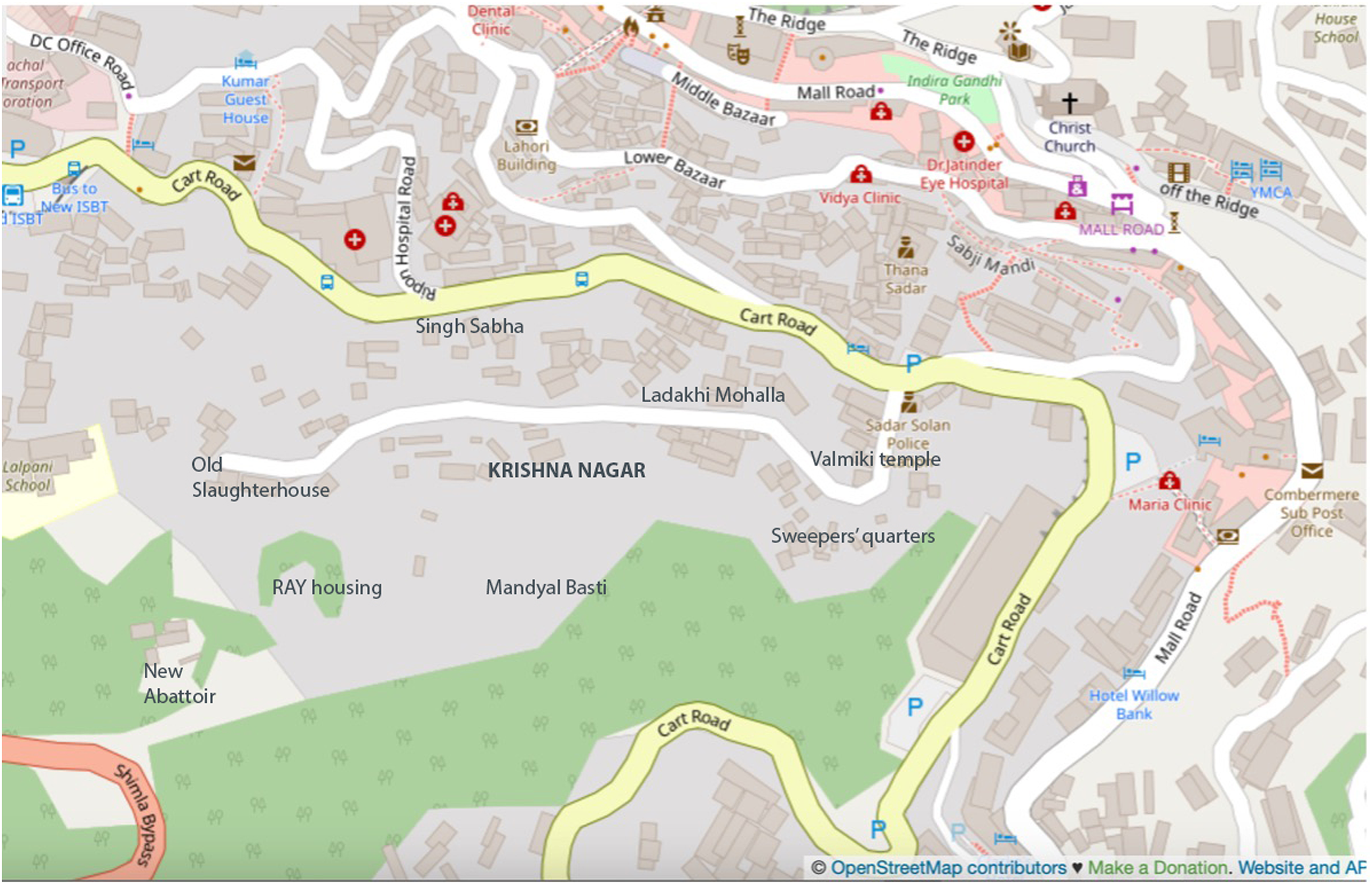
Openstreet map of contemporary Shimla. Neighbourhoods added by author.
Krishna Nagar thus charts a multitude of distant times along the contours of the hill slopes where the most vulnerable social groups occupy the most precarious landscapes. They are socio-temporally and materially distant from each other, as their connection to various parts of the hill and to Cart Road is subject to their spatio-temporal distancing from each other and from Mall Road. This also determines their differential access to water, electricity, and sanitation. In 2013, a report by the Himachal Regional Government identified Krishna Nagar as a ‘Pilot Slum’ and initiated actions to prepare a ‘Slum Free City’ plan. But the same year, a landslide caused major damage and destruction to buildings and infrastructure in Krishna Nagar. It was reported that close to 200 families were rendered homeless, but the most damage was caused in Mandyal Basti, one of the lowest and most precarious neighbourhoods. As one of the survivors narrated. A building located above fell first. Then the police and fire brigade came to our homes and made us evacuate to the other side. Because the roads were closed it was difficult to move all our belongings. We had to lay down an alternate temporary path ourselves to move. We stayed in Ambedkar Bhavan [Community Hall] for four to five months. Hundreds of us. Then slowly we put our savings together and started rebuilding our homes. [SI051]
After the landslide, there were several applications for building new houses in Krishna Nagar, but most of these were rejected by the Municipality unless they were rebuilding the same house over existing foundations. Like the colonial municipal applications, Krishna Nagar was presented as disorderly, unsanitary, and uninhabitable and therefore living on borrowed time and awaiting demolition and rehabilitation. In 2013, under the Rajiv Awas Yojana (RAY) – a central government scheme for housing provision – construction began on a new four-storey block of flats at the bottom of the hill, literally layered over a colonial era children's graveyard. The flats were 8 feet × 8 feet in size, smaller than most houses in Krishna Nagar and therefore, unacceptable to its residents. Construction on this housing was not completed as cracks emerged due to the National Highway widening project near the Bypass Road.
Smart urban futures from above and below
On a warm summer evening in Delhi, I met with Shimla's smart city consultant to understand how the proposal came into being. The consultant explained that they had been commissioned to produce a Smart City masterplan within three months – a challenging prospect from the start given its timing in peak Winter. During the first visit to Shimla, the design team found themselves unable to return to Delhi due to record snowfall that year. This made them very aware of temporal distances between the top and bottom of the hill as snow made even small journeys challenging. One evening whilst out in the Lower Bazaar they saw a building standing without a supporting column. There was one building and I saw one column dangling. I’m an architect … I really got scared. I said, we’re here doing smart city. Things gonna fall apart. If one falls, it will be like a – zzzz –domino effect and the whole city will go in one shot. I’m telling you this even now, it's dangerous. … That's it. That was the day we said, forget it. The only programme that the smart city has to be focused on is this. … the entire built stock must go.
This was a radical proposal, which faced opposition even from within the design team. Nonetheless they found support for this within the Shimla municipality. It's better to do that little surgical [strike]…whatever you call it…and start fixing the problem. Then, luckily when we talked to the [municipal] official, we told them, figure out this now. Tell us whose land ownership da da da da… So, next what they told us is, the whole thing is government land.
As Rovelli notes, ‘It is the presence of abundant traces of the past that produces the familiar sensation that the past is determined. The absence of any analogous traces of the future produces the sensation that the future is open’ (Rovelli, 2019: 145). For the smart city consultant, traces of the past were present in the buildings in Lower Bazaar and Krishna Nagar. They produced a sensation that the past was in distant time, as disorderly, unauthorised building activity since the nineteenth century in places far from Mall Road that continues to pose the risk of total structural collapse into the extended future. If land in Krishna Nagar was officially under Municipal ownership, it was assumed that it would be legally less tedious and challenging to demolish ‘unauthorised’ buildings to make way for future rebuilding. The future smart city was going to emerge from the rubble of incremental housebuilding since the nineteenth century.
Here temporal distancing works through objective metaphors such as ‘surgical strike’, since as Fabian notes, ‘labels that connote temporal distancing need not have explicitly temporal references (such as cyclical or repetitive). … temporal distance is objectivity in the minds of many practitioners’ (Fabian, 2014: 30). Krishna Nagar as a place down there and ‘stuck in time’ was the perfect ‘terra nullis’ for a ‘surgical strike’ from above. Like the SIT Reports of the early twentieth century, Shimla's Smart City Proposal (SCP) aspired for a future that was more resilient to natural disasters, transforming its identity into a ‘Clean, Serene and Vibrant’ (Ministry of Urban Development 2019) city.
In 2019, the Smart City proposals revealed a total of 53 proposed development projects spread across three categories – (i) pan-city projects that included digitisation of land records, citywide GIS mapping, and installation of CCTV cameras; (ii) retrofitting of existing infrastructure including mobility improvements in junctions, roads, foot overbridges, as well as construction of lifts, escalators, and tunnels, and (iii) Area Based Development (ABD) projects that included ‘48 acres of Lower Bazar, Gunj, and Krishna Nagar and capitalizes on the opportunity to replace dilapidated and unsafe building stock with new resilient, modern, earthquake safe, smart green development, unlocking its full tourism potential’ (43). The proposal revealed plans to conduct a complete demolition and redevelopment of Lower Bazaar and the hill slopes below Cart Road to construct multi-storeyed housing for eligible Krishna Nagar residents, a new slaughterhouse, and a school amongst other buildings. The proposal further justifies this approach by noting that ‘presently the area selected has worthless dilapidated buildings with priceless views’.
This, here, is the articulation of distant time. As Fabian suggests, distance is a ‘naturalized–spatialized Time which gives meaning (in fact a variety of specific meanings) to the distribution of humanity in space. … such use of Time almost invariably is made for the purpose of distancing those who are observed from the time of the observer’ (Fabian, 2014: 25). The smart city proposals separated those of more and less value through a capitalisation of temporal distancing – priceless views versus worthless building stock, tourist economies versus working class livelihoods, unsafe building vs. earthquake resilient housing, dilapidated vs. green building. In these plans, Krishna Nagar homes were marked for demolition as they were judged to be ‘worthless’ from the top by smart city consultants and the municipality. In this scheme, working class houses are demolished; their families are removed and resettled further downhill near Shimla Bypass Road in the multistorey RAY housing scheme where construction had stalled since the landslide in 2013. This however is also an uncertain future as eligibility criteria for allocation of these houses are connected to a proof of long-term inhabitation through a ‘Certificate of belonging’ issued by the Municipality. As one participant noted, We are all scared what if they demolish our houses. Where will we go then? … The British had bought us Punjabis initially to clean the city. And now they have left, what will happen to us? … They [Municipal officers] say that we have encroached upon this land. How can you call a 4th generation an unauthorised resident? [SI043]
For Krishna Nagar residents, the past is what Hartog notes as ‘a type of time which lasts, a time of trauma … which resurfaces at certain moments. It is a kind of immobile, involuntary present’ (Hartog, 2003: 202). Here trauma is felt through the distant time of the colonial empire where incremental housebuilding is repeatedly identified as unauthorised creating afterlives of ‘otherness’ even for a 4th generation resident. Here distant time is felt as frozen since particular subjectivities are kept in enhanced temporariness across generations through a denial of primary assets – land, housing, livelihoods, and so on. In Krishna Nagar, this is socially striated as most Dalit and Valmiki communities did not own any land or had documentation of eligibility for state housing. As one Valmiki community leader noted: The entire Valmiki community in Shimla is landless. No one has any land. Not even one bigha [unit of land = 2.5 sqm]. We have a lot of problems because of that. All of the Valmiki community, they have put it in all their capital in all this [land]. So our thoughts are that our community should be settled, where we have stayed, forever. Even now, we have not been able to clear our bank loans, so our main demand is to regularise the houses where we have put our money, or you [municipality] make new homes for us. [SI032]
Simone notes that ‘trauma is not history but rather an unrepresentable event or era that gets endlessly repeated and goes nowhere except through its fixation to particular objects or ideals’ (Simone, 2024: 108). Even as an assemblage of laws, policies, and reports have been mobilised to cleanse Krishna Nagar of its ‘outsiders’ since the colonial period, construction activities for increasing mobility infrastructure under the smart city projects have increased the frequency of landslides and therefore further reinforced the precarious future of its current residents. Yet the temporalities of incremental house building recorded in the Shimla Municipal Records room since the late nineteenth century reveal that the taxonomies of informal and unauthorised housing are not definitive and that these denotations are constructed by those in power on Mall Road and challenged from below Cart Road. As one participant argued, You [Municipality] say you want to end slums? There are unauthorised houses in Krishna Nagar? You think we will leave our livelihoods so easily? You will have to fight it out with us. It will take 2, 4, 5 years for that. … Then we will go to court. It will take 25 years. When will the smart city be made?
For Simone, temporariness ‘is not simply a problem to be solved. Rather, it is a register to be cultivated; a rhythm of endurance’ (Simone, 2020: 12). The question – when will the future smart Shimla be made? – shows how Krishna Nagar residents propose to use resistance and judicial interventions as strategies of temporal arbitrage. Similar to the colonial municipal records these strategies of waiting and negotiations with municipal officers are repeatedly deployed during site visits. Residents also use technologies of building construction as temporal arbitrage to suggest the extended temporalities of building in the hills. if you are going to build houses in the plains – that's a different matter. In the hilly area of Shimla, the methods of construction are different. This is not like bringing a bulldozer, uprooting the house and start building from the base again. This is not possible here. Pillars must be set, above them the beams, the beams have to supported from top – only then the building would stand. [SI029]
In these arguments, temporal arbitrage is seen in the evocation of ‘countertempos’ (Barak, 2013) of technology and ecology that makes Shimla's smart future slower to arrive in the hills. Arguments around a slow ecological crisis unfolding in Shimla because of increased building construction in the last few decades were taken as temporal obstructions to the emergence of a smart city in the future. Because of all the (road) blasting below near Bypass Road, the rocks were disturbed. Water has entered the cracks and work has stopped [on buildings]. For ten years now, no one has even dared to lay a brick. Apart from the blasting you have all these drains which keep pushing water in people's homes. [SI043]
A participant thus noted that even though the smart city will be conceived from above, it can only be built from below. What can be construed as a reversal of a smart city seen from above, this participant asserted the spatio-temporalities of Krishna Nagar as a foundational moment in Shimla's rise and significance as a tourist town vital to the regional economy. for a smart city, first of all, it has to be built from bottom to top. You cannot begin to build on Mall Road and then keep going down. This is not possible. … No building starts from being constructed from the top, the beginning is always at the bottom. The foundation has to be strong for you to reach the top. [SI029]
Asking to ‘build the foundation first’ turns Shimla's temporal distancing on its head, suggesting that temporal ordering needs to start from below. This was seen in the temporal impasse that followed when a ‘concerned citizen’ filed a Public Interest Litigation (PIL) with the National Green Tribunal (NGT) raising concerns about an impending ecological crisis due to the impending building activity of Shimla's smart city projects. This PIL can be understood as a form of temporal arbitrage of delaying from below when the subsequent NGT order in 2017 banned activities on Shimla's smart city projects in Krishna Nagar and Lower Bazaar. In 2021, the Himachal government approved the future Development Plan 2041 for Shimla which was also stayed by the NGT in 2022 citing environmental concerns. However, this was recently overturned in 2024 by India's Supreme Court which accepted the State's argument that ‘due process’ of citizen consultations had taken place before its Smart City proposal and Development Plan had been approved (Express News Service, 2024). Whilst the temporal asynchronicities between judicial orders and executive challenges are beyond the scope of this paper, it is worth noting that they have slowed down full implementation of smart city projects thus far. Nonetheless the Himachal State and Shimla Municipality have continued smaller, fragmented demolition and building activities below Mall Road.
The future of urbanisation from there and then
In this paper I developed a notion of distant time as a tool of statecraft that is simultaneously engaged in cartographic, social, and temporal ordering, but that is also reimagined from below through various forms of temporal arbitrage and claims to temporal justice. Distant time provides temporal distance between the colonial empire and its native subjects, colonialism and postcolonialism, development and ecological devastation, ‘unplanned’ urbanisation and smart urban futures. Distant time is also a temporal space of survival where a ‘native’ subject emerges from the letters, memos, and handwritten notes describing the rocks, foundations, retaining walls, pipes, and the slow incremental house building down the slope. These houses might crumble with the landslides, crack with the earthquakes, wash away with the monsoons, or demolished to make way for a future smart city, but they embody the labours of the migrants, Muslims, lower castes, and working classes who till this day engage in continuous cycles of building, repair, and rebuilding.
Referring to the archival process, Steedman noted that the cyclical nature of ‘dust’ is ‘about circularity, the impossibility of things disappearing, or going away or being gone. Nothing can be destroyed’ Steedman notes (Steedman, 2002: 164). Distant time is also a metaphor for dust in Shimla, where nothing ever ends, and everything returns in another form in another time. Dust of the colonial archives is heavy with forms of temporal arbitrage from below Cart Road that continues to this day to claim temporal justice in the smart city of the future. Distant time in Shimla is seen in the circular nature of ecological temporalities that are exacerbated by the cycle of technological advances which seek to stabilise the ‘disorder’ down below. Distant time is the dust of the empire from above that settled on the native down below and the dust that will be left behind from generations of native settlement to establish a smart city in the future. Distant time then highlights the temporal entanglements of people, ecology, and technology not in any predictable causality of time or space, rather in all the ways that this entanglement continues to shape memories of the past, experience of the present, and anticipation of a different future.
As Hartog notes ‘The future is a time of disasters, and ones we have, moreover, brought upon ourselves.’ (Hartog 2003: xviii) Tracing the connections between colonial early twentieth century urbanisation and twenty-first century smart urban aspirations offer us a way to see the past, present, and future as fragmented assemblages of temporal ordering. The distant time of future ecological disasters in Shimla is deeply entangled with the distant time of colonial urbanisation. This is not to say that these are the only two moments of significance, but connecting urbanisation across time and distance enables us to understand how both the colonial and postcolonial states have always maintained ‘proper distance’ (Silverstone, 2003) from subaltern subjects in ‘proper time’. Distant time is a strategy of keeping the subaltern subject in wasted time, whilst they also cope with the cyclical and attritional time of ecological disasters such as landslides and earthquakes. Distant time underlines the continued significance of ecological decay, delay, and destruction in challenging the ahistorical fantasies of smart cities, which have rarely engaged with the political–technological nature of temporal power and the forms of temporal arbitrage embedded in urbanisation.
Footnotes
Acknowledgements
The author wishes to thank all the participants of Krishna Nagar, Shimla Municipal Records Room officials and smart city consultants who gave their time towards supporting the archival work and answering interview questions. The author also appreciates the work of research assistants - Mahima Taneja and Varun Patil in data collection as well as the support of colleagues on the 'Learning from Small Cities' project (Read full project report here: ![]() ). Finally the author is grateful for the comments and feedback from three anonymous reviewers which have vastly improved this paper.
). Finally the author is grateful for the comments and feedback from three anonymous reviewers which have vastly improved this paper.
Declaration of conflicting interests
The author declared no potential conflicts of interest with respect to the research, authorship, and/or publication of this article.
Funding
The author disclosed receipt of the following financial support for the research, authorship, and/or publication of this article: This work was supported by the Economic and Social Research Council, (grant number ES/R006857/2).