
Abstract
This article extends work in human geography on thinking space relationally and topological space, arguing for a relational conceptualization of space that employs montage in small seemingly confined spaces to tell big relational stories. Empirically it explores a micronation projected onto watery western Balkan no-man's [sic] land and reveals an exploitation of Balkan history and geography that underpins perceptions of the southeast European peninsula. Liberland is a new right-libertarian unofficial country that claims a disputed tract of middle Danube riverbank in a contested riverine borderscape between Croatia and Serbia, where the fantasy geography of emptiness and terra nullius reappears in a new imperial present. The hackneyed performances that self-proclaimed micronations undertake to legitimize themselves are placed alongside a relational story of regional cultural landscape and more-than-human geographies in this fluvial political–ecological borderland in order to undermine alt-right libertarianism, Balkanism, and imperialism.
Keywords
(Pre)facing the geographical imagination: (Re)writing the Balkans
It is 13 April 2015, and in a largely forested seven square kilometer teardrop of marshland called Gornja Siga on the western bank of the middle Danube, a small group of libertarians are about to plant a flag. With this symbolic act drawn from the imperial imagination, they claim a little riverine territory disputed since 1947 and disclaimed by the riparian states following the dissolution of the Socialist Federal Republic of Yugoslavia (SFRY) in 1992 (Klemenčić and Schofield, 2001; Silber and Little, 1996). With declaratory solemnity, the members of the preparatory committee proclaim their Liberland: We, by virtue of the right to self-determination, right of discovery and the right of self-governance, proclaim the existence of the Free Republic of Liberland. The Free Republic is a free and independent country; and that as a free and independent state, the Free Republic of Liberland shall have the full power to defend itself, conclude peace, form alliances, establish commerce, and enjoy any other rights which sovereign states have. As a member of the family of nations, we pledge to abide by international laws that bind all states in existence (Lewis-Kraus, 2015).
Their self-proclaimed micronation occupies what they claim is terra nullius between Serbia and Croatia. Gornja Siga is an island, orphaned by competing boundary claims, lying beyond the winding cadastral border – which Croatia asserts – and beyond the main channel of the Danube – which Serbia asserts. The result is a small pocket of riverbank and a narrow point bar that neither Croatia nor Serbia claim lest they undermine their possession of other more desirable Danubian adas or river islands on the east bank. Crossing the river from the marshy Siga pocket claimed by the founders of Liberland, two larger disputed patches balloon from the waterway and surround Bački Monoštor – territory claimed by both Serbia and Croatia (Figure 1).
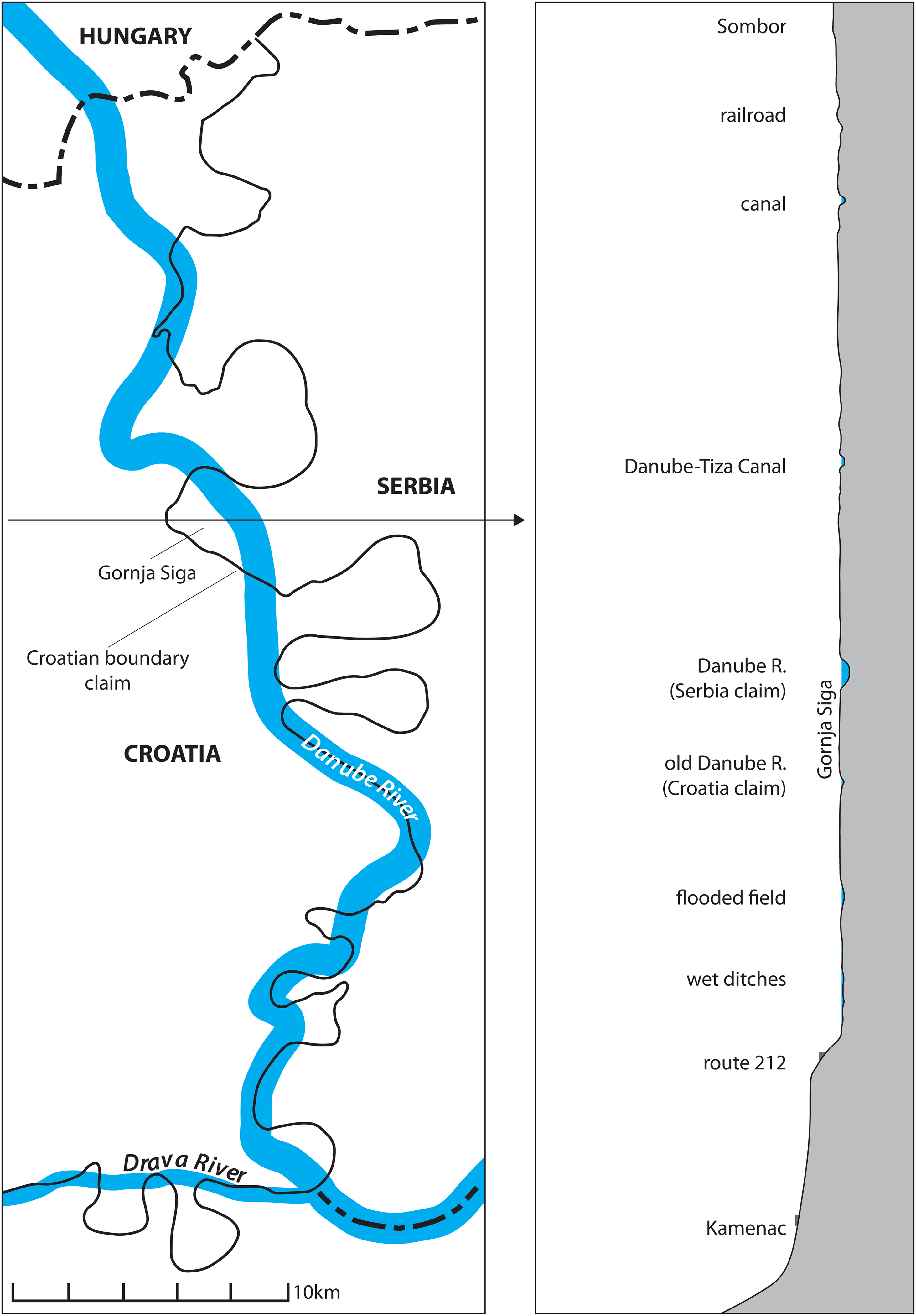
Left Croatian boundary claim follows old cadastral survey before engineering works straightened the Danube River. Serbian claim follows new course of Danube but refuses Gornja Siga (compiled by authors based on Klemenčić and Schofield 2001). Right topographic profile across Gornja Siga flood plain (compiled by authors, vertical scale 30×).
Gornja Siga lies in a flood-prone borderscape that was once the southern Hungarian counties of Baranya (Croatia's Baranja) and, across the Danube, Bács-Bodrog (Serbia's Bačka). The historical cohabitation of Hungarians, Danube Swabians, and various Slavic peoples has given rise to layered toponyms that belie the now official Serbo-Croatian signage. Nearby are the villages of Zmajevac (H: Vörösmart), Mirkovac (H: Keselyüs), Suza (H: Csúza), and Zlatna Greda (H: Bokroshát) in the Croatian municipality of Kneževi Vinogradi (H: Hercegszöllős; G: Weingärten), while Bački Monoštor (H: Monostorszeg) sits directly across the Danube in Serbia on the way to Sombor, the closest city. ‘Gornja Siga’ is a mix of the Hungarian word for ‘island’ (sziga) and the Serbo-Croatian word ‘upper’ (gornja). It was once the site of a village whose residents fled a major flood in 1722, rebuilding across the Danube at Bački Monoštor in Serbia, which today has a majority Croat population. Kneževi Vinogradi, the Croatian municipality that abuts Gornja Siga, is a rural landscape dominated by arable farming, viticulture, livestock breeding, and dairy farms. It is the only municipality in Croatia today with a majority of Hungarians, slightly outnumbering Croats; the once numerous Germans now just 1.8% of the community (DZS, 2013: 45). Since 1991 the area has lost 20% of its population and was targeted for development as an ‘area of special state concern’, not only due to its demographics but primarily because it was under rebel control during the Croatian War of Independence (1991–1995).
In this historically contested region we put into play a ‘Benjamin-inspired version of the montage form’ by ‘intercutting a set of (geographical hi)stories' to de-scribe a self-proclaimed micronation on the watery Croatian-Serbian frontier and to re-inscribe multiple, relational, and heterogenous Balkan pasts, presents, and futures (Benjamin, 1982; Pred, 1995: xiii). The southeast European peninsula where Liberland claims land is known and enframed via ‘the disaster’ of the violent collapse of the SFRY (Blanchot, 1986), and the discursive designators of place are drawn from an ‘imaginary geography of the Balkans' (Goldsworthy, 1998; Todorova, 1997). A repetitive Balkanism takes place, where the region is viewed through an idea that the Balkans is a place of immutable ethnic hatreds outside of a ‘cosmopolitan’ Europe (Nancy, 2000): a place of ‘mindless slaughter on formless ground’ (Toal, 1996). This imagined Balkans can be found in the opening lines of Glenny’s (1999) magnum opus, The Balkans, 1804–1999, where Stoker’s (1897) Dracula is said to be representative of an almost gothic region. In the old Orientalist tradition, it seems as if the Balkans occupies the center of some sort of imaginative whirlpool where every known superstition in the world is gathered (Glenny, 1999). The ‘popular geographical imagination’, as such, plays a significant role in shaping social and spatial thought in and of the ‘fragmented remnants of the former Yugoslavia’ (Pred, 2000: 3). This European region is part of Europe yet is instead known as the Balkans, and like the Baltics and the Caucasus this Othering of regions pinpoints the connection between space, power, and knowledge that has long fascinated human geographers (Daniels, 1992, 2011; Gregory, 1993, 2004; Harvey, 1996; Schwartz and Ryan, 2003). Yet in a ‘new imperial present’, this region is seemingly forever subjected to endless ‘transition’ predicated upon the ‘Europeanization’ of this ‘dependent semi-periphery’ (Harvey, 2003; Horvat and Štiks, 2015).
With this Balkanism in mind, the aim of this article is to travel and write outside of and beyond ontopological geographical discourses through which the representation, conduct, and resolution of wars are sought and through which this region is chiefly understood (Campbell, 1998: 15). We draw upon our previous ethnographic research in the region, and regard the claim to terra nullius on the border between Croatia and Serbia by a right-libertarian assemblage as a performative act that cannot be simply reduced to the purely representational. To submerge their project in this contested fluvial borderscape, we write an anti-imperial ‘spatial montage’ (Buck-Morss, 1989) and reanimate the unfinished compositional project of ‘new cultural geography’ (Cosgrove and Jackson, 1987) when moving through this ‘regional cultural landscape’ (Matless, 2014).
Taking Liberland seriously enables a renewed geographical discussion of imperial imaginaries, in a river valley set between the ambiguous horizontal boundaries of states and the indefinite vertical boundaries of water, land, and sky (Squire, 2016). For it is created within what is cast as the folds of the map, a void where the landscape is seemingly not owned by a state, exemplifying the birth of territory and enabling us to rethink space and relationality, and territory, the state, and sovereignty, in a fluid yet fixed borderland (Elden, 2013a; Painter, 2010). Liberland challenges our thinking of no-man's [sic] land as a zone of indistinction, a peculiarity, or an exception in the present of absolute sovereign power (Agamben, 1998). This is no blank or empty space, but a disputed and more-than-human shifting fluvial borderspace and we cannot overlook what Leshem and Pinkerton (2016), in reinvigorating the category of no-man's [sic] land, have referred to as the social life harbored in such spaces. As we opened with, the swampy human–nonhuman island in question housed a village before it relocated after flooding became persistent, meaning this disputed riverscape demonstrates how water becomes part of the tumultuous processes of modernization, development, and environmental transformation (Swyngedouw, 2015).
In what follows, we expand upon our anti-imperial methodology and ontology by foregrounding the (normally hidden) montaging (and smoothing) that geographers undertake in space, using a fragmentary literary technique to display juxtaposition by representing space inherently as a montage of ‘things, meanings, and practices' (Cresswell, 2019; Pred 1995). Thinking beyond the discipline, we extend debates on space and relational thinking, or ‘thinking space relationally’ (Jones, 2009), in a borderland, intertwining flow-like takes on space, and more fixed takes on space. We express sociospatial relations from a topological stance and acknowledge relationality yet insist upon ‘the confined, sometimes inertial, and always context-specific nature of geography’ performing a ‘moderate relationalism’ (Jones, 2009: 487). We extend the conceptualization of ‘phase space’ (Jones, 2009) and place a renewed emphasis in a virtual present upon digital representation, reanimating ‘the symbolic life of landscape’ (Cosgrove and Daniels, 1988). Space we argue is played-out as montage in an era of mass digital image-making and we use montage to describe space as images affect how we witness, experience, and understand spaces in a now more virtual reality. Increasingly human engagements with space occur through digital encounters, processes, and technologies, from data ‘harvesting’, to platform urbanism, to smart cities, as smart-phone apps direct humans through space and digital interventions reconfigure our encounters with space (Kitchin, 2014). We need new epistemologies and ontologies to reflect this digital change, and this is where montage comes in – through diverse media (writing, film, photography, gaming, mapping) – as a metaphor, a description, an epistemology, and an ontology (for a classic example of montage see Benjamin, 1982).
In reading, thinking, and representing these new immaterial–material, representational–nonrepresentational, and human–nonhuman spaces montagially, we are not interested in ‘smoothing them out, but … juxtaposing and montaging them … so that audiences can work their own way through them, and along the way, inject and make their own critical knowledges out of them’ (Cook and Crang, 1996: 41). The ‘moderate relationalism’, and the ‘fix’ and ‘flow’ that Jones (2009) adeptly describes – the factors that constrain, structure, and connect space – is perhaps a uniquely geographical concern, and this context-specificness is played-out in and through a small space in and on the Croatian-Serbian fluvial border. Here we re-interpret the fixed territorial limits of the state employed by Croatia and Serbia set within the more fluid wider field of forensic more-than-human fluvial historical geography (De Vorsey, 1980). In this fixed yet fluid landscape we interpret the micronation named Liberland as an attempt to bombard space with virtual representations of hackneyed state practices (such as planting a flag or creating an anthem) in order to digitally hack space. To end we return to imperial imaginaries and terra nullius and our anti-imperial fragmentary methodology and ontology, revisiting the geographical imagination in a new imperial present (Gregory, 2004).
For(e) montage in the regional cultural landscape: Towards a new cultural geography
New state projects make clear that a nation state is an act of world-making, and nationality is one of its cultural artefacts (Thrift, 1996). These are cultural processes through which the idea of a nation is built as an imagined community, one which could appear and collapse in the span of a lifetime, as when the idea of unity falls apart from the destruction of a conceived nation (Anderson, 1983; Murphy, 1990). The SFRY was a nation-building project that ‘attempted to create in the potential and actual citizens of a political Yugoslavia a sense of Yugoslav national identity that would overarch and connect the existing South Slavic cultures' (Wachtel, 1998: 5). The repressive apparatus of the Yugoslav project was made evident in late Yugoslav critique, most creatively by the political art collective Neue Slowenische Kunst (NSK) who entered the late-Yugoslav scene by declaring its own state, constructed as an excess of representational and performative acts that uncomfortably synthesized imperial, fascist, socialist, and NATO imageries. Their declared NSK state was purely ideological and transitory, issuing passports at events, including Laibach concerts, and this deliberate blurring of ‘state’ and ‘culture’ challenges official narratives about the tolerance of state authorities in relation to culture. One of the key ways in which the Yugoslav system legitimated itself was the fiction that the state was increasingly tolerant, and absent from cultural and social life (Monroe, 2005: 248).
The representational and performative Liberland has now entered the conflict affected post-Yugoslav scene, by claiming Gornja Siga. Gornja Siga as such presents an opportunity to witness the unfolding of a political imagination on a liminal no-man's [sic] wetland, a momentary state of repose between fantasy and fact. In addition to a territorial claim, Liberland is a performative act and a representational exercise to ‘re-inhabit no-man's [sic] land’ (Leshem and Pinkerton, 2016). Together they comprise a vision for what a (right) libertarian space might look like while at the same time producing tensions with a seemingly ambiguous environmental space, where borders operate as a zone of exception and as a social practice and discourse (Agamben, 2005; Paasi, 1999). We inquire as to how the imagination of free territory outside the system of states can possibly avoid reifying stateness (Ince and Barrera de la Torre, 2016). More specifically, can a new state be formed without relying on imperial strategies that violently conjure a blank space before extending the right of property?
Meanwhile, thinking between kronos and kairos – a consistent time and a break in time – we gaze across waters that rise and spill so often on this Danubian plain, wondering how the construction of an ideological project predicated on the absence of government can sustain itself in a riverscape shaped by forces that have long exceeded the modernist projects of empires, socialist federations, and national republics (Squire, 2016). In so doing, we argue that geographers have a ‘responsibility’ to write anti-imperial accounts and to rethink traditional ways in which to write of disputed territories (Massey, 2004). As Massey (2005) puts it, ‘to develop a responsibility for place beyond place’, and to question imperial spatial attempts such as the proclamation of a new state in a fluid political–ecological borderscape. Space inflects our understandings of the world, our attitudes towards others, our politics, and our contemporaneous co-existence in this spatial structuring and re-structuring. Yet as Massey (2005: 59) writes, conceiving of space as a static slice through time, as representation, as a closed system and so forth, are all ways of taming it, and this leads to a feeling that space in itself is a dull backdrop to the exhilaration of time.
In a small seemingly empty void on the Danube we aim to show that geopolitical absence is always reterritorialized, and this space remains a product of interrelations, a space of multiplicity, a space which is always under construction, where other possible futures are imagined, and where pasts are re-lived through the present (Massey, 2005).
In Deleuze and Guattari’s (1987, 1994) language, the small space that we foreground here could be conceptualized as a rhizomatic displacement of time, motion, and space that apprehends multiplicities – dissected by ‘accounts that emphasize historical undecidability and alternative political possibilities [that] are pushed to the side’ in favor of ontopolitical renderings of the tragic landscape (Campbell, 1998: 81). Usher (2019a) proposes a reinvigorated materialist approach to territory, informed by Deleuze and Guattari’s (1987, 1994) writings on territorial assemblages as machinic, nomadic, and affective, to offer a way out of the territorial trap, reclaiming nomos from its conservative, masculine heritage (Schmitt, 2003). Here we also contend that more-than-human and more-than-representational aspects of territory have been routinely circumvented by scholars seeking to avoid its realist, imperialist intellectual past (Usher, 2019a). According to Usher (2019a), the crisis of representation in political theory means territory as a material entity has sprung alive again, and as such we write through a more-than-dry, more-than-human landscape, focusing upon this small space to remember territory's realist, imperialist intellectual past (Squire, 2016).
Flowing with this vibrant current, we channel, divert, and dissolve a self-proclaimed micronation named Liberland in a material and elemental territory – a squelchy, flowing, eroding riverscape, a dreamlike, ephemeral, transient citystatescape, an enduring, old, dense forestscape (Bennett, 2010; Engelmann and McCormack, 2018; Grundy-Warr et al., 2015). We dive into the envisioning and making of worlds and the inevitably imperialist ‘iconography’ and yet ‘performance’ of such attempts to create a new country (Barnes and Duncan, 1991; Cosgrove and Daniels, 1988; Daniels et al., 2011). Pulling against the undertow, we counter ontopolitical research on this conflict-afflicted region known as the Balkans, choosing instead to intercut the invention of an unofficial state and the imperialism of the imagination; the outsiders who project their imperial imagination onto this Other region of ‘ancient ethnic hatreds' and ‘small antagonistic states' (Goldsworthy, 1998).
As outlined in the introduction, to underwrite an imperialism of the imagination – put into practice through the claiming of territory in this Balkan borderscape – we return human geography to the unfinished compositional project of ‘new cultural geography’ (Cosgrove and Jackson, 1987) by engaging with ‘the regional cultural landscape’ (Matless, 2014). A compositional project which drew upon a humanistic geography of Buttimer, Ley, Pred, Relph, Samuels, Seamon, and Tuan, the ‘new cultural geography’ combined humanism with Derridean and deconstructive work on representation, as can be seen in Berger’s (1972) Ways of Seeing (Cresswell, 2010). The ‘new cultural geography’ was in turn enhanced by post-humanist, material (Whatmore, 2006), non-representational (Thrift, 2007), embodied (Ingold, 1993), landscape geographies (Wylie, 2007), dealing with performance (Latham, 2003), memory (Till, 2005), and aesthetics (Dixon et al., 2012), in ‘spaces of nature’ such as this sprawling river ecosystem (Castree, 2005; Hinchliffe, 2007; Swyngedouw, 2015; Whatmore, 2002). On the Norfolk Broads in eastern England, Matless (2014) presents a more-than-human ‘regional cultural landscape’ as a new direction for research in cultural geography, and in resurfacing a ‘new cultural geography’ in another more-than-dry landscape this article takes a similar epistemological stance. The ‘new cultural geography’ was concerned with images, maps, and texts and is reimagined here in this riverscape as an important agenda again, specifically for thinking through arrangements of space, power, and knowledge. It was a project propelled by understanding and explaining ‘maps of meaning’ which remains a central concern both of this article and in a western Balkans defined by conflict and ethno-nationalism (Cresswell, 2010).
‘A truly radical cultural geography is merely one important perspective within the practice of a unified field of activity: historical materialism’ (Cosgrove, 1983: 1). Tracking ‘vertical geographies' and allowing for depth, travelling on the forested ground and in the meandering river rather than exploiting the view from above, we force ourselves to see more deeply, and also more ‘flatly’ and ‘obliquely’ in this rural hinterland (Elden, 2013b; Perec, 2008; Williams, 2013). Geographies of ‘the ground’ reveal a geographic horizontalism, yet this surface, the ground upon which we live precariously afloat and confidently supported, is, according to Ingold (2020), caught in a double movement of opening up and closing off, formation and encrustation. Here we describe ‘depths and folds' and are ‘object-oriented’ while in the process diminishing emptiness and rendering problematic a self-proclaimed right-libertarian micronation in a geopolitically defined void (Harman, 2018; Wylie, 2006). To debunk this unofficial nation, we mimic the style and form of Liberland by creating an alternative, rapidly spliced spatial montage of this more-than-human ‘regional cultural landscape’ alongside and against the virtual reality, cyberspatial montage, named Liberland (Matless, 2014).
In filmic terms, spatial montage can involve a number of images, potentially of different sizes and proportions, appearing on the screen at the same time (Betancourt, 2016). James (2007) experimented with the technique in another watery frontierland, using photographs, audio, and video recordings collected beside the Blue Nile, which parallels our own long-term engagement with the western Balkan landscape. At its simplest, spatial montage describes the juxtaposition of more than one image within a frame, representing a multitude of separate events within a single space, and today moves beyond split-screen cinema to online, virtual reality, interactive montages (Aston, 2010). Developing moving image methodologies for witnessing and evoking human–nonhuman interactions in the landscape shows a practical methodology and a critical, affirmative vocabulary for unpacking the work done by circulating imagery, engaging with its micropolitical power and promise (Jellis and Gerlach, 2017; Lorimer, 2010). Our flat methodology tells a spatial story following Massey (2005: 59) on space as ‘open, multiple and relational, unfinished and always becoming’ and Pred (1995: 23–24) on montage as ‘radical heterogeneity, focusing on seemingly incidental details' (Pred, 2000: xiii) to build a counter-story, and through this attempt to show a montage of the present, a history of the present in montage form, an assemblage of images … a set of distant, not so distant and very recent (geographical hi)stories, a tonality of fragments which brings the past into tension-filled constellation with the present moment, which speaks to the here and now in strikingly unexpected but potentially meaningful and politically charged ways.
By enacting montage and conceptualizing space in such a way this article holds ‘history to be open’ and this is ‘a prerequisite, too, for the possibility of politics' (Massey, 2005: 59). Indeed, the method of montage contributes for Benjamin (1982: 574), to a dialectical reading of history defined not as a continuum projected out of the past and propelled by progress into the future, but history apprehended from our vantage-point in the present as ruptured moments that take on significance because of their relationship to the present (Willis, 1991: 41).
More-than-dry borderlands: Permeable materialities of a conflict affected marshland
The act of claiming territory, of planting a flag, suggests Gornja Siga is dry land and it is distinct from the waters that bound it. Yet the island lies barely above the Danube in a floodplain. The ‘land, marshy and prone to seasonal inundation, is choked with unregulated scrub, with here and there the lone tongue of a poplar or the gentle shag of a willow’ (Lewis-Kraus, 2015). Flooding of 2.5 m or more has regularly submerged the ground of this little isle until it has become part of the riverbed (Vode, 2020). As territory it is fundamentally permeable, consisting of recent Holocene alluvial sediments that formed fluvisols and gleysols in riverine paleochannels, a legacy of repeated flooding visible in the complex terrain of meander scars and oxbow lakes (Bogunović et al., 2018). Just upriver, at Bezdan, the average discharge of the Danube can range from 992 to 4788 m3/s, a nearly fivefold difference (Sommerwerk et al., 2009). This section of the middle Danube was a wide marshland made legible as land and water only in the nineteenth century with the advent of levees, drainage, and transportation canals (Figure 2).
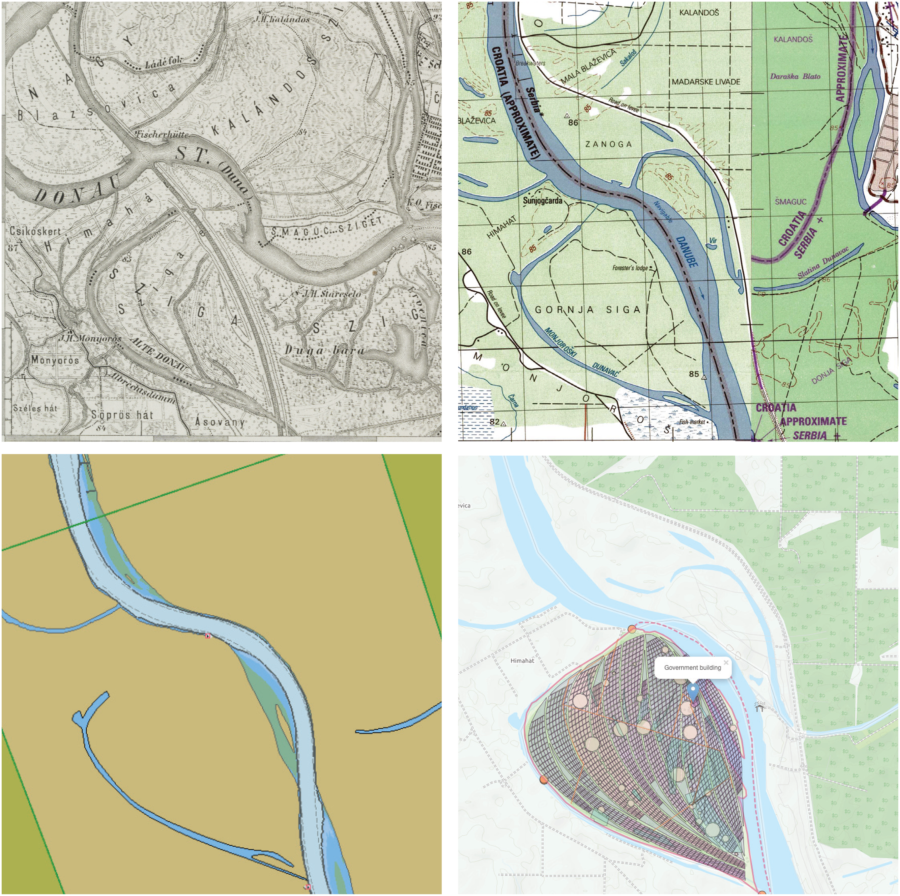
Cartographic representations of Gornja Siga: Top left, 1894 at the time of the Austro-Hungarian Monarchy (K.u.K. Militärgeographisches Institut); top right, composited 1992/1996 1:50,000 series (US Defense Mapping Agency); bottom left, 2018 electronic navigation chart for km 1430-1420 (Danube FIS); bottom right, Liberland Cadastre (e-liberland.org).
Riverlands present a tension in the geopolitical landscape. On the one hand, they often serve as boundaries for political projects that imagine communities separated by ‘natural’ divisions, while also providing the ubiquitous metaphor of connection via bridges, especially in the Balkans (Andrić, 1977; Jezernik, 2004). On the other hand, riverlands are like seas, fluid geographies that signal a world of mobilities, betweeness, instabilities, and becoming (Satizábal and Batterbury, 2018; Peters and Steinberg, 2019; Steinberg, 2013; Steinberg and Peters, 2015). The proclamation of Liberland exploits this liminal uncertainty, and in a segment of riverland cast as a political void this slippery riverland becomes a spatial fix for new projects, a more-than-dry space in which it is possible to think of territory beyond terra (Painter, 2010; Peters and Steinberg, 2019; Peters et al., 2018).
In this way, islands and their environs – aerial, terrestrial, aquatic – may be understood as intensifiers, their particular and distinctive geographies enabling concentrated study of geographical concerns (Stratford, 2018). Islands, especially deserted islands, thus become reconceptualized as a condition of originality that forms the antithesis of homeland thinking and the ontopological, the ‘connection of … present-being to its situation, to the stable and presentable determination of a locality’ (Campbell, 1998: 80; Wylie, 2016). In the imagination of Liberland's founders, this liminal originality is the source of possibility: Every state was originally set up on terra nullius and just as the human mind has no limits, there is no end to how many people could live here: it only depends how high we can build (Nolan, 2015).
Such meandering thoughts forget the contested nature of this damp landscape, which is a shifting fluvial borderscape, an uncertain bank, a demi-island, and a restless river lapping against surficial static ontologies typically associated with land (Steinberg and Peters, 2015; Peters and Steinberg, 2019). Removing ourselves from the (modernization) territorialities of seeing like a state, this rural wetland shows itself to be more-than-dry, more-than-terranean, -subterranean, or -aquatic, while being both sovereign and unsovereign (Scott, 1998; Steinberg and Peters, 2015; Squire and Dodds, 2020).
This ‘hybrid’ human–nonhuman riverine territory lies in a wetland ecosystem containing forests, meadows, ponds, and swamps where birds gather (Whatmore, 2002). Wild geese and ducks, great white egret, white stork, black stork, white-tailed eagle, crows, coots, gulls, terns, kingfishers, European green woodpeckers, and others use this riverscape as a temporary shelter when migrating from the northern cooler regions to the southern warmer areas, and vice versa. This is a ‘more-than-human’ riverine world of fish, including pike, tench, bream, carp, catfish, zander, and perch who inhabit the river, and several mammals who dwell in the river and on marshland, including red deer, roe deer, wild boar, wild cat, pine marten, stone marten, weasel, sable, and otter, while a number of rare plant species take root here including white water lilies, irises, azolla, black sedge, perennial grasses and reeds, Siberian cattail, laxmannov cattail, and vodoljub (Lorimer, 2010). These nonhuman inhabitants reside in a transnational fluvial reserve in the middle Danube, which stretches across borders and beyond an old idea of ‘wilderness' and nature as separate from humanity (Cronon, 1995).
Indeed this contested no-man's [sic] wetland claimed by a small group of libertarians is part of a hybrid human–nonhuman ‘socio-natural hydro-region’ that embraces three protected areas: the Kopački rit nature park in Croatia, the Danube-Drava national park in Hungary, and the Gornje Podunavlje special nature reserve in Serbia (Cosgrove and Petts, 1994; Swyngedouw, 2015). What is more, these parks are also part of one of the largest protected terrestrial and aquatic areas in Europe, a transboundary floodplain and wetland biosphere reserve called Mura-Drava-Danube, which is a five country project – Austria, Slovenia, Croatia, Hungary, Serbia – dubbed ‘the Amazon of Europe’ (Csagoly et al., 2018). An example of ‘hydraulic region-building’ beyond the state, cooperation and joint management between states includes administration of the river ecosystems in a sustainable way, renewal and protection of the natural wetlands and biodiversity, taking care of the drinking water, and encouraging economic development including organic production, tourism, and the protection of cultural heritage (Swyngedouw, 2015).
Gornja Siga and the smaller Siga point bar make up just one of the disputed zones along the Danube, a river which reveals how water becomes part of state-building and the tumultuous processes of modernization, development, and environmental transformation as the Tito regime hydro-electrified Yugoslavia, mirroring ‘Franco's wet dream’ in Spain (Swyngedouw, 2015). Through the Tito years Yugoslavia's waterscapes were transformed via large-scale projects such as building massive hydroelectric power stations and damming rivers like the Danube. Begun in 1964 and completed in 1972 the Iron Gate I Hydroelectric Power Station project was a joint venture between Romania and Yugoslavia to build the largest dam on the Danube and one of the biggest hydro power plants in Europe and was replicated elsewhere as human geographers have explored (Mukerji, 2009; Pritchard, 2011; Usher, 2019b). This ‘regional transformation and industrial revolution’ through hybrid large-scale political–ecological modernization projects reduced in the years after the dissolution of the SFRY (Gregory, 1982). As Swyngedouw (2015) argues, every political project is also an environmental one, and this semi-modernized semi-unmanageable riverscape symbolizes both the huge industrial advances made under socialism and the challenging transformation of the post-socialist era. The hydro-social landscape in the seven successor states has been shaped by rapid deindustrialization and reveals a changing relationship between ‘nature and society’ – the human (coded as white), the inhuman (techne, and the racialized Other), and the nonhuman (the great outdoors) (Haraway, 1990; Latour, 1993; Meillasoux, 2008) – as local communities turn their attention to the ‘concrete ruins’, polluted wetlands, and dilapidated ‘river infrastructure’ that characterize the western Balkans today (Carse, 2014; DeSilvey and Edensor, 2012).
In the geopolitical terms used to describe the political–ecological spaces in the Croatia-Serbia border dispute, the disclaimed territory of Gornja Siga is a ‘pocket’. This hybrid socio-natural boggy pocket was created in the late nineteenth century when Austria-Hungary cut a wider, straighter path for the main channel of the Danube from Bezdan/Batina south to Apatin, and again through the marshes at the Danube's confluence with the Drava River (Klemenčić and Schofield, 2001). The old Baranja cadaster, which Croatia claims, runs with the old meanders, now just scars and oxbow lakes thus crisscrossing the main channel of the Danube, which Serbia claims as its frontier. Control of the pockets was a significant issue raised before the Đjilas Commission in Belgrade in August 1945 after the liberation of the region. Here during the third session of the Anti-Fascist Council for the National Liberation of Yugoslavia (AVNOJ), the administrative boundary between Croatia and Vojvodina was to be set. The decision was made more delicate by wartime expulsions and competing post-war policies to resettle new majorities of Croats and Serbs in the area following the ‘withdrawal’ of Hungarians and Germans (Zečević and Lekić, 1991: 24–27). In the end, the Commission could only recommend a provisional settlement using ethnic and economic criteria and, like other Yugoslav borders, left precision for later, producing roughly 10 adas on the Danube from Hungary to the Drava River.
Fast forward a number of decades and the Arbitration Commission of the Conference on Yugoslavia or the Badinter Commission was set up by the Council of Ministers of the European Economic Community on 27 August 1991 to provide the Conference on Yugoslavia with legal advice as the SFRY was breaking apart. The Commission applied the principle of uti possidetis, recognizing the territorial demarcations at the time of dissolution, handing the land to Croatia. Fast forward another few decades and on the majority of contemporary maps the line follows Croatia's claim of the old Baranja cadastral border, which hands Gornja Siga to Serbia. In imagining that the boundary demarcations among the federal republics were already settled in 1945, the Badinter Commission insisted that those boundaries may not be altered except by agreement freely arrived at and, in addition, except where otherwise agreed, the former boundaries become frontiers protected by international law. The Badinter Commission also established that the new international boundaries, wherever they lie, could not be lawfully changed by force. Despite this proclamation, Gornja Siga and other parts of Eastern Slavonia, including the city of Vukovar, were occupied or under siege from 1991 to 1995 by the remnants of the now Serb-controlled Yugoslav People's Army and Serb paramilitary groups. The siege of Vukovar lasted for three months in late 1991 and destroyed much of the city during the long collapse of the SFRY and became part of the self-proclaimed Republic of Serbian Krajina (1991–1995), which included the land Liberland now claims. The end of the Croatian War of Independence – and the war in Bosnia (1992–1995) – brought an end to the occupation of eastern Croatia via the United Nations Transitional Administration for Eastern Slavonia, Baranja, and Western Sirmium, which provided a United Nations peacekeeping force and transitional administration between 1996 and 1998.
Liberland thus lies in a historically disputed space that has traded hands from Ottoman to Austro-Hungarian empire, to first Yugoslavia, to the quisling occupational state in World War II, to second socialist Yugoslavia, to the self-proclaimed proto-state in the rump Yugoslavia, to the disclaimed land of new republics. It is a space marked by violent changes in population, expulsions and exclusions, seizures and sieges and is reminiscent of the contested Drina valley between Bosnia and Herzegovina and Serbia: both became the focus of violent campaigns to move borders and ethnically cleanse peoples after the collapse of the SFRY, which included a series of massacres from Vukovar to Višegrad and genocide in Srebrenica. Older still are the imagined boundaries of larger civilizational spaces, as the Sava that divides Croatia from Bosnia and Herzegovina was once thought of as the watery edge of the Balkans, the historic border between Christendom and Islam. This left the Balkans open to conquest from imperial powers as it is seen as the near East, and this could reveal why the founders of Liberland and their followers feel they are able to claim land here, as it is on the edge of Mitteleuropa where the land becomes known as the Balkans. The freight of its history struck Evans (1876: 76), who reached the historic military frontier while an insurrection against the ruling Ottomans was underway and these lands would soon become Austro-Hungarian: We are now on the watery boundary-line between Christendom and Islam, and the contrast of the two shores is one of the most striking that can be imagined.
Inventing Liberland: A cyberspatial montage
A right-libertarian political movement has begun a performance of space that is captured in the digital map of Gornja Siga (Branch, 2014; Kitchen and Dodge, 2007). Ground-truthing this performed and represented space by travelling through this Balkan riverscape, reveals something rather different. Gornja Siga is difficult to access by car from Zmajevac, driving along Ulica Maršala Tita (E: Marshal Tito Street) until it becomes Ulica Dunavska (E: Danube Street), before turning south onto Ulica Siga (E: Siga Street) though a flat floodplain kept dry by drainage canals. The final part of the journey must be taken on foot, entering the northern tip of the disputed drop where it clings to the Danube's western bank. A Liberland Settlement Association provides assistance to cross the border but to do so, you must first visit a base camp about 3 km from Bezdan, across the river in Serbia. After arriving at the base camp, you are required to join the Liberland Settlement Association and must volunteer during your stay. Once on the deserted island, a winding single-track trail takes you to a clearing where a yellow house with a roof yet no windows or a door nestles in a clasp of trees (DeSilvey and Edensor, 2012). A yellow and black Liberland flag hangs beneath the gable end and the Liberland motto – ‘to live and let live’ – is scrawled above an arch in black spray paint, a reminder of a fleeting memorial presence constellated here (DeSilvey, 2007). Provenance unknown and abandoned 30 years ago, the ‘hunting hovel’ was later demolished in September 2017, and the first unofficial Liberland dwelling in Gornja Siga is no more (Lewis-Kraus, 2015).
The connection between performance and landscape here differs from Campbell’s (1998: 78) claim that ‘nationalism is the set of social relations with which maps have historically the greatest affinity’. For Liberlanders, in our reading, ontopological present-being is defined as a situation connected to topos by way of a much older cartographic function, that of property, which structures the entire libertarian ideology. Thus, the new state plan of the abandoned area is presented in cadastral form that subdivides the space into neatly aligned parcels, setting aside space for an airship port on the sandy Siga island (Figure 2). Recreation and tourism are emplotted close to where the yellow house was, and a main street runs from the riverside towards Croatian farmland and Libership Town, or Liberpolis, as the capital is called elsewhere. An array of words on the Liberland cadaster float above the small, forested territory, imagining a future division of land and labor: shipping port and heliport, logistics and services, culture, rural village, education and science, agriculture, waste and sewage plant, church and graveyard, sports, health and services, and rural village again.
Drawing upon Foucault’s (1975) studies on the connections between knowledge and power, geographers have revealed that images have a certain geography and images create a certain geography, as can be seen in the power of maps (Cosgrove, 2006; Schwartz and Ryan, 2003). If maps precede territory, then representations of space reveal how ideation makes places (Lefebvre, 1991). The key to working with images for Pink (2001: 76) is an understanding of ‘the social relations and subjective agendas through which they are produced and the discourses through which they are made meaningful’. Moving beyond a ‘representational’ understanding of images common in the ‘new cultural geography’ here we consider the ground of the image, from where Nancy (2005) describes images as groundless, flat but receding spaces: if anything marks the image, it is a deep ambivalence. Yet the representation comes before the landscape here, and as Nancy (2005: 74) writes of digital imagery, We must not even speak any longer of a screen: video is not of the order of the screen, but of penetration … Video means ‘I see’ … Thus, in video, there is absorption in vision, with a tendency toward making absent what is seen … The seer and the viewer come before the visible.
For this reason, the maps and images created of Liberland described here are treated not as a spatial gaze or a representational schema, overarching and constructing the landscape, rather following non-representational theory they are considered as presentations that are ‘in and of the world’ (Dewsbury et al., 2002). Indeed a forest in Gornja Siga is marked ‘the National Forest of Liberland’, a tree the ‘National Tree of Liberland’, and a lodging called Trpovo or Трпово sits uncomfortably beside a monument – a square column with a white cross atop it surrounded by railings. There are named sites on the map including, a government office, a state government office, a Saudi Arabia local government office, a Turkish consulate and an Italian state government office, a corporate office on Siga island, and a property developer. Roads are marked on the map and these imaginary civic buildings are located along them, yet there are no roads or buildings on the ground.
In addition to the representational imaginaries, more-than-representational performances of statehood reveal the affinities and frictions of Liberland's project. Liberlanders have tried to place themselves on the map as a site of regular right-libertarian conferences held in this border region, both in the southern Hungarian city of Baja and in Serbia on the opposite bank of the Danube to Gornja Siga (Koebrich, 2017: 3). One such conference celebrating the second anniversary of Liberland brought together a group of around 50 citizens and supporters who paid a registration fee of up to $400 (USD). The attendees were supposed to take a boat from Budapest to Liberland, but the company cancelled amid claims that they had been pressured to do so by the Hungarian government. A bus instead took the guests – including Liberland's foreign minister Thomas Walls, described as a long-time libertarian activist in the United States, and Dan Mitchell an American economist who has a blog called International Liberty: Restraining Government in America and Around the World – to Baja in Hungary, and following the presentations by a Russian venture capitalist, a cryptocurrency broker, and a utopian architect they took a trip through the historical geographical region from Hungarian Bácska to Serbian Bačka. The plan was to then cross the river by boat to Liberland, yet the Croatian police presence on the western bank prevented this and an imagined citizenship ceremony took place on the eastern bank of the Danube in Serbia instead. Croatia maintains an extraterritorial police deployment which patrols the disputed territory and detains anyone who enters as an expression of possession (Koebrich, 2017: 2).
Theoretically, there are two paths for Liberland to gain international legal recognition, one is the declaratory theory that a state has fulfilled the criteria of the Montevideo Convention (1933) and the second is the constitutive approach that relies solely on recognition of existing states (Rossman, 2016). Balch (2015) called for the United Nations to recognize Liberland on the basis of the ‘homestead principle’ – the libertarian whitewashing of effective occupation – thus countering Croatia's tactic of blocking access to territory it disclaims, a practice the author claims violates a precedent he does not cite. Liberland has another territorial tactic, claiming to be the first virtual platform state, reworking ‘nature state relations' to become a ‘cyber-nation’ or ‘cyborg state’ existing mostly in cyberspace, relieving citizens of the need to live in Gornja Siga and providing, instead, e-residency (Haraway, 1990; Wedgwood, 2000; Whitehead et al., 2007). Indeed Pavel Pospisil, the Honorary Consul of Liberland in Switzerland formed the first political party in Liberland which was modelled after the right-libertarian philosophy of Ayn Rand and stated that it is not necessary for Liberland to have territorial control to form a parliament (Koebrich, 2017: 8). Irrespective of this online place making, the Croatian Ministry of Foreign and European Affairs dismisses Liberland as a virtual quip and states that the differing border claims between Serbia and Croatia do not involve terra nullius and are not subject to occupation by a third party. Somewhat conversely, the Serbian Ministry of Foreign Affairs states that Serbia does not consider Liberland to be an important matter as the new state does not impinge upon the Serbian border, which is delineated by the Danube.
Flattened on-screen, the declaration of Liberland views like a stunt by Vit Jedlička, the nominal first president of Liberland and a Czech politician from the right-libertarian Party of Free Citizens. Liberland's political agenda is right-libertarian and is connected with dark political forces in the United States such as the alt-right, the Tea Party movement, and former Libertarian Party candidate for the U.S. presidency, Ron Paul, who has a Liberland passport and citizenship certificate. Liberland takes its cue from celebrity influencers, ludic put-ons, and enables photo-opportunities for its founders (Benwell et al., 2012). Nonetheless, the projection of Liberland into the mediascape challenges state-centered concepts but in a ‘minor’ way, unlike the more grounded struggles under the signs of globalization, transnationalism, diasporas, state failure, ethno-nationalisms, ideological movements such as Islamic State, and break-away regions (Jellis and Gerlach, 2017). The virtual announcement of a state makes more visible the gap between representational and territorial sovereignty in ways similar to offshoreness, black sites, overseas territories, and the Commonwealth, foregrounding the role and geopolitics of film, radio, television, and the internet in stabilizing new territorial assemblages (Pinkerton, 2019; Pinkerton and Benwell, 2014). Most micronation projects have rather ambiguous claims to territory, including Sealand, built on an artificial platform just outside British territorial waters (Lyon, 2015; Ryan et al., 2006). Yet Vít Jedlička remains loud, committed, and forthright arguing it's nothing but the imagination of people that creates a country (Keating, 2018: 149).
The imperialism of the geographical imagination: Deconstructing Liberland's claim
Reportage and travel narratives about apparent ‘geographical oddities' is a shop-worn imperial genre, which includes atlases of ‘improbable places' (Elborough and Horsfield, 2016) and ‘countries that don't exist’ (Middleton, 2015). Liberland certainly fits the mold of the sort of place that once surprised readers of National Geographic and that now appears in the Atlas Obscura franchise (Sack, 1959; Schulten, 2001). Edging between stolid and sideshow, this genre recounts the strange and uncanny alongside the serious and solemn: displaced peoples are presented on the same plane as remote lighthouses or archaeological excavations. Displaying the idiosyncratic in encyclopedic detail, the visuals are sublime achievements of image and map, yet the effect is to objectify a world for discovery by the reader's knowing, metropolitan eye. In Keating’s (2018) journeys to the ‘edge’ of nationhood, Liberland is featured as just such an oddity to take seriously, placed alongside other ‘outlier states' in an inquiry as to what makes a country. Its exposition alongside Abkhazia, Kurdistan, and Somaliland, a Mohawk reservation, and an island nation threatened by climate change leads to a conclusion that the borders of earth may be emerging from a period of ‘cartographical stasis' and that examples such as these reveal an international order that may not hold (Keating, 2018).
In contrast to the journalistic rendering of so-called geographical oddities, Bartelson (1995) helpfully writes a genealogy of sovereignty, providing a critical analysis and conceptual history of sovereignty, arguing that the concept of sovereignty and its place within political discourse are conditioned by philosophical and historiographical discontinuities. The extensive literature on ‘recognition’ in political science and international relations (see e.g. Visoka, 2018), further help us connect what Wolin (2004) calls ‘the vision’ or imagination of political theory of our contemporary geopolitical disorder, making visible a growing realization that a focus upon territorial sovereignty alone obscures how states act in the world (Abrams, 1988). Jackson (1991) described quasi-states primarily as postcolonial entities that had achieved juridical statehood but came up short on most measures of empirical statehood, in other words, recognized but ineffective. While Caspersen (2011) described unrecognized states as having achieved significant territorial control, internal legitimacy, and basic institutions yet lacking international recognition. Arguments such as these have the significant effect of decentering the idea of unitary sovereign authority leading us to see sovereignty as a bundle of capacities, authorities, and effects that can be incomplete, distributed, and disputed. To this end, Lake (2003) brings focus to ‘practical sovereignty’ as a competition over different aspects of sovereignty by states and private actors, such as customary or traditional leaders. Yet Agnew (2005) argues that de facto sovereignty is, in fact, all that matters analytically and, by implication, that no state has any greater sovereign authority than it can put into effect. What is more, feminist, and postcolonial approaches bring state-building and dispossession closer to the ground through work on the everyday and the performative (Butler and Athanasiou, 2013; Butler, 2015). We are carried along by this stream of scholarship that shifts attention away from analyzing only territorial sovereignty to a focus on acting, rehearsing, improvising, or performing state practices, political agency and political subjectivity when writing of new, post-conflict, fragmented, or unrecognized states (Geldenhuys, 2009; O’Loughlin et al., 2014; Toal and O’Loughlin, 2013) – states in close proximity to the contested Croatian-Serbian fluvial borderscape described in this article (Björkdahl, 2018; Jeffrey, 2013; Visoka, 2018).
In a chapter titled ‘Land of the Free’ Liberland is read as if part of an atlas, the contested borderscape merely an interesting map performing the colonial claim of terra nullius in preparation for new ideological projects (Keating, 2018). The new republic is described as a free-market utopian political experiment in fraternity with populist Beppe Grillo and the Five Star Movement in Italy and Donald Trump's outgoing white nationalist, neofascist administration in the United States (Keating, 2018: 146). The author meets Vit Jedlička in Washington D.C. for the inauguration of Trump amid the swirl of Make America Great Again hats, and again speaks to Jedlička via Skype from the roof of his embassy apartment in Prague. Keating (2018: 144–146) has applied for Liberlandian citizenship and believes the questions that the project raises are valid ones, while also conceding that Liberland is not quite in the same category as places like Somaliland, Abkhazia, or Akwesasne that people have fought and died for. Yet he wonders why a group of libertarians should not be allowed to found a new state in Gornja Siga if they can be bothered to put in the time and effort (Keating, 2018: 145). This argument echoes the late-colonial idea of ‘effective occupation’ that emerged from the Berlin Conference (1884–1885): making territory useful creates property unencumbered by the past and ready for new state projects (Fitzmaurice, 2007).
There is a territorial moment unfolding on Gornja Siga akin to disaster capitalism, an ideological project constructed on the failure of territorial sovereignty (Klein, 2007). A libertarian state predicated on private property reveals its parallel with the colonial: the fantasy land of emptiness and availability was achieved through violent dispossession – war, dissolution of the state, corrupt expropriation of land. Liberland shows the problem of declaring sovereignty writ large, that is, the imagination of an unpopulated space always precedes the dispossession of those living there. It is unlikely that Gornja Siga and Siga island are wholly unclaimed, as the idea of unclaimed land would run into restitution claims on the one hand, and social ownership questions on the other, neither of which have been justly resolved in the post-socialist Yugoslav context. Thus, Liberland takes advantage of other claimants’ inability to assert their rights in the borderland setting. Even if there are no claimants, it preys upon depopulation and it is not the first time that rightist projects have claimed putatively ungoverned spaces or remote, ‘uninhabited wilderness' (Cronon, 1995). Here we can think of Marx (1912) on the intensity of primitive accumulation during the Highland Clearances and settler colonial dispossession of Indigenous land.
Liberland's founders selected Gornja Siga not for its ecology but its ‘emptiness'. After all, they originally considered a small plot on the Slovenian-Croatian border and the disclaimed desert land of Bir Tawil as possible sites to house their new state. The latter is a roughly 800 square mile stretch of land was made terra nullius by a discrepancy arising from the straight political boundary drawn in 1899 and the irregular administrative boundary established in 1902. Egypt asserts the political boundary, Sudan the administrative boundary, with the result that the Hala’ib Triangle is claimed by both and Bir Tawil by neither. In Unruly Places, Bonnett (2014) described Bir Tawil as the only place on Earth that was habitable but was not claimed by any recognized government. It is incredible to think that anywhere could be so ill thought of that no one wants it, writes Bonnett (2014: 73), yet its story is of universal importance according to the geographer. Terra nullius and Bir Tawil for Bonnett (2014: 73) amount to an oddity in the regular functioning of space on the world map – perhaps even the condition of originality.
Here we argue that terra nullius is a colonial invention, a ‘hyperobject’ – an object that has a vitality to it but which you cannot touch, like race, or class, or climate change – and exists beyond a cartographic exception (Agamben, 2005; Connor, 2005; Morton, 2013). The history of terra nullius is a disturbing story of how no-man's [sic] land became the province of the white man (Lindqvist, 2007). Terra nullius operates as an inhuman geography, a legal fiction in international law enabling expulsion, ethnic cleansing, dispossession, and displacement and more recently, in Zionist narratives, it is mobilized to justify Palestinian home demolition and Israeli settlement construction (Joronen, 2017; Said, 1979). The myth of emptiness appears again in the proverb, ‘Land without a people for the people without a land’ (Said, 1979: 9). Terra nullius as such acts as a colonial motif which has been an essential part of Zionist narratives of an ‘empty land’ (Yiftachel, 2002: 224–225), a landscape subject previously to ‘two millennia of neglect’ before settlers arrived and created ‘agricultural and botanic miracles' in the barren wastes (Long, 2009: 65). The erasure of the Palestinian, writes the former deputy mayor of Jerusalem, made possible a ‘virgin landscape’ shown on maps as ‘white patches' (Benvenisti, 2000: 52–65). In Butler’s (2010) terms: the sacrifice of some lives is more grievable than others (Sontag, 2003).
Terra nullius, as we show here, is a colonial spatial imaginary. Yet uncertain spaces such as Gornja Siga and Bir Tawil continue to fascinate geographers, becoming a way in which to enter questions of post-statist geographies, conceptualizations of sovereignty and the territorial state (Ince and Barrera de la Torre, 2016). Zones such as no-man's [sic] land reveal how indistinction operates in the lifeworld of borderlands and human geographers have argued that such spaces are more than an exceptional topological space; they are also spaces of political possibility (Agamben, 2005; Berdahl, 1999). To ‘reinvigorate the critical power of no-man's [sic] land as an analytical category’, Leshem and Pinkerton (2016: 41) have called attention to ‘the social life and political possibility harbored in spaces designated as the no-man's [sic] lands’. This work takes no-man's [sic] land a step beyond symbolic exception to where it becomes the opening of a ‘geopolitical alterity’, or an ‘anomalous geopolitical space’ (Jeffrey et al., 2012, 2015). ‘Topologies of power’ are ‘re-inhabiting’ this space of political possibility in Gornja Siga in the new imperial present (Allen, 2016). Here a new micronation called Liberland relies upon imperial strategies that violently conjure a blank space, before extending the right of property (Gregory, 2004; Harvey, 2003).
After montage: The imperial present
Fictional lands appear most commonly as settings or subjects of myth, literature, film, or video games yet they are often variations on the same story and draw their oddities from imperialist imaginations all the way back to Swift’s (1726) Lilliput and Blefuscu. The invention of Ruritania and the imperialism of the imagination are projected onto the Balkans, where an exploitation of Balkan history and geography in Western cultural representations and performances has created a region that is the ‘Wild East’ of Europe and Oriental at the same time and yet tantalizingly ambiguous: simultaneously attracting and repelling outsiders (Goldsworthy, 1998). Even if we can only occupy them as imagined geographies, self-proclaimed micronations are an exercise in identification and ‘difference’, of claims to rights and wish-images of ideological ‘purity’ (Deleuze, 1994; Nancy 2000). These stories are found in other unofficial countries, such as Molossia, Aerica, Atlantium, Kugelmugel, Sealand, Seborga, Talossa, Tonava, Minerva, Christiania, the Hutt River Province, the Principality of Wy, the Kingdom of Elleore, and the Empire of Austenasia (Ryan et al., 2006). Erupting out of a ‘closure of the map’ which was the historical result of geographical imperialism, micronations might be post-colonies (Jazeel, 2019). Kugelmugel was an antifascist resistance movement and is considered a ‘fictional state’ while Seborga claims a long history dating back to Benedictine Monks and is considered a ‘tourist destination’ due to its ‘non-nation’ status (Serzhanova, 2014; Timothy, 2003). All are performative fictions, narrative spaces, and spatial narratives unrecognized by other ‘legitimate’ nations (McDougall, 2013; Ryan et al., 2016). Keighren (2005) charts the ‘geosophy’ of American geographer Wright (1947) – the study of the world as people conceive of and imagine it – tracing imaginary worlds from a childhood fantasyland Cravay to the mountainous terrae incognitae of New England, which the geographer explored as a youth. Here we chart a darker geosophy, a far more disturbing geographical imagination, addressing the active role of geography in shaping war and peace and as a tool of imperialism (Schulten, 2001).
What is more, geographic representation plays a decisive role in constructing this popular geographical imagination by building ‘imaginal’ worlds, and human geographers have explored the ‘geopolitical implications and effects of pictures and maps' (Bottici, 2014; Cosgrove, 2006, 2008; Daniels, 2011: 183). Echoing this well-established literature on representations of the Balkans in geography and literary studies – such as Inventing Ruritania (Goldsworthy, 1998) and Imagining the Balkans (Todorova, 1997) – Mazower (2002) writes that representations of the Balkans loaded the Balkans with negative connotations: inharmonious conditions, small antagonistic states, and hostile nationalities, all of which conspired to form the intractable Balkan or Eastern question. Writing of the Balkans as Europe's ghost, Žižek (2000: 1–2) argues the region is always somewhere a little further to the southeast, and the Balkans are a photographic negative of a multicultural, post-political, post-ideological Europe. A ‘postmodern racism’ exists, Žižek (2000: 1–2) claims, where an imaginary Balkans is constructed as the intolerant Other; a region of ‘ancient ethnic hatreds' (Goldsworthy, 1998). A ‘view-from-above’ thus maps a liminal borderscape, a zone of increasingly Orientalist indistinction in the ‘European geographical imagination’ where new political projects like Liberland can take root in unresolved, unsettled spaces (Heffernan, 2007; Williams, 2013). Such projects reflect Said’s (2003) notion of ‘imaginative geography’ as an imperial projection. Daniels (2011: 183) refers to this as the ‘darker side’ of the geographical imagination; the issue of ‘who possesses the powers of the imagination’ and ‘where it is materially deployed’ (Daniels, 2011: 183). The geographical imagination is a view from somewhere not nowhere, defining places and peoples; a one-dimensional, imperial, racist, European, Western, white gaze (Morrison, 1992).
Using a fragmentary literary technique, a singular view is de-centered as we montage here the fundamental importance of the geographical imagination to imperial visions in the present (Bassin, 1999). Yet geography and imperialism have been intrinsically linked for centuries, and the modern discipline of geography directly stemmed from imperialism (Painter and Jeffrey, 2009: 176). In a Capitalocene (Moore, 2015), Chthulthucene (Haraway, 2016), Plantationocene (Tsing, 2005), or ‘a billion black Anthropocenes' (Yusoff, 2019), ‘new geography’ was promoted to serve ‘the interests of imperialism in its various aspects including territorial acquisition, economic exploitation, militarism and the practice of class and race domination’ (Hudson, 1977: 12). ‘Others are already inscripted in the foundation formulation of the universal as a space of privileged subjectification … caught between the hardening of geopolitical borders and the material de-stratification of territory’ (Yusoff, 2019: 50–62). Geography, as we explored here in a Balkan riverscape, is a tool of imperialism, from cartography and settlement planning, to environmental determinism; the belief that the environment shapes character and culture (Gilmartin, 2009: 116).
Liberland reveals a disregard for the ‘regional cultural landscape’ of the western Balkans; a post-conflict, post-socialist, post-Yugoslav context where seven new states have been formed (Matless, 2014). Evaluating this ‘outlier state’ named Liberland, we are put in mind of student exercises in city planning, theme parks, model villages, or the model United Nations (Keating, 2018). State-building for ‘micropatria’ such as Liberland often leads their creators to fashion statist iconography and mimic the legitimizing practices that recognized and unrecognized states undertake (McConnell et al., 2012). It is not the oddity and peculiarity of ‘outlier states' like Liberland that interests us in this article, as the inside/outside distinctions disappear in the logic of the construction of geopolitical space (Agamben, 2005; Keating, 2018). We montage Liberland because Liberland represents a right-libertarian ideology in and of the world and we have a ‘responsibility’ as geographers to counter this land grab originating from the classic imperial geographical imagination (Massey, 2004).
We undertake a micro-study of a small space in this article following others who have explored ‘micropolitics' (Jellis and Gerlach, 2017), and the ‘politics of microspection’ (Cronin, 2012). Yet we write a big relational story, tracing outwards the macro geographies and wide-reaching geopolitics of seemingly contained public spaces, as human geographers have in hotels, cafes, and streets (Cresswell, 2019; Fregonese and Ramadan, 2015; Jeffrey et al., 2018). We perform a ‘moderate relationalism’ intertwining flow-like takes on space, and more fixed takes on space in a contested political–ecological riverine borderspace (Jones, 2009). We reanimate ‘regional cultural landscape’ and argue for a radically new ‘new cultural geography’ in material–immaterial, representational–nonrepresentational, and human–nonhuman cyberspaces, as increasingly human engagements with space occur through digital encounters, processes, and technologies (Cosgrove, 1983; Cosgrove and Jackson, 1987; Matless, 2014). We extend work in historical geography on river islands (De Vorsey, 1980), work in cultural and political geography on islands, rivers, and oceans (Peters et al., 2018), work in regional and political geography on borders, territory, and de facto states (O’Loughlin et al., 2014; Paasi, 1999; Usher, 2019a), work in political ecology in infrastructural riverine spaces (Swyngedouw, 2015), and work in social and political geography on no man's [sic] land (Leshem and Pinkerton, 2016).
In the absence of an ‘intimate geopolitics' of bodies residing in this small island space who embody this little territory as a lived experience, we trace relational stories from the region to resituate this contested space in the human and more-than-human geopolitical landscape of a post-conflict, post-socialist, post-Yugoslav, western Balkans (Smith, 2012, 2020). Extending relations beyond the proximate, we trace lived and embodied geopolitical relations to represent this right-libertarian colonization across various state boundaries to elsewhere in Europe and on to the United States, to reveal their individual and collective political agendas and affiliations (Ahmed, 2000). Balkanism provides the grounds for colonial violence, and as we show here by thinking space, nature, and politics relationally (Catz, 1995; Ekers et al., 2013), it is possible to reorient, subvert, and sink a Balkanist imaginary, gaze, and claim. Liberland is a discomforting imperial act of planting a flag in the ground and in the imagination; an imaginative, textual, cyber colonization described by Todorova (1997) in Imagining the Balkans and Goldsworthy (1998: 211) in Inventing Ruritania as the way in which an area can be exploited as an object of the dominant culture's need for a dialogue with itself.
Footnotes
Acknowledgments
The authors would like to thank the anonymous reviewers for their insightful comments and suggestions, and colleagues at Tampere University, Finland, who read an earlier version of this article and provided feedback.
Declaration of conflicting interests
The authors declared no potential conflicts of interest with respect to the research, authorship, and/or publication of this article.
Funding
The authors disclosed receipt of the following financial support for the research, authorship, and/or publication of this article: This work was supported by the British Academy (grant number SRG1920\101002).