
Abstract
Extensive, unprotected tracts of tropical forests remain in community territories of the Calakmul region, in the Yucatan Peninsula of Mexico. These forest tracts face deforestation mainly due to agricultural development. Based on the graphic theory and using the CONEFOR SENSINODE 2.2 program, we analyzed the landscape connectivity between the forests of two communities and Calakmul Biosphere Reserve. Derived from vegetation cover and land use classification, the landscape was characterized considering Baird’s tapir habitat preferences. The indices used showed a loss of connectivity between community territories and Calakmul Biosphere Reserve, making it difficult for tapirs to move outside the continuous forests. We detected a few important nodes for landscape connectivity and a reduced number of connections allowing potential tapir dispersal in each study site. Despite the evident trends of forest fragmentation across the Calakmul region, our results suggest that the landscapes of our study sites are not optimal, but still usable for tapirs, which are able to move throughout habitat mosaics of forests and agricultural areas. We recommend that farming practices should be encouraged over mechanized agriculture to mitigate deforestation and tapir habitat loss in the study area.
Introduction
Currently, many large mammal species are threatened and persist in shrinking populations (Ripple et al., 2014). Their low reproductive rates and occurrence in isolated natural protected areas increase their susceptibility to stochastic, demographic, environmental, and genetic processes eventually resulting in high extinction rates (Roelke, Martenson, & O’Brien, 1993; Shaffer, 1981). In addition, the loss of landscape elements due to forest fragmentation continues to reduce usable habitat for such species and the possibility of maintaining connectivity with adjacent forests (Pascual-Hortal & Saura, 2006; Saura & Pascual-Hortal, 2007).
Baird’s tapir (Tapirus bairdii) populations have been drastically reduced due to high rates of habitat fragmentation and loss throughout its distribution range in southeastern Mexico and Central America, constraining its populations to protected areas and a few extensive community territories (Matola, Cuarón, & Rubio-Torgler, 1997; Naranjo 2018). Tapirs are important seed dispersers and seed predators (Camargo-Sanabria & Mendoza, 2016; Naranjo, 1995; O’Farrill, Calmé, & Gonzalez, 2006; Olmos, 1997). They seem to prefer extensive tropical and montane mature forests and in some cases secondary forests with high availability of food and water (Naranjo, 2009; Pérez-Cortéz, Enríquez, Sima-Panti, Reyna-Hurtado, & Naranjo, 2012). They are very sensitive to hunting due to their low natural population densities and their limited reproductive rates (Cruz et al., 2009). Such life features in addition to habitat loss due to the expansion of farming, livestock grazing, and infrastructure greatly reduces the probability of population survival (García, Leonardo, Castillo, García, & Gómez, 2009; Lira-Torres, Naranjo, Güiris, & Cruz, 2004; Naranjo & Bodmer, 2007; Schank et al., 2015).
Tapirs currently occur primarily, but not exclusively, in extensive tropical and montane forests in the Mexican states of Campeche, Chiapas, Oaxaca, Quintana Roo, and Veracruz (Naranjo, 2009, 2018). The Calakmul region in the state of Campeche constitutes the largest area sheltering viable tapir populations in Mexico (Reyna, Sanvicente, Pérez, Carrillo, & Calmé, 2016). However, due to the significant transformation of native forests into farming and grazing areas with intense human activity, there is an increasing risk of isolation for tapir populations in communities around the Calakmul Biosphere Reserve (CBR). A recent study in this area showed that tapirs frequently used agricultural landscapes with semipermanent crops within a matrix of mature and secondary forests (Carrillo, Naranjo, Reyna-Hurtado, Cortina-Villar, & Mendoza, in review), which suggests that this species is probably more resilient to habitat disturbance than previously thought. Therefore, it is important to assess the variables of fragmented landscapes facilitating tapir dispersal between the CBR continuous forests and surrounding community forest patches.
Our goals were to (a) characterize the landscape structure in the corridors between CBR and two adjacent communities and (b) evaluate the degree of connectivity between forest fragments from a Baird’s tapir perspective of habitat use. Considering the wide variations previously observed in land use and management across the communities of our study area, we expected to find more heterogeneous landscapes in their territories than in CBR. In addition, large tropical mammals (e.g., tapirs) are usually vulnerable to forest fragmentation (Davies, Margules, & Lawrence, 2000). Therefore, we predicted that tapirs would find the landscape of our study area risky for dispersal from CBR toward community territories.
Materials and Methods
Study Area
This investigation was carried out in the area between CBR and two adjacent communities: Nuevo Becal (NB), and 20 de Noviembre (20 N; Figure 1). The Global Forest Change model developed by Hansen et al. (2013) showed that this area was under a fragmentation process that persists today, mainly due to the expansion of agricultural areas (Figure 2; Ellis, Hernández-Gómez, & Romero-Montero, 2017). The study area is mostly covered by tropical subdeciduous and deciduous forests with clay soils and poor drainage (Instituto Nacional de Ecología, 1999). Mean annual temperature is 27°C with a rainy season between June and October (Arriaga, Espinoza, Aguilar, & Martínez, 2000; Garcia-Gil, 2003). The region has a predominantly flat topography with hills up to 385 m above sea level (Guerra, 2010).

Polygons adjacent to CBR, Ejidos NB and 20 de Noviembre, Campeche, Mexico. CBR = Calakmul Biosphere Reserve; NB = Nuevo Becal.
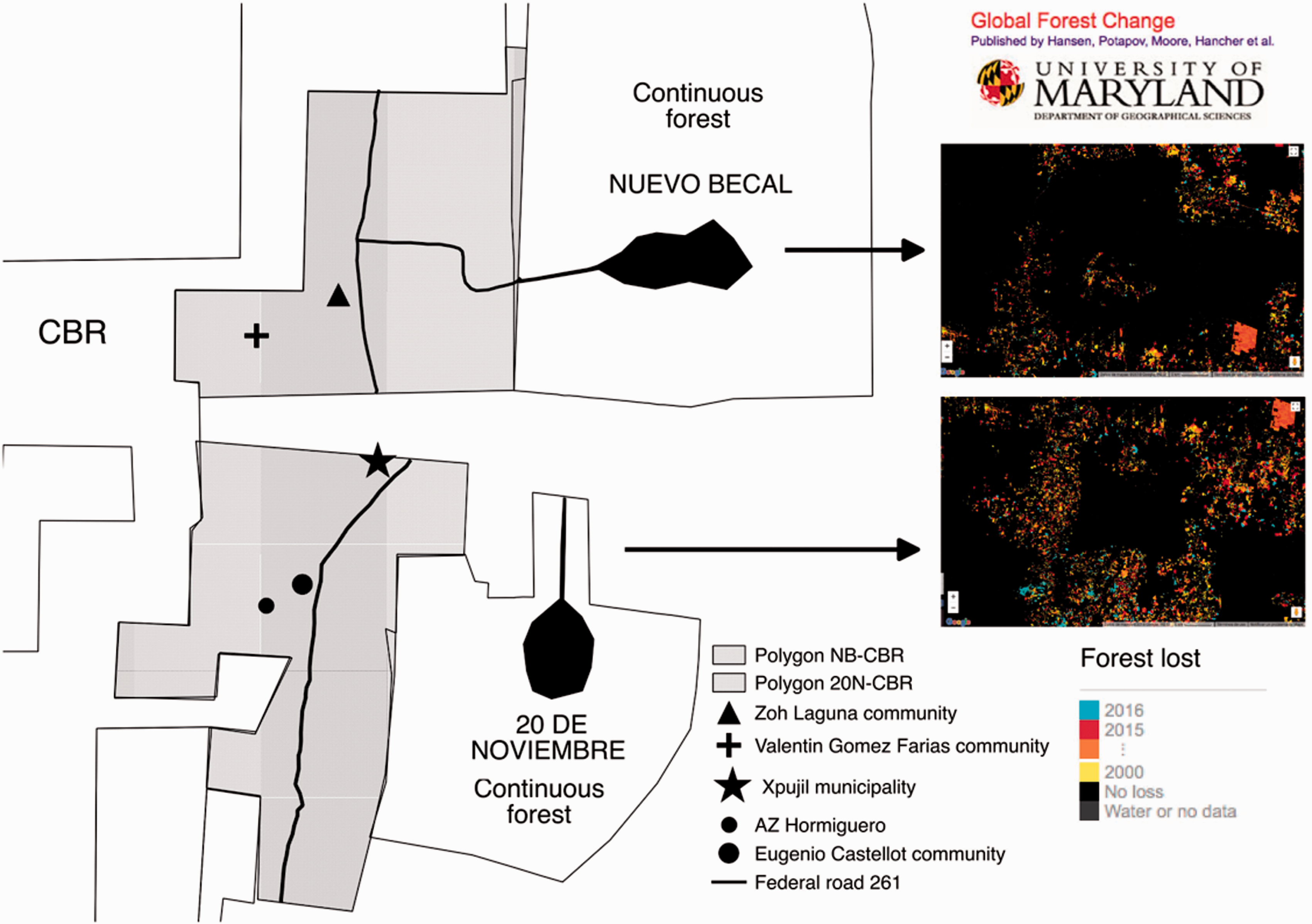
Location of the study area and “Global Forest Change” model by Hansen et al. (2013), showing forest loss between 2000 and 2016 in the middle zone between Ejidos Nuevo Becal, 20 de Noviembre, and CBR. CBR = Calakmul Biosphere Reserve.
In NB and 20 N, more than 80% of farmers cultivate milpas, traditional agroecosystems whose main components are corn (Zea mays), beans (Phaseolus vulgaris), and squash (Cucurbita pepo). Slash and burn farming is usually practiced in 1 to 3 ha plots. Due to the soil’s low productivity, each plot is used only for 2 or 3 years before being abandoned for longer periods. Shortly after abandonment of plots, new areas are opened to cultivation by clearing mature secondary vegetation (Arreola & Villalobos, 2008).
Veinte de Noviembre (27,320 ha) has 83.2% of its territory designated as a permanent forest area (Villaseñor, 2014). Most of this forested area has been used for timber harvest (Agencia Alemana de Cooperación/Comisión Nacional de Áreas Naturales Protegidas, 2009). Conservation and management of this forest is of global importance because it is adjacent to CBR and constitutes a corridor between this protected area and Sian Ka’an Biosphere Reserve in the state of Quintana Roo (Villaseñor, 2014). The community founders are Mayans and a total of 418 people live in the village (Instituto Nacional de Estadística, Geografía e Informática, 2010). Its food autonomy depends on Mayan milpa, and their earnings come from the use of forest resources, beekeeping, carpentry, handicrafts, and labor (Agencia Alemana de Cooperación/Comisión Nacional de Áreas Naturales Protegidas, 2009).
NB has 53,000 ha of which 25,000 ha are locally protected as a forest preserve. Villagers (N=420) have the largest plots of land in the region (305 ha each), which are located in the multiple-use area. They originally migrated from the states of Veracruz, Tabasco, Chiapas, and northern Campeche and live from diverse activities including the sale of wood, charcoal, jalapeño peppers, honey, and sport hunting services (Comisión Nacional Forestal, 2009). The population of NB decreased from 1990 to 2005 due to migration to nearby cities, and this trend is expected to continue for the next 20 years (Comisión Nacional Forestal, 2009).
Vegetation Cover Classification and Land Use
To obtain an initial assessment of the classes and spatial distribution of vegetation types in the study area, a map with the normalized difference vegetation index (NDVI) was elaborated in the Geographic Information System Qgis (GRASS Development Team, 2017). To achieve this, ortho-rectified SPOT 6 images (spatial resolution 1.5 m in the panchromatic band and 6 m in the multispectral bands) were used. These were the highest resolution images available for our study, which were taken in 2015 by the antenna of the Mexico Reception Station of the constellation SPOT (ERMEX) and provided by El Colegio de la Frontera Sur.
Subsequently, a maximum likelihood supervised classification of vegetation types and land use was carried out using GRASS GIS software (GRASS Development Team, 2017). The cover types considered were those in the Management Program of the CBR (Instituto Nacional de Ecología, 1999): (a) Medium forest. Dominant trees are up to 25 m high. From 25% to 50% of its elements lose leaves during the dry season. It is the most altered type of vegetation and the one with the widest distribution in the study area. (b) Low forest. Tree layer up to 15 m high, similar composition with the medium forest, but apparently due to the effect of wind and poor soil development, the trees do not reach full development. (c) Low flooded forest. It spreads in places of deficient drainage; its clay soils (ak’alche) are deep, with trees under 10 m in height. It represents a very important area due to its higher water availability and its corresponding biodiversity. (d) Secondary vegetation. Second growth forest patches of different ages (1–20 years). (e) Farming zone. Semipermanent agriculture (SA) areas surrounded by forest or mature secondary vegetation. The most important cultivated species are corn (Zea mays), beans (Phaseolus spp), squash (tudioasp), chili (Capsicum spp), sweet potatoes (Ipomoea batatas), and citrus fruits (Citrus spp), as well as semicultivated species such as zapote (Manilkara zapota), chaya (Cnidoscolus chayamansa), and nance (Byrsonima crassifolia).
For greater confidence in the selection criteria of vegetation types, the classification by maximum likelihood and the data obtained with the NDVI were compared. To verify classification accuracy, coordinates were taken in the field that corresponded to points of main vegetation types and agricultural zones, by simple random sampling, in routes within the conservation area and in the agricultural areas of each village. We obtained at least 20 samples per class (Jensen, 2004), since five classes were contemplated, which were applied as training sites to perform the supervised classification. The accuracy of the cover map vegetation was evaluated using an error matrix (Jensen, 2004). To measure the agreement between both data sets, Cohen’s Kappa Coefficient (Cohen, 1960) was applied with values ranging from 0 = very low concordance, to 1 = maximum concordance. The index was obtained using the statistical software SPSS (IBM®).
Landscape Connectivity
Derived of vegetation cover and land use classification, medium and low forest patches were selected in accordance with known tapir habitat preferences (Carbajal-Borges, Godínez-Gómez, & Mendoza, 2014; Naranjo, 2009; Naranjo, Amador-Alcalá, Falconi-Briones, & Reyna-Hurtado, 2015; Pérez-Cortéz, Enríquez, Sima-Panti, Reyna-Hurtado, & Naranjo, 2012). Based on published data on Baird’s tapir home range size and movements (Carbajal-Borges et al., 2014; Naranjo, 2009; Reyna-Hurtado et al., 2016), we selected forest patches greater than 1 km2. A database containing habitat patches with a node identification number (ID, node = habitat patch) was developed. In addition, another database was developed to include the ID of node I, ID of Node j, and the Euclidean distance value to the centers of Nodes i and j. These data were weighted with a distance matrix, whose elements represented the distances between the points taken. The distance matrix was formed by the ID elements against the same ID elements to obtain the shortest distances between points.
The CONEFOR SENSINODE 2.2 program (CS22, Saura & Torné, 2009) was used to model landscape connectivity by quantifying the importance of habitat patches through indices of habitat availability. CONEFOR addresses connectivity from a functional perspective considering the spatial disposition of the habitat (structural connectivity), dispersal distances, and the behavioral response of tapirs to the landscape’s physical structure (functional connectivity; Theobald, 2006; Tischendorf & Fahrig, 2000). A threshold distance of 5 km was specified in the analyses, which corresponds to the dispersal range of tapirs in Calakmul (Reyna-Hurtado et al., 2016). The following connectivity indices were developed:
Connectivity binary model
This model considered that each of the nodes was connected or not. A connection between a pair of nodes involved the ability of an organism to disperse directly between them. A connection between two nodes was assigned by comparing the distances between them and the specified dispersal distance threshold for the organisms under study. If the internode distance was shorter at the dispersal threshold distance, a connection was assigned to that pair of nodes (Saura & Pascual-Hortal, 2007). The binary index used was the integral connectivity index (IIC) ranging from 0 to 1:

Probabilistic connectivity model
This model characterizes the connections through a direct dispersal probability between each two nodes as an estimate of the force, frequency, or viability of that direct movement by the organisms analyzed. The index used was the probabilistic connectivity index (PC) that varies from 0 to 1:

CONEFOR provides a general value of the computed indices, as well as each region components. A component is a set of nodes in which there are paths between each pair of nodes. There is no functional relationship between nodes belonging to different components. An isolated fragment may function as a component on its own. A better connected landscape will have fewer components (Saura & Pascual-Hortal, 2007). The most important nodes were chosen for each polygon according to CS22. Each node was characterized by measuring its shape, composition, and position to assess their value as tapir habitat in the Calakmul region (Carrillo, Weissenberger, & Reyna-Hurtado, 2015; Pérez-Cortéz et al., 2012; Reyna-Hurtado & Tanner, 2007; Sandoval-Serés, Reyna-Hurtado, Briceño-Méndez, & De la Cerda-Vega, 2016). The size of forest patches, milpas, and water bodies were measured, as well as their distances to federal highway 186 and adjacent villages (NB or 20 N). These variables were assessed by using the vector data set of topographic information (scale 1:50,000, series III; Instituto Nacional de Estadística, Geografía e Informática, 2017), and Google Earth 2018©. To know how the connectivity of the landscape would be affected by a node disappearance, the model was computed with the same characteristics but sequentially removing each node by extracting its ID and all its information in each new run.
A set of tapir habitat and connectivity maps were created by using the data obtained in the spatial analyses (number of nodes per study area, topographic position of each node in the landscape, habitat composition, and quality), and the indices generated (IC = Integral Connectivity, and PC = Probabilistic Connectivity). The most likely connections between habitat patches were selected by considering their cover, distance, and potential to function as corridors for tapirs. In the final map, habitat fragments with conservation (Priorities 1, 2, and 3) were identified.
Results
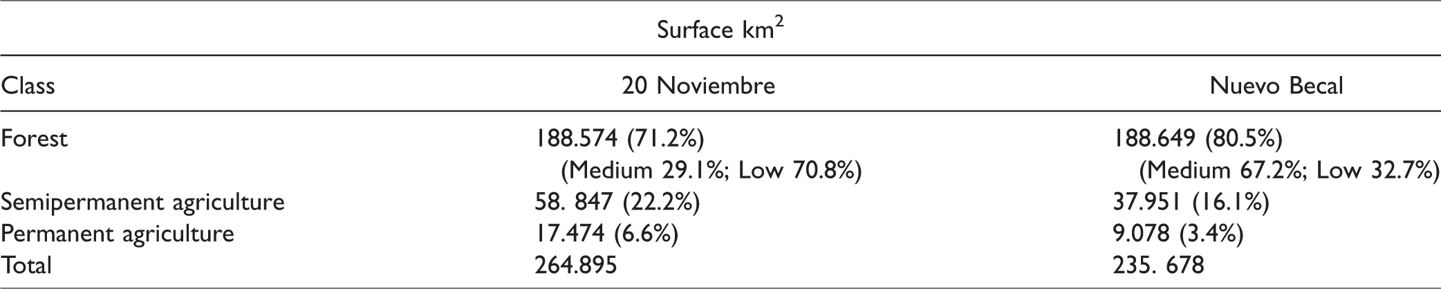
The NDVI allowed identifying five main cover types: medium forest, low forest, secondary vegetation, SA, and permanent agriculture (hereinafter PA). From the maximum likelihood classification, the landscape elements were grouped into four final classes: medium forest, low forest and low flooded forest, SA and secondary vegetation, and PA and town (Figures 3 and 4). The average value of estimated agreement accuracy between the classification and the reference data was 81.4%. Likewise, the value of the Kappa index showed that there was agreement between the classification and the reference data (Table 1). The total area that made up the territory under study Calakmul-20 de Noviembre (hereinafter C-20 N) was 264.89 km2, of which 71.2% corresponded to medium and low forest. The total area of the Calakmul-NB territory (hereinafter C-NB) was 235.68 km2, of which 80.5% corresponded to forest cover (Table 2).

Vegetation cover and land use in the middle zone between Ejido 20 de Noviembre and CBR, Campeche, Mexico, and the probability of direct connection between the most important nodes. CBR = Calakmul Biosphere Reserve.

Vegetation cover and land use in the middle zone between Ejido NB and CBR, Campeche, Mexico, and the probability of direct connection between the most important nodes. CBR = Calakmul Biosphere Reserve; NB = Nuevo Becal.
Error Matrix of the Forest Cover Classification Map and Land Use Derived From SPOT 6 Images From the Calakmul region, Campeche, Mexico.
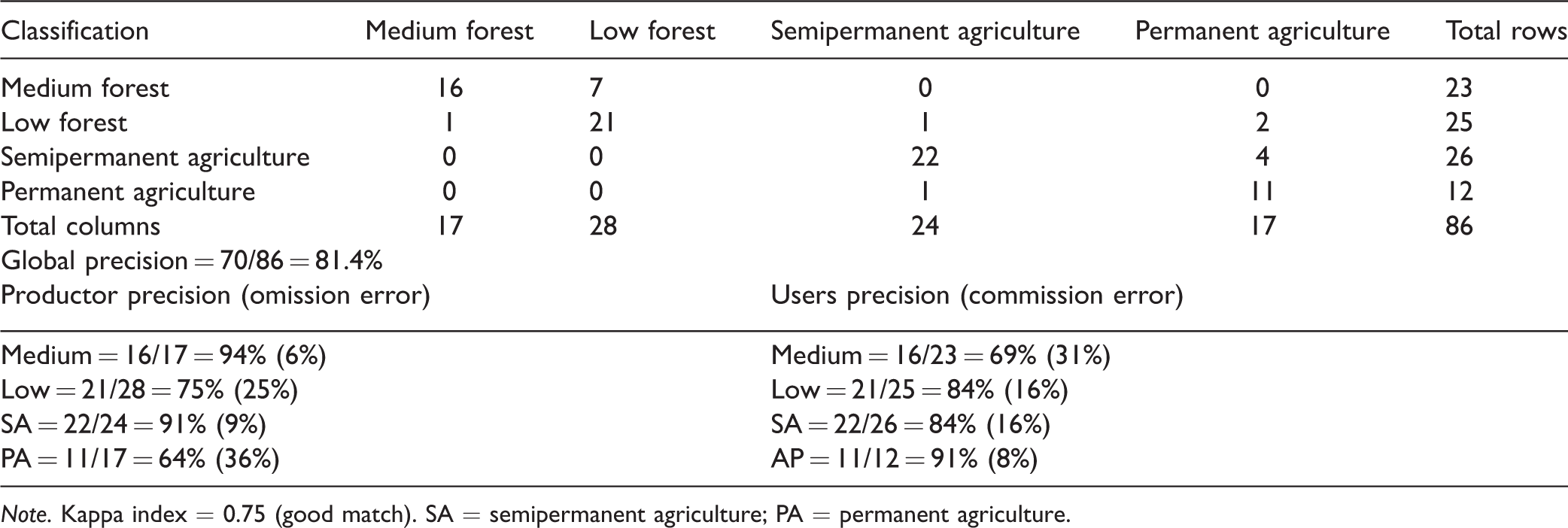
Note. Kappa index = 0.75 (good match). SA = semipermanent agriculture; PA = permanent agriculture.
Covered Area (km2) for Each Class of Forest Cover and Land Use in the Calakmul Region, Campeche, Mexico.
Landscape Connectivity
The IC was lower for the C-20 N area (0.09), which presented two components in its configuration, indicating a less connected landscape and made up of two large blocks of unconnected nodes. Zone C-NB had a higher IC (0.15), and only presented one component in its configuration. In total, 15 and 18 nodes composed by forests and areas greater than 1 km2 were obtained for 20 N and NB, respectively. CONEFOR allowed to estimate the proportional area occupied by each node in the landscape (dI) and its indices (dIC and dPC). The three most important nodes were chosen in each study area: 20 N, Nodes 15, 9, and 1; NB, Nodes 4, 6, and 10 (Figures 3 and 4). The nodes with the highest contribution to landscape connectivity were Node 9 in 20 N and Node 4 in NB (Tables 3 and 4). Node 9 in 20 N was the one with the highest percentage of agricultural surface (30.6%). Contrastingly, Node 4 in NB only maintained 5.5% of the agricultural surface in its interior.
Attributes of Nodes With Greater Value for Landscape Connectivity in the Middle Zone of Ejido 20 de Noviembre (20 N) and Calakmul Biosphere Reserve, Campeche, Mexico.

Note. IC = integral connectivity index; PC = probabilistic connectivity index.
Attributes of Nodes With Greater Value for Landscape Connectivity in the Middle Zone of Ejido Nuevo Becal (NB) and Calakmul Biosphere Reserve, Campeche, Mexico.

Note. IC = integral connectivity index; PC = probabilistic connectivity index.
For 20 N, 105 connections between nodes were identified; 17 were positive, corresponding to the threshold value distance traveled by tapirs. Of these, four had a 50% probability of direct dispersal, and five connections had a 100% probability of direct dispersal (Figure 5). For NB, 32 positive connections out of 153 possible combinations were obtained. Of the 32 connections, six had a direct dispersal probability of 50%, and four had a dispersal probability of 100% (Figure 6).
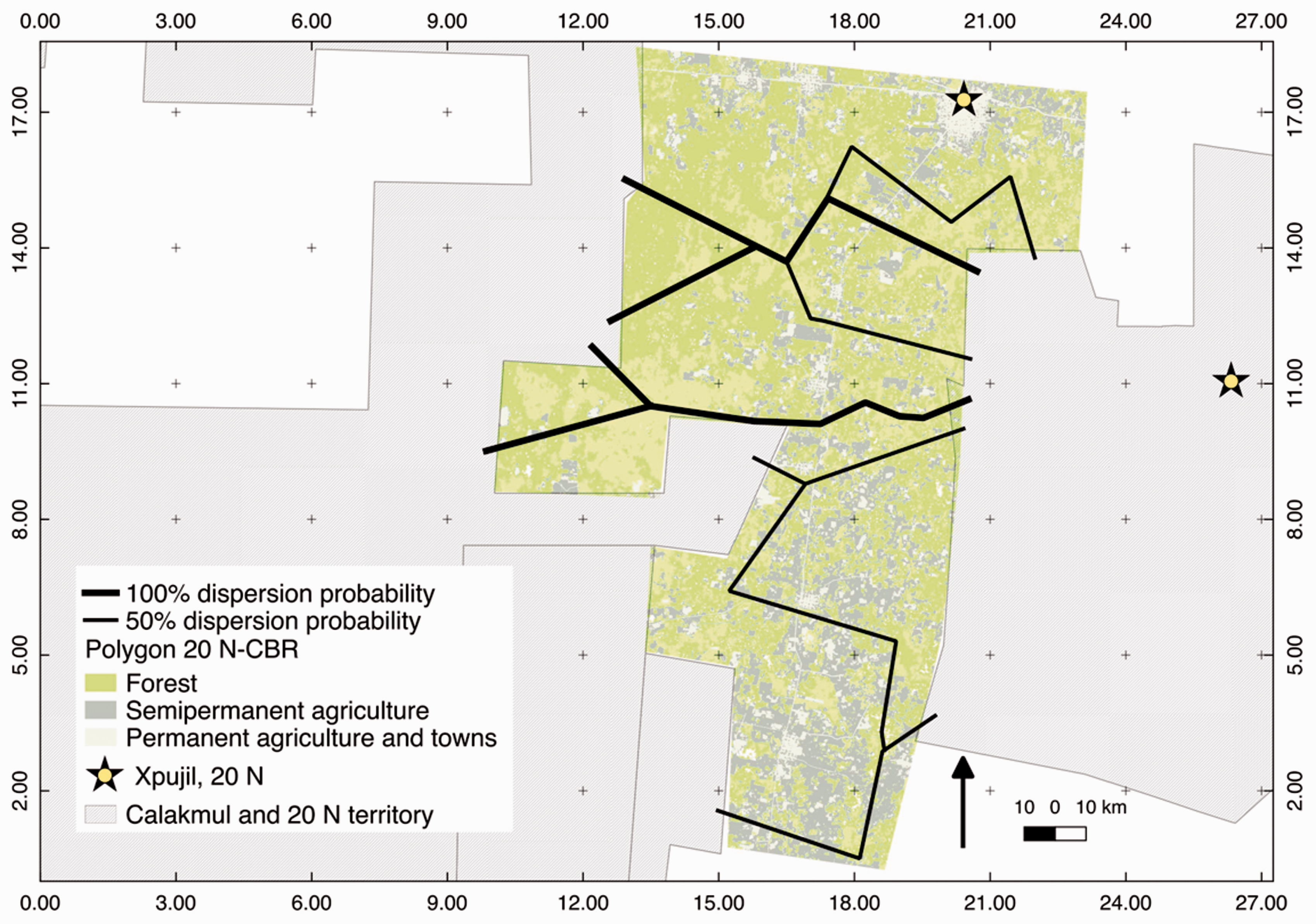
Priority connections between CBR and Ejido 20 de Noviembre, Campeche, Mexico. CBR = Calakmul Biosphere Reserve.

Priority connections between CBR and Ejido NB, Campeche, Mexico. CBR = Calakmul Biosphere Reserve; NB = Nuevo Becal.
Potential Habitat Remnants
The spatial units classification of potential habitat for tapirs in the areas between CBR and the two communities is shown in Figures 7 and 8. The most important nodes for 20 N were the core areas of Nodes 15 and 9 plus an extension of Node 1 toward nearby forest remnants (Priority 1, Figure 7). In the northeast of the study area, we identified three patches adjacent to the community that according to the CPI are relatively important nodes to maintain connectivity (Priority 3, Figure 7). However, the entire southern part of the study area is very fragmented, with extensive agricultural surfaces (Figure 7). NB had a higher IC and PC because the number of habitat patches in good condition occupied most of the landscape, and several habitat corridors that may function as connectors between remnants were detected (Figure 8).

Priority fragments and habitat connectivity between CBR and Ejido 20 de Noviembre, Campeche, Mexico. CBR = Calakmul Biosphere Reserve.

Priority fragments and habitat connectivity between CBR and Ejido NB, Campeche, Mexico. CBR = Calakmul Biosphere Reserve; NB = Nuevo Becal.
Discussion
Vegetation Cover and Land Use Classification
The proportion of forest cover was greater in the C-NB polygon than in C-20 N (80.5% and 71.2%, respectively). Medium forests conform most of these territories, followed by large areas of floodplain. C-NB supposes a better conserved area than C-20 N and therefore would be more favorable for tapir movements between community territories and CBR. Our results suggest that along federal road 261 Xpujil-Dzibalchen crossing the area C-NB, there is no evidence of a severe fragmentation process in spite of the presence of the town of Zoh Laguna (Ejido Álvaro Obregón), whose residents have their farming areas far away (19 km north). In the southwest of the study area, C-NB shows more evident fragmentation processes, as it happens in the town of Valentín Gómez Farías. However, this community still has large forested areas in good condition, allowing timber extraction, tourism activities (Isaac-Márquez et al., 2016), and probably, tapir crossings as well. In contrast to C-NB, the increase of human infrastructure and forest fragmentation on the section of federal highway 261 south of Xpujil is evident in C-20 N. Forest loss is more evident in the central and southern portions of the study area, as well as north of Xpujil (Figure 7).
Campeche state stands out among those with the highest deforestation rates in Mexico (30,000 ha/year; Céspedes-Flores & Moreno-Sánchez, 2010). A study conducted in the Mesoamerican Biological Corridor detected that in the Calakmul-Sian K’'an strip, the main cause of deforestation was seasonal agriculture (Díaz-Gallegos, Maas, & Velázquez, 2008). Ellis, Romero-Montero, and Hernández-Gómez (2015) estimated a deforestation rate of 0.2% in a 12-year period in communities within the Calakmul municipality. The primary causes of deforestation and forest fragmentation in this region are land use changes for livestock and agriculture (corn, beans, and chili peppers), and demographic growth (Ellis et al., 2017). The strong fragmentation process occurring in the C-20 N zone affects forest remnants of importance for tapirs since these fragments are immersed in an adverse matrix, which may lead to their local extinction in absence of dispersal routes. Although there are no published data on the use of these areas by tapirs yet, we compiled abundant references by residents and researchers about large mammals such as tapirs, jaguars, deer, and peccaries crossing out forest boundaries in this region (N. Carrillo, J. Pérez-Flores, S. Pérez-Cortez, M. Sanvicente, N. Arias-Domínguez, personal communication). These observations suggest that at least a portion of the agricultural matrix (especially abandoned farming plots where secondary vegetation grows) may be usable for tapirs to move between forest fragments. This is undoubtedly encouraging for tapir conservation considering the extensive areas covered by successional vegetation in different stages in the Calakmul region, in spite of the evident trends of forest fragmentation across the Yucatan Peninsula.
Landscape Connectivity
Our results suggest that the landscapes of our study sites are not optimal, but still usable for tapirs. In both sites, only three nodes turned out to be key in landscape connectivity and suitable for tapir use. Large tapir home ranges may be an issue in unprotected areas facing deforestation processes. As we found out in this study, the connectivity model for tapir habitat developed by Pérez-Chirinos (2008) in Nueva Palestina, Chiapas, identified only three optimal fragments for tapir use and a total of 19 connections of which only 10 had direct connection probabilities higher than 50%. Of the three strategic nodes detected in the C-20 N area, Node 9 appears important for landscape connectivity despite being very fragmented in its interior with an agricultural extension of 30.6% (Figure 3). Its importance may be due to its strategic location as a potential stepping stone to maintain connectivity between other nodes (e.g., Nodes 15 and 1), and contributing as a partial north-south corridor running from the 20 N community territory through CBR (Figure 3).
A similar conclusion was drawn by Lizcano, Pizarro, Cavelier, and Carmona (2002) who found that even small habitat patches may be relevant for the mountain tapir (Tapirus pinchaque) to improve connectivity between major fragments in the Colombian Andes.
Despite the limited number of optimal nodes for connectivity in our study area, shifting semipermanent farming areas may be allowing tapir movements between forest continuums in the Calakmul region (Carrillo et al., in review). Nevertheless, the low level of general connectivity in this region probably affects the persistence of high quality fragments by reducing tapir dispersal probabilities between fragments (Correa & Mendoza, 2013).
For tapirs, transit between fragments through an adverse matrix may be risky (De la Torre, Rivero, Camacho, & Álvarez-Márquez, 2018). Although distances between the three strategic patches are relatively short in both study areas, they are divided by federal highway 26 and adjacent urban areas. Since the remaining fragments are large extensions of forest, it is essential to maintain their interconnectivity to avoid isolation processes transforming them into preserved areas useless for the flow of species travelling long distances. Our analysis suggests that the tapir population within the 20 N territory has a higher risk of isolation and vulnerability to hunting and disease (Deyoung & Honeycutt, 2005) than that of NB. Although the extension of forest is still large in both study areas, patches smaller than 4 km2 probably will not be functional for tapir occupation in the long term according to the 4.1 km2 core area reported in Calakmul (Reyna-Hurtado et al., 2016) and a conservative edge effect 100 m from the fragment boundaries (Pérez-Chirinos, 2008). Assuming that a tapir needs a minimum forested area of 2 km2 to fulfill its basic habitat requirements (Naranjo, 2009), only seven fragments would be usable in the C-20 N zone and 10 in C-NB.
The connectivity between the forest of 20 N and CBR appears interrupted in the southern part of the study area. In this sector, there are three habitat patches important for landscape connectivity according to the indices computed (Figure 7). These patches are wider than the threshold distance required for tapir dispersal (4.1 km2, Reyna-Hurtado et al., 2016), and they help maintain a north-south connection. However, they have no longer the possibility of connecting to any other remnant to the east and west. Tapirs willing to venture through these remnants to disperse between community forests and CBR must cross agricultural zones, a federal highway and human settlements, which makes it a dangerous trip. Therefore, the south of the study area appears less suitable for the movement of tapirs between the two large continuums of forest. Since no forest patch in our study area is able to maintain by itself a viable tapir population in the long term (Correa & Mendoza, 2013; Naranjo, 2018), actions to improve connection between forest fragments are essential. These actions should be included in current and future territorial planning of the Calakmul municipality, considering for example, the creation and maintenance of wildlife crossways in strategic sites along the main roads. Tapirs are able to temporarily use a variety of habitat types including secondary vegetation, pastures, and crops within a forest matrix (Foerster & Vaughan, 2002; Reyna-Hurtado & Tanner, 2007). This ability may facilitate nocturnal movements between preserved areas as long as tapirs do not face high risks of being poached in open areas or hit by vehicles while crossing roads.
Population isolation is not an exclusive risk for Baird’s tapirs in Calakmul. Lowland tapirs (Tapirus terrestris) and mountain tapirs face similar situations in many locations across South America, where more efforts are needed to improve connectivity between protected areas and surrounding indigenous territories (Lizcano et al., 2002; Wallace, Ayala, & Vizcaya, 2012). CBR is connected in its southern part to the Maya Biosphere Reserve (MBR), the largest protected area in Guatemala. Garcia and Leonardo (2016) found that of 12 important forest remnants for tapirs throughout the Guatemalan territory, MBR is the one with the highest IIC (33.5). However, these authors observed a severe fragmentation process occurring in that region, threatening tapir habitat availability (Garcia & Leonardo, 2016). The relevance of MBR to maintain a viable tapir population in the Greater Maya Forest is undeniable. It is very important to increase the connectivity between MBR, CBR, and the remaining extensive forest patches throughout the Yucatan Peninsula to ensure the viability of the largest tapir population remaining north of the Amazon (García et al., 2016; Naranjo, 2009, 2018).
Implications for Conservation
This study integrates to a major effort for the conservation of endangered wildlife species in the Calakmul region of Campeche, Mexico. Deforestation, forest fragmentation, and unsustainable hunting are primary drivers of population decline for species such as Baird’s tapir, whose habitat connectivity was analyzed at landscape level. Considering the resolution of the images available for this analysis, we recognize that our results may need a more comprehensive field verification. However, we infer that connectivity has been severely reduced between most of the community territories and CBR due to land use change driven by the expansion of seasonal agriculture, livestock ranching, and urban sprawl in the region. It is encouraging to note that the local tapir population seems to be adapting to the current habitat mosaic of Calakmul, where extensive tracts of secondary vegetation appear usable as transit areas between forest fragments. Nonetheless, it is undeniable that forest cover loss likely represents a major driver of population isolation for tapirs and other large vertebrates with similar habitat requirements in the Greater Maya Forest. In this sense, analyzing the status and dynamics of the forest-agriculture habitat mosaics in Calakmul and other areas may be a useful indicator to assess the future distribution of tapirs. We suggest that landscape connectivity should be considered in community and municipal land planning projects in the Calakmul area. In addition, wildlife habitat conservation and restoration actions such as the creation and maintenance of wide forested corridors between communities and extant protected areas must be promoted and supported by state and federal environmental authorities. Tapirs are relatively tolerant to traditional farming (e.g., scattered corn fields within a forest matrix) and sustainable forestry practices, which may be encouraged over mechanized agriculture and extensive livestock production to mitigate deforestation and tapir habitat loss in rural and urban communities around the protected areas of the Calakmul region and beyond.
Footnotes
Acknowledgments
The authors thank staff of the Calakmul Biosphere Reserve and authorities of Ejido Nuevo Becal and Ejido 20 de Noviembre for facilitating access to the study areas and providing logistical support to carry out this investigation. The authors are grateful to the farmers of Calakmul and researches who kindly shared their experiences regarding tapirs and wildlife conservation. Antonio Jasso de la Rosa, Nicolás Arias Domínguez, and Ricardo Cauich Dzib collaborated in the fieldwork.
Declaration of Conflicting Interests
The author(s) declared no potential conflicts of interest with respect to the research, authorship, and/or publication of this article.
Funding
The author(s) disclosed receipt of the following financial support for the research, authorship, and/or publication of this article: The Rufford Foundation provided financial support through its “Rufford Small Grant” to carry out fieldwork. Idea Wild gave support in field material to the first author of this investigation. The National Council of Science and Technology granted a scholarship to the first author to pursue PhD studies.