
Abstract
Falls are a major problem for the elderly people leading to injury, disability, and even death. In this article, we propose a fall detection system that uses the acceleration sensor of a smartphone to detect a senior citizen falling in real time and to use the communication capabilities of the smartphone to notify the administrator of such an event. The proposed system conducts real-time location tracking using Google’s Map and 3D information to cope with a critical situation and to make an urgent intervention in an emergency. Since Google’s 3D mapping service can provide information on the surrounding buildings and their shapes with more precision than a 2D service or text-based service, it is possible to ensure a prompt response for senior citizens when such location information is available. To verify the validity and efficiency of this article, we measured the change in acceleration sensor value by classifying the subjects by age group and gender. As a result, we found that the signal vector magnitude value of the acceleration sensor value variation showed a great difference in daily life such as walking, running, sitting, and falling.
Keywords
Introduction
Advances in medical technology have resulted in an increase in the ratio of senior citizens around the world. In order to respond to such a change in demographics, the Google’s 3D map service with real-time location positioning technology can be applied to a U-Healthcare system.
Falls are one of the major causes of injury for the elderly people, 1 and as individuals reach an advanced age beyond 65, these become one of the most frequent causes of death. Thus, unintentional injuries caused by falls among seniors are a major public health problem. 2 As a result, many studies have been carried out to detect such falling injuries and to quickly determine the location of the individual. 3 Current technology affords greater possibility to protect seniors, and low-powered components make it possible to realize wearable monitoring devices. 3 Therefore, the deployment of automatic, reliable, and cost-efficient fall detection systems (FDSs) has become a significant research topic during the last decade. 2
This article proposes a novel real-time FDS for seniors, which uses the acceleration sensor and quickly notifies the administrator of such an event through the smartphone. Several kinds of fall detection methods exist and these can be divided into two methods according to the detection method. The first kind of detection method detects a fall using information from an image, whereas the second kind of detection method detects a fall by attaching sensors to the person who is at risk of falling. 4 Falin et al. 3 proposed an FDS that is based on a wearable device placed on the individual’s waist. Anania et al. 5 presented a novel method that uses a triaxial accelerometer to detect a senior falling. Dai et al. 6 proposed using a mobile phone as a platform to develop a pervasive FDS.
We also present a real-time location tracking system for seniors, which uses the acceleration sensors in smartphones. The proposed system notifies the administrator when a fall has been detected, and it executes real-time location tracking when the subject moves using Google’s 3D mapping system. The real-time falling information obtained from the devices is used to address any critical situations that occur afterward and to make intervene urgently in the case of an emergency.
Since Google’s 3D mapping service can provide information on the surrounding buildings, including their shapes, with more precision that visual 2D services or text-based service, it is possible to promptly intervene on behalf of seniors when such location information is available. Finally, the efficiency and validity of the proposed method are evaluated by carrying out the corresponding experiments.
The rest of this article is organized as follows. Related works are discussed in the following section, and in “Methodology section,” the design and implementation of suggested method are described along with the principles of its modules and algorithm. “Experiments” section presents the results of the evaluation to verify the suitability of our proposed system, and the conclusions are provided in the final section.
Related work
Fall detection algorithm
Falls by seniors are a major public health problem and that have recently been extensively studied. 7 Most research on falls uses accelerometers to determine the change in the magnitude of the acceleration, and a fall is detected when the acceleration exceeds a critical threshold. 8
Mobile FDSs can be divided into two methods according to the detecting method. The first determines that a fall has occurred by analyzing an image, and the second detects a fall by attaching sensors to the person who is at risk of falling. Generally, three-axis accelerometers are attached to the specific parts of the body, including the waist, wrist, or trunk, and data are collected for each axis. If the value collected from the acceleration sensors exceeds a certain critical point, the situation is determined as a fall. The method that is used to combine, classify, and analyze the values for the x-, y-, and z-axes is different in each study.
Lin et al. 9 proposed a compressed-domain, vision-based fall detection scheme that was found to have a fall detection rate of 93%. However, such methods have a disadvantage in that they involve excessive network use since an image obtained by a camcorder is transmitted through network. The fall contained in the image can be detected as shown in Figure 1. Juang and Chang 10 proposed a fall detection method that classifies the type of fall from information contained in the image. Figure 1 shows the input images, result from the background model, and moving, segmented people after carrying out a morphological operation. 10 Nevertheless, this method infringes on privacy since the private life of the individual is continually exposed to the image. It also has a disadvantage in that multiple image-capture devices are required if the movement radius of the person is too large to detect a fall.

Feature-based compressed-domain fall-down detection. 10
Hwang et al. 11 developed a FDS that makes use of a chest attachment. They used an ambulatory monitoring system with Bluetooth to monitor the risk of a fall in seniors. They also performed experiments and showed that this system has an accuracy of 96.7%. However, this system has some limitations in that women may feel uncomfortable when they wear the device on their chests. Figure 2 shows an ambulatory system for fall detection. Anania et al. 5 presented a novel method for human fall detection that uses a triaxial accelerometer, and this method has been shown to attain a good result with a sensitivity of 98%. Lindemann et al. 12 suggested a fall detection method worn on the head to measure the acceleration during activities of daily living to detect falls. The accelerometers were integrated into a hearing aid housing that was fixed behind the ear using a rubber sling. This method has an advantage in that the feeling of a foreign material being attached is less than that for a sensor at the waist or chest. However, this is also inconvenient to wear and the feeling of foreign material is significant for a person who wears a pair of eyeglasses. Figure 3 shows the fall detector with a coordinate system.

Ambulatory system for fall detection. 11 (a) Developed system and Bluetooth module and (b) system attached on the chest with a belt.

Fall detector with a coordinate system. 12
However, the method suggested in this study does not require the use of a separate device to determine whether or not a fall has occurred, because it uses a smartphone to detect the fall. Since the location of the smartphone is always changing, the probability of failure for fall detection with a smartphone can be quite high.
Therefore, we present a real-time FDS for elderly seniors, which uses the acceleration sensors in smartphones. This study suggests a “real-time location tracking system” for fall detection using a smartphone with sensors inside. This system can communicate and always be carried by the person who is at risk of falling location tracking system.
The system proposed by Lindemann et al., 12 does not incur any unnecessary service charges, since it provides a dedicated low-cost terminal for location tracking and provides the target guardian and regional emergency center with the appropriate means to take emergency measures to determine the location of the user by implementing a 2D method. Figure 4(a) shows a screenshot of the results of an active emergency call service using the 2D method in the study by Lindemann et al. 12 and this shows it is difficult to track the location of the target at a glance and that this system is also slower.
A study based on multiple sensors in a u-Home environment is described in the study by Hee-Jeong et al. 13 As shown in Figure 4(b), the location tracking method and alerting the service provide the guardian with the moving route of the senior by simply sending SMS messages, so it is difficult to determine the precise location.
Thus, this study attempts to design and implement a “3D location tracking system” by improving upon these 2D and text message services to provide information on the location more quickly.
Methodology
This section describes a method with which to identify a fall by means of a smartphone and to track the location when a fall has been recognized.
Fall detection algorithm
Existing studies fixed accelerometers on the human body, as shown in Figure 5, to determine whether a fall has occurred by analyzing the values of the x, y, and z acceleration. A fall can be identified if the accelerometer indicates that the body suddenly moves downward and exceeds a certain limit in the vertical direction.

Fall detection method using a fixed accelerometer sensors. 14
However, since the existing method requires the use of an additional device to identify that a senior has fallen, it is difficult for such a system to be implemented. However, the method proposed in this study can easily identify whether there is a fall has occurred by only using a smartphone without any additional device.
The method used in this study analyzes the signal vector magnitude (SVM) to detect a fall regardless of the direction of the acceleration of the smartphone. The total SVM is defined as follows 8,14,15

where Ax , Ay , and Az are the acceleration (g) in the x-, y-, and z-axes, respectively.
When there is a movement by the senior, the SVM value changes. If the movement is large and fast, the SVM value increases. If the senior falls, the change in the value is very large, and since the change can be discriminated from other changes due to everyday living, it is possible to detect a fall. In addition, the critical point to determine that a fall has occurred can be controlled by combining sensor data at the time of a fall. As a result, there would be no misjudgments for the fall. In this way, it is possible to detect a fall without keeping the smartphone fixed. In other words, the senior can carry a smartphone in their pants’ pocket since it is possible to detect a fall without keeping the smartphone fixed in a specific direction. At this time, the slope sensor performs an auxiliary role in detecting the fall and contributes to improving the accuracy by preventing an incorrect detection of a fall.
Values measured by the sensors on the smartphone
The data measured by the relevant sensors on the smartphone represent values (or gravity added to the smartphone). Therefore, the acceleration is measured using data generated when the smartphone moves, then saved and calculated separately. The basic acceleration is calculated by subtracting the value of the present movement from the immediately preceding movement, and the method to measure each axis is given in Table 1.
Method to measure each axis (x-, y-, z-axes) (Authors’ work).

Regarding the acceleration in the x-, y-, and z-axes, the values for the change in the smartphone are different depending on the real data that is captured. For example, the value for the z-axis decreases if the screen moves toward the sky, while the acceleration increases if the screen heads toward the sky, on the contrary.
Real-time location tracking system for fall detection
The suggested system allows for real-time monitoring of an elderly person who may have fallen. When the system detects a risk of falling, it determines the status of the fall using the smartphone and sends the location obtained from the GPS sensor of the smartphone. This system reduces the error range for the location identification by developing a logic that automatically provides location services to fit a given situation. In other words, when the location of the senior has been determined, the system uses Wi-Fi information when the person is inside a building and it uses GPS if the person is outside the building. Therefore, the error range will decrease.
The system consists of a location detection server, location tracking sensor, and smartphone acceleration sensor. Figure 6 shows the overall process of system.

Overall process for the real-time location tracking system (Authors’ work)
Principles of development
First, if a fall has been detected for the senior, an optimal location provider is selected from the smartphone terminal and the information of the current location is provided. Next, the current location is sent to the server for storage. At the same time, the location is sent from the server to the administrator for display.
REpresentational State Transfer (REST) is used to establish communication between the smartphone and the server. REST reads a web page consisting of an XML file to collect the desired information, and the user can easily obtain the information through a web browser if he or she knows the URL of the page. It consists of a data structure that uses web technology and protocols including HTTP and XML, and it is easier to use than Simple Object Access Protocol and is similar to the information-editing function of the RDF Site Summary that describes the information on a website.
Most of the logical components used in this system are implemented in the C# language, and ASP.NET was used for the web service. Asynchronous JavaScript and XML (AJAX), jQuery, REST services, Google Maps and Google Earth API, and Java API were used to implement the service, and MySQL was used for the DB.
AJAX is used to display an indicator of the next location of the senior in Google Maps with. As the indicator moves, the Google Earth model rotates. The browser plug-in for Google Earth was used to generate a 3D view, and Google Maps was used for 2D.
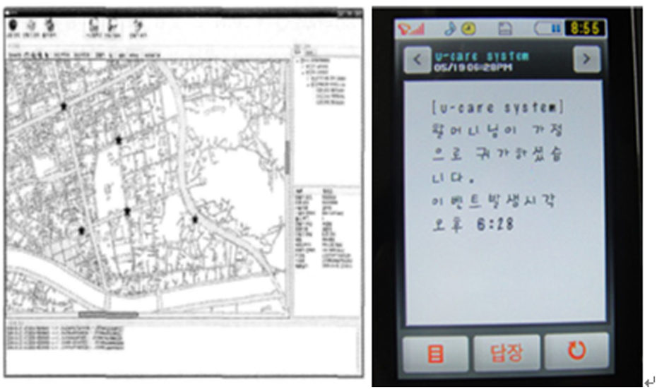
The RESTful service was used to obtain information on the latest location, and jQuery was used to update the map with the last information from the browser. A specific REST service that can obtain the location information was used to call out AJAX. The entire process generates an animation each second for the desired time in the program. The 3D model in Google Earth is used for the location, and it moves with the corresponding animation. In addition, as the indicator moves, the direction changes in the map. The implementation in Google Maps 3D is shown as a screenshot in Figure 7.

Screenshot for the Google Maps 3D location tracking system (Authors’ work).
Experiments
The acceleration sensor of a smartphone measures the movement of objects and can be processed into data having different properties using the movement. For example, when measuring only the general motion of an object, 9.81 should be subtracted from the data of the axis affected by gravity. To measure the acceleration, two or more data must be collected and operated. The acceleration measurement is described in the “Methodology” section. The purpose of this experiment is to prove the efficiency and accuracy of the system by collecting data at the time of a fall and the movement that can be considered to occur during everyday living.
Figure 8 is a graph showing the fall data collected by women in their 60s when they fall down. They are shown the change in acceleration when women in their 60s walk down a certain distance on a smartphone and fall down. The results of the experiment shown in Figure 8 indicate that the value of the acceleration sensor changes according to the movement of the test subject. The values from 0 to 16th are shown as common movements of everyday living, such as walking or sitting. The value rapidly increases at the 17th s, and this rapid increase in the acceleration happens when the subject falls. This experiment proves that a rapid response to an emergency situation is possible by defining a critical threshold for value obtained from the acceleration sensor to send the location information to the system operator after determining a fall that occurs once the value exceeds threshold.

Variation in the acceleration after a fall (Authors’ work).
Experimental environment
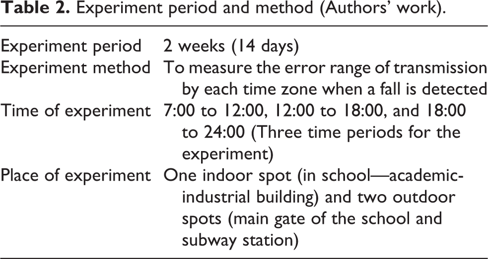
An experiment was performed near a school and a subway station with 10 students. The experiment evaluated the error range of the location at a fall at the designated places, with two outdoors and one indoor. In addition, to determine how location tracking differs according to a mobile obstacle, a test was conducted by dividing the activity time of the senior into three time periods: 7:00 to 12:00, 12:00 to 18:00, and 18:00 to 24:00. The reason for which the test was conducted by dividing the time zones is that since the current location is obtained with a Wi-Fi transmitter indoors, the AP signal strength that is transmitted from the wireless LAN environment where mobile obstacles exist decreases when people are present and is amplified or scattered at 1 p.m. when there are many mobile obstacles. Therefore, a null signal strength may be received by the moving object. In order to measure the changes according to whether there is a mobile obstacle, the time periods were divided in this experiment. Details on the experiment period and method are summarized in Table 2.
Experiment period and method (Authors’ work).
Results of experiment
The average of the values for the error range of the location tracking was calculated in front of station and at the main gate of the school and academic-industrial building over a period of 2 weeks. The average indoor and outdoor error ranges for the fall location tracking system, that is, proposed in this study are shown in Figure 9.
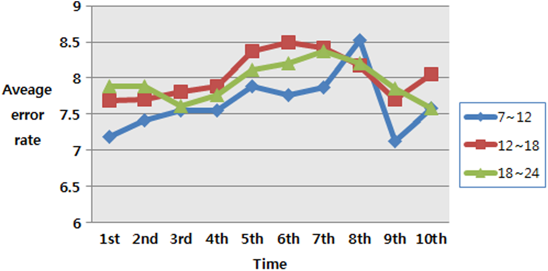
Average error rate for location tracking per time zone (Authors’ work).
The results of the experiment indicate that the overall accuracy of the system was within 9 m, and the error range from 12:00 to 18:00 was larger than that for the other time periods. However, the accuracy in the location tracking was not any lower. Thus, if there is a high density of Wi-Fi installations, the accuracy of the location tracking system is excellent in any area due to the visual effects provided by Google Maps in 3D, and the speed is superior to that of the other methods in existing studies.
Conclusion
For the purpose of improving the quality of medical care, more and more health care systems are intensely increasing. 16 In this article, we propose a novel real-time FDS for seniors, which uses the acceleration sensor and quickly notifies the administrator of such an event through the smartphone. Therefore, it is possible to find the position more quickly in the case of emergency and to track the real-time position, so that the elderly person will be able to receive emergency treatment in the case of dangerous situation while moving in the vehicle.
Existing studies in the literature have proposed methods that require additional devices to determine whether or not a senior has fallen using accelerometers fixed on the body of a person. The real-time location tracking system proposed in this study uses Google’s 3D mapping services to provide a location tracking system. These services applied to an FDS, since the location and the shape of a building can be seen at a glance in contrast with the existing location tracking systems. Real-time location tracking is thus possible in an emergency situation for first aid to be administered when a senior is placed in a dangerous condition. The proposed FDS does not use a fixed sensor, but instead determines the fall using an accelerometer and a tilt sensor built into mobile devices, such as a smartphone, that the general public can easily use.
The methods from the existing studies to track the location of an indoor user in a wireless environment show an error range of about 1 m if separate special wireless equipment is used. However, since location tracking for indoor users requires a fixed target environment with separate equipment, as explained earlier, its usefulness is somewhat poor to provide the user’s location in a real environment.
Therefore, this study used a location tracking technique that can be applied in general and non-stationary environments using a wireless LAN AP only, this system achieved excellent results in terms of accuracy and speed. For future research, it will be necessary to increase the precision of the smartphone’s tilt sensor and fall detection. The tilt sensor plays a secondary role in determining the fall, but the fall is not determined only by the tilt sensor itself, so an ongoing study of is necessary. Since a smartphone’s accelerometer and tilt sensors operate constantly, it is necessary to study the issue of battery consumption. In the future, it is necessary to apply SVM to the subjects of more gender and age group. Since the acceleration and tilt sensors of the smartphone always operate, it is necessary to study the battery consumption problem.
Footnotes
Declaration of Conflicting Interests
The author(s) declared no potential conflicts of interest with respect to the research, authorship, and/or publication of this article.
Funding
The author(s) received no financial support for the research, authorship, and/or publication of this article.