
Abstract
This article is to study the impact of deepening on transportation efficiency in Yangtze River Estuary. Due to geographic conditions and administrative regulations, navigation system at the estuary can be formulated as a state-dependent queuing network with interdependent channels, multi-type vessels, and priority disciplines. We use simulation modeling to deal with this complex maritime system. Vessel calls to terminals, tidal and navigational rules, and vessel profiles are considered and a “dual clock” mechanism is designed to solve the pre-queuing optimization. The model is specifically built to stimulate vessel traffic on performance measures, including vessel waiting time and channel utilization. By performing scenario and policy analyses, several proposed deepening schemes are evaluated and compared.
Keywords
Introduction
The Yangtze River, or the Changjiang River, is one of the world’s longest inland waterways. It connects the most developed metropolises in east, central and west China and is known as “The Golden Waterway”. Therefore, the transport system of the Yangtze River is busy all the year round and the Yangtze River Estuary is the key point of the system. The importance of Yangtze River on inland waterway transportation in China can refer to Zhang and Zhao 1 and Liu. 2
As the cargo volume, vessel traffic and the number of large-scale ships in the Yangtze River Estuary increase, the decline of service level and the extension of vessel waiting time are becoming serious problems and drawn to the government’s attention. Implementation of a dredging project, which is planned to deepen the South Channel with current depth of 5.5 m and relieve the burden of large-scale vessels at the North deep water channel, has been proposed. A reasonable allocation of vessels in two channels is required and the key problem is to decide the depth of the proposed deepening project at the South Channel: 6.5, 7, or 7.5 m.
Navigational operations at Yangtze River Estuary are a complex dynamic system, where managerial decisions depend on vessel profile such as draft, width, length. Moreover, in accordance with administrative regulations, there are some navigational rules: multiple arriving ultra-wide vessels may cause the channels’ temporary shut-down, larger cruise vessels have higher priority, deep-draft vessels have to take the tide, and so on. Existing theoretical research on this complex dynamic system is relatively scarce, and it is necessary to use the computer software and simulation modeling to study performance measures of maritime system in the Yangtze River Estuary, which provide support for decision-making of the deepening project in the South Channel.
According to the characteristics of Yangtze Estuary channel network and ship navigation, a computer simulation model of Yangtze Estuary channel state-dependent queuing network service system is constructed, and the characteristics and optimization of Yangtze Estuary channel network service system are simulated. In the simulation modeling, this article designs two sets of clock systems and the updating mechanism of the maximum ship width of upstream and downstream. That is, two kinds of entities use one set of clocks in one model. These two sets of clock mechanisms can effectively solve the problems of ship pre-declaration mechanism and ultra-wide ship state-dependent channel vacation during the navigation control period of the North Channel of the Yangtze Estuary. Simulation and optimization results in this article can provide reference for the decision-making of the regulation project of the South Channel of the Yangtze Estuary.
In this article, we use simulation modeling to deal with this complex maritime system. Vessel calls to terminals, tidal and navigational rules, and vessel profiles are considered and a “dual clock” mechanism is designed to solve the pre-queuing optimization. The model is specifically built to stimulate vessel traffic on performance measures, including vessel waiting time and channel utilization. By performing scenario and policy analyses, several proposed deepening schemes are evaluated.
Literature review
Due to geographic conditions at Yangtze River Estuary and navigational rules, the waterway system is a complex queuing network, with inter-dependent servers and priority queuing disciplines. Therefore, analytic models are less applied by researchers, comparing with simulation models. Wang and Schonfeld 3 , 4 consider simulation models of a waterway system with multiple interdependent channels, where only some may be accessible and shut down others. Wu et al. 5 consider analysis and design of synchronization heterogeneous network.
The literature on simulation of vessel traffic is burgeoning and provides tools for scenario and policy analyses. Köse et al. 6 model the marine traffic of the Strait of Istanbul using simulation and study the effect of arrival rates on waiting times. Merrick et al. 7 perform a traffic density analysis on the proposed ferry service expansion in San Francisco Bay using maritime simulation model as well, which provides a tool for policy analysis on expansion projects. Similarly, Grigalunas et al. 8 consider the proposed deepening project at Delaware channel. Almaz et al. 9 use simulation model to investigate the transit maritime traffic in the Strait of Istanbul and perform scenario analysis. Özbaş and Or 10 developed extensive simulation models including vessel profile such as types, cargo characteristics, pilot and tugboat services, traffic rules, and environmental conditions and investigated effects of numerous factors on different performance measures. Smith et al. 11 consider simulation of alternative approaches to relieve congestion at locks in the Mississippi River.
Meanwhile, simulation techniques on vessel traffic are developing. Cortés et al. 12 simulated both the freight traffic and terminal logistics for Port of Seville, Spain using Arena software focusing on port utilization and recommend that dredging is to accommodate bigger vessels for potential growth. Dragović et al. 13 perform a proposed simulation-based operational policy for cruise ships in the port of Kotor, and more simulation modeling in ports and container terminals can refer to Somanathan et al. 14 and Keceli, 15 as well as Dragović et al. 16 for a review. Ince and Topuz 17 consider modeling and simulation for safe and efficient navigation in narrow waterways. On the other hand, some researchers develop simulation models for evaluation of vessel traffic. Yeo et al. 18 evaluate the marine traffic congestion of north harbor in Busan port. Quy et al. 19 use a risk-and-simulation-based optimization of channel depths at entrance channel of Cam Pha Coal Port. Our paper is mostly close to Almaz and Altiok, 20 who use a simulation model and the Arena software to study the vessel traffic in Delaware River and the impact of deepening on port performance. More techniques on Arena software can refer to Altiok and Melamed. 21
For empirical study of traffic in a transportation system, Zhang 22 use matrix geometric method to model the traffic flow at tollbooth plaza in China, and Gupta et al. 23 perform identification of statistical patterns in complex systems via symbolic time-series analysis. The study on Yangtze River waterway is growing such as Zhang and Zhao 1 and Liu. 2 In this article, we also use the AIS system to track and record the navigational activities of vessels using a radar system and related mechanism can refer to Zhang and Wang24–26 and Hu et al. 27
Waterway system at Yangtze River Estuary
Yangtze River Estuary channels
At present, the Yangtze River Estuary is a multi-channel waterway system, composed of a main channel (main channel), two auxiliary (south channel and north port auxiliary channel) and (north branch and other small ship waterway), see Figure 1.

Yangtze River Estuary navigation system.
Deep water channel or North Channel: with a depth of 12.5m and able to admit two-way navigation for fully loaded 50,000t-class (11.5m draft) container vessels against tide and fully loaded 50,000t-class bulk carriers along tide, as well as one-way navigation for several types ships along tide, including fully loaded 100,000t-class container vessels, fully loaded 100,000t-class bulk carriers and partially loaded 200,000t-class bulk carriers. On the other hand, with a width of 350-400m and under navigational regulations: vessels of the same direction are not allowed for over take, the sum of widths of two vessels of opposite directions shall not exceed 80m, and only one-way navigation is permitted otherwise. Therefore, we consider deep water channel as a conditional two-way channel.
Main channel or South Channel: the depth of the upper section of this channel is about 10.0 m, and the depth of the lower section is only about 5.5 m. It is the main channel for small-scale vessels and unloaded large-scale vessels entering the Yangtze River Estuary. In this channel, the waterway is sufficiently wide, allowing for over-take of vessels navigating in the same direction, and is considered as a “two-way 4 or 6 lane” channel.
Vessel profile
In the Yangtze River Estuary navigation system, vessels mainly pass through the South Channel and the North Channel. According to AIS (a radar and GPS-based system to track and record the navigation of vessels) statistics, in 2015, vessels across Yangtze River Estuary consist of 193,000 cargo ship with 88.1% of the total number (including about 150,000 vessels bulk carriers, container ships and general cargo ships with 69% of the total, 3.11 million tankers with 14% of the total, 122 million dangerous cargo with 5% of the total); 1400 passengers or cruise liners with 1% of the total; 2.53 million other ships (including public ships, engineering ships, etc.) with 11% of the total.
Tidal activities
Tidal activities at Yangtze River Estuary is regular half-day tide outbound and irregular half-day tide inbound. According to observational data of two tide stations of Hengsha and Jigujiao, the tidal level is 1.5, 2, and 2.5 m, respectively. The tide at the estuary is fitted with the ARIMA

Tidal variation model of Yangtze River Estuary.
Navigational rules
Navigational rules are subject to a series of administrative regulations and complicated. This research focuses on rules as follows:
North Channel only allows for navigation of vessel with draft larger than 7.0 m and otherwise only permitted in the South Channel.
The minimum time interval for vessels to enter the North Channel (including upstream and downstream) is not less than 6 min; the vessels in the North Channel shall navigate in order; the minimum distance between two vessels is not less than 1 nautical mile; over-take is not allowed; the minimum spacing between any two ships is six times of the vessel length.
The maximum vessel speed in the North Channel shall not exceed 15 knot, and the maximum speed in the Nangang channel shall not exceed 12 knot; according to analysis on AIS data, the average vessel speed in the deep water channel is 9.0–9.7 knot, while the average speed in other channels is 8.7 knot.
The distance between two vessels in the North Channel shall not exceed 80 m, and otherwise, only it is one-way navigable; as some vessels have widths greater than 40m, to ensure a safe and efficient navigation for the North Channel, all vessels during the high tide period (no matter upstream or downstream) shall be at least 12 hours in advance to apply online for navigation permit; once the application is approved, vessels shall enter the North Channel at a specific time; otherwise, pass in North Channel is not issued.
Every day both upstream and downstream navigation have two control periods: the control period for upstream navigation is from 7 to 5 hours prior to two climax tides; the control period for downstream navigation is from 1 hour prior to the climax to 1 hour after the climax; vessels in the deep Nangang channel do not have to use tide activities; the standard of tide level for navigation shall be chosen as 1.5m, 2.0m or 2.5m.
Simulation model
This article studies the impact of a deepening project in the South Channel on navigational performances of the South Channel itself, the North Channel and the Yangtze River Estuary navigation system as a whole.
With an increase of vessel size and trade growth, there is an increase of vessel arrival rate, the North Channel utilization, vessel waiting time, and losses.
The South Channel is deepened by 1.0 m (from 5.5 to 6.5 m), 1.5 m (from 5.5 to 7 m), or 2.0 m (from 5.5 to 7.5 m) and its impact on the North Channel utilization and vessel waiting time and the economic benefit of South Channel deepening project.
With the increase in vessel size and trade, there is an increase of vessel arrival rate, and without deepening the South Channel, the change of the North Channel navigational rules and queuing rules has impact on the North Channel utilization.
The model application analysis is described in detail in the subsequent parts of this article. Considering the factors such as channel draft and ship width, tide, navigation safety rules and various ship types, it is most appropriate to use computer simulation to study the Yangtze River Estuary navigation service system. The simulation model was developed using Arena 14.0 simulation software.
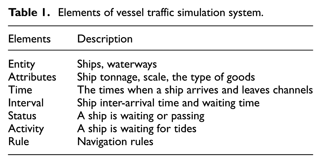
Stimulation elements
The simulation model includes all types of ships, ship profile (vessel length, width, draft, etc.), ship arrival patterns, relevant navigation management rules, tidal activities, North Channel ship pre-declaration. Queuing optimization management strategy is also included in the model.
Observational field data are derived from the 2014–2015 Shanghai Maritime Bureau Yangtze River Estuary AIS system. The model inputs include the ship’s arrival time, the type of vessels, the length and draft of the ship, the tonnage of the ship, and the duration of navigation. The distribution of the inputs is fitted by statistical analysis. To simulate tidal activities, we use historical date derived from the Yangtze River Estuary Waterway Authority. The details of the simulation system components are shown in Table 1.
Elements of vessel traffic simulation system.
Simulation system flow design
In accordance to navigation rules, we have design simulation system processes as shown in Figures 3–6.

Upstream ship simulation process.

Downstream ship simulation process.

Upstream ultra-wide vessel in North Channel.
Downstream process of ultra-wide vessel in North Channel.
Influence of ultra-wide vessel in North Channel
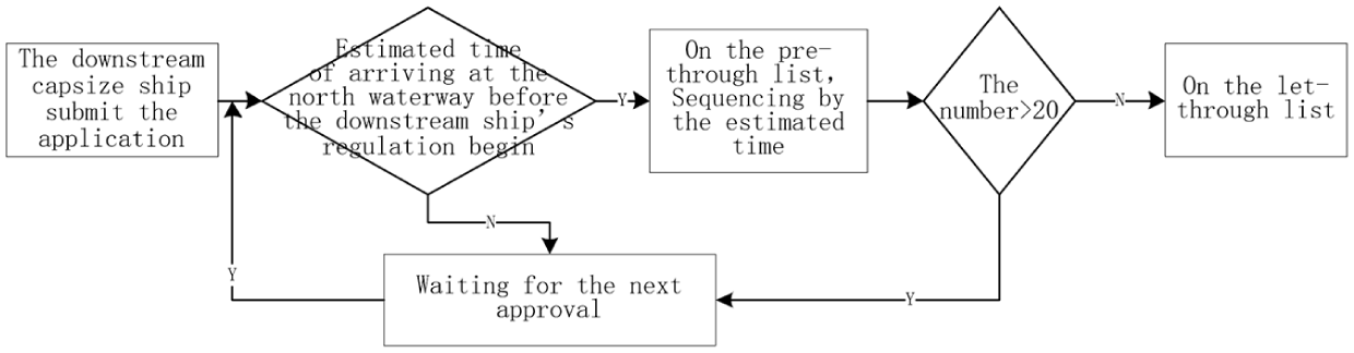
Due to the presence of ultra-wide ships, it causes the North Channel to be a one-way channel or a conditional two-way channel based on the widths of two ships from two directions. According to the conditions of the North Channel, the Yangtze River Estuary tidal activities, and traffic control policy of ships, the influence of ultra-wide vessels on the North Channel service is analyzed, as shown in Figure 7.

Tide, control, and ultra-wide boat.
From Figure 7, we can observe that starting at 8:00 am, there are climax tides every other 12 hours (6 hours’ low tide period and 6 hours’ high tide period). The red area indicates the longest passage time interval provided for the ultra-wide vessels,
Model structure
To present and study the present situation of the ship traffic system in the Yangtze River Estuary, we focus on a key technical problem of the simulation model: the occurrence and operation of random events generated in the waterway system.
Arrival process
In our ship generators, a ship (upstream or downstream) is randomly generated according to empirical distributions of eight types of ship arrivals. For the upstream, if the draft exceeds 7 m, the ship can enter the North Channel and otherwise shall enter the South Channel. We simulate the arrival process of ships based on its profile including draft, width, length and types (bulk, tanker ship, or container ship) as shown in Figure 8. Specifically, Figure 8(a) and 8(c) depict the relationship between width and draft for bulk and tanker ship and for container ship, respectively while Figure 8(b) and 8(d) depict the relationship between length and draft for bulk and tanker ship and for container ship, respectively.
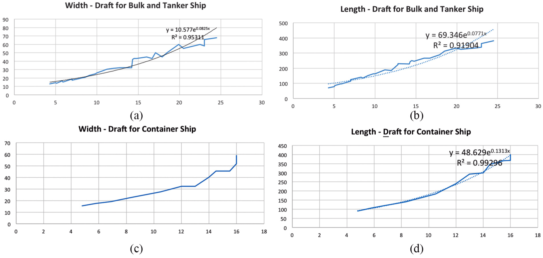
The relationship between draft and width or length.
Design of ultra-wide vessel mechanism
This system adopts a “dual clock” mechanism design: the simulation model generates two entities and each uses a set of clocks, as shown in Figure 9.

Dual clock system and the upper and lower row maximum width update mechanism.
That is, as soon as the simulation starts, it generates an entity, which then split into the ship entity and ship information entity. These two types of entities have the same attribute definition and initial value. As shown in Figure 9, during the simulation, the ship information entity runs according to the system simulation clock and searches for the maximum width of the ultra-wide vessel
The main purpose of designing the above “dual-clock” mechanism is to obtain informations for upstream and downstream ultra-wide ships 10 hours in advance. As a result, ships in the North Channel during control periods can be arranged. We are therefor able to simulate the application mechanism for ships during control periods and navigational rules on ultra-wide vessels.
Queue optimization of North Channel
When the list of ships that apply for navigation during control periods is decided, we need to arrange them in an appropriate order. The purpose is to admit as many vessels in the North Channel as possible under restrictions on channel depth and to minimize the passing time. According to the ship draft and the speed regulation of the North Channel, draft constraints of time intervals for vessels passing through the North Channel are


where
According to the above formula, we calculate the tidal table of the Hengsha and Jigujiao and use the vessel draft to calculate times when each vessel can safely pass the North Channel during time interval
It can also be obtained the maximum draft
Performance measures
This simulation model considers the following indicators as performance measures, including channel utilization and service level. Related statistics are derived during or after the simulation process.
Channel utilization. Channel utilization is an indicator reflecting the degree of busy state of the channel. The utilization rate of the channel section is related to the number of vessels, vessel length, vessel speed, the safe spacing, and annual operating time of the channel, as defined

where
Vessel average waiting time. The vessel average waiting time is an indicator reflecting the service level of the channel system, and it is also the economic basis for evaluation of the waterway.
Simulation procedure
Simulation is run on Arena 14.0 and the procedure is as follows:
Step 1: Start the simulation software.
Step 2: Input parameters. In the parameter input dialog box, the actual arrival rate, navigation rules, hydrology, and other conditions of the ship in 2015 are input, and the simulation time is set to be three times as long as possible to reduce the impact of the initial value of the simulation system experiment.
Step 3: Run the simulation model and record results in steady state. Usually in last simulation rounds (1/3 of the total ), the system becomes stable.
Step 4: Output the simulation model results, such as the flow rate, ship type structure, scale structure, average waiting time, total waiting time, and utilization ratio of the channel, and analyze the error and confidence with the actual data of the Yangtze Estuary waterway system in 2015, so that the confidence is above 95%.
Step 5: Repeated experiments are used to make the variance of the experimental results within the allowable range. In this article, the simulation results are repeated 100 times; variance analysis and confidence analysis are carried out, so that the confidence is more than 95%.
Step 6: Confirm the validity of the simulation model.
Scenario assumptions
Scenario-based policy analyses are as follows:
Scenario A. Under current navigational conditions and an increase of vessel scale and traffic flow. The depth of South Channel remains 5.5 m and vessels with draft more than 7.0 m are not allowed for navigation in the North Channel.
Scenario B. Deepen the South Channel by 1.0 m and an increase of vessel scale and traffic flow. The depth of South Channel increases from 5.5 to 6.5 m and vessels with draft less than 8.0 m are allowed for navigation in the North Channel.
Scenario C. Deepen the South Channel by 1.5 m and an increase of vessel scale and traffic flow. The depth of South Channel increases from 5.5 to 7.0 m and vessels with draft less than 8.5 m are allowed for navigation in the North Channel.
Scenario D. Deepen the South Channel by 2.0 m and an increase of vessel scale and traffic flow. The depth of South Channel increases from 5.5 to 7.5 m and vessels with draft less than 9.0 m are allowed for navigation in the North Channel.
Vessel traffic growth
Trend of future trade in Yangtze River Estuary is forecast in the deepening analysis report of the Transportation Planning and Research Institute, Ministry of Transport, China.
This report predicts the expected growth every 5 years, from 2016 to 2035. Based on this analysis, the increase rates during each 5-year period are given in Table 2. Therefore, vessel arrival patterns for the next 20 years are estimated annually and incorporated for all vessel types in the simulation model. Note that the rates given in the table are annual and compounded throughout 20 years.
Estimate of future vessel arrival.

LNG: liquefied natural gas
Simulation output
Under Scenarios A, B, C and D, we predict the number of vessels in the North Channel, the waiting time, and the Channel utilization rate in 2020, 2025, 2030 and 2035 using Arena 14.0. The output are shown in Tables 3–6.
Output of Scenario A.

Output of Scenario B.

Output of Scenario C.

Output of Scenario D.
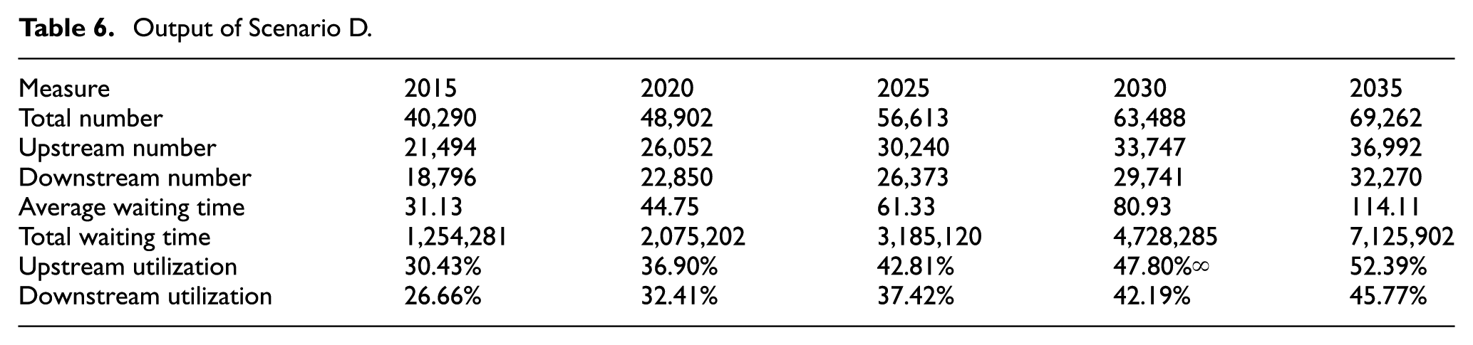
In the case of Scenario A, the utilization rate of the upper channel in the North Channel from 2015 to 2035 increased from 53.13% to 92.35%. Before 2020, the utilization rate of the channel would be high. To deal with the increase of ultra-wide ships and to improve navigational condition and service level of the North Channel, there is a need to implement the proposed deepening project in South Channel, and the time for completion and operation shall be not later than 2020.
For Scenarios B, C, and D, Scenario C scheme is the most suitable deepening project scheme. The diversion effect of vessel traffic flow in the North Channel is significant: the rate amounts to 34.9% and the channel utilization rate is reduced by 20%. During the 2020–2035 period, the utilization rate of the North Channel is at a relatively reasonable level of
If any of the above thee schemes is implemented, the total waiting time in the North Channel can be significantly reduced. On the other hand, reducing the North Channel average waiting time is not significant. It is due to the impact of ultra-wide vessels arriving at the North Channel, according to further analysis on waiting times for different types of vessels.
At the same time, according to Table 3, statistics on evaluation of the South Channel deepening project show that the implementation of Scenario C is the optimal scheme from an economic point of view, and the profit will reach its peak if the time for completion and operation is prior to 2020.
Conclusion and further research
Navigation in Yangtze River Estuary is a complex maritime system. It can be formulated as a state-dependent queueing network with vacation and priority, considering navigational condition of the channels, the tidal activities and the characteristics of arriving vessels. Meanwhile, in order to alleviate the decline of navigational capability induced with ultra-wide ship passing through the channels, we take online pre-application and manually intervention and others as the pre-queuing traffic control scheme. For this complicated queuing system with on-line virtual queuing and on-site queuing, existing research on their system characteristics and optimization are relatively limited, and further research is needed. It is a reliable method to perform computer simulation, which can be used for scenario and policy analyses as well as engineering decision-making.
This article uses a “dual clock” mechanism to design and develop the simulation system for vessel traffic flow in the Yangtze River Estuary. That is, in our model, two vessel flows are generated at the same time and both use a set of clock to establish the vessel pre-queuing optimization and simulation model. It is an effective solution for interdependent channels with vacation and pre-queuing traffic control and provides a method to study on the characteristics and optimization for complicated queuing network such as Yangtze River Estuary navigation system.
Based on our simulation analysis, it is considered as the optimal decision-making that the second proposed deepening scheme on the South Channel is promptly executed and put into use in 2018. At same time, it shall be taken into account the market change for international trade and vessel traffic flow, as well as other conditions for the deepening project in the South Channel when carried out. Moreover, scenario and policy analyses on South Channel and the waterway as whole should be consistently employed.
As mentioned earlier, the navigational system at Yangtze River Estuary is a complex queuing system. If the Markov process or semi-Markov process, 28 – 32 especially Matrix-geometric method (Neuts 33 and He 34 ), is employed to describe the state-dependent queuing network, we have to track the status and profile for each ship, which may lead to dimensional and computational issues. Somehow, analytical analysis is the potential research direction for the study of impact of deepening on navigational channels, by comparing performance measures such as ship waiting time, service time, and queue length under different scenario assumptions.
This article provides a tool of modeling and simulation for state-dependent queuing network. It could be used in complex dynamical systems, where many components interact with each other in the feedback framework, especially for stochastic systems.
Footnotes
Handling Editor: Hamid Reza Karimi
Declaration of conflicting interests
The author(s) declared no potential conflicts of interest with respect to the research, authorship, and/or publication of this article.
Funding
The author(s) received no financial support for the research, authorship, and/or publication of this article.