
Abstract
Due to natural environmental conditions and the effect of man, geological disasters (landslides, earthquakes, etc.) pose a serious threat to ancient relics distributed across China. In consideration of the current situation at the Tonglushan ancient copper mine relics, and on the basis of hydrology and geological engineering conditions of ancient relics, major factors affecting slope stability of ancient relics are analyzed. In light of major working condition types in the slopes of ancient relics, slope stability in relation to earthquakes and rainfall is analyzed using GeoStudio software with limit equilibrium methods. Results indicate that, with sustained rainfall, all slopes in the current reinforcement measure maintain a suitable stabilization status, but slope stability will sharply decline in response to an earthquake. Therefore, the influence of mining blasting activities on slope stability is analyzed. In view of the deformation characteristics of ancient copper mines, the sliding force remote monitoring and warning system based on the constant resistance and large deformation anchor bolt is adopted to continuously monitor the stability of the west slope of the relics. Monitoring results show that the application of “mechanical gun” instead of “explosive blasting” mining technique in the open-pit mine has effectively reduced the influence of mining disturbance on the stability of the western slope. As slope deformation of the relics can be effectively monitored and controlled, our findings provide a theoretical basis to analyze slope stability in other similar cultural relics.
Keywords
Introduction
Geological disasters due to landslides are a major type of natural disaster which have a history of affecting human populations.1–5 Natural conditions and human engineering activities which have resulted due to the occurrence of landslides are complicated and varied. In particular, collapse and landslide disasters resulting from open-pit mining severely threaten human safety. These events damage mines and affect water conservation, traffic, historic preservation, and so on. As China possesses a large number of cultural relics and historic sites, natural disasters can pose a threat to these important sites. Over time, the majority of these relics and sites have undergone weathering, rainfall, earthquake, and artificial destruction, and the current preservation situation of these precious relics is not optimistic. In-depth research is therefore needed to examine weathering, corrosion, water seepage, and instability of historic sites and relics.6–11
Tonglushan ancient copper mine in Daye city is an ancient mine relic which has the longest recorded history, the longest production time of continuous mining, and it is the large-scale ancient copper mine relics. 12 This mine is regarded as being a living fossil reflecting bronze-age civilization, both in China and globally. Tonglushan ancient mining and metallurgy relics have an important position and significance in human civilization development history, thus the slope protection and stability monitoring of Tonglushan ancient mine relics are imperative. Due to long-term unreasonable exploitation and unauthorized mining, the geological environment around the relics has been damaged. Factors such as the high steep slope to the west of the relics (due to open-pit mining), the goaf at the bottom of the relics, and vibration of the relics due to mining practices have influenced the protection of the relics and threatened their safety. After comprehensive remedial action in 2010, issues relating to damage of the relics have significantly improved. However, factors such as the high steep slope, the goaf, and vibrations still exist. Since 2012, influenced by mining activities and rainfall, surface deformation and cracks at the site have become more serious, there are massive cracks on the cultural relics, and they are getting longer. As cracks have cut-through and ductile features, the safety and stability of the ancient relics are still threatened. Due to the significance and importance of Tonglushan mine relics, it is therefore very important to analyze the stability of the slopes in this important area. In consideration of current engineering geological conditions of the Tonglushan ancient copper mine relics, we analyzed major factors affecting slope instability in this area. In light of the major working condition type on the slope, slope stability of the relics in various working conditions due to earthquakes and rainfall are analyzed using GeoStudio software with limit equilibrium methods. In view of the protection particularity of the Tonglushan ancient copper mine relics, the sliding force remote monitoring and warning system was adopted to continuously monitor the stability of the west slope, thus providing a theoretical basis for slope stability and protection in relic area.
Project overview
Engineering geological conditions
Since open-pit mining of superficial ore bodies commenced in Tonglushan, two open mine pits have been excavated in the north and the south of the area, being situated next to each other. To the east side of the open pits is a high open-pit slope, and to the west side is the museum walls. The crest level of the slope is generally 30–50 m, the lowest elevation of the pit bottom is −175 m, the pit slope angle is general 46°-56.5°, the height of the south pit slope is 227 m, and the height of the north pit slope is 142 m. The No. 3 highway also traverses the middle-upper part of the slope (Figure 1).
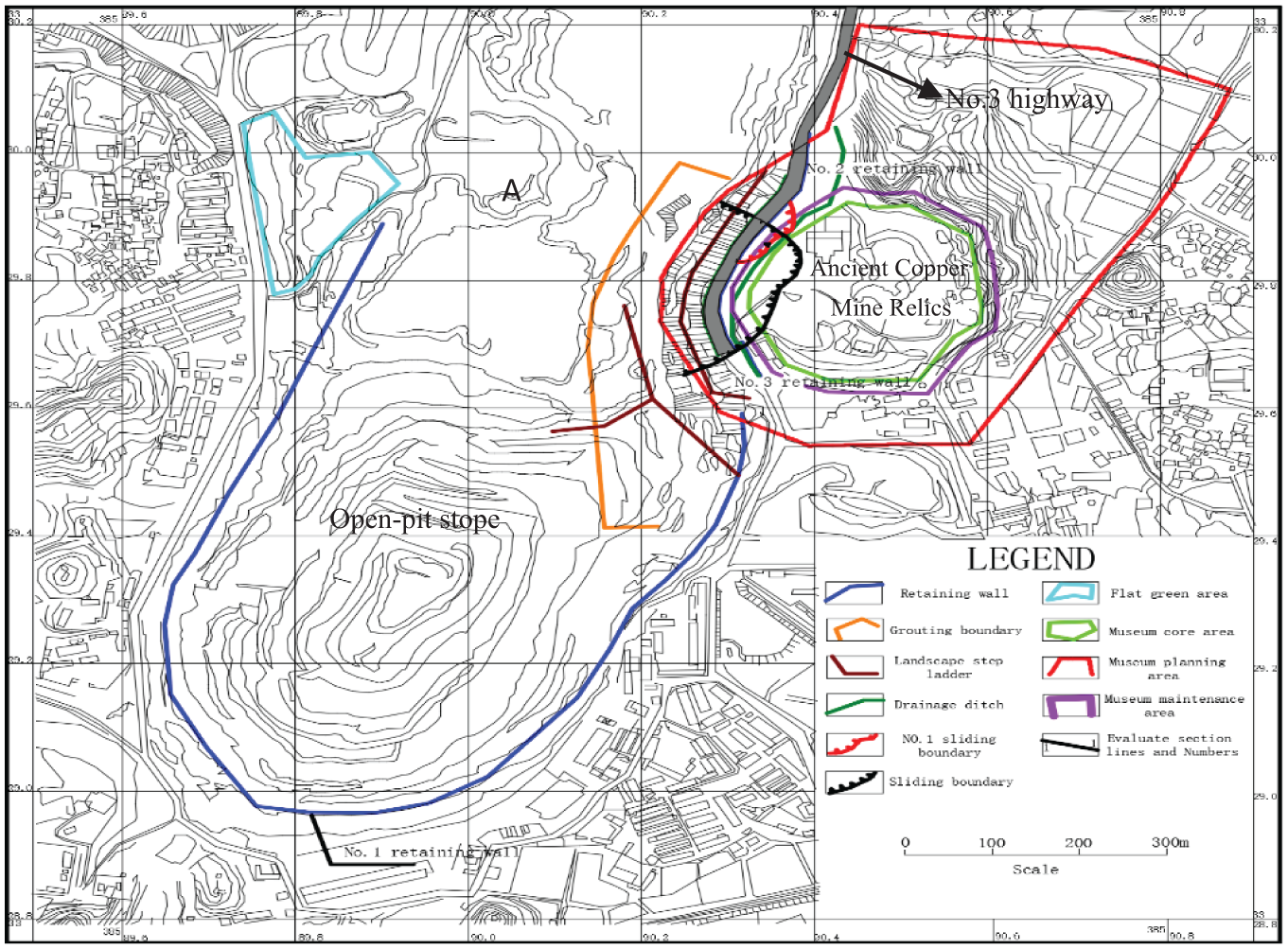
Study area in the Tonglushan ancient copper mine relics.
Hydrogeological conditions
The Tonglushan mine area has a typical northern subtropical climate. Precipitation, the main source of underground water, has an annual mean level of 1387.24 mm. The marble water body is the main recharge area of groundwater. The mining stratum for outcropping includes the Quaternary unconsolidated formation and magmatic rock in the Yanshan period. Water yield properties and permeability of the lacustrine deposit, alluviation clay, and sandy loam soil in the Quaternary layers are weak. The underlying sandy gravel stratum has a strong permeability and water yield properties. Magmatic rock and ore bodies developed along cracks around mineralization contact zones and construction fracture zones. Water yield properties and permeability of weathering fracture aquifers of the magmatic rock and ore bodies are stronger, and water yield properties and permeability of fracture aquifers of the magmatic rock and ore bodies are weak. The marble water body is the main aquifer in the mining area which provides priority to the karst cave and corrosion development. The granodiorite-porphyry outside the ore body can be regarded as an aquiclude.
Distribution and treatment of potential unstable slopes
After prolonged mining activities, a typical high steep slope formed on the east slope of the north open pit (the west side of the ancient copper mine relics). This slope has a height of 63.4–91.1 m, a width around 335 m, and a gradient of about 56°. The bedrock of the slope is weak-weathered granodiorite-porphyry with a higher strength, and the slope top is the Quaternary casing soil or tailings backfilling having good water permeability and poor stability. Landslide movement of the slope can therefore readily occur with the contact surface under unceasing permeation action of rainfall or surface water. According to exploration data of the site field survey on the ancient copper mine relics, the unstable slopes in the relic zones are mainly located around No. 3 highway. These are displayed as two landslides, one being new (No. 2 landslide) and the other being old (No. 1 landslide). The landslide deformation area is nearly 5000 m2.
No. 1 landslide body (old landslide outside the fence of the ancient copper mine relics) is located on the east slope of the No. 3 highway. This is located 10 m away from the museum fence of the ancient copper mine relics, with a slope angle of 40°. No. 2 landslide body (the east slope of the north open-pit mine) is located on the high east slope of the north open-pit mine, also located adjacent to the No. 3 highway (Figure 2). The No.3 highway is built to facilitate staff to arrive at the site, and the end of No.3 highway is the relic museum. The main entrance of the relic museum is on the other side of the relic museum, and the main entrance is more than 150 m from the slope of the stope. According to statistics, the daily traffic volume of No. 3 highway is about 15 vehicles, thus the traffic influence of No.3 highway on the stability of the study site can be basically ignored.

Distribution map of dangerous slopes surrounding the ancient copper mine relics (west side).
Due to mining activities, a lack of detection equipment in the goafs, and atmospheric rainfall, the slope of the ancient copper mine relics is still exposed to adverse effects. During phase I of the 2010 treatment project, the slope of the ancient copper mine was latticed for anchor bolts and slope protection, and the filling grouting project in the goafs was completed to reinforce the stability of the slope. In addition, the design project of treatment measures also enhanced deformation monitoring of the slope (Figure 3).

Site protection and monitoring measures of the relic museum: (a) external deformation monitoring facility and (b) reinforcement measures for the west slope.
Since 2012, influenced by mining activities and rainfall, internal and external cracks of the ancient copper mine relic museum have become more serious, with a continued developing and extending trend (Figure 4(a)). The retaining wall near the No. 3 highway and latticed girder in the east reinforcement area of the north open-pit mine was damaged (Figure 4(b)), indicating deformation of the west slope is still ongoing.

Distribution characteristics of internal and external local cracks in the relic museum: (a) Wall cracks in the northwest corner of the relic museum and (b) Local deformation damage in areas of reinforcement.
Thus, the high slope of the open-pit mine around the relics and mine blasting methods has influenced the slopes of the relics, although the original treatment measures have had a certain protective effect. However, the slopes in this area will become deformed under internal and external force, thus urgent action is needed to evaluate slope stability, undertake risk monitoring, and enable early warning.
Failure mechanism analysis of slope deformation
Influential factors affecting slope deformation
By observing the surface deformation configuration of the Tonglushan ancient copper mine relics, common points were identified for crack opening and surface subsidence, the degree of which varied. The extent of deformation gradually weakened from near slopes to far slopes, indicating that the slopes in this area are transforming from a “tight type” to a “compact type,” and that they are becoming deeper as they get closer to the slope edge. At the same time, they are gradually extending from the surface layer to the goaf. A number of factors have resulted in the deformation of the west slope of the Tonglushan ancient copper mine relics.13–16 Factors include the condition of the slope, long-term external vibration force, slope top pile-loading, and rainfall. Deficiency of the slope condition is the main factor affecting slope stability.
Deficiency of the slope condition
Deficiency of the slope condition mainly results from artificial mining. After mining activities for many years, a typical high steep slope formed to the east of the west open pit. Due to excavation, relaxation, unloading of the east slope in open-pit mines, and continuous adjustment of the slope stress, cracks which were almost parallel to slope trends were generated. These can readily create landslides in the induced function of external and internal adverse conditions. In addition, a large area of the goafs in front of the slope was formed due to prolonged underground mining, even if goaf filling was undertaken. However, it is now impossible to recover to the original stress status by filling as the stability of the high steep slope has been affected. When open-pit mines are stripped layer by layer from the top to the bottom, the transversal support gradually disappears, and slope unloading will occur. This will result in the lateral expansion of slopes, as well as cracking and subsidence of the trailing edge.
Long-term blasting vibration
The main source of vibrations in this area is due to explosive blasting, a common excavation method for open-pit mines. This method has resulted in the tipping point of the mining area to be near to the slopes of the copper mine relics. Slope surface soil becomes dense during vibrations, and the height and width of the slopes continually adjust. The deformation process of the slopes under blasting vibration is mainly expressed as subsidence, and then expansion on both sides, trailing edge cracking, and finally deformation destruction of the slopes. Long-term blasting results in the gradual loss of underground water and subsidence of the relic pits. Under long-term vibration action, the rock high-dip crack will be slack and expanded, thus underground water will permeate into the underground deep goafs along high-dip cracks. Based on the field monitoring data measured by vibration measurer, the maximum peak vibration velocity in relics museum aroused by “explosive blasting” mining reaches to 1.25 cm/s, which exceeds the allowable safety range of Safety Regulations for Blasting GB6722-2014.
Slope top pile-loading
Dead rocks and slag are present on the slope top, these sediments having been piled in the upward side of the slopes for a considerable amount of time. Stress change inside the slopes will therefore be transformed, thus increasing the bearing capacity of the slopes, and causing a further outward expansion. However, compared with the huge slope dead weight, the increased load is extremely limited. Top pile-loading on a slope however is not the main reason affecting landslides.
Influence of rainfall
Water will reduce slope rock strength, as well as reducing the sliding resistance force on the landslide surface. Previous investigations have shown that destruction and sliding for the majority of slope rocks are related to water effects.17–19 Due to frequent rainstorms, summer rainfall concentrates in the Tonglushan ancient copper mine. The upper mine district is constitutive of intense weathering diorite porphyry having lower relative intensity and poor stability. As rainfall occurs continuously, significant volumes of water will permeate into the soil layer, thereby weakening the soil shear strength. For a rock slope, when the rock or its weak intercalation has stronger hydrophily, disintegration and argillization phenomenon will readily occur. Rock strength will reduce and slope stability will then be affected. These occurrences are due to the existence of water-soluble minerals, the damaged structure of the rocks after long-term soaking, and the rocks undergoing several drying and wetting cycles.
Process analysis and development trend of slope deformation
The west slope deformation process of the Tonglushan ancient copper mine relics includes two significant stages. (1) Unloading and expansion—this early stage reflects underground collapse which results in the slope dead weight subsiding and lateral expansion. This stage is mainly controlled by rock tensile strength. (2) Shear sliding—this later stage occurs when the slope expands to a certain degree. Underground collapse filling results in densification, and subsidence and expansion begin to slow down. Tension will start to transform into shear stress, and the sliding surface will be searched. During this stage, rock shear strength plays a key role.
Under the influence of the rock’s own weight actions and the goaf, the back tension cracks of slopes increase and continually develop in deep slopes. The internal shear surface of slopes will continue to expand, local cut-through surfaces will gradually form, and cut-through shear sliding surfaces are finally formed. Accordingly, the front cut occurs to the slope front edge, the landslide starts to accelerate deformation, and tension or subsidence occurs to the rear edge cracks, resulting in damage. The accelerated deformation of the slopes will lead to mitigation. Finally, internal slope stress will reach a state of secondary balance and the affected slope region will become stable.
According to the slope evolution model, the slopes in the ancient copper mine relic museums are in the on-going accelerating deformation stage, which is the tension stage. The rear slope edge has cracks and subsidence, and the cracks of subsidence zones are located in slope edges. Due to the transverse girder support action reserved in mining, cracks have not yet run through the slope toe. The subsidence zones will gradually converge northward to the front courtyard of the relic museums. Due to being blocked by underground hard rocks, cracks will develop in an eastward direction, and the left-moving pinniform cracks will detour northward. After passing around hard rock bodies, cracks will develop in the southwest direction of the relic museums. Because there is a platform support downward in the eastern slope of the mining area, the cracks in the right edge have not yet run through the low slopes, but the road outside the fence of the relics has wispy cracks. With the effect of external conditions on the slopes, the slopes in relic areas will evolve from the tension stage to final large-scale landslides.
Stability evaluation of the current conditions in the relic area
Selection of calculation parameters
Selection of evaluation sections
In order to reflect the stability status of the east slope to the north of the open-pit mines, spatial relation with the ancient copper mine relics was used according to previous slope design data and previous studies incorporating the surrounding geological environment. This evaluation of the slope stability included seven new evaluation profiles (Figure 5). During stability evaluation and sensitivity analysis, reinforcement force, rainfall, earthquakes, and lithology are taken into consideration.

Profile distribution map for the slope stability evaluation profiles of the relics.
Parameter selection of rock and soil mass hydraulics
Rock strength is the ultimate stress when a rock breaks down under external force, and it is one of the main properties of rock mechanics. 20 Selection of calculation parameters for stability evaluation and sensitivity analysis was based on actual geological conditions with destruction modes in the evaluation areas. In 2015, the engineering geological survey was carried out by the State Key Laboratory for Geomechanics and Deep Underground Engineering (Beijing), The Slope Stability Evaluation and Monitoring and Early Warning Plan of No. VII Ore of Tonglushan Ancient Copper Mine in Daye City is formulated. The field direct shear test and field deformation test of a rock mass were conducted in 2015; comparing with Phase I Construction Design Plan of Geological Environment Governance Project for Hubei Daye Tonglushan Iron Mines (2010) and related documents, 10 the material characterizations are synthetically determined, which included cohesion force, internal friction angle, elastic modulus, and Poisson’s ratio. The selected parameters are shown in Table 1.
Mechanical parameters for rock and soil mass structural surfaces.
Calculation conditions
The sliding mode of a slope mainly depends on the rock mass structure, lithology, and rock mass stress state. Analysis of the rock slope destruction mode follows the rock mass control principle. By combining the conditions of the high east slope of the Tonglushan mine, the instability mode of the east slope in the north open pits is shown to have an arc sliding surface with vertical cracks. By studying the stability of mixing slopes in the rock and soil mass using the limit equilibrium method, it is important to confirm the potential slope sliding surface. To verify slope stability, we used GeoStudio software, and the confirmation for the potential sliding surface was obtained using an automatic search of procedures according to the slope sliding mode. Three types of conditions were established by considering the slope reinforcement force, underground water level features, earthquakes, and rainfall. The conditions were as follows: natural state + reinforcement conditions, natural state + reinforcement conditions + rainfall conditions (coupling condition), and natural state + earthquake conditions. Numeric values for the three conditions were also calculated.
The slopes of the Tonglushan ancient relics are mostly classified as rocky slopes, and they are significantly influenced by groundwater and blasting vibrations. The stability safety factor selected for our study mainly referred to the “Design code for engineered slopes in water resources and hydropower projects (SL 386-2007).” According to the specifications and field engineering geological conditions in the mining area, the allowable safety factor value of the slope was selected as 1.2, thus ensuring slope safety for the ancient relics.
Stability analysis of all conditions for slopes
By considering the distribution situation of lithology for all sections, we analyzed slope stability for seven selected sections. Figure 6 shows the geometrical shapes of all evaluation sections.
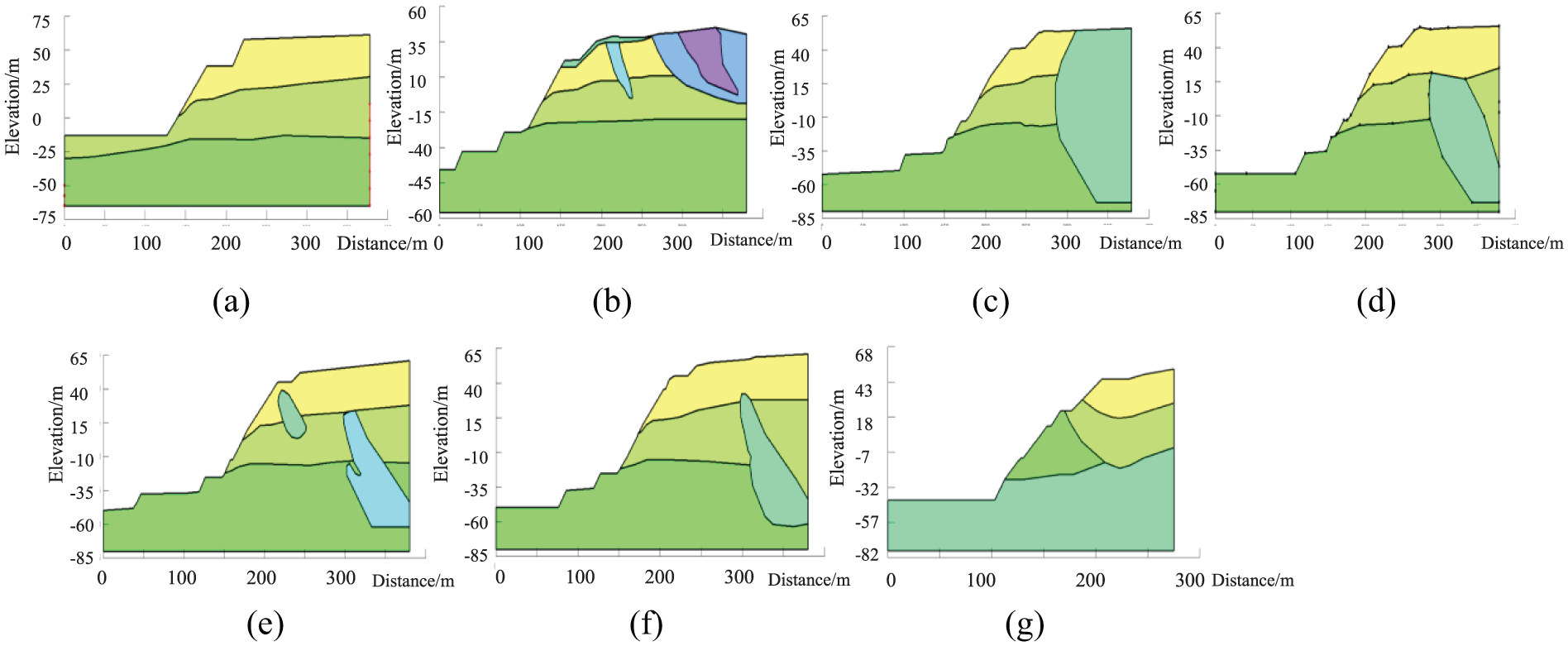
Calculation sections for slope stability evaluation for the current relic areas: (a) 1-1 calculation section, (b) 2-2 calculation section, (c) 3-3 calculation section, (d) 4-4 calculation section, (e) 5-5 calculation section, (f) 6-6 calculation section, and (g) 7-7 calculation section.
Stability evaluation on the current situation—reinforcement condition
In combination with the existing reinforcement arrangement condition of anchor bolts in the relics, the limit equilibrium calculation was undertaken for all sections in the research area under the consideration of reinforcement conditions. Slope section stability calculations are shown in Figure 7. In the stability evaluation on the current situation, the cutting-in and cutting-out methods were used to examine the potential sliding surface position.

Calculation sections for slope stability evaluation: (a) 1-1 section stability result, (b) 2-2 section stability result, (c) 3-3 section stability result, (d) 4-4 section stability, (e) 5-5 section stability result, (f) 6-6 section stability result, and (g) 7-7 section stability result.
By using GeoStudio software on the basis of the Morgenstern–Price method, slope stabilities for the seven selected areas in the ancient copper mine relic area were calculated. Slope stability calculation results of all sections of the relics with current reinforcement conditions are shown in Table 2.
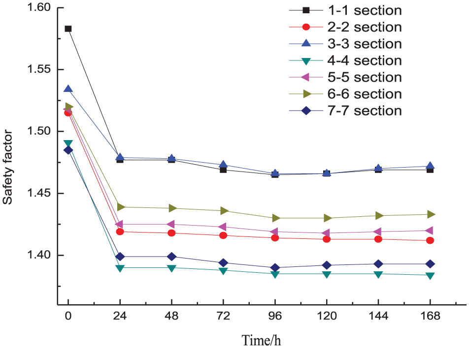
Safety factors for all slopes under reinforcement conditions.

Results for reinforcement conditions (Table 2) show that the safety factor (Fs) in section 1-1 was the greatest (1.583) and Fs for sections 4-4 and 7-7 was the smallest (1.491 and 1.485, respectively). All slope safety factors were much larger than allowable values [ΔFs] = 1.2 provided in the standards. 21 This finding shows that, with existing reinforcement conditions, slopes in the ancient copper mine relic areas are stable. Early stage governance work has increased slope stability, and Fs is marginally smaller in comparison with slopes in sections 4-4 and 7-7. Field investigations of the slopes revealed that some parts of the anchor bolt heads in the slope bottom sections of 4-4 and 7-7 were damaged and that the lattice girders were fractured. In addition, due to the influence of mining activities and rainfall, surface deformation and cracks are continuously and slowly developing, thus resulting in Fs of slopes in these sections being smaller.
Stability evaluation on the current situation—coupling conditions
To study the influence of rainfall and reinforcement conditions on the stable state of high slopes in the ancient copper mine relics, coupling condition calculations for the seven selected slope sections were undertaken. On the basis of the original models, we examined the comprehensive influence of rainfall and anchor bolt reinforcement factors on slope stability. By applying the finite element analysis procedure, SEEP/W, in the two-dimensional seepage of GeoStudio, we also calculated saturated–unsaturated seepage in the stable state and under transient conditions for slopes in the study area. These analyses enabled the effect of single rainfall events on slope stability to be examined.
Results from Daye meteorology and hydrology statistical analysis show that annual mean rainfall is 1387.24 mm and daily maximum rainfall is 204.7 mm. According to the standard scale of rainfall stipulated by the Chinese meteorological department, rainfall intensity in the research area attained extraordinary rainstorm levels, thus the rock slope runoff coefficient of 0.75 (the coefficient ranged from 0.5 to 0.9) was used to analyze the influence of rainfall infiltration on slope stability. In consideration of the Daye meteorology and hydrology statistical analysis, as well as the rock slope runoff coefficient, this calculation used 200 mm/d as the study sample. Rainfall duration was 24 h, and slope stability analysis within 144 h during and after rainfall was calculated for the seven calculation sections. Pore water pressure refers to the pressure of groundwater in the rocks which acts between particles or pores. Pore pressure conditions were measured using an in-situ pore pressure gauge. The permeability parameter was also called hydraulic conductivity. In isotropic media, this is defined as the unit flow under the unit hydraulic gradient, indicating the difficulty of a fluid to pass through the pore framework. The permeability parameters were synthetically determined using a field pumping test and an engineering analogy method; the permeability parameters of the rock mass are shown in Table 3.
Permeability parameters of the rock mass.

Each permeability parameter equation for the rock mass layers was obtained by adopting the Fredlund and Xing method on the basis of saturation permeability parameters and soil–water characteristic curves. Due to the steep gradient of the goaf on the east slopes, the calculated rainfall boundary was the area above No. 3 highway. Calculation results for section 1-1 are used as an example (Figure 8).

Calculation result for the 1-1 slope rainfall and reinforcement coupling in the relic area.
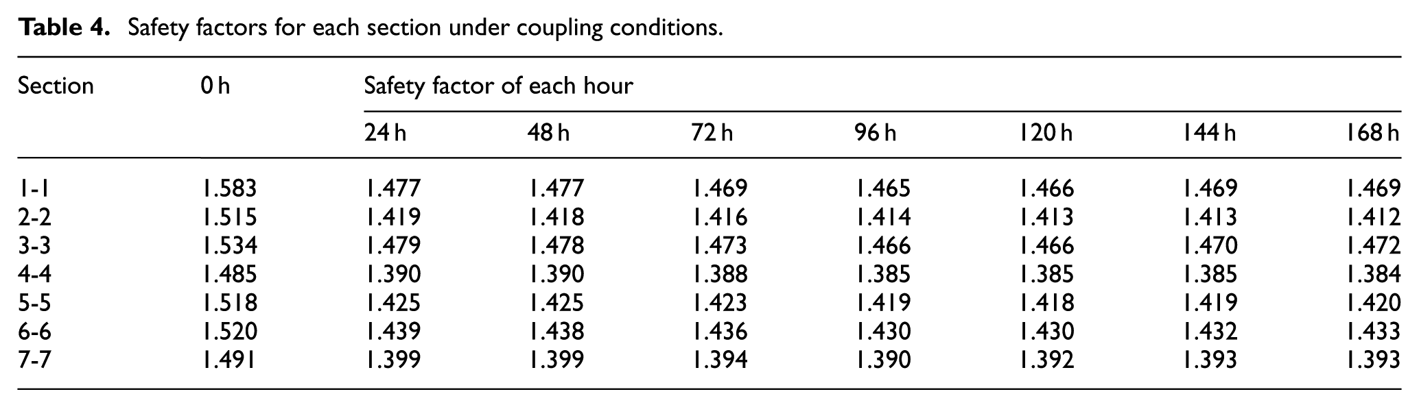
As the daily maximum rainfall in the research area is relatively high, and slope drainage is slow, simulation of slope stability was analyzed based on an undrained slope to ensure slope safety. Rainfall was calculated as having infiltrated into the interior of the slope. Under conditions, each slope section safety factor in the ancient copper mine relics was calculated (Table 4). Change rules of Fs in each section are shown in Figure 9.
Safety factors for each section under coupling conditions.
Safety factor change rules for slope sections under coupling conditions.
Results for the seven selected slopes in the coupling conditions (Table 4) showed that after 144 h, Fs for each slope was still greater than the allowable Fs value [ΔFs] of 1.2. This indicates that each slope at this time was still in a stable status; however, Fs for slopes 4-4 and 7-7 was relatively small.
After rainfall for 24 h, slopes in each section recorded a sharp decline in their Fs (Figure 9). This result indicates that rainfall infiltration has a significant influence on slope stability, and that the degree of influence for infiltration on the stability of the sections differed. After rainfall for 24 h, the safety factor for each slope section changed from having an initial reduction to increasing later. The Fs in section 1-1 recorded a sharp decline while in the other sections, Fs recorded different degrees of decline. After rainfall had ceased, the degree of decline for Fs between each section recorded a step-down pattern. After this, increasing trends were recorded.
Stability evaluation on the current situation—earthquake conditions
Natural and artificial earthquakes influence slope stability. Previous studies have shown that, when the slope is about 100 m high, blasting vibrations can significantly influence slope stability. 13 Due to these effects, we took the blasting influence coefficient as stability analysis. When the slope was higher than 100 m, natural earthquakes had a greater influence on the whole slope. For slopes >100 m, we therefore took the natural earthquake influence coefficient as the stability analysis according to the slope characteristics of the ancient relics. Tonglushan mines are located in a region classified as “Degree 7” for earthquake intensity, and the design basic earthquake peak accelerated speed is 0.05. In the stability calculation, we used the QUAKE/W finite element method to calculate and conduct Newmark deformation analysis (Figure 10) for the time–travel curve of accelerated speeds.

Time–travel curve of accelerated speeds.
First, we calculated the initial stress state of the models, and then calculated the dynamic response of the slopes. During the dynamic response analysis, we mainly considered the influence of the transversal earthquake wave on the computer models, thus the constraints on both sides were set as the vertical constraints. By using QUAKE/W modules, we calculated the stability of the seven slope sections in the ancient copper mine relic area. By taking section 1-1 as an example, the slope under earthquake conditions at two moments in time under dynamic stress in the slopes can be seen to undergo thermal agitation (Figure 11). The safety factor of slopes in Figure 11(a) show a decline, and the safety factor of slopes in Figure 11(b) show an increase. General analysis of earthquake conditions was recorded using this analysis at each interval step (taken as 0.02 s). Therefore, for a 10-s vibration, there are a total of 500 interval steps.

Deformation trend diagram of 1-1 slope under earthquake conditions: (a) Left vibration deformation and (b) Right vibration deformation.
The SLPOE/W procedures were adopted to calculate Fs for 50 saved interval steps, and we took the time-dependent Fs curve for three slope sections as an example (Figure 12). Slope Fs in some moments instantaneously fell below 1.0, and in consideration of the larger safety factor fluctuation of earthquake vibration, it is hard to judge the stability status of these slopes.

Safety factor vs time for three slope sections under earthquake conditions: (a) 1-1 section, (b) 2-2 section, and (c) 3-3 section.
Stability calculations for the slope sections under earthquake conditions are shown in Table 5. With the onset of an earthquake, the action time of the earthquake acceleration speed is short, and the slope safety factor recorded a sharp change around the static safety factor. Fs can drop instantaneously to below 1.0. However, the slope will not always completely collapse. Thus, under earthquake conditions, slope stability cannot be solely decided using safety factors.
Safety factors for each slope section under earthquake conditions.

To examine the complete collapse of slopes under earthquake conditions, we examined slope displacement during vibrations. According to slope displacement, the final stability status of a slope can be evaluated. Under earthquake action, deformation of each slope changed over time (Figure 13 shows the change rules). By combining safety factors of all sections after an earthquake event of 10 s, we identified the most dangerous position of the high slopes in the ancient copper mine relic area to be located on slope 7-7. This slope had the largest deformation value of around 50 cm.

Deformation vs time for all slope sections during an earthquake.
According to our analysis under heavy rainfall conditions, the existing reinforcement project can maintain slope stability in the study area. However, slope stability will sharply decline in the event of an earthquake, thus the influence of mining blasting activities on slope stability needs to be comprehensively analyzed. Currently, surface deformation and cracks in the reinforcement areas of the relics have become more and more serious. As the cracks have cut-through and ductile features, the safety and stability of the ancient copper mine relics are threatened. To protect these relics and to lower the influence of blasting vibration on the relics and the stability of the surrounding slopes, mechanical gun hammer techniques to strip the rock have been implemented in the north open pit instead of mining using explosives. However, as monitoring devices are not located in this area, the influence of these mining techniques on the relics and the stability of the surrounding slopes cannot be evaluated. It is therefore important to establish a monitoring and warning system to evaluate the slope stability surrounding the ancient copper mine relics.
A sliding force remote monitoring and warning system
Principle and system components
Early monitoring of the slope in the vicinity of the relics is predominantly to monitor for displacement and cracks. However, displacement and cracks are only the essential conditions for landslides, and they are not the sufficient conditions. It is difficult to accurately predict landslides using monitoring techniques. Monitoring to protect the relics must use forecasting monitoring functions to guarantee the stability in the relic areas. “Look-ahead shear sliding force” refers to shear sliding force changes before sliding that can be regarded as the essential condition for forecasting landslides. We can forecast landslides occurring using real-time monitoring over predicting sliding forces. By introducing findings by He Manchao, using a sliding force remote monitoring and warning system on the basis of constant resistance and large deformation (CRLD) anchor bolts, it is possible to conduct real-time monitoring over evolution characteristics for the slope sliding force. This will enable the change from phenomenon monitoring to nature monitoring, and guarantee future warnings for slope instability in the relic area.
Composition of indoor and outdoor monitoring devices
According to the monitoring principle of sliding forces and the working principle of CRLD bolts,22–26 we developed a landslide monitoring and warning system on the basis of sliding force changes (Figure 14).
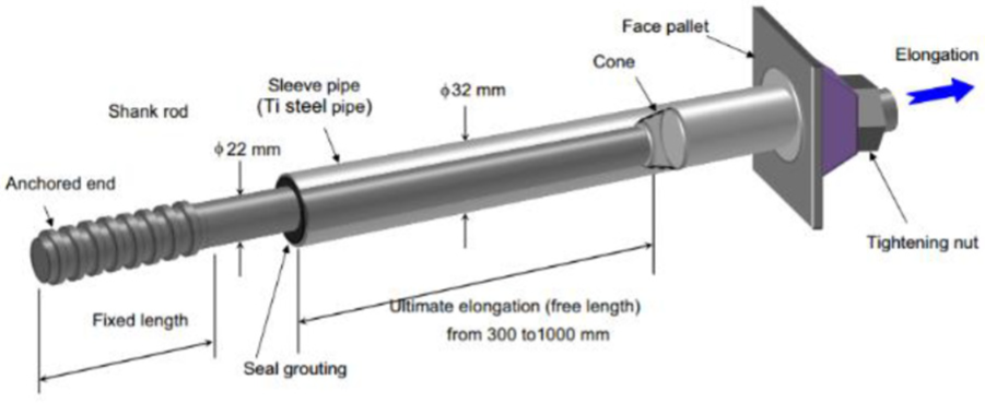
Schematic diagram of the constant resistance and large deformation (CRLD) anchor bolts.
This system is composed of indoor and in-situ devices. The indoor monitoring device includes a data receiving-processing-analysis system, monitoring PT target area 3 S map, three-dimensional (3D) monitoring project image search system, and aid analysis software. The in-situ monitoring device is composed of Beidou satellite receiving equipment, data processing systems, and information display systems. The signal receiver is used for receiving the data signal of launching systems and transmitting the receiving signals to computers for analysis. This system allows continuous monitoring data of site monitoring points to be obtained.
Landslide monitoring and warning criteria
According to the landslide remote monitoring principle and indoor physical model experiment results, the Level 4 warning mode of landslides for the Tonglushan ancient copper mine relics was established, and four colors were set as per the hazard level of slopes. Red signified a sliding warning, orange signified a nearly sliding warning, yellow signified a secondary stable warning, and blue signified a stable warning. Table 6 shows the specific levels and warning criterion details.
Warning levels and warning criteria.
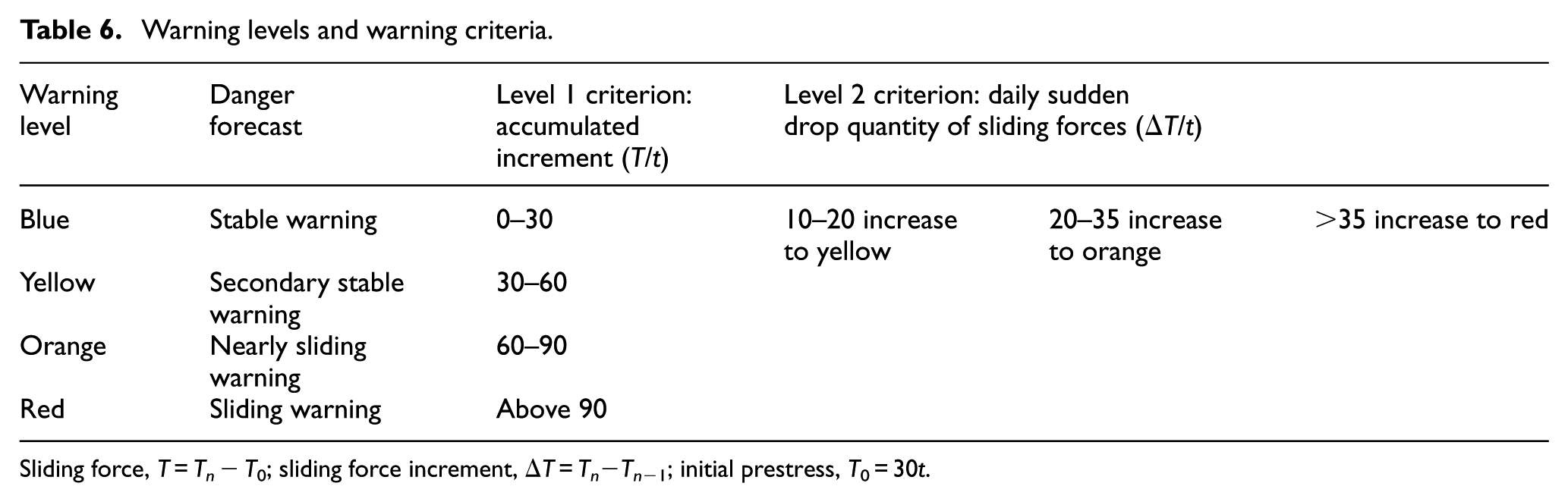
Sliding force, T = Tn − T0; sliding force increment, ΔT = Tn−Tn−1; initial prestress, T0 = 30t.
Monitoring point distribution of site sliding forces
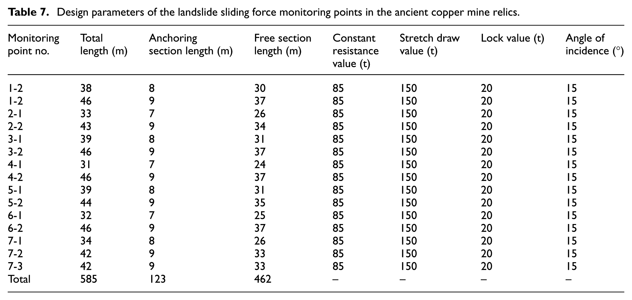
The monitoring areas were mainly focused on two potential landslide areas of wet slopes in the ancient copper mine relics: (1) the old landslide of the highway outside the relic fence (inner slope of No. 3 highway) and (2) the new landslide of the No. 3 highway (outer slope of No. 3 highway). Using the geology profile of actual section projects, under the premise of guaranteeing slope stability, economic parameters were used to conduct monitoring point design. A total of 15 sliding force remote monitoring points were designed according to 7 selected measurement lines (in a fan-shaped distribution with the relics as the center). The gap between measurement lines was 20 m, and the interval between monitoring points was 20 m. Figure 15 shows the horizontal distribution and section distribution features, and Table 7 shows the monitoring point parameters.

Distribution of dangerous slope sliding force monitoring points on the west side of the relics.
Design parameters of the landslide sliding force monitoring points in the ancient copper mine relics.
In relation with the geology profile in the Tonglushan ancient copper mine relics, the influence of mining under the landslide body to the landslide body needs to be considered, and scientific and economic arrangement methods were adopted. After consideration of these factors, the sliding force remote monitoring points above the landslide body were set up (Figure 16 shows the site construction process).

Site construction process: (a) drilling and bolt installation process and (b) the installation of the Beidou satellite communication system.
Monitoring results and analysis
On 10 May 2016, 15 sets of sliding force monitoring and warning systems were initiated. Data recorded from these instruments are shown in Figure 17.

Sliding force monitoring curves: (a) No. 1 sliding force monitoring curve of landslide body monitoring points and (b) No. 2 sliding force monitoring curve of landslide body monitoring points.
Results from the monitoring curve show a smooth and steady environment; sudden increases or decreases were not recorded (Figure 17). According to a field investigation, the west slopes of the relics did not show any deformation, indicating that the application of “mechanical gun” rather than “explosive blasting” mining techniques effectively reduced the influence of mining disturbance on the stability of the relics. However, due to the combined disturbance influence of underground mining and west hanging wall ore exploitation below the relics, and the local climate, the slope environment is complicated. It is therefore necessary to undertake real-time monitoring on the west slopes to guarantee the safety and stability of these slopes and the relics in this area.
Conclusion
Analysis of slope stability in the Tonglushan ancient copper mine relics showed that
Observations of surface deformation configuration in the study site revealed that crack opening and surface subsidence were common features. The degree of crack opening and the extent of surface subsidence however varied. The extent of deformation gradually weakens from the near to far slopes, indicating that the slopes in this area are transforming from the tight type to the compact type. Cracks are penetrating deeper into the soil and gradually extending from the surface layer to the goaf.
A number of factors result in deformation of the west slope. These include the weak conditions of the slope, long-term external force vibration, slope top pile-loading, and rainfall. By using GeoStudio software to simulate three types of conditions on the relic slopes, we found that in the reinforcement conditions, the safety factor for section 1-1 was at the maximum (1.583). Results also showed that slope safety factors for all slopes were larger than permissible values [ΔFs] = 1.2. This indicates that original treatment measures suitably controlled the slope changes. With sustained rainfall, slope safety factors had different levels of decline. Section 4-4 had the lowest safety factor (1.384), and each slope section was still in stable states. When earthquake vibrations affected the slopes, slope stability for each section sharply declined. The combination of safety factors of all sections after the earthquake effect of 10 s indicated that the most dangerous position of the high slopes in the ancient copper mine relic areas was located on 7-7 slopes, with the largest deformation value of around 50 cm. The influence of mining blasting activities therefore on slope stability requires further investigation.
Early monitoring over the slope of the relics is mainly directed at slope displacement and cracks. Accurate forecasts of landslides using phenomenon monitoring is difficult, especially for monitoring over the national protection relics. Predictive monitoring is therefore an important function. By using a sliding force remote monitoring and warning system, monitoring curves indicated that the application of “mechanical gun” instead of “explosive blasting” mining techniques in the open-pit mines effectively reduces the influence of mining disturbances on the stability of the relics. This method provides the opportunity to effectively control deformation of the relics.
Footnotes
Handling Editor: MA Hariri-Ardebili
Declaration of conflicting interests
The author(s) declared no potential conflicts of interest with respect to the research, authorship, and/or publication of this article.
Funding
The author(s) disclosed receipt of the following financial support for the research, authorship, and/or publication of this article: This work was supported by the National Natural Science Foundation of China (grant no: 41502323).