
Abstract
A review of the historical ecology literature led us to the realization that there was an important gap in terms of recognized methodological procedures and techniques. Contributions along these lines are sparse. However, some publications (book chapters and papers), some of them case studies, contain methodological material of great interest. Therefore, all these materials needed to be gathered together and put in a historical ecology methodological context. With this in mind, this article focuses on the methods employed to date in historical ecology when working with qualitative and graphic materials. In addition, it incorporates an exploration of the links between these methods and those used in general in qualitative research. Historical ecology requires source criticism methods (a source critical approach which offers guidelines for both source and source reliability assessment) and time line–based methods for landscape change. Some of the techniques used in historical ecology, but not originate from it, are presented (historical maps, photointerpretation, repeat photography, and oral history). The methodological links between historical ecology and qualitative research are then explored, and, finally, a method for text analysis (thematic networks) is presented.
Keywords
Introduction
Historical ecology can be defined as any research that examines the changes in and interactions among ecosystem patterns and processes through time: the history of an ecosystem. Such changes more often than not include anthropogenic effects, but these do not always need to be explicitly considered. (Rhemtulla & Mladenoff, 2007)
With respect to historical ecology, this article gathers together the qualitative methods that have been used as well as the techniques employed when working with qualitative materials, which include historical written documents (archive material), historical maps, aerial photographs, pictures, oral sources, and texts. Furthermore, the article offers guidelines for researchers doing historical ecology under a qualitative framework by providing them with a background on historical ecology and qualitative research, which focuses on aspects of analytical procedures common to both, as well as an overview of the topic.
Historical Ecology—Notes About Its Methods
Historical ecology is a scientific field, which is currently developing (Szabó, 2015). While there have been several contributions to it from the theoretical point of view (Balée, 2006; Beller et al., 2017; Bürgi & Gimmi, 2007;), methods and techniques have received less attention. Only a few studies have considered them and then only partially (e.g., Bürgi & Russell, 2001; Edmonds, 2005; Forman & Russell, 1983; Huntington, 2000; Pooley, 2018; Santana-Cordero, Monteiro-Quintana, & Hernández-Calvento, 2014; Vellend, Brown, Kharouba, McCune, & Myers-Smith, 2013).
An important feature of historical ecology methods is the spatiotemporal component, something essential when working on a territory and its historical processes. “Historical” here refers not merely to the society but to the cultural component of the landscape and the imprint that people leave in the land. Other central, integrative concepts are traditional ecological knowledge (TEK) and local ecological knowledge (LEK), which connect society and land, human knowledge, and landscape dynamics.
Although the previous concepts are relatively well known in historical ecology, the lack of a “methodological culture” triggers gaps when analyzing sources. For example, in historical ecology, a lack of awareness of qualitative methods and techniques can lead authors to omit the important question of “how” in the methodological sections of their publications (Attride-Stirling, 2001). This lack of “qualitative culture” has caused many researchers to include biased information in their works and fail to take proper advantage of the qualitative sources because the guidelines for doing so are not as visible as, for example, in quantitative procedures. Furthermore, monographs on qualitative methods (books; Bryman, 2012; Flick, 2009; Glaser & Strauss, 1967) have usually been oriented toward other disciplines such as sociology, health investigations, and so forth.
Historical Ecology Methods
Some historical ecologists have especially been concerned with the quality of the information of the historical sources, and the methodological issues tackled by historical ecologists have been along these lines within a qualitative approach. This has been named the “source critical approach” in historical ecology (Bürgi & Gimmi, 2007).
Source Critical Approach
“A source critical approach, commonly used in historical sciences, has to be applied and careful testing and evaluating, if possible by comparison of different source types or statistical methods, is crucial” (Bürgi, Straub, Gimmi, & Salzmann, 2010). A source critical approach is also fundamental due to the characteristics of the historical sources (Rymer, 1979). In this regard, historical sources often provide only partial information on the object of study, so it is necessary to consult as many sources as possible (documentary and oral) to complete this information. Moreover, the researcher has to keep in mind who produced the documents and his or her objective in doing so, as sometimes the author may offer a biased view depending on the particular objective. This can happen, for example, with travelers’/explorers’ written accounts and historical map technical skills. Even if we assume that the source material is fragmented, dispersed, and conditioned or “contaminated” by the human hand (Santana-Cordero et al., 2014), measures can still be adopted to evaluate this material.
Source Assessment Guidelines
Several questions and procedures have been described in historical ecology to deal with the question of source assessment. Rymer (1979) focused her questions on the writer, that is, the producer of the sources that are to be used. However, Forman and Russell (1983) also considered the kind of source (first- or second-hand observation) and the historical context in which it was created.
Rymer (1979) proposed the following set of questions: How far was the writer interested in recording real events? Did the writer live close in time and space to the events described? Were the events recorded as they happened or long after? Did the writer have first-hand access to oral or written reports and, if so, were they transmitted correctly? Would the writer have benefited by presenting incorrect information? Do the different sources agree with one another?
Forman and Russell (1983) concentrate on four stages in the analysis of historical sources, especially for texts: First- or second-hand observation: Did the author of a statement personally make the observation reported, or was it learned second-hand from the actual observer, or is it third-hand information, even written long after the event? Purpose or possible bias of the statement: Did the author of the statement have a special interest or bias, which may have colored the statement? Author’s knowledge of the subject: Did the author have the necessary ecological and taxonomic knowledge to make the statement? Context of the statement: What was the broader historical and ecological context in which the statement was made?
Carefully answering these questions can help us to use the sources correctly.
Source Reliability Guidelines
A semi-qualitative method to determine source reliability was proposed by Santana-Cordero, Monteiro-Quintana, and Hernández-Calvento (2014). The method focuses on source characteristics and their potential contributions to the study in question.
In this method, a series of variables are considered and assessed: (1) the type of source, (2) the detail level and/or resolution of the information provided, and (3) the analyses that can be applied. Each variable is comprised of different categories. In the case of source type, there are two categories: direct and indirect. “Direct” refers to those sources which provide information that has not been interpreted (e.g., street-level and aerial photographs), while “indirect” refers to documents which contain information that has been previously interpreted (e.g., bibliographic sources, historical written documents, explorers’/travelers’ written accounts, oral sources, historical cartography). A value of 1 is assigned to direct sources and 0.5 to indirect ones. For the second variable, the detail level/resolution determines the extent and quality of the information that can be extracted from the source. The categories of this variable are “low”, “medium,” and “high”, and their values 0.25, 0.5, and 1, respectively. To assign a source to one of these categories, attention is paid to the “scale” in which the information is expressed and/or the level of detail. For example, a source can be assigned to a particular category depending on whether it provides information at regional, insular, or local (municipal) scale. For the final variable, three distinct analyses are considered: (i) analogy, (ii) contrast of information between two or more sources, and (iii) the possibility of spatial information extraction. Analogy refers to the possibility of establishing similarities and differences between, for example, the study area and other similar areas. Contrast of information involves verifying the data provided by a source through its comparison with other sources of the same or different nature. Spatial information extraction refers to the capacity of the sources to show or describe, for example, the location of land elements. The latter analysis is particularly interesting for historical cartography and aerial and street-level photography. If an analysis is feasible, a value of 0.1 is given, so that the maximum score that each source can acquire for this variable is 0.3. An overall reliability value can then be calculated for each source, within the range 0.75–2.3, which is then standardized on a 0–1 scale and gives a reliability-level value (rlv) to each source. The standardization procedure involves dividing the sum of the values of all categories (Σcv) by 2.3 to give the rlv (Σcv/2.3 = rlv). Finally, the rlv is divided into three classifications: low (<0.33), medium (0.33–0.66), and high (>0.66). Table 1 shows the assessment criteria and the values awarded in each category (Santana-Cordero et al., 2014; Table 1). For further information about the application of this method, see Santana-Cordero et al. (2014).
Criteria for Evaluating the Reliability of Historical Sources.

This method has clear potential for further development.
Time Line–Based Methods for Landscape Change
Bürgi and Russell (2001) defined two methods for studying landscape change from the point of view of ecology. These can be considered and used in historical ecology, since they fit the basic requirements of spatiotemporal changes in a landscape/ecosystem. Although usage of these methods is not restricted to qualitative materials, they constitute good procedures for their analysis.
Specification of human impact: Two time lines are required in this method, a time line of changes in environmental features and a time line of changing human activities (both time lines with the same time frame). By comparing these two time lines, we can find “interactions between society and nature” that help to explain the changes. In these cases, human changes tend to trigger environmental changes, sometimes rapid ones as in arid aeolian sedimentary systems. Normally, however, a time lag is produced between the human action and its manifestation in the environment (Figure 1).
Double comparative studies: Two similar study sites are required to apply this method. An analysis is made for each site (1 and 2) using the same timescale of the environmental characteristics (A and B for Sites 1 and 2, respectively) and of the human activities that have taken place on them (C and D for Sites 1 and 2, respectively). The objective is to study the responses of the Environments A and B after the Human Activities C and D, respectively, have taken place. Then, the evolution of the environmental variables/features of interest is registered between two (or more) points in time. Human activities and natural disturbances with potential impact are evaluated. A and B will have different responses and will be transformed into E and F, respectively.

Specification of human impact. (A) Changes in environmental features and (B) changing human activity. Source: From Bürgi and Russell (2001).
Techniques Used in Historical Ecology
We searched existing historical ecology literature to identify various techniques that are suitable for application to historical sources. Here, we present four of them, in relation to historical maps (extraction and comparison of land elements), aerial photos/orthophotos (photointerpretation), pictures (repeat photography), and oral history (oral sources).
Historical maps
The simple techniques described below will help the researcher to analyze one or more historical maps of a site. GIS software and drawing software tools as QGIS or Inkscape are required. The type of software required will depend on geometric issues of the maps. For example, whether the base of a historical map can be overlaid onto the contemporary satellite image (GIS can be used) or not (drawing software required). For further information, see the Discussion section in Santana-Cordero, Monteiro-Quintana, and Hernández-Calvento (2016).
The first technique consists of extracting the information of interest, for example, land covers, from a scanned historic map, thus eliminating other elements that are of no interest for the particular purpose in question and that can cause noise. An example of this technique can be found in Santana-Cordero et al. (2016), in which a drawing software was used. The second technique involves extracting the elements of interest from several historical maps of a same site (different years) and overlaying them. This is shown in Santana-Cordero et al. (2014), in an analysis of the evolution of the main dunes of the former Guanarteme dune field (Canary Islands, Spain) during the 18th century (Figure 2). While the first technique allows work to be carried out only with the elements of interest showing us their evolution, this second technique allows comparisons to be made of the studied elements. In addition, work with GIS allows to make spatial measures and analyses.
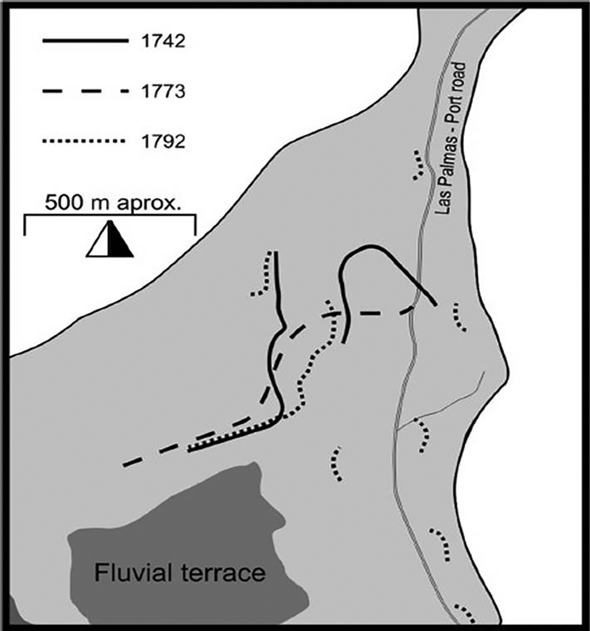
Main dunes in the Guanarteme dune field during the 18th century. Source: From Santana-Cordero, Monteiro-Quintana, and Hernández-Calvento (2014).
Historical maps and their analysis have been employed in case studies. For example, Santana-Cordero et al. (2016) used 11 historical maps to reconstruct the land-use history of the former Guanarteme dune field (Gran Canaria, Spain) between 1834 and 2012. Haase, Walz, Neubert, and Rosenberg (2007) used a set of historical maps, supported by GIS, to study methodological aspects related to working with historical maps and their application in Saxony (Germany). A study carried out by Levin, Kark, and Galilee (2010) about settlement patterns in southern Palestine should also be mentioned, since it uses a number of historical maps and discusses important technical issues of historical cartography. Finally, Velli, Pirola, and Ferrari (2018) used two vegetation maps (1959 and 1975) and one land-use map (2009) to study landscape changes in the last 60 years in the Southern Central Alps (Italy). This was done with GIS. For further information on this technique, see Rumsey and Williams (2002).
Photointerpretation
Aerial photographs and orthophotos are images that show a piece of land from an elevated point, such as from a camera installed in an aircraft or a high point in the land (e.g., a mountain). There are two types of aerial photograph: vertical and oblique. Vertical aerial photographs are available from the early 1930s in some cases (Morgan, Gergel, & Coops, 2010). They constitute a very powerful source for the study of changes in land cover and other biophysical elements.
The photointerpretation procedure for the analysis of aerial photographs requires an examination of the eight following characteristics: tone or color, size, shape, texture, pattern, shadow, site, and context (Morgan et al., 2010).
In Figure 3, Grossinger, Striplen, Askevold, Brewster, and Beller (2007) examine land changes in an anthropogenic landscape in Cottonwood Lake, from an agricultural landscape to an urban one. Note the evolution of the forestry area (riparian ecosystem) in the more recent aerial photograph. Other examples can be found in a review by Fensham and Fairfax (2002) of the application of aerial photographs in studies of vegetation evolution in which they also provide interesting data about the Australian vegetation history. Also, using aerial photographs, Garbarino et al. (2013) considered forest structure, anthropogenic influences, land uses, and topography to study the driving factors behind the dynamics of the European larch (Larix decidua Mill).

Cottonwood Lake in 1939 (A) and 2005 (B). See changes in land covers and in riparian characteristics. Based on Grossinger, Striplen, Askevold, Brewster, and Beller (2007).
Repeat photography
Repeat photography constitutes a simple and inexpensive technique, which is highly regarded by researchers (Reithmaier, 2005). Essentially, a comparison is made between two pictures of the same place, which have been taken at two different times but from the same exact point (location) and with the exact same perspective. As commented on by Bürgi, Straub, Gimmi, and Salzmann (2010), repeat photography provides information on small-scale changes and changes in the appearance of landscapes. The identification of landscape changes, as in landforms, vegetation, and land uses is the main aim of this technique (Rohde & Hoffman, 2012). These changes become apparent when observing two images from different years of the same landscape.
Although few changes can be seen in Figure 4, the vegetation and topography can be easily identified and changes to them easily detected.

Example of repeat photography. Source: From Rohde and Hoffman (2012).
Repeat photography has partially constituted the basis for studies in landscape change, such as those conducted in Namaqualand and Namibia (Hoffman & Rhode, 2007; Rohde & Hoffman, 2012, respectively), South Africa. The aims of these analyses were to study the environmental history from 2000 years BP to the 18th century (the case of Namaqualand) and to examine the vegetation change from 1876 to current times (the case of Namibia) in response to local and global drivers. In their study, Garcia-Lozano, Pintó, and Daunis-i-Estadella (2018) included a set of repeat photographs, selected to analyze land changes in several beach-dune systems along the Catalonian shoreline (Spain). Finally, Meyer and Youngs (2018) highlighted the value of repeat photography in their study on historical landscape change in Yellowstone National Park (United States).
Oral history
Oral sources are generated by interviewing people that know or have known a place or phenomenon in which the researcher is interested. This source is thematically adapted from the design stage of a research project and is often linked to historical ecology. The generation of oral sources can result in a significant contribution to the overall research project that a researcher is working on. The recording of oral testimony, subsequently preserved in oral history documents, is a basic technique used to obtain LEK and TEK (Huntington, 2000), particularly important sources for many historical ecology studies. The interview structure design can vary depending on various factors including, for example, whether the interview is to be held with an expert or a layperson.
Many studies have used oral sources in historical ecology. As well as using other sources, Trueman, Hobbs, and Van Niel (2013) reconstructed preanthropogenic impact (pre-1960) vegetation in the Galapagos Islands based on oral testimonies. Bürgi, Gimmi, and Stuber (2013) studied forest use in five regions of the Swiss Alps based on 56 interviews and evaluated the procedure used for its application in other forest areas. In a study by Morris and Rowe (2014), oral sources formed part of a project to record vegetation changes in the Great Basin (United States), which were once climate-driven but which in the last 150 years have been primarily caused by differing human land use. In another case study, research was conducted into how people had transformed, managed, and conserved the Araucaria forests of Southern Brazil, making use of oral history interviews to access LEK (Machado Mello & Peroni, 2015). Finally, Munoz, Mladenoff, Schoeder, and Williams (2014) explored the land uses associated with prehistoric and early historical Native American societies, for which interviews were conducted.
Methodological and Source Links Between Historical Ecology and Qualitative Research
There are at least three strong links between historical ecology and qualitative research in terms of methods and sources: (1) historical ecologists use qualitative data (texts, interviews, observations) in their studies, (2) historical ecology and qualitative research use multiple data types and source types in their studies, and (3) historical ecology and qualitative research use interviews as one of their main techniques.
Qualitative research can be defined as “a research strategy that usually emphasizes words rather than quantification in the collection and analysis of data” (Bryman, 2012). The most obvious link is the use of qualitative data in historical ecological studies. Old texts and observations, which can be found in archives, and interviews with (usually) elderly people about the past features of an ecosystem or landscape, constitute the basis of a number of studies (Gimmi & Bürgi, 2007; Santana-Cordero, Monteiro-Quintana, & Hernández-Calvento, 2016). However, in historical ecology and in qualitative research literature, there are no explicitly stated links between these two types of research.
Historical ecology and qualitative research use multiple types of data and types sources in their studies. Qualitative data constitute nonnumerical information obtained from both verbal and nonverbal sources. The first general source is based on language content (e.g., recordings, interviews) and the second on visual content (e.g., video, photos), also treated here as graphic material (Schreiber, 2008).
The sources used in historical ecology can be split into two types of evidence: (a) documentary/cultural evidence and (b) scientific/biological evidence (Egan & Howell, 2005a, 2005b; Rymer, 1979). According to Rymer (1979), in the field of historical ecology, documentary evidence is “any evidence that was recorded before accurate scientific observations were made in a particular area, and that pertain to any aspect of the environment.” It constitutes a qualitative source with archival data (e.g., historical written documents, historical maps), paintings, sketches, and observations (e.g., travelers’/explorers’ written accounts) comprising the most commonly used and important examples of documentary evidence. The qualitative data (sometimes described as categorical data) that can be obtained from these sources can also be statistically treated. In short, historical ecology documentary/cultural evidence is, basically, qualitative data. This does not mean that only historical sources (before scientific observations were made) are qualitative. On the contrary, current written documents (descriptions, scientific literature, pictures), interviews (that become texts after transcription tasks), and field observations can form part of the set of qualitative sources useful for historical ecology.
Historical ecology and qualitative research use interviews as one of their main sources. The acquired and passed-down knowledge and the memories that people have of their environment can constitute a vital resource for the creation of new sources that can be developed using various techniques (Huntington, 2000). For example, TEK and LEK have played an important role in many fields, including environmental and sustainable development management decision-making (Armstrong et al., 2017). They refer to the knowledge that people have about the environment where they are living or have lived in other times. They differ, according to Robertson and McGee (2003), in that LEK is the knowledge of a particular group of people about local ecosystems, while TEK also requires a historical and cultural connection with the local ecosystem. Huntington (2000) suggests the following techniques to extract TEK/LEK information: semi-directive interviews, questionnaires, analytical workshops, and collaborative fieldwork.
In qualitative as opposed to quantitative research, the methods are applied throughout the investigation rather than in one specific stage of the process. This is especially significant for questions of data collection and sample size, in which the overall process marks the limits.
Text Analysis: A Qualitative Method Applicable to Historical Ecology
Texts are a very important source of data but, to date and as far as we are aware, no precise details are available about the procedures required for their analysis in historical ecology. This can be an obstacle for a research project given that text analysis is one of the main tasks that historical ecologists need to master for their investigations. Below, we explain the thematic networks method, which has been proposed as a tool for qualitative research (Attride-Stirling, 2001), and use the example of a short historical text to illustrate its utility.
Thematic Networks
This method is a way to identify, organize, and analyze the themes that constitute a text. Through its development, a network is established of basic themes, organizing themes and global themes (classes of themes), which is then used to shed light on the text being analyzed.
A basic theme can be defined as a lowest order premise found in a particular text. Once we have a number of basic themes, they can be split into more abstract principles (organizing themes) by going through them and extracting the common idea that they share. At this point, we repeat the process carried out for the basic themes on the organizing themes and thus determine the global theme/s, which represent the highest level of abstraction.
The main stages of the method are (a) reduction or breakdown of text, (b) exploration of text, and (c) integration of exploration. Within these, there are six steps. This method assumes that the design, fieldwork or data collection, and (when required) transcription, have already been carried out.
Step 1: Coding the material
The principal aim in this step is to reduce the data. This is achieved by the following: Devising a coding framework: The coding framework provides a way of labeling fragments or even individual words in the text. Various coding strategies are described in Corbin and Strauss (1990) and Flick (2009). The basic aim of the coding process is to reduce the vast amount of information the researcher is working with when handling a text (Bryman, 2012). It is important that the coding framework has explicit boundaries. Dissecting the text using the coding framework: The text is broken down into fragments and each selected fragment should meet one or more of the criteria determined for the particular object of analysis. Once these lower order categories are established, they can be divided into more general and abstract categories. Following the open coding process (Corbin & Strauss, 1990), events/actions/interactions can be compared with others for similarities and differences. Questioning and constant comparisons of the events/actions/interactions identified are required in the coding process to avoid subjectivity and bias.
Step 2: Identifying themes
In this step, the researcher extracts common or significant themes from the coded text fragments. A rereading of the text can help identify underlying patterns and structures. The selected themes can then be further refined into themes that are “(i) specific enough to be discrete (non-repetitive), and (ii) broad enough to encapsulate a set of ideas contained in numerous text segments” (Attride-Stirling, 2001).
Step 3: Constructing the networks
The task now is to group the basic themes by interrelating them where possible. Between 5 and 15 basic themes are recommended for each thematic network. Each group of basic themes is placed under one organizing theme, which will be labeled according to the larger and/or shared issues in the different groups which now comprise the organizing theme. The main claim/s, proposition/s, argument/s, assertion/s, or assumption/s that the organizing themes are about should then be extracted and grouped together under one or more global theme/s.
Once this has been done, the information gathered needs to be graphically displayed in a nonhierarchical, weblike representation. Each global theme will establish a thematic network. Now, the whole text should be reexamined and checked to ensure that (i) the themes, of all three levels, reflect the data and (ii) the data support the themes.
Step 4: Describing and exploring the thematic network
The actual analysis begins in this step, and from this point on it is necessary to work with each established thematic network separately. The researcher returns to the text and interprets it with the help of the networks: (a) describing the content of the network and (b) exploring the network, that is, exploring and uncovering underlying patterns. The text should be reread keeping in mind the basic, organizing, and global theme/s. This will take the researcher to a deeper level of analysis.
At this point, patterns of the text begin to emerge. Attention is focused on the organizing themes, analyzing them one by one, identifying each one’s most essential factors, and exploring the relationship between the concepts of a particular organizing theme and the global theme/s. In this way, meanings and underlying patterns emerge. The ideas/concepts are ordered by relevance (in terms of spatiotemporal dominance). Once the conclusions about one organizing theme have been reached, we can proceed to analyze the next one (of the same thematic network).
Step 5: Summarizing the thematic network
The main themes and patterns which have emerged from Step 4 and which characterize the network now need to be summarized. Finally, an all-encompassing term can be identified to define the thematic network.
Step 6: Interpreting patterns
To tackle this step, firstly, it is necessary to complete the analysis of all the thematic networks. Here, the aim is to extract (from the summaries of all the networks) the main themes, concepts, patterns, and structures and connect them with the research question(s) and the theoretical grounding of the investigation. At this point, the researcher returns to the research question with arguments based on the patterns uncovered in the text/s.
Deductions from all the network summaries and the relevant theories are taken together to explore themes, concepts, patterns, and structures.
An example—Analysis of the text “Los efectos de las olas” (1756)
To demonstrate this method, a short historical text is dissected and analyzed using the thematic network method. The text, Los efectos de las olas (The effects of waves), was previously used in a study by Anaya Hernández (2007). It is an official communication from the General Captain of the Canary Islands to the Spanish King about impact of the Lisbon tsunami of 1755 on the islands.
The following table shows the thematic network that was established for the text (Steps 1–3).
Description of the thematic network (Step 4)
In this analysis, a thematic network has been constructed. The global theme of “Lisbon tsunami 1755” encompasses four organizing themes: consequences, event characteristics, LEK contribution, and social response. There are nine basic themes in consequences, another nine in event characteristics, three in LEK contribution, and one in social response (Table 2).
Thematic Network Comprised of Basic Themes, Organizing Themes, and a Global Theme.

Note. The basic themes in this example correspond to sentences from the analyzed text. LEK = local ecological knowledge.
Analysis (Steps 4 and 5)
Tsunamis are extremely rare events in the East Atlantic coasts, people did not know what was happening, and the Canary Islands are secure when facing tsunamis, are the underlying ideas of the text. Consequences: Physical and social damage to the coastal area. Event characteristics: Origin in other place; and quasi-global influence as tsunamis have long-distance effects. LEK contribution: Ecosystem dynamics knowledge, transferred information from ecosystem to people, that is, tsunamis are ecosystem processes. Social response: Culture dependency and emergency situation management.
Next, the emerging ideas are exposed: The Lisbon tsunami had social and physical effects in Europe and mainland Spain. Although the Canary Islands were not prepared for such events, it barely affected their coasts anyway. The culture of the moment led people to pray to God to intervene and impede any catastrophic consequences for the islands. This shows that religion still held sway over scientific knowledge, which had not yet arrived to the islands. Summarizing idea: natural event.
It is not possible to carry out Step 6 in this example, because it is necessary to connect the result of the analysis with the research question(s), which has been not established here.
Outlook and Conclusions
Historical ecology and qualitative research have an obvious link that is clearly visible in many case studies. Although a series of source types may be used with different corresponding qualitative methodologies, normally, one source type and its corresponding methodology are more important and have more weight in the study than the rest.
All the methods presented in this article can be applied individually or in combination. In historical ecology, various methods and sources are generally used to obtain data (results) of different nature, for example, textual data, cartographic data, and so on. At this point, the concept of data integration emerges, which is currently a challenging issue, and each author (or group of authors) addresses it as best as they see fit.
Similarly, the question of oral source sample size has been a point of controversy. While Bryman (2012) and Malterud, Siersma, and Guassora (2016) suggested procedures where the number of interviews is not predefined, other authors considered that a predetermined number of interviews is necessary for a proper study to be carried out. Some authors have proposed 20–30 interviews as a prerequisite for an oral-based study, others 60–150, and even 28–31 (other authors cited by Bryman, 2012).
Another important issue concerns the characteristics of the historical sources. Vellend, Brown, Kharouba, McCune, and Myers-Smith (2013) explored the advantages, limitations, and solutions (overcoming limitations) for historical maps and historical photos (pictures and aerial photos). More specifically, Garcia-Lozano et al. (2018) described some of the limitations of aerial photographs and pictures: Long-distance views, often poorly conserved, and partial views that impede the proper identification of the elements of interest. All historical sources have to be carefully examined when working with them, because many factors mark the quality of the information that they provide (Russell, 1997).
Some opinions have emerged that argue for the invalidation of the use of a given historical source. For example, Reithmaier (2005) claimed that historical maps that are not proportional to reality are useless for comparison purposes with other existing maps. However, there should be no problem in comparing different maps, which have the same proportional errors if they were copied or adapted from the same base map. In addition, the spatial data of some maps could be used as valid thematic (nonspatial) data for the study in question.
“Historical ecologists do not analyze texts, they simply read them and extract ideas.” A comment like this might be considered uncomfortably close to the truth when one reviews the historical ecology literature and finds no explanation about text analysis methodology. After identifying this important gap, this article used one particular qualitative method (thematic network method) to illustrate how awareness of qualitative research can benefit historical ecology. Although clearly limited in extent, even this short example is able to convey the utility of a stronger theoretical foundation in the analysis of qualitative data in historical ecology.
Future efforts in the study of qualitative methods in historical ecology should be made by, at least, two ways. First, case studies using these methods have to be performed to test and assess their validity in the common practice. Second, theory-oriented studies concerning other qualitative methods (e.g., grounded theory) are needed to analyze in depth the potential of such methods in historical ecology.
Footnotes
Acknowledgments
Thanks are due to the Institute of Botany (Czech Academy of Sciences) for the 6-month postdoc contract to Aarón M. Santana at the Department of Vegetation Ecology (Brno, Czech Republic), the Universidad de Las Palmas de Gran Canaria for the current postdoc contract to Aarón M. Santana, and Steve Burns for his comments on the example given for thematic networks analysis. Finally, this article is a contribution of Project CSO2016-79673-R funded by the Government of Spain. This research was supported by long-term research development project no. RVO 67985939.
Declaration of Conflicting Interests
The author(s) declared no potential conflicts of interest with respect to the research, authorship, and/or publication of this article.
Funding
The author(s) disclosed receipt of the following financial support for the research, authorship, and/or publication of this article: Ministerio de Educación, Cultura y Deporte (Government of Spain; Grant No. CSO2016-79673-R) and Akademie Věd České Republiky (Government of the Czech Republic; Postdoc fellowship).