
Abstract
This study explores evidence-based urban planning (EBUP) within three secondary cities in the Global South—eThekwini, Khorog, and Bosaso—emphasizing public sector capacity to utilize data in urban management. Amidst the proliferation of data and advanced analytical tools, many local administrations struggle with effective data use due to limited resources, technology, and governance frameworks. This paper examines how urban planners mobilize, integrate, and apply data to create actionable evidence for city planning, considering the socio-political and technological landscapes that influence these processes. By analyzing qualitative data from interviews and case studies, this research highlights the challenges and potential of EBUP to address urban issues in data-scarce environments. The concept of good enough evidence is explored, advocating for practical, adaptable, and locally tailored planning efforts that prioritize immediate urban needs over exhaustive data collection. This approach seeks to balance ambition with practicality, offering a pragmatic pathway for cities facing constraints in resources and capabilities.
Keywords
Key Points for Practitioners
Considering how different cities mobilize and use data provides planners and policymakers with insights into how data can be better managed and utilized as knowledge to meet urban planning objectives effectively
Evidence can be assessed not just on accuracy or comprehensiveness but on its fitness for specific intended uses, users, and contexts.
Recognizing the acceptable boundaries of good enough planning practices is crucial for implementing realistic and effective planning strategies that are sensitive to the resource constraints and socio-economic conditions prevalent in developing contexts.
In many descriptions of the emerging smart, evidence-based approaches to urban management and planning (Engin et al., 2020; Jiang et al., 2019), a key promise is the capacity to provide maximally comprehensive data to base decision making, underpinning a rational approach to spatial transformation, service delivery and policy development (OECD, 2020). This data “deluge” (Kourtit et al., 2020) claims several benefits over traditional planning methods, such as greater geographic coverage, reduced data bias, enhanced accuracy and time efficiency (Marasinghe et al., 2024; Pereira et al., 2018). Consequently, many scholars and practitioners have highlighted the potential of new technologies to help developing countries overcome historical challenges (O’Clery et al., 2023), particularly regarding perceived data scarcity (Chirisa et al., 2024; Milan & Treré, 2020) while improving transparency and civic trust (Head, 2010).
However, this technological optimism brings the risk of overemphasizing the importance of data, leading to a race in increasing the levels and granularity to provide indisputable evidence to planning decisions (O’Clery et al., 2023). This push often occurs before understanding of the implications, limitations, and boundaries of the data collected, particularly in relation with capacity and resources of governance structures and the needs of society at large (Herrera & Kapur, 2007). Many of these local administrations continue to struggle with weak capacities to collect, manage, and effectively utilize data for evidence-based urban planning (EBUP) (Agyemang et al., 2024). In the absence of clear guidelines to distinguish between essential and non-essential datasets (Bali Swain & Yang-Wallentin, 2020; Son et al., 2023), prioritize key tasks, and deploy appropriate technologies (Pereira & Prokopiuk, 2024) these cities are often stuck in a cycle of inefficiency (Tan & Taeihagh, 2020). Further, without a clear understanding of short-term achievements versus long-term goals, and being realistic about the limited resources available, local governments in the Global South are placed in a precarious position, unable to effectively manage climate risks and respond to the challenges of rapid urbanization (Echendu & Okafor, 2021; Wiig & Silver, 2019). This situation prompts critical questions about what constitutes good enough evidence-based planning systems, that can meet urgent societal needs but are designed and implemented with local circumstances and tenures in mind, in contexts where funding, resources, equipment, and capacity are constrained.
Our study presents a comparative analysis of public sector capacity in three cities in the Global South - eThekwini (South Africa), Khorog (Tajikistan), and Bosaso (Somalia). It examines the obstacles and enablers of EBUP, by studying how data is mobilized to derive evidence and fed into urban planning exercises. Through this approach, our study seeks to explore what constitutes evidence in data poor environments, and how it is used throughout the planning process.
Our contribution is threefold. First, we chart how evidence is used as knowledge, identifying the generative mode of utilization alongside traditional instrumental, strategic and conceptual modes (McKenzie et al., 2014). This highlights how data resources are often gathered to create value beyond immediate purposes, creating spillover effects when governance structures allow for it. Second, we demonstrate the significance of mapping data flows within urban planning ecosystems to visualize bottlenecks and opportunities in diverse data environments (Bates et al., 2016; Kitchin et al., 2025). In doing this, we highlight how EBUP rarely follows the good data value cycle (Van Ooijen et al., 2019) but rather is subject to contextual adjustments that contribute to some level of good outcomes, although far from ideal. Third, we explore and refine the notion of good enough applied to evidence based planning (Gabrys et al., 2016; Kayanan et al., 2025), arguing that planning systems cannot aspire to perfection but must be assessed on their fitness for specific intended uses, users, and contexts. This approach advocates for practical, adaptable, and locally tailored planning efforts that prioritize immediate urban needs over exhaustive data collection.
Literature Review
Mobilizing Data as Evidence and Knowledge
Politicians, practitioners, and researchers alike have championed the efficacy of data-driven or evidence-based approaches (Head, 2008; OECD, 2019; Ubaldi, 2013). This trend has intensified with the pervasive digitalization and datafication of governance, particularly within planning practice (Kitchin et al., 2025).
According to the larger body of literature of evidence-based policy (Cairney, 2016; Parkhurst, 2017; Wastell, 2006), evidence should be derived from relevant scientific data and information to construct policy advice or evaluation, using various scientific tools and instruments (Ribeiro et al., 2019; Turnpenny et al., 2015). However, the mobilization of data into evidence doesn’t happen in a linear value chain but though a process characterized by feedback loops and ongoing iteration (Van Ooijen et al., 2019). Data informs decision-making processes, which reciprocally influence subsequent data production and collection strategies. Consequently, examining how knowledge circulates—how it is developed, mutated, and consolidated among actors (Borén & Schmitt, 2022) —throughout the data value cycle (Zheng & Pee, 2022) - can help in understanding how knowledge is turned into practice.
Figure 1 provides an illustration of such a (ideal) data value cycle, where data gets aggregated, analyzed, and synthesized (Sterner et al., 2020; Van Ooijen et al., 2019). Each level (rectangles) symbolizes a wide category of products or outcomes shared among practitioners, researchers, policymakers, and community members. Arrows linking levels illustrate data processes important for creating value throughout the levels (Klievink et al., 2018; Thabit et al., 2024). Data collection functionalities used on the primary level can include small-scale ubiquitous technologies such as sensors and large-scale systems such as satellite and airborne remote sensing systems, land survey technologies, geophysical and biophysical instruments, and technologies used in government surveys and business transactional systems (Bibri, 2018; Kitchin & Lauriault, 2015; Koeva et al., 2022). Intermediary levels technologies require the ability to integrate data from multiple and often disparate sources. A range of data access and processing technologies have emerged under the umbrella term of data platforms that can technically support in the integration of data collected from urban actors and communities into a knowledge base (Sinnott et al., 2015). From there, urban actors can conduct analyses and modeling, e.g., forecasts or scenarios; and further integrate these capabilities for integrated risk analysis (Mora et al., 2021) and finally use data as evidence in specific urban problems, policy decisions, or commercial applications (Nochta et al., 2021).
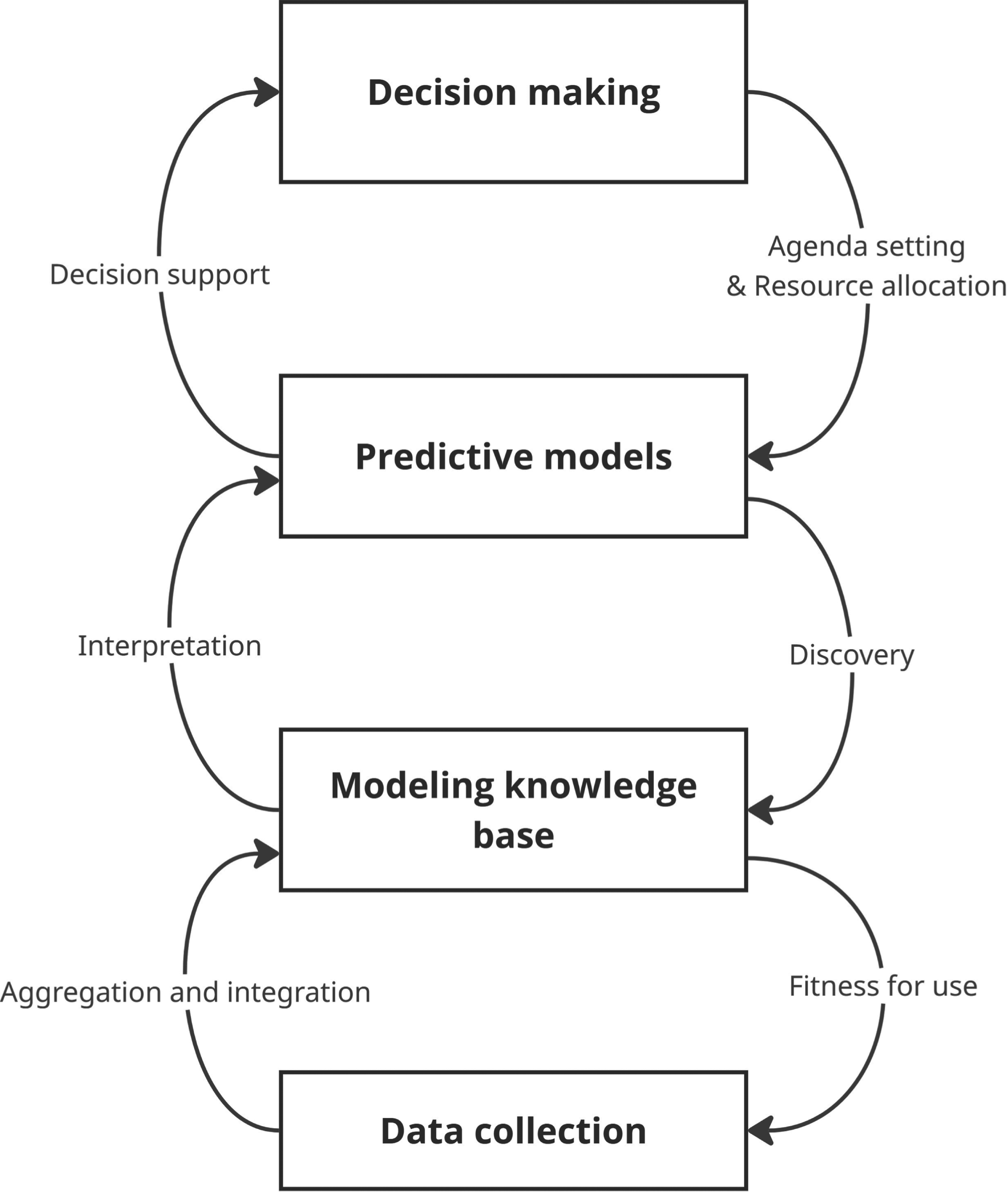
Ideal data value cycle - based on Sterner et al. (2020); Van Ooijen et al. (2019).
Each subsequent level enhances the data received from earlier levels by deepening analysis and synthesis, typically leading to a decrease in data volume as it moves from lower to higher levels within specific processing streams. – thus known methaphors of pyramids (Berkman, 2020) or funnels (Cambrosio et al., 2020).
However, literature, guidelines and tools also remark the importance of the reuse and repurpose of data and knowledge across various contexts, ranging from their initial applications to unforeseen uses in other contexts (Mora et al., 2025; Schaepman et al., 2022) and mergeable into cohesive information resource, generating greater value (Van Ooijen et al., 2019). This adaptability would allow for innovative applications within the same environment, such as predictive analytics, decision-support tools and decision making, and create spillover effects through new data resources (Zheng & Pee, 2022).
The cycle just described tracks the journey from handling raw, unstructured data to identifying complex relationships, thereby generating usable information and knowledge. While this knowledge forms the fundamental basis for taking action, its application in planning is not uniform; rather, it can be categorized into three distinct modes based on the specific aims and how clearly defined the information is (McKenzie et al., 2014). These uses can be instrumental, where data is transferred as knowledge directly from scientists to decision-makers, who base their visible decisions on technical reasons (Acuto et al., 2021; Davoudi, 2006b). In conceptual uses, knowledge enriches and expands understanding of topics, influencing how individuals think about policy issues (van Kerkhoff & Lebel, 2006). Through this engagement, decision-makers and stakeholders become aware of new challenges and potential solutions, gradually shaping their beliefs and values. This iterative process can redefine the policy agenda over time and may even change behaviors among individuals and organizations, potentially leading to policy shifts if external circumstances provide opportune moments. Additionally, evidence can be strategical in advocating for specific interventions, advance new policy proposals, or reinforce existing beliefs and values (Boswell, 2008).
This perspective highlights the varied nature of how evidence is utilized in planning, emphasizing that it cannot be separated from its institutional setting, broader societal influences, or existing power dynamics and norms (Ansell & Geyer, 2017; Krizek et al., 2009). Urban actors have to combine their data in ways that not only get individual datasets to travel from their sources to decision makers (Cronemberger & Gil-Garcia, 2024) but also ensure that these datasets integrate to form a trustworthy body of information (Sterner & Elliott, 2023). Constructing evidence require in fact assurances about quality and accuracy, but also legitimacy, accountability, sovereignty, privacy, licensing, and many other non-technical issues are necessary prerequisites to data use and reuse (Sheehan & Leonelli, 2025). As such, data used as evidence is the result of processes of interaction, dialogue, negotiation and decision-making among urban actors involved in the development of social norms and institutions (Rekola & Paloniemi, 2022; Rossi et al., 2025). This suggests that the meaning of evidence is rarely definitive (Davoudi, 2006a; Faludi & Waterhout, 2006), and as much social and political as technical in character (Nochta et al., 2021).
Good Enough Evidence
The varied modes of evidence utilization underscore that knowledge alone constitutes a necessary but insufficient basis for decision-making. In practice, only a fraction of available evidence is actually used (Choo, 2005), and action is often required before an evidence base is fully complete (Moser, 2013).
This discrepancy implies that the uneven adoption of evidence-based planning is not solely attributable to lack of capacity or will among organizations, practitioners, and decision-makers. Rather, it is equally driven by gaps in access to resources and insufficient institutional capacities to execute data processes.
Furthermore, digital systems are often introduced progressively, with varying specifications and standards (Datta & Hoefsloot, 2024). These systems frequently support divergent data models and are managed across siloed units with alternative priorities. This fragmentation hinders the data value cycle. This is particularly acute in the Global South, a context that struggles with systemic resource constraints and infrastructural deficits (Datta, 2018; Tonnarelli & Mora, 2024). Here, the challenge is compounded by acute data scarcity, where the absence of reliable baseline information often renders standard analytical tools ineffective (Milan & Treré, 2020). In these contexts rapid transformation dynamics and urbanization processes often transcend the capacity of evidence-based approaches to cope (Parnell & Pieterse, 2014).
Consequently, recent studies highlight the importance of evaluating the feasibility of technology based on the human, financial, and technical resources required for its deployment in specific contexts (Tonnarelli & Mora, 2025b). The principle of ‘fitness-for-use’ is employed across diverse disciplines to denote the degree to which a product, service, or system can adequately fulfill its intended function within a reasonable resource expense (Rijke et al., 2012; Tonnarelli & Mora, 2025b). Specifically, it assesses whether an organization can quickly and effectively achieve its objectives with its available resources, while also considering requirements for ongoing maintenance and potential future improvements.
A parallel can be drawn with the concept of “good enough governance” in international development studies. This framework recognizes that resources and political will are often limited, especially in fragile states, making the pursuit of perfection unrealistic (Grindle, 2004). Instead, it prioritizes addressing key governance challenges such as rule of law, effective public administration, inclusivity, transparency, and accountability, even if these elements are not fully developed (Grindle, 2007).
Along these lines, a good enough evidence-based planning system might not be the most rigorous, efficient or accurate in its operation, but could still be performing reasonably and sufficiently (Kayanan et al., 2025), by utilizing “good enough” processes, technologies and data (Bialski, 2024; Collins et al., 1994; Gabrys et al., 2016).
Given bureaucratic complexities, resource constraints and financial limitations inherent in urban governance, simply sustaining a functioning workflow is a significant accomplishment. Rather than chasing a perfect and encompassing knowledge, the goal is to build evidence that is effective enough to foster development and serve the public, tailored to the specific needs and constraints of the society or context (Saidi et al., 2024).
Leveraging on these concepts, in the next sections we will examine how the principles evidence-based planning are applied in concrete urban planning scenarios. By exploring the defined purposes of EBUP and the boundaries of acceptable evidence, this exploration aims to clarify what good enough truly entails in the context of urban planning and whom it ultimately serves.
Methodology
Case Studies
We used a qualitative approach to analyze the different declinations of EBUP in three secondary cities in developing countries and how these systems are evidence-based: eThekwini (South Africa), Khorog (Tajikistan), and Bosaso (Somalia).
In targeting our comparative case studies (Yin, 2018), we sought representing different level of development (least developed, lower-middle and middle income countries) that nonetheless have invested in capacity and technology to improve their urban planning systems. In all the cases, this shift was supported at different capacities by projects of the United Nations Human Settlements Programme (UN-Habitat), an agency that explicitly champions evidence-based planning as a cornerstone of sustainable urban governance.
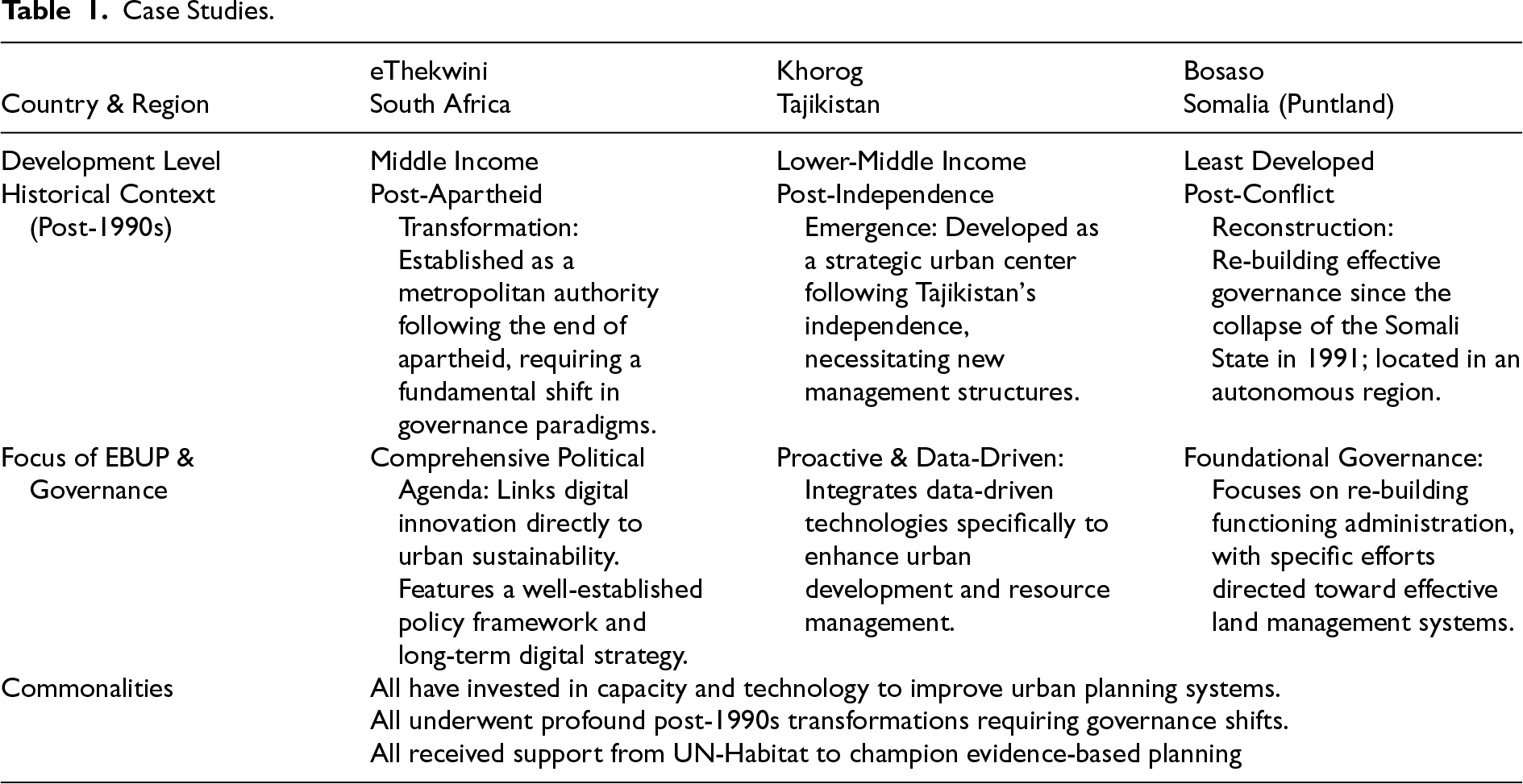
Beyond this institutional support, these contexts share a history of profound post-1990s transformation, which necessitated fundamental shifts in governance and planning paradigms. eThekwini is one of the metropolitan authorities established in the post-apartheid South Africa. Since its foundation, eThekwini has emphasized digital technology in its long-term development strategy (Odendaal, 2011), and has now developed a well-established policy that links digital innovation to a comprehensive political agenda for urban sustainability enhancement (Söderström et al., 2021; Tonnarelli & Mora, 2025b). Khorog, emerging as a strategic urban center in a newly independent Tajikistan (Dörre & Schütte, 2020), has adopted a proactive approach to urban planning by integrating data-driven technologies to enhance urban development and resource management (Hertlein, 2020; Middleton, 2016). Bosaso, in the autonomous region of Puntland, since the collapse of the Somali State in 1991 has been making efforts towards re-building an effective governance system, particularly in land management (Tonnarelli, 2024; Tonnarelli & Sophianos, 2025), and it is regarded as an example of functioning local administration within the region. Table 1 provides an overview of the case studies.
Data Collection
The data collection followed a phased approach. Semi-structured interviews were carried out with fourteen stakeholders focusing initially on eThekwini and Khorog. Interviewees included three distinct groups: (i) local representatives from the two cities, (ii) experts and practitioners from UN-Habitat, and (iii) external actors such as donors, financing institutions and private sector data providers. A snowball sampling method was used, with an entry point stakeholder from each group typically providing recommendations on other relevant interviewees.
The findings from this first round of interviews were presented and discussed in a focus group discussion involving interviewees from UN-Habitat, Khorog and eThekwini.
The feedback was used to develop an updated set of questions which was used in a new round of semi-structured interviews covering Bosaso. This covered thirteen stakeholders following the same group categories and sampling method applied in the first phase. See Annex A for a list of the interviews.
Data triangulation (Johansson, 2007) was carried on digital datasets and integrated analytical documents published by UN and government agencies and referenced in the interviews and documents.
As previous affiliates of UN-Habitat, the authors’ insider positionality (Bandauko, 2024) provided access to stakeholders and documents (Chavez, 2008). However, this presented the risk of several biases, including social desirability bias through responses aligned with institutional priorities (Schulz, 2020) and selection bias through network-based recruitment (Collier et al., 2004; Geddes, 1990). To mitigate this, we triangulated interviews with document reviews (Bell-Martin & Marston Jr, 2021) and enforced a rigorous coding protocol. The analysis involved multiple iterative cycles to systematically refine categories, ensuring that emerging themes were consistent and strictly grounded in the data rather than institutional assumptions.
Data Analysis
Interview transcripts and focus group discussion were analyzed using a thematic-coding approach (Gioia et al., 2012). An abductive method of analysis allowed the identification of codes and concepts, linking empirical data and dimensions of instrumental, conceptual and strategic evidence use.
The coding process was conducted in three key stages. Initially, one author identified the primary concepts through direct engagement with the data, which were subsequently reviewed and discussed with a second author. Finally, both authors held periodic discussions to refine the overall coding results and data structure (Skjott Linneberg & Korsgaard, 2019).
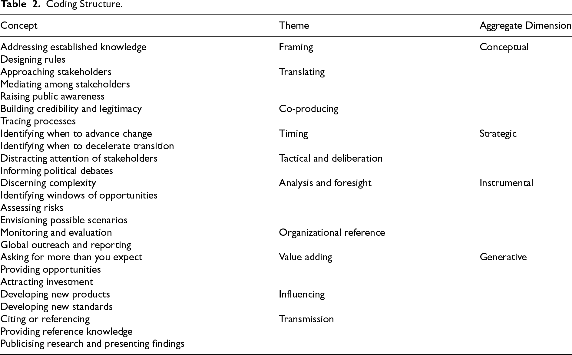
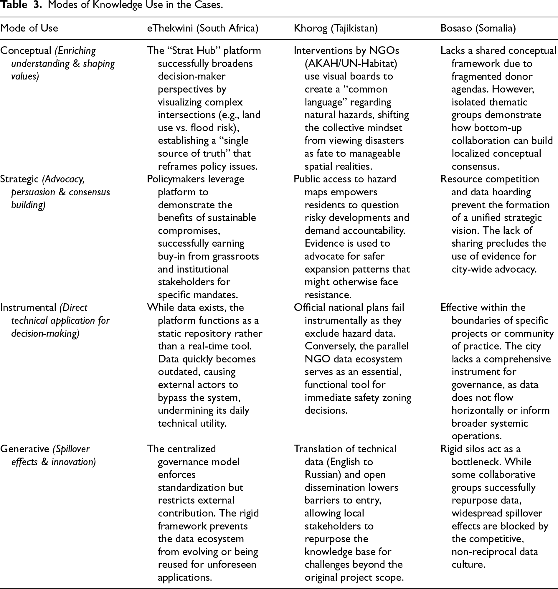
The information generated from this review is synthesized in the overall coding structure in Table 2. Annex B presents some of the most representative quotes extracted during the coding process. Additionally, the information extracted from interviews and document review was used to map data flows within urban planning ecosystems in each of the cities, based on the ideal data value cycle (Sterner et al., 2020; Van Ooijen et al., 2019) The results are also depicted in Figures 2, 3 and 4.
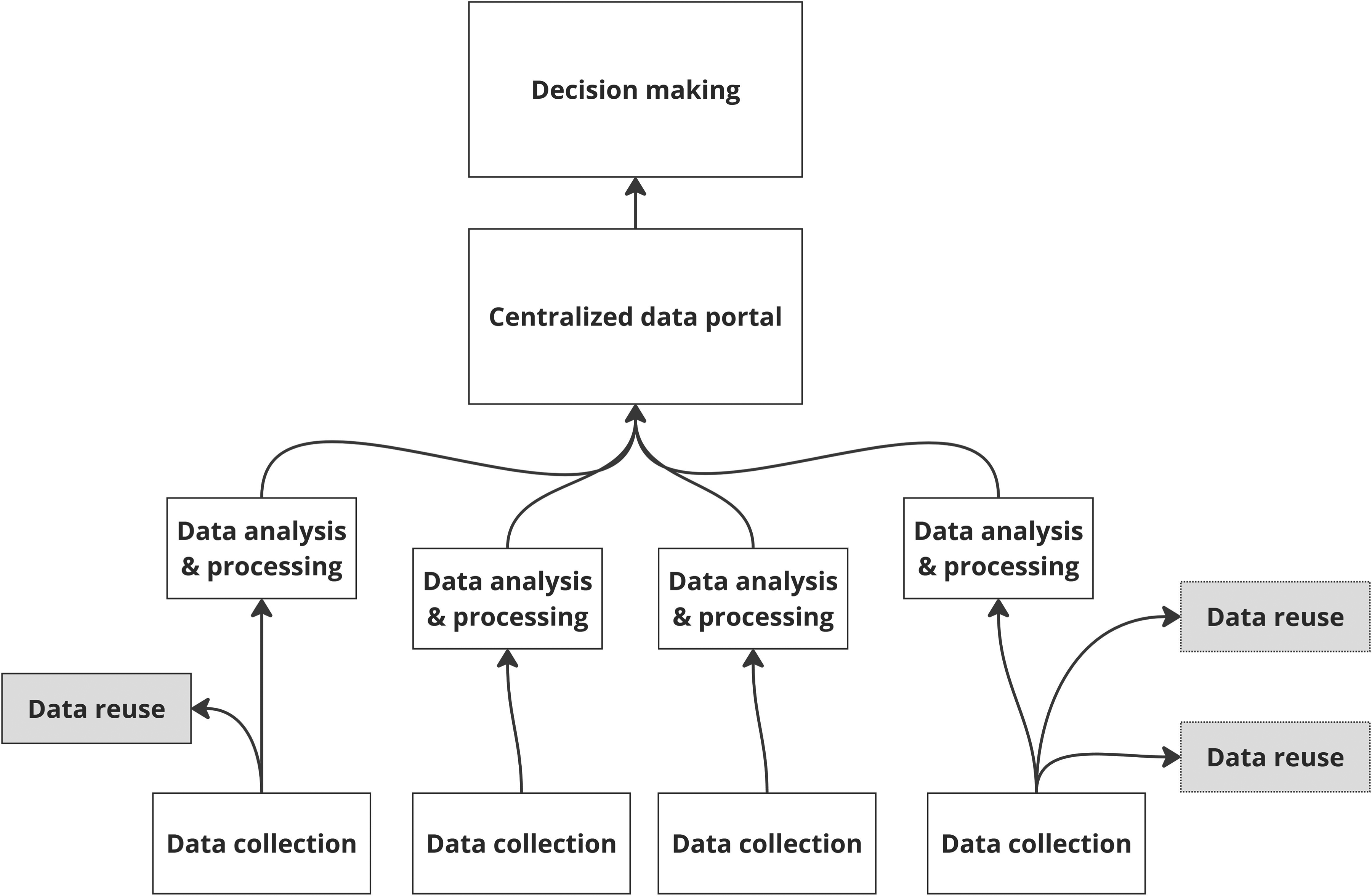
Data value cycle, eThewkini – grey rectangles denote external actors.
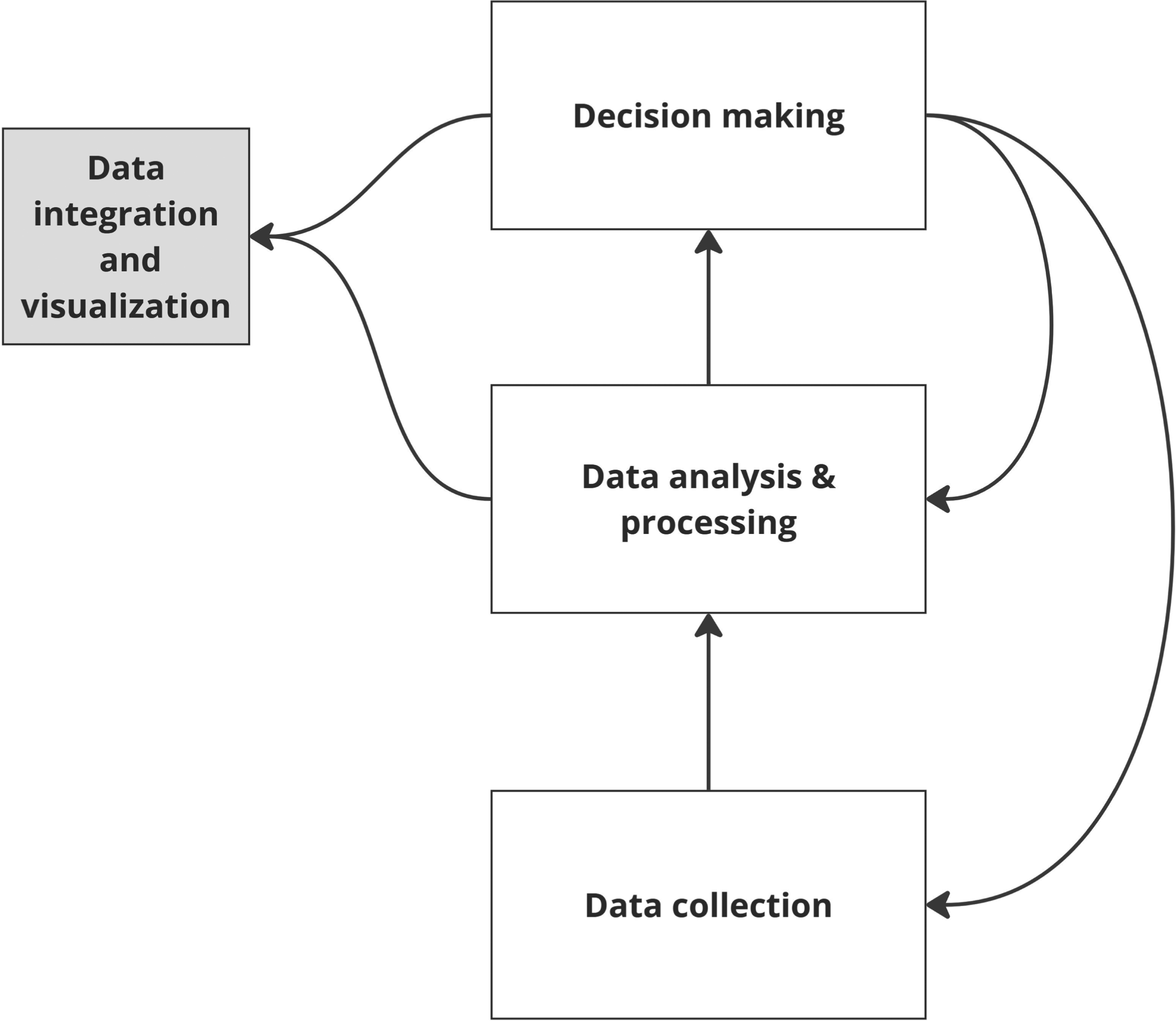
Data value cycle, Khorog - grey rectangles denote external actors.
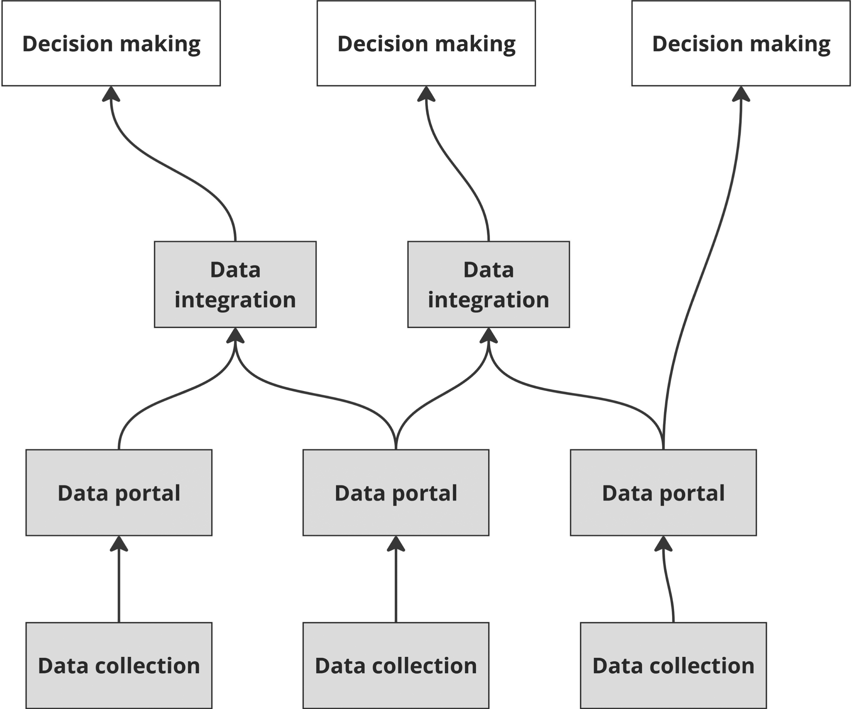
Data value cycle, Bosaso - grey rectangles denote external actors.
Case Studies.
Coding Structure.
Modes of Knowledge Use in the Cases.
How is Data Mobilized to Derive Evidence for Urban Planning Exercises?
eThekwini
In eThekwini, the approach to collecting and using data for urban planning has historically operated without a systematic framework, resulting in a fractured landscape where information flows are dictated by the isolated operational demands of specific municipal departments. The information gathered is primarily oriented towards the operational demands of municipal departments, covering diverse areas such as planning applications, traffic incidents, and flood occurrences. While these data points serve immediate administrative needs, they are not always integrated into a cohesive evidence base for strategic planning.
Consequently, for major planning initiatives like the Spatial Development Framework (SDF), the main planning document at urban level, the municipality has typically relied on external consultants rather than internal staff for data collection. The evidence gathered for these plans is determined on an ad hoc basis, although various departments, including those responsible for transport and land use, are solicited for input. This process of collecting data specifically for each project, without a standardized protocol, leads to inconsistencies and gaps in the information used to inform city planning.
To resolve these fragmentation issues, the city has developed Strat Hub, a centralized platform designed to serve as a unified access point for all spatial data owned by the municipality 1 . This system restructures the data flow: rather than remaining trapped in silos or extracted by consultants, spatial data is curated by each respective municipal department and channeled into this unified repository. This centralization mandates a harmonized system of metadata management, theoretically ensuring that all departments contribute to a shared, standardized resource. By aiming to eliminate redundant collection efforts, the architecture of Strat Hub is intended to transform the flow of information from a series of disconnected trickles into a cohesive stream accessible to decision-makers and the public alike.
When analyzing this system, distinct patterns emerge regarding how these bulk of data is utilized as knowledge and evidence. The platform has proven highly effective in fostering conceptual utilization. By providing a unified access point, Strat Hub allows decision-makers to visualize complex intersections—such as the relationship between land use changes and flood risks—thereby broadening their understanding of urban dynamics and reframing how they perceive policy issues. Parallel to this, the evidence is successfully leveraged for strategic utilization. Policymakers use the platform's scenarios to demonstrate to government officials how compromises for sustainable development yield superior outcomes compared to alternatives. This strategic deployment of evidence has been helpful in earning necessary political buy-in from both grassroots and institutional stakeholders, validating specific planning mandates.
However, the system faces significant challenges in other modes of use. Despite its conceptual value, the platform struggles with instrumental utilization. Because Strat Hub functions as a static repository of data snapshots rather than a real-time resource, the information becomes outdated quickly. Consequently, external actors often bypass the platform to contact departments directly for the most current figures, undermining the platform's role as a technical tool for daily decision-making.
Finally, while the centralized governance model ensures standardization, its rigid framework severely inhibits collaborative innovation. It restricts external experts from contributing to data curation or applying the data to novel, unforeseen applications. This lack of flexibility stifles the potential for positive spillover effects, preventing the data ecosystem from evolving to meet the needs of a broader range of users.
Khorog
In Tajikistan, the trajectory of urban planning is governed by a rigid, top-down data flow dictated by national legislation, which enforces a standardized inventory of required information for the drafting of any new general plan. This statutory framework aims to streamline procedures across the country, creating a uniform pipeline where data is collected by the national planning authority and fed into local master plans. However, this centralized mechanism acts as a filter that frequently excludes critical, localized realities. In the case of Khorog, where rockfalls and avalanches pose severe natural hazards, the standardized data collection protocols fail to capture these unique environmental constraints. Consequently, vital context-specific information is omitted from the official planning process, rendering the resulting plans structurally blind to the very risks they are meant to manage. This disconnect is exacerbated by an administrative opacity: while urban plans are technically public documents, the foundational data remains confidential, and the plans themselves lack spatialized analysis or evidence-based narratives to explain their rationale. As a result, these documents are largely perceived as legislative formalities rather than functional technical guides, leading to suboptimal implementation and a profound lack of public trust.
Against this backdrop of institutional rigidity, interventions by international actors such as UN-Habitat and the Aga Khan Agency for Habitat (AKAH) have introduced a parallel data ecosystem designed to bridge these information gaps. By analyzing these interventions, we can observe a distinct shift in how knowledge is utilized across the four modes.
The intervention has been most transformative in terms of conceptual utilization. By disseminating visual boards and maps that explicitly highlight hazard-prone areas, these organizations have provided a “common language” for risk. This enriches the stakeholders’ understanding of their environment, shifting the collective mindset from viewing disasters as unpredictable acts of fate to understanding them as spatial realities that can be mapped and managed.
This shift in understanding facilitates strategic utilization. The transparency provided by these public-facing maps empowers residents to question potentially risky developments in their localities. Furthermore, the use of management scenarios helps illustrate the benefits of compromise, allowing data to be used strategically to build consensus and advocate for safer urban expansion patterns that might otherwise face resistance.
In terms of instrumental utilization, the contrast is stark. While the official national plans fail to serve as effective technical instruments due to the exclusion of hazard data, the parallel data resources created by AKAH and UN-Habitat have become essential tools for immediate decision-making regarding safety zones and land suitability.
Finally, these efforts demonstrate how translating and locally adapting data can unlock its broader potential. By making English technical data widely accessible in Russian, the initiatives have created a foundational knowledge base for local stakeholders to repurpose. This reduces barriers to entry, allowing the data to generate positive spillover effects and be applied to unforeseen local challenges beyond the original projects’ scope.
Bosaso
In Bosaso, the landscape of data collection, analysis, and use is primarily dominated by external actors and international organizations. These entities typically concentrate their efforts on isolated projects with clearly defined spatial, temporal, and thematic boundaries.
Data movement within this framework is almost exclusively flowing from field activities up to the policy-making levels, with very little reverse flow where insights from policy could inform and enhance field operations. This one-way communication leads to a situation where top-down standards and policies are often misaligned with on-the-ground realities. These standards are frequently overlooked or adapted in an ad hoc manner to fit specific local circumstances, which undermines their effectiveness and the overall quality of data governance.
Moreover, there exists a competitive environment where different actors vie for limited resources, including financial and human capital. This competition makes these entities reluctant to share data, particularly within themes that are closely related, as each group seeks to maintain its advantage and autonomy. This reluctance to share further perpetuates the issues of data replication and inconsistency.
Despite this prevalence of fragmentation and competition, an analysis of the exceptions—specifically the collaborative efforts between certain communities of practice—reveals how different modes of knowledge utilization emerge.
Instrumental utilization remains highly localized. This allows individual projects to utilize data effectively for their specific goals. The collaborative practices highlight a shift where data quality and immediate applicability are enhanced when thematic groups align their methodologies. However, the lack of overall integration means the city lacks a functioning instrument for comprehensive governance.
In terms of strategic utilization, the landscape is currently defined by its absence. The reluctance to share data due to competitive pressures prevents the formation of a unified strategic vision. The identified need for a “central guidance system” represents a demand for a tool that could facilitate strategic alignment, bridging the divides between competing interests to allow for city-wide advocacy rather than project-specific survival.
Conceptual utilization is similarly fractured. Without a central mechanism to harmonize standards, there is no shared conceptual framework for the city's development. However, the grassroots collaboration between specialized thematic groups demonstrates how conceptual consensus can be built from the bottom up, creating robust methodologies that challenge the ad hoc nature of the dominant system.
Finally, the potential for data to generate extended value is evident but under-realized. While communities of practice have successfully repurposed data—proving that lowered competitive barriers allow information to serve broader contexts—rigid silos and a lack of central guidance remain bottlenecks. These structural issues stifle positive spillover effects and prevent the widespread reuse of evidence.
Emerging Themes and Common Lessons
EBUP Objectives and Evidence Definition
While interviewees acknowledged that a clear objective is critical for developing persuasive narratives and supporting coherent urban development arguments in EBUP, they frequently struggled to articulate specific, actionable goals for evidence formulation. This disconnect suggests that while the rhetorical value of being evidence-based is recognized, the alignment of data collection with precise analytical targets is often secondary. Our analysis emphasizes that this ambiguity is not merely a procedural oversight but reflects the complex ecosystem of multiple, interacting modes of use for evidence—see Table 3 (Jørgensen, 2024; McKenzie et al., 2014).
Within this ecosystem, a hierarchy of objectives appears. The principal objective utilized in these contexts is conceptual. Here, the primary function of evidence is to align planning initiatives with broader political agendas, thereby securing the necessary political support to ensure project implementation. In contested urban environments, data serves less as a mechanism for technical optimization and more as a tool for legitimacy. This political dimension underscores the necessity of prioritizing data governance strategies that are acutely sensitive to specific cultural and institutional contexts (Jørgensen, 2024). By aligning data governance with these realities, urban planners can navigate complex political landscapes, using evidence to bridge the gap between technical necessity and political feasibility. Consequently, while instrumental and strategic modes are present, they are often relegated to a supporting role, limited to the technical formulation of plans and the operational monitoring of urban services and resource allocation (Boswell, 2008; van Kerkhoff & Lebel, 2006).
However, beyond these established categories, an additional mode of utilization—that we termed generative—emerges. This mode aims to construct a knowledge base for potential, innovative, and unforeseen applications beyond current necessities. By generating agile and standardized data resources, this mode creates opportunities for positive spillover effects (Van Ooijen et al., 2019): information assets originally collected for a specific purpose—such as traffic monitoring—can catalyze value in adjacent domains, such as real-time flood risk analysis or economic forecasting.
Yet, the realization of this generative potential is severely hampered by a lack of conceptual clarity regarding what constitutes evidence. In all our cases, the data value cycle currently operates as an open loop, where primary data gathering is treated as a one-off expenditure rather than a capital investment. Because data is not standardized for broader analytical products, it effectively “dies” after its initial use. This reveals a prevalent tension between data's fitness for immediate, ad hoc use and its suitability for future repurposing, effectively blocking the accumulation of institutional knowledge (Tonnarelli & Mora, 2025a).
This misalignment precipitates a distinct tension in planning priorities. On one side, the intensifying focus on dynamic data for immediate action suggests a priority shift toward reactive measures—leveraging data to manage immediate crises rather than for sustained, long-term planning (Batty, 2013; Engin et al., 2020). On the other, the emphasis on generative data reuse (Sinnott et al., 2015) underscores the necessity for a more integrated, infrastructural approach to data management. Such an approach aims to bridge the gap between immediate operational needs and long-term strategic goals, transforming data from a consumable good into a renewable asset (Tseng & Nikiforova, 2025; Zuiderwijk et al., 2014).
Complicating this tension is the pervasive narrative of data scarcity (Milan & Treré, 2020), which this analysis suggests is frequently a misinterpretation of structural barriers rather than a physical lack of data. The primary issue is not the absence of data, but the politicized restriction of access to it. In contexts like Khorog and Bosaso, a lack of institutional transparency obscures the existence of data, fostering a false impression of scarcity. In eThekwini, the phenomenon is driven by internal power dynamics, where data is compartmentalized and hoarded by siloed departments to maintain autonomy. Consequently, stakeholders are left requesting new data collection not because the information does not exist, but because they cannot reach it. Thus, our cases point toward a need for systems that are not only dynamic enough to handle rapid urbanization and crises but also structurally open enough to support the political, technical, and generative dimensions of modern urban governance.
Factors Affecting Evidence use
Based on our comparative analysis, it is evident that the utilization of evidence is a composite outcome shaped by the convergence of planning processes, data product, and contextual conditions (Jiang et al., 2020).
First, the characteristics of the planning and policy process determine whether the evidence finds a functional entry point. Time pressure and the specific rhythm of planning phases are decisive factors. In eThekwini, a temporal misalignment exists where data updates lag behind the decision-making cycle, rendering the evidence technically valid but operationally irrelevant. Similarly, the structural design of the process in Bosaso creates a barrier; the workflow is characterized by a unidirectional, upward extraction of data. This design ignores the operational layer, preventing field staff from utilizing insights and effectively severing the link between evidence generation and ground-level implementation.
Second, the specific characteristics of the evidence significantly influence its uptake (Tonnarelli & Mora, 2025a; Tseng & Nikiforova, 2025). Adaptability to user needs is particularly critical here. In Khorog, the data products developed by AKAH demonstrated high adaptability to the local population's linguistic and technical requirements. This alignment transformed residents into active uptakers of the information. Conversely, in Bosaso, the utility of evidence is constrained by the specifications of the data products themselves, defined by spatial and thematic boundaries that individual projects rather than city level outcome. This siloed approach requires significant collaboration between specialized thematic groups to overcome ad hoc methodologies.
Finally, political context and stakeholder characteristics act as the ultimate determinants of how evidence is deployed (Head, 2010; Ribeiro et al., 2019). In Bosaso, the influence of international actors and the severe resource scarcity fosters a competitive environment that fundamentally alters user attitudes. Rather than viewing data for evidence as a shared public good, stakeholders adopt a protective stance, hoarding information to maintain institutional autonomy. Meanwhile, in eThekwini, political pressure to harmonize diverse stakeholder interests shifts the primary function of evidence from technical optimization to consensus building. Here, the political system incentivizes the use of data to construct unifying narratives rather than for pure instrumental calculation.
Good Enough Evidence for Good Enough Planning
The comparative assessment of Bosaso, Khorog, and eThekwini reveals that while none of these cities fully comply with the ideal data value cycle or the optimal steps of EBUP (Van Ooijen et al., 2019), functional outcomes are nonetheless generated. This suggests that the question is not whether evidence is objectively perfect, but whether it is functionally sufficient for the constraints at hand. Data and the evidence that is derived from it may be good enough to fulfill specific, localized planning intents and fit within current institutional constraints, yet the ecosystem as a whole remains insufficient for performing the new, complex tasks demanded by good data governance frameworks (Kayanan et al., 2025).
Because formal systems often fall short of the ideal, the functionality of evidence frequently relies on workarounds to bridge the gap between systemic deficits and operational needs. In Khorog, the official system's inability to capture hazard data necessitated a parallel intervention by international NGOs to ensure safety; in eThekwini, the rigidity of the central platform forces users to bypass formal channels to find timely data. In Bosaso, collaboration among communities of practice and other networks creates a more horizontal, reciprocal exchange bypassing silos. These workarounds – and the fact that the system allows them - demonstrate that while the data ecosystem may be structurally flawed, the outcomes can still be good enough to support critical decisions if the interventions are adapted to the reality of the environment.
Therefore, the efficacy of particular evidence cannot be evaluated against a universal standard but must be assessed by analyzing the specific context for change and the implications of the intervention. While the concept of good enough may lack the precision to prescribe specific technical actions in every real-world context (Grindle, 2007), it offers a strategic lens. Adopting good enough evidence implies that interventions intended to bolster evidence-based planning must be rigorously questioned, prioritized, and made relevant to the unique conditions of individual cities and their data environment—including what data exists, how it is accessed, and its quality (Gabrys et al., 2016). Rather than striving for a blind adoption of global best practices, data strategies need to be assessed in the light of historical evidence, sequence, and timing (Grindle, 2007; Saidi et al., 2024). They should be selected carefully, not for their technical sophistication, but for their contributions to particular ends—such as enhancing spatial equity, mitigating climate risks, or optimizing infrastructure investment—ensuring that the evidence acts as a relevant tool for development rather than an abstract administrative burden.
Conclusion and Limitations
This study highlights the complex dynamics of implementing evidence-based urban planning in secondary cities of the Global South, providing insights into the political, institutional, and data-driven challenges that shape these processes. The principal contributions of our analysis are three-fold.
First, we chart the transformation of data into usable knowledge and actionable evidence, highlighting the specific attributes of EBUP and the processual aims that dictate utilization. We identify the generative mode of knowledge use, expanding existing frameworks (McKenzie et al., 2014) by recognizing that data resources can create value beyond their initial intended purpose, fostering innovation and spillover effects when governance structures allow for it.
Second, we demonstrate the significance of mapping data flows within urban planning ecosystems (Bates et al., 2016; Kitchin et al., 2025). By tracing the trajectory of data from collection to application, we can identify bottlenecks, inefficiencies, and potential areas for technological and methodological enhancements (Bates, 2018). In doing this, we highlight how EBUP rarely follows the good data value cycle (Van Ooijen et al., 2019) but rather is subject to contextual adjustments that contribute to some level of good outcomes, although far from ideal. This mapping therefore serves as a diagnostic tool, providing planners and policymakers with clear insights into how data can be better managed and utilized to meet urban planning objectives effectively.
Third, we explore and refine the notion of good enough applied to evidence based planning (Gabrys et al., 2016; Kayanan et al., 2025). We argue that the significance of evidence should be assessed not merely by metrics of accuracy or comprehensiveness, but by its fitness relative to specific purposes, users, and environmental contexts (Kayanan et al., 2025). This paradigm shifts the evaluation focus from abstract rigor to contextual relevance, ensuring that the evidence deployed is aligned with the strategic capabilities and constraints of the urban development goals it serves.
As a practical contribution, our analysis explores the applications of evidence-based urban planning in real scenarios. There remains scattered and scant academic work relating to secondary cities in developing countries, and this paper provides an update in that regard. This exploration reveals the acceptable boundaries of good enough planning practices and how they vary among different groups and stakeholders. Recognizing these boundaries is crucial for implementing realistic and effective planning strategies that are sensitive to the resource constraints and socio-economic conditions prevalent in developing contexts.
While this study provides valuable insights, it is not without limitations. The focus on secondary cities, though significant, limits the generalizability of our findings to larger metropolitan areas or different geographical contexts. Additionally, the qualitative nature of our research may not capture all quantitative aspects of data flows and evidence uses in urban planning. Future research could benefit from incorporating quantitative methods to provide a broader statistical context to our qualitative findings. Moreover, as our study primarily involves a small number of case studies, expanding the research to include more cities could offer a more comprehensive view of the challenges and strategies in evidence-based urban planning globally.
Footnotes
Acknowledgments
We wish to acknowledge all of the people and organizations that we interviewed for their time, care and dedication. We extend our sincere appreciation to Sara Thabit for her insightful and generous feedback throughout the development of this manuscript.
Ethical Approval and Informed Consent Statements
Informed consent was obtained verbally before participation.
Funding
The authors disclosed receipt of the following financial support for the research, authorship, and/or publication of this article: This work has been partially supported by the European Commission through the Horizon 2020 project FinEst Twins (Grant Agreement No. 856602).
Declaration of Conflicting Interests
The authors declared no potential conflicts of interest with respect to the research, authorship, and/or publication of this article.
Notes
Authors Biographies
Appendix
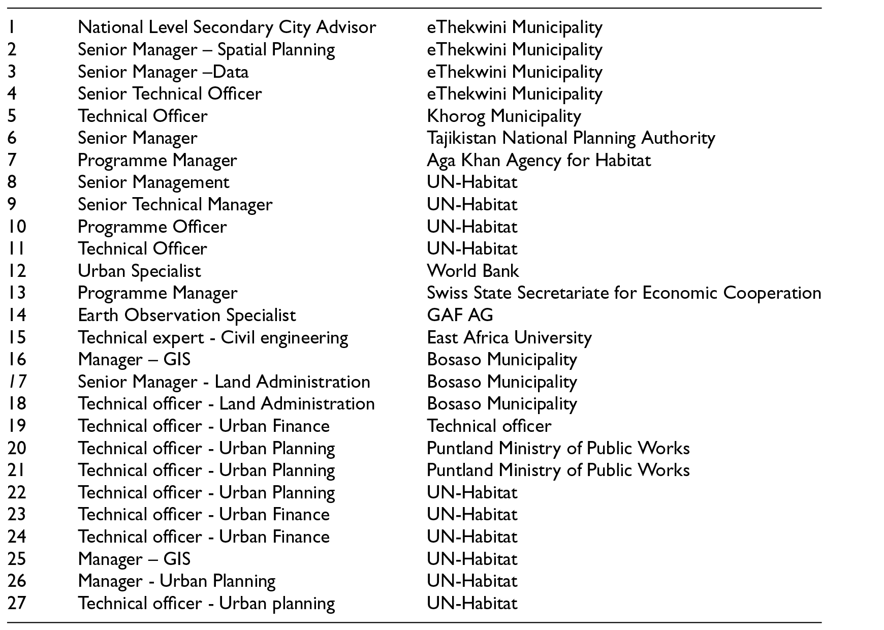
| 1 | National Level Secondary City Advisor | eThekwini Municipality |
| 2 | Senior Manager – Spatial Planning | eThekwini Municipality |
| 3 | Senior Manager –Data | eThekwini Municipality |
| 4 | Senior Technical Officer | eThekwini Municipality |
| 5 | Technical Officer | Khorog Municipality |
| 6 | Senior Manager | Tajikistan National Planning Authority |
| 7 | Programme Manager | Aga Khan Agency for Habitat |
| 8 | Senior Management | UN-Habitat |
| 9 | Senior Technical Manager | UN-Habitat |
| 10 | Programme Officer | UN-Habitat |
| 11 | Technical Officer | UN-Habitat |
| 12 | Urban Specialist | World Bank |
| 13 | Programme Manager | Swiss State Secretariate for Economic Cooperation |
| 14 | Earth Observation Specialist | GAF AG |
| 15 | Technical expert - Civil engineering | East Africa University |
| 16 | Manager – GIS | Bosaso Municipality |
| 17 | Senior Manager - Land Administration | Bosaso Municipality |
| 18 | Technical officer - Land Administration | Bosaso Municipality |
| 19 | Technical officer - Urban Finance | Technical officer |
| 20 | Technical officer - Urban Planning | Puntland Ministry of Public Works |
| 21 | Technical officer - Urban Planning | Puntland Ministry of Public Works |
| 22 | Technical officer - Urban Planning | UN-Habitat |
| 23 | Technical officer - Urban Finance | UN-Habitat |
| 24 | Technical officer - Urban Finance | UN-Habitat |
| 25 | Manager – GIS | UN-Habitat |
| 26 | Manager - Urban Planning | UN-Habitat |
| 27 | Technical officer - Urban planning | UN-Habitat |
Appendix
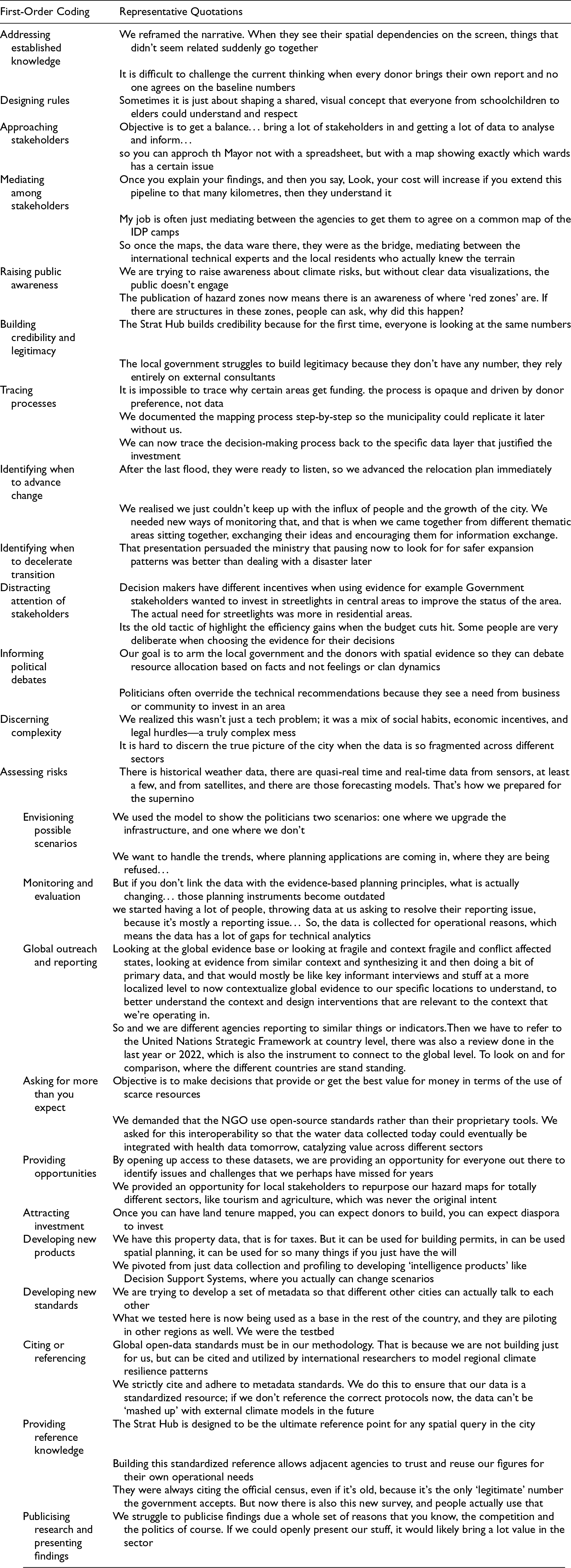
| First-Order Coding | Representative Quotations |
|---|---|
| Addressing established knowledge | We reframed the narrative. When they see their spatial dependencies on the screen, things that didn't seem related suddenly go together |
| It is difficult to challenge the current thinking when every donor brings their own report and no one agrees on the baseline numbers | |
| Designing rules | Sometimes it is just about shaping a shared, visual concept that everyone from schoolchildren to elders could understand and respect |
| Approaching stakeholders | Objective is to get a balance… bring a lot of stakeholders in and getting a lot of data to analyse and inform… |
| so you can approch th Mayor not with a spreadsheet, but with a map showing exactly which wards has a certain issue | |
| Mediating among stakeholders | Once you explain your findings, and then you say, Look, your cost will increase if you extend this pipeline to that many kilometres, then they understand it |
| My job is often just mediating between the agencies to get them to agree on a common map of the IDP camps | |
| So once the maps, the data ware there, they were as the bridge, mediating between the international technical experts and the local residents who actually knew the terrain | |
| Raising public awareness | We are trying to raise awareness about climate risks, but without clear data visualizations, the public doesn't engage |
| The publication of hazard zones now means there is an awareness of where ‘red zones’ are. If there are structures in these zones, people can ask, why did this happen? | |
| Building credibility and legitimacy | The Strat Hub builds credibility because for the first time, everyone is looking at the same numbers |
| The local government struggles to build legitimacy because they don't have any number, they rely entirely on external consultants | |
| Tracing processes | It is impossible to trace why certain areas get funding. the process is opaque and driven by donor preference, not data |
| We documented the mapping process step-by-step so the municipality could replicate it later without us. | |
| We can now trace the decision-making process back to the specific data layer that justified the investment | |
| Identifying when to advance change | After the last flood, they were ready to listen, so we advanced the relocation plan immediately |
| We realised we just couldn't keep up with the influx of people and the growth of the city. We needed new ways of monitoring that, and that is when we came together from different thematic areas sitting together, exchanging their ideas and encouraging them for information exchange. | |
| Identifying when to decelerate transition | That presentation persuaded the ministry that pausing now to look for for safer expansion patterns was better than dealing with a disaster later |
| Distracting attention of stakeholders | Decision makers have different incentives when using evidence for example Government stakeholders wanted to invest in streetlights in central areas to improve the status of the area. The actual need for streetlights was more in residential areas. |
| Its the old tactic of highlight the efficiency gains when the budget cuts hit. Some people are very deliberate when choosing the evidence for their decisions | |
| Informing political debates | Our goal is to arm the local government and the donors with spatial evidence so they can debate resource allocation based on facts and not feelings or clan dynamics |
| Politicians often override the technical recommendations because they see a need from business or community to invest in an area | |
| Discerning complexity | We realized this wasn't just a tech problem; it was a mix of social habits, economic incentives, and legal hurdles—a truly complex mess |
| It is hard to discern the true picture of the city when the data is so fragmented across different sectors | |
| Assessing risks | There is historical weather data, there are quasi-real time and real-time data from sensors, at least a few, and from satellites, and there are those forecasting models. That's how we prepared for the supernino |
| Envisioning possible scenarios | We used the model to show the politicians two scenarios: one where we upgrade the infrastructure, and one where we don't |
| We want to handle the trends, where planning applications are coming in, where they are being refused… | |
| Monitoring and evaluation | But if you don't link the data with the evidence-based planning principles, what is actually changing… those planning instruments become outdated |
| we started having a lot of people, throwing data at us asking to resolve their reporting issue, because it's mostly a reporting issue… So, the data is collected for operational reasons, which means the data has a lot of gaps for technical analytics | |
| Global outreach and reporting | Looking at the global evidence base or looking at fragile and context fragile and conflict affected states, looking at evidence from similar context and synthesizing it and then doing a bit of primary data, and that would mostly be like key informant interviews and stuff at a more localized level to now contextualize global evidence to our specific locations to understand, to better understand the context and design interventions that are relevant to the context that we're operating in. |
| So and we are different agencies reporting to similar things or indicators.Then we have to refer to the United Nations Strategic Framework at country level, there was also a review done in the last year or 2022, which is also the instrument to connect to the global level. To look on and for comparison, where the different countries are stand standing. | |
| Asking for more than you expect | Objective is to make decisions that provide or get the best value for money in terms of the use of scarce resources |
| We demanded that the NGO use open-source standards rather than their proprietary tools. We asked for this interoperability so that the water data collected today could eventually be integrated with health data tomorrow, catalyzing value across different sectors | |
| Providing opportunities | By opening up access to these datasets, we are providing an opportunity for everyone out there to identify issues and challenges that we perhaps have missed for years |
| We provided an opportunity for local stakeholders to repurpose our hazard maps for totally different sectors, like tourism and agriculture, which was never the original intent | |
| Attracting investment | Once you can have land tenure mapped, you can expect donors to build, you can expect diaspora to invest |
| Developing new products | We have this property data, that is for taxes. But it can be used for building permits, in can be used spatial planning, it can be used for so many things if you just have the will |
| We pivoted from just data collection and profiling to developing ‘intelligence products’ like Decision Support Systems, where you actually can change scenarios | |
| Developing new standards | We are trying to develop a set of metadata so that different other cities can actually talk to each other |
| What we tested here is now being used as a base in the rest of the country, and they are piloting in other regions as well. We were the testbed | |
| Citing or referencing | Global open-data standards must be in our methodology. That is because we are not building just for us, but can be cited and utilized by international researchers to model regional climate resilience patterns |
| We strictly cite and adhere to metadata standards. We do this to ensure that our data is a standardized resource; if we don't reference the correct protocols now, the data can't be ‘mashed up’ with external climate models in the future | |
| Providing reference knowledge | The Strat Hub is designed to be the ultimate reference point for any spatial query in the city |
| Building this standardized reference allows adjacent agencies to trust and reuse our figures for their own operational needs | |
| They were always citing the official census, even if it's old, because it's the only ‘legitimate’ number the government accepts. But now there is also this new survey, and people actually use that | |
| Publicising research and presenting findings | We struggle to publicise findings due a whole set of reasons that you know, the competition and the politics of course. If we could openly present our stuff, it would likely bring a lot value in the sector |