
Abstract
Longwall mining is a productive mining method that has been widely used in China, the United States, Australia, and Europe. However, due to the subsidence caused by coal mining activities, the phenomenon is complex, longwall mining brings the overburden movement issues accompany with the coal recovery. In subsidence trough, the resulting strata and surface ground movements are regarded as largely contemporaneous with mining, producing more or less direct effects of natural ecology. Ground penetrating radar has been widely used in geological hazard detection due to its high precision, but it is rarely employed in underground measuring the overlying strata movement above the longwall panel. In this article, there are five close-multiple coal seams (5#, 7#, 8#, 9#, 12# seams) within 70 m distance to be monitored in Qian Jiaying coal mine of Kailuan Coal Company in Hebei province. The 7#, 8#, 9#, 12# coal seams were already excavated in sequence. So the 5# coal seam is overmining above the gobs of four coal seams at the top. The ZTR12-series ground penetrating radar equipment is used to detect the development of fractures under the floor of the 5# coal seam. The ZTR12-series ground penetrating radar system has the capability of large depth detection and explosion proof to adapt to the working environment of underground coal mines and can realize fine detection and accurate identification. The maximum detection distance of reflection method can reach 50 m. The measurement results show that the 5# coal seam is in the fracture zone above the gobs of four coal seams, and the caved zone of lower coal seam develops to fine sandstone of the 5# coal seam floor. The ground penetrating radar has shown much promise in the detection of overlying strata movement.
Introduction
According to the report of “Statistical Review of World Energy” British Petroleum (BP), China became the world’s largest energy consumer in 2010. China is not an energy-rich country. It is short of oil and gas resources, but coal energy is relatively abundant. Therefore, in terms of types of energy consumption in China, coal resource is the main energy, accounting for about 70% of the total energy consumption. This type of energy consumption is difficult to change in the short term.
China is the largest coal producing country in the world as well. Coal is widely distributed in China, and thus, the mining conditions are complex and diverse. In consideration of the prevailing conditions of coal reserves, China’s coals are mainly mined by underground methods. Underground coal mining produced about 88% of total production. Even if in the future surface coal mining has fully developed, the percentage of underground coal mining production will not be less than 85% of the total; 90% of underground coal mining is basically longwall mining in China. Longwall mining method is a commonly used method of coal extraction that involves the complete removal of large, rectangular panels of coal. Since it causes subsidence through the overlying strata to the ground surface, the surface- and groundwater above the longwall panels may be affected and drained into the lower levels.1–3 When the excavated longwall panel is wide and long enough, the overlying strata, from the immediate roof all the way to the surface and even the aquifer, are seriously disturbed, causing serious mining leaching accidents and increasing the damage to the ecological environment. Therefore, the determination of overlying strata movement is absolutely necessary to prevent water inrush and avoid the loss of groundwater resources. Coal is widely distributed in China. All provinces, autonomous regions, and municipalities have coal resources for mining except Hong Kong and Shanghai. In terms of coal seam thickness, dip, methane gas, geological conditions, and hydrogeological conditions, China’s coal resources can be divided into three types: less difficult mining, difficult mining, and extremely difficult mining. Due to the large amount of coal production in China from various complex mining conditions, mining methods vary considerably. Consequently, there are different mining methods with different special features for different coal reserves. The close-multiple coal seams mining method is extremely difficult to excavate under the interaction influence between each coal seams mining process. The movement characteristics of close-multiple coal seams overlying strata are not limited to the whole overlying strata collapse and step subsidence. In fact, different geological conditions, such as different mining height, overlying strata, and bedrock thickness, will produce different subsidence movement characteristics. The purpose of this study is to determine the effects of longwall mining overlying strata movement by using a detection equipment: ground penetrating radar (GPR).
The GPR method is a broad-spectrum electromagnetic wave technique for determining the distribution of underground media. It is a new technology for the underground detection and non-destructive detection of concrete buildings in recent years. This technology has low antenna shielding interference, wide detection range, and high resolution.4,5 It can also process real-time data and enhance signal. It can be used to scan continuous subject or single-point perspectively to display two-dimensional (2D) color images in real time.
The longwall panel 1356 studied in this article is located in Tangshan, Hebei province in mid-eastern China, where most coal seams are close-multiple seams. With a depth of 575 m, the overlying strata are mostly bedrock; the panel width and panel length can reach up to 145 and 840 m, respectively, which is common in China. Panel 1356 is in 5# coal seam on the top. The thickness is 0.5 to 2.3 m, average 1.4 m. Dip angle is 3° to 22°, average 9°. There are four close-multiple coal seams below panel 1356: 7#, 8#, 9#, 12# coal seams. The characteristics of these five coal seams are as follows: the 5# coal seam is a thin coal seam with high sulfur content and ash content in coal property. Some areas of 5# coal seam are pinch-out. The thick coal seams with high quality are located in the middle and lower coal seams (7#, 12# coal seams). If the mining sequence is from the top to the bottom, there would be lowest productivity due to the thin coal seam of mining 5# first. However, if the mining sequence is from the bottom to the top, there would be more interaction between coal seams because the thickness of interburden is so close in these five coal seams. By considering the quality, thickness, and interaction of these coal seams, the final mining sequence is 7#-8#-9#-12#-5#. Therefore, 5# coal seam would be overmining above all the gobs that made by the other four seams mined out. Thus, in this case, the practical experience of GPR detection and the theories developed provide the basis for further research on close-multiple coal seams mining in eastern China.
The ZTR12-series geological radar equipment is used to detect the development of fractures in the floor of tailgate of 1356 panel face in underground longwall coal mining, and the situation of the lower gob collapsed and compacted (Figure 1). According to the design requirements, the center frequency of the ZTR12 antenna is designed to be 50 MHz, and the geometric size of a single detachable antenna is not >1 m, so as to meet the needs of entreating and adapt to the mining application environment. The output signal width is narrow (20 ns) with higher voltage (90 V), and the four-step avalanche circuit is adopted. The generated 50-MHz transmitting pulse can be seen that the amplitude ratio of pulse to ripple is significantly increased to more than 30 dB. The accurate detection distance is within 50 m under the 5# coal seam.

Working face detection location diagram.
Working principle of GPR
An antenna is used to transmit broadband high-frequency electromagnetic waves to the ground as the radar system working. Reflection, transmission, and refraction occur when an electromagnetic wave signal encounters a dielectric interface with a large dielectric difference when propagating inside the medium. The greater the difference in dielectric constant between the two media, the greater the energy of the reflected electromagnetic wave.6,7 After the reflected electromagnetic wave is received by the receiving antenna that moves synchronously with the transmitting antenna, the radar host accurately records the motion characteristics of the reflected electromagnetic wave.8–10 Then, a radar scan image will be formed by signal technology11–13 processing. Through the interpretation of the image, the engineering technicians judge the actual structure of the underground target. The overburden movement and subsidence detected by this project are largely and electrically different from the surrounding rock medium. The working principle of GPR is shown in Figure 2.
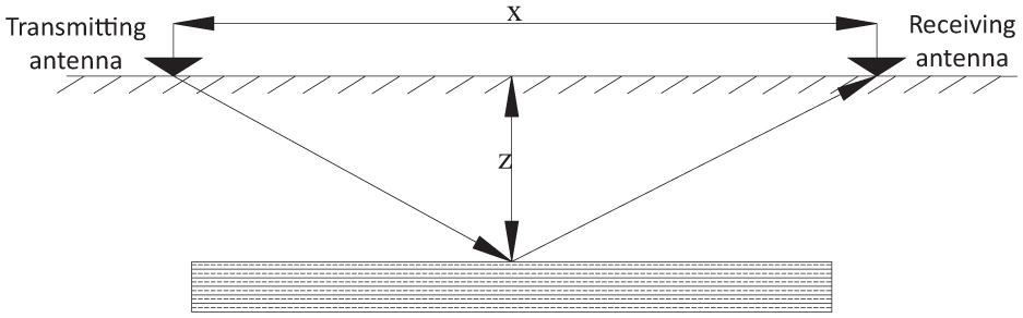
Ground penetrating radar working principle diagram.
The broadband high-frequency time-domain electromagnetic pulse wave reflection of GPR is mainly used to detect the target.
According to the interval between the transmitted wave and the reflected wave, the depth of the detected object can be obtained by using the formula. The formula is as follows

Based on the measured radar wave trend, the depth Z and range of the reflector are automatically determined. The electrical characteristics of common media are shown in Table 1. Considering the inhomogeneity of propagation medium in a certain range, the wave velocity of different media is set as a random value. A total of eight different types of media were considered: air, fresh water, limestone (dry), limestone (wet), sandstone (wet), shale (wet), dry coal, and wet coal.
Electrical characteristics of common media.

In the actual measurement, the radar antenna is attached to the detected surface and continuously slides along the line (or fixed point detection). Manual marking is used to position the antenna and the spatial sampling rate is set according to the system configuration and antenna sliding speed. The radar host records time and amplitude values of the reflected waves of each measuring point in real time to form a continuous radar profile. When the wave velocity of the local medium is known, the position and the depth of the target can be obtained based on the detected two-way travel. Professional software will be used to analyze the waveform and wave resistance characteristics of the reflected wave in phase axis, which can make sure the access of the media information below the detection surface.
Fieldwork
1. Line layout
According to the requirements of this test, the tailgate of the 1692 working face of Qian Jiaying mine, the transportation uphill, and the 1356 panel face tailgate will be chosen to detect. The position of the line is shown in Figure 3.
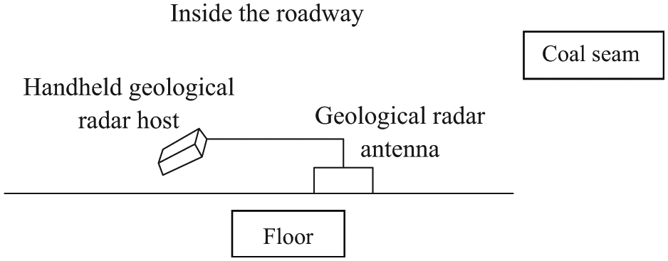
Schematic diagram of radar line layout.
Figure 3 shows the underground radar cross-section measurement design. The cross-section of survey lines parallel to the tailgate is detected. The radar antenna is installed on the floor of the selected cross-section, and the receiving radar host is handheld to capture the detection data. The distance between the handheld geological radar host and geological radar antenna is 2 to 3 m depended on the cable length. As geological radar antenna moves forward in a setup interval, each interval’s initial point is a measuring point. When using GPR to carry out cross-sectional survey and detection, a mark is fixed at the first transmitting point, and both the handheld geological radar host and the geological radar antenna are moved from the first receiving point to the last receiving point. The process is then repeated for each measurement point. The velocity tomography includes calculating the velocity field from the measuring point to the receiving point in the direct wave propagation time. Travel time is linearly proportional from speediness to slowness (inverse of speed). Relative to the inversion based on Eikonal equation, the ray inversion effect is better. In X-ray tomography, the field is discretized into a series of units. For each emitter–receiver pair, calculate the length of each ray path segment through the cell. All the segment lengths called the coefficient matrix are organized in a sparse matrix, which describes the geometry of the ray. There were 11 measuring points along the tailgate of panel 1356. The measurement length is 510 m.
2. Operating parameters
The parameter setting of the geological radar is related to the accuracy of the collected data quality and the detection effect. Therefore, the system parameters must be set according to the purpose of the detection and the situation on site. The specific parameters of this probe are shown in Table 2.
3. Workflow
Radar detection parameters.

The process of fieldwork and the whole project detection work is shown in Figure 4.
4. Field detection

GPR work flowchart.
The manual lifting of radar antenna to closely contact the plate is used for the roof and bottom detection. The data acquisition system adopts multi-thread design. The threads are mainly divided into the following: radar data acquisition thread, GPS data acquisition thread, image data acquisition thread, and data storage thread. The data acquisition of underground radar generally requires post-processing method. Since the deep-buried underground medium is equivalent to a complex filter, the electromagnetic wave amplitude decreases due to the absorption of electromagnetic waves in different media and non-uniform media, and the waveform changes greatly when the electromagnetic pulse reaches the receiving antenna. Therefore, we must correctly process the received signals to improve the data and provide clearer GPR images for data interpretation. The forward GPR mechanism can identify anomalies to a large extent and provide a basis for image interpretation. The traditional processing methods include one-dimensional (1D) filtering, background noise removal, gain adjustment, 2D filtering, deconvolution, wavelet transform, Hilbert transform, and terrain correction. In addition, the system also includes 2D and 3D (three-dimensional) interpretation systems for the function of automatic horizon tracking. Following the above process, the collected radar data are not interfered by irrelevant factors. The fieldwork is shown in Figure 5.

GPR worksite.
Data processing and interpretation
Pre-processing (marking, station correction, etc.) and post-processing analyses are included in the GPR data processing. The usefulness of the processing is to suppress regular and random interference, display the reflected waves on the GPR image profile with the highest possible resolution, and highlight useful anomalous information (including electromagnetic wave velocity, amplitude, and waveform) to enhance the explanation.
Radar data processing is an important step in the interpretation of the final results of GPR. Commonly used analysis methods include conventional filtering and other filtering processes. There are some main workflow processes: neutral line setting, 1D filtering, background denoising, automatic or manual gain control, moving average, and so on. Other filtering methods can be selected in combination with specific detection conditions, including wavelet transform, 2D filtering, deconvolution, and computation. The GPR data processing flow is shown in Figure 6.

Radar data processing.
From the perspective of radar time-profile analysis, the main analysis is about the lateral variation of radar waves at the same time depth in the horizontal direction. For common materials, the relative dielectric constant of water is the largest, the smallest is air, and others are between the two. Therefore, when the coal seam or surrounding rock of the roadway is diseased, the “solid, liquid, and gas” components of the structural layer will also change accordingly. The change of relative dielectric constant is one of the theoretical basis for the detection of soil defects behind the roadway by GPR.
Experimental results and analysis
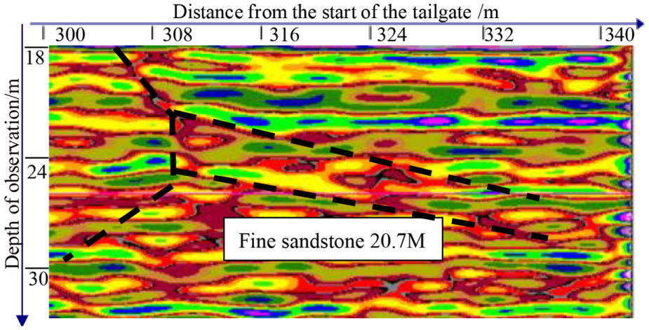
Figure 7 shows the development of the 1356 tailgate detection results. It can be seen that the geology on the left side of 435 m (the distance here is the distance from the start of the tailgate to the observation point, the same below) is relatively stable, and the geological conditions are regularly distributed. Detection areas with slight interference appear at 270, 345, 360, and 375 m. On the right side of 435 m, there is a clear detection interference zone. Combined with the signal transmission method, the abnormal signal in the lower part of the graph is analyzed, which is generated by the influence of the upper abnormal region. In the analysis, the first signal anomaly area is the main object. Considering the 1356 layout, the first abnormal region of the signal is concentrated in the area where 7# coal seam and the roof area of 7# coal seams are located, and there is a good reaction on all the detection paths. In the signal anomaly area, the seven coal seams and the top plate are within the range of about 20 m, which is a poorly detected area. It is speculated that this area is damaged after mining. Conclusion combined with the detection results can be made that the falling zone of the roof after 7# coal seam mining is about 20 m.

The result of the detection of the damage of 1356 tailgate floor (expanded map).
The regular signal anomaly that occurs in the lower part of the unfolded picture is mainly due to environmental interference (such as large iron blocks) as the radar antenna collecting data at this position, so that signal overflow occurs on the radar image.
Figure 8 shows an enlarged view of the local anomaly during the process of detecting the floor rock of the tailgate. According to the misalignment and movement of the figure, it is speculated that there may be a fault structure at this position. The overlying strata movement for the close-multiple coal seams mining has been generalized as follows: the fractured lower floors will absorb some dynamic loading from the lower coal seams excavated, thereby reducing the effect of its impact; the pressures in the front legs of the four-leg shield supports are larger than the rear legs. The peak front abutment pressure is smaller but distributes in larger area due to close-multiple coal seams mining. It is necessary to increase the setting load of the shield during the process of the shield that moves forward in mining the top 5# coal seam.

Local anomaly area of 1356 tailgate floor.
Figure 9 shows the anomalous area 1 detected along the floor of the 1356 tailgate. In this area, part of the image is out of phase with the axis. The position is 120 m from the starting point and 24 m below the 1356 tailgate floor, and the trajectory line, as shown in Figure 10, is connected. According to the shape of the trajectory, it is speculated that the rock layer is broken in this area.

Partial enlargement (abnormal zone 1).
Partial enlargement (abnormal zone 2).
The location of this anomaly zone is 120 m from the starting point and 24 m below the floor of the 1356 duct, and the abnormality is the dislocation of the image. The graph could be get after wrong track was connected. It is speculated that several curves show the dislocation of the rock strata, and there may be breakage and fall of the rock stratum. Combined with the above analysis, it is further inferred that this position is the roof collapse area after the seven coal seams mining, and the slump height is about 18 m.
Conclusion
China is the largest coal producing country in the world. Coal is widely distributed in China. However, the mining conditions are complex and diverse. In the last 20 years with the rapid development of Chinese economy, the demand for coal energy is so huge that it promotes the rapid development of coal mining technology, resulting in many highly productive mines. High production and high efficiency are inseparable from high-tech equipment. GPR has the advantages of high detection accuracy and has been widely used in geological disaster sources that seriously threaten the safety of underground coal mine production. In this article, GPR was first employed in detecting overlying strata movement. There are some characteristics of detecting overlying strata movement with the GPR method, such as high detection precision, convenient construction, and great efficiency. These characteristics can make the construction and mining safe, accurately identify the source of mine disasters, and reduce risks. Through the practical application of the GPR detection of Qian Jiaying mine 1356 tailgate, the working principle, detection method, and data processing flow are analyzed. The radar scan map is formed with the signal technology processed, and the development of fractures under the floor of the 5# coal seam is inferred. The ZTR12 GPR system has the capability of large depth detection and explosion proof to adapt to the working environment of underground coal mines, and can realize fine exploration and the accurate identification within 50 m under the 5# coal seam. The 5# coal seam is in the fracture zone above the gobs of four coal seams, and the caved zone of lower coal seam develops to fine sandstone of the 5# coal seam floor. Moreover, the detection accuracy of close-multiple coal seam mining can reach to 3 m, proposing an advanced detection method to determine the overlying strata movement for improving mining safety. But there are still ample room to improve. Eventually, the GPR has shown much promise in the detection of overlying strata movement in close-multiple coal seams mining.
Footnotes
Handling Editor: Antonio Lazaro
Declaration of conflicting interests
The author(s) declared no potential conflicts of interest with respect to the research, authorship, and/or publication of this article.
Funding
The author(s) disclosed receipt of the following financial support for the research, authorship, and/or publication of this article: The research is supported by National Key R&D Program of China (No. 2017YFC060300204), Yue Qi Young Scholar Project, CUMTB, Yue Qi Distinguished Scholar Project (No. 800015Z1138), and China University of Mining & Technology, Beijing.