
Abstract
This article reviews the urban revitalization and modernization actions of Oran’s Front de Mer, from the late nineteenth to the middle of the twentieth century. Throughout this period, when Algiers was undergoing a transformation based on the classical Haussmannian urban model, Oran stands out as an atypical example for the development of its urban planning projects. The research evidence, extracted for the first time from archival documents, reveals an advanced use of urban design concepts from the 1960’s, similar to the American model of waterfront revitalisation and deck urbanism developed in France.
Keywords
The identity of the coastal city of Oran in north-west Algeria is inextricably linked to its role as a port city and its relationship with the sea. From the Portus Divini of Roman times,
1
through the Middle Ages when the Almohads made this city one of the largest in the western Mediterranean,
2
until the construction of the French port in the nineteenth century, the destiny of Oran has remained inseparable from its port. However, at the beginning of the twentieth century, Oran was turning its back to the sea. As described by Albert Camus,
3
the city was then enclosed, turning itself inwards like a snail, and deprived of a maritime interface. In contrast with the capital city Algiers, which had a waterfront boulevard since 1866 designed by the architect Frédéric Chassériau, Oran displays a dichotomy between the city and the port. This situation is emphasized by natural barriers such as the topography of Oran, which had a significant impact on the establishment of the waterfront. The landscape of Oran is made up of cliffs and stepped plateaus, with a maritime fringe to the north cut by five ravines that open onto the sea (Figure 1). The transformation of the city, as part of the French colonial project, was in fact driven by the topographical characteristics of the site. In 1830, Oran was confined to the lower town within the Spanish enclosure. Population growth led naturally towards the construction of a new city on the Karguentah plateau in 1845, serving also as an opportunity for the authorities to modernize the city. In addition to the rugged topography, the Spanish
4
then French
5
military establishments placed to the north of the city since the sixteenth century have also constituted an obstacle in the development of the coastline. An illustration of the maritime fringe of Oran cut by a series of ravines.Source: Robert Tinthoin, ‘Oran, ville moderne’, L’information géographique 20, no. 5 (1956): 176–186, accessed October 5, 2022, https://www.persee.fr/doc/ingeo_0020-0093_1956_num_20_5_1640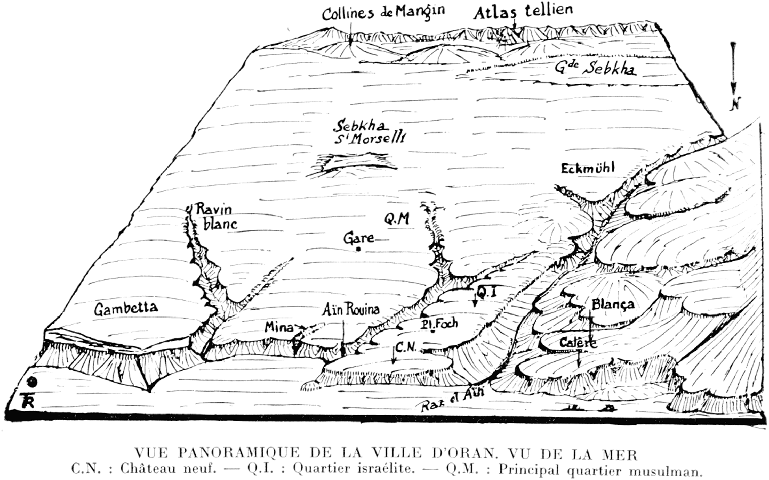
The construction of Oran’s Front de Mer Boulevard in the middle of the twentieth century, now called the Boulevard de l’Armée de Libération Nationale, 6 marked the moment when the sea became an identifying element of the city. Conceived as both an architectural and an engineering project, the Boulevard reshapes the image of Oran, characterizing it as a port city. It was the architect and engineer Emile Cayla who first proposed a Front de Mer Boulevard in his 1891 plan for the beautification of the city. However, the Boulevard was not fully realized until half a century later by the mayoral administration of Fouque Duparc, who adapted it to the guidelines of the 1936 Plan d’Aménagement, d’Extension et d’Embellissement PAEE 7 (Plan of Development, Beautification and Extension), prepared by the Danger brothers. The Front de Mer project represents a rebuttal to the Camusian criticism, 8 considered for a long time as an embarrassment for the city: ‘This boulevard, where Camus will be a “stranger” 9 tomorrow, surprised himself to have so much criticised this city, whereas deep down, he loves it perhaps too much!’ 10
This article sheds light for the first time on the construction history of this major work and on the challenges of its modernization and its forms, in the perspective of the twentieth century urban planning approaches. It should be noted that this research was conducted by extracting evidence from archival records.
In the context of Oran, the municipality implemented two simultaneous approaches for the Front de Mer project. Firstly, the image construction through the regeneration of the Oran waterfront; and secondly, the rehabilitation of the nineteenth century urban fabric. From this great initiative, history will remember the audacity and the scale of avant-garde urban projects, where two urban concepts, typical of the 1960’s, were developed at an earlier stage. This article will discuss these two concepts: the waterfront revitalization and deck urbanism.
The first concept comes from an urban planning practice born in the United States during the 1960’s. This phenomenon spread on a worldwide scale following successive generations of port redevelopments. 11 After the prolonged neglect of port areas, cities started to reconnect with their waterfronts. The ‘remaritimization’ 12 of the city through urban operations will become a key element in the identity and the image construction of Oran. This article does not aim to elaborate an exhaustive monograph on the transformations undertaken on the Oran waterfront from the end of the nineteenth to the middle of the twentieth century. Rather, it aims to provide a framework for considering the meaning of waterfront planning control at the beginning of the twentieth century, and its relationship to the waterfront revitalization movement.
The second concept, the deck urbanism, had its heyday in France in the 1960’s. The artificial platform, or ‘dalle’ in French, represents a technocratic vision of urban development induced by the industrial revolution. Instead of the traditional public square, the deck holds a new spatial organization. This new urban space with a vertical organization, aimed to separate pedestrian and vehicular flows. The Front de Mer projects appear as an early model of deck urbanism. In the process of modernizing the nineteenth century urban fabric, deck urbanism appears to answer here different urban planning issues, such as traffic, housing and beautification. The case of Oran is not a precursor; however, the developments of the waterfront projects present similar concerns and contain aspects that can be compared to what is observed in deck urbanism.
At the same time, this research commits to decompartmentalize the comparison between the countries of North Africa in a colonial situation and Europe, by opening it to a comparative perspective on the American scale. Indeed, the dynamics of the waterfront development with modern urban planning and high-rise buildings does not follow the tradition of the metropolitan model.
At the Regional Forefront of the Waterfront Revitalization Concept
The waterfront revitalization movement has an important place in urban strategies. This new trend seems to be adopted by the majority of modern port cities. 13 The North American phenomenon of the 1960’s 14 was initially adopted to describe post-industrial transformation of port infrastructure. 15 After being imported to Europe and Australia, it spread to the Maghreb cities through many operations, particularly in Casablanca, Rabat and Tunis. Later on, this movement extended to both Algiers and Oran. Algiers was concerned with the development of its bay, whereas for Oran, the concern was the development of the eastern waterfront. This latter operation was initiated by the Environment Directorate of Oran. However, these ‘megaprojects’, as they are called by the local media, are exceptional and outstanding compared to the other construction projects of the city. 16
In its intention to set up a new city-port interface, the Front de Mer of Oran project features as an early example of the waterfront revitalization movement in a colonial context, 17 similar to Algiers and the Bund of Shanghai. 18 Indeed, in the nineteenth century and with the expansion of world trade, colonial waterfronts became the most important image of a port city, namely, as ‘both a maritime business card and a welcome sign for travellers coming over the sea’. 19 Oran’s Front de Mer project aimed to change the image of the city in its relationship to the sea and the port at different scales. These changes integrate at the same time the socioeconomic and the urban mutations of the city’s early twentieth century urban and port space. Although the projects realized for the Oran waterfront did not have the same orientations as the waterfront revitalization, which originally concerned the transformations of port wastelands, clear convergences appear with regard to questions of governance, image and the restructuring of the urban-port interface.
The Image of the City under Construction in Emile Cayla’s nineteenth Century Project
Although Oran benefits from a privileged location on a plateau above the coastline, the city did not really develop a waterfront boulevard until the middle of the twentieth century. The construction project was episodic and intermittent, constrained for a long time not only by the obstacles of military establishments, but also by the topographical nature of the site (Figure 2). At the end of the nineteenth century, Emile Cayla (1841–1909), architect and civil engineer, was the first to propose a maritime boulevard for the city. This architect, who expanded into real estate speculation, belongs to that category of entrepreneur who took advantage of the disorganized land markets of the early days of colonization, during the second half of the 19th century, to undertake urban development projects.
20
At those times, this practice was encouraged by the Second Empire of France.
21
In 1891, when the city was financially unable to repurchase and transfer of the military lands,
22
Cayla proposed to the municipality a project entitled Les Embellisements d’Oran (The Beautification of Oran). In this project, he developed the very first plan for a waterfront boulevard, extending from Philippe Street to Gambetta suburb. This operation undoubtedly influenced the city’s future urban projects during the first half of the twentieth century. The Front de Mer Boulevard and the Cressonnière Ravine in the early twentieth century. Source: http://popodoran.canalblog.com/archives/2015/05/10/32035182.html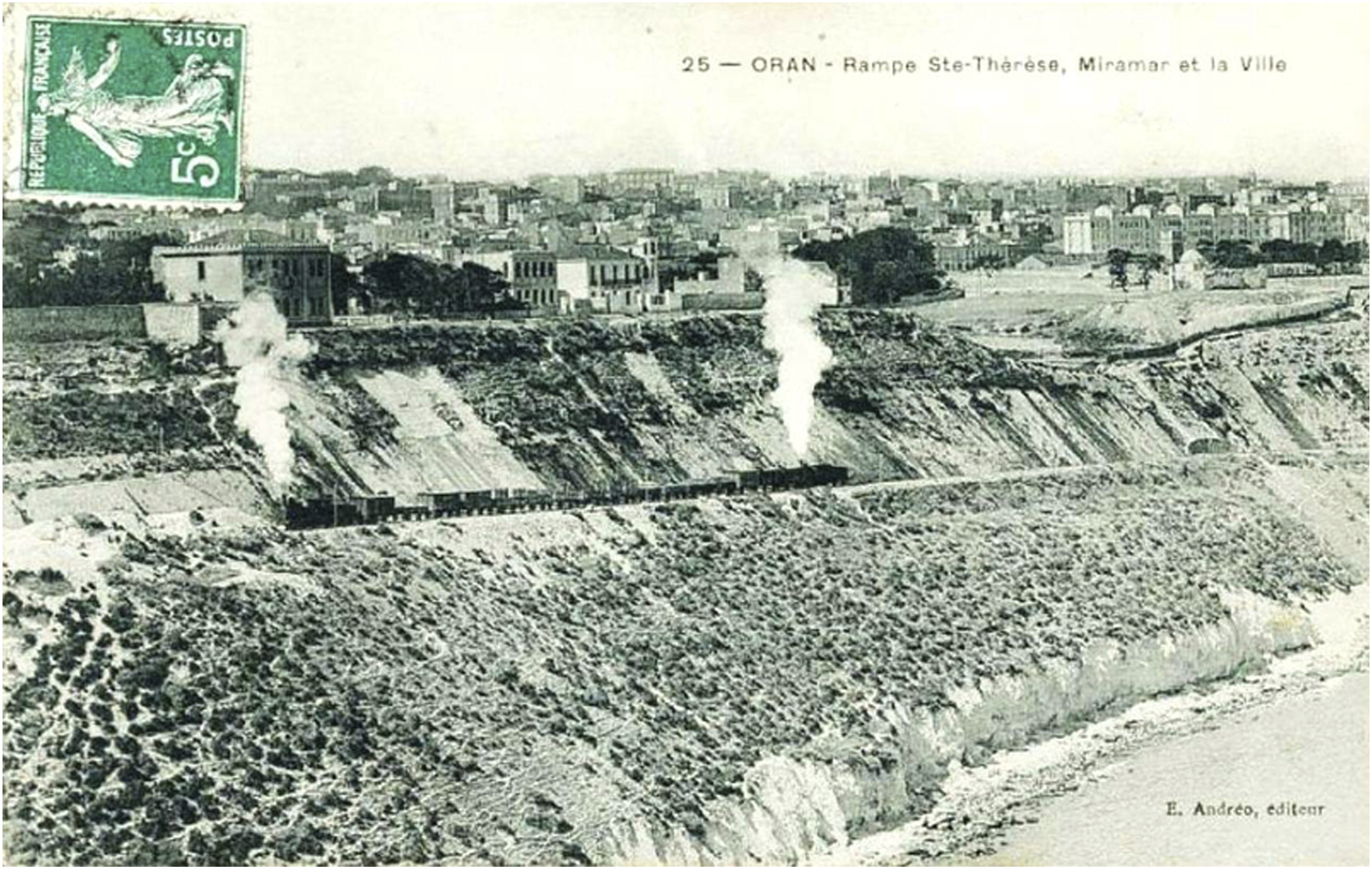
Temporarily called the Boulevard du Nord, in reference to the existing short stretch of road, 23 the project was centred on the Karguentah plateau. This military land reserve for a long time had hindered the urban development of the northern part of the city. Emile Cayla’s beautification plan marks the first intervention of a private initiative in urban development projects in Oran financed by a real estate company. 24 This approach was first used in Algiers in 1860 with the construction of the waterfront boulevard, known as the Boulevard de la République. These partnership initiatives between public and private actors, and the entrepreneurial urban planning approaches that they imply, define the origin of the Cayla project, in line with the experience in North American cities.
Unlike the Boulevard de la République in Algiers, initially designed for both strategic military purposes and to link the port to the city, 25 Cayla’s project for Oran was conceived as a project for the beautification and enhancement of the waterfront, following the example of the Promenade des Anglais in Nice. 26 The great perspectives of modernisation that Cayla undertook led his detractors to describe him as one who dreams to ‘become an Algerian Haussmann’. 27 Although Oran was a second tier city, Cayla believed that it has the characteristics and the potential of an American city: ‘Oran is not an ordinary city of Old France, nor even of its eldest daughter Algeria; but a city of the young and powerful America. It is therefore necessary to support its unlimited growth and to give it the framework that suits its future development! Oran forever! 28 Onward!’ While Algiers 29 and the rest of the Algerian cities during this first colonial period adopted the Haussmannian metropolitan model, Cayla presented a perspective turned towards the Americanization of cities. The American model is envisaged here as the territory of modernity in action, a development model that is being gradually imposed in Europe. 30 This allusion to Americanism was to remain topical during the construction of the high-rise buildings in the 1950’s. In fact, for Michel Coquery these buildings gave this part of the city ‘the appearance of a ... southern American city’. 31
Like the waterfront revitalization movement, which places the rediscovery and creation of a new identity at the centre of new urban practices, the Cayla waterfront project intended to redefine the image of the city. The construction of a maritime city image is reflected in Cayla’s plan, where he foresees a touristic and recreational development in the future. According to him, this road will become ‘the most frequented one in the sporting world’. His reference to a sporting vocation is undoubtedly in line with the trend of the European seaside resort cities of the nineteenth century, which transformed purely hygienic bathing practices into a recreational and tourist activity.
Moreover, Cayla’s project appears to resonate with patterns of spatial gentrification, a recurrent phenomenon of the waterfront revitalization movement. He plans the construction of villas, castles, recreational homes and manor houses along the Boulevard du Nord, where he intends to attract the wealthy citizens. He sets up what he called a ‘buen retiro’, an isolated place reserved for the city’s high society. The bourgeois character sought by Cayla, characterizes the seafront and thermal resort towns in France in the nineteenth century. There are still some manor houses on the western part of the boulevard, which illustrate this practice, notably the manor house designed by the architect Léon Blanc. 32
Despite its stated ambition to re-establish the relationship between the city and the sea, the Boulevard du Nord designed by Cayla does not stand entirely as a belvedere. The route abandons the segment of the waterfront over a length of 910 m,
33
from the Lamoricière High School to the existing Boulevard du Nord, following the direction of Paixhans Street and la Vieille Mosquée Street, along the district known as Quartier de la Mosquée.
34
Indeed, the image of a modern coastal city that Cayla wanted to inscribe came up against technical obstacles, which were the crossing of the Mina Ravine
35
and the need to circumnavigate the obstacle of the high school. It seems that Cayla resigned himself to deviate the boulevard from its waterfront for economic reasons. In fact, his first idea was to reproduce Algiers’ boulevard underneath the Létang Promenade by developing a raised boulevard over warehouses. However, this idea was discarded because it was too expensive. This solution, which initially aimed to link the upper and the lower town, is an implicit first attempt to connect the city to its port (Figure 3). His idea to reproduce the Boulevard de la République of Algiers represents also the first attempt to transfer the Chassériau ramp concept to Oran, and was implemented later in the following other projects. In fact, the Chassériau ramp configuration, which combines shipping and commercial functions with residential functions, constituted an urban reference beyond Algerian borders. The original design of the Chassériau ramp is cited, for example, by the authors of the New York regional plan of 1931.
36
The Boulevard du Nord in Emile Cayla’s beautification plan. Credit: ©F. B. ALLAL. Source: René Lespès, Oran: étude de géographie et d’histoire urbaines (Oran: Bel Horizon, 2003).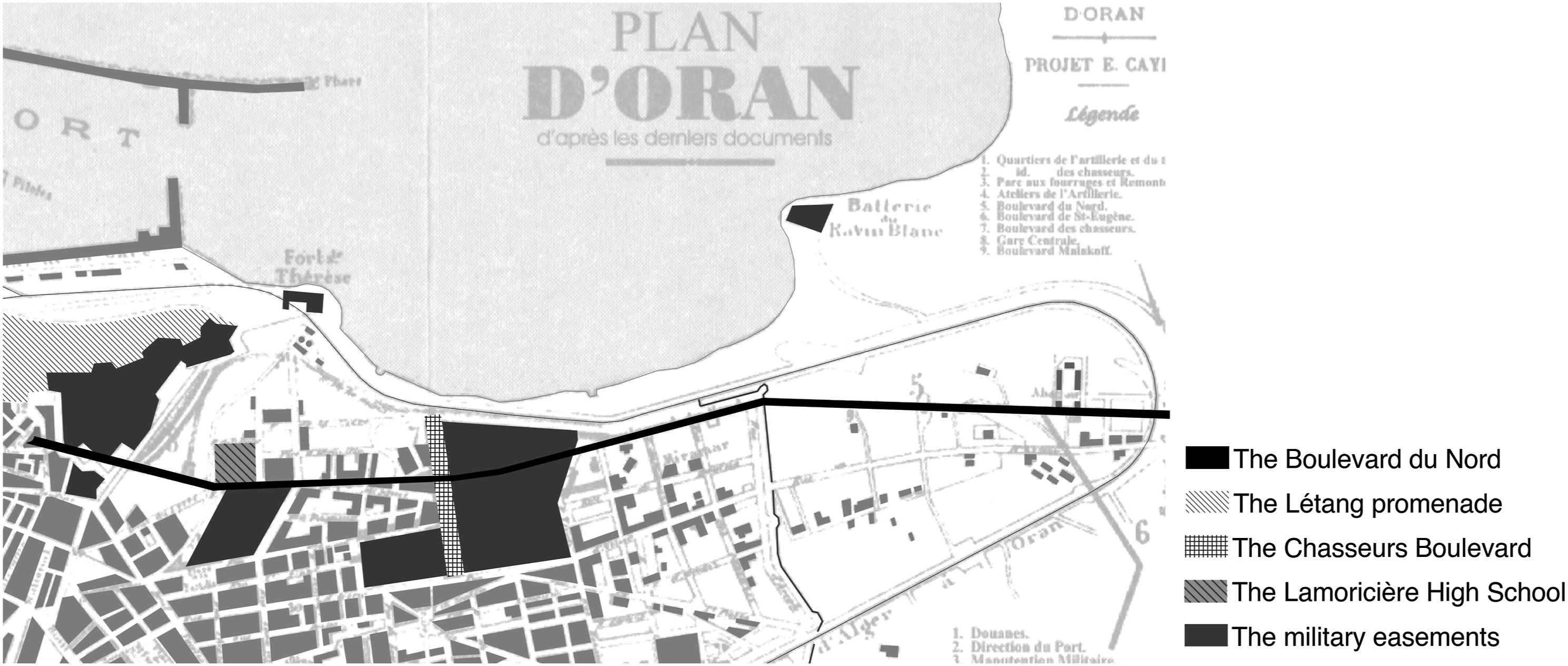
Synergies between Urban and Port Spaces in the First Half of the twentieth Century
Whereas the Cayla plan re-establishes partially the visual link between the city and the sea, later projects progressively develop a continuous belvedere boulevard, displaying explicitly an intention to link the city to its port. Despite the topographical distance between the city and its port, the Oran waterfront projects initiate a new city-port dialogue.
37
The ambitious urban project presented by the mayor Dr Jules Gasser
38
in 1912, illustrates this city-port dialogue. Unfortunately, this project was not carried out because of the outbreak of the Great War
Like the Cayla plan, the Gasser urban program also involved private actors in both the funding and the realization of the project. Germain, Manent et Cie, a company from Algiers, presented a preliminary project, with the condition that it would have the exclusive right to realize the program. Just as in Metropolitan France, since the nineteenth century, financial support is increasingly sought in urban planning operations, mainly from the real estate companies, where the banks play the role of financial backers. 40
For the development of a Front de Mer, Gasser proposed the exploitation of military and civilian structures for the construction of two new districts on the waterfront. The first is located on the high school site and the second on the Château Neuf site.
41
In an effort to reveal the waterfront, he planned to demolish the Château Neuf with the Cercle Militaire and the high school.
42
These were the main obstacles encountered by Cayla in his project for a continuous boulevard. In brief, the concession of these facilities not only created a continuous maritime boulevard, but also established a better relationship between the town and the port. A reading of the illustration produced by Germain, Manent et Cie (Figure 4) provides information about the development of the seafront, starting from the upper town to the quartier de la Marine, a district near the port. Thus, the new districts create a new city-port interface and open up the city to the sea. An illustration of the Gasser program-report. Source: ‘Oran et son histoire’, L’Afrique du Nord Illustrée, Oran special issue (April 26, 1913): 9, Bibliothèque nationale de France, gallica.bnf.fr.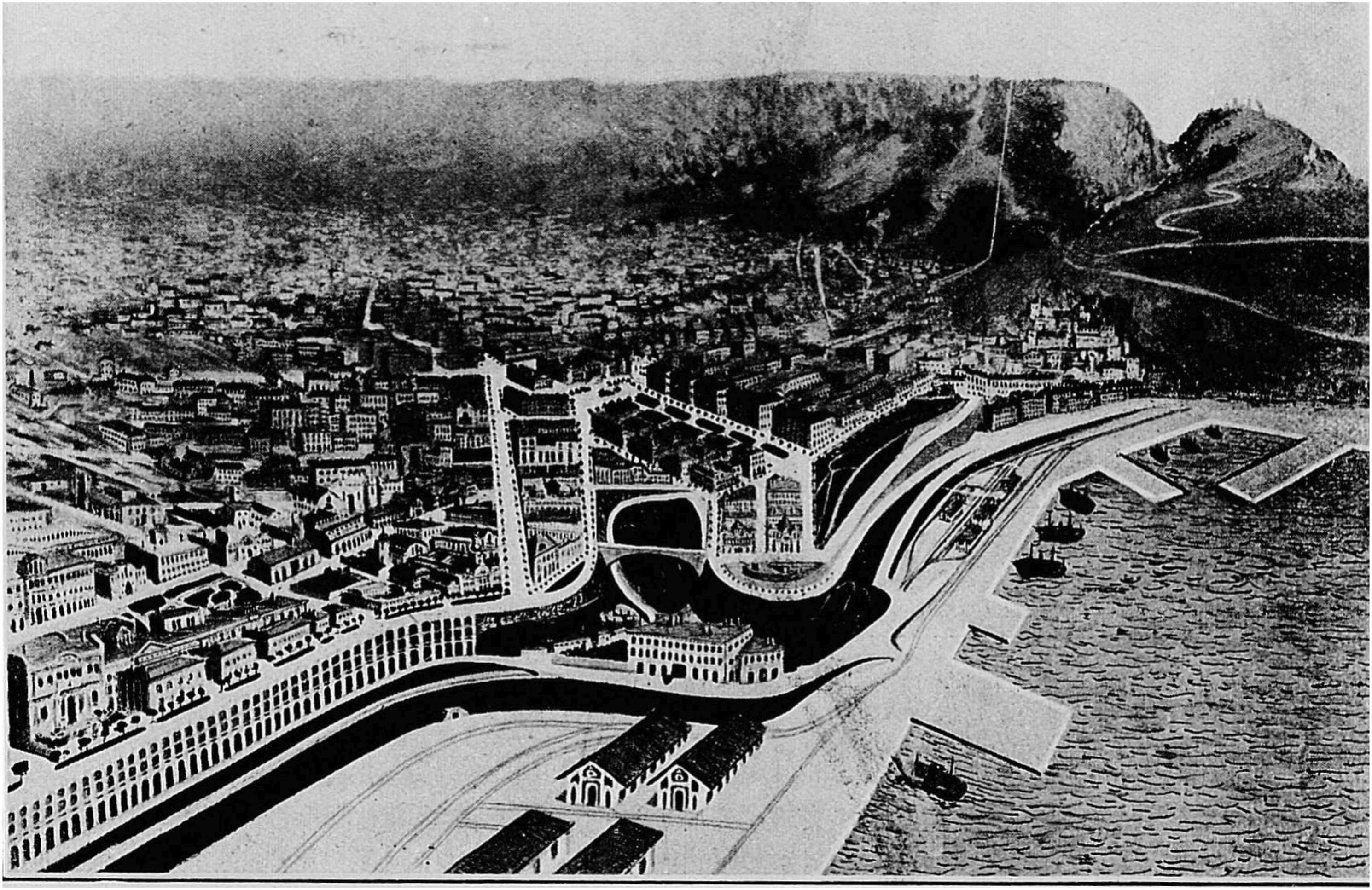
However, it was not until the PAEE project that the current layout of the Front de Mer Boulevard was defined. The PAEE of Oran, launched in 1936, was the result of a collaboration between the Danger brothers and the DPLG 43 architect Georges Wolff. As underlined by Jean-Pierre Frey, 44 one of the particularities of the PAEE of Oran was the integration of ideas from previous plans and adapting them to the current situation. Unlike these previous projects, and far from obstinately wanting to ‘capture the imagination with beautiful images and grandiose projects’, 45 the PAEE was presented as a feasible project, avoiding the continual postponement of its execution for technical and financial reasons. Nevertheless, the PAEE proposed a variant project in the case of a possible transfer of the Château Neuf and a relocation of the high school. 46 Considering the topographical character of the city, perched on the cliff and overlooking the sea, the physical reconnection with the port is for the first time envisaged vertically. Indeed, above the filling of the Ain-Rouïna Ravine, a footbridge and elevators are planned to directly link the upper districts to the docks and the maritime station.
This city-port relationship was reassessed in a project carried out by Emile Lucien Cayla’s
47
in the 1930’s. This engineer from the Arts and Manufactures was also an eminent architect from Oran, taking over his father’s beautification plan.
48
Emile Lucien Cayla conducted this project within the Syndicat d’Initiative des Habitants des Quartiers Neufs
49
(Union of the New Districts Residents’ Initiative), an organization that he founded in 1933. The Front de Mer Boulevard represents the very core of the plan (Figure 5). The architects within the Union designed a new framework of connections between the city and the port area while generating new urban grids for the establishment of new districts. Similar to the town planning projects of the nineteenth century, such as Haussmann in Paris and Cerda in Barcelona, the Union’s architects considered the traffic function at the heart of the urban transformation. The relationship between the port and the city in the Syndicat d’Initiative des Habitants des Quartiers Neufs project.Credit: ©F. B. ALLAL. Source: Chantiers, no. 7 (July 1936): 370–371, Bibliothèque nationale de France, gallica.bnf.fr.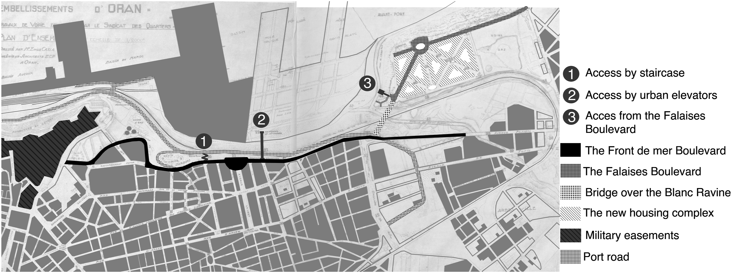
The waterfront boulevard extends from the Vallès ramp to Gambetta suburb and initiates a new city-port relationship. Unlike previous projects, the access to the docks does not directly connect the upper part of the city to the lower part. Rather, it cuts across the cliff through vertical connections, a technical solution that overcomes the topographical constraints of the cliff, while avoiding the relocation of the Château Neuf and the high school.
From the boulevard, three access points to the port were planned. The first is a reinforced concrete staircase located between the Chasseurs Boulevard and the port road. The second encompasses urban elevator and freight lifts linking the port to the new districts through a footbridge connected to the Laurent-Fouque Boulevard. A third connects the Gambetta suburb to the port by urban elevators and a freight lift from the Falaises Boulevard. This boulevard is sketched out at the front of the Gambetta cliff and is linked to the Front de Mer Boulevard by a bridge over the Blanc Ravine. Furthermore, and anticipating the potential land value of the Front de Mer project, the plan initiated by the Syndicat d’Initiative des Habitants des Quartiers Neufs envisaged the development of a new ‘first-rate’ 50 district encompassing 135 buildings erected along the Falaises Boulevard. The landscape of this new district, with buildings facing the sea, wide avenues and punctuated by parks and squares, gives to the waterfront an image of a modern city. 51
In the late 1950’s, SOGEP Perret Company
52
proposed a real estate development project ‘Le Belvédère’ located on the seafront. This project confirms the posterity of the urban issue of a city-port relationship. The advertising flyers published by the real estate development company (Figure 6) reveals the integration of a partial waterfront development plan, heavily influenced by the previous projects. The Parisian design studio CETBA, in charge of this project, planned to demolish some parts of the Château Neuf, in order to create a green space and a boulevard overlooking the sea. On this boulevard, a footbridge designed above the Létang promenade, connects directly to the port by an urban lift. Development of a city-port connection within the Belvédère plan. Source: Advertising brochure for the Belvédère project by the SOGEP Perret and SOARI firms.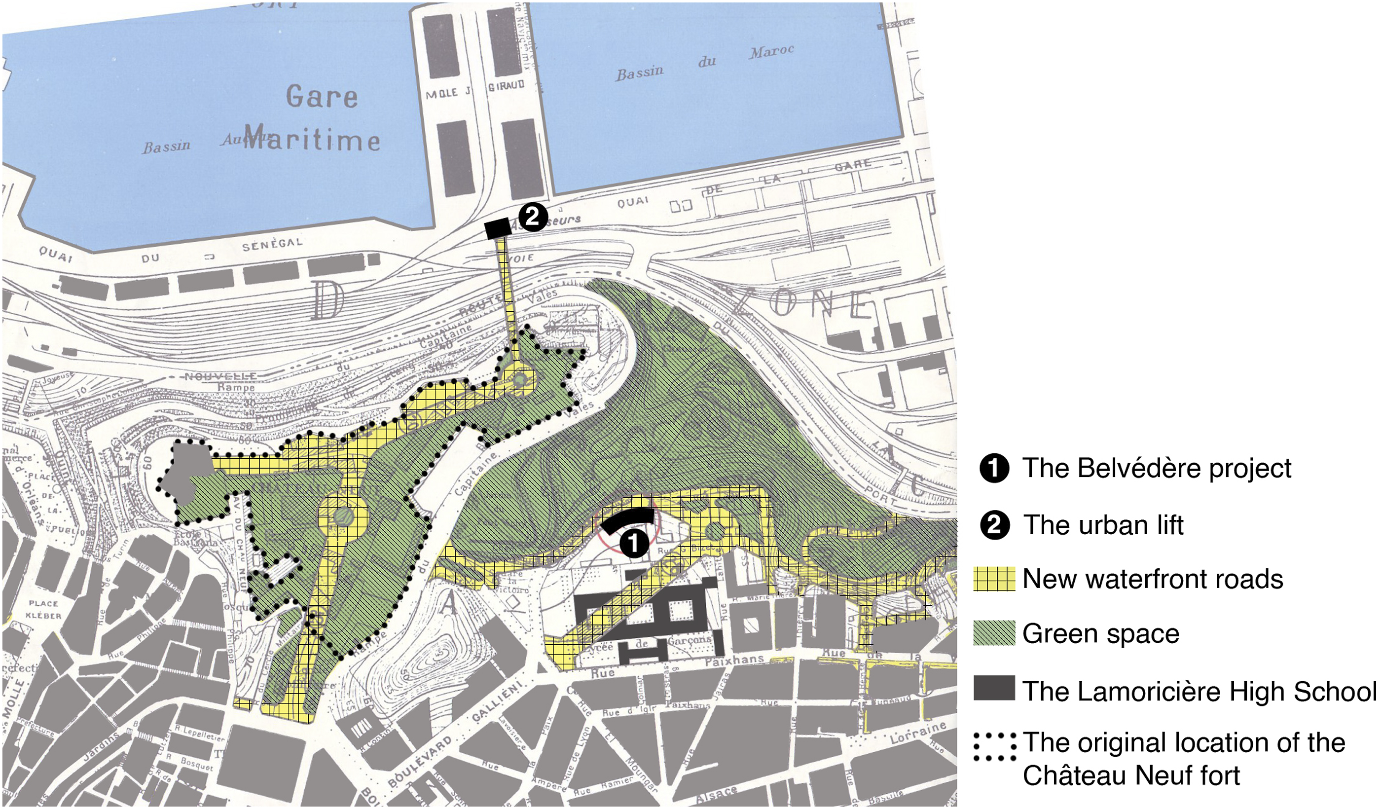
The Front de Mer of Oran, an Early Example of Deck Urbanism?
In Oran, the dynamics of the Front de Mer project engages discussions on the modernization of the urban spatial order and its adaptation to the changing functions of the city. The topographical characteristics of the maritime cliff, punctuated by its three ravines, led to new views and decisions about their exploitation for the development of vertical urbanism. In fact, the successive Front de Mer’s projects present concerns comparable to those of the deck designers. The ravines were progressively drawn on to adapt them to a vertical urbanism and to a real separation of functions and traffic flow.
Between 1950 and 1975, following the process of cities’ modernization, France conceived and proposed deck urbanism projects, also called platform urbanism projects. Considering urban organization vertically, the deck establishes a superposition of the different circulation systems. The ground it created is designed for pedestrians, whereas the lower levels are assigned for different types of flows (means of transport and technical networks). According to Marc Wiel, 53 the deck is an approach that brings together two opposite visions of the city: the culturalist and the functionalist ones. It represents an example of the new relationship between city and architecture, imagined by the architects of the pre-war modern movement. 54 According to Virginie Picon-Lefèbvre, 55 the deck designers were also inspired by American theoretical proposals for the city of the future that were widely disseminated by the media, such as that of Hugh Ferris or the Futurama of Bell Geddes. This theory of traffic flows separation will resonate in France in several examples, such as the city centre of Choisy-Le-Roi, Mériadeck in Bordeaux and La Part-Dieu in Lyon. However, the most emblematic examples are the Parisian ones, such as Maine Montparnasse and la Défense 56 district. The first illustrates an example of urban transformation within the city of Paris, whereas the second is on a larger scale located at the periphery.
The Ravines of the Front de Mer in the Infrastructure of Oran Vertical Urbanism
The topographical particularity of the land on the cliff overlooking the sea and alternating with ravines, presents an urban potential for the authors’ of the Oran’s waterfront projects. The exploitation of the ravine cavity offers possibilities for stratification of spaces while responding to the problems of mobility and accessibility. The Boulevard de la République in Algiers will have a very special impact and contribute gradually to develop the idea of a vertical organization along the seafront.
In this context, it appears that Gasser’s urban program refers to the example of Algiers, through the design of ‘huge’
57
warehouses occupying the Mina Ravine. Although Gasser’s report places the warehouses only on the ravine, the relief model produced by the Germain, Manent et Cie company shows a long, continuous viaduct boulevard, with a vaulted construction, similar to the Algiers’ project. Although disproportionate, this operation indicates the intention towards a vertical urban development exploiting the topographic situation of the boulevard. In 1936, the Syndicat d’Initiative des Habitants des Quartiers Neufs took up this idea to develop the potential of the ravines, focussing mostly on its feasibility rather than the spectacular effect. The associated architects Malhonda and Garagnon, proposed to develop on the Cressonnière Ravine, under an artificial floor, a multifunctional project for sports, leisure and tertiary spaces distributed over three underground levels (Figure 7). They took advantage of the ravine’s cavity to make the underground space useful, a form of urban organization at the crossroads between deck urbanism and underground architecture. The project presents a complex cover deck distributing the activities by levels. The vehicular and the pedestrian traffic flow are separated by setting the parking lot and the bus station in the second basement. The remaining space is reserved for underground leisure activities: cultural and sport infrastructures, a library with reading and conference rooms, three hot water swimming pools and a gymnasium. In the square, on the surface of the deck, the project turns to aquatic activities, with a large outdoor swimming pool. The development of Montreal and the other American cities from 1960 onwards testifies to the interest shown later to this type of underground development. The underground layout of the Malhonda and Garagnon project. Source: Chantiers, no. 1 (January 1937): 56, Bibliothèque nationale de France, gallica.bnf.fr.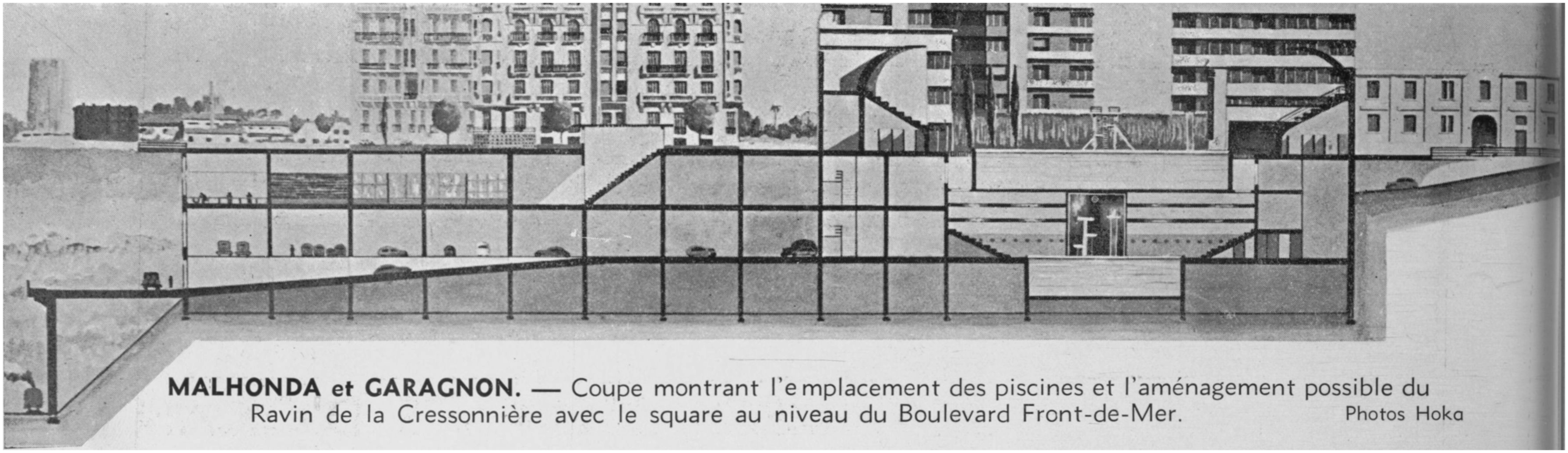
The Bay of Oran on a Deck: The Utopian Project of Ciliberti
The various Front de Mer plans attempt to exploit the topography of the site to create a vertical planning. A consideration that led to an experimental project, featuring the ultimate state of separation between functions and traffic flows through a deck. In 1937, the Syndicat des Architectes du Département d’Oran (The Union of Oran’s Architects), led by Emile Lucien Cayla, 58 organized the first exhibition of modern architecture and urban planning in Oran. 59 The DPLG architect Ciliberti Nonce stands out by presenting a new urban-port space built on what he called an ‘artificial platform’. While the previous projects were concerned with the development of a boulevard on the seafront, Ciliberti’s project proposed a new maritime interface for Oran, without any relation to the previous forms of the city, and more adapted to future uses and practices. Probably influenced by Le Corbusier’s 1933 Obus plan for Algiers, Ciliberti presents an urban project that develops a utopian vision of the city. Although the configuration is not the same, the idea of a project that can resolve the problems of a modern city on a waterfront, while integrating vehicular and pedestrian infrastructures at the same time, is effectively comparable to Le Corbusier’s project. 60 Ciliberti’s idea was to create a new space resting on a reinforced concrete platform above the Bay of Oran. He planned to separate the vehicular and the pedestrian traffic flow and to introduce the airplane as a new means of urban transport.
In the spirit of the modern urban projects that influenced the deck planners during the 1960’s, 61 Ciliberti imagines a paradigm of the future commercial city adapted to the new means of transport. He suggests a future switch from the automobile to a tourist airplane and autogyro. For this architect, Oran represents an important commercial centre, a link between the southern and the western territories. Therefore, Oran must be at the forefront of technological development, and should be equipped with an intercontinental tourist air station and a ‘hydro base’. He previews here the monopoly of what he calls ‘air liners’ over the old transatlantic liners.
In a city that he considers ‘poorly constructed, a failed city, the one that did not know how to make the most of its natural beauties’,
62
Ciliberti’s project re-establishes different viewpoints towards the sea from which it ‘derives all its beauty and profit’. He designs a large platform of 260 ha at 66 m above sea level, to create a space suitable for an aerial station, without having to demolish half of the city (Figure 8). This deck, located at five meters above the Place d’Armes, steps down to the level of the Létang promenade. Then, it continues horizontally to the harbour pier, supported by reinforced concrete pillars placed at every one hundred metres. The upper level of the platform is reserved for pedestrian traffic and for residential and tertiary functions. The Ciliberti plan. Credit: ©F. B. ALLAL. Source: Chantiers, no. 1 (January 1936): 60, Bibliothèque nationale de France, gallica.bnf.fr.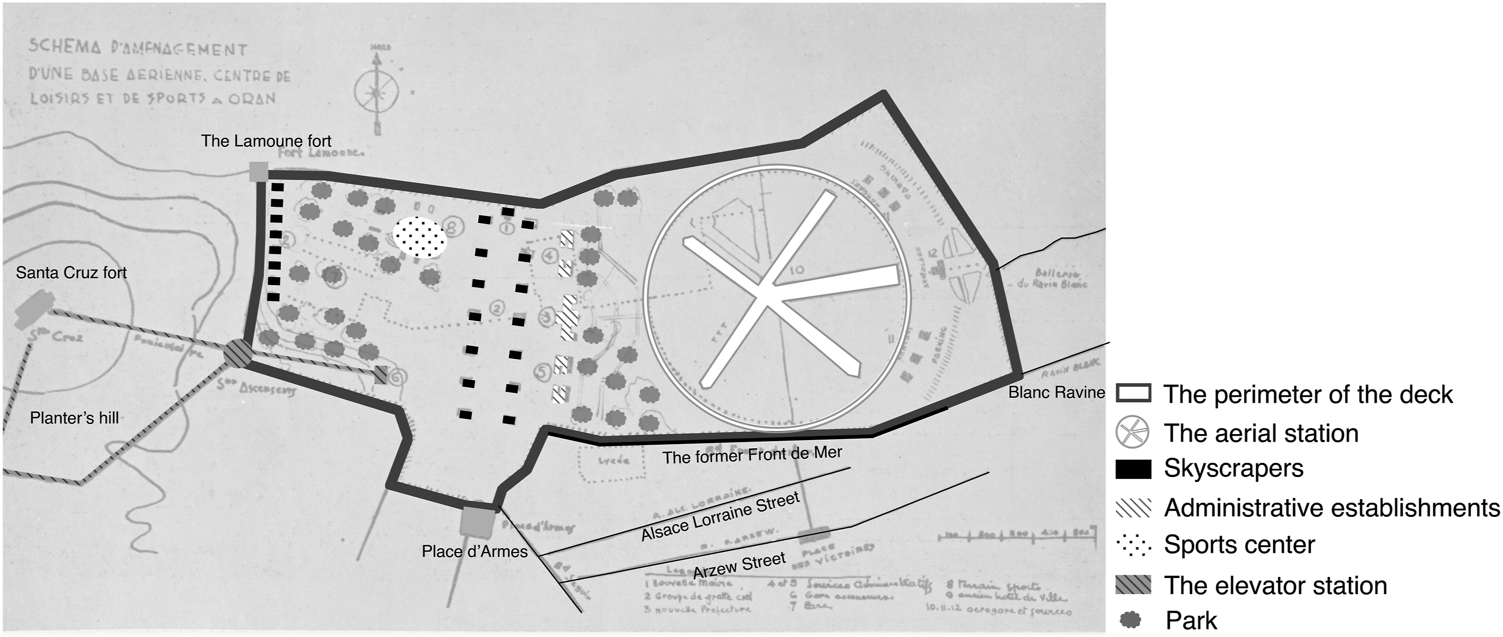
Underneath the platform, the vehicular traffic and the underground military facilities, specific to the war context of the time, are arranged in superimposed floors. In addition, there is an underground shelter for protection against attack by sea and air, as well as warehouses for the storage of food and fuel to supply, not only the city, but also the entire Oran region to withstand a siege. Vertical circulation is emphasized with a series of elevators and a funicular railway, called the Elevator station, leading to the new residential area designed for the high society on La Colline des Planteurs (the Hill of the Planters). In addition to the urban space free from vehicular constraints, he also establishes a new city-port interface. With his idea to promote city tourism in the future, Ciliberti proposes not only modern and exceptional urban functions with an air base ensuring multimodality with sea, land and air connections, a leisure and sports centre, but also first-rate administrative establishments (Prefecture, Town Hall, tertiary services).
The deck is also seen as a real estate opportunity for the development of a new housing complex. The building type is not arbitrarily decided, Ciliberti opts for skyscrapers, the archetype of American architecture (Figure 9). Indeed, the conception of the project with the new vision of mobility, the fascination with mechanization and the tall building design seems to be affiliated with the development of American cities. As stated by Philippe Boudon,
63
this modernity is a matter of scale. Below the deck are located the seaplane base and the traffic of the port. Ciliberti considers that the port will promote a maritime tourist activity. The ‘mise en scène’ of the modernity and the singularities of the city on the waterfront manifest a new metropolitan image of the city, described by Rachel Rodrigues-Malta as a new metropolitan showcase.
64
Perspective of the Ciliberti urban project. Source: Chantiers, no. 1 (January 1936): 60, Bibliothèque nationale de France, gallica.bnf.fr.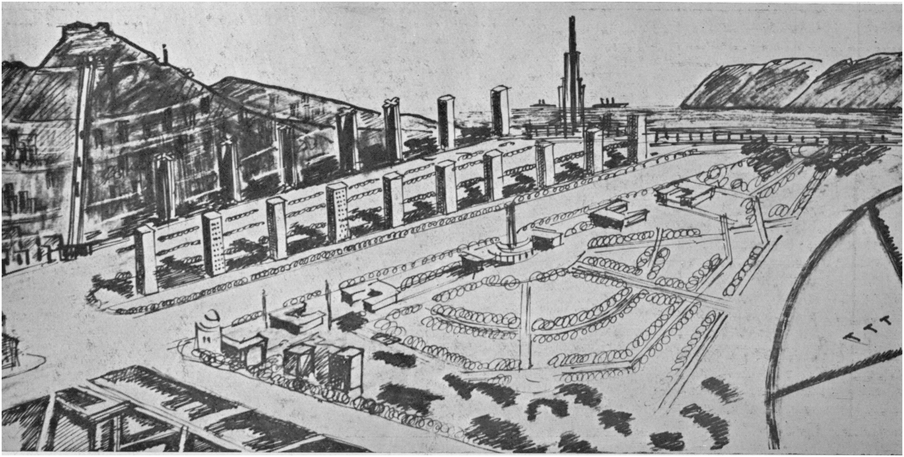
The Functional, Technical and Aesthetic Completion of the Front de Mer Project in the 1950’s
In the mid-1930’s, the city architects launched an appeal through the Syndicat d’Initiative des Habitants des Quartiers Neufs, in order to hasten the completion of the Front de Mer project. They declare in a note published for this purpose in the journal La Vie Municipale that ‘It is painful to see that this boulevard, which has been under study for 43 years, has not yet been completed. Everyone who came to this place, including tourists, do not understand how we did not know how to take advantage of this unique situation of a boulevard which would be the real jewel of Oran and which would contribute powerfully to the embellishment of a city that needs it so much’. 65
In 1950, just before the construction of the project, the lack of a proper seafront reinforces the negative image of the city in the public opinion. The journal Les Travaux Nord-Africains echoes this feeling shared by Oran’s people, who ‘like to criticize “this failed city” pushed into the worst of sloppiness, without any concern to take advantage of the admirable site offered by its steep topography’. 66 However, the initiation of the project will change the opinion of Oran’s people on the perceived image of their city. In 1953, the journal Les Travaux Nord-Africains publishes another article, to present the new image of the city, transformed by the Front de Mer project: ‘It’s quite a metamorphosis, and almost undergone, under the influence of a new vocation’. 67
The Front de Mer project carried out during the 1950’s, under the governing mayor Fouque Duparc, 68 followed the directives of the PAEE. It presented an accurate translation of the ideological approach initiated at the end of the nineteenth century, in consonance with the reality of socioeconomic and technical context. In a more general way, it considers the traffic issues, the integration of housing, trade and services, and the relationship between the city and its port. It focuses mainly on the development of the ravines, starting with the Cressonnière. Unlike Garagnon and Mahonda’s project, the cavity of the ravine did not serve for the construction of a deck. Instead, the ravine was backfilled and crossed by a tunnel under the new square, forming a link between the Miramar district and the port road.
The Mina Ravine was built during the second phase of the project launched in 1956;
69
it made a successful use of the unevenness of the land by use of a column structure and a bridge building. The ravine is crossed by a 300 m long reinforced concrete viaduct, from the Chasseurs Boulevard to the Charles Gounod Street, with a 6.20 m cantilever over almost the entire structure (Figure 10). The cavity of the ravine is used for the construction of a bridge building. This idea seems to be inspired by the warehouses below the boulevard in the Gasser project. Erected on either side of the bridge over Mina Street, the viaduct deck forms the roof of the bridge building. An intermediate floor supported by the viaduct piers represents its floor. It should be mentioned that the housing function is not planned, because of the single facade orientation. Construction of the viaduct over the Mina Ravine in the mid-1950’s. Source: http://popodoran.canalblog.com/archives/2015/05/10/32035182.html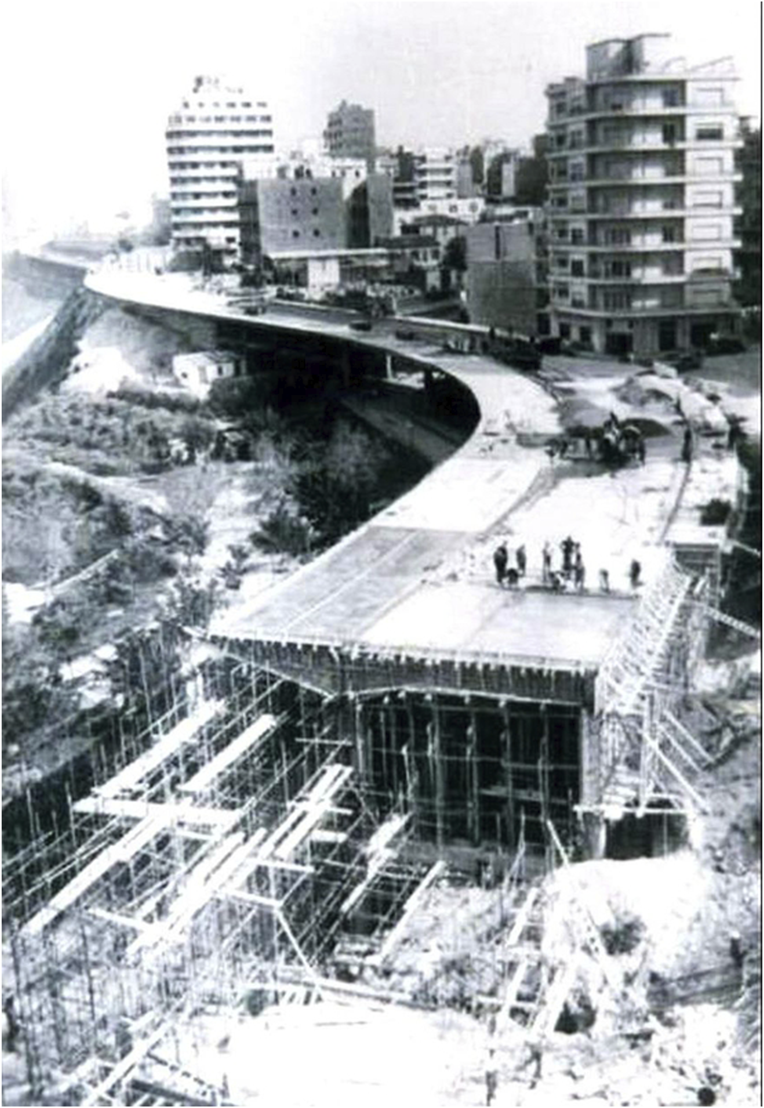
The construction of this cantilever boulevard at 60 m above the sea and on marlstone ravines, required the use of the latest technological advances in terms of deep foundations, implementing a new process of deeply driven piles using Les Pieux Franki technique, to cope with the unstable and permeable nature of the soil. Completed in 1957, 70 the foundations of the boulevard were composed of 160 Franki piles, each carrying an average load of 50 tonnes and dug to a depth varying from eight to 16 m to reach the bedrock.
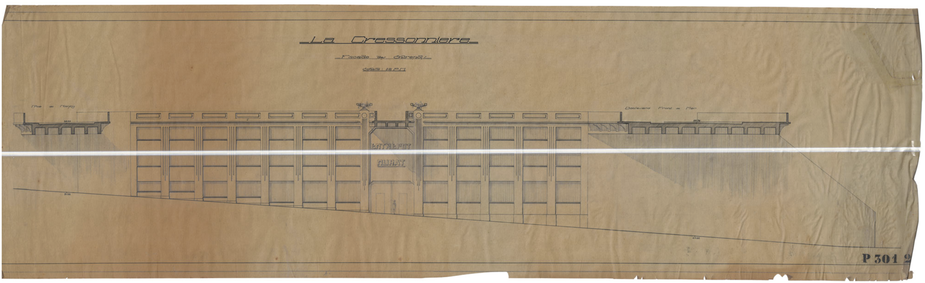
The research of the unpublished archives of the Division of Urbanism and Planning of Oran (DUP) reveals the full extent of the Mina and the Cressonnière Ravines projects. Although these archives demonstrate the extent of the impact of the previous projects of Cayla and son, Gasser, Malhonda and Garagnon, they have remained unknown to this day. A review of these primary sources shows that the Mina Ravine bridge building should have been larger than it is from Sainte Thérèse Street to Charles Gounod Street (Figure 11). They also reveal the existence of warehouses below the boulevard, on the Cressonnière Ravine (Figure 12). The role of French engineering in the production of the Front de Mer’s landscape demonstrates how infrastructure was central to the making of urban modernity. In recent years, scholars
71
have indeed shown the epistemic dimensions of the coloniality of infrastructure, where infrastructure plays an important role in the coloniality of power. Bridge building project below the Mina Ravine. Source: Archives of the Division of Urbanism and Planning of Oran (DUP). The Cressonnière Ravine project. Source: Archives of the Division of Urbanism and Planning of Oran (DUP).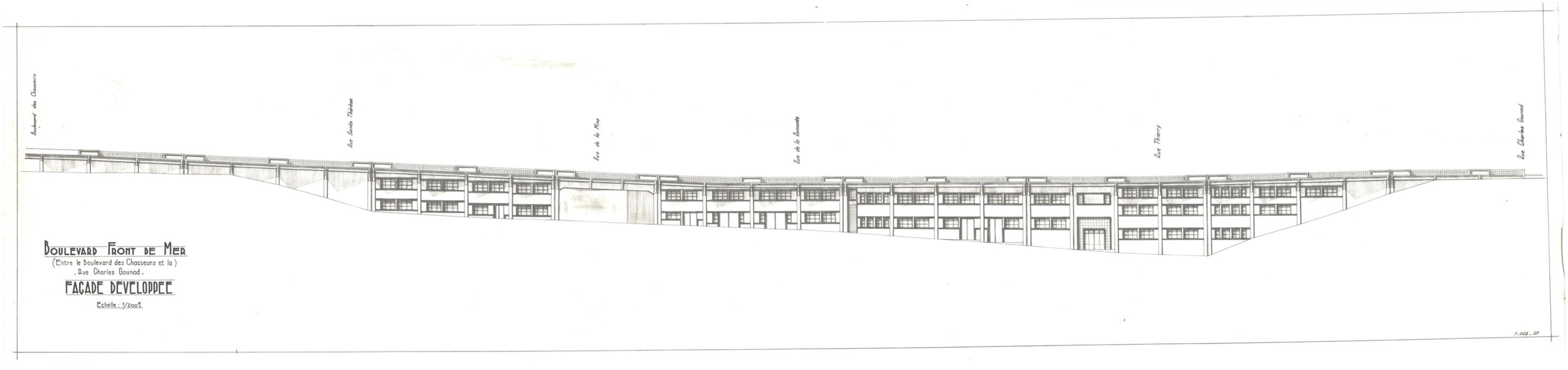
Conclusion
The waterfront strategy has held an important place in Oran’s urban planning projects from the end of the nineteenth to the middle of the twentieth century. To establish the image of a metropolis, the planners have proposed the most innovative designs and avant-garde models specific to the urban planning of the 1960’s. Beyond the urban answers to the dysfunctions of the city (traffic problems, connection between the upper and lower towns), the projects aim to build an image of an attractive metropolitan port city. As shown in the analysis of the different projects, the local authorities and developers have often pursued common interests in the control of the city’s image through the development of its urban waterfront. This particular situation places the Oran’s Front de Mer project in an early form of the American movement of waterfront revitalization. Although there is a topographical distance between the urban space and the port infrastructure, the planners proposed to connect the city to its port through physical links. Today, despite these development initiatives, the city centre is still not really connected to its port. It is to note that between these two entities, only one physical connection is realized in 2019; the Direction of Transport realized an urban lift, connecting the Front de Mer west end to Oran’s port. The anchoring of this urban issue in time reveals the lasting impact and posterity of these planning dynamics.
With regard to these facts, this study considers that the historical analysis of Oran’s Front de Mer can play an effective role in strengthening the future development of the city. It can both promote the adoption of a joint city-port plan and help to balance the different interests and goals. 72
In addition, the waterfront projects in their exploitation of the topography of the site seem to be infused with the American urbanism concepts of rationalization and mechanization of the city, similarly to the projects that influenced the deck urbanism. The great urban planning operations on decks in Metropolitan France were largely influenced by the American experience. This process of Americanization was amplified by the circulation of knowledge, images and the travels of French architects to the United States. 73 For example, La Défense project in Paris in the early 1960’s quickly became a model of Americanization in architecture. This process can be defined as the interpretation or appropriation of American forms in the architecture and landscape of a city. 74
The urban modernization system that has been implemented raises questions about the singularity of the Oran example compared to that of the capital Algiers. At a time when their counterparts in Algiers were still immersed in the urban planning model of axial alignments and nineteenth century Haussmannian aesthetics, Oran’s architects were experimenting modern forms of urban planning. The innovation of the urban plans that were drawn up for the city, allows us to place the debate on the confrontation of the experiences in Algiers and Oran in the duality ‘Algiers laboratory of architectural modernity’ against ‘Oran laboratory of modern urbanism’. Urban modernity is considered here from the angle of functionality and the intelligent use of topography, which requires innovative infrastructures and technologies. The Oran project refers to a modernity synonymous with rupture and nourished by new models. The aspirations of this modernity seem to be positioned as an issue of image definition and identity representation. As Jean-Louis Cohen 75 underlines, the actors of the colonial scenes knew how to claim these distant polarities with the aim of consolidating their own symbolic capital.
Several factors explain the unique fate of the Oran waterfront. The position of the military installations on the front of the plateau had obstructed urban development for a long time. But at the same time, it had constituted land reserves in the fabric of the nineteenth century city, offering architects new opportunities for creativity and innovation. Before 1936, this phenomenon was amplified by the delay in the implementation of regulatory urban plans. Moreover, due to the constraints of the inherited Spanish and French military installations, Oran was one of the last cities in the north of Algeria to benefit from a coherent urban plan. The process of deferred urbanization offered Oran’s architects opportunities for the urban reconfiguration of the nineteenth century city.
Finally, this first portrait of the Front de Mer reveals that the relationships between the public policies and the owner of the project have played an important role in the project implementation and orientations. In this context, the members of the Cayla family appear to have been the real actors and shapers of the Oran’s waterfront. They have led the transformation of the nineteenth century city and have headed the organizations behind the innovative plans for the waterfront. In fact, by their initiatives and proposals, besides the spatial, the constructive quality and the innovative character of their projects, they have marked the construction of an urban modernity in Oran.
Footnotes
Declaration of Conflicting Interests
The author(s) declared no potential conflicts of interest with respect to the research, authorship, and/or publication of this article.
Funding
The author(s) received no financial support for the research, authorship, and/or publication of this article.