
Abstract
The visualization of nature in cities fundamentally impacts how we imagine the urban environment and our role in caring for it. Across Australia, the project of urban renewal imagines and designs specific typologies of urban nature. These typologies can obscure grass root forms of environmental stewardship and their connection through civic ecologies. Yet, at this time of environmental change, residents’ engagement with urban ecologies is vital. What role might visual communication play in helping to make these civic ecologies initiatives more legible? This article discusses an experiment creating photo diagrams, which expands visual methodologies used in place-based research, such as photo documentation and visual ethnography. Iterative photography augmented by ethnographies enables us to ‘read’ the landscape. Diagrams support us in expanding the photographs in three crucial moves. First, desaturation reveals examples of civic ecologies. Second, tracing exposes the networks and relations that constitute them. And, third, text and lines of flight draw out how civic ecologies extend beyond specific sites and connect to other places. In this way, this article makes three contributions. The first is to experiment with ways to make grass root civic ecologies legible in their complexities to recuperate practices marginalized by top-down socio-ecological processes of urban renewal. The second proposes photo diagrams as a medium moving between photography as descriptive documentation and documentation of non-representational dimensions. Finally, the third brings a visual communication perspective into debates on conveying the non-representational in visual form.
In Australian geographical imagination – how we understand and represent the world, our and others’ place in it (Amin and Lisiak, 2022; Gieseking, 2017) – cities are often opposed to ‘the bush’ and, as an extension, to ‘nature’. The imagined disconnection between the city and nature is exacerbated by forms of urban renewal that develop deindustrialized areas into high-rise and high-density precincts, making urban ecologies illegible. Meanwhile, academic debates in urban political ecology (Heynen et al., 2006; Swyngedouw, 2015), geography (Gandy, 2022; Hinchliffe and Whatmore, 2006) and environmental humanities (Christensen and Heise, 2017) in the past two decades have highlighted the necessity to rethink and reimagine the nature of cities and nature in cities and to understand urbanization as a socio-ecological process.
This article brings a visual communication perspective at the intersection of these two discourses, exploring how we can make all manners of urban natures legible as socio-ecological processes. In this way, we make three main contributions. First, we add a different point of view to the understanding of socio-ecological processes in urban renewal areas by focusing on existing but marginalized local ecological practices (civic ecologies). Second, we propose the concept of photo diagrams to make present and legible these local ecologies as processes and relations between humans, non-humans and places. Third, we offer a visual communication perspective on current debates in geography and social sciences on how to address in visual methodologies the non-representational concerns with non-human agency, and intangible and invisible qualities of a situation (Rose, 2022: 329–335).
We situate our research in an area of urban renewal in Sydney characterized by high-rise and high-density development, and planned construction of green areas. Green corridors between buildings, pocket parks and green playgrounds designed and tended to by corporate gardening companies in private spaces and municipal workers on public land contribute to erasing other forms of engagement with urban nature. They also create a visually homogeneous verdant landscape to the detriment of longstanding, grass root environmental stewardship practices. We refer to these latter practices as civic ecologies (Krasny and Tidball, 2015): deliberate and intentional ecologies born from stewardship actions that articulate civic and environmental values. Our own examples of photo diagrams demonstrate the possibilities of visualization to form and consolidate civic ecological processes themselves.
Civic ecologies include grassroots initiatives outside the scope of urban planning, such as community and home gardens, native plant regeneration projects, or footpath gardens. Because they lack signposting and are often small in scale, civic ecologies can be difficult to recognize as an urban socio-ecological process. And yet, in an environmental crisis, all forms of urban ecologies matter. In particular, civic ecologies open up the possibility for city residents to engage and connect with urban nature or, in other words, to make cities in concert with nature. However, in areas of urban renewal, civic ecologies remain illegible.
We regard the illegibility of the urban environment as a visual communication issue: people cannot notice, read, appreciate and connect with the local civic ecologies in their everyday lives.
We use the term urban and civic ecologies (and environment) illegibility to move away from the disability metaphor of blindness, introduced in relation to plant life as ‘plant blindness’, to define the inability to see or notice the plants in one’s environment (Wandersee and Schussler, 1999). This move is not simply an attempt to rename a term critiqued as ableist (Parsley, 2020). Illegibility as a concept also gives us the opportunity for a redirective practice (Fry, 2007, 2014). Unlike ‘blindness’ and ‘invisibility’, ‘illegibility’ can redirect how we visualize the urban environment and prefigure urban ecologies to come. If something is illegible, we can develop literacies to make it readable. We can spotlight, illuminate, visualize, animate, focus and make legible the elements of urban ecologies in cities that tend to be otherwise unrecognized. We can recuperate everyday stewardship practices enmeshed in the urban fabric that are overlooked in urban renewal sites.
One way to address the problem of illegibility is to develop visualization as a literacy tool to read ecological processes in cities. This work relates to the concepts of visual literacy and ecological literacy, the intersection of which is explored in Design, Ecology, Politics: Towards the Ecocene (Boehnert, 2017). Here, we explore how an iterative process of visualization can help make and communicate critical readings of the city in a place-based design research process. ‘Visualisation’, write Lorber-Kasunic and Sweetapple, ‘has three distinct roles in design research: as a method of inquiry; as means of documentation; and, as a way of disseminating findings’ (2015: 4). In this article, these three roles are explored through a particular form of visualization – photo diagramming – which we define as the combination of two visual methods: photo documentation and diagramming.
First, photo documentation and diagramming are fundamental in helping the inquiry process, from formulating to answering the research questions and making connections between ideas. Second, photo diagrams document processes, practices and doings, and delineate non-representational dimensions of civic ecologies, such as the trajectories and relations among people, ecologies, material objects and urban space. And, third, by making civic ecologies legible, photo diagrams provide an accessible tool to disseminate research findings.
In the definition of photo diagrams, we are aware of working on the edge between understanding visualization as representation and the need, drive and irony to visualize the non-representational (Rose, 2022: 325–335).
We present four photographic diagrams we developed to visually communicate civic ecologies in the urban renewal precinct of Green Square in Sydney. While our research is situated in the specificities of this place, diagrams such as these may be able to guide researchers, urban planners, designers, architects, landscape architects and community groups towards commonalities and connections across diverse case studies. For instance, the photo diagramming process outlined in this article can be used to design neighbourhoods and imagine their possibilities with a lens of civic ecologies. Photo diagrams can also help read and analyse existing urban landscapes and the trajectories that constitute them.
The article proceeds in four sections: first, we introduce the site of our research; second, we explain the concept of civic ecologies; third, we give an overview of how we use photography as a research tool; and, fourth, we propose diagramming as a way to develop visual literacy about civic ecologies.
Green Square and Urban Renewal: Setting the Scene
Green Square is located on sand dunes and wetlands Country between Kamay (Botany Bay) and War’ran (Sydney Cove) in today’s Sydney, Australia. But Green Square is partly real and partly imaginary (Karskens 2004: 9), and its geographical imagination plays a role in the relations between residents and their environment. Green Square is often perceived as a construction site, a new suburb dominated by state-of-the-art high-rise apartment buildings. As the tagline goes, it is ‘the largest site of urban renewal in Australia’. But Green Square is not a suburb. Instead, it is an urban development area and takes in parts of the suburbs of Beaconsfield, Zetland, Alexandria, Rosebery and Waterloo (Fry, 2014).
Scaling out to take a view of the broader metropolitan context, Green Square is located at a midpoint between the Sydney CBD (about 4 kms south) – by many measures the most vital economic centre in Australia – and Sydney Airport, the busiest airport in Australia. At 27 hectares, it is around the same size as the Sydney CBD and is often described as Australia’s most significant urban renewal project (City of Sydney [CoS], 2013). The Green Square town centre, planned around a civic precinct, is 14 hectares in size (City of Sydney [CoS], 2012: 1). This is prime real estate: everything has been developed or marked for redevelopment.
Because of its position near transport corridors and the city’s centre, Green Square was once hailed as ‘the Birmingham of Australia’, the industrial heartland of Sydney. Since the 1970s, a need for urban renewal has been justified through a narrative of under-utilization of land because of the dwindling numbers of operating industries and manufacturers. Most former industrial buildings in Green Square have now been repurposed for housing, or replaced with new housing complexes. This aspect of the urban renewal narrative of Green Square as an urban version of horror vacui, a fear of empty space. Urban renewal is proposed as a spatial opportunity to avoid emptiness and uselessness.
The impulse for development and improvement at the base of urban renewal builds on descriptions of place as an ‘empty’ natural landscape and an ‘unproductive’ industrial landscape. This dynamic is not new: the modernist idea of space as a tabula rasa – a featureless landscape ready to be built upon – enabled the previous version of Green Square as an industrial heartland. But, as Foster et al. (2020: 65) write, tabula rasa evolved from ‘the eradicating colonial practice of terra nullius’. In other words, the colonial visuality that produced terra nullius as unoccupied space to be claimed (Reynolds, 1987) is on the same continuum as the modernist visuality that imagined tabula rasa, an empty space that can be built upon. Both foreground emptiness, and both produce and are produced by an illegibility of urban space as Country.
At the time of writing, in 2023, walking around the neighbourhood is revealing: Green Square is patchy, with new high-density apartment blocks already open in some areas and massive pits in the ground in others. Developers aggressively promote luxury living to stimulate property purchases, while settled residents take their dogs to parks and convene in well-established cafes. Large crowds are attracted to the council-owned Gunyama Park and Aquatic Centre (Figure 2) on hot days and the Joynton Avenue Creative Centre for jazz evenings. Night markets revitalize the plaza around the architecture award-winning public library after pandemic lockdowns. A long-awaited park in the town centre has recently opened, providing public barbeques but very little shade. Its chosen name is ‘the Drying Green’, referencing the usage of the site to dry fleeces during its past as the wool industry heartland. Like the green in the park’s name, the ‘Green Square’ name also alludes to its heritage. Rather than an assumed reflection of qualified ‘green’ credentials, it is named after Frederick Green, an Alderman and Mayor of Alexandria from 1934–1948 (Karskens 2004; Parliament of New South Wales (2022)). There was once a ‘Green Square’, a small triangular park situated at the intersection of Botany Road, Bourke Road and O’Riordan Street, adjacent to the current site of Green Square railway station (CoS, 2012: A-11).
Civic Ecologies Explained
But Green Square is green, if we know how to look. Grass root, community, or city-led initiatives that connect place-making and environmental practices form a lively network of civic ecologies. We adopt the concept of civic ecologies from Marianne Krasny and Keith Tidball’s work on examples of self-organized, locally driven, networked stewardship initiatives, including community gardening, industrial areas converted to nature centres, rooftop gardens and parklands (Krasny and Tidball, 2015).
Krasny and Tidball identify foundational principles of civic ecology, showing how it emerges, what practices it calls for, and how it connects to organizations, businesses and government. In summary, civic ecology occurs in places marked by disruptive change out of love for nature and attachment to place, leading to stewardship practices. These practices bring together social, cultural and environmental factors and, in so doing, create communities. Civic ecology draws on human and ‘biological memories’ – ‘the seeds, the wildlife, and the ecological processes that are maintained in an ecosystem and that determine its future possibilities’ (p. 7) to regenerate place. Civic ecological practices also produce ecosystem services, foster wellbeing and learning, and establish networks with organizations and government bodies (pp. 7–10). Finally, to think about these practices from an ecological perspective means understanding how they are part of renewal and destruction cycles, and investigating policymakers’ role in cultivating civic ecologies.
Although civic ecology has circulated in North America for at least a decade, it is still a relatively new framework for analysing urban environmental stewardship in Australian cities. However, civic ecologies could describe many existing practices in Australia that respond to disruption, produce ecosystem services, foster wellbeing and knowledge exchange, and establish relationships between people and institutions. As climate change causes more frequent and dramatic environmental disruptions (e.g. fires and floods in Eastern Australia, 2019–2022), the importance of civic ecology-like practices becomes more evident. In our oral history research, for example, civic ecologies helped connect the heritage aspirations and stewardship practices found in Sydney’s garden suburb of Haberfield (Vanni Accarigi and Crosby, 2019). Civic ecologies allow us to show how the work of local councils (for example, in policy that encourages verge gardens) and gardeners (in the extension of gardens beyond property boundaries) is connected. In turn, these connections can be understood as multiscale climate action.
As expected, travelling between countries and contexts, civic ecology needs to be reconfigured as a concept. We start with the fact that, in Australia, cities are always built on Country and on unceded Aboriginal lands. While civic ecologies can (and should) generate more sustainable city living, enhance green infrastructure, support native flora and fauna, amplify care for neighbourhoods and make cities more liveable and lovable, they must also engage with the ongoing links between urbanization and colonization by privileging Aboriginal practices and voices in caring for Country (Foster et al., 2020; Government Architect New South Wales, 2020; Hromek et al., 2020).
In Green Square, civic ecologies emerge and become visible to us as environmental stewardship actions, shared knowledge, neighbourhood connections and, in some places, landscape design with Country. The legibility of these ecologies to others is a central question of this article and requires experiments in design. Joan Iverson Nassauer (1995) shows that, for landscape architects, one way to address this is by designing orderly frames for messy ecosystems. She argues, ‘for new forms of ecologically rich landscape to be sustained, the forms must be recognised and perpetuated by people in everyday situations, maintaining the landscape and creating their own landscapes’ (p. 169). Similarly, Joanna Boehnert (2017), explores the contributions that graphic designers can make to ecological literacy through maps and diagrams. By sinking into complexity, rather than denying it, designers can make ‘new information accessible through the selective framing and structuring of information to highlight new facts and ideas’ (p. 121).
In other words, for people to see themselves as caretakers of urban environments and Country, they must first know the messiness of place. While everyday environmental practices (such as tending a verge garden or keeping bees) may seem simple, they are relational and interconnected. In Green Square, recognizing that multiple agents make civic ecologies is valuable to understanding how cities can be environments of care and stewardship. The recognition of Country in the familiar frame of the city is the first step.
Civic ecologies involve networks and relations among multiple human and more-than-human actors, as we explain in the stories accompanying each diagram. They combine and form chains of events and relations that stretch way outside the urban renewal precinct, escaping garden fences and lines marked on a map. But civic ecologies are also socio-ecological processes extending in time (they have a past and future) and space (elements of civic ecologies come from and go somewhere). In other words, civic ecologies are not fully formed, static, contained networks of social and ecological elements limited to specific locations, nor can they be bound to the frame of a photograph. The challenge, therefore, is how to make legible these lines of flight, or civic ecologies as socio-ecological processes, practices and ‘doings’ (Vannini, 2015: 8) as well as the resulting material and ecological constellations in the urban space.
The following two sections explain our techniques in this visual experiment: photo documentation and photo diagramming. Together they produce a type of photographic notetaking that has been fundamental to understanding Green Square as an area rich in civic ecologies, which we can access through observation and research. And photo diagrams have also been an essential way to archive the place, keeping track as it undergoes dramatic disruption. During this research, we often visited a site of interest only to return the following month and find a hole in the ground surrounded by bulldozers or covered in flowering grasses after heavy rains.
The techniques themselves are precise, and because of the linearity of the writing medium in the following sections, they are written sequentially. But they do not unfold as a step-by-step method. They are iterative, and we move back and forth, observing, photographing, coding, editing and diagramming. Civic ecologies as socio-ecological processes are not, as anthropologist Tim Ingold (2011: 2) writes in his exploration of drawing, ‘settled into final forms of which we can give a full and objective account.’ They require us to join in, follow and capture their processes as they happen.
Photo Documentation
As interdisciplinary researchers across design and social sciences, we set a task to make civic ecologies more present and legible in Green Square. This aligned with a broader aim to expand the geographical imagination of urban renewal beyond top-down planning and development by putting in focus grass root forms of engagement with place and the environment.
While this work does intersect with scholarship in planning theory from a ‘more-than-human’ frame (Houston et al., 2018), we are not concerned with providing a detailed and didactic illustration of best practices of civic ecologies for city planners. Instead, we are focused on visibility and seek to evoke the vitality and presence of situated stewardship practices that enact an alternative to the homogeneity of urban renewal greening practices. We maintain that making these grass root stewardship initiatives legible is a first step to fostering connections between people and urban nature.
We share this methodological concern with scholars who reframe place by experimenting with visual methods. In Australia, working in the same area where this article is situated, Djinjama has used photography, site-specific temporary signage and visual communication to research, interpret and produce a visioning tool to recognize, integrate and celebrate Indigenous knowledges on Country (see Hromek et al., 2020). Elsewhere participatory photography, as an example, promotes different ways of authoring place that exceed both representation critiques and colonial ways of seeing (Kelly, 2021) and provides insights into the coproduction of spatial knowledge that involves more-than-human dimensions (Alam et al., 2018). Similarly, participatory drawing methods visualize spaces that are inaccessible and invisible to researchers from the participants’ points of view (Antona, 2019).
Other researchers include space among their collaborators and experiment with urban photography ‘to capture the more intangible aspects of urban space, through the practice of working with a camera and in a spirit of collaboration with place’. These experiments align ‘with contemporary enquiries that highlight feelings, textures, and experience of place and draw from more-than-representational approaches’ (Rose, 2022: 325–336). Cities understood as cultural (Head, 2018; Jackson, 1984) and ecological (Whatmore and Hinchliffe, 2018) landscapes have also long been both the location and the subject of geography research. In the steps of Situationist International, many (see Hawkins, 2015, 2019) artists and architects have developed practices of participation in and collaboration with place (Careri, 2017; Salles, 2021; Sturm, 2015). Place is conjured with attention to sensory elements beyond the visual to understand images as ‘trajectories’ (Gómez Cruz, 2016) produced as we move across environments (Gómez Cruz, 2016; Pink, 2011: 4). Following trajectories and switching scale to minute encounters on footpaths can yield a visual inventory of connections between place, nature and people as an evocative representation of the Anthropocene (Gómez Cruz, 2021).
Walking through and photographing urban environments at the scale of the footpath is also part of our technique. In these iterative photo walks, we follow ‘planty’ constellations that enliven this urban neighbourhood. In her analysis of photo documentation to make images as research data, Rose (2022: 328) argues for photographs that go beyond the simply illustrative. Instead, she advocates for more systematic techniques used to document social change, such as ‘rephotography’ (Rieger, 1996, 2011), or repeating photographs of the same site, of participants, of activities and processes over time (Rieger, 1996, 2011). To escape the illustrative, Rose (2022) explains the technique developed by visual sociologist Charles Suchar, including following a ‘shooting script’ that addresses a research question and guides the photographer to shoot particular aspects in response to that question, and using labels as a form of coding (see Suchar, 1997).
Over one and half years of researching Green Square, we have taken and tagged (as a form of coding) thousands of photographs to frame and record the changes in the urban landscape (Figure 1). In these photographs, we used visual conventions, such as vanishing points, framing, shapes, colour, forms and orientation of lines. These conventions enable us to articulate situated and specific views, and evoke the visual and material qualities of patches of civic ecologies that unflatten the homogenizing top–down construction of the urban renewal landscape. These green patches often are without an overall plan. They change in time and with the seasons. Unlike in manicured garden beds, in these patches, individual human residents or small groups of neighbours make space for interactions among animals, wind, soil, rain, heat and all manners of more-than-human actors in the urban space. For instance, on the verge in Figure 3, native grasses pop up, and seeds scattered by birds or possums germinate. After two years of above-average rain, ferns grow alongside the raised beds with aromatic herbs built by a resident.
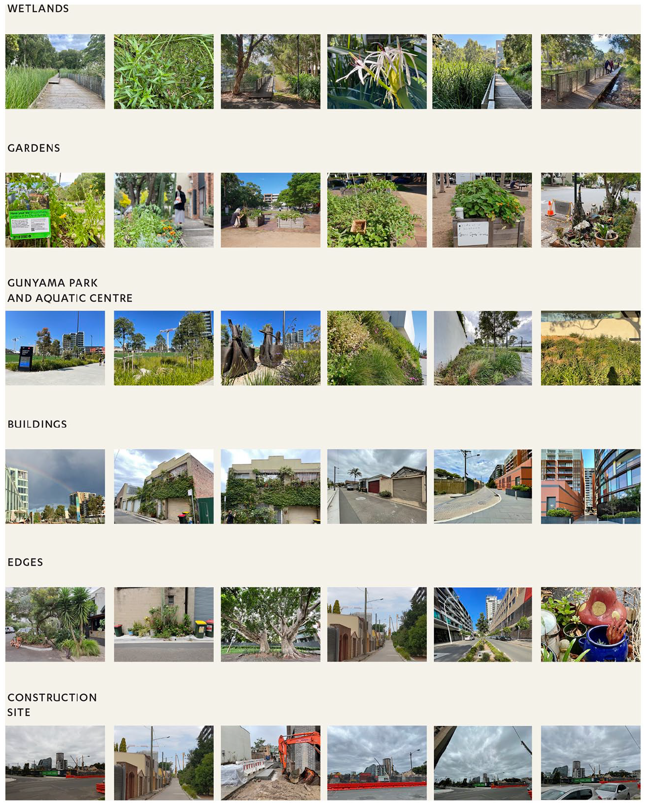
A sample of the thousands of photographs to frame and record the changes in the urban landscape at Green Square. © Mapping Edges
Gunyama Park and Aquatic Centre, city-led regeneration and landscape memory. © The authors
Princess Avenue, cultivation of plants and community. © The authors
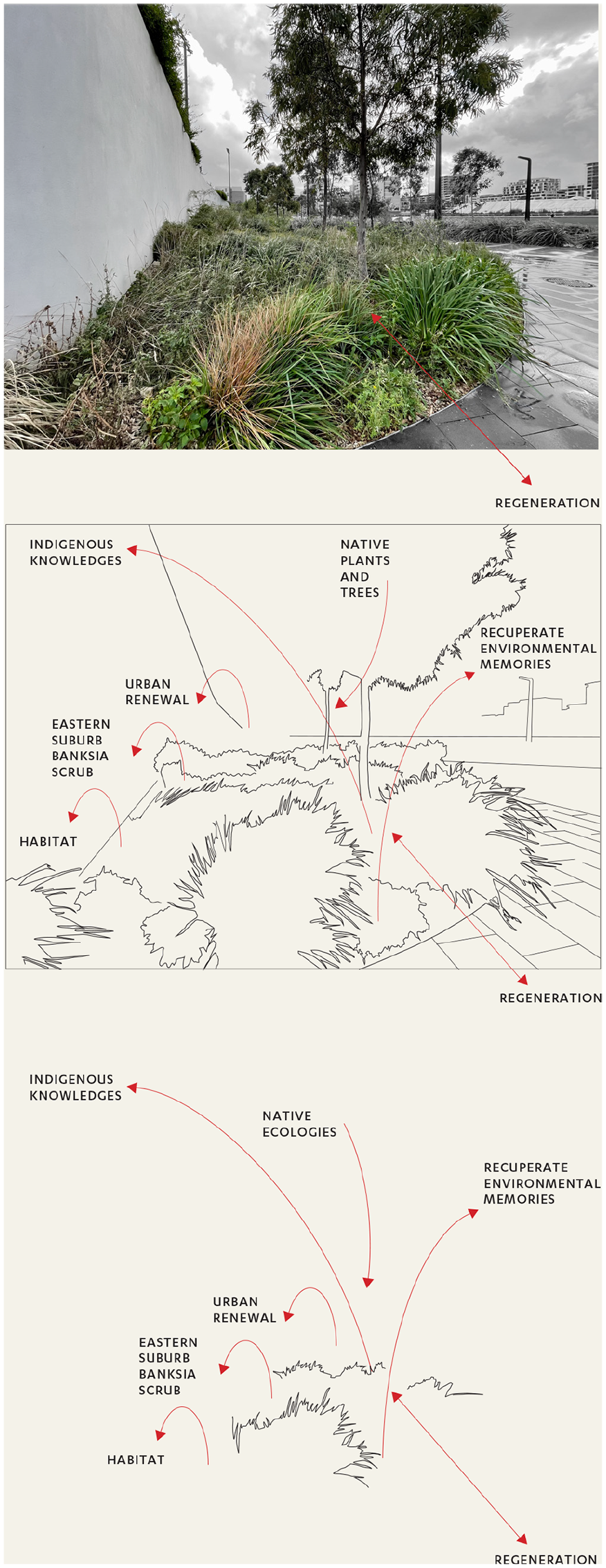
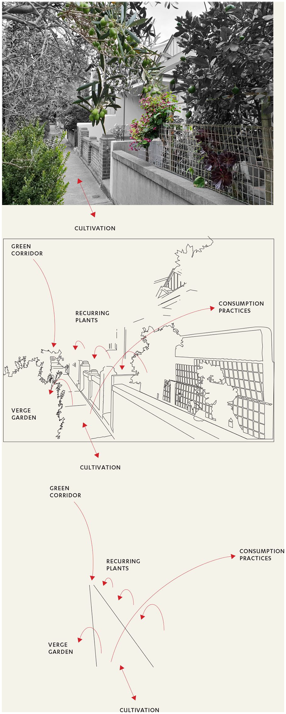
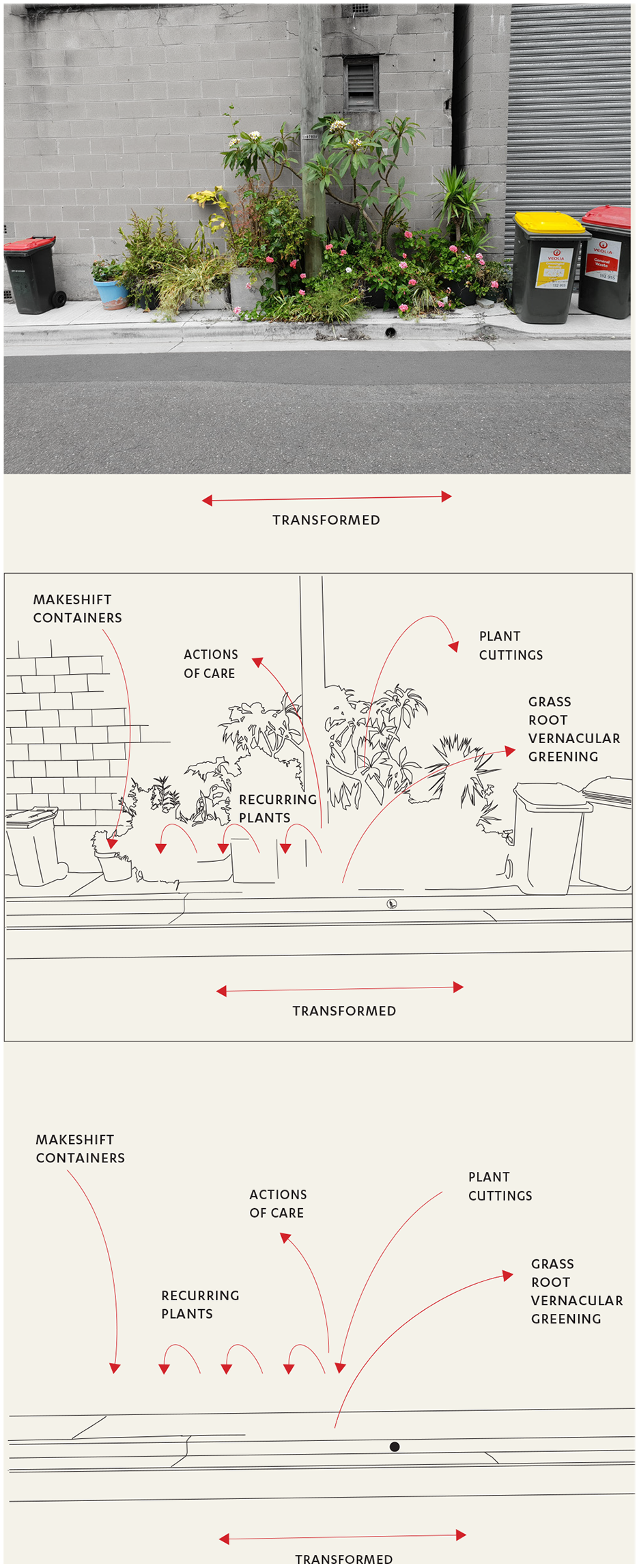
We photographed the same scenes over time to capture changes associated with demographics, development and the changes brought about by plants, animals and climate. From this archive, we chose four photographs. While all four photos show how nature has been mobilized, scripted, imagined and transformed to support urbanization (Swyngedouw, 2015: 609–610), we selected images that offer examples of different practices. Two images spotlight grass-root civic ecologies. One photograph shows a city-led urban ecology regeneration site and one shows the landscaped verges built as part of the urban renewal process.
These images highlight salient elements of civic ecologies (as explained in the second section of the article). For instance (see Figures 3 and 4), individual residents can begin the process of transformation of entire streetscapes and create vernacular landscapes (Jackson, 1984) that counter the designed homogeneity of new developments (Figure 5). On the other hand, new buildings can generate a sense of visual continuity, which is interrupted over time by the intervention of birds or wind scattering seeds of plants not intended for new apartment blocks’ garden beds (Figure 5). But we also use photo documentation to capture non-representational aspects of the environment, not as evidence of change, but to show the influence of non-human agents (Rose, 2022). In this case, we draw on photographic conventions and diagrams to illuminate the central role of civic ecologies in animating urban spaces.
Salisbury Lane: transformation and disruptive change. © The authors
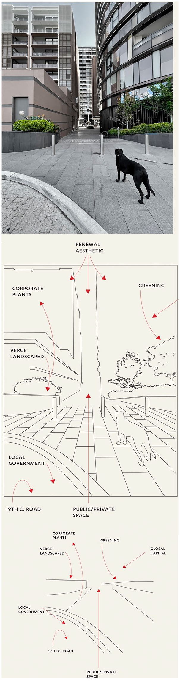
Portman Street: urban renewal landscape. © The authors
Photo Diagrams
We use diagrams to expand our photographs as a place-based visual methodology. With this, we mean producing visual forms of knowledge (Drucker, 2014) in relation to place (Toland and Christ, 2020). Photo diagrams can foreground and background trajectories in the urban environment that reveal or obscure civic ecologies. This technique recuperates environmental stewardship initiatives, practices and narratives that are absented or forgotten in the prevailing perception of urban renewal. Like other forms of image manipulation and augmentation to ‘extract meanings and knowledge lost in the photograph alone’ (Walby and Davis, 2022), diagramming is presented as a means to visualize emplaced processes.
We intend visualization in a broad sense. As discussed above, we refer to recent literature that argues for an understanding of photographs as interconnected with other senses and enmeshed in movement through space (Pink, 2011: 4). But we also lean on non-representational theory to create photo diagrams that aim:
To enliven rather than report, to render rather than represent, to resonate rather than validate, to rupture and reimagine rather than to faithfully describe, to generate possibilities of encounter rather than construct representative ideal types. (Vannini, 2015: 15)
As Vannini writes, the main point of difference of non-representational methodologies is not a matter of methods or strategies but a different orientation to the temporality of knowledge. The emphasis is on how knowledge will unfold in the future and have an impact on the reader or viewer, not on the accurate representation of empirical reality (p. 12). In thinking about ways to make patches of civic ecologies in the middle of urban renewal legible, we too wonder how to create visualizations that can reverberate with people, inspire action, animate place and generate new stories (p. 12). Photo diagrams are one of these ways.
These photo diagrams are designed as a triptych, and we propose they work as a three-step process to illuminate the civic ecologies collected during the photo documentation:
Desaturation and saturation of different parts of each photograph are utilized to reveal the civic, grass-root, or community-led environmental practices in the urban renewal precinct of Green Square.
Tracing of each photograph (as a drawing device) is used to emphasize the networks and relations in civic ecologies that are not static and to draw the eye to particular ecological elements. Thin lines, arrows and small annotations are used as structural devices, overlaid to indicate how civic ecologies exceed the vanishing points of the photo frame.
A further abstraction of the diagram omits the illustrative elements. It leaves only a few perspective lines reflective of the edges within each landscape in combination with diagrammatic elements – arrows, lines, and text. The text here ‘provides semantic value in the very scaffolding of its graphical structure’ (Drucker, 2013: 86) and highlights how these ecologies grow beyond the frameworks of their built environments. Lines and directions here capture the continuing socio-ecological process of civic ecologies to convey ‘not where life lies but rather to where it is going next’ (Vannini, 2015: 15). It is in this third step that the future trajectories of civic ecologies can be imagined, a process that could be useful to planners, urban designers and others involved in designing the city from the top down.
The graphic elements used in these four sets of diagrams are structural tools and comprise visual communication techniques such as a hierarchy of information, juxtaposition of image and text, and directional and navigational devices. Devices include lines, arrows, text and sketches as tracings (Burdick et al., 2012: 13; Drucker, 2013). ‘The elements of a diagrammatic system create value in relation to each other, not as an image of or stand-in for something else’ (Drucker, 2013: 84). These tools are not only analytical elements. They are also utilized as a form of multimodal communication ‘these graphical expressions are themselves meaningful as forms – they are a kind of poetics, or poesies, a bringing into being of meaning through making’ (Drucker, 2013: 88).
We present diagramming as a means to visualize emplaced processes, and make visible and legible civic ecologies and, by extension, other urban socio-ecological dimensions. Our diagrams build on earlier precedents of place-based visual methodologies, such as those of architects Alison and Peter Smithson, who also used photography to locate their drawings. In a 1989 interview, Peter Smithson reflects on the combination of drawings and photographs made often during their career. ‘He thought that it might be possible to invent a kind of graphics, together with documentation, of some sort you cannot imagine, that would guide the development of an area without prefixing forms’ (Baykan Günay, 1989: 71).
The following section surveys the four diagrams. We include stories, rather than captions, highlighting the doings and relations of civic ecologies in Green Square.
The Eastern Suburb Banksia Scrub (ESBS) is a critically endangered plant community that grew in the Sydney basin bioregion before colonization. ESBS occupied around 5,300 hectares of land on Sydney’s eastern suburbs coast. Today there are approximately 146 surviving hectares (Office of Environment and Heritage, NSW Environment, Energy and Science, 2018). Now replanted in Green Square, ESBS is more than an example of bush regeneration. This ESBS habitat results from multiple factors merging on the edges of a new municipal aquatic and sports centre. These factors include recommendations from the Aboriginal Community Development Office of the City of Sydney; the plants from the Aboriginal Social Enterprise IndigiGrow, which sustains culture, Country and community through a nursery specialized in native plants; policies and guidelines (Hromek et al., 2020); landscape architecture and planning. The civic ecologies at this edge then enact Country and Indigenous knowledges and recuperate environmental memories (ESBS seeds can regenerate if the soil is free from leaf litter and weeds), as well as contributing to the crucial regeneration of native ecologies. Shannon Foster, a D’harawal eora Knowledge Keeper, writes that today the presence of plants emerging in urban development areas represents ‘the un-forgetting of knowledges and stories that have been silenced and, sometimes, erased from our lives’ (Foster, 2022).
Princess Avenue unfolds in one long verge garden. It all started with one gardener, who bought and converted a warehouse in the early 1990s and set out to green the ‘dustbowl’ that was his street (Crosby and Vanni, 2022). Researchers have studied verge gardening as a public pedagogy that provides ‘opportunities for encountering and learning about food cultivation and consumption practices at the mundane level of the footpath’ (Hsu, 2019: 821), as spaces of social learning (Lopes and Shumack, 2012) and sites that can boost biodiversity and ecosystems but are also shaped by cultural norms and beliefs (Marshall et al., 2020). Verges are examples of civic ecologies because they bring together care for the neighbourhood and the environment simultaneously, enrich biodiversity, provide green corridors for wildlife, connect people and create learning opportunities. Cuttings and horticultural knowledge are exchanged together.
In Princess Avenue, the original verge inspired neighbours. Some plants recur along the street, demonstrating the residents’ exchange of cuttings and seeds. Recent urban gardeners have bought and converted terraces and warehouses in the last decade, growing ornamental plants for aesthetic value or raised beds with edible herbs. Long term residents of terraces, who arrived as migrants from Greece in the 1970s to work in the nearby factories, cultivate olive trees, herbs and citruses. These practices also influenced local government policies that now encourage people to garden on the verge.
Local governments’ approach to verges also changed in the late 2010s. City streets, once lined with council-maintained grass strips, now harbour a greater variety of plant life (often water sensitive) cared for by residents. This transformation required a shift in governance. In 2020, the City of Sydney issued a policy to support residents ‘taking the patch of the city out the front of your house or business and making it beautiful’ (City of Sydney, 2020).
Early 20th-century land subdivision maps show Salisbury Lane as an alley providing access to the rear entrances of buildings on two residential streets, Princess Avenue and Paul’s Road. Today, Salisbury Lane is a site in transformation. The side of the laneway shown in the photo still provides access to garages and back entrances of buildings on Princess Avenue. The original buildings on Paul’s Road have been demolished, and double back-to-back terraces have been built on the original footprint so that Salisbury Lane is a back entrance on one side and a front entrance on the other. In other words, an example of restructured versus redeveloped urban space. While this is the most obvious transformation, the alley has also changed due to actions of care by residents, who have created a landscape of container plants in response to the disruptive change in their back alley. Following the same dynamic seen on Princess Avenue, some rambling plants are recurring along the laneway, giving it a distinctively vernacular character that escapes the more manicured and homogeneous examples of urban renewal plantings on the opposite side of the lane. Containers on this side are often repurposed: vases alternate with recycled boxes, drums, and even a wheelbarrow, planted with flowers and anything that grows from cuttings. This gathering of assorted plants and recycled objects used as containers creates a visual interference in the renewed landscape of the area, opening the possibility to recognize civic ecologies in the urban space.
Although evocative of ecological richness, the name Green Square was chosen in honour of Mr Frederick Green, a former local alderman and lord mayor (City of Sydney, 2012; Parliament of New South Wales, 2022). Initially, a few hundred metres from where this photo was taken, a tiny grassy patch was named after him: the original Green Square. This area was earmarked as a significant urban consolidation site in the 1995 metropolitan strategy (Searle, 2007). In 2021, the estimated resident population for Green Square was 34,253, with a population density of 12,049 persons per square km (id Informed Decisions, 2022). The City of Sydney’s greening policy identified laneways as community owned land that could be transformed into green areas (City of Sydney, 2021: 42). The same policy also highlights the benefits of rooftops, green walls and medium level plants in residential buildings. Advantages include heat reduction, shade and an enhancement of aesthetic and property values. Developers and architects interpret this policy in different ways in the ‘slippery’ spaces between private and public land. Some create native plants gardens. But the majority provide planters on the edge of streets and laneways filled with a limited range of low-maintenance hardy perennials, including birds of paradise (Strelitzia) and Xanadu (Thaumatophyllum xanadu). The uniformity and repetition of this urban renewal landscape leads to the invisibility of plants as connected elements of civic ecologies: plants become just design elements, like bollards, railings, or bicycle stands. In addition, gardens designed and maintained by developers do not invite residents’ care and engagement nor encourage biodiversity and habitat for birds, reptiles or insects.
Conclusion
This article offers a visual communication experiment that addresses forms of urban environmental illegibility and could enhance visual literacy of people in urban ecologies. We hope this work contributes a new perspective on ways to understand urban renewal as a socio-ecological process.
To sum up, we experimented with photographic diagramming to address the problem of the illegibility of civic ecologies in the urban environment. The process of photo diagrams can contribute to our understanding of Australian cities as Country and as ecologically rich sites. Our research is in Green Square because this area provides an example of a place in which meaning (and buildings) are under construction. In one sense, this place is manufactured from the top down. In other ways, important voices diverge from Green Square’s dominant narrative and greening practices.
Both in the specific context of the Green Square and more generally, photo diagrams can represent civic ecologies. Perhaps more importantly, they might actually be able to form and consolidate significant aspects of civic ecological processes themselves, such as collaboration between neighbours and connection to natural systems. As they make obfuscated relations in the city more visible, photo diagrams can also be used for critique, for instance to point out careless, short-term thinking in urban renewal projects.
Photo diagrams open scenes of civic ecologies to broader and more profound interpretation.
This is a critical aspect of working with civic ecologies in a place-based way to ensure the concept is not imported from one context to another without care and sensitivity. Photo diagrams also contribute to the field of visual communication design by offering a way to make present, rather than represent, ecological elements in the landscape that yet exceed the frame of the photograph.
Footnotes
Acknowledgements
These civic ecologies are on Aboriginal land, on the sand dune and wetland Country between Gamay (Botany Bay) and War’ran (Sydney Cove). We acknowledge the traditional custodians of Green Square and we honour Aboriginal peoples’ custodianship in this Country. We pay our respects to Elders and Knowledge Keepers past and present, and we extend our respect to all the Aboriginal peoples who have cared and continue to care for this Country.
Data Availability Statement
Data sharing is not applicable to this article as no datasets were generated or analysed during the current study.
Biographical Notes
SARAH JANE JONES, University of Technology Sydney, is a Lecturer in Visual Communication. She examines ways to incorporate storytelling into urban wayfinding design – central to this is exploring the relationship between physical signage and digital wayfinding.
ALEXANDRA CROSBY, University of Technology Sydney, researches more-than-human design, recombinant ecologies and emergent forms of design activism. She works together with Ilaria Vanni as Mapping Edges Research Studio. Her research is on more-than-human design, recombinant ecologies and emergent forms of design activism.
ILARIA VANNI, University of Technology Sydney, is a transdisciplinary researcher across social sciences and design as transformative fields of research and practice. Her current work studies and amplifies urban ecologies at a time when the impact of climate change on our cities calls for a better understanding of the relations between people, nature, culture, and urban space. She works with Alexandra Crosby as Mapping Edges Research Studio.