
Abstract
This practitioner piece considers cartographies that permeate and enable the practice of film production. Using his feature film PUNCH (2022) as a case study, Welby Ings discusses ways in which mud maps, overhead maps and relational maps were used as communicative devices in establishing a shared template for understanding the positioning of fictional spaces. Mud maps (see Danesh’s ‘7 pro tips for managing crew parking when filming on location’, 2019), are conventionally used in film production to describe geographies and inform cast and crew about locations. Overhead maps (see Isham’s ‘Creating overhead maps for film directors’, 2017), were employed in association with shot lists, as ‘graphic prompts’ when directing complex scenes. Relational or ‘mental maps’ (see Bays’, ‘Between the scenes: Choosing locations’, 2015) were used in conjunction with site drawings, to establish spatial blueprints for discussing the internal logic of the film’s world with the director of photography, production designers, location scouts, sound recordists, costumers and postproduction collaborators. As the film’s director and cartographer, the author created these maps with a unique visual language that included distinctive considerations of marginalia, typography, line weight, texture, historical allusion and colour, to communicate the emotional tone of the film’s world.
Introduction
In November 2022, a feature film PUNCH that I wrote and directed was released. Premiering in competition at Tallinn Black Nights, the movie was selected for numerous international film festivals. PUNCH tells the story of a young gay boxer who lives with his alcoholic father in a small, coastal New Zealand town. It critiques the veneer of acceptance that often accompanies narratives of diversity and inclusion, while tracing the relationship between two very different gay men; a ‘straight passing’ adolescent and a takatāpui (indigenous, Māori gay youth) who confronts the town’s conventions of gender expression. (The film’s trailer can be accessed at: https://www.youtube.com/watch?v=KYtR-j88fV8).
While such movies are often discussed in terms of structure, this article considers the creation of the film’s locational spaces. Using maps that I designed during the production of the movie, I discuss fictional cartography as a form of visual communication (Figure 1). As a director, I find that the maps I make function as a helpful form of ‘visual shorthand’ that enables me to think through the ethos of a scene or illustrate technical considerations when discussing continuity with crew and producers.
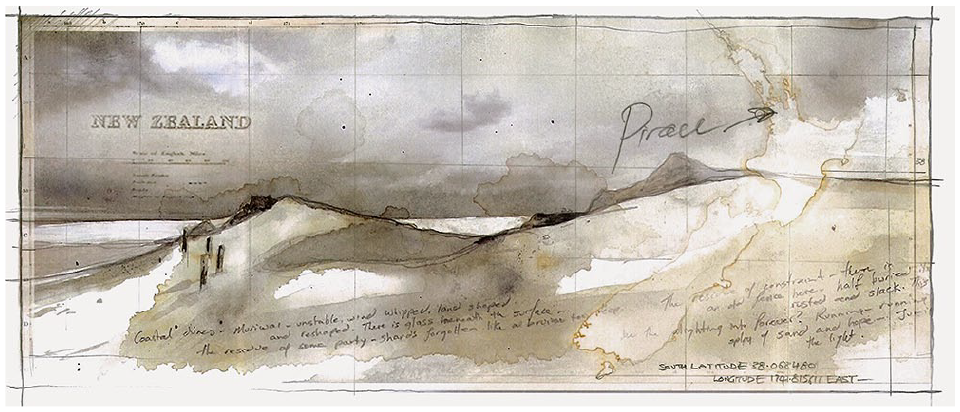
PUNCH is set in the small fictional town of Pirau on the west coast of Te Ika-a-Māui (the North Island of New Zealand). The geography of the region is marked by black beaches, ravaged trees, infestations of stinging jellyfish, huge sand dunes and the decaying vestiges of people’s attempts to impose their will on a resistant landscape. Since, during production, we had to assemble this world in disparate parts of the country, illustrated maps like this provided emotional and geographical reference points for production designers, directors of photography and location scouts, as we sought to construct continuity in the work.
Cartography and Film
Relationships between cartography and film have given rise to diverse theoretical discourses that consider issues as distinct as cinematic structure, meaning making and content. Although Giuliana Bruno (2002: 71) has claimed that film might be understood as ‘modern cartography’, the idea that a film can function as, or in fact can be, a map can be traced back to Walter Benjamin’s (1999[1927–1939]) considerations of a chronological, cinematographic cartography of Paris. Roberts and Cohen (2015: 68) have proposed the term ‘cinematic cartography’ to describe ‘the locational properties of the moving image, and the concomitant processes of spatial and temporal navigation – historiographical, ontological, geographical, archaeological, architectural – that these make possible’. Their focus on relationships between cartography and film contributes to a growing body of theoretical discourse (Aitken and Craine, 2006; Bruno, 1997, 2002; Caquard and Fraser Taylor, 2009; Caquard et al., 2008; Castro, 2006; Conley, 2006; Roberts and Cohen, 2015; Taien, 2015; Thrower, 1959).
However, although since the late 1990s the nature of film has been discussed in relation to cartography, maps have permeated cinematic narratives for decades. Featuring in early work like Huston’s The Treasure of the Sierra Madre (1948), maps have made distinctive appearances in Gilliam’s Time Bandits (1981), Spielberg’s Indiana Jones and the Raiders of the Lost Ark (1981), Cuarón’s Harry Potter and the Prisoner of Azkaban (2004), Anderson’s Moonrise Kingdom (2012) and Schreier’s Paper Towns (2015).
With the evolution of digitized map making, in the last 20 years, cartography has also influenced the design of a diverse array of film and television title sequences. Significant among these are Yount’s end credits for Oblivion (2013), Imaginary Forces’ design for Manhattan (2014), Kim’s graphics for The Man in the High Castle (2015), Becker’s sequence for Underwater (2020), and Wall’s animated, three-dimensional map for Game of Thrones (2011–2019). Of these sequences, it is perhaps Wall’s animated cartography that forms the most sophisticated, relational blueprint for the geography of a complex fictional world. Here, different locations feature in each episode, indicating both the geographies that will be traversed, as well as the political expanse of the wider narrative.
However, although one can theoretically read film as a form of map and trace the appearance of maps as content inside movies, cartographical practices also operate inside film production itself. These maps do not appear on the screen and they are rarely referred to in theoretical analyses. This may be because they operate beneath the surface of a cinematic narrative, as production or directorial tools.
In considering the film PUNCH, three cartographical forms warrant discussion: mud maps, overhead maps and relational mapping.
Mud Maps
There is a truism that the culture of film making is a cross between the circus and the army. This is because, when filming on location, one has to wrangle complex levels of scheduled movement while simultaneously maximizing the potentials for creative endeavour. Because producers are often working with large numbers of people, when cast and crew arrive at a new site they need to navigate the location effectively. To enable this, they are often furnished with a mud map. A mud map is normally attached to a Call Sheet (daily filming schedule) and it provides people with an illustration of a new location’s surrounding streets, distinguishing landmarks, base position, ‘equipment, infrastructure, camera position/s, pedestrian and or traffic control, generators, and amenities’ (Fleming: 2020, para 3). Mud maps derive their name from an old Australian bush term that described a rough, geographical outline drawn in the dirt by outback travellers. Sometimes also called site plans, these maps are often sketched and annotated with notes and directions (Figure 2). Danesh (2019) argues that such maps are necessary because they help cast and crew to navigate unfamiliar spaces, reduce parking delays, ensure that vehicles comply with insurance policies, indicate points from which shuttle buses will alight and depart and, as a broader consideration, minimize the potential for complaints from local residents.
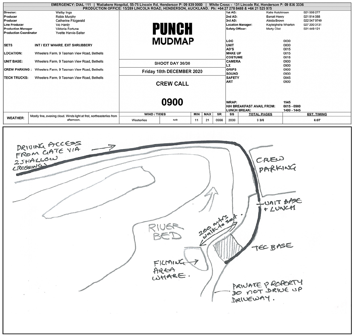
This mud map was designed for cast and crew on day 30 of a 6-week shoot. Technical data at the top of the page listed weather details, parking areas, access and distances between the sets and the main unit. The accompanying sketch illustrated geographical relationships including river width and direction and basic topography. The drawing was accompanied by handwritten notes relating to private property and a warning of necessary stream crossings when driving across country to the location.
Overhead Maps
An overhead map is normally a hand-drawn device used by directors to sketch out details and progressions in a complex scene. As a graphic, it provides a quick reference for the proposed positioning of camera setups, actor blocking (positioning) and the location of props (Figure 3). Normally interfacing with a shot list, overhead maps can also function as a discussion document with crew (Isham, 2017). The iconography of such maps is often cursory and subjective. (For example, I use a circle and V to specify the direction of a camera shot and very rough linework to indicate props and the perimeters of the set.) Such notations operate as a quick memory prompt because on set, as a director, you are working under considerable pressure and an overhead map enables you, at a glance, to relocate your bearings as the scene progresses.
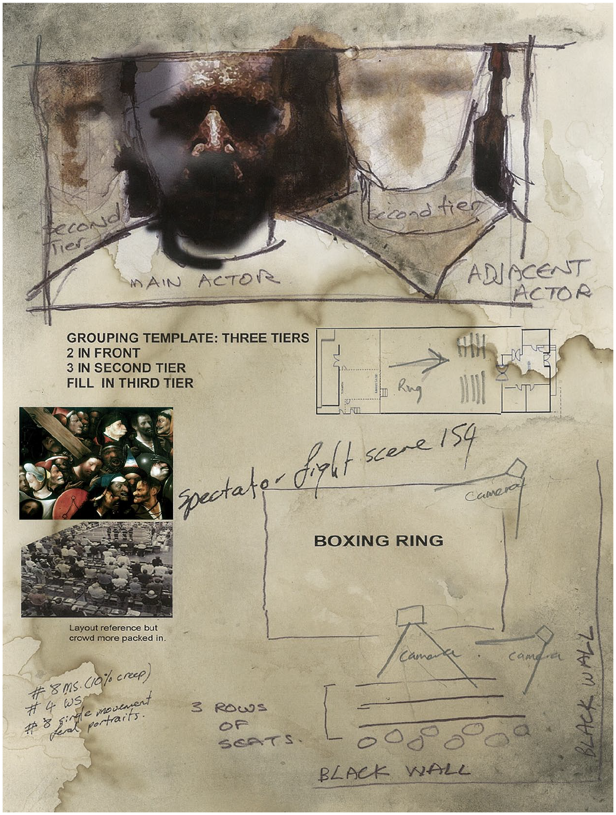
This overhead map was used while shooting a sparse crowd scene at a small-town boxing match. Individual and dual portraits were required as a series of feral vignettes that could later be edited into wider group compositions and action shots of fighting inside the ring. The map shows the proposed system of tiering actors. In addition to visual references, it also contains proposed camera set-ups and an indicative shot list.
Relational Maps
Although mud maps and overhead maps are cursory forms used by producers and directors for specific times and locations, relational or ‘mental maps’ (Bays, 2015) operate as a more comprehensive and expansive form of visual communication.
Relational maps are generated prior to filming and they can be used through all phases of a production to establish the internal coherence of a fictional space. Directors of photography, production designers, location scouts, sound recordists and re-recording mixers use these maps as a spatial blueprint that indicates where events and geographical or sonic features exist in relation to each other. Thus, relational maps become reference points when considering light, directional movement, location backgrounds, atmospheric sound and credibility issues relating to time and distance.
Relational maps assist with the construction of a coherent, comprehensible geography for a film. Because they establish the relational logic of space, they strengthen meaning, so when an audience watches the story, locations and environs (often initially signalled with establishing shots) are memorized and easily understood. This is important because significant sites may be revisited multiple times in the story and one wants the audience to be absorbed in its emotional and narrative flow, without being distracted by questions about where a scene fits into the wider world of the narrative.
Roth (2021) observes that maps (like stories) are partial abstractions that enable us to understand worlds because they reduce and nominate specific information. To ensure high levels of comprehensibility, before shooting PUNCH, I designed a number of relational maps that were supported by indicative location sketches (Figures 4 to 8).
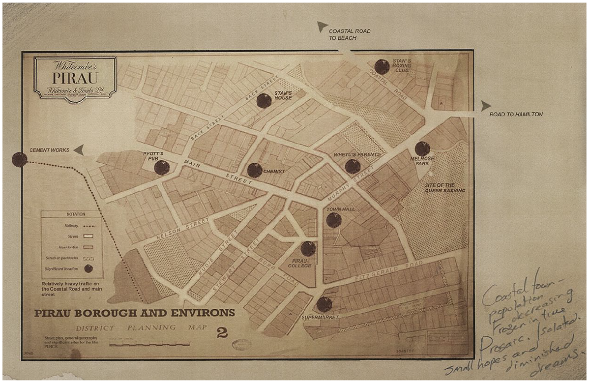
This street map of Pirau provided a coherent template for sound designers, who needed to consider the route that we hear a rubbish truck taking in the morning, the pervasive quality of background music emanating from the local pub and the direction from which we might hear dogs barking at night. Location scouts used the map to ascertain the buildings students would pass on their way home from school, where the wealthy streets separated from poorer housing, the distance of the cement factory from the town, and the remote and therefore unsafe nature of a local park that would become both a playground and the site of a violent, unwitnessed assault.
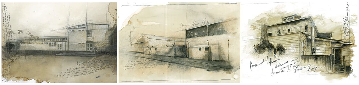
A sample of location sketches. Drawings like these speak to the tone of the architecture that I envisaged as populating areas on the map. Like the cartography, these drawings had a dialect; the brooding unease of the prosaic . . . a sense that just beneath the veneer of the ordinary, lay alienation and neglect.
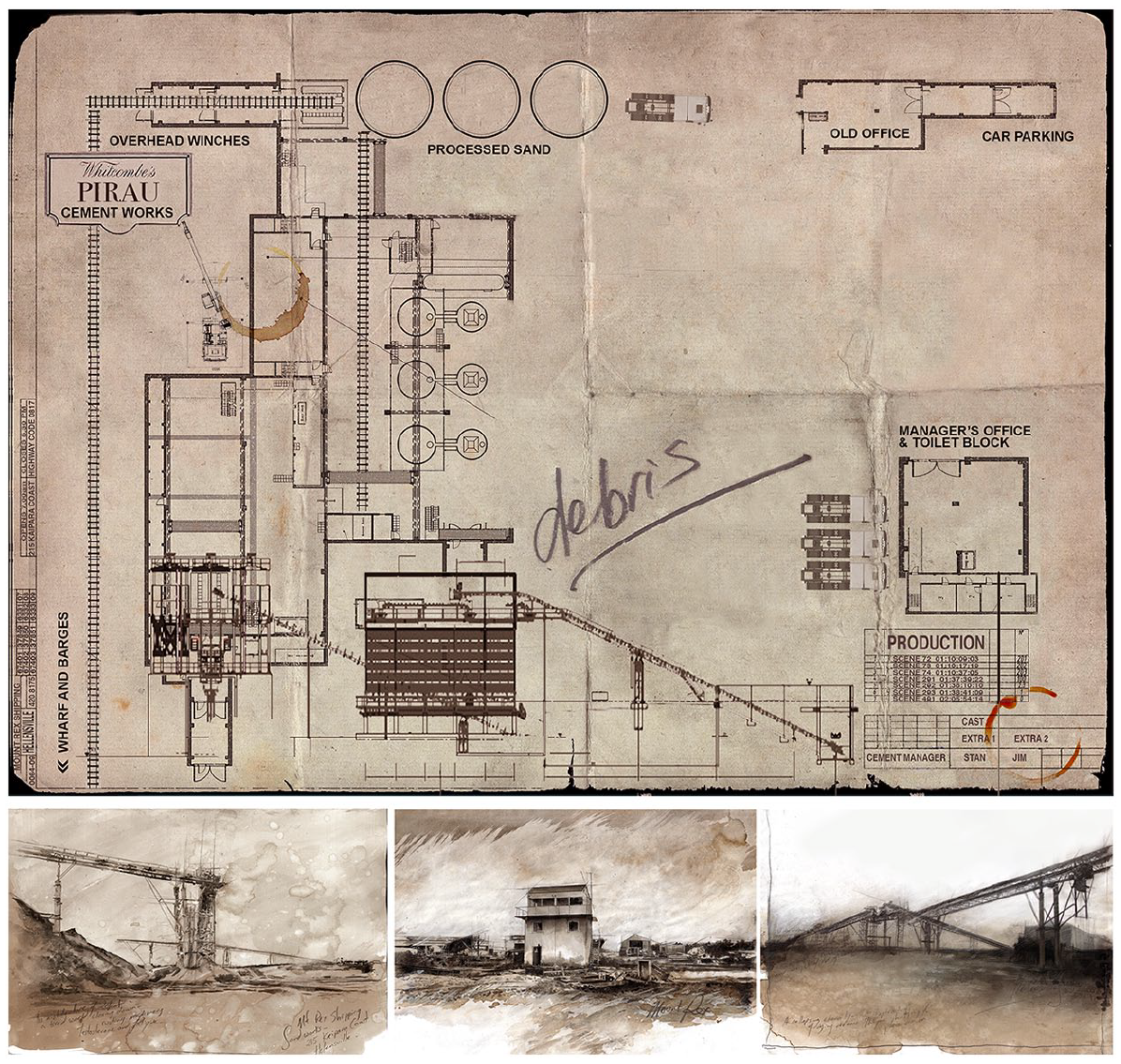
Although relational maps were useful as spatial templates for positioning scenes and actors’ movements, the process of constructing both the maps and location sketches also enabled a period of creative embodiment because, while drawing, I was able to graphically dwell inside the tone of the location and the story. In the film, the cement factory is in its last days of existence; its walls are peeling, its machinery is falling apart, its management is in ruins and its environs are littered with debris. Everything in this world is corroded by industrial decay. It is from this factory that Jim’s father is eventually fired and it is here that the boy wanders desolate, after he betrays and humiliates his friend.
Maps like this were important to sound designers because sonically the coastal spaces were deeply relational and always in transition. During post-production they used this map to position things like the weight of waves heard through a bank of trees. They were also able to locate geological substrates that changed the tone of running water and demarcations that separated the call of seabirds from those of the land.
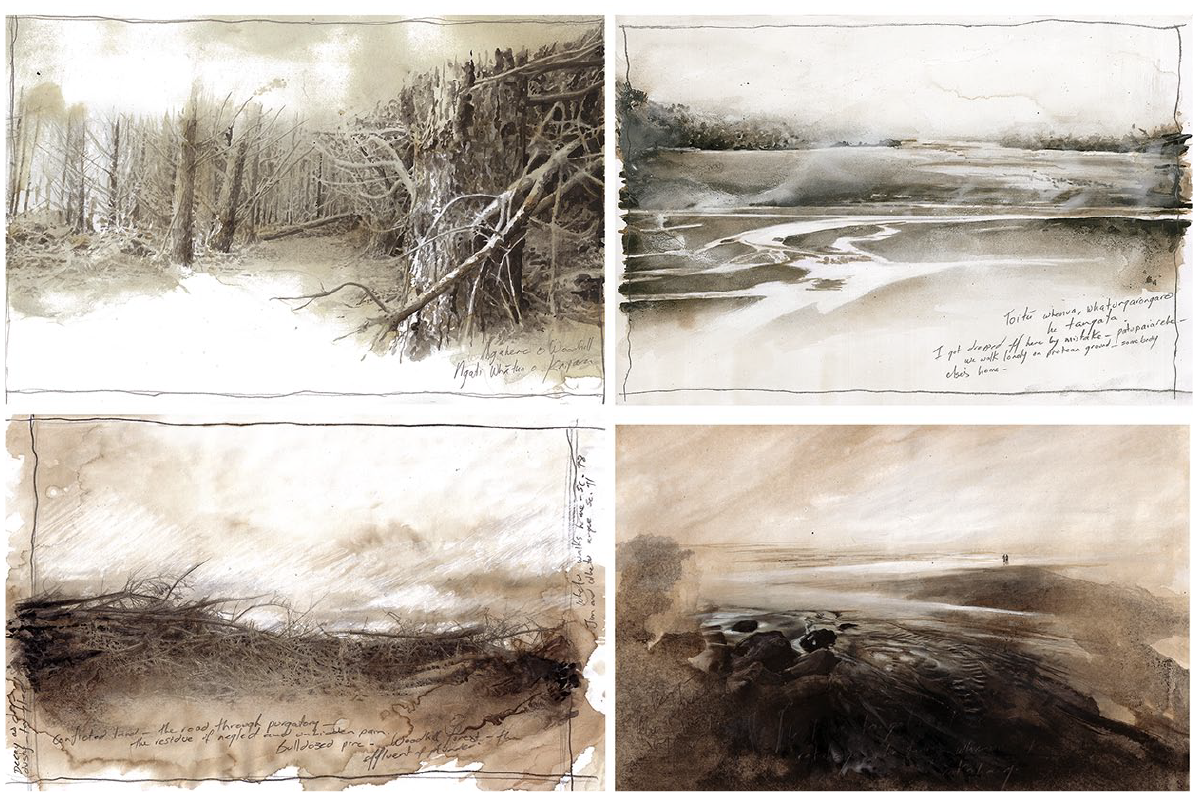
Examples of coastal sketches that emphasized feathered lightness set against weight and decay. These rapidly rendered drawings were sometimes notated with references to story lines or observations about the environment. They were sketched onto whatever paper was available, using graphite pencils, washes made of coffee granules, old acrylic housepaint and Indian ink. This is because the drawings were often snatched opportunistically from landscapes I passed in my truck or stumbled upon while tramping.
These maps reach beyond the objectivity often assumed in cartography (Elwood and Leszczynski, 2018; Rose, 1997) because they employ distinctive visual dialects. In PUNCH they, and accompanying drawings, described a small, timeless, conservative town. Here contemporary characters lived in the houses of their grandparents, they frequented parks with equipment that had corroded over generations, they drank in pubs, worked in factories and attended churches that had remained stolid and unchanging. The world of Pirau was decaying but resolute.
Graphically, relational maps like these employ legends, arrows, marginalia and titles to construct emotional tone (Caquard and Cartwright, 2014; Roth, 2021). However, I also used distinctive typography, line weight, texture, historical allusion and colour to enhance the memorability of information (Bateman et al., 2010; Borkin et al., 2013) and underscore the timelessness and emotional weight of the film’s world. To illustrate these features, we might consider three physical spaces within the film: the town of Pirau, the cement factory and the coastal environs.
The Town
The maps of Pirau, while establishing physical relationships, spoke to emotional resonance and the social structure of the community. In the town, the boxing club was nestled in a back street. Conversely, the pub and memorial hall formed part of the socially elevated, historical infrastructure of settlement. These buildings were located at either end of the main street and, along with the college, they separated the more densely populated but affluent real estate on the southern side of the community from the poorer, northern part of town.
The Cement Factory
In the film, the cement factory was a metaphor for the decay of hope. I created it by drawing a series of site maps. These functioned as a fictional ‘overlay’ onto an existing, commercially active sand works. Because spatially the original location lacked the level of decay that the film required, drawing fictional site maps enabled me to synthesize areas of the location into a reconceived world. These drawings then enabled me to work with production designers as they created constructions for masking unwanted features. I also used the maps in discussions with the director of photography, as we discussed potential camera angles that would enable us to avoid unwanted details.
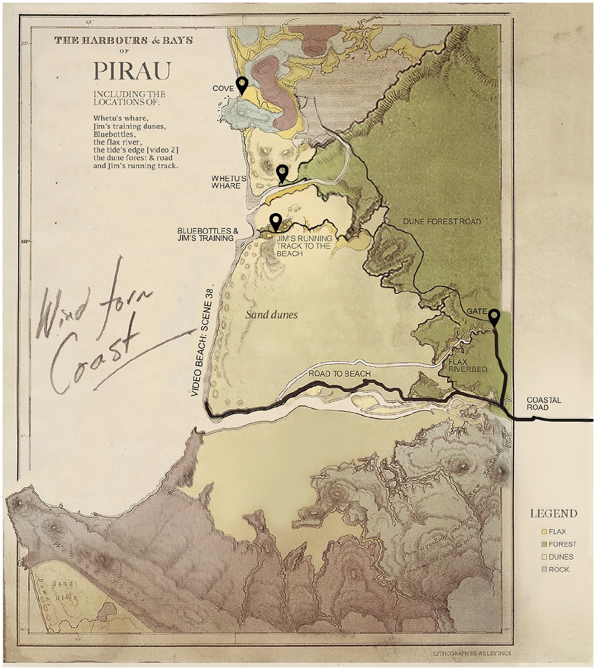
The Coast
Pirau is positioned slightly inland from the ocean. However, its coastline is where the film’s other main character (Whetu) lives. This is a beautiful, forcefully shaped world. Here, the land is rugged, and its riverbeds, coastlines and sand dunes carry signs of failed attempts at farming and forestry. Maps of the coastline took many weeks to construct. They were underpinned by months of relational thinking that guided both the screenplay and the director’s notes. Because of the timeless nature of the film’s world, I produced the final iterations of these maps as faded, distressed prints, reminiscent of something that might have been pulled off a forgotten wall.
Conclusion
Maps are abstractions of existing or imaginary worlds, but they can also be ways of talking about tone and emotion. Larsen (2010: 151) observes that a map ‘does not just chart, it unlocks and formulates meaning; it forms bridges between here and there, between disparate ideas that we did not know were previously connected.’ Understanding how maps are used to visually communicate disparate ideas inside story production may contribute to a broader understanding of film as a phenomenon.
In the production of PUNCH, three distinct forms of map were employed. Mud maps were designed to describe geographies and inform cast and crew about locations. Such maps are common and function as an organizational tool in film production. Overhead maps are less ubiquitous and only some directors use them. In association with shot lists, I employed them as a graphic prompt when I was directing complex scenes. These maps rarely survived a shoot because I carried them around with me, often scribbling over them and discarding them once their immediate purpose had been served. Conversely, relational maps were more permanent in nature. These functioned as spatial blueprints that I used in discussions with other collaborators as we built the internal logic of the film’s world.
As pdfs and printouts, these maps appeared on laptops, pinned to walls and in the folders of location scouts, production designers, costumers, directors of photography and post-production artists. They accompanied the film as it made a journey through pre-production, across production and, finally, into the post-production studios.
Goldin and Muggah (2020: 8) attribute to Einstein the statement, ‘You can’t use an old map to explore a new world.’ Indeed each new film world has its own cartography, be it visible or invisible. In PUNCH, fictional maps functioned as visual communication devices that enabled teams creating the work to consider coherent relationships and plan strategically . . . but the project’s cartography was more than this. The maps in the project had a distinctive voice, a dialect that spoke from inside the ethos of the story. This voice talked to the nature of a world that was in the process of gathering form. In this regard the maps formed a distinctive bridge between the imagined and the realized.
Footnotes
Declaration of conflicting interests
The author declared no potential conflicts of interest with respect to the research, authorship and publication of this article.
Funding
The author received no financial support for the research, authorship and publication of this article.
Biographical Note
WELBY INGS is a Professor in Design at Auckland University of Technology. He is an elected fellow of the British Royal Society of Arts and a consultant to many international organizations on issues of creativity and learning. He is an award-winning filmmaker, author, designer and playwright whose films have qualified for the Oscars and won numerous international awards. Although he holds a PhD in narratology, he publishes widely on practice-oriented inquiry, pedagogy and film design. In 2001, he was awarded the Prime Minister’s inaugural Supreme Award for Tertiary Teaching Excellence, and in 2013 and 2022, respectively, medals for his contributions to research and education.