
Abstract
Drone visuals are rapidly becoming part of our sociocultural imaginaries, generating distinct images that differ from traditional visual conventions and producing unexpected perspectives of the world that reveal hidden aspects of our surroundings. Despite the growing use of camera-laden drones in a range of commercial and non-commercial activities, to date, little scholarly attention has been paid to the semiotics of drone visuals. This article is the first to draw specific attention to the compositional structure of drone visuals, combining social semiotic analysis with ethnographic insights to assess how they are changing the way we think about the world. Exploring drone hobbyists’ and developers’ perspectives on drone usage and the visuals they generate, the authors identify and examine three frequently occurring characteristics of drone visuals: top-down views, 360-degree panoramic views and ‘classic’ landscape perspectives. The critical analysis of these peculiarities leads them to argue for the potential of these innovative visions to reshape our visual culture. In their conclusion, the authors aim to open a conversation about the way technological advancements mark important sociocultural changes in sense-making processes, geographical imaginations and everyday life experiences.
Introduction
Nowadays, visuals are widely used in telecommunication technologies and are ever present in many people’s daily lives. We are surrounded by different (audio)visual modes (e.g. photos, videos, televisions, animations) and channels of communication (e.g. TV, social media), all of which offer views of the world and translate them into rich semiotic structures. This proliferation has been accentuated by the increased use of smart technologies, embedded also in personal mobile devices, which has had a considerable impact on personal social interactions, as well as communication and information sharing. These modes and media show how our lives are becoming increasingly visual and how contemporary visual practices are characterized by complex interrelations between digital technologies, networked infrastructures and social practices (Serafinelli, 2018). Within this context of technological advancements, drones – understood as unoccupied aerial vehicles – are generating images that differ from traditional visual conventions, offering imaginaries that are not yet appropriated by our contemporary visual culture.
Drones, as flying robots, can take photographs from new unconventional perspectives, and this affordance has the capacity to change the way we see the world. Furthermore, through their autonomous movements and 360-degree lens, drones can access hard-to-reach or risky spaces, thereby providing a wealth of visual information which would otherwise be hard to obtain with ordinary cameras. In recent years, drones have moved beyond their military origins to be employed across a range of fields to capture visuals, from post-natural disaster evaluation (Ruiz Estrada and Ndoma, 2019) and citizen activism (Tuck, 2018) to wildlife conservation (Garrett and Anderson, 2018) and archaeological surveying (Campana, 2017). Drones have also started to attract the attention of cultural and creative industries, particularly tourism, journalism and filmmaking, for their capacity to dramatically decrease the cost of production and offer innovative visions (Santamarina-Campos and Segarro-Ona, 2018). The reduced cost of drone technology has also led to the emergence of a strong consumer drone market, with many hobbyists now using drones to take photographs and videos from the sky. It is this unique subset of drone users and visuals that forms the focus of the current study.
Despite the growing use of drones in a range of industries and recreational practices, scant attention has been paid to the specific characteristics and aesthetics of drone visuals. To address this shortcoming, this article offers a small-scale study of photographs produced by drone hobbyists with the purpose of laying the groundwork for further studies of drone visuals. Adopting a sociocultural perspective, it explores qualitatively: (i) the semiotic features, compositional structures and meaning potentials of drone visuals; and (ii) what users think about their innovative visual perspectives. The drone visuals are approached through a combination of social semiotic analysis (Kress and Van Leeuwen, 1996; Ledin and Machin, 2018, 2020) and ethnographic insights from interviews conducted with drone hobbyists and developers. By supporting visual observations with detailed information provided by individuals, this study identifies the motivations and connections between semiotic choices in drone visuals, their meaning-making practices and their sociocultural effects (Pink, 2007). In doing so, it demonstrates the importance of moving iteratively between drone visuals and the practices/contexts in which they are embedded to foster an in-depth understanding of the ways in which they are shaking up our visual imaginaries. The article concludes with a critical discussion of how drones and the incorporation of their visuals in many everyday activities are producing substantial changes to the way we experience the world and, in turn, shaping our visual culture in innovative ways.
Drone Views: Their Study and Applications
Over the past 10 years, there has been a marked growth in academic research on drones. This interest was initially sparked by the increased usage of armed drones in military operations, particularly by the US in its ‘War on Terror’ in Afghanistan and Pakistan (Chamayou, 2015). Consequently, much work has focused on their history and emergence (Kaplan, 2018; Richardson, 2020), as well as key issues related to their usage, including implications for warfare and surveillance (Boyle, 2015; Neve, 2015), the ethics of ‘killing from above’ (Byrne, 2018; Kirkpatrick, 2015) and the expansion of conflict spatialities, territory and sovereignty (Kindervater, 2017; Shaw, 2013).
Given the military drone’s association with unbalanced power relations, considerable research has been carried out on vision and visuality. Gregory (2011), for example, has looked at the ‘scopic regime’ of drone warfare, arguing that drones provide spaces of both constructed visibility and invisibility, while Maurer (2016) has developed this idea further in relation to violence as a form of manhunting through the scopic dimensions of hypervisibility, visual immersion and invisibility. Parks (2018) has also conducted important work on the vertical dynamics of drone warfare and how their ‘vertical mediation’ is altering life on earth by reorganizing where and how people move and their feelings about the sky. Studies have also considered how military drones are visualized across a range of media, including video games (Stahl, 2013), fiction (Smethurst and Craps, 2019), artwork (Monahan, 2018), films (Hankte, 2018) and news reports (Ohl, 2015).
Since the rapid expansion of drones beyond military contexts, many scholars have turned their attention to off-the-shelf consumer drones and their everyday usage by entrepreneurs, hobbyists, citizen scientists and artists alike (Jackman, 2021; Richardson, 2020). This democratization of the drone has advanced studies in drone vision and visuality, with research being conducted on how drones reshape our vertical publics through new modes of relational experience (McCosker, 2015a; Garrett and McCosker, 2017), how they create a ‘new camera consciousness’ (McCosker, 2015b; McCosker and Wilken, 2020) and how they diversify traditional meanings of verticality and undermine the singular notion of the panoptic gaze (Mangold and Goehring, 2019; Zuev and Bratchford, 2020).
Another important avenue of research has been on the visual sensory capacities of drones. This was emphasized by a recent special issue The Sensorial Experience of the Drone (2020), which explored how drone technology is mobilized and reimagined in artistic works and the ways this transforms the human sensorium (Agostinho et al., 2020). This area of research offers an important step forward in our general understanding of the drone, how it affects human perception culturally and emotionally, and how it is reshaping our sensory formations and transforming the visual field by producing images that are distinct from our daily imaginaries (Christiansen, 2020). However, it also highlights an area of drone research, which is still widely overlooked: the multimodal and multisensorial components of drone visuals.
Indeed, Agostinho et al. (2020) have argued that, to move the field of drone studies forward, more research must be carried out on the semiotics of photographs and videos produced by camera-laden drones and their role in sense-making processes, geographical imaginations and everyday life experiences. To date, the only notable study is that of Hollman (2020), who investigated the reaestheticization of nature through drone photography. Given the wide range of purposes for which drone visuals are now produced (e.g. activism, FBV racing, art, conservation), there is clearly vast potential to explore this rich material in greater detail.
With this in mind, the current study advances a critical reading of the photographs taken by drone hobbyists by adopting an interdisciplinary approach that brings into conversation digital media studies and visual communication studies. Specifically, we use a combination of social semiotic analysis and ethnographic insights to produce innovative knowledge on the semiotic features, compositional structures and meaning potentials of this unique subset of drone visuals. We do so by identifying three integral characteristics that frequently occur across hobbyist drone visuals and analyse a selection of images representative of each category. This knowledge helps to conceptualize drone technology and hobbyist drone visuals in terms of how they affect and influence people’s visual culture, thereby enriching the current debate in visual communication studies. It also challenges negative associations of drones with warfare and surveillance, fostering a broader appreciation of the ways in which their recreational use has created new ways of visualizing and embodying our world, acting as intermediaries between humans and nature.
Methodology
To investigate the progressive integration of drone visuals in our culture and society, this article adopts a multimodal ethnographic approach, bringing together social semiotic analysis and first-hand evidence from interviews to explore three characteristics of drone visuals produced by hobbyists: (1) top-down views; (2) 360-degree panoramic views; and (3) ‘classic’ landscape perspectives. It aims to identify the motivations behind drone users’ compositional choices, making connections with the way that drones are helping to reshape how we see the world.
The drone visuals that are analysed in this study were collected during fieldwork through computer-mediated qualitative interviews with a sample of 30 participants: 20 drone hobbyists and 10 drone developers. Drone hobbyists were recruited from the biggest online platforms and communities (e.g. DIYdrones.com, Dronestagr.am, Travel by Drone, Grey Arrows Drone Club UK), while drone developers were recruited from drone labs in UK-based universities. The target population was selected based on personal experience or knowledge of drones, with no demographic restrictions. Nonetheless, of the 30 participants, 29 were male and one was female. Furthermore, most users were between 35–65 years old and of white ethnicity. This imbalanced gender, age and ethnic distribution is reflective of drone usership, which continues to be dominated by white, middle-aged males (Olson and Labuski, 2018). The total number of participants located in the UK was 23, while the remaining 7 were dispersed across the US, Russia, Denmark, the Czech Republic and Indonesia. The predominance of UK-based users was influenced by the study’s Sheffield location.
All participants were asked to respond to semi-structured questions about their drone usage and to show and discuss drone visuals they captured to support their responses. According to Bagnoli (2009: 548), interviews-with-images can ‘prompt talk in different registers’ that are ‘more emotional, more affective, more ineffable’, while Knowles and Sweetman (2004: 7) believe they can ‘reveal what is hidden in the inner mechanisms of the ordinary and the taken for granted’. Thus, interviews with participant-generated visual material are particularly helpful in bringing to the foreground elements of participants’ lives that might remain implicit with traditional interviewing techniques.
The interviews were transcribed and all participants were anonymized through the assignment of pseudonyms to maximize protection of their identities. The collected visuals were then subjected to a detailed social semiotic analysis, supported by interview insights, in order to answer two overarching questions:
RQ1: What semiotic features and compositional structures make up drone visuals, and what meaning potentials do they offer?
RQ2: How do the insights of drone hobbyists and developers facilitate a better understanding of these innovative visual perspectives?
As drone visuals draw upon a range of resources (e.g. colour, texture, materiality, patterns, framing and angle) to make meanings, semiotic approaches are beneficial in deconstructing how particular forms of knowledge are created and conveyed. Semiotics is the study of sign processes and was pioneered by De Saussure and Peirce in the 19th century. It is concerned with how visual and verbal cues can be used to represent reality and communicate ideas about our society (Chandler, 2017: 2). Social semiotics builds upon these founding principles by expanding the interpretable semiotic landscape and explaining meaning-making as a social practice influenced by specific sociocultural circumstances (Van Leeuwen, 2005: 5). The term ‘social semiotics’ was first introduced by Halliday (1978), but it was popularized by Kress and Van Leeuwen (1996) who proposed a ‘grammar of visual design’ to analyse multimodal texts in their seminal book Reading Images. Since then, what has become known as ‘visual social semiotics’ has been further developed in relation to particular semiotic modes, including music, colour, typography and texture, or combined with critical discourse analysis to tease out power relations in texts.
While social semiotics is a valuable approach to visual analysis, scholars have argued that it must be co-deployed with other methodologies to address its shortcomings. On its own, social semiotics is too centred on the detailed analysis of texts and does not give much consideration to the broader social practices and processes that underlie their production or reception (Aiello and Parry, 2019: 372). This neglect of genre conventions, canons of use and comparisons of modes can cause ‘tunnel vision’ and result in non-critical or highly subjective analyses (Ledin and Machin, 2018: 501). Ethnography is an approach that can be combined effectively with social semiotics because it shares the view that texts must be understood as part of a wider dialogue with the social world, yet offers observations of social spheres that social semiotic analysis cannot in itself reveal (Dicks et al., 2011: 231).
With this in mind, this study combines both qualitative approaches to mutual advantage in order to carry out detailed and contextual multimodal analyses that provide a better understanding of how drone visuals are structured semiotically, as well as how they help (re)produce culture and knowledge. As Pink (2007: 82) claims, visual images are only made meaningful by the ‘subjective gaze of the viewer’ who relates them to his or her existing personal experience, knowledge and wider cultural discourse. Therefore, through their co-application, social semiotics provides ethnography with a robust set of theorized analytical tools with established terminology to explore drone visuals less anecdotally and reveal how the intricacies of sociocultural norms and context play out through semiotic resources. Ethnography, on the other hand, can help deconstruct drone visuals in meaningful and predictive ways through empirical research into users’ and developers’ lives rather than theoretical assumptions.
In the following section, the main aesthetic characteristics of the collected drone visuals are identified thematically. Then, a social semiotic analysis of four prototypical examples is carried out, supported by insights from the interviews with drone hobbyists and developers. This analysis contributes to understanding how the technological affordances of drones are changing traditional conventions embedded in our visual culture. In doing so, it moves attention beyond the mere analysis of drone visuals to their relations with people, technology and the contexts where they are produced and consumed. It also gives attention to users’ viewpoints whose thoughts are fundamental in understanding the effects that these new imaginaries have on our ways of seeing and experiencing the world.
Analysis and Discussion
All drone hobbyists who were interviewed for this study unanimously agreed that drones have changed the way that they see the world and perceive their surroundings. The advanced technology and visual capabilities of drones grant them visual and mobile affordances for networked communication, connected presence and mobile place-making that were not possible in earlier forms of aerial photography and open a space to develop or revise the scope of technological intervention and reconstructions of reality (Hildebrand, 2019: 396). Using a combination of general qualitative visual data analysis and content analysis of participants’ responses, we have identified three integral characteristics that frequently occur across drone visuals: (1) top-down views and their ability to defamiliarize familiar scenes or provide access to inaccessible places; (2) 360-degree panoramic views that offer enhanced visual experiences of nature, weather and landscapes; and (3) ‘classic’ landscape perspectives that show bird’s eye views that draw upon the norms of traditional aerial photography. In what follows, we use prototypical images from our dataset to discuss each characteristic in turn, drawing upon theory from social semiotics and visual communication, as well as first-hand insights from interviewees. Overall, we demonstrate how the visual capabilities and semiotic features of drones are playing a transformative role in sense-making processes, revealing new functions, roles, meanings and relations between objects, individuals and communities, and producing fresh narratives of everyday environments.
Top-down views: defamiliarizing the familiar
When discussing the integral characteristics of drone visuals, most interviewees mentioned verticality as a key feature: the ability to produce top-down views that vary considerably from our everyday experiences. Vertical angles date back to the concept of the God’s-eye view – an omniscient and omnipresent perspective grounded in Judeo-Christian discourse – and, as such, have been historically associated with panoptic surveillance and unequal power dynamics between the producer and viewers (Amad, 2012: 67). This negative perception of the vertical angle has persisted in contemporary drone culture as a result of widespread media reports of military drone strikes and surveillance activities that associate drones with air supremacy, territorial defence and human annihilation (Kaplan, 2018). According to McCosker (2015a), the concept of the ‘bad’ drone has been perpetuated by the expansion of civil drones, which have heightened public concerns about optical surveillance and privacy invasion.
However, reading the vertical as a site of pure domination underestimates the ways in which the top-down angle, when used by drone hobbyists, can disrupt our understanding of everyday environments and thus open a space where we can untangle the link between the view from above and systems of control (Hildebrand, 2019). For many drone users, the vertical angle ‘expands the visual sense people have’ by creating ‘abstractions’ and ‘striking visual patterns’ that grab viewers’ attention when they look at it. While objects of sight cannot be removed from embodied contexts or situated point of views (Haraway, 1988), drone hobbyist top-down shots have the potential to reframe the relationship between the ground and sky, constructing illusory experiences that transcend familiar visual hierarchies and establish an alliance between power and visibility that constantly provides opportunities for ‘reaction, redistribution and resistance’ (Pauschinger and Klauser, 2020: 463).
We see this particularly in Figure 1, which shows the Maloja Pass in the Swiss Alps – a high mountain pass that marks the divide between the Danube and Po watersheds. The framing of the image and its lack of horizon line confuse our sense of spatial orientation, and we struggle to orient ourselves as we search for what is held within the image (Ledin and Machin, 2020: 179). When faced with such unfamiliar sights, we look for meaning by drawing on our pre-established knowledge of other scenes with similar compositions (p. 61). Thus, the winding road with its eight sweeping hairpin bends is momentarily transformed in our visual imaginary into a winding river, an inline tube slide at a water park, a mythical giant serpent or even uncoiled intestines in the human body. It is only on closer inspection of the image that tiny red, blue and white dots can be made out on the curved structure, revealing it as a road full of cars. However, again, the high vertical angle ‘reperspectivizes’ these cars and reduces the scene to the appearance of a Scalextric set with slot cars racing around its tracks. This ‘defamiliarizing of the familiar’ was considered the most important aspect of the top-down angle for many drone users – ’you can create abstract art, a tiny planet, a wormhole, so that people look at your image and it takes them a few seconds to realize what they are looking at’ – thereby emphasizing how hobbyists are incognizant of the complex histories attached to aerial view when taking photographs.
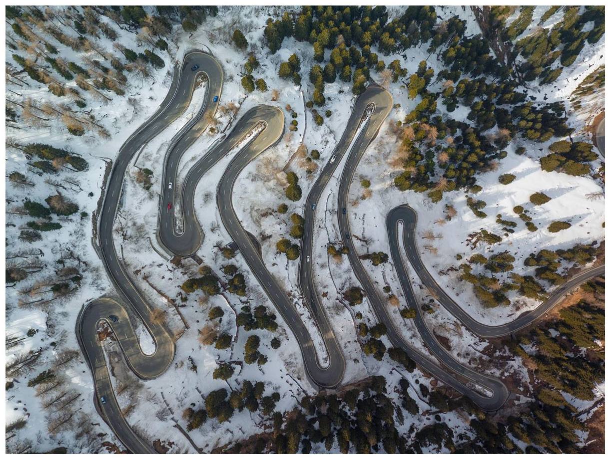
Top-down view: Defamiliarizing the familiar, Maloja Pass (Switzerland). © Rory, 2016.
The striking white snow accentuates the dramaticism of the road and even gives the surrounding forest of green and yellow larch trees a more ominous appearance, which is further emphasized by their shadows that add emotional intensity to the image (Ledin and Machin, 2020: 102). The disorderly arrangement of shapes, colours and contours creates a juxtaposition between intimacy and chaos, transforming the visual field in both vertical and lateral directions, which produces an unrecognizable perspective of an everyday image (Christiansen, 2020: 290). This makes the landscape feel more tactile than visual as the road, trees and snow bend as they approach the camera lens and move away from it again. This new organization of space in terms of tactility contributes to a reimagining of the top-down angle, allowing a new sensory formation to be enacted and, thus, a reperspectivization of image. Here, the camera is a partner rather than a medium of control or negative influence in the world-making process, producing a new visual syntax from the aesthetic and experiential changes to what we see and experience (Garrett and Anderson, 2018).
Top-down views: accessing the inaccessible
Many of the interviewed drone users also commented on the ability of drones to access inaccessible places and seek out what is hidden. They claimed that this was important for places that were dangerous to access or had difficult terrain and could have significant professional implications, such as in volcanology fieldwork to track open lava lakes or firefighting to map gas, smoke and temperature levels in an area before physically entering. In other cases, this ability had a purely recreational function, used to capture a never-before-seen view of a certain landscape, building or street scene and share it with others. According to several interviewees, when photographing these types of scenes, they favour the top-down angle because it enables a particular point of focus to be situated within a broader landscape. By showcasing how the different components fit together, they obtain a better understanding of the site and how it operates. Drone researchers have found that the top-down angle can also generate higher levels of mental stimulation and emotional response in viewers (Royo-Vela and Black, 2020 – something that was equally recognized by participants in the current study: Once I made [sic] a photo of a house in the village of my grandparents. The moment my grandma saw it, she burst into tears. ‘What happened?’ I asked her. She replied, ‘We’ve been living here for 45 years and I had no idea how beautiful this place is.’ At that very moment, I realized how extremely important it is to share my discoveries and findings, to show people how our world really looks like.
As the above quote illustrates, although the top-down angle is not always used for abstract art purposes, it still serves similar functions in its reperspectivization of landscapes by producing new understandings of spaces that are out of bounds or hard to access in real life. While Jablonowski (2020) sees such views as hierarchical and hierarchized ways of looking that divide the world into ‘those who are the rightful subjects and objects of the gaze’, Benjamin (2020) believes that these types of images, in fact, have a deterritorializing effect because they remove the drone’s association with the ability to bomb remote locations from a safe distance and instead allow us to inscribe previously unseen spaces with personal meaning.
A case in point is the image in Figure 2, which shows the ruins of St Mary’s Church in Tintern, Wales. The church was rebuilt on the site of a medieval chapel in 1866, which was closed in 1972 and subsequently destroyed in a fire in 1977. It sits on top of a hill in the village that is only accessible via a steep walking path and is marked with ‘dangerous building’ signs, warning visitors that they enter at their own peril. The drone is able to access this area from a safe, unrestricted distance, making the site approachable and offering a sense of intimacy as a window is opened onto the church’s personal space (Ledin and Machin, 2020: 50). Through its top-down angle and framing, the photograph offers viewers an illusion of exclusive access (Harrison, 2003: 48). This perspective makes visible a power structure (i.e. the Church) that typically operates through invisibility, thereby reversing the gaze in a symbolic sense or, as Paglen states, turning ‘the masters of surveillance’ into the ‘surveilled’ (cited in Wilkinson, 2013: 12). The camera flattens the church’s frame into a 2D cuboid net, which gives the image ‘low modality’ (Kress and Van Leeuwen, 1996: 164) and injects a sense of fiction into its reality; it is the space between these imaginary worlds that gives room to shifting perspectives on verticality.
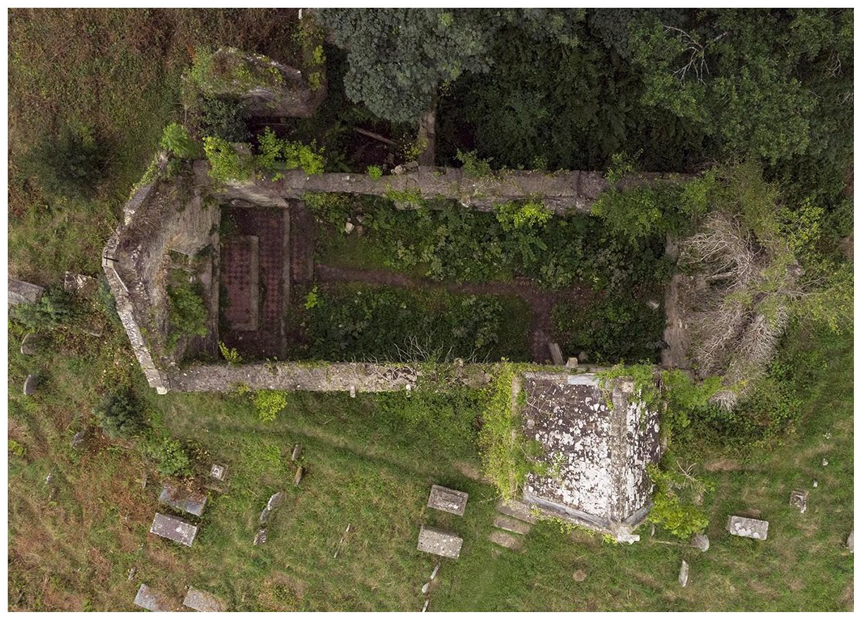
Top-down view: accessing the inaccessible, St Mary’s Church, Tintern. © Isaac, 2019.
The 2D perspective draws attention to the overgrown grass and weeds that have intruded into the church’s walls, floor and window, signalling a ‘bleeding’ of meaning (Ledin and Machin, 2020: 182). In this case, the defiance of spatial boundaries visually indicates the power of nature reclaiming the landscape, thereby directly challenging the omnipotence of the drone view as, here, nature is the ultimate victor. This victory of nature over man is further accentuated by the predominant green hues of the image, which contrast strongly with the dull greys and browns of the ruins (p. 98), as well as the lichen growth and acid rain damage on the tombs.
The top-down angle also captures some surviving elements of the original church, such as the red-tiled flooring in what would have been its aisle and altar. Although the drone’s ability to capture subtle details of the site’s geography could be considered as evidence of the unequal power balance between the view from above and below, here, this empowerment is divorced from omniscience because it grants viewers access to features they could not otherwise see, enabling them to counter surveillance. Thus, the mode of vision is presented as a new form of relational experience in which viewers are granted access to an inaccessible or ‘forgotten’ place, encouraged to suspend reality and embody the image and, thus, gain control over what they see (Brighenti and Pavoni, 2021: 430). In doing so, they redefine their relation to and perception of their surroundings, fostering a sensorial rather than purely visual experience that showcases the instability of meanings associated with the aerial view when applied to domestic drones and unsettles and reformulates our understandings of verticality (Richardson, 2020; Zuev and Bratchford, 2020).
360-degree panoramic views: enhanced visual experiences
Another important affordance of drones for many users is their multidirectional motility, which enables them to capture 360-degree panoramic views that offer enhanced visual experiences of nature, weather and landscapes. For some, these perspectives are important in drawing attention to the impact of human activity on nature while, for others, they are used to accentuate colours, textures and patterns in the landscape that give the images an air of mystery and intrigue. One interviewee described his aerial panoramas as ‘hero shots’ because they captured the ‘big picture’ of a location and highlighted the magnitude and impressiveness of nature. Many drone users also remarked on how 360-degree panoramic views had changed their everyday lives, noting that their walking experiences were enriched because they now thought differently about their surroundings. In other cases, the drone’s potential to foster a ‘reacquaintance with nature’ had positive mental and physical effects, helping one user battle his problems with agoraphobia and another to lose weight and become more active.
Bate (2009) describes panoramas as offering ‘a kind of mastery over the scene and, by implication, over nature itself’, which echoes some of the traditional concerns around unequal power relations associated with aerial views (Kaplan, 2018). However, drone panoramas are also democratizing in the way that they encourage a form of ‘performative cartography’ as our experience-based and location-oriented practices are performed through mapping and seen in an interactive 3D rather than flat 2D perspective (Verhoeff, 2012: 13). Thus, the panoramas present a dense material encounter between the drone, technology and the environment, which directly involves viewers and transforms the drone from a panoptic apparatus into a co-maker of visual material (Mikkola, 2020: 208). These elements operationalize a new mode of perception that foregrounds the drone as a complex material ‘assemblage’ of the sky (Crampton, 2016: 137), yet also emphasizes its ‘embodied objectivity’ as it is engaged in both action and affective motion in relation to its surroundings (Haraway, 2001: 191). In other words, the drone view allows us to ‘become answerable for what we learn how to see’ as our vision is dependent on our situated knowledge, thereby giving us control over the ‘god trick’ (Haraway, 1988: 583).
The image in Figure 3 is a characteristic example of the potential of 360-degree panoramic views to enhance visual experiences. It depicts a wide expanse of green and yellow fields in rural Ladby in Denmark, dominated by a dramatic skyscape. In traditional photography, compositions are framed according to the ‘rule of thirds’, with one third given to the sky and two thirds to the landscape to create visual harmony in the image (Krages, 2005: 9). But here, this order is reversed, with the sky occupying two thirds of the image, which adds depth and length to the lines of vision and imbues the place with a sense of drama and action. This reversal of the ‘rule of thirds’ also contorts scale, dwarfing the relative proportions of trees, houses and windmills, and thus creating an impression of vulnerability to the imminent storm (Ledin and Machin, 2020: 185). These feelings are underscored by the powerful blacks, blues and greys of the cumulonimbus storm clouds that sit as a heavy weight on the horizon, countering the positive associations of the bright and colourful fields with an atmosphere of foreboding (p. 99). The arched structure of the two layers of clouds visually resemble a mouth turned into a frown or scowl, while the white clouds that rise from either side of the central cloud’s edges appear like smoke steaming from the ears. Through these personifying features, the scene shifts from a still life image full of inanimate clouds to one populated with living beings, the weather being the agent responsible for making this change happen.
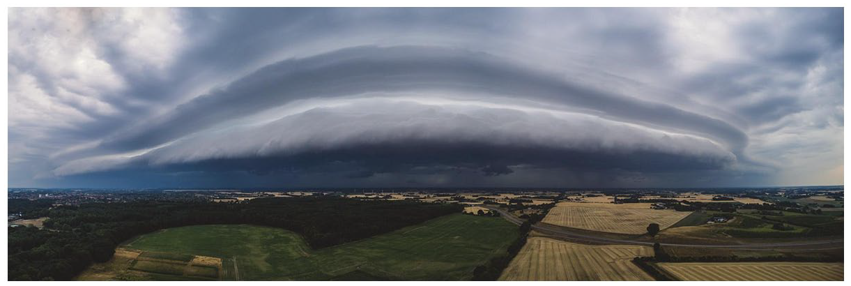
360-degree panoramic view: enhanced visual experiences, Ladby (Denmark). © Martin, 2019.
Like top-down views, 360-degree panoramic views are also highly sensory and tactile, and encourage a ‘more-than-optical’ view, which produces and reproduces multisensory knowledge, visual syntaxes and relations between sensed and sensing bodies (Jablonowski, 2020). Verhoeff (2012: 42) sees panoramas as a ‘scripting of performance’ because they solicit a performance from the viewer based on a script, defined as ‘the route along which the spectator is guided’. This is apparent in the above image, whose spatial composition informs how spectators are expected to look, move and understand what is seen. Through the clever use of colour, light and framing, the landscape is given a sense of movement that guides the mobility of the viewer’s gaze in the style of 19th-century dioramas or phantom rides. In this way, the 360-degree panoramic view becomes both a view and a mise-en-scène (p. 47). In other words, it offers up a photo that can be seen at a glance, while simultaneously indicating that its unfolding (and, therefore, its meaning) occurs over time. Its framing also suggests that all the elements of the scene are unified and belong together; thus, they are ‘staged’ based on their potential aesthetic effects (Ledin and Machin, 2020: 182). These elements make clear how panoramas are never static visual experiences but rely on a range of semiotic resources to encourage movement, tactility and materiality, thereby renarrativizing geography by bringing focus to the power of nature and creating alternative interpretations of familiar landscapes that transform seemingly mundane views into spectacular sights.
‘Classic’ landscapes: bird’s eye views and adherence to traditional aerial photography
The previous sections have drawn attention to the drone’s sophisticated technology and how it is shaking up our visual imaginaries, revealing secrets of our geographical surroundings and producing new and unexpected perspectives of the world. However, not all drone users take advantage of these technological affordances. In some cases, they rely instead on their knowledge of traditional aerial photography (e.g. low oblique angle, undistorted perspective, distorted relief) and adhere to these canons of use and their pre-established compositional rules when producing images. The interview data provides some indication that this is particularly the case for new drone users, suggesting that, as their confidence builds, they move onto more advanced forms of visualization. Another important consideration is official guidelines that constrain the movement, range and autonomy of drones. In the UK, for example, drones must not fly higher than 122m from the closest point of the earth’s surface, within 150m of urban spaces and residential areas, within 50m of people or within 5km of airports (Civil Aviation Authority, 2021). These limitations mean that users are constrained by rules of height and, therefore, tend to fly their drones in rural and remote areas, where they produce images taken from bird’s eye views instead of top-down perspectives or 360-degree panoramic views. Despite their less creative structure, these types of images are not to be regarded as simplistic; their ability to mimic the style of occupied aerial photography requires a certain level of skill and competence, while their layers of texture and colour differentiation show great attention to the meanings and impact of certain visual choices (Aber et al., 2010).
A prototypical ‘classic’ landscape photograph taken by a drone can be seen in Figure 4. It shows the Uffington White Horse – a 110m prehistoric hill figure situated on White Horse Hill in Oxfordshire, which is formed from deep trenches filled with crushed white chalk. The close-up view from the ground makes it extremely difficult to identify the horse, 1 yet from the air, its form is clearly recognizable. The image follows many of the standard recommendations for composition in aerial photography, particularly regarding its use of a low oblique angle, its relatively small area of coverage in a trapezoid shape, undistorted perspective, discernible but distorted relief, lack of horizon and inability to measure scale, distance or direction. However, it also shows affordances made possible by the drone camera’s high-quality optical zoom lens, which accentuates colour, texture and patterns in the landscape in a way that triggers strong emotional responses in viewers not attainable from the more distanced, detached and scientific perspective of traditional aerial photography (Agostinho et al., 2020: 25).
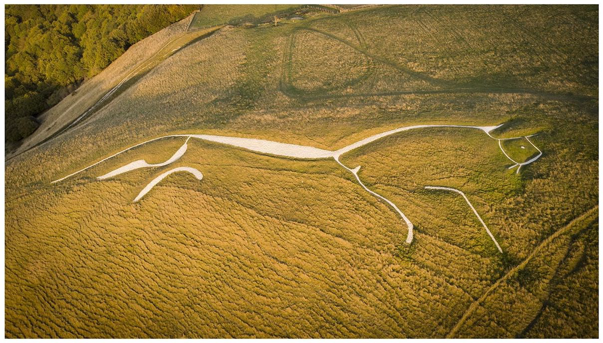
‘Classic’ landscapes: bird’s eye views and adherence to traditional aerial photography, Uffington White Horse (England). © Isaac, 2019.
Drury (1987) notes that stereoscopic colour vision is the most important human sense and, thus, the values and connotations of colour play an integral role in photography. This is apparent in the above image in which the yellow of the grass immediately catches the viewer’s eye rather than the white chalk horse. Yellow represents a ‘hot’ colour infrequently seen in nature (Ledin and Machin, 2020: 106) and, when viewed in parallel with the ‘cooler’ green of the grass in the background, they work together to create a ‘pseudo-depth perception’ that makes viewers feel closer to their surroundings (Aber et al., 2010: 63). The image depth is also accentuated by the juxtaposition of artificial linear (fence posts, paths) and natural curved elements (hills, trees), which add layers of profundity and create a visual conflict as the viewer’s gaze moves between the two patterns (p. 65). We can make out the gradient of the hill, which offers a clear sense of its steepness, as well as the angled trees, which indicate that the shot is taken in mid-air and, thus, encourage us to place ourselves into the same position of flight that a bird might occupy (Wilkinson, 2013: 10). This depth of field is further emphasized by the late afternoon sunshine, which forms shadows on the grass that produce a tonal contrast on the terrain relief. These features imbue the image with a 3D quality, showing that this perspective is attainable in more basic forms of photography and is not limited to 360-degree panoramic views (Aber et al., 2010: 58). The multiple layers of depth also give a sense of animacy and motion to the chalk horse as they capture its splayed legs, stretched tail and forward-facing gaze (Ledin and Machin, 2018: 58). The natural curves and colours in the image also change the appearance of the grass, imparting it with a distinct fabric-like pattern that evokes a spongy or woollen texture, thereby turning the viewing process into a highly sensory experience (p. 98).
Together, this combination of multiple visual elements creates an aesthetically-coherent, emotionally-charged photograph that, like top-down views and 360-degree panoramic views, offers opportunities for observers to embody the images and develop their own personalized aerial space that remakes their existing relationships with the world around them (Kress and Van Leeuwen, 1996: 41). Seeing, therefore, becomes a performance tied up with both symbolic and narrative processes and has the potential to produce ‘countervisuality’ (Monahan, 2018) as everyday features of a landscape acquire powerful new meanings that disrupt the ideological order of the view from above.
Conclusion
In recent years, the expansion of drones with embedded cameras has significantly increased the production and consumption of new visual perspectives (Garrett and Anderson, 2018). This study is the first to draw specific attention to the compositional structure of visuals produced by drone hobbyists, combining social semiotic analysis with ethnographic insights to assess how they are changing the way we think about the world. Specifically, it does so by adopting a sociocultural perspective with the aim of identifying the motivations and relationships between semiotic choices in drone visuals, their meaning-making practices and their sociocultural effects (Pink, 2007). Through this approach, this article emphasizes the importance of opening an interdisciplinary conversation about the ways that technological developments influence our visions, practices and understanding of the space in which we live. Our analysis has uncovered three frequently occurring characteristics of hobbyist drone visuals – top-down views, 360-degree panoramic views and ‘classic’ landscape perspectives – all of which are transforming sense-making processes and generating fresh narratives of our everyday life experiences.
The top-down view that drones afford can reveal patterns and shapes that the human eye is not able to perceive or grant access to places that are out of bounds or difficult to access. Moreover, this perspective can generate feelings of physical intimacy and proximity, placing viewers into the position of sight that the camera occupies, thus creating the sense that they are participating in an actual flight. This has the potential to challenge and deterriorialize traditional negative associations with the vertical perspective, thereby reframing the relationship between ground and sky. On the other hand, 360-degree panoramic views expand human vision and, in turn, expand our knowledge of the earth, fostering a dense and three-dimensional ‘sense’ (Brighenti and Pavoni, 2021: 430) that encourages viewers to engage deeper with their surroundings and interact with them in new ways. By disrupting traditional spatial composition and accentuating colour and texture, these images move beyond the visual and foster a tactile and sensory engagement with our surroundings, often imbuing them with a sense of drama and turning still photos into moving images. ‘Classic’ landscape perspectives, conversely, have more in common with traditional aerial photography and pre-established compositional rules in terms of their angle and area of coverage. Nonetheless, the drone camera is still able to produce emotionally charged images by juxtaposing natural and crafted elements in the landscape and exploiting the affordances of colour, texture and patterns to create pseudo-depth, and therefore challenge viewers to critically assess their relationship with their surroundings.
Overall, our study of photographs produced by drone hobbyists clearly demonstrates that drones are playing a pivotal role in our understanding of the world, their unanticipated angles and visions offering a new form of seeing from above with capabilities not offered by previous technologies. Furthermore, their widespread dissemination across social media and established online drone platforms means that they are becoming integrated into our daily lives, thus starting to form part of our visual imaginary. The novel perspectives afforded by their augmented vision are therefore (re)shaping our worldview, contributing new insights to our pre-established knowledge and experiences. We hope our study acts as a springboard for future research into the so far underexplored area of the semiotics of drone visuals. Greater attention to their multiple forms and functions will go some way to adopting a recuperative stance towards drones, showcasing their potential for artistic and creative purposes, and highlighting the strong relationship between semiotics, technological affordances and sociocultural effects.
Footnotes
Funding
This work was supported by The British Academy/Leverhulme Small Research Grant SRG18R1\180618. There is no conflict of interest.
Notes
Biographical Notes
ELISA SERAFINELLI works as Co-Director of the Digital Society Network and as a Research Fellow in the Department of Sociological Studies, where she is working on an AHRC Leadership Fellowship for the study of ‘Drones in Visual Culture’ and on a British Academy/Leverhulme small grant for the study of users’ and developers’ perspectives on drone usage.
Address: Sociological Studies, University of Sheffield, Western Road, Sheffield S10 2TN, UK. [ email:
LAUREN ALEX O’HAGAN is currently Research Associate in the Department of Sociological Studies at the University of Sheffield, where she works on the AHRC-funded project ‘Drones in Visual Culture: Developing a New Theory of Visual Mobile Communication’. Previously, she held Postdoctoral Researcher roles in the Department of Media and Communication Studies at Örebro University (Sweden) and the Centre for Language and Communication Research at Cardiff University, where she researched communication on healthy and sustainable foods, and class conflict in Edwardian book inscriptions, respectively.
Address: as Elisa Serafinelli. [ email: