
Abstract
This study examines navigation tools as key mediators of spatial perception, mobility, and digital infrastructures, contributing to scholarship on mediatization, geomedia, and surveillance studies. Navigation apps like Google Maps do not merely facilitate wayfinding; they actively shape spatial experiences, decision-making, and social interactions. Using a mixed-methods approach, we combined real-time activity tracking via the “MapRecorder” tool with qualitative interviews to analyze how users engage with Google Maps. Our findings reveal that navigation tools function as interfaces of spatial production, social connection, and data extraction, embedding themselves in everyday media repertoires. We identify four key usage patterns—search, place, directions, and map view manipulation—demonstrating that navigation is increasingly entangled with broader digital habits. In addition, the data suggested a paradoxical relationship between user convenience and concerns over dataveillance, contributing to debates on privacy resignation and the platformization of spatial control. By foregrounding these tensions, our study extends discussions on the deep mediatization of space, the role of geomedia in shaping mobility, and the sociotechnical power of digital navigation infrastructures.
Keywords
Introduction
The use of navigation devices and apps has become an integral part of daily life across the world. Navigation in this context refers to the coordinated and purposeful movement of people through their environment. It encompasses both the planning and execution of movements and consists of two main aspects: motion, that is, physical movement in the immediate environment, and wayfinding, which involves decisions about the route and orientation in the wider environment (Montello, 2005). Navigating from one place to another no longer requires road atlases or prior familiarity with an area; instead, mobile applications such as Google Maps, Apple Maps, and Waze provide real-time guidance, traffic updates, and additional contextual information. Google Maps, in particular, has emerged as the dominant platform, ranking among the most widely used mobile applications globally (AppMagic, 2021). In 2020, Google Maps was named one of the top apps Americans “can’t live without” (Statista, 2020). Studies elsewhere have found Google Maps to be the fourth-most-used application in terms of total usage time (Savino et al., 2020). Although Google Maps is the most widely used mapping application, Apple Maps, Waze, and OpenStreetMap are popular alternatives that feature similar user interfaces and functionalities (AppMagic, 2021).
With this growing importance of Google Maps and similar applications in mind, it is no wonder that “a significant body of scholarly work has emerged” that aims to shed light on the intricacies of locative media and geomedia (Wilken et al., 2019: 3). Locative media refers to digital technologies that integrate location-based functionality, allowing users to interact with space in new ways (de Souza e Silva et al., 2016). Geomedia, in turn, is a broader term that describes how media technologies shape, interpret, and construct spatial realities (Fast and Abend, 2022; Fast et al., 2024; Jansson, 2022). “Thielmann (2010) was one of the first to recognize geomedia as a new technological condition. [. . .] He proposed geomedia as an umbrella concept for grasping both “locative media” and “mediated localities” (Fast and Abend, 2022: 3; Fast et al., 2019: 90).
Since the “spatial turn” in media and communication studies has made geomedia an integral focus of the field (Fast and Abend, 2022: 2; Wilken, 2018: 22), scholars have explored how navigation tools not only facilitate mobility but also contribute to the mediatization of space, shaping how people engage with their physical surroundings (Hepp, 2016). As McQuire (2017) argues, navigation technologies function as infrastructures of spatial mediation, influencing what locations become visible, accessible, or prioritized within urban environments.
Despite these valuable contributions, there remain gaps in understanding how navigation tools fit into users’ everyday media repertoires. Previous studies have examined navigation technologies in the context of human–computer interaction (Brown and Laurier, 2012), software development (O’Beirne, 2017), and privacy concerns (Barnes, 2006; Draper and Turow, 2019). However, fewer studies have explored how users reflect on their navigation habits and how these tools shape spatial perceptions, social interactions, and concerns about data extraction.
This study aims to fill this gap by answering three main research questions:
Research Question 1 (RQ1). In what ways do users integrate navigation apps into their everyday media practices and decision-making?
Research Question 2 (RQ2). How do users reflect upon their use of navigation devices?
Research Question 3 (RQ3). How do users perceive and negotiate emerging technologies in digital navigation and mobility?
To address this, we employed a mixed-methods approach, combining data tracking via MapRecorder with semi-structured interviews to analyze real-world usage patterns. By integrating our findings into discussions of mediatization, geomedia, and surveillance studies, this study contributes to ongoing debates about the role of digital platforms in structuring spatial experiences and shaping everyday mobility.
There are various obstacles to researching the employment of maps and use of navigation tools. In particular, Google Maps limits access to data for researchers (Riegelsberger and Nakhimovsky, 2008). Although the reasons for this reticence are often understandable (e.g. privacy concerns, the need to protect shareholder value by keeping information from competitors), this results in a gap in understanding navigation tools from a media and communication studies perspective. Our aim is to examine the use of Google Maps in everyday life, yet “in its very ordinariness, the everyday evades capture and analysis” (Wilken and Goggin, 2015: 7). In order to nevertheless be able to capture “the most obvious and the best hidden” (Lefebvre, 1987: 9), in our case the everyday habits of locative media users, data is gathered by employing two different methodological approaches. By combining data generated through a “wrapper app” with interview data, we found that map use goes well beyond being directed from one place to another. The use of navigation apps is multi-layered and embedded in other types of information gathering. Although participants appreciate the benefits of Google Maps—in particular, real-time traffic information and additional info available, such as opening times of institutions, pictures, and reviews—there is a strong weariness when it comes to personal data being collected by Google and other tech providers.
Conceptualizing navigation tools
Our understanding of the media used in the process of moving from place A to place B also builds upon studies that examine mobile media. Even though there is often no explicit focus on navigation media (for example Kircher, 2011), they offer insights into attitudes and usage patterns of media within different spaces. Thus, Kircher (2011: 174) concludes that mobile media create meaning while on the move, “by making it possible to link one place to another as well as to other people.” In addition, navigation tools shape how people perceive their surroundings. Through an online image search, distant places can be visited without being physically present. With the help of online maps, users can get an overview of a place before they actually visit it or after they have already been there, and by looking at an (online) map, route conditions and the length of a future journey can be estimated.
Navigation tools, such as Google Maps, Waze, and Apple Maps, belong to a broader category of locative media, which are digital technologies that integrate location awareness into everyday activities (de Souza e Silva et al., 2016). However, while locative media encompass a wide range of applications—including geotagging, augmented reality, and location-based social networking—navigation tools are specifically designed to facilitate spatial orientation and movement. These tools do not merely provide geographic information but function as spatial interfaces that influence mobility patterns, decision-making, and social interactions (Jansson, 2022).
Navigation technologies provide two different dimensions of locations: the absolute location of a person, for example, a coordinate, and the relative location of the person, which includes the relationship between the person’s location and environment. Thus, online maps offer the potential to be understood as a source of information for actual and possible locations of an individual (Adams and Jansson, 2012: 302).
That said, Google Maps does not merely reflect the physical world but actively constructs spatial realities by filtering and prioritizing certain locations while omitting others. As platforms mediate spatial knowledge, they participate in what Jansson (2022) refers to as the infrastructuring of public space, shaping movement and access through algorithmic and commercial logics. In this sense, digital navigation tools exemplify how geomedia technologies condition everyday mobility practices within platformized environments (Fast et al., 2024).
Digital navigation services offer more functions than specifying the location and destination: photos of a visited place can be linked to a specific location on an online map (geotagging), other people’s photos can be commented on, and your own and other people’s photos can be shared on platforms. Thus, specific locations are discursively shaped. This aligns with Farman and Frith’s (2016: 142) argument that digital maps do not just guide movement but actively produce space, shaping the way users experience and interact with their surroundings.
In fact, Farman and Frith (2016: 142) talk of “producing” space, explaining that “we don’t simply enter a space; instead, the space is produced alongside our movements through it as embodied beings” as well as “through our everyday practices and the technologies that we use among such practices.” This indicates that navigation tools are not just neutral aids for orientation but mechanisms of spatial mediation that influence how places are accessed, understood, and navigated.
Perhaps ironically, mobile media and online map services have led to the fading of distinct and inherent meaning of places: trips can be planned and experienced in great detail—including evaluations of restaurants one might visit, recent pictures from museum exhibitions, and other points of (potential) interest—from the comfort of one’s home. Places can take on a different meaning at any time through the use of digital communication media. Thinking along the lines of Thompson (2011) and Adams and Jansson (2012: 309), the place where someone is positioned at the moment is overlayered with representations of other places the person is interested in. As Özkul and Humphreys (2022) suggest, this phenomenon introduces new temporalities into spatial navigation, as users interact with maps not just for immediate wayfinding but for social and exploratory purposes. As our results show, the interest in places can also have a social dimension—in that somebody explores an area via navigation tools because a family member or friend is staying there.
Google Maps works similar to other digital platforms in that it exchanges and processes data, generates patterns, and offers predictions (Felgenhauer, 2017: 119), thus providing topical suggestions for the least trafficked route to work, predict the waiting time at road works, or offer bypasses made possible by a high sum of usage data. Building on these perspectives, Özkul (2021) introduces the concept of the algorithmic fix to describe how location intelligence technologies aim not just to predict user behavior, but to stabilize and manage it. These algorithmic practices of placemaking contribute to what she calls “predictable futures,” where mobilities and identities are shaped through spatial sorting and automated inference.
As navigation tools integrate more AI-driven features, they also raise questions about user autonomy and data privacy (Draper and Turow, 2019; Jansson, 2022). Predictive analytics and automated route suggestions influence not only efficiency but also the extent to which users actively engage with their surroundings, as mobility decisions become increasingly shaped by algorithmic systems (JafariNaimi, 2018).
Given the potential of constant connectivity and omnipresence, navigation tools also represent and provide information on temporary occurrences such as traffic jams, accidents, or a high number of customers at a fitness club. These additional features—including information on opening times of shops and institutions and reviews of restaurants—make them much more influential in shaping urban mobility than traditional offline maps. As such, navigation tools are key actors in the negotiation between personal convenience, platform-driven mobility, and emerging automation in transport systems (Fast et al., 2019).
From the perspective of the providers, users allow for essential information to be transmitted as well. The navigation service Waze even employs the rhetoric of “community-driven data” collected in partnership “with cities, transportation authorities, broadcasters, businesses, and first responders” (Waze, 2023). First and foremost, of course, users serve the map provider by feeding them information. Local businesses, restaurants, and institutions such as museums also have an interest in being “represented” in navigation tools to increase their customer and visitor numbers. Circulating representations of places and geo-tagged images linked to user comments or reviews are adequate elements of travel: “One moves through a plethora of place representations, even as the body also moves through physical, material space” (Adams and Jansson, 2012: 307).
Twenty-five years ago, Sheller and Urry (2000) claimed that automobiles would become “hybridised with the rapidly converging technologies of the mobile telephone, the personal entertainment system and the lap-top computer” (p. 754). We can now see that their projections have come true. Going beyond contemporary cars and lorries, Sheller and Urry’s (2000) predictions also hold true for cyclists and pedestrians. In a hypermobile world, navigation tools have become an essential part of people’s media repertoire (Hasebrink and Hepp, 2017). Furthermore, with smartphones so strongly embedded into daily routines, the significance of navigation apps goes beyond the mere content and information they provide by impacting the most private and sensitive features of people’s lives (Pink and Leder Mackley, 2013). Thus, navigation tools can be conceptualized as a phenomenon of deep mediatization (Hepp and Hasebrink, 2018: 19).
However, previous research has pointed toward the ambivalence that users developed. Hamby et al. (2018: 1259) emphasized the following: [M]any participants expressed a fundamental skepticism about whether modern technology has really improved life and whether it has adverse effects on important cultural values, such as humility and modesty. Other concerns [questioned] whether technology was making people less self-reliant and whether the costs in losses of privacy were too high.
By situating navigation tools within the broader frameworks of mediatization, geomedia, and AI-assisted mobility, this study highlights how digital mapping technologies are increasingly entangled with platform governance, predictive algorithms, and issues of user autonomy. This perspective is particularly relevant given the growing reliance on navigation apps in emerging mobility infrastructures, from smart city planning to ride-sharing services and autonomous vehicles.
Methodological approach
In line with the research questions outlined above, data were gathered by first employing a map recorder, that is, a “wrapper” app (Carrascal and Church, 2015) that allowed us to trace people’s activities on Google Maps. This “wrapper” application for Google Maps called MapRecorder “wraps” the Google Maps mobile website and, therefore, allows researchers to capture rich behavioral logs while affording a very similar experience to the standard application. The wrapper follows the naturalistic application use of the popular operating system iOS to allow for an in-depth analysis of mobile map application behavior. It captured 4 weeks of usage behavior, totaling 483 minutes of interaction spanning 443 sessions. The average application session lasted 65 (median: 44) seconds. For the purposes of the present study, the wrapper app recorded all activities on Google Maps—from the moment of opening the app to the point where the research participants pressed the directions button in the app, which starts the actual navigation process. This approach allowed us to capture not only users’ wayfinding behaviors but also exploratory and decision-making processes related to map interactions, which aligns with our focus on navigation apps as part of broader media repertoires. In total, 28 participants downloaded the wrapper app.
In a second step, the data collection included a qualitative component of semi-structured interviews to understand particular usage behaviors during the study period. Participants were recruited through a combination of purposive and convenience sampling. Initially, we sought users with diverse navigation habits and varying levels of engagement with digital maps. Invitations were sent out through university mailing lists, social media, and word-of-mouth. While our sample included a range of professional and academic backgrounds, a majority of participants were students or individuals with research-oriented occupations, which may introduce a certain bias in terms of digital literacy and privacy awareness.
Eight of the MapRecorder users participated in individual, semi-structured interviews conducted via telephone or Skype. Our sample consisted of a group of three male and five female participants, ranging in age from 21 to 47. All of them were based in and around Bremen, Germany.
The focus on (future) mobility was particularly relevant to Research Question 3, as it allowed us to examine how participants perceive and negotiate emerging AI-driven navigation technologies and their implications for everyday mobility. To ensure participants’ reflections remained as close to their real experiences as possible, interviews were conducted within 2 weeks of the final MapRecorder tracking session. However, we did not ask participants about specific sessions, as it became clear that they could not recall details of individual interactions. Instead, the interviews aimed to explore general patterns in their navigation habits and their perceptions of digital mapping technologies.
The interview material was examined using qualitative content analysis, focusing on how the participants described their use of navigation apps, their media repertoires, and their concerns related to data privacy, AI-assisted navigation, and automation. The qualitative insights were then analyzed in relation to the behavioral tracking data, allowing us to triangulate findings and better understand the intersection between user practices and perceptions of digital navigation.
Finally, while this study provides valuable insights into everyday navigation practices, we acknowledge several methodological limitations. First, the sample size is relatively small (N = 28 for behavioral tracking, N = 8 for interviews), which limits the generalizability of our findings. Second, as noted, a majority of participants had an academic or research-related background, which may influence their digital literacy and attitudes toward platform governance and privacy. Third, because participation required downloading an external app, our sample may be biased toward individuals who are more comfortable experimenting with digital tools. Future research should aim to expand the participant pool to include a wider range of professional and demographic backgrounds and explore longitudinal trends in navigation app usage over time.
Contextualizing the use of navigation tools
In this section, we first highlight the main results gathered from the analysis of data obtained through MapRecorder. In addition to the obvious focus on app usage, these results are additionally concerned with the temporal aspect of navigation, that is, how much time is spent on which navigational activity. Özkul and Humphreys (2022: 2550) have recently highlighted the need for a “temporal turn” in geomedia studies, arguing that the spatial turn of the 1980s has thus far undermined academic considerations of the temporal aspects of locative media. Consequently, these aspects have remained “relatively understudied” (Özkul and Humphreys, 2022). The following results demonstrate the close web of temporal and locative dimensions concerning navigation in everyday life. Second, we outline the key results from the semi-structured interviews, including that (1) the use of navigation tools goes well beyond actual navigation, (2) the process of locating a place and its connections is embedded in a wider media repertoire, and (3) concerns about dataveillance and the future of mobility supported by artificial intelligence cause a sense of ambivalence and overwhelm users.
What do users do with Google Maps and for how long?
To describe people’s activities on Google Maps, we distinguished among four activities:
Search, place, directions, and map view manipulation. In our framework, the search phase begins once a user starts typing a search query and lasts until they are redirected to a result, either by choosing one of Google’s auto-complete results or by immediate redirection after hitting “enter.” The place phase covers the time users take to choose a place icon on the map or to be redirected to a place (e.g. a restaurant or neighborhood) after a search. The user leaves the place phase when they either click on the map directly (discarding the place information) or they begin the direction to a place, which triggers the directions phase: looking up routes between a start and goal location. The phase map view manipulation (MVM) includes all interactions with the map that a person carries out to manipulate the map view, for example, panning, zooming in and out, and viewing the map.
Looking at the results of the MapRecorder application study, we see a pattern of usage. When analyzing the average session phases (search, place, directions, and MVM), we found that users spent around 67.5% of the length of a session in the MVM phase, 21.1% in the directions (D) phase, 8.2% in the place (P) phase, and the remaining 3.2% in the search (S) phase.
These findings indicate that users engage with Google Maps not only for navigation but also as a spatial interface for exploration and decision-making. The dominance of the MVM phase suggests that Google Maps is not merely a wayfinding tool but also a means for users to interact with and make sense of space before actual physical movement takes place. This supports McQuire’s (2017) argument that digital mapping tools do not just represent space but actively construct it, shaping how users visualize and anticipate their movements.
The average session statistics for all users are included in Figure 1. Further analysis revealed a repeated usage pattern across sessions by different users across the data set. When looking at the user transition between phases, we discovered that MSPD (Map-View manipulation, search, place, directions) is a typical session pattern. The two most common sequences were MSPD (12.1% of all sessions) and MD (Map-View manipulation and directions; 13% of all sessions). In the case of the MSPD pattern, the users typically started by examining the map for a short amount of time (MVM); they then began to enter a query into the search bar (S). After issuing the search request, they were then redirected to the place where they were searching (P). Finally, they used the directions button to bring up the directions menu for the currently active place (D), usually to navigate from their current location. The data show that almost 50% of the duration of each session recorded was spent on exploring the map by zooming in and out, panning, and viewing the map. We interpreted this as an indication of the use of Google Maps going beyond assisting people in navigating from point A to point B (Bellino, 2015; Savino et al., 2020).
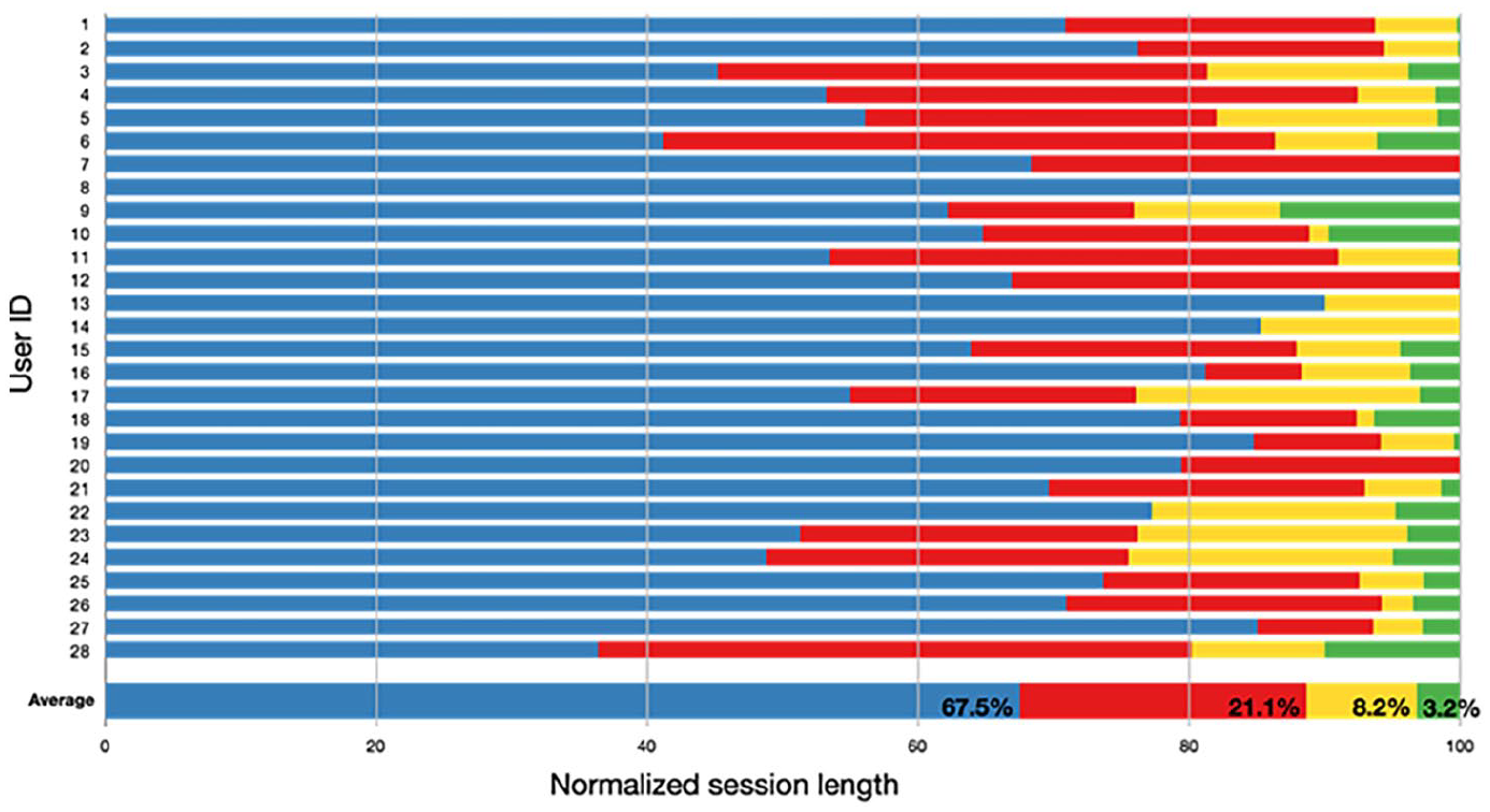
Distribution of map usage phase for all users and averaged over all users. From left to right: Map-View Manipulation (Blue), Directions (Red), Place (Yellow), Search (Green).
Auto-complete was used in more than 50% of all searches, making it a nontrivial part of mobile map applications. The way an application suggests autocompletion can largely influence the user experience. Because local users most likely do not need generic results, auto-complete could suggest places based on previous locations, preferences, or patterns of use, whereas for a nonlocal user, it should probably push the auto-completion for entity classes to better assist the user within the context of use.
Also, although we found a typical pattern of phases (MVM, search, place, directions), two participants (see No 13 and No 14 in Fig. 1) never used the search function within the app. Others used the search function only very briefly. One explanation might be that users employ other apps for more complex queries (such as “best vegetarian restaurant in Bruges”) to also have access to information from sites like TripAdvisor or travel blogs.
This sequential behavior highlights the exploratory nature of Google Maps, where users rely on digital cartographies to make sense of urban environments before physically engaging with them. This aligns with Jansson’s (2022) discussion of geomedia as not merely representing space but structuring spatial imaginaries through algorithmic mediation. Our findings concretize this perspective by showing how Google Maps’ affordances—particularly map view manipulation and auto-complete—guide users’ exploratory behaviors and anticipate their spatial decisions. In Jansson’s terms, this exemplifies the logistical affordances of geomedia: users are not just navigating space, but engaging in a form of everyday logistical labor, where their movement, attention, and decision-making are subtly shaped by platform logics. This strengthens the argument that navigation tools serve not just as representational or connective media, but as infrastructural interfaces of logistical accumulation.
Additional benefits of Google Maps
Furthermore, the amount of time spent with MVM can be contextualized with the help of the interviews conducted. Regarding their exploratory behavior on Google Maps, one interviewee explained, “I just recently [. . .] explored the [online] map, because my parents moved, and I didn’t know the neighborhood very well and then I just looked around” (Maria, 26, intern). Another interviewee reported that she explored a certain area for quite some time via Google Maps because her friend was currently on holiday there and she wanted to find out more about the place. This social use of navigation tools points to what Özkul and Humphreys (2022: 2561) describe as “a kind of temporal closeness” made possible by geomedia like Google Maps. By exploring the holiday location of her friend in this way, the interviewee creates “a sense of simultaneity” (Özkul and Humphreys, 2022). In other words, she can create a connection to her friend from a distance and simulate a shared experience without actually taking part in it.
The possibility of virtually exploring and getting to know places and going on mobile sightseeing tours without actually being present also allows a new perception of places and space and is an additional benefit to the actual service of online navigation systems. The interviewees described several features of Google Maps as particularly useful, such as reviews for restaurants and bars and the option to, for example, look at their websites and menus directly: “[I also use Google] if I’m just looking for the nearest ATM or a good restaurant. [. . .] And then you can immediately have a look at reviews and stuff” (Maria, 26, intern).
This quote demonstrates how Google Maps not only facilitates navigation but also actively participates in the social production of place, the temporal structuring of their day and their routes, and decision-making by influencing perceptions and experiences of urban environments.
Users benefit from the additional information Google Maps holds besides mere route planning regarding points of interest, such as opening hours, reviews, or suggestions of other points of interest within the route or one’s location. They can choose from the variety of transportation modes Google Maps offers. Besides car-, bicycle-, or walking connections, “[y]ou can also look for the bus or subway connection” (Antje, 26, research assistant).
In addition, participants emphasized the importance of real-time traffic data, which allows them to adapt their travel routes dynamically. This real-time responsiveness reinforces Google Maps’ role not only as a navigation tool but as a predictive mobility service that actively influences users’ transportation choices (McQuire, 2017): It happens to me quite often that when I go to the university I already opened the app and watched the earlier buses’ arrival times and I keep checking it because in the past ten minutes there were always delays [. . .] so I always check in five or ten minutes before and see if there are any discrepancies. (Tabea, 26, student)
This real-time information can affect the choice of transportation mode or influence the chosen route: “If [the traffic] is bad, I zoom in a little bit and check what the city center looks like an estimate whether a ride through the city might be faster” (Antje, 26, research assistant). Google Maps, therefore, is used for microcoordination (Ling and Lai, 2016) as it helps users not just with knowing where they are, but also where they are going to be at a specific time and how to coordinate the available (transportation) services to get there. Such features illustrate how navigation apps function as sociotechnical infrastructures that shape everyday mobility behaviors, aligning with research on the platformization of urban mobility (Halegoua, 2020).
Navigation as part of a wider media repertoire
Although the interviewees appreciated the benefits of using Google Maps, they simultaneously expressed mistrust of navigation systems, such as built-in car navigation software. One participant said, “Recently, I went to the Netherlands and the [navigation device in the car] tried to send me elsewhere so I use Google to check on the suggested route and if it makes any sense” (Antje, 26, research assistant). However, participants also did not fully rely on mobile navigation apps alone. While most interviewees acknowledged the convenience of smartphone-based mapping services, they also recognized the limitations of single-platform reliance. Although some participants kept paper maps in their cars, they noted that these often lacked the level of detail required for unfamiliar locations. In addition, paper maps are considered inconvenient to store and to carry around: “I mean, who has a stack of maps at home if you can have that on your smartphone?” (Manuel, 24, student). Consequently, our data show that users engage in what we call “navigation stacking” when planning a trip: traditional maps are used, as well as navigation apps on mobile devices, and beforehand, the route is planned using a navigation web service on a computer to check that the options given are optimal: So in the car, I have a TomTom. [. . .] I then use Google in between because sometimes the routes are a little different or you want to see if actually the map is the way the navigation system sends you and if it makes any sense. (Antje, 26, research assistant)
All interviewees demonstrated an awareness of the limitations of navigation tools, referring to instances of inaccurate information and emphasizing the importance of not placing unquestioned trust in navigation tools.
The described pattern of cross-checking also highlights the complexity of contemporary navigation practices, where individuals employ multiple tools to cross-check information rather than relying on a single system. This aligns with Hasebrink and Domeyer’s (2012) concept of “media repertoires,” where users strategically assemble different media and technologies based on their situational needs. Users actively construct their own navigational strategies, balancing algorithmic recommendations with personal knowledge and alternative information sources like radio, public transport apps and personal knowledge of their surroundings.
If participants have local knowledge, they will also juxtapose their own past navigation experiences with the information currently received through the devices mentioned. People, thus, devise strategies on the best way to navigate, keeping in mind the information they require, their personal knowledge of a locale, and the sources of information and devices available to them. Especially when driving by car, live traffic updates on the radio also provide essential information. The same holds true for different apps—the information provided by Google Maps might be contrasted with updates from local public transport apps. Cross-checking information across different apps and media can be interpreted as a subtle form of resistance—an attempt to circumvent the platform designers’ intention to keep users continuously engaged within a single app ecosystem.
Concerns about data, privacy, and future mobility
A third topic that transpired through the interview material was that of data security. In particular, tracking services were considered with a degree of ambivalence. On one hand, they simplify navigation and support participants in their everyday lives. On the other hand, the participants were not certain that their data was handled in an ethical and responsible way. One participant stated, “I’m really ambivalent about the insane support I have through such [navigation apps] and the loss of self-control and that feeling of being remotely controlled” (Beate, 47, employee).
This tension between convenience and control aligns with discussions on “digital resignation” (Draper and Turow, 2019), where users are aware of potential privacy risks but continue to use digital services due to their perceived indispensability. While previous studies have primarily examined this phenomenon in relation to social media and e-commerce (Marwick and Hargittai, 2018), our findings suggest that navigation tools contribute to similar patterns of user dependency and acceptance of surveillance. Participants perceived data privacy management as a personal responsibility, something they somehow needed to take care of for themselves. Regarding data privacy, we encountered two recurring narratives in the interview data. First, users had either “given up” or tried not to think about their digital traces any longer. As one interviewee stated, “Since I got a smartphone, it is just very handy and that outweighs my concerns about the data being recorded” (Matthias, 21, student).
The second narrative encompasses some form of resistance or “minimal data” strategy. This meant that interviewees would activate the geolocation service of their smartphone as little as possible: “[The GPS in my smartphone] bothers me and I turn it off” (Tabea, 26, student). The participants also described moving from one narrative to the other and being unsatisfied with their strategy of data privacy: I think Google Maps is great. I actually use it all the time. The only thing that cannot be prevented, in the past, I did not like to always track my location. However, now I don’t care; I don’t want to know how much data Google has about me. I used to have a bigger problem with that. By now, I’m too pragmatic, I don’t think so much about it anymore. (Maria, 26, intern)
This phenomenon may be recognized as a form of the “privacy paradox,” following the idea that, although users claim to be concerned about the privacy of their personal data when using online services, they act in a contradictory manner (Barnes, 2006; Kokolakis, 2017: 122). Moreover, they do not take any measures to protect their personal data. Seemingly, the benefits and convenience that Google Maps offers prevail over their concerns. Other explanations for this behavior vary from the lack of information on the users’ side, who do not know how data are collected and processed (Dommeyer and Gross, 2003; Park, 2013), to rational cost–benefit analyses of users weighing risks (e.g. Westin, 2003; see also Draper, 2017; Hoofnagle and Urban, 2014). As our data suggest, this paradoxical behavior might be a strategy for users to cope with the frustration that every interaction with Google Maps could be saved and processed. Draper and Turow (2019) coined the term digital resignation, which alludes to the feeling of powerlessness in data privacy management. This goes well beyond navigation services but is viewed in line with their media use as a whole. One interviewee summarized this as follows: I’m always, I mean, when using Google, I’ve always been a bit wary of my data [. . .] I just think this feeling that anyone or anything is traceable, everything I’ve ever looked at online . . . I do not like it that way, but I’m just over it, because what should I do. (Beate, 47, employee)
Hoffmann et al. (2016: 2) argued that when users feel overwhelmed by the control of institutions on their personal data, they develop “an attitude of uncertainty, powerlessness, and mistrust” about how their data might be processed, which results in making any effort to protect personal data obsolete. This leads to feelings of resignation (Draper and Turow, 2019: 5). The following statement by a research participants underlines this sentiment: I think much more data cannot be produced. Rather, what you can conclude from all these data will be a problem in the future [. . .] They [referring to tech companies] already know where we are everywhere anyway. They can already look into your phone, motion profiles, and so on. (Antje, 26, research assistant)
While technological advancement correlates with more data being collected, stored and processed, research participant Antje cannot fathom the collection of more data as she already feels like tech companies have a great deal of information about her through the digital traces she leaves behind. This sentiment mirrors what de Souza e Silva et al. (2016: 7) purport about the interrelated nature of locational privacy and safety: “The problem [. . .] is that locational history, when archived and linked together, is very telling about a person’s life and habits” and “can have serious consequences if misused.” As such, Antje’s worries about the extent of information tech companies already have on her are indicative of the wider issue of pervasive dataveillance and the consequent importance of locative privacy.
Especially with respect to technological innovations within the realm of mobility, concerns about data security and personal safety arise. Automated navigation, self-driving cars, and the employment of AI in mobility services in general will impact our social and individual lives. Drivers might be safer (Winkle, 2016), will not harm the environment (Davila and Nombela, 2012), and “free up time for people to work, socialize and use infotainment during automotive travel” (JafariNaimi, 2018; Kun et al., 2016; Pink et al., 2018: 616). The participants in the present study, however, exhibited a more cautious perspective: I think that’s not a nice thought, because to me it feels like I’m giving up control [. . .] I cannot imagine that. I think autonomous vehicles will be a thing, but I am very, very hesitant. (Beate, 47, employee)
Abdicating control and feeling powerless were common themes when it came to discussing the future of mobility. In addition, the interviewees were also concerned that it was the same few companies offering navigation services that were already dominating in other areas of their mediated lives: One more thing would be that they can analyze driving behavior and somehow, piece by piece, the whole circumstances of our lives. I mean, data are released all the time, the big tech giants get more and more of our data. (Tabea, 26, student)
This statement reflects anxieties about the increasing centralization of digital mobility platforms, where a handful of major companies control access to spatial data, transportation networks, and navigation technologies (Fast et al., 2019). Rather than acting as neutral wayfinding tools, navigation apps are embedded in larger corporate strategies that shape how movement is orchestrated and monetized. These findings suggest an underlying sense of exclusion from the collective imagining of future societal developments. Users appear to be positioned less as active participants in shaping or deliberating possible futures, and more as consumers within a preconfigured system. This may contribute to a broader dynamic in which individuals are rendered as commodified, able-bodied subjects rather than engaged and diverse citizens (Schulze, 2021; Jasanoff and Kim, 2015).
As these services continue to evolve, it is likely that users will face further dilemmas about trust, agency, and privacy in their interactions with AI-driven navigation. While participants valued the efficiency and ease provided by Google Maps, they also expressed unease about how these conveniences come at the cost of increased surveillance and a reduction in personal control over mobility decisions.
Conclusion
Summing up, this study brought several insights: We were able to identify complex usage patterns while examining the whole corpus of data collected during this two-stage study. The number of MVM sessions helped us understand the significance of an open exploration of the map—an activity that can be likened to physically strolling through a city or exploring an unknown area. Participants engaged with maps not only out of necessity but also out of curiosity, as reflected in the high usage times in the MVM phase. This supports previous findings that exploratory search is a widely adopted behavior when seeking spatial information online (Kraak, 1998) and that users actively enjoy panning and zooming through digital maps to interact with their environment (Bellino, 2015).
Google Maps extends beyond mere navigation, functioning as a spatial and temporal interface that shapes users’ mobility and decision-making. Participants did not only rely on directions; rather, they incorporated a variety of informational layers—including restaurant reviews, business hours, and real-time traffic data—into their decision-making processes. This aligns with research on the platformization of mobility, where navigation apps do not merely facilitate movement but also curate and structure spatial experiences through algorithmic filtering.
While our findings show that navigational systems actively shape rather than merely support spatial practice, they further corroborate Özkul and Humphreys’ (2022) argument that the temporal dimensions of geomedia remain underexamined. While their oral history interviews uncover the latent importance of rhythm, synchrony, and temporal coordination in mobile media research, our study provides empirical evidence of how these temporalities manifest in contemporary navigation practices. For example, our interviewees’ reliance on predictive arrival times, real-time rerouting, and the expectation of “always-on” guidance illustrates what Özkul and Humphreys describe as “mobile rhythms” and “zones of intermediacy,” where mediated time is both produced and experienced. In particular, the use of Google Maps as part of a larger repertoire of navigation tools and services demonstrates how digital navigation systems do not merely assist movement but shape users’ experience of time—through immediacy, anticipated duration, and synchronization with other users or infrastructure. In this sense, we extend Özkul and Humphreys’ focus on early mobile phones into the domain of mature, platform-based navigation, showing how temporal affordances have become increasingly prescriptive. As such, the normalization of platform-based navigation can also be read as part of a broader regime of behavioral modification, where user actions are subtly shaped to serve data extraction and optimization—a dynamic Zuboff (2019) identifies as central to the logic of surveillance capitalism.
This prescriptive dimension also resonates with Fast et al.’s (2024) conceptualization of geomedia as a sociotechnical regime—one that not only structures contemporary mobility but also configures future expectations about how movement should occur. From this perspective, navigation apps do not simply optimize travel; they contribute to a regime of “geomediatization realism” in which logistical efficiency and algorithmic guidance become naturalized features of everyday life. Our findings suggest that such apps function as infrastructural imaginaries, subtly foreclosing alternative temporalities—such as pause, detour, or serendipity—in favor of platform-aligned futures. This underscores the need to read navigation platforms not just as technical tools, but as key agents in shaping what Fast et al. (2024) call “geomedia futures.”
There is, however, not only one pattern that can grasp how Google Maps is used. As Figure 1 shows, we were able to display and unravel different activity packages that took place when using Google Maps. The comparison of these user profiles demonstrates that Google Maps usage is shaped by a variety of contextual factors, including users’ own local knowledge, eating preferences, hobbies, transportation modes, and the specific devices they use. Rather than functioning as a one-size-fits-all tool, Google Maps is embedded within individualized media repertoires (Hasebrink and Domeyer, 2012), reflecting how users integrate multiple sources of spatial knowledge when navigating.
The issue of privacy is deeply ambivalent: while some users explicitly questioned the extent to which Google Maps collects their personal data, others accepted the trade-off between usability and surveillance. This aligns with recent debates on privacy cynicism and user agency in locative media (Hoffmann et al., 2024), where users are increasingly aware of surveillance mechanisms but feel constrained by the necessity of digital services. Navigation tools blur the boundaries between public and private space (Adams and Jansson, 2022) and contribute to a growing sense of algorithmic governance over individual mobility.
This “tech weariness” observed among participants was not necessarily based on specific negative experiences but rather on a growing awareness that they are “paying” for convenience in ways they cannot fully grasp. This suggests that user agency in digital navigation is increasingly negotiated between perceived benefits and an underlying distrust of automated spatial systems.
Although users appreciated the benefits of an app like Google Maps, they were highly critical of AI-assisted mobility in general. There was a strong sense of not only giving up control over one’s geolocation and other data (such as all online activities), but also of abdicating power and losing agency. These fears were not specific or based on some form of evidence that spread from losing control over their data over to their mediated life in general to future technological advances. Rather than being served, the participants were aware that they might receive some benefits and ease while they were also paying in ways they could not fully fathom. This general “tech weariness” meant that, in most cases, they just gave up completely because no promising individual strategies on how to deal with this issue could be found. Given the small sample size of this project, future research should expand on these questions with a larger and more demographically diverse participant pool. In addition, longitudinal studies could explore whether user attitudes toward AI-assisted mobility evolve over time, particularly as autonomous navigation technologies become more mainstream. Future research could also examine how different demographics—such as older adults, non-digital natives, or users in regions with limited mapping infrastructures—engage with navigation tools and whether their privacy concerns differ from those observed in this study.
Footnotes
Acknowledgements
We would like to thank Karin Kuzmanov for her support and her valuable input.
Declaration of conflicting interest
The author(s) declared no potential conflicts of interest with respect to the research, authorship, and/or publication of this article.
Funding
The author(s) received no financial support for the research, authorship, and/or publication of this article.
Ethical considerations
Informed consent was obtained before participation by downloading the wrapper app—with all necessary information provided in writing. For the interviews we recorded verbal consent of interviewees.
Data availability statement
The data is currently not publicly available due to the nature of the information gathered (wrapper app combined with phone interviews).