
Abstract
The conventional accounts of the history of the sovereign state system assume that territorial sovereignty originated in Europe and spread to the rest of the world through colonial expansion. This implies that territory, which is a core feature of the modern state, and more specifically, linear borders, had not existed outside Europe before other societies encountered the West. Focusing on early modern Japan, this article challenges that assumption by showing that there was a similar territorial order outside Europe that developed in parallel with its European counterpart. Through an investigation of boundary disputes, boundary markers, and map-making during the Edo period (1603–1868), it demonstrates that linear borders were not foreign to early modern Japan. Domains in Edo Japan were already well into the process of building a territorial order with demarcated borders and mutual exclusion. This article contributes to International Relations scholarship by addressing the “Westphalian myth” from a geographical rather than temporal perspective and shifting the focus of the study of non-Western international systems from differences to similarities. It also suggests a potential revision of scholarly understandings of discontinuity before and after the Meiji Restoration in Japan.
Introduction
The number of sovereign states, which students of International Relations (IR) consider as basic units of analysis, totals nearly 200 today. This number is believed to have been far smaller; according to the Correlates of War dataset, there were only 23 entities that qualified as states in 1816, 1 year after the Congress of Vienna. 1 Scholars believe that territorial sovereignty originated in Europe and that the rest of the world was incorporated into the sovereign state system through colonization and decolonization (Bull and Watson, 1984; Spruyt, 2005). Before the arrival of European colonizers, people outside Europe lived in various political entities, including empires, tributary states, and tribal structures (Kang, 2010; Spruyt, 2020; Suzuki et al., 2014). Although there was considerable diversity in their forms, these polities had one thing in common: they were not sovereign states.
A central feature of the sovereign state is a territory that is clearly defined by linear borders. Therefore, as non-sovereigns, non-European polities before they encountered European powers have largely been thought to lack ideas and practice of territory. Although some recent scholarship has investigated the development of different aspects of territory, pointing out that some are not unique to Europe (Branch, 2014; Goettlich, 2019; Kadercan, 2017), scholars still largely assume that linear borders did not exist outside Europe until the age of colonialism. Unlike in Europe, this view posits that authorities in the rest of the world exercised political rule over people, rather than lands, and space was a collection of places, not an area demarcated by borders. Only after Europe developed the sovereign state system and expanded into the rest of the world did non-European polities begin to acquire the traits of the sovereign state.
However, the conventional understanding of the history of the sovereign state system has recently received criticism. In addition to works that debunk the “Westphalian myth” by showing that the Peace of Westphalia in 1648 had little to do with modern sovereignty and that Europe itself integrated fully into the sovereign international order only in the 19th century (de Carvalho et al., 2011; Osiander, 2001; Teschke, 2003), scholars have highlighted the well-known Eurocentric bias in IR (Acharya and Buzan, 2010). There has been little research on historical non-European polities, particularly in the context of the emergence and expansion of the sovereign state system. Therefore, the “Europe first, non-Europe later” thesis is less of an established historical fact than an assumption that needs to be tested by empirical evidence based on an examination of actual cases.
Against the backdrop of these recent developments, this article investigates with historical evidence whether the development of territory demarcated by linear borders was unique to Europe focusing on the case of Edo Japan (1603–1868). Following historians of Japan, it sees early modern Japan as an international system whose basic units were domains that retained significant autonomy from the Tokugawa shogunate (Howell, 1998; Ravina, 1995). It demonstrates that even before the modern period, Japanese domains were already well into the process of building a territorial order in which linear borders separated units.
This article contributes to the existing scholarship in three ways. First, together with recent studies on the timing of the consolidation of the sovereign international order, this study revises a conventional assumption of the history of the sovereign state system. It debunks what can be called the “geographical Westphalian myth,” namely, the argument that the development of territorial sovereignty only occurred in Europe (or outside Europe under European initiative). It shows that the consolidation of territorial rule did not necessarily occur first in Europe and then in Asia; it was sometimes a parallel process that occurred roughly during the same period. By showing that the changes that occurred after an encounter with European powers were not as drastic or fundamental as previously assumed, it prompts a revision in the understanding of territorial order outside Europe. It also advances our knowledge of international orders in history by acknowledging more agency of non-European actors. Second, it has implications for the non-Western IR literature. While much of recent non-Western or global IR scholarship focuses on differences between European and non-European international systems, this article shifts attention to their similarities. 2 Rather than arguing that existing theories do not apply to cases outside Europe, it demonstrates that a core characteristic of an international system thought to be unique to Europe existed in a non-European society, casting doubt on the precedence and uniqueness of the former. It thus offers an alternative way to approach the issue of Eurocentrism in IR. Third, the findings of this article have implications for viewing Japan as one of the first non-European members of international society. Although Japan’s successful adaptation to the European sovereign state system has been seen as a result of its drastic Westernization in the modern period, this article suggests that the preexistence of a similar system during the early modern period may have played a role as well. It implies that at least in terms of spatial understanding, the early-modern and modern periods were not as discontinuous as previously thought.
The remainder of this article proceeds as follows. The next section reviews the existing literature on state formation and the expansion of the sovereign territorial order, identifying a gap therein. Following a brief overview of the making of territory in Europe in the second section, the third section discusses the methods and case selection. The fourth section offers a case study of territorial order in early modern Japan.
Territorial sovereignty outside Europe
In IR, most scholars accept that territorial sovereignty originated in early modern Europe. Authoritative studies on the emergence of the sovereign state focus exclusively on developments in Europe, tracing the historical process of the transformation of feudal rule into modern government (Spruyt, 1994; Tilly, 1992). After the establishment of the sovereign state system in Europe, the rest of the world was incorporated into it mainly through colonialism, or more generally, an encounter with the Europeans (Bull and Watson, 1984). 3 Following their encounter with European powers, non-European societies are thought to have experienced a fundamental change in the idea and practice of the state, space, and authority, which completely transformed the existing political systems (Thongchai, 1994). As Zarakol rightly points out, “[t]he idea that the concept of sovereignty emerged (first and exclusively) in Europe is so ingrained that most scholarship dealing with this issue does not even specify that its arguments are derived from European materials only” (Costa Lopez et al., 2018: 506).
The prevalence of this conventional understanding arguably has much to do with the fact that the history of territorial sovereignty in non-European societies has generally received much less attention than that in Europe. Most studies on the history of the sovereign state system have focused on European cases, while works on state formation in former colonies have tended to focus more on issues regarding the development of state capacity and the penetration of the society by the state after independence than the change and continuity of international orders before and after the arrival of European colonizers (Centeno, 2002; Herbst, 2000; Kohli, 2004). As a result, they too have largely accepted the conventional understanding that territorial sovereignty never existed outside Europe before European expansion.
However, a new wave of studies on non-European polities before contact with European powers and their entry into international society has recently addressed this lack of research on non-Western international orders (Fawcett, 2017; Kadercan, 2017; Kang, 2010; Kwan, 2016; Neumann and Wigen, 2018; Phillips, 2021; Phillips and Sharman, 2015; Ringmar, 2012; Schulz, 2019; Sharman, 2019; Spruyt, 2020; Suzuki, 2005; Suzuki et al., 2014; Womack, 2012; Zarakol, 2022). They have pointed out that diverse forms of international orders existed outside Europe, sometimes even coexisting with the European sovereign state system until very recently. Thanks to these studies, we are becoming increasingly aware of “the central role of non-European agency in shaping global history” and have begun to revise “conventional narratives revolving around the ‘Rise of the West,’ which tend to be based upon a stylized contrast between a dynamic West and a passive and static East (the rest)” (Suzuki et al., 2014: 1).
Despite the significance of this recent development, however, most of these works of non-Western IR still adopt the conventional understanding on one point: they too regard non-European polities as an alternative to European territorial sovereignty. They focus on how different non-European systems of rule were before European expansion, rather than questioning the exogeneity of territorial sovereignty in the rest of the world. Admittedly, in many non-European cases, the international order did look remarkably different than the current sovereign state system. However, we should not always assume differences. It is important to examine what was actually unique to Europe and what was not because not all non-European polities in history were dissimilar to their European counterparts.
In what respect should scholars compare the European and non-European polities to assess their differences and similarities? Territorial sovereignty is a bundle of different institutions and practices (Lake, 2009: 3) and this article does not argue that all of its constituent elements developed in non-European areas in parallel with Europe. It is entirely possible and likely that some components of the sovereign state originated in Europe and did not exist elsewhere until the age of European expansion. However, not every aspect of territorial sovereignty was unique to Europe. This article focuses on territory as a specific, yet essential, aspect of territorial sovereignty whose development was not exclusive to Europe. 4
Definitions of the sovereign state always include territory at the center (Biggs, 1999: 374). Territory is a necessary condition for statehood; having a territory alone does not make an entity a sovereign state, but if it does not have a territory, it cannot be a state. 5 Although territory has been traditionally understudied in IR (Agnew, 1994), recent studies have tried to overcome the “territorial trap” by examining the historical development of territory (Branch, 2014; Goettlich, 2019; Strandsbjerg, 2010). They point out that territory itself is also a bundle of different factors, including linear borders, territoriality, and control over an area, and attempt to identify what particular aspect of territory was unique to Europe and what was not. For example, Goettlich (2019: 210) maintained that territoriality—“the attempt to affect, influence, or control actions, interactions, or access by asserting and attempting to enforce control over a specific geographic area” (Sack, 1983: 55)—can exist without clearly defined borders and argues that “the global linearization of borders, rather than territoriality, is specific to our era, and relies on a host of technologies and practices that are more historically specific than territoriality.” Similarly, Kadercan (2017) argued that territorial rule was not foreign to the Ottoman Empire. It was not an a-territorial system but a different territorial arrangement. The difference between European states and the Ottoman Empire was that while the former “showed a consistent preference for and a gradual inclination toward hardening their borders and homogenizing the space-society-politics nexus inside these borders,” the latter “opted for a soft and flexible approach to demarcating space while also empowering a heterogeneous spatial-political dynamic within the lands it ruled over” (Kadercan, 2017: 160). In Branch’s (2014: 19) words, it is “territorial demarcation and mutual exclusion” that were unique to Europe before its expansion. These accounts also seem to correspond to political geographers’ reference to linear boundaries as a distinctive feature of the modern sovereign state (Biggs, 1999; Diener and Hagen, 2012; Elden, 2010).
These studies suggest that although territoriality existed not only in Europe but also in some non-European societies, linear borders still originated in Europe and had not existed in non-European societies before European expansion. Some of them explicitly argue that non-European societies lacked linear boundaries (Diener and Hagen, 2012), while others are more conservative in their arguments. However, even the latter also tends to tacitly assume that linear borders were a European invention (or born through European colonial projects). This is most observable in studies that claim that specific European technologies are necessary in order for linear boundaries to exist. For example, Elden (2010) maintains that the presence of territory should include the application of geometry advanced by Descartes or rediscovered Ptolemaic geography. However, this definition conceptualizes linear borders too narrowly and automatically confirms the “Europe first, non-Europe later” thesis without any consideration of alternative forms of linear borders. 6 By examining the case of early modern Japan, this article intends to show that even linear borders were not exclusive to Europe.
To summarize, there has recently been significant development in the theoretical discussion on what constitutes a sovereign state and what is unique to the so-called Westphalian system. Territoriality or territorial rule was not unique to Europe, but scholars still largely agree that the demarcation of linear borders was. This article advances this discussion one step further by demonstrating that even linear borders were not foreign to at least one non-European international system. Linear borders are a particularly important aspect of territory; they are the focus of this article precisely because non-European societies are said to have lacked them before contact with European powers. 7
The making of linear borders in Europe
To demonstrate that similar developments occurred outside Europe, one first needs to identify how territory with linear borders emerged in Europe as an important reference point. Compared to IR, the field of political geography has more extensively discussed the making of territory. Diener and Hagen (2012: 2) summarized the prevalent view of the history of boundary formation in Europe and across the world:
Beginning as fuzzy zones between tribal groups, the phenomenon of “frontiers” eventually evolved to encompass the transitional spaces between walled cities or imperial realms. Following Europe’s wars of religion during the sixteenth century culminating in the Peace of Westphalia in 1648, frontiers across Europe were gradually morphed into seemingly rigid lines dividing nation-states. This model of organizing political space was subsequently exported to the rest of the world through European colonial conquest, most prominently during the eighteenth and nineteenth centuries.
Although the transition was not necessarily simple or one-way, scholars largely seem to agree that in the process of the making of the sovereign state, frontiers, which were zonal, evolved into linear boundaries, which demarcated the territory of the state (Biggs, 1999; Elden, 2010; Gottmann, 1975; Maier, 2016).
Numerous events and changes in the treatment of lands and people’s understanding of space accompanied this process. Sahlins (1991) documents many of these changes in his study of boundary-making in the Pyrenean frontier of France and Spain, which he claims is “in many ways [an] exemplary” (p. 22) case of state formation in Europe. He finds that during the period between 1659 and 1868, the French and Spanish authorities experienced a transition from jurisdictional sovereignty, which was defined by a relation between the king and his subjects, to territorial sovereignty in which administration was based on firmly delineated territory. In the era of jurisdictional sovereignty, permeable frontiers allowed immigration as well as smuggling across borders, and the two governments were not interested in demarcating boundaries. The authorities levied taxes on people rather than lands, and usufruct rights were widely accepted in frontier areas. Over the years, however, the French and Spanish governments began to suppress smuggling and effectively police borders while negotiating repeatedly to demarcate boundaries. This process eventually led to the Treaties of Bayonne in 1866–1868 that formally delimited the borders, which were marked with boundary stones. Boundary disputes between local communities that filed lawsuits with higher authorities prompted this boundary-making process. Cadastral surveys offered the basis of border demarcation and paved the way for taxes on properties rather than people and the disappearance of usufruct rights. As some authors have pointed out, map-making also contributed to the establishment of clearly bounded territory (Biggs, 1999; Branch, 2014; Strandsbjerg, 2010). If we can find similar developments occurring independently elsewhere in the same period, we can conclude that linear borders were not unique to Europe. In other words, the following case study offers a “smoking gun” test of my argument.
It is notable that even in Europe, the process of border demarcation continued well into the 19th century. Sahlins (1991) asserted that boundary-making in the Pyrenean frontier accelerated after the French Revolution and ended with the Treaties of Bayonne in 1866–1868. Even in western Europe, the making of territory was a long-term process that did not end until the modern period. Therefore, it would be a mistake to compare an ideal-type European sovereign state with the real case of a non-European society and dismiss the latter as non-territorial.
As can be seen in the following sections, I do not intend to argue that all boundaries between domains in early modern Japan were linear; they were not. Therefore, early modern Japan does not provide a perfect example of linear boundaries. However, the goal of this article is not to show that the development of linear borders in Japan preceded or affected that in Europe or that territorial sovereignty existed in its full form in early modern Japan. Rather, it demonstrates that Japan had already been experiencing the change from non-territorial to territorial, or from frontiers to boundaries, in the early modern period; it was not a fundamental paradigm shift that occurred in the modern period with European expansion as conventionally assumed. For that purpose, it is enough to show that linear borders were not foreign to early modern Japan.
The case of early modern Japan
Case selection
Based on the theoretical discussion above, this article argues that the linearization of borders was not unique to Europe and its consolidation did not simply occur in Europe and then outside it. An investigation of boundary markers, cartography, and boundary disputes during the Edo period (1603–1868) reveals that Japan was already well into the process of building a territorial order in which linear borders separated units even before the modern period.
Early modern Japan is a particularly suitable case for this inquiry for several reasons. First, East Asia has been the central focus of much of the non-Western IR scholarship (Acharya and Buzan, 2010; Kang, 2010). Focusing on an East Asian case opens the possibility of effective engagement with the existing literature and provides guidance for future research.
Second, before signing a series of treaties with Western powers, including Britain, the United States, and France, and opening new ports to foreign vessels in the 1850s, Japan had restricted trade and communication with foreign states for centuries. These restrictions by no means imply that Japan was in complete isolation, as the Japanese discourse on sakoku (鎖国: close-door policy) has traditionally assumed; it had interactions with various foreign actors even during the early modern period, including Koreans, the Dutch, and the Chinese. However, in relative terms, early modern Japan was far more secluded from foreign influence than modern Japan or other contemporary states. This seclusion makes it easier to trace domestic developments in Japan and identify limited foreign influence even when it is present.
Third, Japan’s early modern period chronologically overlaps significantly with that in Europe (Ringmar, 2012: 4). As recent studies have shown, the consolidation of the sovereign state system in Europe was a long process, which continued at least until the Congress of Vienna (1815) (Branch, 2014; Osiander, 2001; Teschke, 2003). Through most of Japan’s early modern period, Europe had thus not yet completed its own project of establishing territorial rule. Therefore, similar developments in early modern Japan suggest parallel developments rather than a Japanese adoption of European patterns, as commonly believed.
Early modern Japan as an international system
Most studies of Japan’s borders have focused on its borders with foreign countries such as Russia, Korea, and China. They describe how the concept of territory was imported to Japan in the late Edo period and how the Meiji government (1868–1912) demarcated its borders in the late 19th century. 8
However, exploring Japanese early modern territorial order also requires studying borders between domains within what we call Japan today. Although the Tokugawa shogunate, which was based in Edo, present-day Tokyo, was the central government that officially had authority over the entirety of Japan, it directly controlled only a small portion. Most of the rest was under the rule of more than 200 feudal lords called the daimyō (大名) (Figure 1). Officially, the daimyō were vassals of the shogun, but in practice, they had a high level of autonomy and political power within their domains; they “maintained independent standing armies, wrote their own legal codes, set and collected their own taxes, controlled and policed their own borders” (Ravina, 1995: 1000). Many of them even called their domains kokka (国家), which means “state” in Japanese. Ravina (1995: 1007) argued that the problem with classic American studies of early modern Japan was treating the shogunate as a state. Throughout the Edo period, Japan retained “a multiplicity of ‘states’ within the state” (Howell, 1998: 119) and the seeming union was in reality “more federal than centralized in form” (Berry, 2006: 80), although the level of autonomy differed across domains, as we shall see in the following sections.
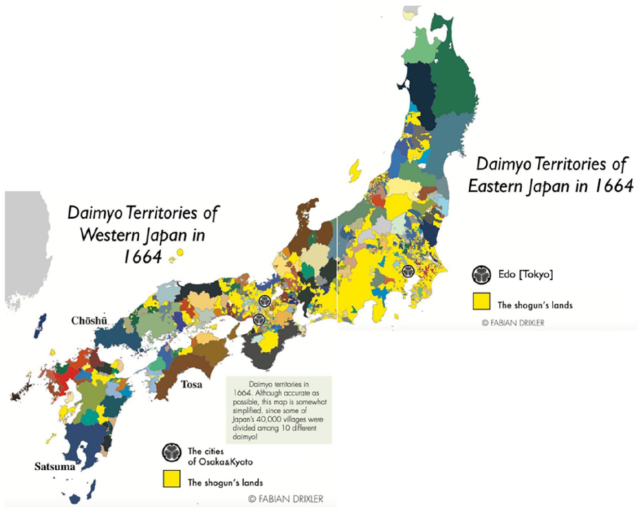
Map of territories in early modern Japan.
To avoid presentism, scholars must employ a “forward-looking strategy” (Tilly, 1992: 30) to make assessments of the contemporary situation during the early modern period. Domanial borders in early modern Japan may not seem to qualify as borders if one argues that they were “internal” borders. However, distinguishing between domestic and international borders while not acknowledging the sovereignty of early modern Japan is self-contradictory (Ringmar, 2012: 5). Because Japan as a whole did not qualify as a full sovereign state during the early modern period, one cannot impose a distinction between Japan’s internal and external borders. Early modern Japan must be treated more as an international system than a unitary state.
Students of Japanese history widely share this understanding of early modern Japan, but IR scholarship typically considers early modern Japan as one unit based on their modern understanding of Japan. 9 Setting the unit of analysis in historical studies based on modern understanding produces a “territorial trap” in IR scholarship. Although there have been some analyses of early modern Japan, students of IR have not conducted an empirical assessment of its territorial order, using both English and Japanese sources, the latter of which has been largely overlooked outside the country. Japanese historical scholarship, on the other hand, is not usually cognizant of the understanding of early modern Japan in IR and rarely discusses the case to find implications for IR theories. This article intends to fill both gaps.
Despite the Shogunate’s weak authority and significant autonomy of domains, the presence of the central power in Japan may make one believe that there was a structural difference between Japan and Europe in the early modern period if Europe was without such central authority. 10 This may lead one to expect different outcomes in border-making. However, a number of studies in the last few decades have demonstrated that the Peace of Westphalia did not mark the end of the universalist ambition of the Habsburgs and the establishment of the sovereignty of individual states within the empire (de Carvalho et al., 2011; Osiander, 2001; Teschke, 2003). In fact, there were important similarities between the governing structure in early modern Japan and the Holy Roman Empire in roughly the same period, if not Europe as a whole.
Even after Westphalia, the emperor remained to be the central authority within the Holy Roman Empire. It is true that individual estates of the empire were in charge of the actual governing within their realms, but their autonomy was limited by the laws of the empire, which did not change in 1648.
11
Osiander (2001: 271) maintains that the emperor continued to exert juridical control over the empire even after 1648 and was essentially a higher power who in some cases deposed individual rulers:
The emperor exercised direct jurisdiction only over his own dynastic lands, not over the subjects of other estates of the empire. Yet he retained a pivotal role in the politics of the empire even after 1648. He exercised considerable influence over the Reichstag. Motions he proposed carried particular weight, and the Habsburgs disposed of a considerable number of Reichstag votes. Conversely, the emperor could veto any decision of the Reichstag. He also retained certain other prerogatives, such as supreme command of the joint army that the estates of the empire would raise if the Reichstag decided it.
It is not difficult to find common features between the two systems; early modern Japan and the Holy Roman Empire can thus be seen as hybrid systems in which there was a weak central authority and largely autonomous states.
Importantly, when scholars discuss state formation and linearization of borders, they do not treat states within and outside the empire differently; they speak of the European sovereign state system as a whole, including both in the discussion. The current understanding is that the development of linear borders in states in imperial estates was no different from that outside the empire. This suggests that structural differences (i.e. the presence or absence of higher authority) did not necessarily engender differences in border demarcation. What was arguably more crucial was the mechanisms of boundary formation on the ground within those systems. As I show in the following section, the process of boundary-making in early modern Japan was similar to that in early modern Europe because the mechanisms (war-making and state-making followed by institutional development) were common to the two regions.
In the next section, I examine territorial order in early modern Japan, focusing on the development of territorial rule based on linear borders and mutual exclusion. It leads us closer to an apprehension of the reality of early modern Japanese territorial order, which has hardly been available in IR. I do not, however, intend to conduct a full-scale historical study of early modern Japan. This is essentially an IR study aiming at giving feedback to IR theories on a specific aspect of territory, rather than a history article intending to find new historical evidence.
Territorial order in early modern Japan
Origins of linear borders
With the decline of the central authority of the Ashikaga shogunate (1336–1573), Japan experienced severe fragmentation. This period, known as the Sengoku (戦国: warring states) period, lasted for more than a century from the late 15th century to the beginning of the 17th century. It witnessed the emergence of numerous warlords called the Sengoku daimyō, who exercised effective control of their domains while constantly fighting each other. Many of them succeeded in building states through warfare, just like their European counterparts, which seems to fit Tilly’s (1992) famous theory of war-making and state-making.
During the Sengoku period, warlords implemented state-making projects to mobilize resources necessary to fight their competitors, just like their counterparts in early modern Europe. They collected taxes, conducted land surveys, and developed standing armies. Historians of Sengoku Japan thus see the territories of the Sengoku daimyō virtually as sovereign states. Marushima (2013), for example, lists three reasons for his support of this view. First, the daimyō had their own legal system independent of the central authority within their domains, which made them the highest authority. Second, they used the word kokka or okuni, which means the state, to describe their territories. Third, Portuguese missionaries who visited Japan called the Sengoku daimyō the king, applying the same title as the Portuguese king.
Many of the battles fought between Sengoku warlords involved boundary demarcation (Marushima, 2013). In the period of anarchy without any higher authority to intervene and impose territorial arrangements, the daimyō inevitably had to establish their control over their realms with force. They fought each other to expand their territory or, on the contrary, defend it, and the war ended with the demarcation of new boundaries so that it becomes clear who controls which areas and there would be no further conflict. Batten (1999: 175) concisely summarizes the process of state formation and border delineation:
During the late fifteenth and sixteenth centuries these warlords, known as sengoku daimyō, consolidated their rule over domains that were essentially sovereign “mini-states.” . . . But in practical terms each sengoku daimyō was more or less independent of the others and of any higher authority. For that reason the boundaries between their domains can be treated as emergent “national borders.” These borders certainly shifted frequently because of the fluid political situation, but it also seems likely that they were relatively well-defined and were more like boundaries than frontiers. Sengoku daimyō were very active in surveying their territories in order to clarify land rights and tax obligations. This strong emphasis on control over territory, coupled with the high state of tension between adjoining warlords, would have led naturally to the emergence of fairly well-defined borders.
It can be said, therefore, that the origins of linear borders in Japan can be found in the war-making and state-making process during the Sengoku period, similar to early modern Europe or the Warring States period in ancient China (Hui, 2005) and possibly different from other cases such as Africa (Herbst, 2000). 12
However, the Sengoku period came to an end through the unification attempts led by three leaders—Oda Nobunaga, Toyotomi Hideyoshi, and Tokugawa Ieyasu. They defeated or made peace with the other warlords and gradually extended their rule over what they perceived to be Japan. Although the first two remained in power only briefly, Tokugawa Ieyasu succeeded in establishing a regime, the Tokugawa shogunate, that would last for more than two and a half centuries. Ieyasu received the title of shogun from the emperor, who had only nominal and ceremonial power, after he defeated his opponent Ishida Mitsunari in the Battle of Sekigahara in 1600.
This title, however, by no means meant that Ieyasu had full control of Japan. Despite his title, he was “in many ways still a regional warlord whose allies and erstwhile enemies alike enjoyed sovereign rights within their own domains” (Wigen, 2012: 56). In the next decades, he and his successors kept trying to consolidate the shogunate’s rule through various measures. 13 However, their unification efforts proved only partially successful. On the one hand, they succeeded in reducing the power of the daimyō to some extent through the system of sankin kōtai (参勤交代: alternate attendance duty). Under this system, the daimyō had to live alternately in the capital at Edo and in his own domain. It served as “a constant reminder of the primacy of the Tokugawa house” (Ravina, 1999: 17). The shoguns also confiscated the domains of some daimyō and replaced them with more loyal vassals.
On the other hand, they failed to erode the “sovereign” status of the most powerful daimyō called the kunimochi daimyō (国持大名)—domanial lords who autonomously controlled a large amount of land, often in peripheral regions, many of whom were former Sengoku warlords. They were often exempted from dismissal or transfer and treated more like sovereigns than vassals except in the very early Tokugawa period (Ravina, 1999: 21). There were varying degrees of autonomy and the shogunate’s influence within Edo Japan.
What happened to boundary-making after the establishment of the Tokugawa shogunate? In some parts of Japan, the incomplete process of the linearization of borders, or the transition from frontiers to boundaries, that began in the Sengoku period was brought to a halt and failed to develop further. For example, areas around Kyoto and Nara, known as Kinai, were under the control of dozens of different lords, including daimyō, the shogun, the imperial family, and religious organizations, which complicated the territorial arrangements and made it hard to demarcate borders clearly.
However, as Iwata (1953: 10: the author’s translation) maintained, border demarcation developed significantly in the realms of some powerful tozama daimyō (外様大名: outsider lords),
14
who became Tokugawa vassals after the Battle of Sekigahara, including former opponents or reluctant supporters of the Tokugawa clan:
If you examine borders between domains during the Edo period through disputes, you would notice that they were mostly linear boundaries. It was especially true for the borders of tozama yūhan. Frontiers were more or less reorganized soon after the beginning of the Edo period, which was often accompanied by boundary disputes. There were cases of boundary disputes between domains in the mid-Edo period as well, but they are mostly geographically limited; full-scale disputes had been completed before the Genroku era [1688-1704] at the latest. This means domain borders had already become frontiers of convergence by then and finished evolving into linear boundaries, which was particularly the case for tozama yūhan, which did not experience transfer or include enclaves. All contiguous tozama yūhan, without an exception, had large disputes with each other. Large disputes between Akita and Tsugaru, Nambu and Akita, Nambu and Tsugaru, and Nambu and Date mostly ended around the Kan’ei [1624-1645] and Kanbun [1661-73] eras, and therefore you cannot see common lands with ambiguous dominion around these borderlands.
In these domains, the daimyō further advanced the state-making process initiated in the Sengoku period, leading eventually to the demarcation of linear borders. Frontiers, which were zonal and fuzzy, became linear and clearly demarcated boundaries in the early modern period, much like in early modern Europe. The following subsections explain how this change materialized in Edo Japan.
Boundary disputes
Boundary-making was especially crucial when the borders were contested. It was not always naturally clear where boundaries between domains lay, and in those cases, domains often found it difficult to demarcate them. In some cases, the daimyō negotiated with each other and reached an agreement. In other cases, they failed to find a solution and accordingly filed a lawsuit. When they finally resolved the issue, they exchanged a map and built boundary markers to perpetuate the borderline. Boundary markers were often a product of such boundary disputes. As Iwata (1953: 72) noted, solving boundary disputes meant the establishment of linear borders.
Especially in the 17th century, there were numerous boundary disputes between domains, not limited to tozama yūhan. Many of them were well documented and have been a subject of much scholarly attention (Inaba, 2005; Iwata, 1953; Koga, 1973; Narumi, 2002; Omori, 1995; Sakata, 2011; Sugimoto, 1999). For example, disputes between the Hachinohe and Morioka domains, which were located at the northern end of the main island of Japan, began in 1669 when two contiguous villages in each domain had a conflict over the use of a river that had brought important revenues to the domains because of its rich aquatic resources. The domanial governments exchanged opinions and conducted local investigations, eventually agreeing to set boundaries 3 years later. This boundary agreement was accomplished through exchanging picture maps of the borders and building mounds, which the relevant actors thereafter maintained (Honda, 1998). Figure 2 provides an image of one such map. It depicts the Hachinohe domain’s territory, showing the location of linear borders, which are demarcated with dozens of mounds. Each mound is numbered and drawn as a black dot with an explanation of its exact location in the text.
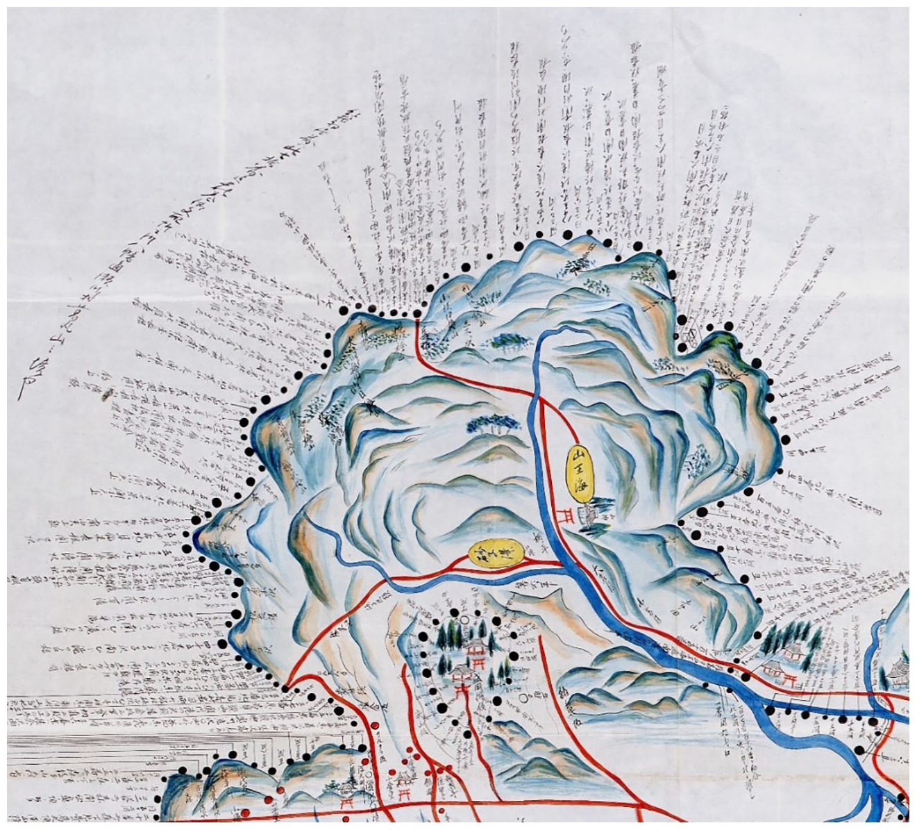
Map of borders between Hachinohe and Morioka.
The establishment of the border between Hachinohe and Morioka was an example of the out-of-court settlement of a boundary dispute, but not all disputes were resolved as peacefully. In many other cases, boundary disputes evolved into legal disputes. A good example is Ishima Island on the Seto Inland Sea in western Japan. The territorial attribution of this island had been contested between the Okayama domain and a shogunate’s territory based in Naoshima Island. The former argued that the northern half of the island was its territory, while the latter insisted that the entire island fell under its jurisdiction. This dispute initially began as an issue regarding the right to fish and collect plants on and around the island in the 1680s. Both parties tried to reach a resolution without resorting to legal measures, but repeated negotiations involving villagers and government officials proved unfruitful. Consequently, they brought a case before Hyōjōsho, the legal court of the shogunate, in 1689. 15
Hyōjōsho first ruled in favor of the Naoshima government in 1690, stating that the entire island belonged to it, but 12 years later, the Okayama domain gave it a second try. This time, the court changed its ruling in favor of Okayama and a linear boundary was finally set in the middle of the island dividing the territories of the two domains, as Figure 3 shows (Omori, 1995). After the Meiji Restoration, this border was passed on to newly created prefectures and it forms a border between Okayama and Kagawa prefectures even today. The same domains also contested the nearby Ōzuchi Island and the result was a similar solution; the island was divided into two territories, which later became a border between the modern Okayama and Kagawa prefectures. Boundary disputes and the linearization of borders were thus heavily intertwined with each other.
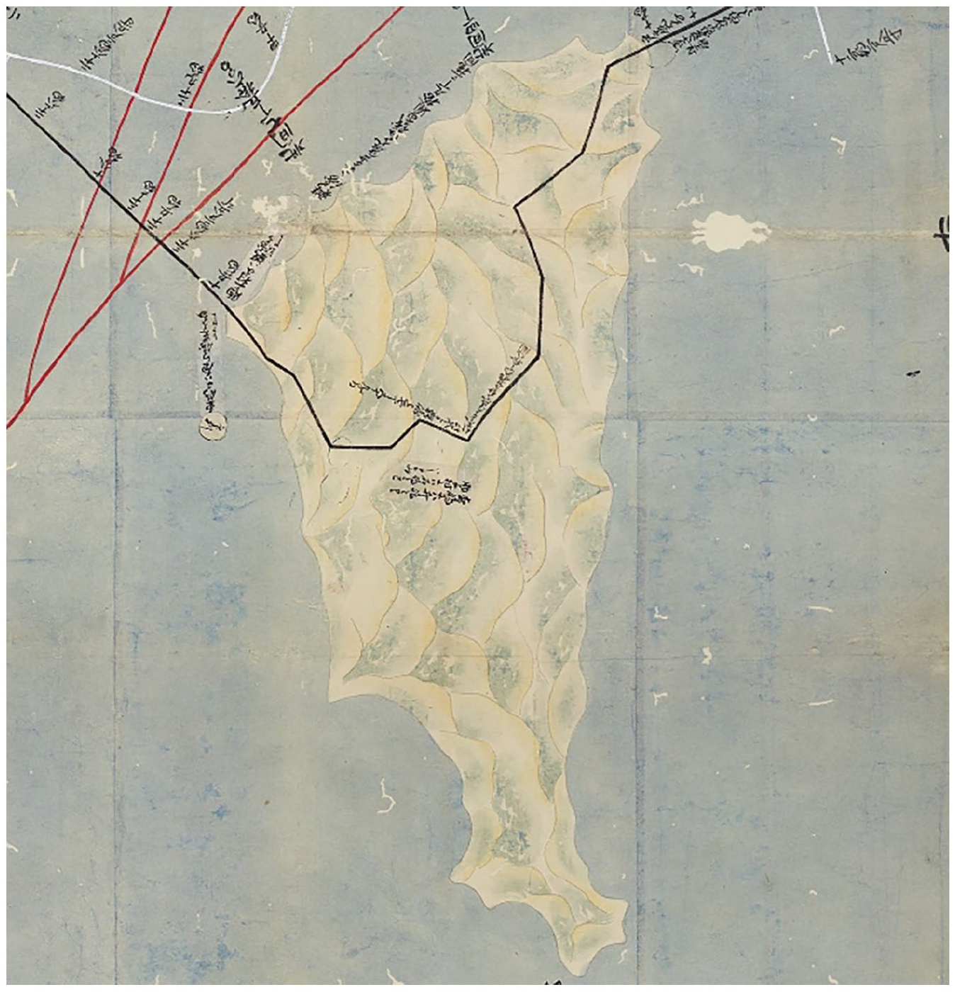
Map of borders on Ishima Island.
As in the cases of these islands, the increasing importance of border areas for economic activity or transportation was one of the triggers of boundary disputes. Iwata (1953) gave several examples, including the sea. In the medieval period, it tended to form a natural border zone as maritime transport was relatively minor. However, in the early modern period, maritime transport developed significantly in many regions, which nullified the sea’s role as a natural border zone and generated contests over which domain controlled it, creating the need to demarcate clear borderlines (Iwata, 1953: 105).
Rivers provide a similar example. Before river transport developed and the economic value of rivers increased, they were considered to separate areas naturally. There was no need to demarcate a borderline because the river itself was a frontier zone, which belonged to no one. However, as rivers became increasingly valuable, domains found it necessary to make clear where their territory ended, resulting in boundary disputes. This development occurred in both Europe and Japan (Iwata, 1953: 122–127). Other natural obstacles to people’s movement, such as forests, also lost their isolating functions with the development of the economy and transportation networks. Areas with unique economic value, such as gold and silver mines, were frequent sources of dispute as well (Iwata, 1953: 187). It is also important to point out that the demarcation of boundaries reduced ambiguities about the possession of particular properties. The amount of iriaichi (入会地: common land) in frontier areas straddling two domains declined significantly over time as domains defined their borders more clearly, terminating usufruct rights (Iwata, 1953: 70).
The delineation of boundaries was possible partly because of extensive land surveying in the Edo period. Because domains depended on land taxes rather than capitation as their primary source of revenue, assessing the value of the land was crucial. Although there were often significant errors in the measurements and peasants who feared an increase in taxes sometimes resisted, the development of land surveys in early modern Japan facilitated the process of border demarcation between villages and domains (Brown, 1987: 121).
These examples of boundary making in early modern Japan are in accordance with the institutionalist theories of international borders (Carter and Goemans, 2011; Goemans and Schultz, 2017; Simmons, 2005). That is, borders served as international institutions that “help to secure property rights, signal much greater jurisdictional and policy certainty, and thereby reduce the transactions costs associated with international economic transactions” (Simmons, 2005: 823). Considering that there were nearly no direct militarized conflicts between domains during the Edo period, the function of borders was arguably more institutional than military. Many borders in early modern Japan were drawn as a result of increasing economic activity or the pressing need to determine, for example, who can fish in a given sea, levy taxes on a given land, or make use of a given river. In other words, domains sought to “coordinate the expectations and behavior of both international and domestic actors and thereby produce joint gains” (Carter and Goemans, 2011: 282). By agreeing on borders and exchanging maps, domains managed to avoid further escalation of disputes and enjoy the benefits of stability.
Interestingly, this suggests that the function of borders in the early modern period was different from that of those in the Sengoku period, when boundaries were arguably born out of constant militarized conflicts. Although testing this idea is beyond the scope of this article, it is possible that this change reflects a shift from a war-driven state formation process (Tilly, 1992) to an economy-driven one (Spruyt, 1994). While border-making in Sengoku period can be explained mainly by war-making, that in the Edo period arguably owes more to the establishment of borders as international institutions. During the Sengoku period, there was always the possibility of further military conquest, which would be accompanied by changes in borders. In other words, the daimyō did not necessarily have enough incentive to perpetuate borders; boundaries at a given moment were well defined, but they could change in the future when conflicts occur. With the prohibition of inter-domanial conflict and territorial expansion imposed by the shogunate, however, military conquest was no longer an option in the Edo period. It became impossible for the daimyō to forcefully change borders. This relative fixity of territoriality arguably changed the perception of domains in favor of drawing, consolidating, and perpetuating linear borders for institutional stability and the maximization of economic benefits rather than waiting for future expansion. 16
Boundaries and mutual exclusion
What did these demarcated borders look like on the ground? First, it was common for the daimyō to construct boundary markers to clarify where their realms began and ended. Boundary markers took diverse forms, including stones, mounds, and trees, sometimes mixed with each other. In some cases, it was just one stone showing the edge of the territory, but when the borders were contested, setting only one boundary stone was insufficient. Disputed boundaries required more precision. In these cases, domains usually built multiple markers along the borderline.
For example, the Morioka domain in northern Japan, whose lord was a kunimochi tozama daimyō, was particularly committed to building boundary markers. It was among the first to set boundaries with its neighbors, including the Akita and Hachinohe domains (Honda, 1998: 55). One of the most notable examples is its boundaries with the Sendai domain. After more than 50 years of repeated boundary disputes, Morioka and Sendai finally succeeded in demarcating borders and agreed in 1642 to construct more than 100 mounds along 130 km of borderline to prevent any future confusion (Ikeda, 1975: 259). These mounds were large and sparse at the beginning, but they became smaller and more densely spaced as time passed, which illustrates the process of transition from zonal frontiers to linear boundaries (Iwata, 1953: 54).
Because of the durability of the material, more stones than mounds survive today. Figure 4 shows boundary stones placed between the Kurume and Yanagawa domains. 17 Figure 5 pictures boundary mounds built along the border between the Morioka and Hirosaki domains.
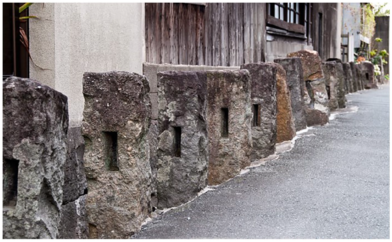
Boundary stones between Kurume and Yanagawa.
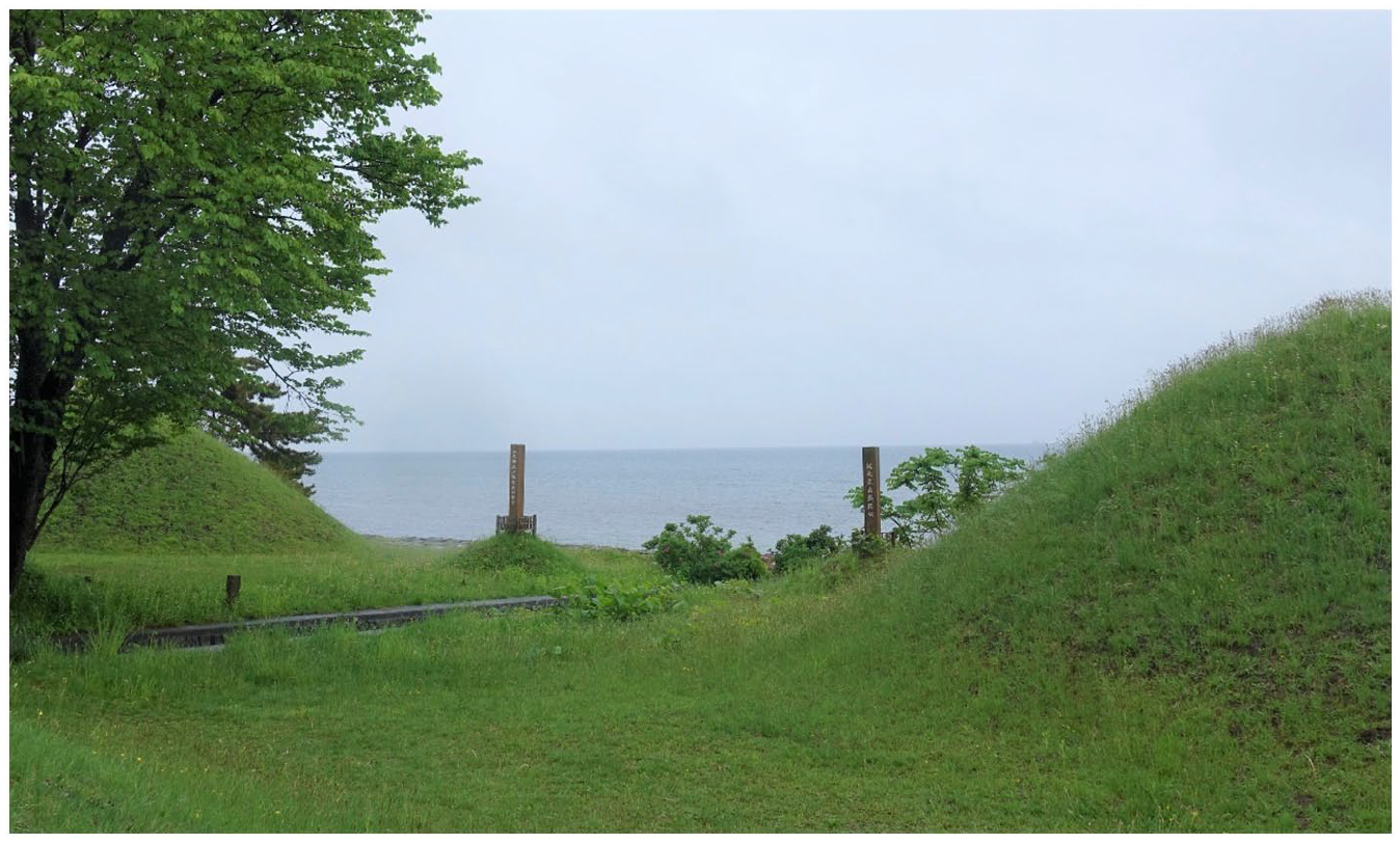
Boundary mounds between Morioka and Hirosaki.
Domanial governments not only demarcated borders with these markers but also policed them. They built guardhouses on both sides of the borders and stationed soldiers to control the entry of people and goods. The Aisari village of the Sendai domain, which was located near the border with the Morioka domain, provides an example. In this village in 1656, the government introduced a guardhouse with 102 soldiers (Sugiura, 1991: 419). By monitoring transportation and communication across the border, the soldiers maintained the security of the Sendai domain’s territory.
Although the mere presence of linear boundaries does not necessarily indicate territorial rule within those borders, there was also mutual exclusion across borders in early modern Japan. Different domains that were strictly separated by these boundaries also operated under distinct systems of rule without overlapping with each other. One example is currency. Although the shogunate issued gold and silver currencies that could be used across domains, many, though not all, domains also issued their own currency (Nakano, 1984). The central government tried to regulate and sometimes ban currencies other than its own, but it eventually changed its policy and permitted the practice, which is another example of the limits of centralization (Murata, 2003). What is important in the current discussion is that these currencies could be used only inside the domain; they were worthless outside the territory of the domain that issued them because the currency system of each domain was independent.
Second, domains, especially the powerful tozama yūhan, maintained their own jurisdiction in most respects. If a criminal escaped from one domain into another, the former could not enter the latter’s territory to make an arrest. Similarly, if peasants abandoned their lands and fled to another territory to avoid heavy taxes, domains had to negotiate with each other to arrange their return rather than entering other domains to bring them back (Kimura, 1997: 255). Yamada (2018) concluded that kunimochi daimyō had their own autonomous legal system that was largely equivalent to the system applied in shogunate’s territories, although they were still formally subject to orders of the shogunate to adopt a law.
Third, domains often prohibited intermarriages with people in other domains. In an extreme case, intermarriage was prohibited among residents of two villages that were just 300 m apart on different sides of the border (Ikeda, 1975: 272). In those cases, borders meant strict mutual exclusion. In the case of Aisari and Oniyanagi villages that belonged to Sendai and Morioka domains, respectively, mutual exclusion was so strict that although those two adjacent districts are now part of the same city in the same prefecture, they still have different cultures, communities, and identities and show unwillingness to integrate even nearly 150 years after the abolition of domains (Sugiura, 1991). 18 These examples demonstrate the presence of mutual exclusion in early modern Japan.
The influence of map-making projects
Map-making projects also facilitated the process of border demarcation. In medieval Japan, most maps represented private landholdings. There are no maps of districts, provinces, ports, or administrative headquarters extant today (Berry, 2006: 56). This nearly map-less society transformed dramatically into one with exceptionally rich and diverse maps with the development of printing technology in the early modern period (Sugimoto, 1999: 160).
Among the different types of maps, the most important for territorial rule were what were called kuniezu (国絵図: country maps). The shogunate was in charge of the creation of the maps, but it was domanial lords who provided individual maps for the shogunate to compile. The first map-making project began in 1604, just 1 year after the establishment of the shogunate. During the Edo period, the shogunate ordered the creation of kuniezu five times—1605, circa 1633, 1644, 1697, and 1835 (Yonemoto, 2003: 9).
An important fact about kuniezu is that their basic units were provinces, not domains. In ancient times, Japan was divided into 66 provinces, which were subdivided into districts. This imperial administrative system disappeared from the rule on the ground with the reshuffle of the existing order and the decline of imperial power during the Medieval period and the Sengoku period but survived as a concept well into the Edo period. Although in reality, politics in early modern Japan was organized by domains, and provinces did not serve as administrative units, the shogunate still insisted on using the latter as the units of kuniezu. There is a debate on the reason for this choice, but one plausible explanation is the shogunate’s desire to detach the land from the local daimyō and emphasize that Japan was unified under one ruler (Berry, 2006: 87; Yonemoto, 2003: 13).
This approach proved partially successful. Although there was initially significant inconsistency in the format of the map, and some maps included an indication of domains, the kuniezu created in the Genroku era (1688–1704) marked a clear departure from previous maps. The shogunate successfully imposed the same format on all mapmakers across Japan and completely erased domains from the maps. The consolidation of shogunal power made this consistency possible (Kawamura, 2009: 115–125).
However, the making of provincial maps also had a by-product; it encouraged boundary disputes between domains and led to the consolidation of linear borders. The process of map-making was complex. First, the shogunate appointed one daimyō or shogunal vassal per province to be responsible for making the map of the province (Kawamura, 1996: 24–28). In many cases, the boundaries of provinces did not correspond with those of domains, which sometimes included multiple provinces. In other cases, such as regions around imperial and shogunal capitals, there were numerous domains within a single province. Therefore, not all daimyō were in charge, but even if they were not, they still had to cooperate with the one in charge to put their territory on the map. It was a two-stage process; first, each daimyō created a map of his domain and submitted it to the daimyō in charge of creating a map of their province, and then the one in charge compiled the individual maps and submitted a map of the entire province to the shogunate (Kawamura, 1996: 85–86).
In this process of creating a provincial map, numerous cases of boundary disputes between domains occurred. Making maps of domains as well as those of provinces necessitated the demarcation of borders between domains and provinces, but the boundaries were not necessarily clear. Kawamura (1996: 88–89) identified several examples of this sort, including disputes between the Yonezawa and Soma domains regarding a mountain, the Okayama and Marugame domains over islands, and the Aizu and Takada domains regarding a silver mine. All of these disputes stemmed from the map-making process.
As a response to the rapid increase in boundary disputes, the shogunate issued a guideline for the demarcation of borders when it ordered the making of provincial maps in the Genroku era. There were five points regarding the process of demarcation (Kawamura, 2009: 108–109):
Confirm the borders by matching maps of them created by each party.
Add a description of borders on the final map in text.
Depict borders unambiguously on the final map.
If the mountain that constitutes a border is called differently between the two parties, add both names on the final map.
Exchange a deed of agreement on borders.
Although the degree of the linearization of borders differed among provinces, higher in the periphery than in the center, this practice enhanced the boundary-making process.
The case of early modern Japan thus partly confirms the thesis that map-making affected boundary-making (Branch, 2014; Strandsbjerg, 2010), but it also presents a different picture in an important way. On the one hand, domains made increasing efforts to demarcate their borders, linearize them, though to varying degrees, and make a clear distinction between different territories through participation in the shogunate’s map-making projects. On the other hand, however, although the maps used provinces, not domains, as their basic constituent units, this framework did not affect the actual governance structures. Domains, not provinces, remained the central unit of rule throughout the Edo period despite the efforts of the shogunate to create maps that viewed Japan as a unitary state divided into provinces. This particular point seems to differ from existing explanations about how cartography has affected political order (in Europe) and suggests the weak authority of the shogunate over domains and the strong autonomy of the latter. In any case, the map-making process advanced the boundary-making process in early modern Japan, indicating the presence of similar developments in Europe and Japan.
European influence?
Through the above discussion, we have established that early modern Japanese domains were already well into the process of establishing a territorial rule based on linear borders. The complete consolidation of this territorial rule, as well as Japan’s entry into international society, did not occur until the Meiji era, but I have shown that the Meiji Restoration around 1868 did not mark as drastic and comprehensive a change in this area as previously assumed. As some historians of Japan have suggested (Sugimoto, 1999: 162; Wigen, 2012: 121–125), the transition from non-territorial rule to territorial rule, or put differently, from frontiers to boundaries, developed significantly in the early modern period, not just after the Restoration. This development is similar to and chronologically overlaps with what happened in Europe (Iwata, 1953: 52), making it a parallel development. Therefore, the conventional assumption that non-European polities did not have the traits of the sovereign state before European expansion does not hold in the case of Japan.
Is it still possible that the developments in early modern Japan were in reality an outcome of its interactions with Europeans? Similar to Branch’s (2012) story of colonial reflection, was it Europeans who established linear borders in Japan, not the Japanese themselves? It is the case that there were limited interactions with Europeans in early modern Japan. The Dutch, who were the only Europeans to whom Japan officially allowed entry, brought various goods and cultural practices to Japan, including European scientific knowledge. European culture also came through the Chinese and Koreans. This included some mapping technologies that were later applied to maps in Japan. For example, Nagakubo Sekisui, who had obtained some knowledge of European cartography, made the first known use of coordinates and longitude-latitude grids in Japan in the 1770s, although his maps were not domanial maps (Yonemoto, 2003: 35–39).
However, while Japan began importing and learning European science systematically in the late 18th or early 19th century, its development of linear borders occurred most intensively in the 17th century. During the early modern period, Japan prohibited foreigners from entering, except for a few places, and never employed foreigners as advisers, as it did later in the Meiji period. Therefore, no evidence suggests the contribution of Europeans to the development of linear borders in early modern Japan.
Even in the process of learning European science from the late 18th century, the Japanese mostly acquired new knowledge from writings and applied and developed the knowledge on their own. This is not dissimilar to the “discovery” of Ptolemaic technologies of mapping through Arabic texts and subsequent development in map-making in Europe (Branch, 2014). It is, therefore, problematic to dismiss the former as unoriginal while recognizing the latter as a European original development. In addition, Europe itself was still at an early stage of the long process of establishing territorial sovereignty in the 17th century. Therefore, even if there was limited European influence, the developments in Japan could not have been a mere importation of European territorial sovereignty, as Europe itself had not established it yet. These points suggest that the development of territorial rule based on linear borders in Europe and Japan represented parallel processes, not a case of the latter’s emulation of the former.
Conclusion
The study of the history of the sovereign state constitutes the foundation of the modern understanding of international orders. Without knowledge of how the current order developed, it is impossible to accurately evaluate the current situation or make predictions. However, scholars have devoted scant attention to the history of non-European international orders. Although there have been recent revisions, the conventional understanding that non-European polities did not have elements that constituted a territorial state before the arrival of European influences remains prevalent.
This article challenges this assumption and demonstrates that what was thought to apply only to Europe also applies in a non-European context. It identifies similarities between the Japanese early modern territorial order and its European counterpart, suggesting that the development of linear borders occurred in parallel processes. The daimyō, especially former warlords in the periphery, tried to demarcate boundaries with their neighbors and built boundary markers to perpetuate them. They policed the borders, and the political, economic, and social life in each domain was separated from its neighbors by borders without overlap. Boundary disputes frequently occurred in the 17th century between domains and led to the construction of markers. Map-making projects by the shogunate brought these boundary disputes to the fore and facilitated territorial demarcation. All of these developments were not universal across Japan and some areas remained much less territorial than others, but there is no doubt that linear borders were not foreign to early modern Japan.
This article makes three contributions to the scholarship. First, together with recent studies on the timing of the consolidation of the sovereign international order, this study contributes to the revision of our understanding of the history of territorial sovereignty. In contrast to studies on the timing of the consolidation of the system in Europe (Osiander, 2001; Teschke, 2003), this article has focused on the geographical aspects of the “Westphalian myth.” The linearization of borders did not simply occur in Europe and then in non-European areas of the world; at least in the Japanese case, it was a parallel development that occurred simultaneously with its European counterpart. This suggests that non-European actors had much more agency in the development of linear borders than has been commonly understood. This study updates the understanding of territorial order outside Europe and advances knowledge of international orders in history.
Second, this article has implications for non-Western or global IR scholarship. Although most existing studies of non-Western international systems focus on differences with Europe, emphasizing the inapplicability of existing theories, this article highlights similarities. By doing so, it questions the uniqueness of the European sovereign state system and suggests that focusing on similarities can be an alternative way to address the issue of Eurocentrism in IR.
Third, this article suggests that Japan’s exceptional success in its adaptation to the European sovereign state system during the Meiji period can be attributed not only to its rapid acceptance of European norms or the logic of imperialism (Suzuki, 2005) but also to preexisting factors that originated in the early modern period. Although an examination of changes after the Restoration is beyond the scope of this article, it is possible, for example, that Japan’s familiarity with the concepts of linear borders and territorial rule, which had already existed in Japanese society since the Edo period, facilitated its early adaptation to the new world order in the Meiji period. After Japan overcame long-standing fragmentation and became a fully unitary state, it ceased to be an international system. However, it may have applied the experience of border demarcation between domains to boundaries among sovereign states, the new constituent units of the emerging international system. Future research may benefit from further investigation of continuity in territorial practice before and after the Restoration.
Although linear borders are an essential element of the sovereign state, they are only one aspect. Future research should also investigate other factors commonly linked to the modern state. Some scholars have already begun working toward this goal. Ichijo (2020), for example, focused on the rise of nationalism and argued that kokugaku during the Edo period, rather than Westernization in the Meiji era, marks the beginning of Japanese nationalism. More research on the conceptual, legal, and financial aspects, among others, of the sovereign state would advance a broader understanding of the expansion of the sovereign state system. Similarly, it is also important to examine whether the argument put forward in this article applies to other non-European cases. Did a similar development of linear borders occur in the Ottoman Empire, China, India, or pre-colonial Africa? Studying more cases would yield a better understanding of territorial sovereignty in non-Western international systems.
Footnotes
Acknowledgements
A previous version of this article was presented at the annual meeting of the International Studies Association (March 2021, online) and the Seminar in the History of International Politics (SHIP) at the University of Oxford. I am grateful to Martin Bayly, Fabian Drixler, Kerry Goettlich, Jaakko Heiskanen, Iver Neumann, Shin Sato, Ameya Pratap Singh, Fumiko Sugimoto, Takahiro Yamamoto, and two anonymous reviewers for their excellent feedback on early drafts of this article.
Funding
The author(s) disclosed receipt of the following financial support for the research, authorship, and/or publication of this article: I would like to thank the Sasakawa Fund for research funding.