
Abstract
As a key component of decarbonisation, many nations are undergoing an energy transition from fossil fuels to solar, wind, and other renewable energies. This is creating landscape transformations in ways prior energy regimes did not. Scholars, environmentalists, and Indigenous people are calling attention to how the renewable energy economy impacts the environment. This article reveals the findings of a practice-led project involving the production of drone-based images and the generation of scaled computer visualisations to present aerial views of existing, under-construction and proposed renewable energy industries on Indigenous lands in Australia and the United States. Research outcomes are an initial step in conceptualising energy justice and understanding what is being created and lost during the energy transition. More broadly, this research contributes to a theory of the politics of perception and how seeing is relative to technological perspective, energy regimes, and historical context.
Introduction
The size of the human body is between an electron and the universe. Apocryphal or not, this framing of relational magnitudes, from the quantum to the cosmic, situates all known living beings in our proper context somewhere between Earth and heaven. The seat of the senses and thus the source of all relativity, it seems appropriate that the human body be “the measure of all things,” to paraphrase Protagoras. Such anthropocentric thinking, however, has been abjured by what astronomer Carl Sagan (1994) called human's “Great Demotion” from being the centre of the universe and created by God to inhabiting a rather anodyne galaxy and evolving from single-cell organisms. Thus from Copernicus to Darwin, Marx's argument for the conflictual nature of history, and Freud's thoughts on our basal instincts, humans have been on a steep regression to the status of a beast. With these demotions no longer were humans situated near the Almighty atop the scala naturae or the Great Chain of Being at the pinnacle of complexity with plants, animals, and minerals far below. Drawing from Aristotle's biological investigations and inspiring Linneaus’ ordering of species, the scala naturae preserves a spatial way of relating values, order, and scale (Figure 1).

Rhetorica Christian by Didacus Valedase (1579). Source: Wikicommons.
One need not be a quantum physicist, cosmologist, or mediaeval sophist to experience the maelstrom of scales in the present. Colonialism and other globalizations challenged the idea of proximity by collapsing relations. Beginning with the maritime colonies of the fifteenth century BC Phoenicians in the Mediterranean Sea and the seventeenth century Dutch in the Pacific Ocean, the far away—and their valuable goods and malicious gods, guns, germs, and steel—came near. One teleology of the history of conquest and communication is this collapse of vast space into governable units manageable by bureaucrats, surveyors, capitalists, and eventually computers. This has meant a coarse-grained reduction of complexity into symbols and systems that are portable, manageable, and relatable to the human body and its senses. As normative human bodies and minds expand through networks and knowledge, distance and immensity are no longer so, becoming proximal and small through habituation.
As Indigenous people or the precolonial inhabitants of Australia and North America understand, this compression of spacetime is not without its consequences. It requires energy. Each energy developed, from the chemistry of metabolism, to the wind thrusting the sails of exploration, and the fire at the hearth of today's carbon economy has a contradiction at its core that can be observed. That paradox is the greater the compression of spacetime here, the larger the void made in spacetime there. To make relatable to the human body the biggest and smallest phenomena, the expansion of the universe with the Big Bang or the quantum dynamics of the Higgs-Boson particle, requires the intensification of energy–energy that was pooled and extracted from somewhere–usually from land taken from somebody. This article is a reminder of this paradox.
Catalysed by James Watt's steam engine in 1784, the industrial revolution and its continuance to the present day were enabled by harnessing the concentrated energy currents contained within fossil fuels. Building complex logistical webs and life processes around these energy sources has become problematic chiefly due to their emission of greenhouse gases. One result is a contribution to the Anthropocene, the proposed epoch defined by human impact on Earth's geology (Crutzen and Stoermer, 2000). The signature artefacts of the fossil fuel industry such as oil derricks, coal surface mines, power plants, and gas pipelines (Figure 2) now exist alongside and in some contexts are being replaced by large-scale solar and wind farms and green hydrogen development hubs—heralding a shift to renewable energies. The mining of critical minerals (e.g., lithium for batteries, iron ore for wind turbines, bauxite for aluminium photovoltaic (PV) framing, sand and quartzite for silicon in photovoltaic panels) to construct these infrastructures also contributes to the corrosive effects of energy transition on the landscape. Scholars, environmentalists, and Indigenous people are organising to call attention to how the renewable energy industries impact undeveloped lands (Temper et al., 2020). Energy transition is underway (Bogdanov et al., 2021) and the relationship between seeing and understanding the impacts of the renewable energy industry on the landscape is under theorised. At this early stage in the energy transition, it is necessary to critically visualise energy transition so as to better understand the scale of its consequences and how it aligns with previous extractive practices like colonialism and global capitalism. With a critical visuality of scale, we can better understand what is being created and lost during this energy transition.
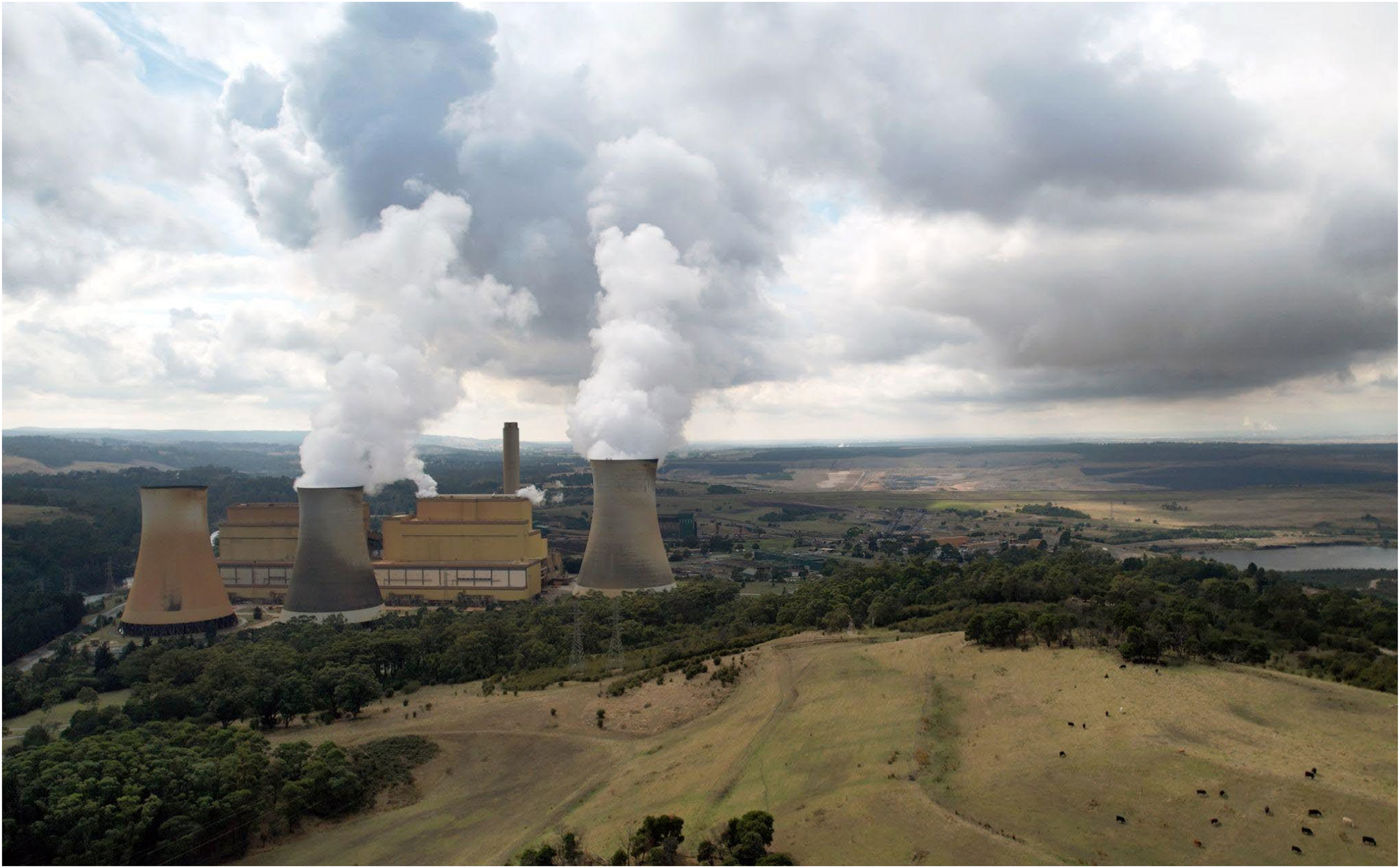
Cattle graze on fill mounds next to yallourn power station and open-cut coal mine in the latrobe valley in Victoria, Australia. The coal fired power station provides around 8% of Australia's total electricity grid and is scheduled to close in 2028. Drone image by Zeunert.
Collecting energy from the sun and wind to substitute fossil-energy generation requires enormous expanses of land. Planned renewable energy projects in Western Australia (WA) are some of the biggest infrastructural projects yet designed in human history. For instance, the Asian Renewable Energy Hub is 6500 square kilometres in the East Pilbara region on the lands of the Nyangumarta people, while the Western Green Energy Hub is over twice that size in the state's south-east on the lands of the Mirning peoples. The environmental and social impacts of megaprojects of this vast scale–projects capable of producing gigawatts of electricity capable of powering a city– are little understood but if developed will be significant (Blanco et al., 2023). Democratising the seeing of megaprojects is an initial step towards transparency and initiating an open discussion about how best to balance environmental impacts with carbon emissions mitigation. This practice-led endeavour is an initial foray into image generation and speculating the potentials of scalar comparison.
Large-scale renewable energy projects are economically risky and ethically-challenging. They suffer from too many stakeholders, cost overruns, capital risks, concentration of wealth, political corruption, inflated expectations, biassed projections, authoritarian rule, environmental destruction, community opposition and social inequity (Yenneti et al., 2016). There is a valid concern that the market potentials and the location of renewable resources on Indigenous governed land will provoke a “green land grab”–a neocolonial appropriation of land from Indigenous people under the aegis of development (Corson et al., 2013). The lands of First Nations will be the target for deleterious sacrifice as in the earlier agricultural, industrial, and energy transformations that resulted in large-scale coal, gas, and mineral extraction—but in emergent and unfolding ways. To avoid cost overruns, legal hurdles, and ethical quandaries associated with developing renewable energy megaprojects some argue that First Nations could be included in planning and provided the opportunity for co-governance (Hunt et al., 2021). To inform this process of co-governance, this paper advances visual methods and produces visual documents of sites of renewable energy industrialisation. Visual methodologies must be innovated so that megascale renewable energy projects ultimately equating to greenhouse gas mitigation can progress based on informed prior consent by Native Title holders and other stakeholders.
Ranging across flying, floating, and suspended visual technologies, a plethora of new visual perspectives to aid in seeing the renewable energy transition are available. The vertical visions of the twentieth century provided by satellites, aeroplanes, and balloons, are now augmented by technologies like unpersonned aerial vehicles (UAV) or drones. It is not just drone photography, however, as computational systems of visualising are also providing novel perspectives on landscapes. Google Earth and off-the-shelf orthomosaic software that aggregate high resolution images into scaled representational drawings now provide scholars, artists, and developers with new ways of producing their work.
Seeing the scale of energy infrastructure with drones and computer models is an invitation to consider “energy ethics” or the costs, benefits, and alternative futures which energy transitions afford (Smith and High, 2017). Visually relating to the size of this energy development could encourage a rumination on the “social innovations” that emerge with energy transitions that have impacts on space, ecologies, and Indigenous territories (Evans and Phelan, 2016, McCauley and Heffron, 2018). Indeed, new visions, energy systems, and conceptualizations of justice appear together (Mitchell, 2011). Energy justice, thus, is a prominent concept with which to advocate for preemptively visualizing social innovations tied to energy transitions.
For those whose rights associated with energy through historical and cultural connections were previously underacknowledged, novel energy production and transmission is an opportunity to galvanise support for energy justice. Energy justice may manifest as “procedural justice” or a democratisation in decision making; “justice of recognition” or identification of the consequences of energy development; and “distributional justice” or the equal allocation of energy benefits (Sovacool & Dworkin, 2015). An Indigenous framing of energy justice is grounded in “energy decolonization” (Burke et al., 2018; Lennon, 2017) which functions as a “restorative justice” (Kanger and Sovacool, 2022) revising past omissions of rights associated with colonialism. Drone and computer visions of the socio-spatial realities of renewable energy infrastructure can prefigure policy discussions leading to “energy decolonization” (Burke et al., 2018). In particular, by making visible the problems and potentials of energy development, seeing scale emboldens the energy decolonization of recognition.
In this article, we combine and compare computer visualisations and drone images we collected from fieldwork at renewable energy infrastructure sites in Indigenous Australia and the United States, exhibiting how political issues are both buried and revealed in aerial pictorial representations. In our research as artist scholars and drone pilots we are motivated to better understand what politics can transpire from seeing industrial areas at scale asking: does seeing lead to knowing and knowing to action?
The drone, land art, and industrial seeing
Like computerised geographies, the drone's elevated mobility enhances documentation of the world below. The drone is an extension of human senses and mobility (Kapp, 1877; Leroi-Gourhan, 1964). It is often theorised as a tool for the exploration of vertical space, three-dimensional volumes, and the atmosphere or the water as elements (Fish, 2024). Less expensive, technically-challenging, and dangerous than flying helicopters and planes, the drone offers a relative democratisation or opening up for multiple economic classes vertical and volumetric views (Jackman and Squire, 2021; McCormack, 2016). Providing the ability to perceive from multiple angles and to overcome human's terrestrial-centrism as surface-bound creatures, the drone has been embraced by a range of industries, sciences, and art practices. Adding multispectral cameras and AI-supported computer vision, drones provide modes of perception that includes and transcends normative human seeing (Augostinho et al., 2020). The applications of drone seeing are vast and increasing—warfare, automated shark identification, monitoring of water pollution, the surveillance of protestors, and the delivering of humanitarian aid are examples of how the democratisation of vertical, volumetric, and elemental space has galvanised new ways of perceiving and acting (author).
The linkages between seeing and controlling have long been understood—science, agriculture, engineering, and many of the fundamentals of modern Western civilization depend upon enhanced perception (Cosgrove, 1998). With seeing often being a prerequisite for control, aspiration persists in linking vision to population domination and resource extraction (Lyon, 1994). Industrial control over environments through visual regimes and computer vision has been recently examined (Kaplan 2019, Rettberg 2023). The drone's application as a weapon of war has contributed much to connecting the technology to surveillance, assassination, and other acts that control biopower and even ontopower–the capacity for becoming an autonomous being (Richardson, 2024). But the same tools that provide this power to kill can also furnish the power to create—protect life, inform sustainable energy infrastructure, and generate art (Pong, 2022).
While the most prominent applications of drone vision have been for military use, photography, surveillance, humanitarian, and conservation applications, the use of drones in land art practice as well as industrial surveys are intriguing for understanding the relationship between seeing from above and landscape transformation. These two applications appear at first as unrelated. Land art is the production of aesthetic and experiential installations outside of the gallery. Often using organic materials–wood and stone, as well as more raw industrial materials like iron, steel, glass, and concrete–land art features manipulation of the Earth, its topography, soils, and geology. Land artwork can be large and its appreciation may require viewing from multiple angles, including those vertical and mobile. Robert Smithson's classic Spiral Jetty (1970), a circular sculpture of stone on the shores of the Great Salt Lake in Utah, United States, can be experienced by walking the path it makes or seeing it from the air. Before consumer drones, seeing such a view as a mediated but immediate experience would have required a helicopter, an aeroplane, or a contraption involving a balloon and a camera, otherwise pictorial representations would have been the only way of perceiving the Spiral Jetty. Many Spiral Jetty drone videos populate YouTube as testament to the democratisation of drone vision of land art (Figure 3). While land art is on a significantly smaller scale and features distinct aspirations towards a sublime commentary on the relationship between humans and the Earth itself, the process of seeing land art with a drone, is not unlike the practice of using a drone to document large scale industrial works (Fish and Richardson, 2022).
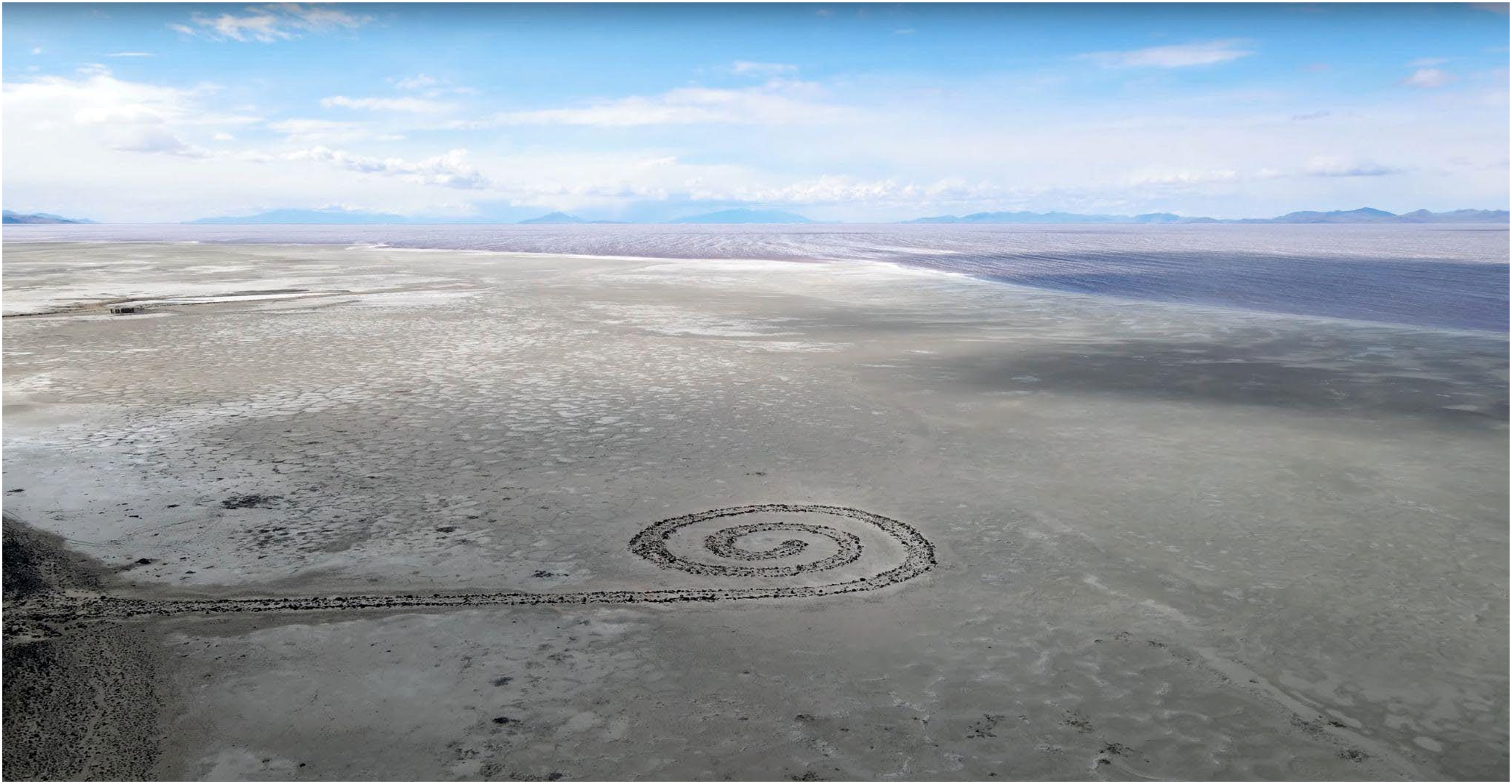
Robert Smithson's spiral jetty (1970) via screenshot from 2022 drone video by ‘mountains’ end’, YouTube.
Land art, like mining and renewable energy development, is also a concatenation of seeing and making. All are physical and tedious forms of labour; leave land-based artefacts, reflectively in the case of land art, or inadvertently in the case of energy industries. All require a legal right to land manipulation and thus an alienation of that land from someone else, usually Indigenous and rural people. All offer purposeful or accidental comments on materiality and how time corrodes it. Importantly, land art and energy industries are interdependent with technologies of vision. As drone piloting and computer vision artists documenting energy infrastructures, our project sits at the interface between these two practices (Stubblefield, 2020). As such, we offer an experiential understanding of what the drone and computer vision can and cannot see. In the process, we reveal what the aspirations for seeing energy reveal: the limits of seeing at scale and an invitation to consider the environmental and social consequences of industrialization.
What the drone offers that sessile terrestrial surveillance does not, nor satellite images, is the meso view—the view from the middle. Between the micro and the macro, the drone flies, inexpensively, safely, and with less need for human technical interventions. This meso view has more resolution than satellites and more context than ground cameras. The democratisation of meso vision invites new ideals of understanding, and indeed, control, over those artistic and industrial labours occurring below (Fish and Gomez Cruz, 2024). While the drone's meso-optimised view is insightful, it also presents limitations. Firstly, it can only see what is superficially present—it cannot see underground nor an energy industrialist's mental vision for a renewable energy megaproject. Secondly, drone camera lenses cannot encompass the full physical extents of megaprojects in a single image, and scale distortion can make size difficult to gauge, despite 360-image and panoramic mode capabilities. Accordingly, in order to perceive and better understand large renewable energy projects, computer visualisations can form a critical way of seeing. This project builds upon this assumption by positioning the viewpoint in the atmosphere and from the computer generated image.
Seeing with computer visuals
This paper is both informed by, and explores, what we term ‘scalar seeing’. We develop theories and practices of visual sociology attending to the multidimensional and scalar, from the meso to the macro. For improved comprehension of large sites such as renewable energy megaprojects, computer visualisations beyond the human terrestrially-ocular perspective or the drone's meso view must necessarily grapple with scale ratios which enable calibration and extrapolation between spacetime dimensions (Clark, 2012). Scaled representational drawings contribute to scalar literacy in renewable energy megaprojects. First observed in the realistic Palaeolithic pictography found in the European caves of Altamira and Lascaux and in early cartography which make relative depictions of geographies and territories, scaled drawing are now essential in engineering planning and are useful for revealing the scale of megaprojects. To set the scene for scaled computer visualisations, we composed a computer image in Figure 4 to convey perception gaps between ground level (human scale), meso aerial (drone), and macro (satellite) imagery. As our work shows, additional interventions in the form of graphics and other comparisons are needed to more fully capture the scale of today's proposed renewable energy districts. This can improve perception, accountability, and decision-making.
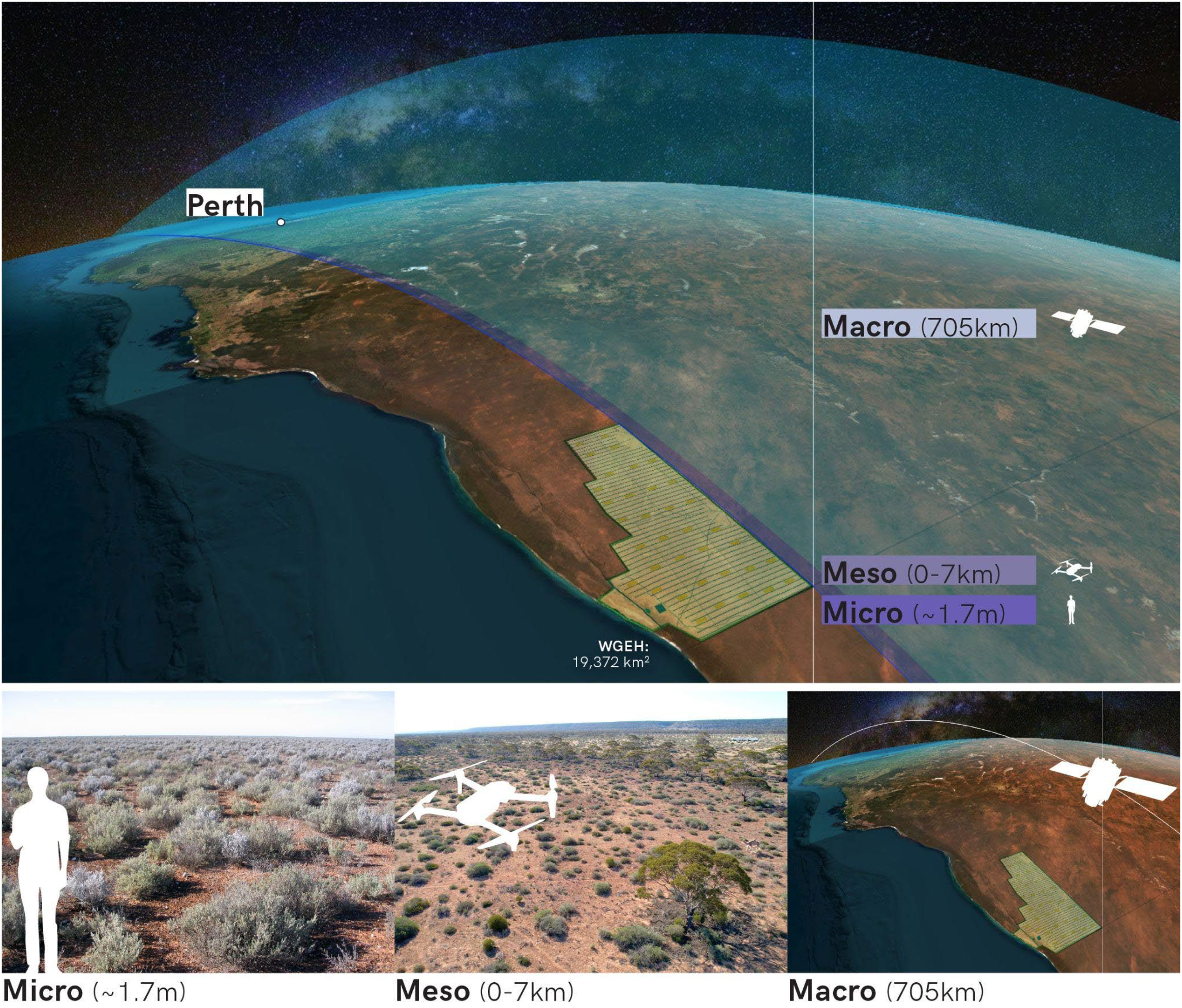
Macro, meso and micro landscape perspectives, here, contextualised to the focus case of the western green energy hub project in western Australia. Image: Josh Gowers & Zeunert.
To aid comprehension by general audiences, project communication in architecture and landscape design incorporate accurately-scaled drawings that concurrently utilise visual communication techniques such as three-dimensional ‘artist impressions’ and computer-generated walk-through animations (Amoroso, 2015). The incorporation of aesthetics, visual, analytical, and creative design communication techniques can further assist experiential understanding (Tufte, 1990). Scalar seeing visualisations enhance viewer abilities to perceive and understand implications and impacts. As such, scalar seeing is not merely a mechanical or technical practice, but an endeavour of creation and depiction embedded within the politics of space, representation, and multidimensional perception. As such, it reflects the relationship between epistemology and experience for “space is fundamental in any form of communal life” (Foucault, 1984: 252). Scalar seeing can empower a politics of witnessing that aids in the understanding of human experience, more-than-human relations, and planetary networks (McCosker and Wilken, 2014: 155).
Improving scalar literacy and comprehension of renewable megaprojects requires exploratory visual techniques and interrogative drawings, artwork, and theory. Zach Horton advocates for perception of a “cosmic zoom” (Horton, 2021) providing an example in Charles and Ray Eames 1968/1977 film, Powers of Ten. The Eameses’ nine minute film explores scales of existence using a consistent scale factor of 10, and human perception of these framings, commencing at the body, extending to the known limits of the universe, returning to the human and zooming into a proton of a carbon atom in a DNA molecule within a white blood cell (Figure 5). Powers of Ten personifies the fractal vision of complexity theory that was growing out of that era's trends in cybernetics and psychedelics, to conceive of structural verisimilitude across scales. Scalar seeing thus involves grappling with nested scales and the apertures on power they provide.
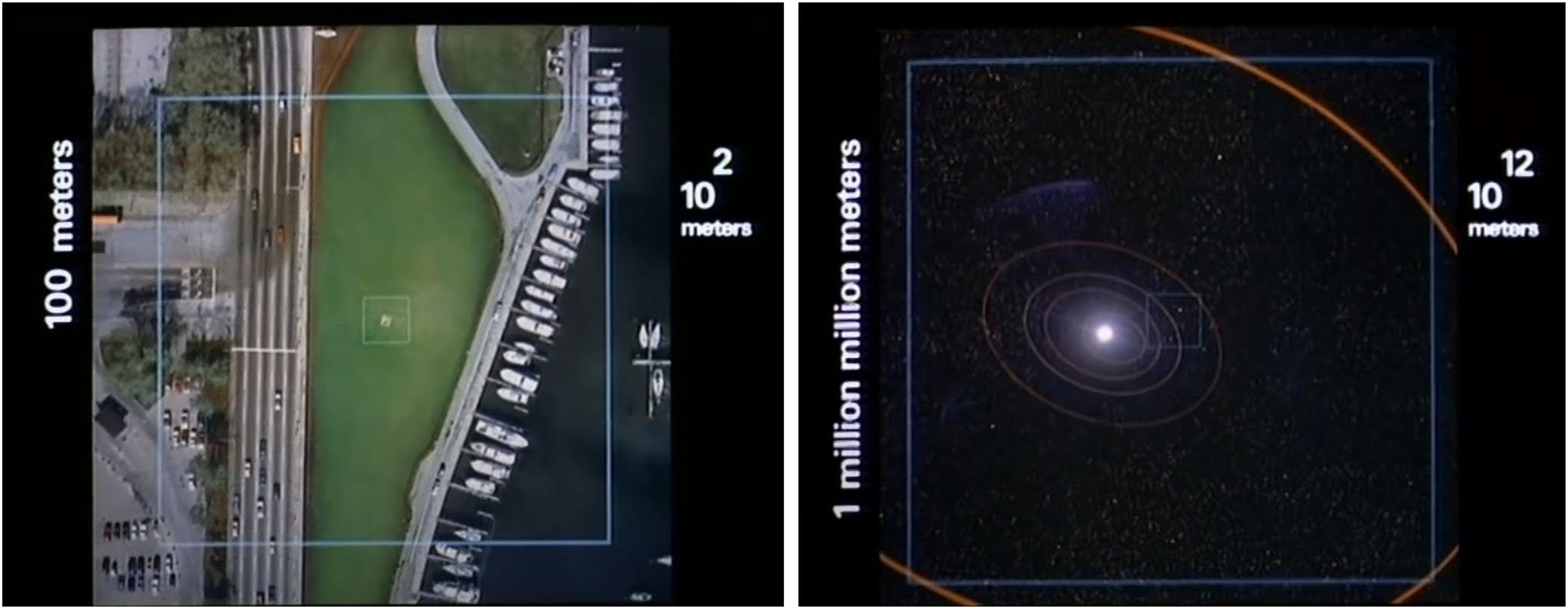
Meso (left) and cosmic (right) images from Charles and Ray Eames film, Powers of Ten. Image: YouTube.
Perceiving the markers of the Anthropocene requires scalar seeing, as humans may find it difficult to comprehend wider human and ecological relationships. Yet, thinking across extreme scales is “the crucial requirement of an aesthetic response to the Anthropocene” (Farrier, 2019: 20). Climate change is emblematic of the problem, an issue transcending borders and parochial minutiae. Electricity and heat production are the most significant human activity contributing to global greenhouse gas emissions at 35% (IPCC, 2015: 47, 88), paralleling Australia at 33% in 2019 (Commonwealth of Australia, 2019) and the United States at 25% in 2021 (US Environmental Protection Agency, 2021). Transition to renewable energy sources for electricity and heat production is therefore a global and national priority, and observing this marker of the Anthropocene can be facilitated by visual techniques improving scalar seeing. The article contributes to scholarship improving scalar literacy and comprehension of renewable megaprojects through exploring visual methods and generating interrogative drawings, artwork, and theory. Our exploratory methodological process combines drone images, scaled mappings and computer-generated visuals grounded in their postcolonial landscape contexts.
Methodology
This article combines two types of scalar seeing cases: the meso (middle) drone aerial image (Figures 2, 3, 6, 7), and the macro (expansive scale) computer visualizations (Figures 4, 8, 9–11). Meso scales of perception have advanced considerably through the availability of high quality still and video cameras in drones. The relatively affordable, trickle-down availability, and quality found in consumer drones have greatly democratised mid-level viewing and made landscapes perceptible in new ways. This has enabled novel ways of thinking and seeing the world, including citizen activism and protest, and the decay of the Earth's life-supporting spheres. The application of such methods will likely increase as drones proliferate along with imperatives towards landscape transparency during the energy transition.
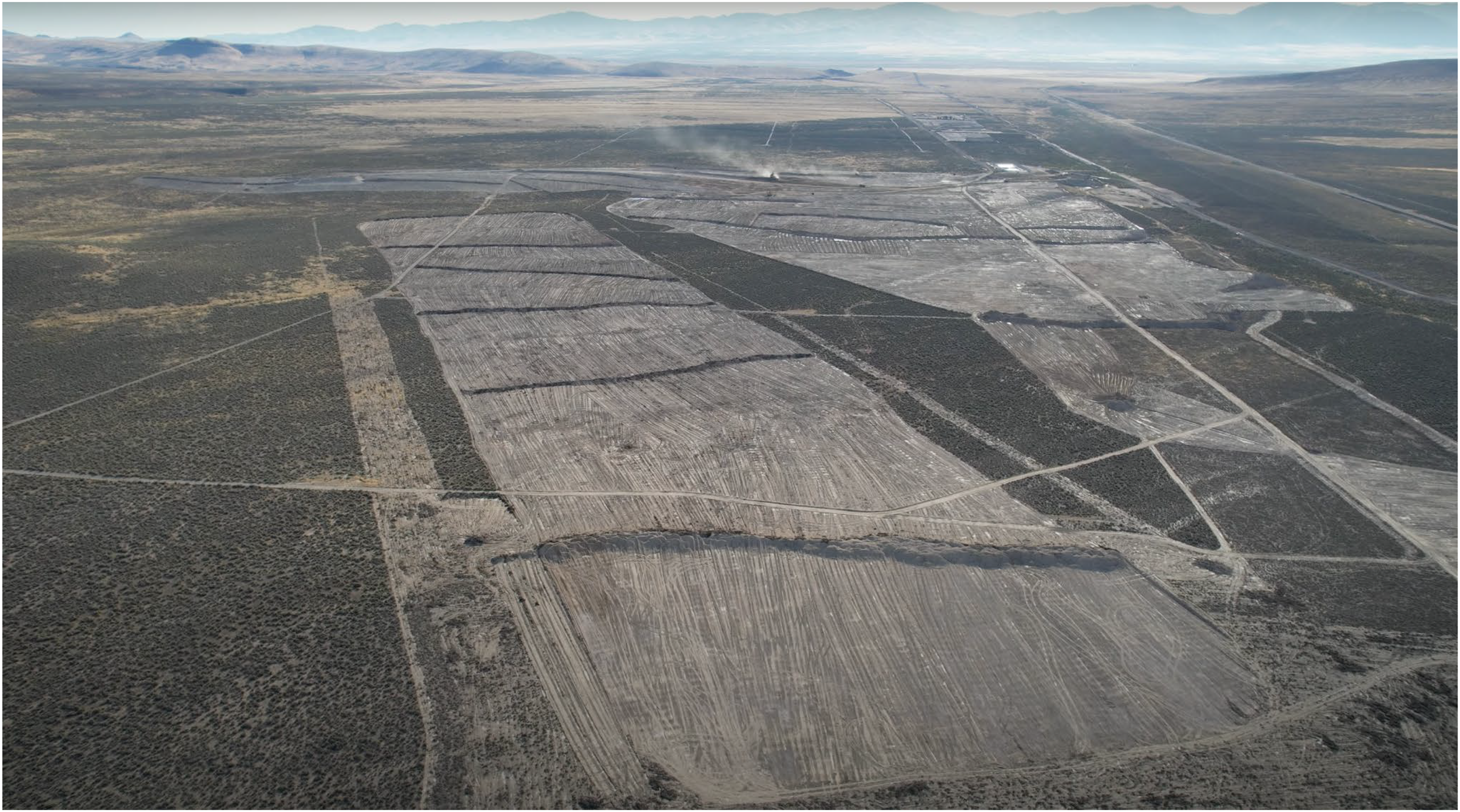
Initial land clearing at Thacker Pass Lithium, Nevada, USA, by drone. Drone image by Fish.

Meso drone view of part of the proposed WGEH site. Note the camel and road train for scale. Drone photo by Zeunert.
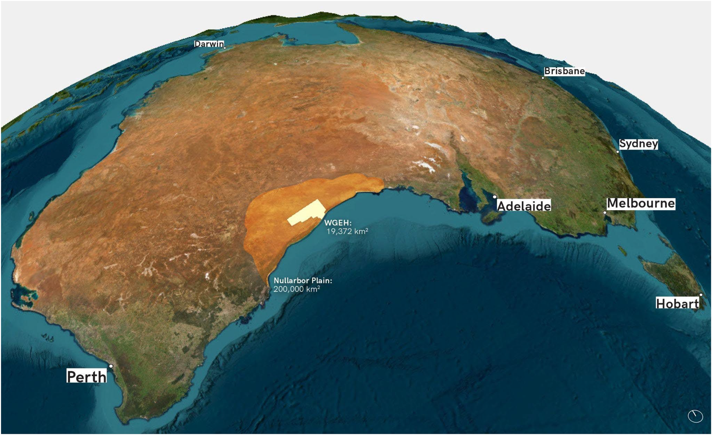
The western green energy hub in relation to Australia. Image: Josh Gowers and Zeunert.
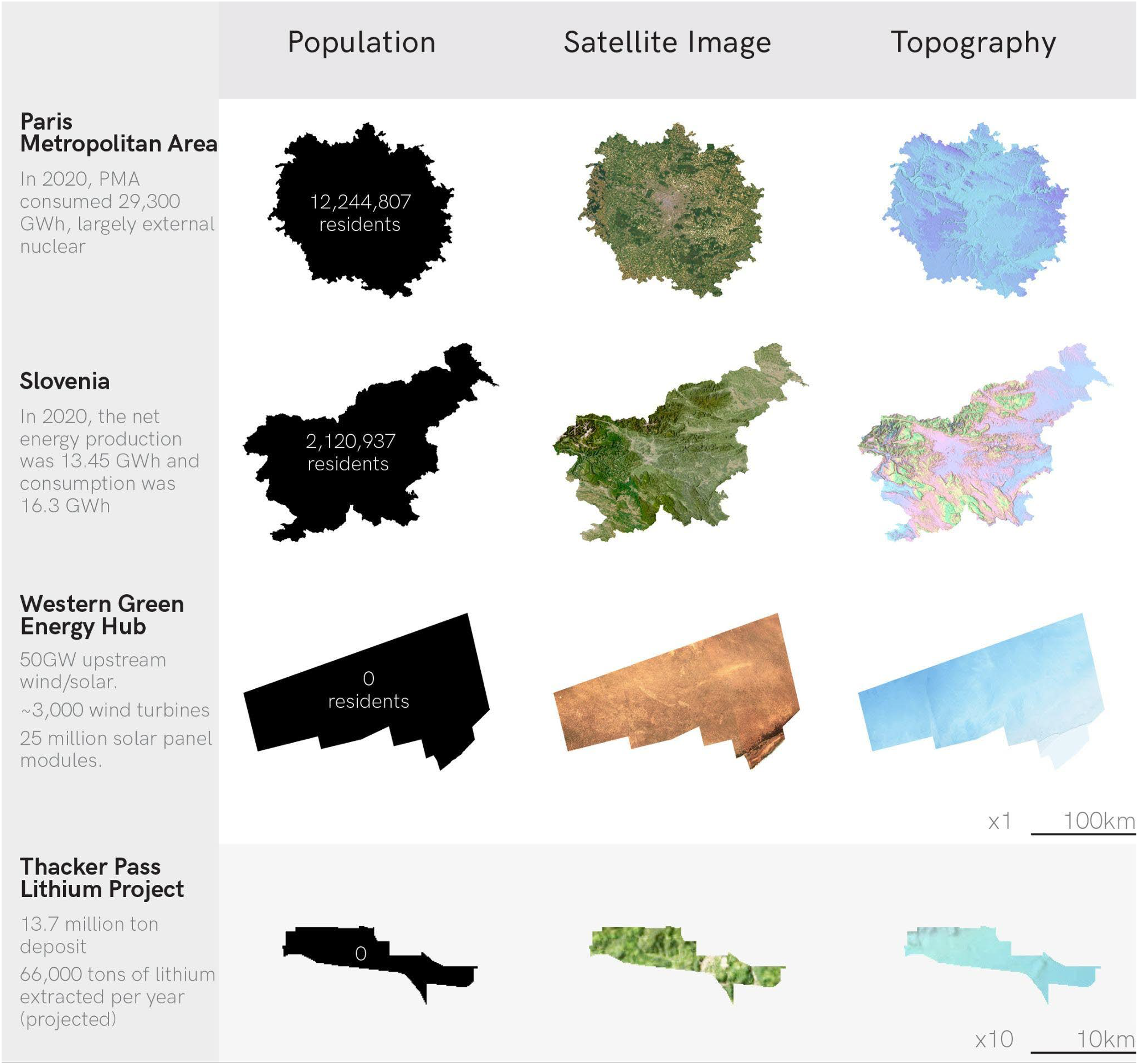
Comparison of Slovenia, Paris, WGEH, and thacker pass lithium mine. Image: Josh Gowers and Zeunert.
Inspired by the work of other drone piloting academics (Garrett and Anderson 2018, Hildebrand 2021) who flew drones to better understand the relationships between humans and technologies and seeing and knowing we conducted meso drone-based image collections of energy infrastructures (Figures 2, 4, 6, 8, and 10). Piloting drones is a practice freighted with ethical concerns regarding safety and privacy. Our fieldwork abided by UNSW Ethics approval as well as the Australian Government's Civil Aviation Safety Authority rules governing drone flight including not flying over populated areas, not exceeding 120 metres of elevation gain above takeoff, and keeping 30 metres away from individuals, none of whom were present during our flights. With the right preparation within these regulatory constraints important analytical work can be accomplished around industrial sites.
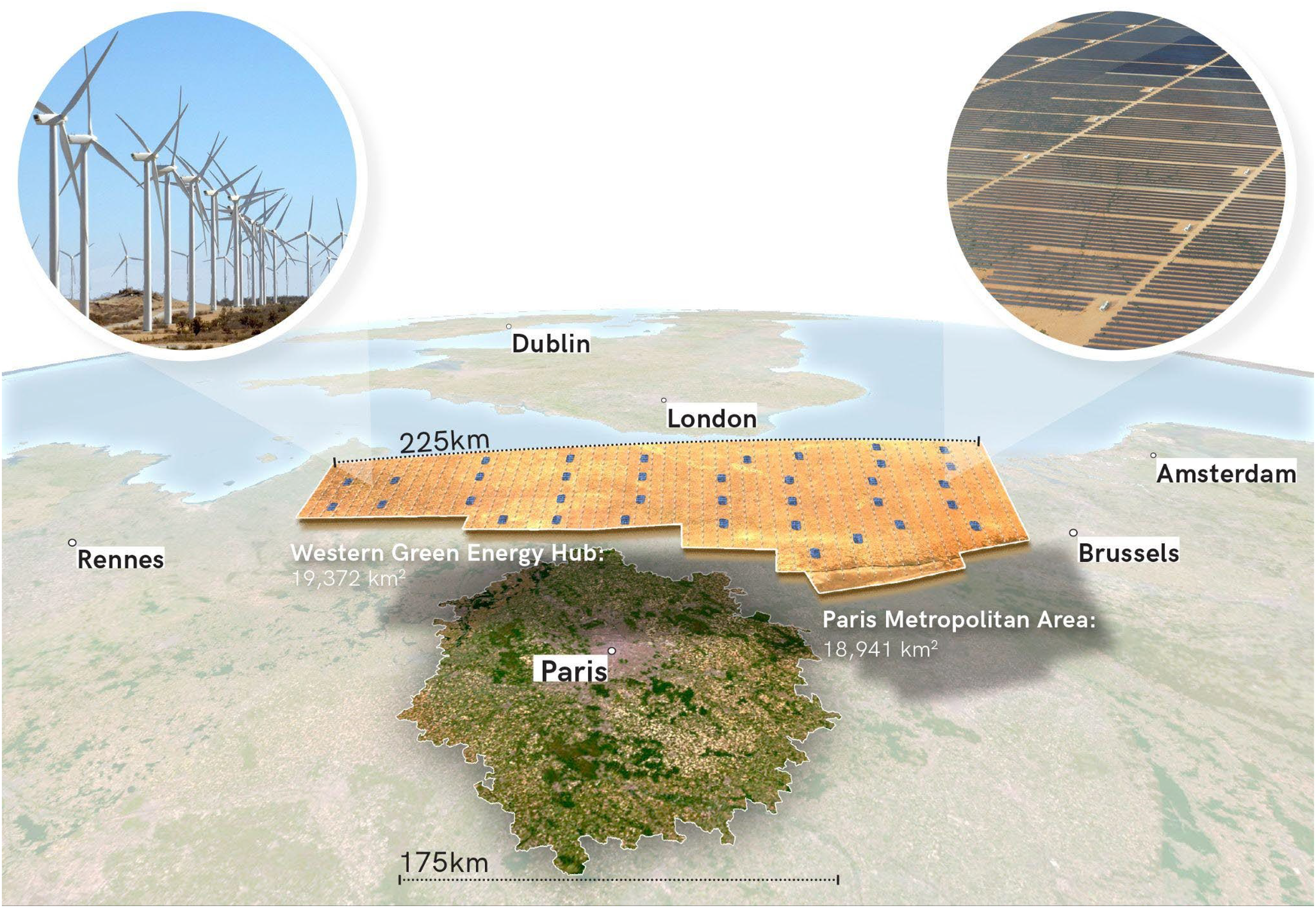
Overlay of the WGEH above the metropolitan area of Paris, France. Image: Josh Gowers and Zeunert.
This fieldwork often required a reflexive process of terrestrial recognizance with vehicles aided by Google Earth and other mobile satellite imaging platforms. Combining the terrestrial and the satellite, we identified ideal locations for drone take-off enabling us to acquire meso-level drone images of a range of energy infrastructures in the United States and Australia. With this collection of images we selected those for analysis which featured planned large-scale renewable energy infrastructure and a First Nations group that was involved in the project (Figures 4, 6, 7 to 11). With these criteria we selected the Western Green Energy Hub in Western Australia and the Thacker Pass Lithium Mine in Nevada, United States, for analysis.
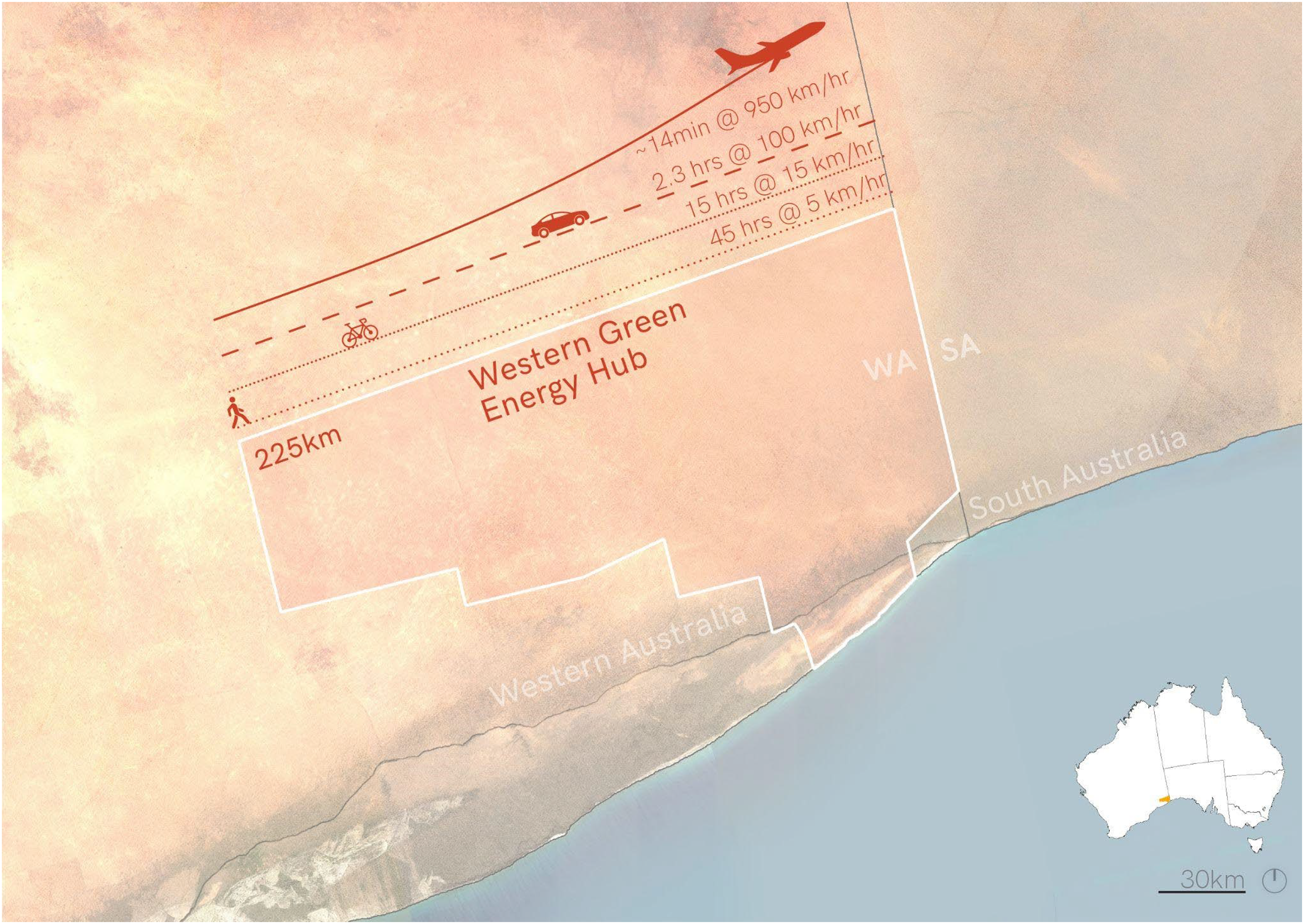
Times taken to travel the longest length of the Western Green Energy Hub by plane, car, cycling, and walking. Image: Josh Gowers and Zeunert.
The authors’ collaboration invokes Becker's (1974) argument for coalescence of sociological thinking and visual methods to further visual sociology, while building on Zuev and Bratchford's call to move away from the centrality of the photograph in furthering methodological insight (2021: 9). The consequent generation of computer visuals in this research involved conceptualisations stemming from [author's] spatial training, practice, and scholarship in landscape architecture and urban design. Initial scalar seeing conceptualisations were explored and tested via hand drawings, sketches and diagrams. These were transferred into computer drawing and visualisation programs for iterative development, validation, refinement, and presentation quality. Foundational was the usage of Geographic Information Systems (GIS) in ArcGIS, including utilisation of Esri World Imagery and WorldView-2 and Landsat 8 satellite photography overlaid onto a 3D globe. Both hand drawings and computer visualisations were creative processes involving iterative testing and revision to optimise clarity, legibility, and scalar seeing (Sawyer, 2021; Wynn and Eckert, 2017). Given the political and technical complexities and challenges inherent in the topic, the authors pursued a nuanced and exploratory approach avoiding absolutist or positivist research methodologies. Rather, our experimentalist strategies aim to avoid singular perspectives or criteria, improve perception and scale literacy, and help inform constructive dialogues amongst stakeholders and the public (Meyer, 2023).
The transition from fossil fuel power plants to wind and solar farms is occurring on disputed Indigenous lands in the United States and Australia. Many treaties between the United States government and Native American tribes were signed during the colonial period giving tribes legally defensible rights to land. This is not the case in Australia where no treaties were executed between the English Crown or the Australian government. However, affirming Indigenous rights to the land are the Native Title Act of 1993 and the Aboriginal Land Rights Act of 1976 which provide for communal private property ownership under freehold title. Understanding this and the immense Indigenous land requirements of the energy transition, we endeavoured to see—through our computer graphics and drone lenses—the renewable energy transition as fundamentally an issue of energy justice and Indigenous land rights in Australia and the United States.
This article draws from informal personal communications with renewable energy entrepreneurs in Australia and fieldwork with Aboriginal, Māori, and (Diné) Navajo renewable energy advocates. This collaboration with Indigenous people builds on Fish's 25 years of working on issues of Indigenous sovereignty around the world including several years as a tribal archaeologist for the Colville Confederated Tribes in Native America (2002–2005)–a community greatly impacted by renewable energy infrastructure in the form of hydroelectric energy development. As a Euro-American anthropologist, these experiences in Native American employment assist the authors in aligning energy scholarship and Indigenous values.
Case studies
From meso of the drone to the macro view of the computer visual
To improve seeing and comprehension of the magnitude of renewable energy megaprojects, the following case studies examine two methods of seeing from two different scales. First is the meso, or from the middle, which we accomplish with drone imagining of Thacker Pass Lithium Mine (Figure 6). Secondly, the macro, which we manifest with computer visuals of the Western Green Energy Hub in Western Australia (Figures 4, 7 to 11). This effort reveals both the limitations on seeing—even at different scales—as well as the political potentials to see what is hidden, obscured, or otherwise ignored. In our cases, this means the seemingly paradoxical eco-social impacts of renewable energy megaprojects. In the two cases that follow, we display and contrast two modes of representing renewable energy industries. The scale of the visions, the methods of image acquisition, and the political implications of the images are equally multiple.
Meso: drone images of indigenous owned renewable energy industries
Consider the following meso-views of the initial land clearing for Lithium Americas’ Thacker Pass Lithium Mine, the United State's largest and most complex lithium mine (Figure 6). The mine is projected to extract 66,000 tons of lithium per year from a total estimated 217.3Mt, and produce over 152,000 tons of CO2 annually, (equal to a small city) while consuming 1.7 billion gallons of water annually (500,000 gallons per ton of lithium produced). The area is in the traditional lands of the Numic speaking Northern Paiute who call the pass Peehee Mu’huh and oppose the mine.
Not the microscopic view from the ground which would obscure the site's context with the details of place, nor the macroscopic view that omits those same details–the meso drone view situates this megaproject in its environmental and geological context. And yet, despite its elevated position and high-resolution, this image omits important spatial but also historical facts. Lacking textuality and narration, such images at best evoke a sense of scale—but one that lacks comparison, isolated as it is in the Great Basin desert of north Nevada. To understand what the Native Americans and their allies are opposing means being exposed to story, controversy, and archaeology on the ground.
Facing the prospect of an open-pit lithium mine consuming 6000 acres of their cultural ecologies, the People of the Red Mountain and a number of other parties including the Reno-Sparks Indian Colony, the Summer Lake Paiute Tribe, ranchers, and four environmental groups have filed lawsuits against the project, with each effort being ruled in favour of the mining project (Sainato, 2023). Blockades against the mine by Indigenous peoples, landholders, and the public have been met with police raids and criminal prosecution. Michon Eben, Tribal Historic Preservation Officer for the Reno-Sparks Indian Colony, claims that Far Western Anthropological Research Group, the firm doing the archaeological and cultural impact statement assessment, failed professionally and ethically in their consultation and survey work (King and Young, 2022). She insisted that they desist from their work. Of particular attention was the issue of the September 1865 massacre of Northern Paiute by US colonists; such sites are protected by US federal laws. The archaeological firm contracted to complete the work prior to the permit being issued responded, stating that hundreds of small excavations were conducted in 2011 in the area of the massacre and no remains were identified (King and Young, 2022).
These histories and present-day accusations are diffracted through the act of flying a drone at the meso level above the Thacker Pass Lithium Mine. By diffraction we refer to visual interferences that reveal interactions otherwise imperceptible (Barad, 2007). The marks on the landscape are not only the signs of industry but also of the otherwise hidden world of the conflictual past. The Native Americans protesting the mine feel that their procedural energy justice has been interrupted—they have not been properly consulted on this project's development and it is proceeding without their authorisation. The cuts in the terrain are not symbols of this injustice but indices of that interaction. The drone is a tool for meso-level seeing that surfaces the visual aspects of these eruptions. In this manner, the drone is entangled with the energy industry, documenting the land art-like manipulations of the lithium mining company. The drone aestheticises Earth manipulation in a way that both familiarises and defamiliarises the energy industry; its flight and the images that result both bring energy infrastructure into clearer focus while also showing its otherworldly size.
In the next section we complement this brief analysis of what the drone's scalar seeing reveals about the cultural aspects of renewable energy megaprojects with a study of computer visuals from a higher elevated position. What we find is that with an enhanced sense of scale different marks of cultural politics are revealed.
Macro: drawing Australia's renewable energy mega transition
The Western Green Energy Hub (WGEH) is a megaproject by InterContinental Energy and CWP, that will be the world's largest renewable energy hub if completed in 2030 (US$70B). Mirning Green Energy is a wholly-owned subsidiary of the Mirning Traditional Lands Aboriginal Corporation and will own 10% of WGEH should it be developed. Figures 4 and 7 use GIS to convey the scale of the project and Figure 8's drone aerial image shows remnant endogamous vegetation present on part of the site area.
Proposed to function by 2030, the WGEH is slated to eventually produce 50 gigawatt (GW) of energy production, which will partly be used to generate green ammonia and green hydrogen using renewable energy sources of electricity rather than fossil fuels. The project requires 15,000 square kilometres to achieve its slated output (WGEH, nd.b). To put this into context, Australia's current largest power station, Eraring (coal/diesel), is 2.9 GW and occupies 9.4 km2. We calculated the WGEH site investigation area by GIS as 19,372 km2, which is similar in size to the country of Slovenia and the city of Paris—shown in plan views in a small multiples drawing (Tufte, 1990) (Figure 9) and aerial visualisation (Figure 10).
To increase scale and spacetime literacy of renewable energy megaprojects, Figure 11 calculates its longest boundary dimension of 225 kilometres in relation to four transportation modes: commercial aircraft (travelling at 950 km/h); motor vehicles (travelling at 100 km/h); cycling (at 15 km/h, accounting for unsealed service roads); and, walking (at 5 km/h). Based on these four modes, it would take over 14 min to fly over the hub's 225 km-long northern boundary by (fast) commercial aeroplane; 2 h and 15 min by vehicle travelling continuously at 100 km/h; 15 h if cycling continuously without a break at 15 km/h; and 45 h, or nearly two days, if continuously walking at 5 km/h. The question remains: how does this attempt at improving scalar seeing enhance actionable awareness of Indigenous energy justice?
These computer visualisations reveal much through scaled comparison but the aporia they do not reveal is Indigenous energy justice. Regarding Mirning involvement, Chairman of the Board of WGEH Brendan Hammond said, “We do not see the involvement of Traditional Owners as being anything other than a vast opportunity at both the project level and corporate level” (Fish, personal communication). CWP Development Director Andrew Dickson claims that the Mirning are key stakeholders who “now have equity in the project. And they have a board seat. And they're not just engaged with, you know, like a third party, but they're actually a core part of the project consortium” (Fish, personal communication). As previously stated, the Native Title Act provides for inalienable private property ownership. Under the Native Title Act an Aboriginal or Torres Strait Islander community can establish a prescribed body corporation and register it under the Corporations (Aboriginal and Torres Strait Islander) Act of 2006. Like other opportunities made possible by Native Title, Mirning partial ownership is a result of this legislation, their Native Title being recognized in 2017, and the corporate social responsibility of the developers. Also, the WGEH is a potential because of the internal factors of the Mirning's cultural activism to collaborate with these developers.
Discussion
The global transition from energy-dense, below-ground fossil sources of coal, oil and gas—the trinity driving planetary climatic instability—to low energy density, above-ground sources of wind and solar energy (Stremke and Dobbelsteen, 2013) requires extensive new areas devoted to energy generation, primarily using solar, wind, and battery storage. The need for extensive spatial areas is compounded by unprecedented output capacities of proposed renewable energy megaprojects that are poorly understood due to a lack of scale literacy and a deficit of visualisations adequately conveying their sizes alongside texts reporting historical events, present day protests, and current corporate partnerships. Without this full picture, seeing is not sufficient for political action.
Our visualisations of Thacker Pass and WGEH reveal the deficit of communication and spatial comprehension of renewable energy megaprojects. This paper prompts improved appreciation of unprecedented spatial scales of renewable energy megaprojects, and the resultant ramifications and impacts they catalyse. This is based on centuries of colonial-cum Federal land, mineral, and resource enclosures. Both equate to concealment and mitigation of visual conflicts—to which the scales of examined renewable megaprojects in this research necessarily defy. This is reflected in politicised campaigns in Australia against wind turbines based on visual, noise, biodiversity, and agricultural objections, amidst recurrent political pushes for nuclear energy (author). A multi-decade period of evolving Native Title and Aboriginal Corporations in Australia and similar legislative and corporate developments in the United States represents fundamental partnerships needed by renewable project proponents to proceed.
Overarching these issues is a globalised modality of economic growth in an extractive economy (Lines, 1991), which sidelines environmental, energy, and multispecies justice. These factors, as well as immense supply chain and logistic operations needed to manifest megaprojects in remote locations, coalesce to represent complex headwinds for realisation of renewable energy megaprojects. Despite these complexities and their importance, renewable energy is the most effective means of mitigating global greenhouse gas emissions to help address Kunstler's notion of the “long emergency” (2006) and Nixon's concept of “slow violence” to avoid “calamitous repercussions playing out across a range of temporal scales” (2011: 247). The scale of renewable energy megaprojects required is revelatory of human resistance to uncompress the fossil fuel era's accelerated spacetime continuum.
This research contributes scholarship and visualisations to seeing energy at scale—how seeing is relative to technological perspective, space, energy regimes, and historical context—to generate a theory of seeing at multiple scales. The cases in this paper contribute to the necessary but incomplete project of scale literacy, which is particularly important given the unprecedented spatial consumption wrought by renewable energy development. The cases demonstrate the strength of the drone view and its meso-vision, illuminating a scale gap between on-ground and satellite imagery, between history and presentism. The meso drone perspective is, however, incapable of capturing the full-scale of emergent renewable energy installations and the underlying colonial inequities.
To see megaprojects more fulsomely, computer visualisations illuminate comparatively-sized elements which may assist interpretation of their behemoth footprints. Such scalar seeing techniques are a crucial tool to help navigate the politics of energy landscapes, particularly to assist prior and informed consent by First Nations custodians. Otherwise, the perils of green land grabs risks a new deleterious sacrifice, in the name of alleviating planetary heating. Megaprojects, however, represent the scales required to transition from dense and compact fossil fuel energy generation modes, to diffuse and spatially expansive techniques harnessing wind and solar energies in order to decarbonise and mitigate global heating. While their spatial brutality may be difficult to accept by diverse communities living within their orbit, they ultimately represent a forfeiture, given the lack of appetites for voluntary degrowth. Visceral means of image capture and representation can help people understand implications and impacts of the renewable energy transition on First Nations groups and local ecologies.
Conclusion
Collecting the lithium, the solar photons, and wind currents to make the transition from fossil fuels to renewable energy requires large-scale transformation of landscapes–many of which Indigenous people have long cared for and are legally entitled to benefit from. While the infrastructures of the fossil fuel industries have become visually familiar to many humans–as have the expansive fields of solar panels and arrays of wind turbines anchored into surface and sea floors–understanding how these energy industries impact landscapes requires seeing them before and during ground disturbing activities. With such visions an enhanced grasp of what constitutes energy transition and how it intertwines with the energy justice of recognising the consequences of renewable energy development for the Mirning and Paiute, and Indigenous communities worldwide, can emerge. The drone from the meso, the computer visualisation from the macro, these two seeing methodologies complement each other presenting a more fulsome depiction of the potential consequences of industrial development. Many important elements are omitted. Colonial massacres and partial degrees of ownership over renewable energy infrastructure are just two issues diffracted by our drone piloting and computer visualisations. It is these limitations on seeing that this article reveals. The pairing of textuality and visuality, like that linking interpretation and depiction are essential to understanding the scale of human places and humanity's place in this world.
Footnotes
Acknowledgements
The authors acknowledge Research Assistant Josh Gowers for his digital generation of figures and assistance with the article.
Conflict of interest statement
The authors possess no conflicts of interest.
Funding
The author disclosed receipt of the following financial support for the research, authorship and/or publication of this article: This work was supported by the UNSW Scientia Program.
University of New South Wales, (grant number Scientia Program).
Correction (March 2025):
The word “author” has been changed to “Zeunert” in captions of Figures 2, 4, 7, 8, 9, 10, and 11.