
Abstract
The original Cerdà plan (Pla Cerdà) of 1855 for the extension of Barcelona is famous for its grid array of large blocks and wide streets to promote circulation. Each block was originally intended to have an area of open space in the center to provide for the needs of residents. Already by the 1920s, however, the center of the blocks had been filled with buildings. Barcelona currently suffers from a chronic lack of open space, excess noise, and air pollution that exceeds European Union law. This article aims to trace the agency of play as a dynamic process in urban planning to provide new sources of open space through Superblocks (aka Superillas and Supermanzanas). We begin with a brief history of their implementation in the city of Barcelona and the evolution of their justification from the 1990s onward. We then explain the capacity for urban transformation that Superblocks have and how they can modify the urban mobility model and the public space model. We then analyze the role of different forms of play that are used in the area of Poblenou to suggest how play can be used to increase the legitimacy of public participation. Finally, we observe the contingent role of play within urban socialization and in motivating and shaping the urban planning processes of implementing Superblocks.
The New Rules of the Game
Urban areas globally are at the center of a paradigm shift in the way that we live, as public space given over to car mobility is ceded back to the movements of pedestrians and cyclists. A new urbanism that repurposes existing spaces to create sites of new cooperation and interaction between citizens is needed (Rueda Palenzuela, 2017).
Play has an important role in this transformation of urban spaces. As an organic, open-ended, phenomenological, and heuristic mode of interaction, play holds open the possibility of a range of activities and goals, encompassing the economic, social, physical, and intellectual spheres. Play has been variously used in relation to the planning and designing of public open spaces to involve citizens in planning cities, to engage them in collective issues of concern, to build trust, and to create meaningful memories (Ashtari & de Lange, 2019; Schouten et al., 2017).
Cities are highly resistant to large-scale physical transformation because of their overlapping layers of existing infrastructures. A sudden increase in public space in a city is a relatively rare event. Rarer still are those cities that can use this reorientation as an opportunity for the mass creation of new urban spaces for play. One notable 20th-century example is the work of Aldo Van Eyck, who designed 770 playgrounds in Amsterdam between 1947 and 1978, taking advantage of the modernist zeitgeist that placed children’s wellbeing at the center of European urban post-WWII reconstruction efforts (Katsavounidou, 2018).
In the following, we critically examine the more recent and ongoing efforts to radically increase the amount of public open space in Barcelona and the challenges that have been faced in maintaining a focus on play while reorienting the city away from car-based mobility. Barcelona’s transformation plan employs Superblocks, which are clusters of urban development, within which buildings are connected by car-free pedestrian and bicycle pathways, with the cluster being externally bounded by larger, higher speed roads that provide vehicular traffic connections across the wider city (Birch, 1980).
Superblocks have attracted attention internationally as a tool for urban reform that reduces the movement and dominance of the car (Kan et al., 2017; Scoppa et al., 2019; Scudellari et al., 2020). While they have been implemented in smaller Spanish cities including Vitoria-Gasteiz (Civitas MODERN, 2020) and Figueres (Rueda, 2014), Barcelona is the largest city to have adopted them as a guiding principle for the whole city. Barcelona makes a key case study because of the deep commitment of its public institutions to creating channels for residents to participate in public processes, despite a long and difficult history of public participation in some parts of the city (Estévez, 2019). The Barcelona case has particular relevance to recent efforts by cities worldwide during the COVID-19 pandemic to use temporary interventions to close streets to cars and reconfigure these urban spaces as a playful, exploratory way to meet changing social and health needs (Daly et al., 2020).
In 2000, the development of a total of 503 Superblocks stretching across the city of Barcelona was proposed by the Urban Ecology Agency (Agència d’Ecologia Urbana de Barcelona, officially abbreviated to BCNecologia), a public consortium integrating the environmental concerns of the Àrea Metropolitana de Barcelona (the regional authority), Diputació Provincial de Barcelona (the Provincial Council), and the Ajuntament (Barcelona City Council). The proposed city-wide implementation of 503 blocks was driven by the need to reduce car movements and associated noise, nitrous oxide, and other pollutants producing an estimated annual reduction of 667 premature deaths (Mueller et al., 2020). Barcelona has 31 Superblocks in current development. Three of these have been in the vanguard of Superblock adoption: the districts of Sant-Antoni, Poblenou, and Horta. The reflections in this article are drawn from this experimental implementation.
This article aims to examine the implementation of Superblocks in Barcelona and to describe the challenges of ensuring that play is taken seriously by practitioners as a use of public space. Our view is necessarily subjective because of the involvement of one of the authors as both the instigator and the leading advocate of Superblocks in their current form and Director of BCNecologia until 2019. This essay is therefore intended to be a reflection and provocation to other decision makers on their use of opportunities to remodel urban spaces and ensure the implementation of spaces for play in contrast to a long-standing emphasis on mobility at the urban scale.
In the next sections, we describe how an interplay between the rights to the city and the rights to difference creates an opportunity for play. We then analyze how the original grid network was conceived in the Cerdá plan and has since evolved, with Superblocks being the latest concept to shape the city. We point out attempts to reduce and reshape mobility in cities internationally and critically reflect on the support that the Superblock idea attracted while noting that planners in Barcelona are still more likely to see the street as an area for mobility. We conclude by unpacking the lessons from the design of play in recent Superblock history for urban planning and design.
Uses in Public Space and Citizen Rights: From Pedestrians to Citizen
One of the most radical aspects of Barcelona’s Superblock proposal is the planned conversion of most of the urban space from the monofunctionality of traffic streets to a multiplicity of uses and rights. This is radical because it goes to the roots of the meaning of public space. A city exists when, first, there is public space and, second, when they are reunited in a limited space by a determined number of legal entities that are complementary and “work” synergistically. Much first-world urbanization is characterized by detached houses and offices with attached garages where occupants can walk to their cars. In this case, we can talk about urbanized space but not public space. Urbanization alone does not require marketplaces, cultural events, or children playing with balls in the middle of the street (Rueda, 2019). A city starts to become a city when there is public space, as it is the “house of everybody,” the meeting place for leisure (including the play of children, and adults) and stopping, exchange, culture, expression, and democracy. Public spaces are also the space for human movement. Public space makes us citizens when we have the possibility of occupying it for the exercise of all the rights mentioned earlier. Today, the limited possibility of exercising citizen rights relegates us to a limited role as mere pedestrians. Giving citizens back public space that was lost to the dominant model of mobility is key to the new model of public space and mobility.
Such a conception of urban public space focuses on the value of the city as more than just a place that maximizes the production and circulation of people and goods, but “as an oeuvre, as an end, as a place of free enjoyment, as domain of use value” (Lefebvre, 1996, p. 126). Lefebvre (1991b, 1996) characterizes the city in terms of two fundamental citizens’ rights. First, “The Right to the City” is defined by the concentrated assembly of people and their activities in space, and their active participation in managing and developing that space to serve a rich variety of social needs. Second, “The Right to Difference” highlights that this concentration of diversity leads to differentiation, the identification of new needs, and new activities. These two conditions give rise to a third: the concentration and mixing of diversity in city spaces frame opportunities for play (Stevens, 2007).
Urban Spaces and Play
The concept of “play” can be applied to a wide range of aspects of social life. It spans a great diversity of forms, players, and contexts. Its definition and value vary depending on different arguments people are trying to make about social life and about how urban planning should support or shape it (Sutton-Smith, 1997). Three broad perspectives on play draw our attention to different social needs it can fulfill, and thus its potential relevance for urban planning, and to Barcelona’s Superblock as a specific planning approach for urban space. First, play is most widely understood as having practical value, as a mode of exploration and learning that is crucial for the physical, mental, and social development of children. Much recent interest in play in cities has focused on its further practical benefits in terms of supporting physical and mental health (Gruebner et al., 2017; Tonkin & Whitaker, 2019), including in the case of Barcelona (Mueller et al., 2020). Within this frame, play should be healthy, safe, and productive. Second, play has cultural significance as a luxurious, wasteful activity consciously separated from immediate practical needs. This is the most common understanding of adult play. Key forms of such play include games, which are only pursued for their own sake and for social interaction, and stimulating experiences such as skating, carnival rides, theater, and exploring. Quite in opposition to the first view, here play is seen as useless or even disruptive to practical goals (Caillois, 1961). Cities are key sites for these kinds of nonpractical play (Stevens, 2007).
The third broad way of understanding play is dialectical as a lived critique within the social life of its limitations and dissatisfactions (Lefebvre, 1991a). Many play activities involve challenging the constraints of what is known, acceptable, and practical. For example, games of chance, competitive play, and imaginary, creative play all give people opportunities to escape from and overcome the limits of society’s existing structures, practices, and ideas. The concentration of diverse people in urban spaces can also stimulate play because of the frequent, unexpected encounters and interactions among people who are different. Such interactions can prompt spontaneous and creative action, the discovery of diverse needs, and the realization of new social possibilities (Lefebvre, 1996). Temporary official and unofficial closures of streets for festivals, parades, and contests demonstrate different possibilities for how an urban street might be used. For example, costumed protest marches and unofficial appropriations of city streets by cyclists during Critical Mass and Reclaim the Streets are playful (and therefore tolerated) ways of challenging the functional allocation of most urban outdoor space to vehicular traffic (Stevens, 2007). The COVID-19 pandemic has propagated a great expansion and formalization of such experiments, including part-closures of major streets in Barcelona (Daly et al., 2020). As we discuss later in this article through the case of Barcelona, play is thus a key element and objective within urban planning strategies that seek to challenge existing planning paradigms (such as automobility), and play is also being integrated as a mode of action, experience, and social engagement within formal processes of planning and decision-making for cities (Ampatzidou et al., 2018; Poplin, 2012).
Play is typically set apart in time and space from the rest of everyday life and follows different rules. Play can variously take place in liminal zones (Stevens, 2007, p. 52), in “Spielraumen” (Katsavounidou, 2018) that lie in the crevices of urban life, as a “guileful ruse” deployed by those who use tactics because of their strategic weakness (De Certeau, 1984, p. 37). Such heuristic and phenomenological practices suit urban spaces that can be easily reconfigured. It involves pretending and acting out alternative social realities in a limited way. The separate, not-real, and not-serious quality of play gives people the opportunity to playfully explore different social worlds with new possibilities for action and social interaction. Play can offer a behavioral, social, and spatial context of freedom, safety, and equality that is not available in serious everyday life (Caillois, 1961; Huizinga, 1970). Play provides an important means for expressing and addressing people’s needs for social belonging, esteem, self-actualization, cognitive and aesthetic experience, and self-transcendence (Maslow, 1943, 1970) Several of these needs—affiliation, esteem, and self-transcendence—point toward fundamentally social aspects of play. Many forms of play engage us with other people—particularly when they occur in urban spaces. Contemporary urban societies that have increasing wealth and leisure time thus focus increasingly on how the design and management of cities and their spaces can enhance the urban population’s social needs, their enjoyment of life, and play (Lefebvre, 1996, 2014).
The imaginative, expressive, social, and critical dimensions of play characterize its potential as a performative critique of everyday urban life, and in many cases, of the ordinary uses, meanings, forms, and management of urban spaces. Its pretend dimension allows the expression and testing of actions that may not usually be sanctioned. By playing in public settings, people discover and develop new repertoires of action, and also act out new uses, meanings, and values for the spaces where they play, often engaging strangers either passively or actively in these playful activities.
Donoff and Bridgman (2017) identify a typology of ways that urban environments can provide “play spaces” that stimulate and nurture adult play, drawing on an analysis of 27 existing and proposed play-focused urban design interventions. This typology encompasses a range of play types and key design dimensions as well as different modes of implementing ludic objectives into urban design. Their analysis of various ways that urban design interventions can engage people in play emphasizes the key importance of urban spaces that large numbers of people pass through—for example, streets that are well-connected to the wider city, such as those in Barcelona’s gridded Eixample. Börjesson Rivera et al. (2019, p. 97) emphasize that playful social encounters require people to be stationary or at least to move slowly. In this context, they identify a wide “range of problems with cars(,) that (have) negative implications for playable cities.”
Donoff and Bridgman’s analysis identifies several important contextual aspects of the urban environments where play can happen. The enjoyment of different forms of sensory stimulation, such as sound installations, requires that people are set apart from the noise and vibration of vehicular streets and free from the need to constantly watch out for traffic. Equipment that enables playful forms of movement such as adult swings and slides needs to be placed in locations where people in motion will not collide with vehicles. Donoff and Bridgman’s central focus on interventions also highlights that infrastructure and experiences in the public realm can be playful because they transform the expected function of urban spaces, by occupying an unexpected or unnoticed location, having an element of novelty or temporariness, or because they are unofficial (Stevens, 2007). Enabling play can thus involve reimagining and reperforming the functionalized landscape of vehicular streets.
It is revealing that most of the subsequent research drawing on Donoff and Bridgman’s study focuses on children’s play, its importance for learning, and practical needs for health and safety. Donoff and Bridgman themselves draw upon a range of research to highlight that play also supports adult well-being in ways that extend well beyond measurable physical and mental health. They link play to the kinds of “higher-order” needs identified by Maslow (1943)—“learning, self-actualization (and) creativity”—and to people’s desires for connection with their surrounding community (Donoff & Bridgman, 2017, p. 297, quoting Kerr & Apter, 1991).
In spatial terms, Lefaivre and Döll (2007) suggest that urban play can be optimized when various ludic interventions are connected together as a network, providing interstitial opportunities for play along the everyday pathways that people travel through the city. Donoff and Bridgman (2017) also discuss ludic interventions that are positioned in busy pedestrian urban areas where they will encourage engagement, such as pedestrian crossings. This accords with empirical observations made in the 1960s by Gehl (1987) and Whyte (1980) that people often stop to engage in playful actions and social interactions during their practical journeys through the city and with Gehl’s insight that stationary activities are a key measure of the quality of urban spaces because they reveal people taking time out for “unproductive” play. As we see subsequently, slowing or stopping mobility is a critical aspect of the Superblock.
Reclaiming Urban Streets for People and for Play
The abovementioned analyses of specific spatial conditions that support play in cities draw attention to the key importance of streets and to long-standing efforts by urban planners to design and manage urban streets to encourage their use for walking, stopping, socializing, and play. Most streets in European cities were laid out before the automobile was invented and so even wide and straight streets such as those in Barcelona’s Eixample were designed with a view to carrying slow, mixed traffic of pedestrians, horse-drawn vehicles, and trams.
Already in the 1920s, urban planners were reacting to the problems caused by automotive transport and parking in cities, and new health-related ambitions to ensure adequate open space for residents, by creating separate street systems for high-speed, long-distance travel and for local traffic, such as Le Corbusier’s Modernist 1925 Plan Voisin for Paris with its grade-separated freeways. In the United States, Clarence Stein and Henry Wright developed the residential estates Sunnyside Gardens (from 1924) within New York’s gridiron plan, with through-block pedestrian connections across its large landscaped courtyard blocks, and Radburn (from 1929) “a town for the motor age” (Stein, 1949). Radburn provided pedestrian-only Superblocks linked by vehicle-free pathways. But these paths were completely separated from the vehicular street network that connected to the front of properties and were set within wide green spaces. Being a low-density commuter suburb of detached houses, Radburn offered limited prospects for social interactions on its pedestrian pathways. Both schemes ultimately orient outdoor activities inward, to the immediate neighborhood, not outward to the wider city (Jacobs & Appleyard, 1987).
The explosion of private car ownership in the United States and Europe in the 1950s and 1960s precipitated further research and planning to document and limit the negative impact of motorized vehicles on urban street life. Europeans began (re)pedestrianizing streets in downtown shopping areas, starting in 1953 in Kassel, Germany. Copenhagen’s main shopping street, Strøget, was narrow, and the city’s compact center was quickly choked with moving and parked cars. Strøget was temporarily closed to cars in 1962, and pedestrian numbers leaped to 35%. The street was then permanently closed in 1964 and was the focus of Jan Gehl’s (1987) pioneering and influential study of how people actually used urban street space, Life Between Buildings (first Danish edition 1971). Copenhagen’s pedestrian shopping zone, like many, has continued expanding into an irregular Superblock that now provides 100,000 square meters of pedestrianized space—equivalent to 44 blocks of street space within Barcelona’s Eixample. An important finding of Gehl’s ongoing study of Copenhagen’s pedestrianized streets is that although the number of pedestrians using Strøget remained constant from the 1960s to the 1980s, the number of people involved in stationary activities within the street had increased substantially (Gehl & Svarre, 2013).
The concept of the Woonerf (“living street”) was first developed in the Netherlands in 1977, in response to high death tolls from traffic accidents in the early 1970s. This was the first time streets in existing residential areas were, like Barcelona’s, repedestrianized to meet safety and social needs. The Woonerf approach included removing separated footpaths and turning the entire street width into a single shared surface for pedestrians and vehicles, installing traffic calming measures such as rough surfaces, bollards, and chicanes, and limiting vehicular speeds to walking pace. The Dutch transport planner Hans Monderman took the idea of sharing urban space a step further by removing lines on the road and signs to make driving a car feel insecure and uncertain (Monderman et al., 2006). This pushed the responsibility for managing the inherent contingency and uncertainty of pedestrian mobility in urban areas onto car drivers, rebalancing the uses and rights of streets.
Donald Appleyard’s Liveable Streets (1981) provided a contemporaneous, detailed, and empirical analysis of the social impacts of high street traffic on urban social life. He compared social relationships among residents of three San Francisco streets with similar built forms, but which carried quite different levels of car traffic, averaging 2,000, 8,000, and 16,000 vehicles per day. Appleyard showed that people living on the street with the lowest volume of car traffic were more satisfied and had three times as many friends as people living on the high-traffic street.
Despite decades of research and incremental increases in pedestrianization, currently in Barcelona, as in most cities, vehicular mobility remains the predominant use of public space. Despite many efforts by planners and engineers to moderate urban traffic speeds, mobility planning typically delivers dysfunctional urban spaces. In Barcelona, 85% of roads are dedicated to vehicles, and 60% of public space in general is dedicated to mobility. The resulting situation is analogous to a famous cartoon by the Swedish artist Karl Jilg (Figure 1). Crossing a road or walking on a footpath is as laden with risk as balancing over or next to an abyss.
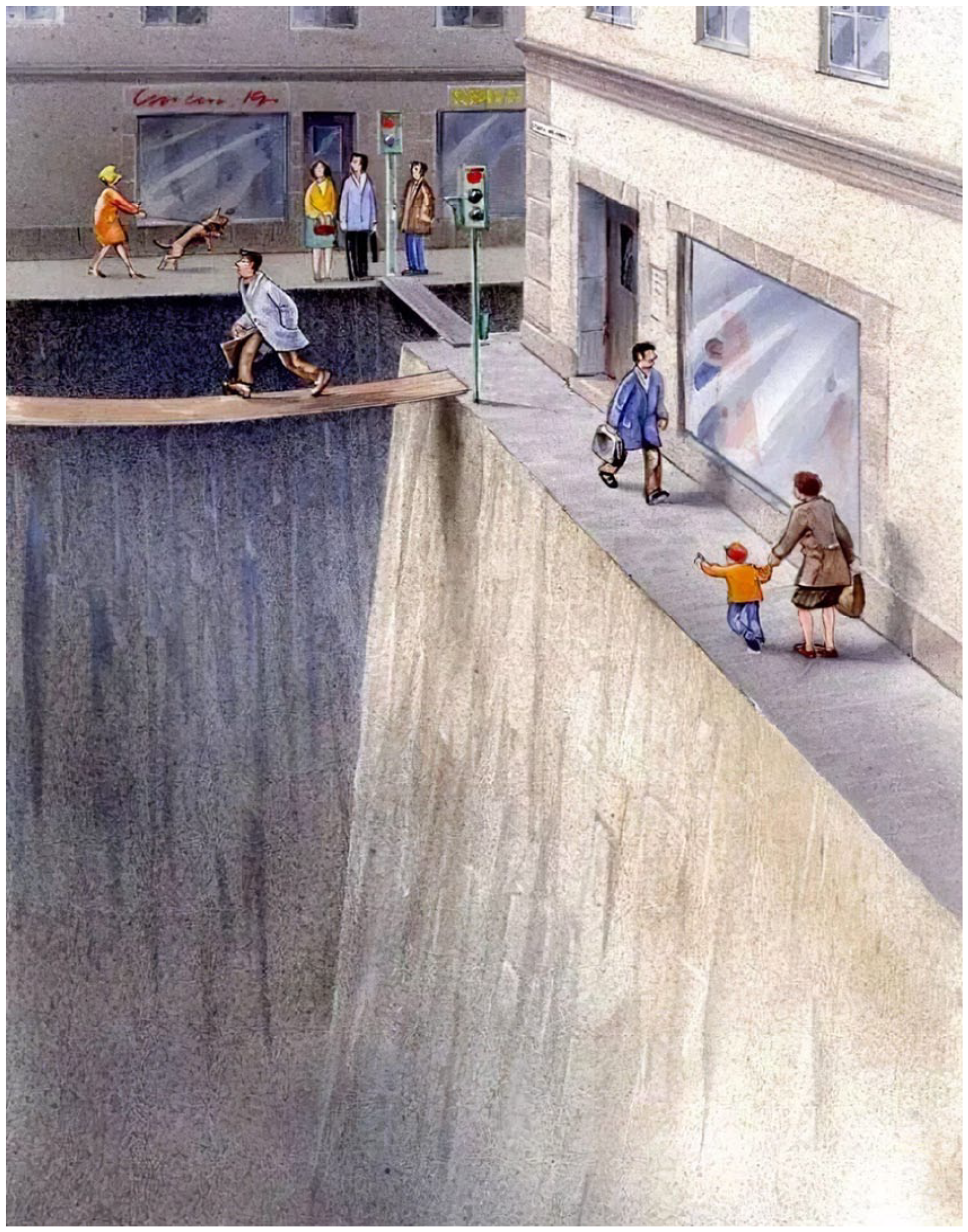
Commissioned by the Swedish Road Administration in 2014 Swedish Road Administration/Karl Jilg With Permission
In summary, there is substantial literature indicating that play is a key element in improving the design and use of urban street spaces. At the same time, there is clear research and planning knowledge regarding the benefits and the means of pedestrianizing urban streets. Many of the challenges lie in the implementation of such pedestrianized areas (Zografos et al., 2020). We now turn our attention to the implementation of the Superblock in the Barcelona context.
Barcelona’s Superblocks
While the Superblock is part of a long line of pedestrian interventions, the concept is deeply rooted in late-19th- to mid-20th-century Modernist visioning of a neighborhood or block as a “cell” of the city. When the Spanish government allowed Barcelona to expand beyond its military fortifications, it was famously planned for a progressive evolution of different land uses by Ildefons Cerdá (1815–1876) between 1855 and 1863 within a rigid grid of chamfered octagonal blocks measuring 113.3 × 113.3 m. The scheme was left open-ended to accommodate rapid shifts in taste, economic situation, and transport technology. Each block was intended to be kept undeveloped in its center or along one side so as to allow them to be aggregated into larger 226 × 226 m blocks that would be surrounded by a future tramway system (Rueda, 2020).
In his comprehensive study that formed the pillars of his proposal for expansion, Cerdá justified a theory of scientific and modern form for the city (Pallares-Barbera et al., 2011) drawing on the ideal of a scalable and egalitarian urban colony put forward by the French socialist Étienne Cabet (Epps, 2007, p. 117). He understood the essence of the viability and liveability of urban life to be an interplay between the stationary and mobility-related needs of individuals (Cerdá, 1867, pp. 408–409). These were inherent to every individual who together formed the collective needs of an urban citizenry.
Cerdá saw the home as comprising the basic elements of urban life, in the same way, that the family comprised the basic element of society. Homes clustered together formed islands or blocks (Cerdá, 1867, p. 412). Pointing to a naturalistic relationship between the home and the individuals’ bodies, he pointed to the metaphorical links between a home’s “organs,” for example, windows and balconies as eyes and ears. But in a way that was characteristically advanced and nuanced for the time (cf. Neuman, 2011), extending this to include the liberties that a house might need to make use of a surrounding “field of operations” (Cerdá, 1867, p. 412) in the same way that a body occupies space but requires an area around itself to support life. Negotiating these fields and the rights of the body-as-house lay at the heart of his proposals for the design of the interior of the urban block and the placement of the houses. These could be arranged in such a way as to ensure a guarantee of exercise and air for breathing: at the minimum the possibility to walk around the perimeter of the building as well as providing adequate, air light, and privacy (Cerdá, 1867, p. 411). As Neuman (2011) notes, Cerda’s terminology for the block was important, eschewing the colloquial term manzana (Cerdá, 1867, p. 144) and adopting the term intervía or the space between roads that included the spaces between buildings and the relationship between “buildings, public (open) spaces, and streets to each other” (Neuman, 2011, p. 125).
In contrast to the intervía, streets for recreating by “seeing and being seen” (Cerdá, 1867, p. 648) were never, in Cerdá’s opinion, destined to serve the needs of the masses, who required open vistas and the renewal of life-giving air away from homes and streets. He chamfered the corners of Barcelona’s urban blocks to create its distinctive widened street junctions (plazoletas), not to support recreation, but to improve safety and lines of sight, reduce walking distances, to free up space for commercial real estate, and to ease the turning circle of wheeled vehicles (Cerdá, 1867, p. 639, 642, 790). Apart from recognizing parks and gardens as sites for “innocent diversions” (Cerdá, 1867, p. 648), there is little in Cerdá’s theory and plan that supports pleasure, play, youth, or children.
Cerdá’s modernist vision of a strict separation of urban functions between stationary and mobility-related needs was given additional emphasis during the 20th century. The next major intervention proposed for Barcelona’s urban morphology was by Le Corbusier and Sert in 1932 (Pla Macià 1931-38). They proposed the creation of larger 400 m × 400 m blocks to facilitate the speed of automobile traffic. Antoni Bonet and Oriol Bohigas similarly proposed 3 × 3 “Superblocks” in the “Cuadernos e Arquitectura” (Bohigas, 1958) to commemorate the centenary of the Cerdà plan (Rueda Palenzuela, 2017).
The transformation of cities through Superblocks is an initiative that Rueda has been promoting since 1987. At that time, he and his team mapped urban noise levels in Barcelona. They realized that noise follows an “all or nothing” pattern. Every time a car passed, noise levels always exceeded the inadmissible daytime noise limit of 65 dBA. This realization led to a concerted effort at different levels of Barcelona’s city government to implement a neighborhood-level strategy of reducing noise to allowable levels, which entailed a reorientation of vehicular movements.
In 2019, 50% of Barcelona’s residents continue to live in conditions that exceed this noise limit. With the implementation of Superblocks, it is expected that this number will reduce to 25%. However, a further driver of the remodeling of the city is EU Law which mandates nitrous oxide levels at 40 micrograms/m3 of NO2. This can be achieved by reducing car travel by 21%. The Superblock approach was re-purposed to manage noise without compromising mobility and access. Key features of Superblocks are cells of 400 m × 400 m (3 × 3 street blocks within Barcelona’s Eixample), surrounded by a network of major routes that connect origins and destinations throughout the city. The roads inside the cells provide a local network with a speed limited to 10 km/h (Figure 2). A system of loops allows car access to every building but does not allow through-block access; vehicles must enter and exit through a single access route.
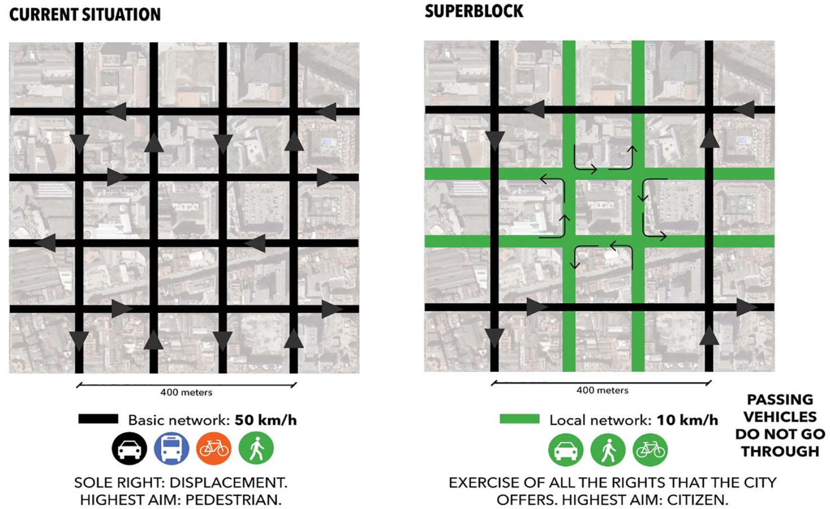
Redistributed Road Hierarchy in a Superblock Model
Indicating a link between Superblocks and antecedent Modernist planning approaches, Barcelona’s Superblock proposals have been guided by a “Charter for the ecosystemic planning of cities and metropolises” (Rueda, 2018). This document alludes to CIAM’s famous “Athens Charter” from 1933, a watershed moment in urban planning history. The Athens Charter strongly promoted the need for more “well-defined” recreation spaces that promoted the health and exercise of individuals and especially children (Congrès Internationaux d’Architecture Moderne [CIAM], 1933, pp. 35–40). But at the same time, in recognition of the need to accommodate high-speed vehicles in the centers of cities, it proposed that pedestrian and automobile routes should be fully separated.
Barcelona’s Charter takes a different direction from CIAM’s. While Barcelona’s scheme clearly utilizes ideas from the Modernist Superblock and the Neighborhood Unit, it is unique in several crucial respects (Scudellari et al., 2020). It applies its basic spatial organizing principles to existing, densely built-up, mixed-use neighborhoods rather than creating new, low-density, and single-function residential neighborhoods. It, therefore, preserves and enhances the city’s existing local social contacts and services and their accessibility, improving both social and environmental sustainability. In addition, rather than being expensive, permanent infrastructure, Barcelona’s interventions are temporary and reversible. This allows playful experimentation, evaluation, and adaptation as illustrated below in the Poblenou neighborhood.
Unlike earlier Modernist Superblocks, the dimensions of Barcelona’s are limited to the 5-min walking distance of 400 m. Its Charter calls for the percentage of public space devoted to pedestrians to be no <70% this target can be achieved with only a 15% reduction in car travel (Rueda, 2018). Barcelona’s Superblocks focus on streets as the key public spaces, rather than the Modernists’ wide-open parklands. Barcelona’s Superblocks thus promote walking everywhere, not just within isolated commercial and civic centers. Furthermore, unlike Modernist monofunctionalism, Barcelona’s Superblocks envisage the mixing of travel modes. If we want to increase the use of public spaces beyond the exclusive use for mobility, new rules that re-balance the dominance of one travel mode over another are required. This is particularly the case with cars, where at 30 km/h, out of 100 accidents five people will die. For this reason, sharing public spaces with cars necessarily involves limiting traffic speeds for cars and bicycles to 10 km/h.
While modernist planning under the Cerdá frame viewed street users as having a right to free movement, the Barcelona Superblock approach requires a rebalancing or reassignment of those rights. Rebalancing of rights is achieved by limiting speeds to those which are compatible with the use of the space by the most vulnerable people, for instance, the visually impaired or children playing. Rebalancing also means recognizing that a car travels at four to six times the speed of a pedestrian. For this reason, the Superblock is designed around the idea of a pedestrian being able to circle a block within the Superblock of 100 × 100 m taking the same time required for a car to travel around the 400 × 400 m Superblock. With these ambitious but achievable aims the following describes how play can be recruited into a process of decision-making about public space to enable the plan to be implemented.
Creating the Conditions for Play in the Superblock
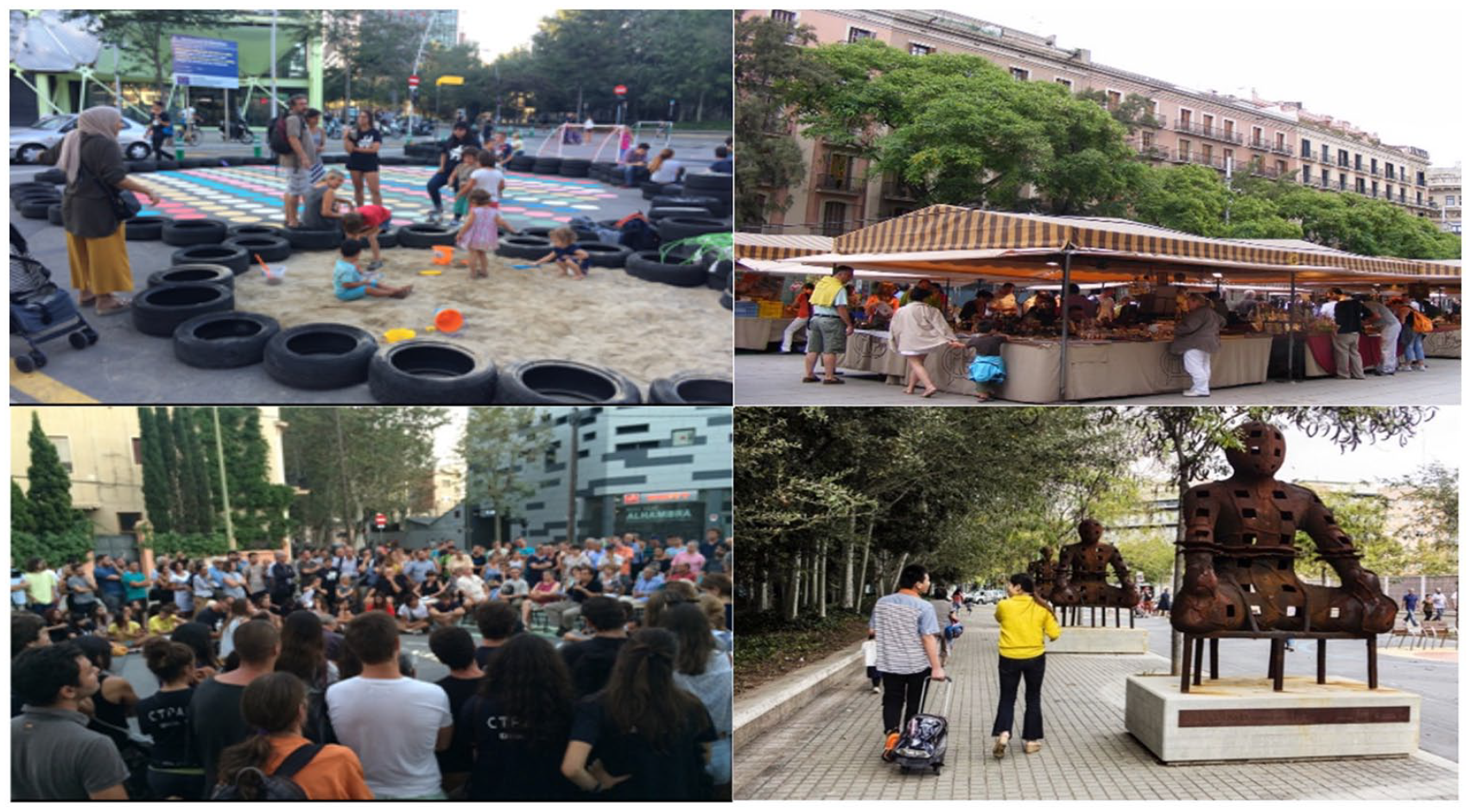
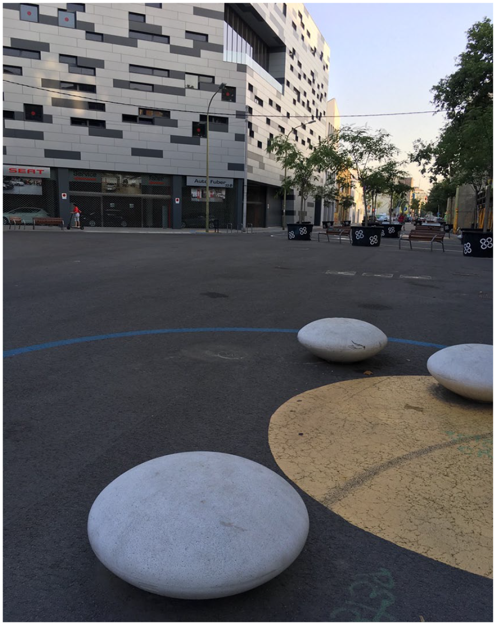
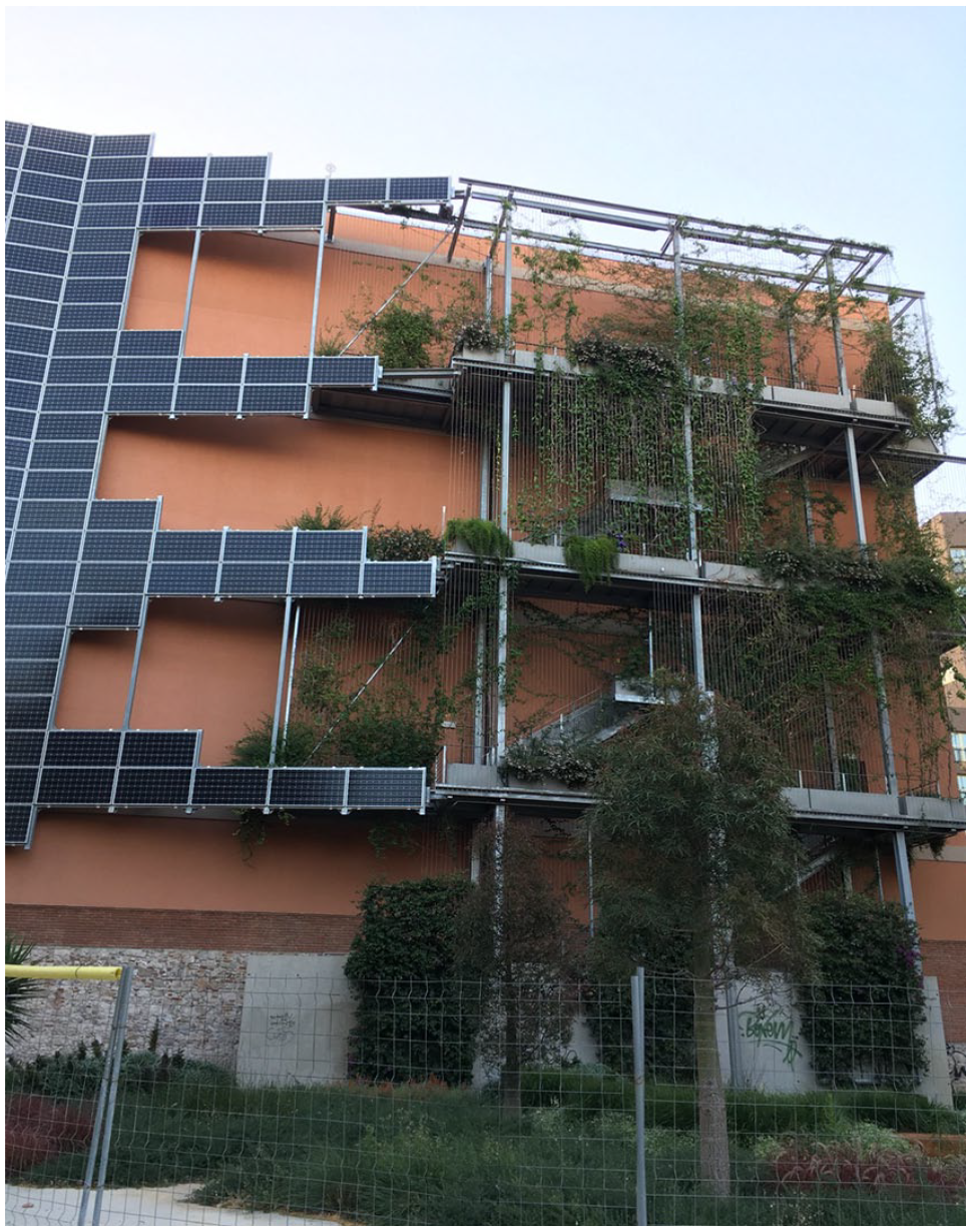
Figure 3 illustrates the implementation of the Superblock in Poblenou during the first few weeks of the pilot interventions. Three of the four images represent temporary initiatives. The image at the top left in particular shows the emblematically playful street furniture in the junctions of Superblocks, these include a sandpit constructed out of tires, trees in movable tubs, tactile objects, and painted road markings that are different from other junctions. All of these are designed to reorient the junction’s use away from that of exclusive mobility. Highlighting the temporary nature of the installation and the iterative processes used in implementing the Superblock, Figure 4 shows the transition of the same space between March 2015 and July 2019 and Figure 5 shows a nearby junction with a similarly playful arrangement of street furniture. It sits at the end of a street pedestrianized to become a running track and opposite a chamfered block wall with a fire escape repurposed as a green wall and solar panels (Figure 6).
Citizens’ Rights and Uses in Public Space: Right to Play, Right to Trade, Right to Self-Expression and Participation Right to Culture and Art

The Superblock at the corner of Carrers de Roc Boronat and Sancho de Ávila
A Seating Area at the Corner of Carrers del Almogávers and Carrers de la Ciutat de Granada
A Reinterpretation of Cerdá’s Chamfered Block Area at the Corner of Carrers del Almogávers and Carrers de la Ciutat de Granada
While the benefits of these changes are easy to understand, the dominance of any mobility for any reason as an overwhelming priority for public space is difficult to reject. An example from the team at BCNecologia serves to illustrate this. Bringing together 10 of Rueda’s team members one day they were asked to consider this scenario: a bunch of kids on exiting the school for the day decide to play a game of football in the street. During the game, a driver in a car belonging to one of the neighboring apartments wants to access the garage. What should happen next? What should the children do?
Confronted by this scenario all team members invariably replied in the same way: the kids should pick up their bags that form the goalposts, let the car pass, and then get back to the game. Rueda would ask them to consider whether the driver of the car has more rights to the space than the kids? Is mobility as such more important than play? With the aim of balancing rights to the space, would it not be more logical to allow the car to pass once there was a natural break in the play, for example, if someone scored a goal or if the ball was kicked out of play?
The important thing about the team’s response is to verify how deeply rooted mobility is in our consciousness. A consciousness that is the chief means of reproducing our current model of mobility and public space and a predeterminant that the objective of cars, which is going from one point of the city to another in the fastest way possible, is given priority.
In summary, using the improvement in air quality and a reduction in noise in the urban environment encourages greater use of public spaces and provides opportunities for play in the city. This improvement further increases when the spaces are planted, improving thermal comfort. All of these factors translate to an improvement in the urban landscape from visual, auditory, and social perspectives which together combine to become an impression of an improved urban environment. Under such conditions, streets fill with life given that the factors that prevented this have been removed.
Conclusion: Making Conceptual as well as Physical Room for Play in Planning
Cities around the world are seeking to remove automobiles from their streets, through various pedestrianization strategies that can extend to the restructuring of space and mobility across a whole city. In Barcelona’s case, the impacts of air pollution and noise on the quality of life and health provided the initial impetus for the adoption of a Superblock approach. This article has noted that Barcelona’s implementation of Superblocks was also validated by increases in the safety and the amount of public open space. These spatial improvements have in turn greatly enhanced the quality and variety of the physical and social experiences that are available in the city, expanding the playful possibilities of public life, and thus increasing mental and social as well as physical well-being.
While Modernist plans such as the Cerdá plan defined street junctions to optimize the function of vehicular movement, the Superblock envisages these as spaces for a mixture of uses, creating street space that prioritizes a range of playful pedestrian needs, which remain linked to needs for mobility. Play is included in these plans and involves recognizing that a rebalancing of citizens’ rights to urban space, vis-a-vis those of automobiles, is needed. Cerdá was highly sensitive to the rights of different citizens as individuals, as a collective, and as channeled through the built elements of cities. The Superblock, while representing a break with the past, still uses both Cerdá’s urbanism and his focus on user rights. While Cerdá’s focus was on the inside of individual blocks and courtyards, the current plan focuses attention on the junctions inside the Superblock as part of an overall strategy to reduce car-based mobility.
Through their exploratory, playful uses of Barcelona’s new Superblock spaces, residents and visitors are able to test the success and the potential of the scheme through lived experience. They define, demonstrate, and critique the possible uses and value of the expanded urban open space. This article has thus presented the play as a tool of cocreation, through which citizens are empowered to take the stage and act out what the city can be. We suggest that others cities aiming to reduce automobile dominance in their centers and to release land for pedestrians might similarly consider play as a key mechanism for facilitating public participation in the future of the city.
Superblock junctions have also been used as a site of digital development in the playful design of streets (http://superbarrio.iaac.net/, Innocent, 2020). Yet, a continuing challenge remains to not deploy such tools in planning as a one-shot surveying and participatory tool but to leverage the potential of ubiquitous computing and “ambient play” to reconfigure spaces over the longer term (Hjorth & Richardson, 2020, p. 70). The interaction between the being in the game and the doing in public space remains a key question of iterative data gathering and spatial reconfiguration for planners as they take play seriously.
This view of the playful potential of Barcelona’s Superblocks aligns with a wider body of recent research in geography, urban studies, and planning that uses play as a broad rubric for rethinking and reexamining the relationships between people, material urban spaces, and the urban planning and development processes that regulate them. That scholarship considers these relationships as open and dynamic, not determined by a single overweening, technical human need such as transport, and not even determined by the imposition of existing human values and power relations onto spaces. From this “more-than-human,” relational perspective, people’s play within material urban spaces is a form of communicative dialogue and deliberation about values and roles (Davies et al., 2012; Tornaghi & Knierbein, 2015). The play performs new relationships through people’s experimental ways of “dwelling with” urban spaces (Pyyry & Tani, 2019). People’s play constructs meaning and value for urban spaces, often in critical and oppositional ways (Bruttomesso, 2018). Citizen’s playful embodied, material, and affective engagement with urban spaces, and with their planning and management, also acts out new understandings of social concepts such as rights, participation, decision-making, and belonging.
The Barcelona example demonstrates that if people are willing to play in a space, the fundamental requirements of a space in terms of safety, accessibility, and mobility have been met. With an initial deployment of light and mobile infrastructure such as seating and markings on the ground, along with the removal of noise and pollution from cars, decision makers can easily observe the increase in pedestrians but also the emergent activities and uses that are taking place in the streets.
The iterative and playful deployment of Barcelona’s Superblocks demonstrates that play can be used as a framework to design space in an informal, contingent way. Information can be captured as users negotiate the space, challenge assumptions involved in its design, and rebalance the rights. Interactions among users, playful and otherwise, can prompt decision-makers to consider more deeply how the rights imposed onto urban space remain fluid and contingent and can constantly be renegotiated.
A playful ceding of control in the case of Barcelona’s Superblocks means that individual users are given the tools to shape their urban environment through physical action and interaction, without needing to go to the effort of learning and adopting the formal bureaucratic language of planning. Use through and in play guides and shapes space in a critical and iterative way.
Footnotes
Declaration of Conflicting Interests
The author(s) declared no potential conflicts of interest with respect to the research, authorship, and/or publication of this article.
Funding
The author(s) received no financial support for the research, authorship, and/or publication of this article.