
Abstract
Channel bars are common, striking fluvio-geomorphic depositional features of alluvial rivers. The study of this article has aimed to investigate the formation, migration, and morphodynamic alteration of channel bars (n = 50) in gravel braided alluvial rivers in Darjeeling Himalayan Piedmont zone. Dynamics of micro to meso bar deposition is mainly accomplished by the channel gradient, huge upstream landslide, and variation of discharge. Multi-criteria analysis method has been used to explain the variation of principal component analysis (PCA1, PCA2, and PCA3), both monsoon to post-monsoon. Bridge scouring, empirical aggradation, and degradation values are 0.1 to 1.05 m and
Keywords
Introduction
Running water landform processes govern the hydro-morphological amplitude1-6 and examine the calibre of water-sediment interaction towards the development of channel bar sequences as a micro-riverine unit of foothill riverbed. Such kind of unit has an ample scope for studying its formation, migration in terms of dynamism, and stability which defer with scale, dimension, sediment setting, channel gradient, variation of discharge, flow bifurcation, channel pattern, and seasonal incoming sediment, and so on.7-10 Over the past several decades, sediment transportation and regular deposition of many alluvial large rivers in the world in lower regions especially coastal areas has continuously shown a decrease.11-16 The Mississippi River (Mississippi to Gulf of Mexico, 400 MT before 1900 to 172 MT during last 3 decades) and Yangtze River (Yangtze to East China Sea, 40% decrease in 2000s) are examples for decreasing annual suspended sediment.17-20 So, the scenario of aggradation and degradation is rapidly changing.
Formation of channel bar by the processes of sediment transportation is a natural process and their morphological changes are more remarkable depending upon the channels hydrological components. 21 North Bengal rivers of Himalayan foothill region gain their ‘health’ in monsoon time and carry large amount of coarse sediment especially Teesta, Torsa, and Jaldhaka.22-24 New deposition and destruction of channel bars are much more active during July-August months of Indian subcontinent due to the interaction of varied geo-hydrological processes. But many of large, medium, and small rivers are affected by construction of dam, barrage, and bridge17,25-28 which strongly influence channel discharge, velocity, and rate of sediment transportation. In the monsoon phase, maximum flash flood zone spreads in the lower section of the bridge and as a consequence effect channel bars are formed with the flood prone large boulders. Moreover, the variations in gradient, sediment characteristics, velocity, discharge amount formulate the number, shape, and dynamicity of the channel bars of this foothill region. The increased rate of incoming sediments also brings change in the morphological characteristics and is responsible for channel bar migration.4,29-31
Among all of the previous studies, for the present research analysis, some notable works such as sediment setting of channel bars in lower Mississippi River,19,20 formation of mouth bars in Yellow River, 4 generation of gravel bars in Loire River, 32 mechanism of river mouth bar in Mossy Delta, 33 mechanism of gravel bar in Mekong River, 34 development of braided bar in Brahmaputra-Jamuna River,35-37 bar formation due to scouring process, 38 flow mechanism and numerical modelling of channel bars,8,39-43 evolution of large bars in Jamuna River, 44 point bar deposition in Peace River, 45 and significance of mid-channel bar in Dane River are considered. 46 This study has focused on the dynamic nature of channel bars in Darjeeling Himalayan piedmont zone. The study has also included migration rate of 50 channel bars since 2000s on the basis of different intensive field visits and with the aid of different empirical equations with geo-statistics techniques. This is a novel research which has monitored the stability and instability of channel bars and is very vital for planners, environmentalists, agriculture and forest department, authority of environmental management, and different river institutions.
Study Sites, Geology, and Tectonic Setup
This study has been done in the piedmont section of the Eastern Himalayas drained Lish, Gish, Chel, Mal, Neora, Murti, Juranti and Jaldhaka, Teesta, and Torsa rivers (Figure 1). All these rivers are a part of the Ganga-Brahmaputra subsystem and are much younger in age as they are present in the piedmont zone of the Himalayas.47,48 All these rivers originate at a very high elevation of above 1500 to 2000 m and end jointly at around 50 to 300 m elevation. Considering the geomorphological and hydrological disparity, the piedmont area of Darjeeling Himalayas has been classified into 3 specific zones: Upper (>150 m), Middle (150-100 m), and Lower (<100 m) (Figure 2; Table 1). The rivers, which are considered in this study, have the major orientation from NE to SW, all with prominent seasonal variation. These tributaries are mainly non-perennial excepting large rivers such as Teesta, Torsa, and Jaldhaka. These non-perennial streams form small alluvial fans at their debouching points and contain numerous minor faults along their courses which are active in nature.49-52 As these rivers are mainly dependent on seasonal rainfall, the distribution of the boulders is also controlled by the rainfall intensity and pattern. The region is mainly covered by the young quaternary sediments which are the most recent deposition. However, exposures of Gondwana group of rocks are noticed along the sections of Gish Nadi and Ramthi Nala. Prominent quartzite bands are visible in several rocks of this region. The tectonic setup of the region indicates that the region is tectonically very active. Being a part of the Himalayan Foreland Basin, it contains the most active fault, that is, the Main Frontal Thrust. 48 This fault line passes through the course of these rivers which is one of the reasons for the development of several minor faults in the course of these rivers,49-51 and at many places, the channels take straight and right-angle bends. The foreland basin is characterised by axial and traverse drainage patterns. 53 The deposition from the rivers of the foreland basin controls the dynamics of the basin since the Pleistocene. The presence of numerous fluvial mega fans 53 and many small mountains attached micro fans is the main characteristics of the Eastern Himalayan mountain front. Gish River to the Neora River is an indicator of the neo-tectonic activities that had taken place here. Two groups of faults are noticed here, namely, the east-west trending faults along the mountain fronts and the NNE-SSW to NNW-SSE trending faults along with the river courses such as Gish, Lish, Chel, and Lethi rivers.

(A) Major basin and sub-basins in Indian subcontinent with change of elevation; yellow box indicates area of this study. (B) River system and subsystem of Darjeeling Himalayan foothill zone; Teesta, Lish, Gish, Chel, Mal, Murti, Kurti, Naora, Jaldhaka, Daina, Torsa are selected for sample size.
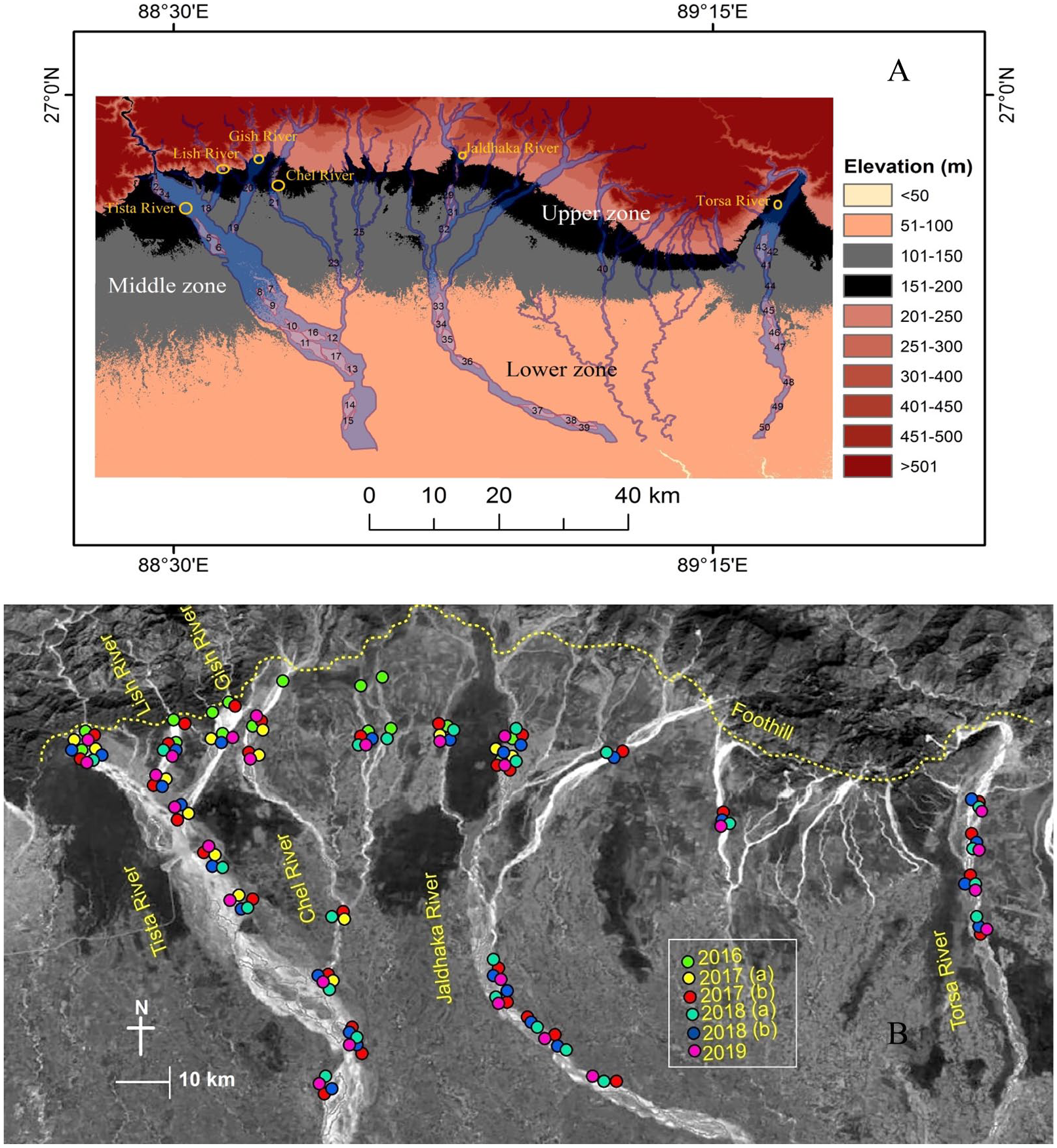
(A) Major 3 zones for analysis of morphodynamic alteration of channel bars in Darjeeling Himalayan foothill zone; Upper zone (>150 m), Middle zone (100-150 m), and Lower zone (<100 m). (B) Different field surveys are conducted during the work since 2016 on the basis of above zonation.
Location and geomorphic characteristics of the sample sites of channel bar of some major rivers such as Teesta, Torsa, Jaldhaka, and their prime tributaries in Darjeeling Himalayan foothill zone.

Data and Methods
The whole study was developed in 3 individual stages: primary data, secondary data, and geospatial technique. Primary data survey was conducted for the past 4 years (2015-2019) especially during the beginning of the winter season, end of the winter season, and monsoon season. Secondary data were collected from the Survey of India (Kolkata) for Topographical map and Landsat images were downloaded (Landsat 8) from USGS Earth Explorer.
MCA models
For understanding the dynamic nature of the formation of the bar in piedmont region, multi-criteria analysis has been applied,54-56 Principal component analysis method (PCA) is used for proper clarification. Geo-hydrological components such as bed slope, water discharge, gradient, bed elevation, velocity, roughness, specific stream power, and shear stress have considered as parameters for this analysis. Some of the geo-hydraulic equations are supported for the explanation of PCA consistencies. Those are ‘Cross-sectional area (A) = W × D’, Water Discharge (Q) = A × V, Wetted Perimeter (WP) = W + D, Hydraulic Radius (HR) = A/WP, Mean Shear Stress
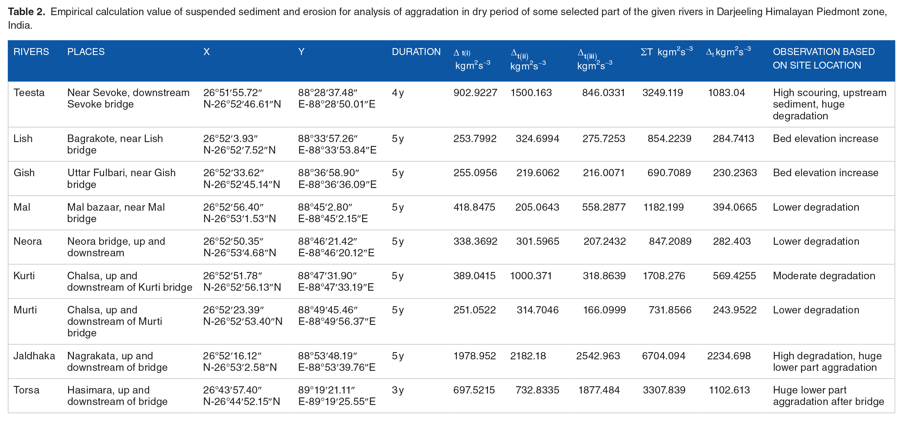
Rate of erosion and bar aggradations
Rate of erosion in upstream and downstream of the bridge indicates the major zone of agglomeration. For this purpose, one hydrodynamic mathematical equation is employed for the outcome of the results for bed erosion with suspended load relation. 58
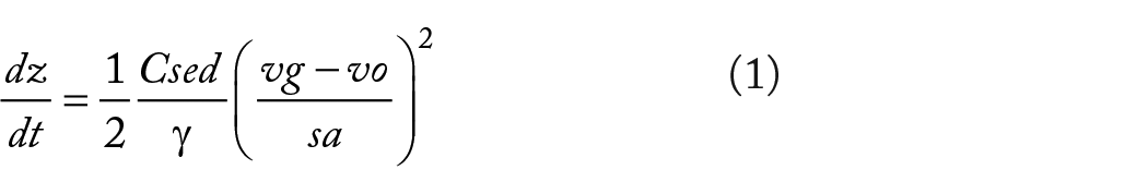
where ‘dz’ erosion rate, ‘dt’ is time, so ‘dz/dt’ is the rate of bed erosion due to time duration; ‘Csed’ is river bedload sediment;
Analysis of bridge scouring address in different points
Richardson’s scouring equation 59 is applied for the analysis of the rate of erosion in different bridge points at the beginning of winter and end of the winter season since 2015. This equation is directly related to bridge scouring condition of this place which is a better observation of aggradations and degradation. The equation is as follows:

where
Interpolation and union methods
We have classified the dynamicity of bar size, width, and length into 5 general categories by the following traditional statistical class boundary methods (C = 1 + 3.322logN, 6.44). On the basis of variation of dynamicity, real figure of data and the field verification, 5 classes have been chosen for better explanation. Classes of channel bar with longest width dynamicity are <0.25, 0.25 to 0.50, 0.50 to 0.75, 0.75 to 1.00, and >1.00 km. The dynamicity of channel bar size classes are <0.25, 0.25 to 0.50, 0.50 to 0.75, 0.75 to 1.00, and >1.00 km². The method of interpolation and union has helped to analyse the stability of the mid-channel bars in respective sites. With the help of interpolation method, it was possible to identify the effective bar development areas which also include the areas where the maximum deposition of bars has taken place. The method of union could depict the common areas from the interpolation data where there is constant bar formation since the 2000s. These are very effective methods which are very helpful to understand the changing zones of bar formation, development of new zones, stable zones with continuous deposition, and also the zones which show degradation. These methods were applied with the help of ArcGIS 10.2.2 for getting the result of the net stable area and also the whole bar genesis region.
Geospatial techniques
Some of the importantly supported mappings are done by geospatial techniques in different software such as ArcGIS 10.2.2, Global Mapper 18, and Surfer 11. A basic morphometric technique like the change of surface elevation and slope aspect is developed by IDW method and Raster Interpolation methodology in ArcGIS 10.2.2. Total Station [FOIF (EL302A)], hand GPS (Garmin eTrex, VISTA HCX, horizontal ground accuracy ± 3 m), and clinometers are used in the winter season where bar surface is dry and open also. Cross-profile of different bars is prepared by Global Mapper 18 with the help of riverbed DEM (Digital Elevation Model) of Total Station [FOIF (EL302A)] and hand GPS (Garmin eTrex, VISTA HCX, horizontal ground accuracy ± 3 m) data. Riverbed and bars DEM are also made by Surfer 11 with the help of TS data.
Results
Hydro-geomorphic integrity
Hydro-geomorphic component variation of Darjeeling Himalayan piedmont rivers is very dynamic in pre-monsoon to post-monsoon.
12
After the rainfall, mountain rivers are very energetic in the Eastern Himalayan region. In the rainy season, the amount of rainfall is 100 mm approximately per day in this region.
60
The mean discharge of Teesta, Lish, and Gish is

MCA (multi criteria analysis) of different components on hydro-geomorphological integration in channel bar dynamicity, in the left figure indicated MCA of Teesta, Lish, Gish, Chel, Mal, Naora, Murti and Kurti (2016-2018) right figure indicated MCA of Jaldhaka, Daina and Torsa (2017-2019).
Riverbed erosion and aggradation process
Alluvial rivers in the Himalayan foothill region are very dynamic,47,48,62 especially in terms of deposition.
10
The mobile deposition is a common feature of the riverbed in Darjeeling Himalayan foothill zone. Many times, seasonal deposition of the past is eroded by the huge amount of water mass and seasonal flood. River curvature such as meandering, sinuosity, and anabranching have high influence on the temporal deposition of the channel. A better explanation of aggradation and degradation in different points of the riverbed is explained by bed erosion with suspended load relation which is widely developed by Foley
58
and Dhali and Sahana.
21
The value of this hydrodynamic empirical equation since 2015, in the dry season of Teesta near Sevoke, Lish near Bagrakote, Gish near Uttar Fulbari, Chel near Odlabari, Mal near Mal bazaar, Neora near Neora bridge, Kurti near Chalsa, Jaldhaka near Nagrakata, Torsa near Hasimara varies from
Empirical calculation value of suspended sediment and erosion for analysis of aggradation in dry period of some selected part of the given rivers in Darjeeling Himalayan Piedmont zone, India.
Bridge scouring and channel bar deposition
In this study, it has been witnessed that the scouring processes have significant extent and the result of Richardson’s scouring equation has prominently delineated the changes of velocity with depth in accordance with the process. The depth of bridge scouring of Teesta, Torsa, and Jaldhaka are 1.05, 0.55, and 0.64 m at Sevoke, Hasimara, and Nagrakata. Others tributaries such as Lish, Gish, Mal, Murti, Kurti, Neora, Chel, Dhorla show 0.10 to 0.40 m scouring depth (Figure 4). The values of scouring along the studied channel also depict the alternative change of sediment regime which is strongly interrelated with the stream energy and velocity distribution. The observed mean D50 value shows an alteration regime of bedload distribution near the bridge. 10 The empirical equation values in Teesta, Torsa, and Jaldhaka provided 8.2585, 9.6272, and 7.1317 which depicts the high degradation behaviour. The empirical values of River Chel near road and railway bridge show 5.388 and 4.3017 where real scouring depth are 0.82 and 1.06 m (2015-2019). The hydrological parameter and sediment mean D50 values, both are responsible for the changing nature of the regime which has become a cause of huge deposition just after the bridge and sudden release of energy, aggravate the depositional rate with the resulted landform. Some of riverbed cross sections have also provided a change of bar surface and active channel depth. In the upper part of the bridge in Jaldhaka River; AB, CD, and EF are riverbed cross sections. AB provided 174 to 178 m surface elevation, CD is 169 to 166 m, and EF is 168 to 162 m. The elevation drop moves an active channel from those places. PQ, RS, and XY are other riverbed cross sections in the lower part of the bridge. PQ highest and lowest surface elevation is 155 to 145 m, RS is 155 to 145 m, and XY is 150 to 135 m (Figure 5). River bars are affected by some of the anthropogenic activities such as bridge construction and seasonally boulder, pebble, and cobble lifting of the riverbed. Lifting of the large size sediment on the riverbed has also decreased the bar elevation, and in some points, bar mean angle with the related mean direction of the active channel has also migrated.

Scouring depth of different bridges (I – railway and II – road) in the month of post-monsoon phase, Darjeeling Himalayan piedmont region.

(i) Configaration of channel bar in Nagrakata bridge upper part, Jaldhaka River. AB, CD, and EF are respective elevation profiles which indicate bar surface morphology in different sections. (ii) Channel bar morphology in lower part of the bridge. PQ, RS, and XY are the major cross sections of bar surface elevation. Blue arrow indicates the present active channels.
Configuration of bar morphological attributes
From the upper, middle, and lower zones of piedmont areas, 10, 19, and 21 channel bars have been selected, respectively, for the study. Different types of channel bars have observed in this foothill region (Figure 6). These 50 mid-channel bars are of large, medium, and small size. For configuration of bar morphological attributes, 18% (>3 km2), 44% (>1.5 km2), and 38% (<1.5 km2) are of large, medium, and small size. All these bars covered 20% (n = 10), 38% (n = 19), and 42% (n = 21) of the total bars of the respective zones. The orientation of the bars direction changes from north to south, south to west, and south to east in response to the river flow direction. The relative height of the bar varies from 5.1 to 0.2 m, 5.1 to 0.1 m, and 2.2 to 0.6 m respectively in the different altitudinal zones. The nearest bar active channel water depth of dry season covered 2.6 to 0.1 m, 1.8 to 0.1 m, and 2.6 to 1.1 m.

Various types of channel bars in Darjeeling Himalaya foothill zone: (A) mid-channel bar in Jaldhaka River near Nagrakata bridge, (B) side channel bar in Torsa River near Hasimara road bridge, (C) sand bar in Teesta River near Maynaguri, (D) stable channel bar in the lower part of Torsa River, and (E) Gravel channel bar in Teesta River near Sevoke.
Reach-wise variation in longest length of channel bars
Mean active channel flow is continuously dynamic
63
because the braided nature and channel bars have shifted from their original position in the past 20 years. From the field observation, unstable bars are affected by active flow orientation of the sites. Multiple channel pattern and change of sediment deposition in mid- to side-channel are quite changed by the nature of flow.
47
Mean bar directions are south-south east (SSE) to south-south west (SSW) from true north and mean flow direction is south-south east (SSE). Mid-channel bars and related active channel flow are quite shifted towards leftbank from the source of the river. The important fact is that the coefficient of determination between the shifting of bars and active channels has a very strong positive relation
Dynamic behaviour of decadal change of channel bars’ longest width in the upper, middle, and lower part of piedmont zone.

Stability analysis of mid-channel bars
Development of channel bar is a continuous process in the Darjeeling Himalayan piedmont area. Riverbed deposition character depends on the seasonal deposition of sediment. 10 Flash flood is the usual phenomena of fluvial flood hydrology of North Bengal. Many of Eastern Himalayan foothill rivers such as Lish, Gish, Lethi, Murti, Kurti, Lethi, Jaldhaka, Teesta, Torsa, and Gish are affected by this type of phenomena. Seasonal flash floods, the huge amount of discharge (monsoon), the variation of incoming sediment have a formidable impact over the channel bars’ growth. In the middle zone of piedmont area, the nature of area migration for 15.79% is very high (>1 km2), 5.26% has high (0.75-1 km2), 21.05% has moderate (0.50–0.75 km2), 42.11% has low (0.25–0.50 km2), and 15.79% has very low (<0.25 km2). In the lower zone, 47.62% of area is under very high dynamicity, 14.29% is of moderate, 28.57% is of low, and 9.52% is of very low in nature (Table 4). Some of the bars are seasonally destroyed, some get migrated, and some new ones need to be accommodated. Channel bars 5, 9, 11, 13, 14, 16, 17, 33, 38, 43, 45, and 46 continuously show their dynamic nature which is basically under the lower and middle area of piedmont region (Figure 7). It is seen that in the upper zone of the piedmont area, since the 2000s, 58% to 72% channel bar area are stable. But in the middle and lower zones of the piedmont region, 26% to 42% and 14% to 29% area of the total channel bars is stable respectively (Figure 8).
Dynamic behaviour of decadal change of channel bar area in the upper, middle, and lower part of piedmont zone.


Migration of channel bars since 2000 in Darjeeling Himalayan foothills zone: (A) Teesta River near Sevoke, (B) Teesta River near Kranti, (C) Teesta River near Hanskhali, (D) Teesta River near Maynaguri, (E) Chel River near Odlabari, (F) Jaldhaka River near Nagrakata, (G) Jaldhaka River near Panbari, (H) Jaldhaka River near Dhupguri-Falakata, (I) Torsa River near Hasimara, (J) Torsa River near Mathurabagan, and (K) Torsa River near Madarihat.

Site-wise channel bar stability in Darjeeling Himalayan foothill zone: (A) Teesta, Lish, Gish, and Chel River (Sevoke, Hanskhali, Odlabari); (B) Teesta River near Kranti; (C) Torsa River near Madarihat; (D) Teesta River near Maynaguri; (E) Jaldhaka River near Dhupguri-Falakata; (F) Jaldhaka near Nagrakata; (G) Torsa River near Hasimara; (H) Total study area of Darjeeling Himalayan foothill region.
Discussion
The considered area is a prominent state of the alluvial channel having a distinct aggradation process resulting in the formation of channel bar. Concerning the above-described methodology and after results analysis, it has been found that alteration of channel bar formation is a result of changing behaviour of the geo-hydrological processes and the effect of human interaction such as the construction of bridges, roads across the channel. Following the model of MCA PCA1, PCA2, and PCA3 for the rivers Teesta, Lish, Gish, Chel, Mal, Neora, Kurti, and Murti is scored as 86.67%, 53.33%, and 66.67%, respectively. Some observations have also been noticed in case of rivers Jaldhaka, Daina, and Torsa where the values of PCA1, PCA2, and PCA3 are 93.33%, PCA2 is 53.33% and PCA3 is 53.33%. The major concerned hydraulic components are water velocity, mean width, mean depth, wetted perimeter, hydraulic radius, cross-sectional area, water discharge, stream power, bed slope, inertial force, water depth (active), shear stress, and specific stream power. All these variables have been irregular from season to season. The comparison of erosion and deposition in respect of roughness also shows a distinct difference between upper and lower zones which depicts that within 1 year, bed roughness has been modified in the lower zone. The spatial pattern of stream power helps to make a clear concept of monsoon character. The huge variations of water discharge with enormous energy are resulting in huge sediment deposition along the channel.
Two empirical methods have been applied for the analysis of aggradations along the channel. Mobile depositions are analysed by empirical values of Foley
58
and Richardson.
59
The rivers Jaldhaka at Nagrakata, Teesta at Sevoke, and Torsa at Hasimara show high Foley values such as
The morphological study of the riverbed may speak about the general physical display of relief and slope bed and shows the prominent spatial variation of channel bars along the riverbed. The focused area has a huge vertical drop within short horizontal distance, from the downstream of the bridge where the reshaping of the bars is a continuous process. There is a prominent difference in height of bars between the upper and lower zones. The vertical height of upper, middle, and lower zones of respective channel bars are 5.1 to 0.2 m, 5.2 to 0.1 m, and 2.2 to 0.1 m. But the mean vertical elevations are 2.4, 1.8, and 0.9 m. The channel bar of the upper zone is stable concerning middle lower zone. Seasonal flash flood of the middle and lower zones of bars has changed the stability of bar nature. The bed elevation shows increase in Chel, Lish, and Gish which is the controlling factor of flow avulsion. Comparing the lower part of the bridge, if we analyse the cross section, there is a remarkable bifurcation of channels including active channels, seasonally active channels, and so on. Maximum flow avulsion is observed in the lower and middle zones of the piedmont area.
Size and longest length of the channel bars are very dynamic; in the upper zone, many of bars are stable since the 2000s because avulsion rate is low with respect to other positions. Change of bars area and its longest width have positive relation (R² = .627) (Figure 9). Here, in the upper zone stream power, velocity and discharge are high but the rate of deposition is very low. The nature of dynamicity in the area of the channel bars in the upper zone is 0.12 to 0.71 km2 which is very low but the bars 20, 22, and 29 show moderate dynamic nature. In the middle and lower zones of the piedmont area, channel bars have very high dynamicity in their size, shape, and length. In the middle and lower zones, the rate of alteration in area is 0.12 to 2.83 km2 and 0.1 to 5.43 km2 repectively (Figure 10). Huge changes of velocity, granulometric character of sediment, change of channel gradient, and upstream landslide are major considering factors for this dynamicity. Sometimes large bars are divided into some fragmented-part by the seasonal active channel and also a single bar may form by joining with many smallar one. So, the morphodynamic alteration is frequently observed in the lower-middle zone where the accommodation and destruction processes of channel bars are found.
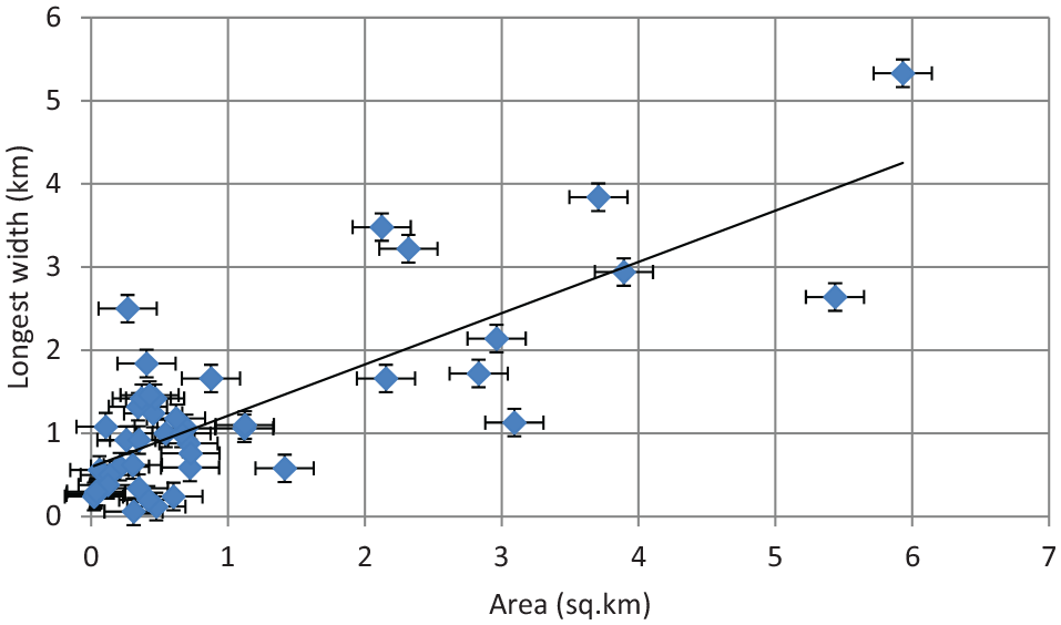
Correlation between channel bar area and longest width of selective 50 channel bars.

Channel bars’ dynamicity of selective 50 bars: (A) size aspect and (B) longest width aspect in Darjeeling Himalayan piedmont zone.
Conclusions
This research reports on formation, migration, and morphodynamic alteration of 50 channel bars in Darjeeling Himalayan piedmont zone. The rivers in the foothills of Darjeeling Himalayas in the northern part of the state of West Bengal are flowing over a region of active tectonic activities. This has resulted in the formation of extraordinary features on the bed of the rivers and the development of meso and micro channel bars. The original outcome of the research is the result of several field verifications and primary to the secondary database. The quantitative data set provided major bars are dynamic nature in a life period due to their huge change of hydro-geomorphic behaviour. The change of fluvial hydraulics, spatial variation of aggradation, and degradation are responses over this dynamic nature. Spatially, the huge amount of seasonal cohesive sediment and variation in discharge bring changes in the channel bars’ size, shape, and stability in response to the variation of altitude and gradient from the foothill to the lower reach of the channels. The natural factors have initiated the formation but anthropogenic factors have aggravated the situation and sometimes even lead to a misbalance in the natural regime. The constructions of the bridges across the river have changed the configuration of channel bars due to their changing flow pattern. From the investigation, it has also been depicted that bridges have stronger influence on the morphology of the bars as compared with the sediment influx by monsoonal rainfall. Rate of degradation and aggradation of the channel has been exaggerated by the presence of bridges. This could be a major reason for the dynamic activity of the bars in the middle and lower zones where bridges are present. As per the environmental concentration, piedmont stable channel bars are useful for settlement habitations, seasonal agriculture, and social forestry. The gravel, sand, and heterogeneous sediment of unstable channel bars are also helpful for building construction purpose. The local government, authority of environmental management, and river institutions should pay prime attention on these considered piedmont channel bars for sustainable river management plan.
Footnotes
Acknowledgements
We convey our special thanks to USGS Earth Explorer, ArcGIS 10.2.2 software, IBM SPSS 22 software, and Google Earth application providing some data and supporting for creation of maps. We are also thankful to the Editor-in-Chief Erick R. Bandala (Water section), Commissioning Editor Bree Sundling and the anonymous reviewers for their valuable comments to substantial improvement of the manuscript.
Funding:
The author(s) received no financial support for the research, authorship, and/or publication of this article.
Declaration of conflicting interests:
The author(s) declared no potential conflicts of interest with respect to the research, authorship, and/or publication of this article.
Author Contributions
First author as a research scholar has done this research work under the supervision of second author, all authors have made equal efforts for construction of this manuscript.