
Abstract
Rapid urbanization and multiple deprivation are making cities more prone to numerous disasters. This study examines the relationships between disaster risk perception and multiple deprivation in the Rangpur city Corporation area in Bangladesh. Enhanced understanding of this relationship would bring valuable insights for planning and policies, especially pertinent for vulnerable communities in the Global South. Rangpur city is located in a deprived zone of Bangladesh that is highly prone to earthquake and fire hazards, and the population’s low level of risk perception might exasperate their vulnerability to earthquakes and fire. This study’s research methods include an index of multiple deprivation, earthquake and fire risk perception index, geographic information system (GIS)-based mapping, statistical analysis and questionnaire surveys. The statistical methods are correlation analysis, factor analysis, Kaiser–Meyer–Olkin test and cross-table analysis. The results of the study show that there is no statistically significant relationship between disaster risk perception and multiple deprivation; however, cross-table analysis revealed a relationship between risk perception and deprivation. The study identified the hot spots of hazard risks and deprivation in Rangpur city. To the best of our knowledge, this is the first effort to investigate the relationship between disaster risk perception and multiple deprivation.
Keywords
Background and Justification
The concept of risk perception of hazards is associated with perceived personal risk and hazard experience, information, adjustment and proximity (Lindell & Hwang, 2008). Moreover, an individual’s personality, the type and the context of risk, culture and the social context influence the risk perception (Appleby-Arnold et al., 2018; Wachinger et al., 2013). The combination of deficiency of food and clothing, poor living conditions and not attending basic education is referred to as multiple deprivation (Yuan et al., 2018). Furthermore, an individual’s personality, culture and social context could be influenced by multiple deprivation.
Understanding people’s risk perception and the determining factors is essential for improving risk communications, management decisions and designing effective mitigation policies (Ardaya et al., 2017; Atun, 2021; Atun, 2014; Ho et al., 2008). At the same time, the interconnectedness of population growth and multiple hazards was recognized by the international community and adopted in the Sustainable Development Goals (SDG Goal 11b) and the Sendai Framework for Disaster Risk Reduction (DRR) in 2015 (UNHQ, 2015).
Many researchers have worked on social vulnerability, disaster risk and disaster management in the context of Bangladesh (see Ahsan & Warner, 2014; Alam & Bhadra, 2019; Barua et al., 2016; Brouwer et al., 2007; Gray & Mueller, 2012; Karim, 1995; Rabby et al., 2019; Uddin et al., 2019). The topics of earthquake risk perception (ERP) and fire risk perception (FRP) in Bangladesh have been prominently studied (see Islam & Adri, 2008; Ministry of Disaster Management and Relief, 2015; Paul & Bhuiyan, 2010; Rahman et al., 2015). Islam and Adri (2008) explored the fire hazard vulnerability of Dhaka city, focusing on the city’s fire hazard management strategy, formulated based on the institutional capacity and public perception. Paul and Bhuiyan (2010) examined ERP and preparedness of the inhabitants of Dhaka city. The Ministry of Disaster Management and Relief (2015) has published an Atlas on seismic risk assessment of six cities (i.e., Bogura, Dinajpur, Mymensingh, Rajshahi, Rangpur and Tangail). The Atlas assists local government, policy makers, planners, researchers, house owners and developers to understand the vulnerabilities of potential earthquake hazards, with the aim of building disaster-resilient cities. Rahman et al. (2015) assessed the vulnerability of the old part of Dhaka city to fire and earthquake hazards.
However, no study has yet examined disaster risk perception or multiple deprivation in Rangpur city, and moreover, no study has tried to uncover their interconnection. This study’s research methods include an index of multiple deprivation (IMD), ERP and FRP index, geographic information system (GIS)-based mapping, statistical analysis and questionnaire surveys. The statistical methods such as correlation analysis, factor analysis, Kaiser–Meyer–Olkin (KMO) test and cross-table analysis were carried out for investigating the relationship. The insight from this relationship could support DRR and deprivation-related planning and policies in Rangpur and across many Global South cities with similar socio-economic and urban settings.
Research Question and the Local Context
The main research question of this study is formulated as follows: How does disaster risk perception change with multiple deprivation? To answer the research question, we selected 15 electoral wards (EWs) of Rangpur City Corporation (RpCC) as the study area. Rangpur city is located in the lowest income zone (Bangladesh Bureau of Statistics [BBS], 2019), one of the most deprived areas since independence. Apart from multiple deprivation, Rangpur city is vulnerable to earthquakes and fire hazards. It is located within earthquake zones 1 and 2 (Ali, 1998; Paul & Bhuiyan, 2010) and has been in the epicentre of major earthquakes (Ali, 1998). In recent years, Bangladesh has experienced a few tremors (Paul & Bhuiyan, 2010; Rahman et al., 2015), which luckily were not severe; however, the increasing population could face devastating consequences under a magnitude of six or seven earthquakes (Ali, 1998).
According to government statistics for the 2004–2018 period, 1,970 people died in fires, with economic losses upwards of USD 66 million. In that same time, Rangpur Division reported 16,568 fire incidents (Bangladesh Fire Service and Civil Defence, 2019). As already mentioned, the population of RpCC is growing rapidly, with associated increase in risk of mass fatalities due to large-scale fire accident or earthquakes.
Brief Description of the Study Area
Rangpur city emerged as the headquarter of the Mughal administration in Sircar Cooch Behar in the eighteenth century (Vas, 1911, p.2). Afterwards, the former Rangpur municipality (the local term is ‘Paurashava’) was upgraded to a city corporation 1 in 2012 (LGED, 2014). At present, RpCC governs 33 EWs, spanning 205 km 2 . Fifteen EWs were selected as the study area, which was under jurisdiction of former Rangpur municipality (Figure 1).
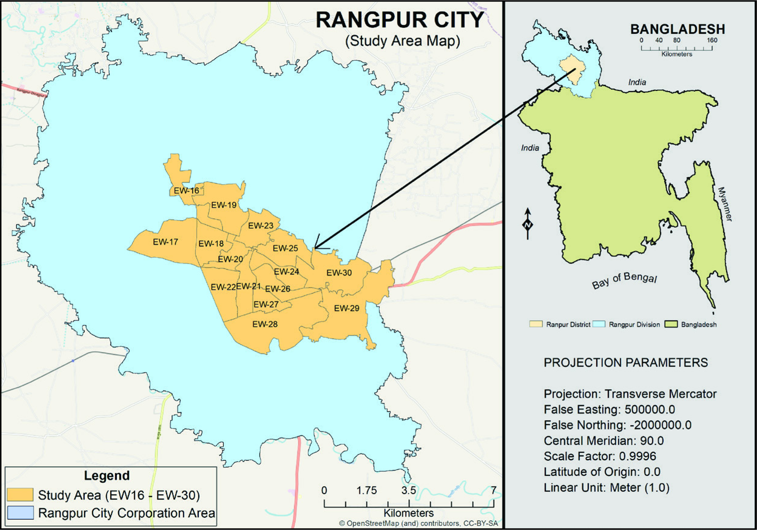
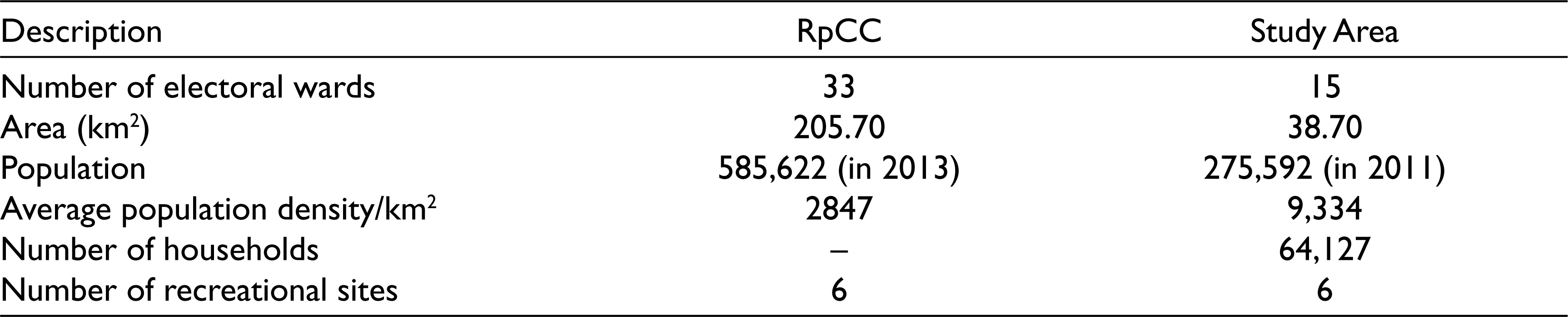
Table 1 gives a brief description of RpCC and the study area (EW16–EW30). Notably, the study area has three times the population density of the city average (BBS, 2013; LGED, 2014) and hosts most of its economic- and business-oriented activities. As a result, these wards are considerably less deprived than the other 18 (which previously were rural). That was also a good reason to select EW16–EW30 as the study area. Otherwise, it could lead us to selection bias regarding the multiple deprivation analysis. Although the study area does not cover the entire city corporation, we will use ‘Rangpur city’ to refer to the study area in the rest of this article, because it represents the city’s urban core.
Brief Description of RpCC and the Study Area
Data and Methods
Data and Sources
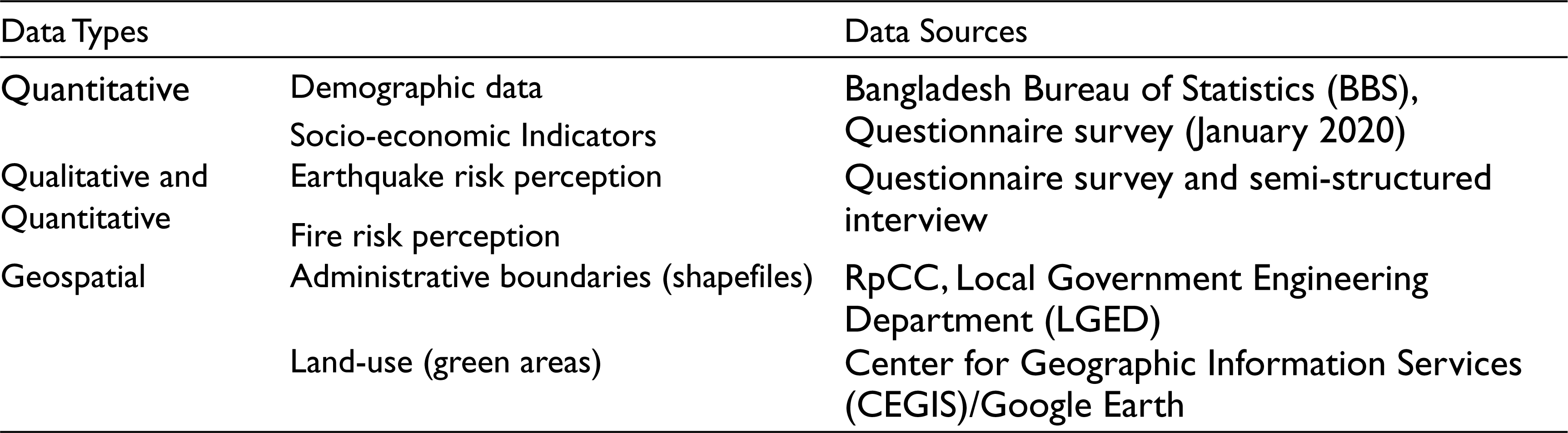
Three types of data were used for this study (see Table 2). First, quantitative data included demographic (population, density, age, etc.) and socio-economic data (literacy rate, employment rate, dependency rate, household type, ethnicity, sanitation, etc.), as indicators of multiple deprivation. These data were collected from the official website of the Bangladesh Bureau of Statistics (BBS). Second, for ERP and FRP, data were collected directly in the field through a questionnaire survey. Finally, different shape files and land-use data were collected and extracted from the Rangpur City Masterplan, the RpCC website and the Centre for Environmental and Geographic Information Services (CEGIS).
Required Data and Their Sources
Sampling Methods for Field Data Collection
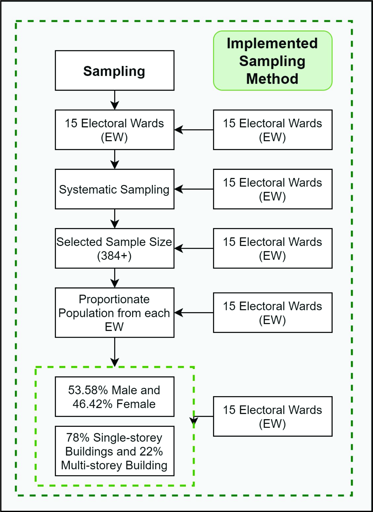
The study area’s total population was obtained from the national statistics of 2011 (BBS, 2013). The total sample size was determined (384 respondents), at a significance level of 95%, with a confidence interval of 5, where the confidence interval helped to define the boundary for the presentable population size (Field, 2018). Afterwards, the proportionate stratified sampling method (Kumar, 2011) was applied to determine the sample size for each EW; however, it was not always possible to maintain the exact sample number for each EW. Furthermore, the ‘non-random-quota’ method (Kumar, 2011) was applied to ensure the equal male–female participant ratio. It was not possible to maintain an equal balance of single-storey and multi-storey households, because multi-storey households proved less accessible by surveyors, due to the respondents’ security concerns. Figure 2 illustrates the sampling methods.
Questionnaire design and survey
The questionnaire was designed using KoBoToolbox (
Data analysis And Visualization
Calculating Earthquake Risk Perception
A risk perception index (RPI; Equation [1]) was used based on eight questions (see Appendix A) that measured individual perception of earthquake risks. The statements were adapted based on prior efforts (Kung & Chen, 2012; Paul & Bhuiyan, 2010; Shrestha et al., 2018; Rahman et al., 2021).
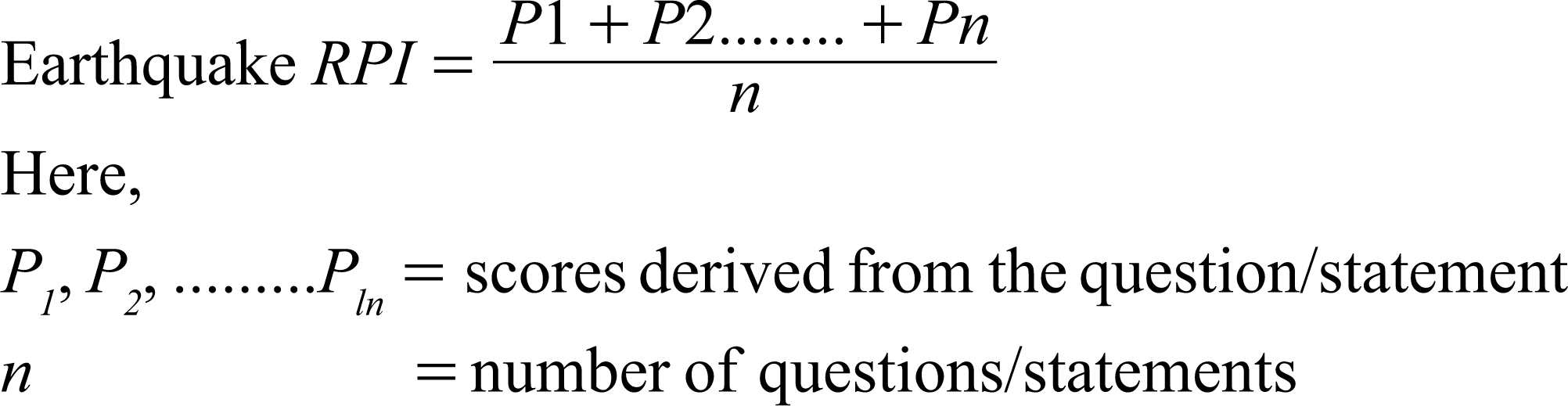
Questions 2–5 were coded on a 5-point Likert scale (from 0 for ‘strongly disagree’ to 1 for ‘strongly agree’), while question number 6 was coded on a 4-point Likert scale (from 0 for ‘not fearful’ to 1 for ‘very fearful’). Questions 1, 7 and 8 were coded on a binary scale, with 1 for ‘high-risk perception’ and 0 for ‘low-risk perception’. A map was generated based on the risk perception score, showing the ERP at the EW level.
Calculating Fire Risk Perception
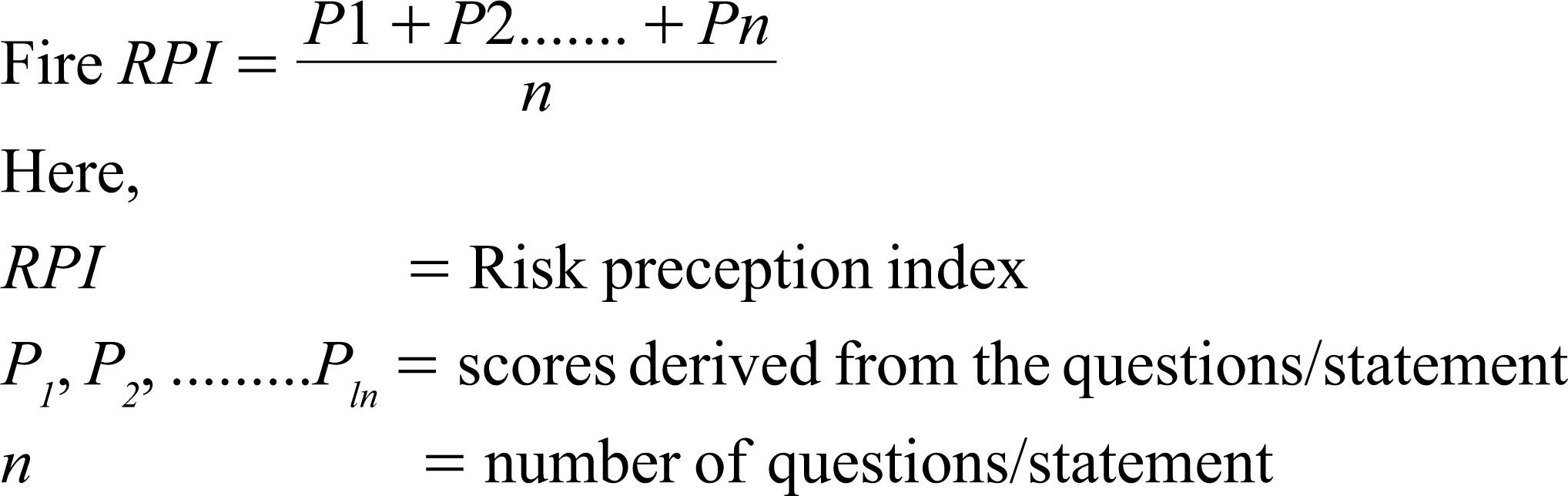
To understand the risk perception of fire hazard at the citizen level, an RPI (Equation 2) was adopted (Chan et al., 2018; Rahman, 2020; Rahman et al., 2021), based on 12 questions (see Appendix A).
Equation 2. Fire Risk Perception Index.
Answers to questions 2, 4, 8 and 9 were coded on a 5-point Likert scale (from 0 for ‘no risk’ to 1 for ‘very high risk’). Questions 3 and 5 were coded on a 3-point multiple-choice scale (1 for ‘yes’, 0.50 for ‘maybe’ and 0 for ‘no’), and questions 1, 6, 7, 10, 11 and 12 were coded on a binary scale (1 for ‘high-risk perception’ and 0 for ‘low-risk perception’).
Indicator Selection and Multiple Deprivation Index Mapping (Theory-driven Index of Multiple Deprivation)
A set of different indicators (Table 3) from various capitals/domains were selected based on the surveyed literature (Baud et al., 2008; DCLG, 2015; Deas et al., 2003; Mishra et al., 2019; Noble et al., 2006; Nthiwa, 2011; Yuan & Wu, 2014; Yuan et al., 2018). To construct an IMD, we adapted the concepts of four capitals (social, human, financial and physical), from Baud et al. (2008), and of natural capital from Mishra et al. (2019). The indicators were normalized following the cost–benefit analysis approach (Baud et al., 2008; Yuan & Wu, 2014): if an indicator increases the IMD score, then it is ‘benefit,’ and if it decreases the score, then it is ‘cost.’
List of Indicators of Multiple Deprivation (theory-driven)
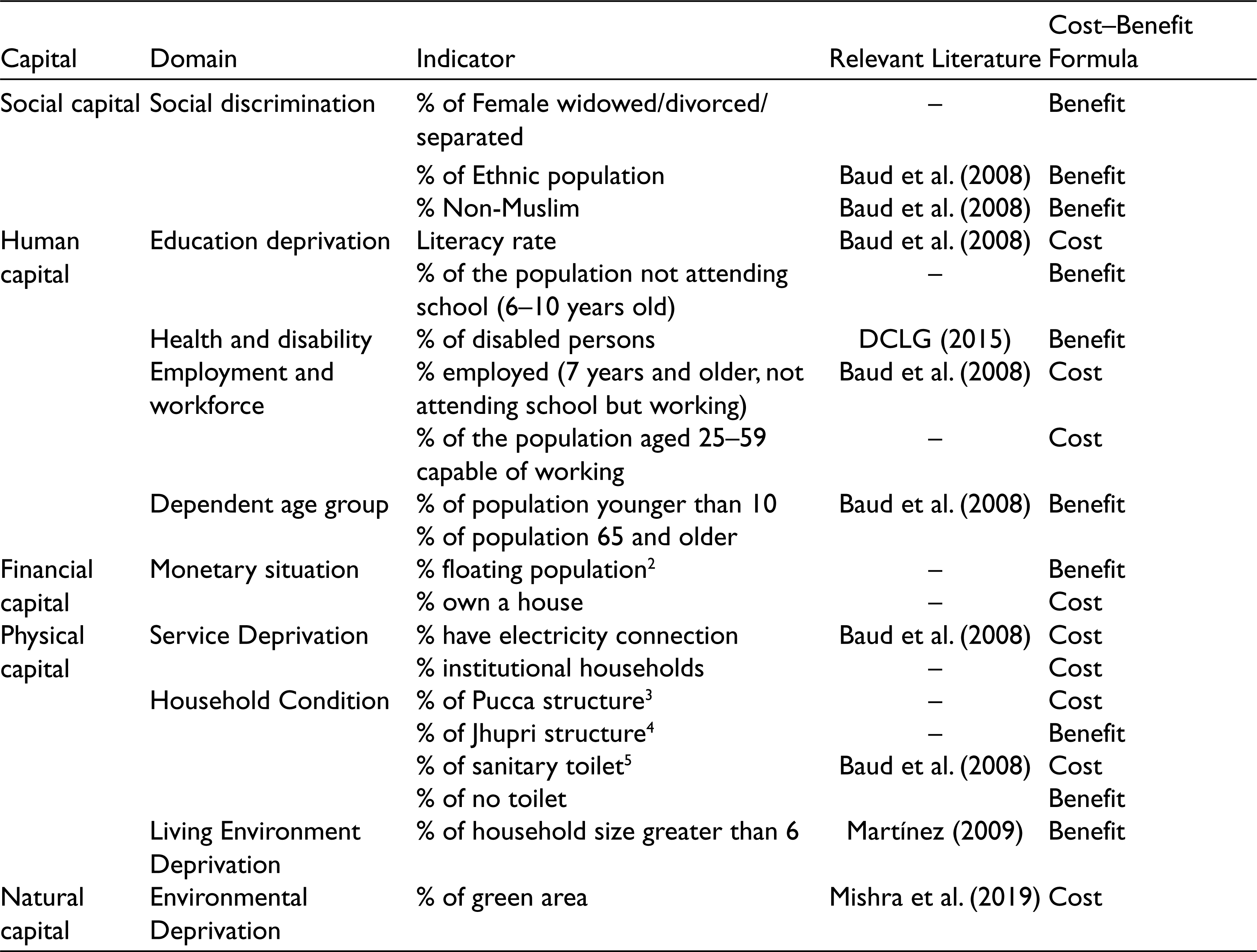
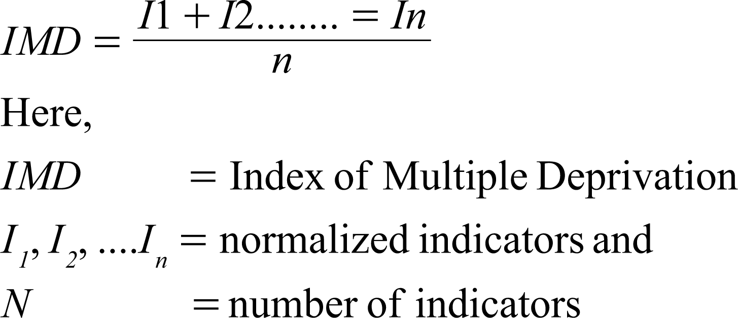
Consequently, the calculation of multiple deprivation was derived from Equation (3). Prior to this step, the value of each indicator was normalized, following the cost–benefit analysis (Equations [4] and [5]). Furthermore, equal weights were assigned to each selected indicator. Weights can be determined by practical and/or research experience (Yuan & Wu, 2014), and for this study, we assigned equal weight to each indicator, following Baud et al. (2008). After combining all attributes, the overall multiple deprivation map was prepared based on the deprivation score of 15 EWs in the study area.
Statistical Analysis
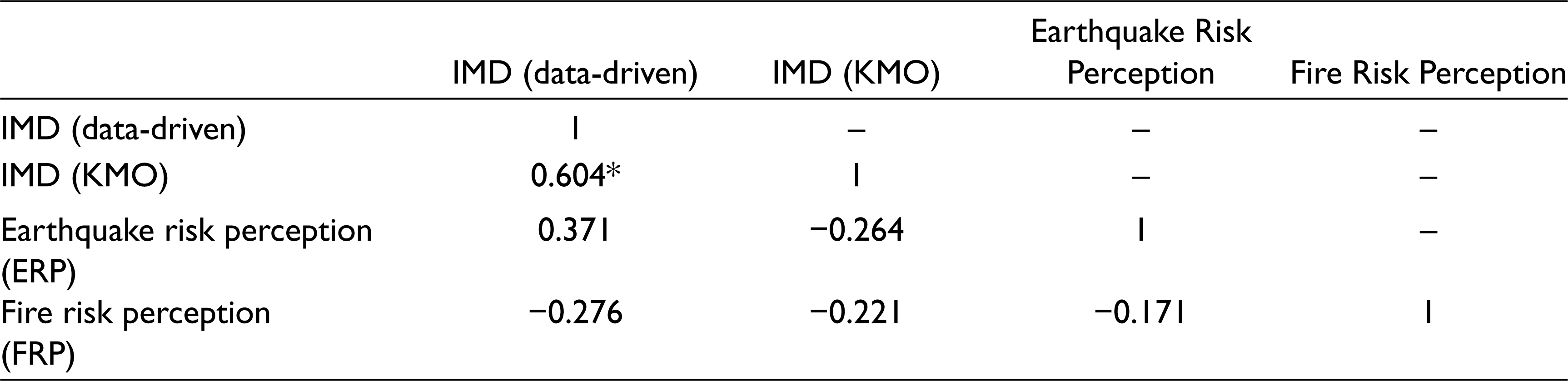
To investigate the relationship between disaster risk perception and multiple deprivation in Rangpur city, we performed Pearson correlation analysis, factor analysis, KMO test and cross-table analysis. At first, Pearson correlation analysis was performed between theory-driven IMD and risk perception (earthquake and fire hazard). Afterwards, we formulated two more indices of multiple deprivation. One is the data-driven IMD (based on field data and the variables are not entirely similar to theory-driven multiple deprivation’s variables), which used a total of nine variables, collected in the surveys: percentage of the population above 59 years old, percentage of households that have more than six inhabitants, percentage of female population, percentage of the highly educated population (bachelor’s degree and higher), percentage of unemployed people, percentage of very low-income group (below BDT 10,000), percentage of pucca structure, percentage of multi-storey buildings and percentage of rented homes. Then, we calculated the data-driven multiple deprivation score for each EW, followed by the normalisation method. The other IMD is based on the KMO test (Mishra, 2018; Yuan & Wu, 2014). To derive this IMD, factor analysis was performed to reduce the indicators of the conceptual model (theory-driven IMD). In this test, we considered eigenvalue more than 1. After several iterations, the KMO value was 0.581, with 10 indicators out of the 20 in Table 3. These 10 indicators showed good communality with a minimum loading value of 0.73, while the highest loading value was 0.948. Then, the KMO-based IMD was calculated, followed by the normalization method.
Results
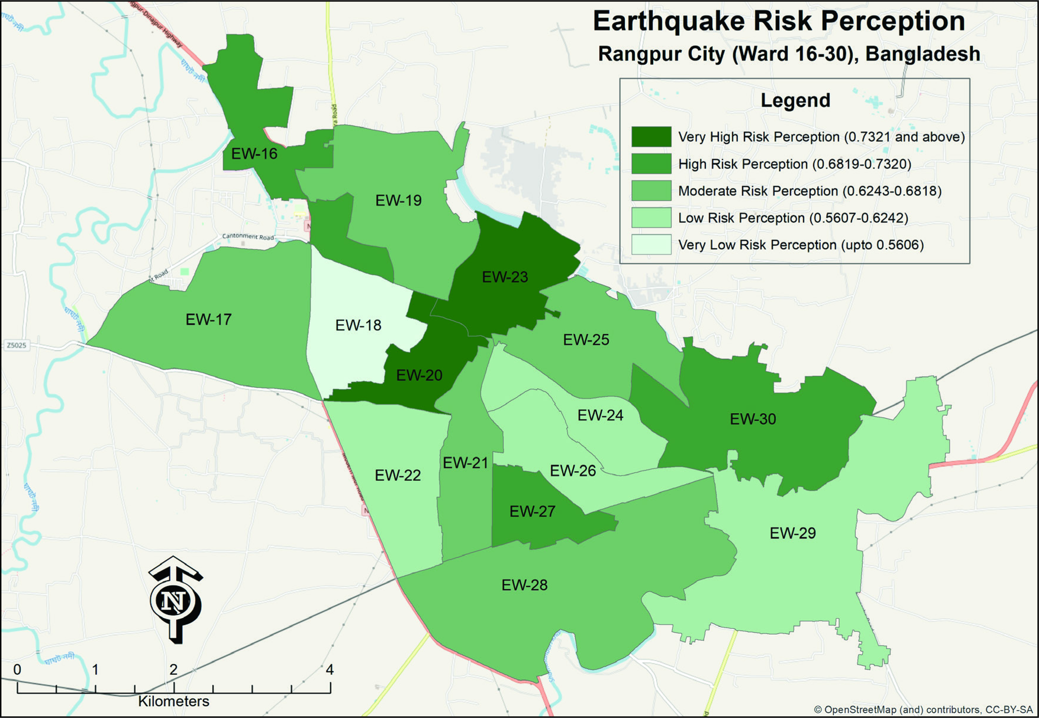
Spatial Distribution of Earthquake Risk Perception
The spatial pattern of ERP is illustrated in Figure 3 (derived via Equation [1]). The ERP classification was done following the natural breaks (Jenks) method and classified into five classes. According to the GIS-based classification scheme, EW20 and EW23 have very high ERP (0.73 and above), and notably, most high-rise buildings are located there. Field observation for this research reveals that residents from high residential levels more likely have high ERP. On the other hand, EW18 has very low ERP (0.56–0.62); which could be explained by the large share of the population living in Jhupri houses in this centrally located EW. Low-risk perception of earthquake hazards was also noted in other EWs that are dominated by single-storey houses (EW22, EW24, EW26 and EW29).
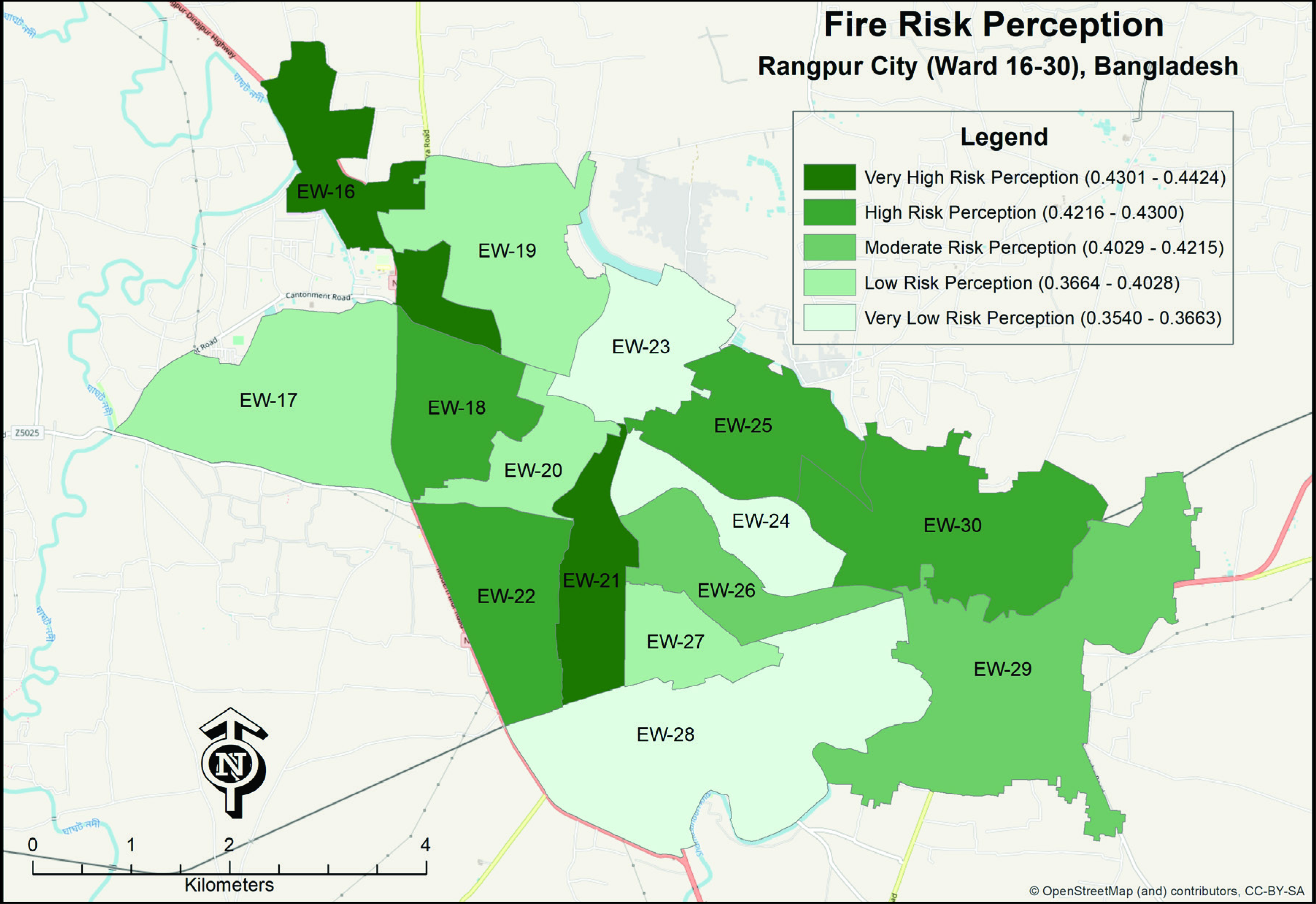
Spatial Pattern of Fire Risk Perception
The spatial pattern of FRP in Rangpur city (using Equation [2]) is illustrated in Figure 4. The FRPs are classified into five groups based on the natural breaks (Jenks) methods as ERP. This figure illustrates that EW23, EW24 and EW28 have very low FRP (0.3540–0.3663). On the other hand, EW16 and EW21 have very high FRP (0.4301–0.4424). EW16 and EW21 have very dense commercial buildings, while EW23, EW24 and EW28 have only a few commercial buildings; this distinction is a major reason behind the pattern. Moreover, people living in the multipurpose buildings (commercial cum residential) tend to be more concerned about fire hazards.
Multiple Deprivation in RpCC
Calculating the IMD (using Equations [1]–[3]) revealed the extent of multiple deprivation in Rangpur city. The multiple deprivation map is also divided into five classes using the natural breaks (Jenks) method. The GIS-based classified map highlights that EW29 and EW30 have the highest level of deprivation (see Figure 5). They are located in the southeastern part of the city, a peri-urban area with few economic activities and services.

On the other hand, EW16 and EW18 have the least deprivation. These two EWs are located in the northwest of the city, where most of the services and jobs are located. This part of the city is well known for hospitals, schools, colleges, shopping malls, administrative units and other urban facilities.
Assessment of the Relationship Between Disaster Risk Perception and Multiple Deprivation
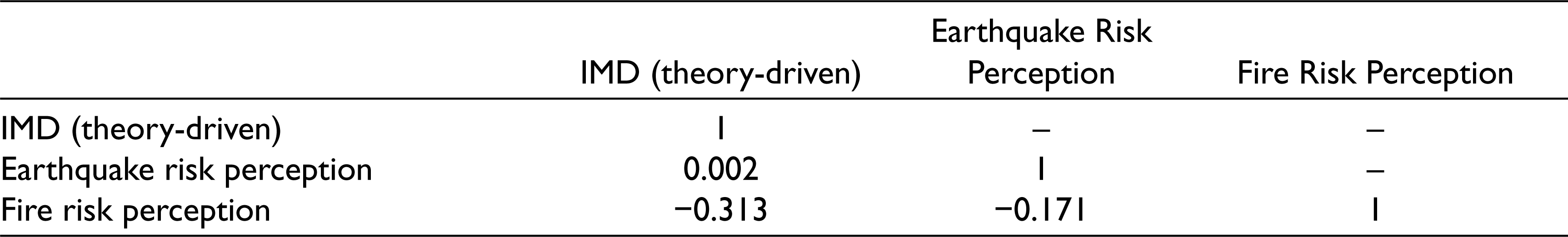
This study’s novel approach was to investigate the relationship between multiple deprivation and disaster risk perception, hypothesizing a strong correlation between multiple deprivation and disaster risk perception. Based on the spatial distribution of IMD (theory-driven), ERP and FRP at the EW level (Table 4), no statistically significant correlation was found between multiple deprivation and disaster risk perception. Similarly, ERP and FRP also do not show any linear correlation.
Correlation (Pearson) Between Multiple Deprivation and Hazards’ Risk Perceptions
We performed another correlation analysis among IMD (data-driven), IMD KMO, ERP and FRP (Table 5). This correlation analysis also showed that ERP and FRP do not have a significant correlation with both types of IMDs.
Correlation (Pearson) Analysis Among IMD (based on field data), IMD (KMO), ERP and FRP
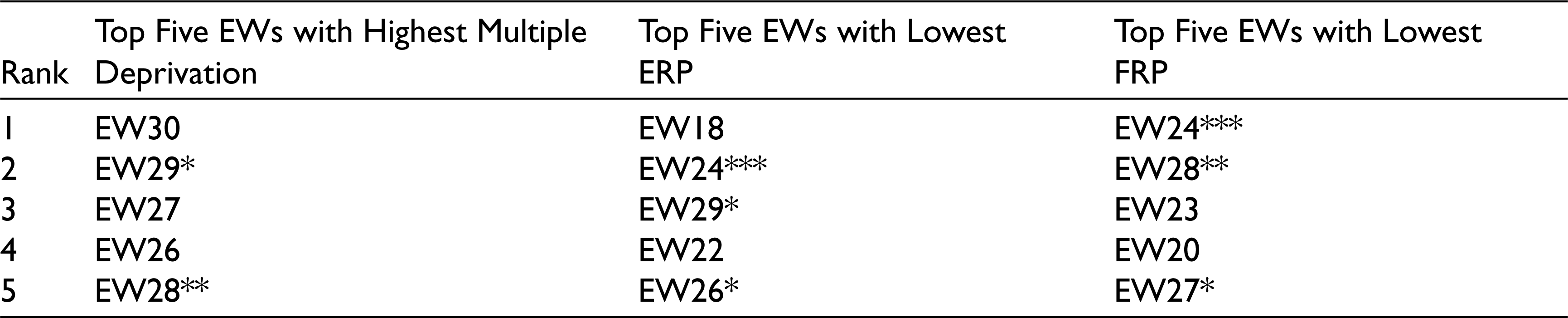
As the Pearson correlation analyses (Tables 4 and 5) do not show any significant relations, two cross-table analyses were conducted to examine the relationship from a different point of view. These efforts revealed valuable insights on this relationship, which could be crucial for planning and policy interventions. The cross-table result shows that EW29 and EW26 ranked 2nd and 4th, respectively, based on multiple deprivation score (Table 6), and these two EWs ranked 3rd and 5th, respectively, for lowest ERP. Similarly, EW28 and EW27 were ranked 2nd and 5th, respectively, based on the lowest FRP. Thus, EW28 and EW29 need much attention because these two EWs have very high or high multiple deprivation and low- or very low-risk perception in at least one hazard category. Moreover, EW24 did not rank in the top five based on multiple deprivation scores, it ranked second for lowest ERP and first for lowest FRP. Apparently, the findings from ‘Table 6’ reveal that EWs with high multiple deprivation likely have low-risk perception.
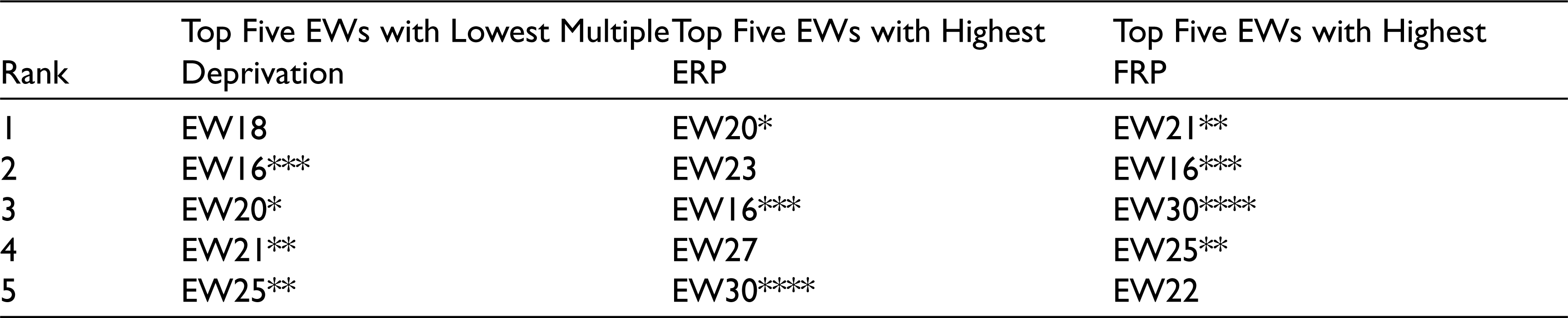
On the other hand, Table 7 shows that EW18, EW16, EW20, EW21 and EW25 are the least deprived EWs of the city, on the theory-driven IMD score. Among these, EW20 and EW16 ranked 1st and 3rd, respectively, based on higher ERP. Similarly, EW21 and EW25 ranked in the top five based on the higher FRP; EW16 remained in the top five in all three categories. EW30 ranked 5th and 3rd, based on higher ERP and higher FRP, respectively. Evidently, the findings from ‘Table 7’ show that EWs with low multiple deprivation likely have high-risk perception.
Cross-table of Top Five EWs with Highest Multiple Deprivation (calculated based on theory-driven IMD), Top Five EWs with Lowest ERP and FRP
Cross-table of Top Five EWs with Lowest Multiple Deprivation (calculated based on theory-driven IMD), Top Five EWs with Highest ERP and FRP
Discussion and Conclusion
The main aim of this study was to investigate the relationship between disaster risk perception and multiple deprivation, using the emerging Rangpur city of Bangladesh as a case study.
The spatial pattern of ERP and FRP hazards in Rangpur city differs from one another, and most people have a higher risk perception of earthquake hazards than a fire hazard. Indeed, distinct hazard characteristics influence risk perception (Sullivan-Wiley & Gianotti, 2017). At the same time, risk perception depends on how people personally perceive the risk (Wachinger et al., 2013). Thus, the spatial pattern of the variation of the risk perception and the risk perception of a particular hazard needed to be considered while designing awareness programmes related to DRR.
In this study, the multiple deprivation map revealed a wide range of deprivation at the EW level in Rangpur city. The core areas of the city have the lowest multiple deprivation, while the peri-urban areas have higher multiple deprivation. Based on the IMD (theory-driven) score, EW29 and EW30 are two times more deprived than EW18, EW16 and EW20. Therefore, these two EWs constitute hot spots of multiple deprivation in Rangpur. Baud et al. (2008) also found a similar type of spatial concentration of multiple deprivation hot spots in the case of Delhi.
Although the correlation results falsified the hypothesis, the cross-table analysis delivered valuable insights that can inform spatial planning and policy interventions. According to the cross-table results, EW28 and EW29 have high multiple deprivation and low disaster risk perception, meaning that they need much attention. On the other hand, EW16 has very low multiple deprivation and very high ERP and FRP. The socio-demographic and risk perception–related characteristics of EW16 could be a model for RpCC to bring out other EWs from deprivation and hazard risks.
In conclusion, the risk perception and multiple deprivation of Rangpur city were analysed using RPI and IMD, respectively. Afterwards, the relationship between disaster risk perception and multiple deprivation was evaluated based on RPI and IMD scores. The maps of the spatial distribution of risk perception could enable planners, policy maker and respective authorities to formulate awareness-raising programmes and to plan guidelines and policy interventions more effectively, in order to reduce hazard risks in Rangpur. Similarly, the multiple deprivation map visualized an overall picture of the city’s deprivation, supporting enhanced communication of the results with local authorities and other stakeholders. Thus, local government and policy makers could use the deprivation analysis to formulate targeted strategies to reduce inequality or deprivation in the city.
While the evaluation of the relationship between disaster risk perception and multiple deprivation did not show any statistically significant relationship based on a few correlation analyses, the cross-table analysis succeeded in showing a relationship between risk perception and multiple deprivation. For example, EWs with higher multiple deprivation score had lower disaster risk perception (EW28 and EW29). Sample size is one of the major limitations of this study. Future research could explore the same issue by gathering additional samples from each EW to put together a more complete picture. Finally, the results from the novel approach of combining multiple deprivation and disaster risk perception could support deprivation and DRR-related planning and policies (e.g., targeting the most vulnerable EWs for DRR-related awareness programmes and training).
Footnotes
Declaration of Conflicting Interests
The authors declared no potential conflicts of interest with respect to the research, authorship and/or publication of this article.
Funding
The authors received no financial support for the research, authorship and/or publication of this article.