
Abstract
Fluctuations in timber/treeline have largely been subjected to past climatic changes; but throughout the Holocene humans became one of the leading drivers of these changes. By understanding the reasons for timber/treeline changes, we retraced past climate variability and/or anthropogenic impact on the alpine environment. This study focussed on the sedimentary sequence of the Lake ‘Jezero v Ledvicah’ (Julian Alps, Slovenia), which is currently located at the treeline and covers the last ca. 6200 years. We used mineralogical and geochemical analyses to understand sedimentary changes in the lake and its catchment area. By combining this dataset with palynological data we tracked the causes of vegetation changes with a focus on human impact. Geological analyses indicate slow continuous and undisturbed sedimentation with a combined biogenic and detrital calcite input throughout the Holocene. High percentage of clay minerals indicate that they were eroded from the catchment bedrock and/or were brought to the catchment indirectly by wind. The palynological results indicate that area around the lake was forested around 6200–4300 cal. BP, with predominant occurrence of coniferous taxa. Infrequent but fairly continuous grazing indicators during this period suggest a human presence in the highlands. By 4300–1100 cal. BP, the human influence in the area increased, resulting in a gradual decrease in tree taxa. Since 1000 cal. BP relatively open landscape developed with increased grazing indicators suggesting a continuous use of highlands.
Introduction
Long–term changes in alpine vegetation composition have been discussed and evaluated for many decades (e.g. Gobet et al., 2003; Pini, 2002; Schwörer et al., 2014; Tinner et al., 1996; Wick and Tinner, 1997). Mainly, to question what were the main drivers that caused those changes (e.g. climate, succession, human impact). The most visible change in the entire alpine vegetation is the shift in timber/treeline (Heiri et al., 2006) with the timberline being the highest elevation where a dense forest ends and the treeline being at the elevation where no individual trees/shrubs exceed 2 m in height (Berthel et al., 2012). Heiri et al. (2006) showed that before 4500 cal. BP climate change (mainly due to temperature changes) was a major cause of shifting treeline. Later, discrepancies between the paleoclimate simulation results and palaeobotanical records indicated stronger human influence. However, disentangling the effects of each driver is often difficult especially with climate change and land use having compounding effects on vegetation in the last couple of millennia (Berthel et al., 2012; Heiri et al., 2006; Wick and Tinner, 1997).
Studies in other parts of the Alps showed that timberline was probably an important habitat for humans throughout the history (Berthel et al., 2012; Schwörer et al., 2014; Walsh et al., 2006, 2014). Yet, no detailed long-term palaeobotanical research has ever been carried out at the treeline/timberline in the Julian Alps and therefore there is no information about long-term vegetation change and possible human impact at that altitude. Only a few studies with limited spacial and temporal comparison on forest cover changes, based on historical cartographic sources (Petek, 2005; Zorn et al., 2015), do exist for Julian Alps. Limited studies showed that modern timberline ranges significantly, mostly between 1600 and 1900 m a.s.l. (Lovrenčak, 1986).
To fill this gap, this study focussed on the lake ‘Jezero v Ledvicah’ (shortly Lake LED), which is located at the current treeline at an altitude of 1830 m a.s.l. First we characterized the processes of lake infill by describing the changes in the lake and catchment in detail using mineralogical and geochemical analyses. We then used stomata and pollen to detect centennial changes in vegetation and whether we can detect and infer the human influence. Finally, we compared these data with those of other Alpine regions with the aim of situating these changes in a more regional context, in particular the common or different trends in the northern/southern and eastern/western parts of the Alps.
Study area
The lake LED is the largest glacial lake in the Triglav Lakes Valley (Dolina Triglavskih jezer), Julian Alps (Slovenia) and is situated at 1830 m a.s.l. (Figure 1a). The lake covers an area of approximately 0.022 km2, and it reaches a depth of up to 14 m. The catchment area of the lake is 1.75 km2 (Dobravec and Šiško, 2002). In the east, a scree descends to the lake and fills the lake basin. In the north and east, the lake is surrounded by rocky cliffs overgrown with grassy vegetation. In the southern part, the lake’s surroundings are flatter and covered with grassland/marsh vegetation and individual larch trees (Dobravec and Šiško, 2002), belonging to the Rhodothamno–Laricetum deciduae tree association (Dakskobler, 2006; Dakskobler et al., 2010), which forms an upper treeline in the Julian Alps (Dakskobler, 2015). Rhodothamno–Pinetum mugo dominates above the treeline, and Adenostylo glabrae–Piceetum and Anemono trifoliae–Fagetum occur below the treeline in the subalpine zone (Figure 1d; Marinček et al., 2002). The climate in the Julian Alps is alpine, with high annual precipitation (2500–3000 mm). The average winter temperature is between 0°C and −3°C, and the summer temperature is between 15°C and 20°C (Ogrin, 1996).
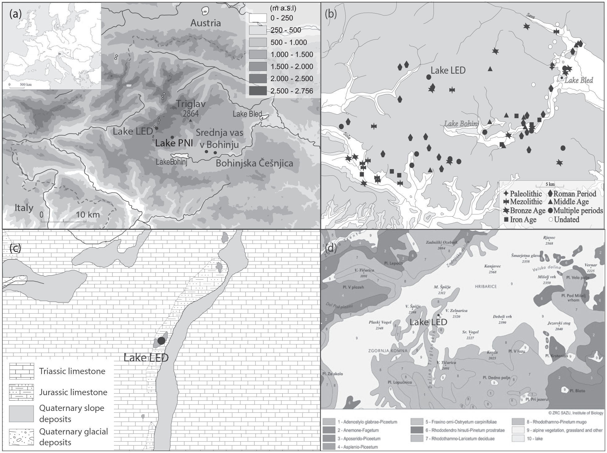
(a) Lake LED study area. (b) Archaeological map (modified after ARKAS, 2004). (c) Geological map (after Buser, 1986, 1987). (d) Vegetation map (Šilc U. and Sajko I., ZRC SAZU, Jovan Hadži Institute of Biology).
Structurally, the Triglav Lakes Valley belongs to the Southern Alps (Placer, 1998). The eastern part of the lake is covered by Quaternary tillite and scree deposits and on the western and southern sides, by karstic marly nodular limestones of the Rosso Ammonitico (Figure 1c, Rožič et al., 2019; Šmuc, 2005; Šmuc and Rožič, 2010). The lake has no permanent surface water inflow (Dobravec and Šiško, 2002), but is probably fed by the small-scale aquifer that is subsided in this part of the valley due to tectonic activity (Rožič et al., 2019).
Brancelj (2002) studied alpine lakes in the Julian Alps with a focus on their flora/fauna and chemical/physical analyses of water (type and amount of organic pollutants, content of heavy metals). Lake LED was found to be one of the least polluted lakes due to its remoteness, while others were more susceptible to human influence. Mainly, the introduction of non-native fish and algal blooms due to continuous human impact resulted in many of them becoming eutrophic.
Archaeological finds in the Triglav Lakes Valley are sparse and poorly dated (Figure 1b). The oldest finds in the wider area of the Julian Alps date to the Palaeolithic period (stone tools; Turk, 2020), but more frequent finds are dated to the Bronze Age (Cevc, 2006) and especially the Roman Period (Ogrin, 2010). To date, there is little evidence of the economic use of highlands, even for specific activities such as pastoralism, ore gathering and logging for metallurgical activities (Cundrič, 2002; Gabrovec, 1966; Ogrin, 2010).
Earlier palynological analyses in the Julian Alps were limited to shorter time periods (Andrič et al., 2010, 2011; Culiberg, 2002), cores were not well dated (Šercelj, 1961, 1963, 1965, 1971) or focussed on lowland sites (Andrič et al., 2009, 2020). However, a study of the Lake PNI core (‘jezero na Planini pri Jezeru’, 1430 m a.sl., Figure 1a) shows human presence in the Julian Alps since the early Neolithic. A more pronounced impact is visible since the Bronze Age and gradually increased until the early Modern Period (ca. 430 cal. BP), when human influence became quite significant, with pastoralism and logging being the main economic activities (Caf et al., 2023).
Methods
Coring
In 2014, two sediment sequences were retrieved from lake LED (13°46.927’E, 46°20.423’N) using an Uwitec gravity corer with hammer (diameter 63 mm): core LED14-01 (213 cm-long, Figure 2) and a short gravity core, LED14-P1 (59 cm-long, see Figure 3). LED14-01 was first cut into two different sections (section A 89 cm and section B 124 cm), then all sections were split into two-halves, photographed at high resolution (20 pixels per mm), described and logged in detail at the EDYTEM laboratory. A precise lithological description was conducted to identify the sedimentary units.
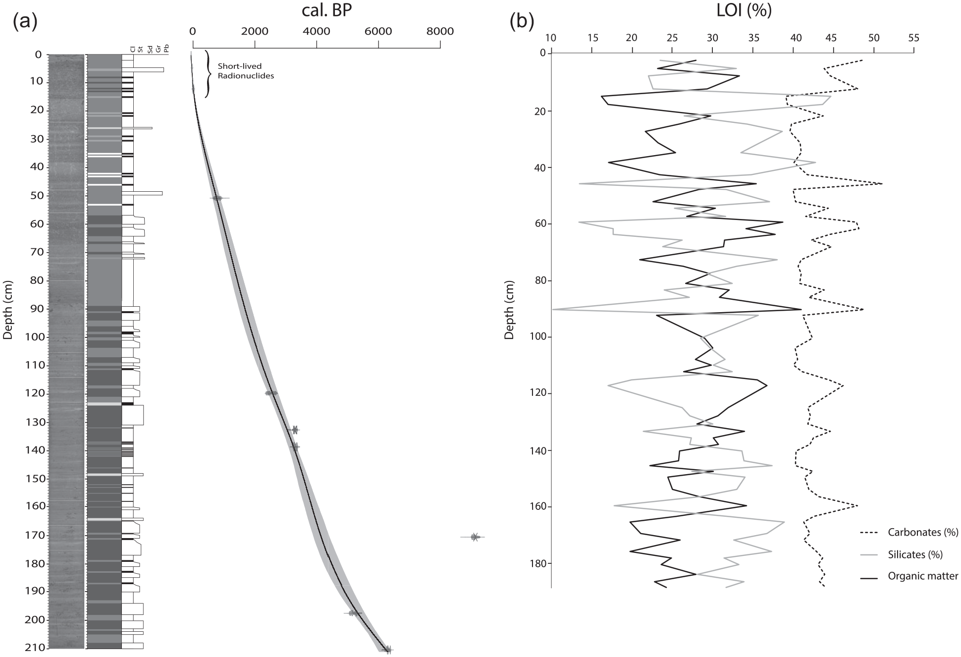
(a) Photography and age-depth model of the LED14-01 sediment core based on seven radiocarbon ages and short-lived radionuclide-derived ages. Two radiocarbon ages were excluded from the age model and are marked in bold in Table 1. (b) LOI data of the LED14-01 sediment core with relative percentages of carbonates, silicates and organic matter.
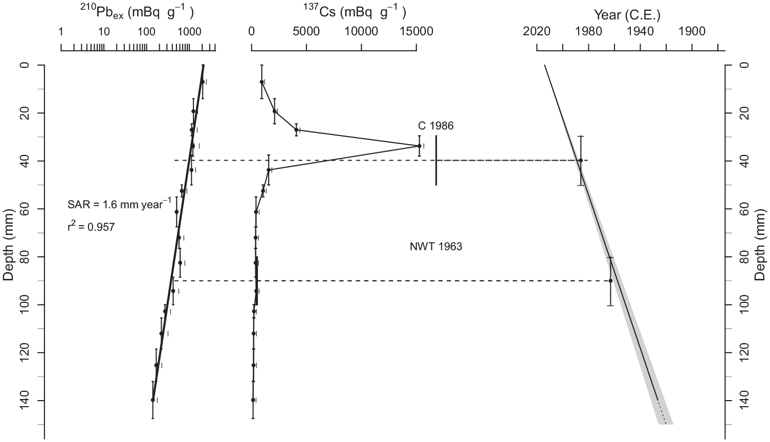
Chronology for the LED14-P1 core with 210Pbex activity, 137Cs activity and CFCS age model with uncertainties (grey area) realized with the serac R package.
Short-lived radionuclides
Sixteen samples were collected on the first 17 cm of the LED14-P1 sequence (upper part of the core, see Figure 3) to measure short-lived radionuclide activities at the Laboratoire Souterrain de Modane using well-type germanium detectors (Reyss et al., 1995). Prior to analyses, samples were dried at 60°C for ∼48 h, and ground to a fine powder in an agate mortar. In general, counting times of 24–48 h were required to achieve a statistical error of less than 10% for excess 210Pb in the deepest samples and for the 137Cs activities. In each sample, the (210Pb unsupported) excess activities were calculated by subtracting the (226Ra-supported) activity from the total (210Pb) activity. The chronology of short–lived radionuclides was performed using the R package ‘serac’ (Bruel and Sabatier, 2020) with the constant flux constant sedimentation (CFCS) model.
Radiocarbon dating
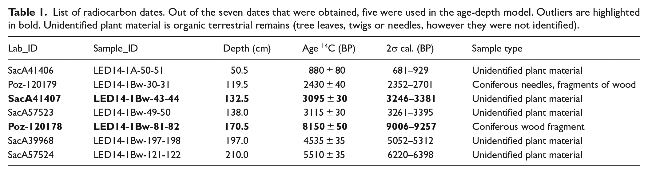
The age–depth model is based on seven 14C dates (Table 1) of plant organic matter measured at the Poznan Radiocarbon Laboratory and the Laboratoire de Mesure 14C (LMC14) ARTEMIS at the CEA (Atomic Energy Commission) Institute in Saclay. The IntCal20 calibration curve (Reimer et al., 2020) was used for radiocarbon age calibration and the ‘clam’ R package (R Development Core Team, 2011) was used to create an age-depth model (Blaauw, 2010).
List of radiocarbon dates. Out of the seven dates that were obtained, five were used in the age-depth model. Outliers are highlighted in bold. Unidentified plant material is organic terrestrial remains (tree leaves, twigs or needles, however they were not identified).
Sedimentology
To complete the visual sediment description, three representative 8-cm-long samples at 21–28, 70–78 and 122–130 cm on core LED14-01 were impregnated with resin to make thin sections of the sediment that were observed with an optical microscope. Loss on ignition (LOI) analysis was performed with a non-continuous sampling step (n = 60) along the sequence following the procedure of Heiri et al. (2001). The sediment was first dried at 60°C during 72 h, then, the samples were crushed before being heated in an oven at 550°C for 4 h and at 950°C for 2 h. The relative weight loss during the first heating phase (hereafter, LOI550°C) corresponds to the fractions of organic matter. The relative weight loss during the second heating phase (hereafter, LOI950°C) is known to be proportional to the carbonate content of the sediment (e.g. Wang et al., 2011).
Mineralogy
The mineral composition of the sediments was determined using X-ray diffraction (XRD) on a Philips X-ray diffractometer (PW 1820) on unoriented powder mounts at the Natural Sciences and Engineering Faculty of the University of Ljubljana. Qualitative and semiquantitative estimations were based on peak intensity measurements of X-ray patterns (Cu Ka/Ni 40 kV, 30 mA) using X’Pert HighScore software.
Geochemistry
X-ray fluorescence (XRF) analysis was performed to characterize the variations of major elements throughout the sediment sequence. This analysis was conducted on the surface of split sedimentary cores, covered with 4 μm thick Ultralene at 2 mm intervals using an Avaatech core scanner (EDYTEM laboratory). Geochemical data were obtained using two tube settings: 10 kV at 1 mA for 10 s for Al, Si, S, K, Ca, Ti and 30 kV at 0.75 mA for 20 s for Cu, Zn, Br, Rb, Sr, Zr, Mn, Fe and Pb (Richter et al., 2006). Three replicates were measured every 10 cm to estimate the standard deviation. Each individual power spectrum was deconvoluted into relative components (intensities), expressed in counts per second. Relative element abundances are expressed as the centred log ratio (CLR) to avoid dilution effects due to water (e.g. Bertrand et al., 2024; Weltje et al., 2015). For the same potential matrix effects, element ratios are expressed as logarithms (ln) of XRF count ratios. The XRF and XRD results were submitted to principal component analysis (PCA) using FactoMineR package in R software to determine correlations between the different measured elements and identify principal sediment end-members (Supplemental S1). To do so, a unique value of XRF was selected for each XRD sample.
Palynological analysis
A total of 66 samples were taken every 1–4 cm from the core (LED 14-01) to obtain a resolution of 50–100 years. A total of 1 cm3 of sediment was collected and prepared following the standard method for palynological samples – Lycopodium spores, HCl, NaOH, HF, acetolysis, safranin dye, and silicone oil (Bennett and Willis, 2002). A minimum of 500 pollen grains were counted in each sample using Nikon Eclipse E400 light microscope. Identification keys, atlases (Beug, 2004; Faegri and Iversen, 1989; Moore et al., 1991; Reille, 1992, 1995) and the reference collection of the Institute of Archaeology, ZRC SAZU were used for the identification of different taxa. Simultaneously, we noted the occurrence of charcoal particles, stomata (Hu et al., 2016) and non-pollen palynomorphs (Sporormiella, Gelorini et al., 2011; Van Geel, 2002 and Pediastrum algae, Van Geel, 2002). To create a pollen diagram, Psimpoll 4.261 programme was used. Samples were divided into zones that were determined with binary splitting by sum-of-square (Bennett, 2005).
Results
Sedimentary units
The sedimentary sequence of LED14-01 consists mainly of olive grey silty clay (Munsel Chart: 5Y/4/2) with a few mm scale black (5Y/2.5/1), olive (5G/3/2) and light grey (N7) laminae (Figure 2). We also found some limestone gravel and organic debris. No event deposits appear to be visible at the centimetre scale, but observation of smear slides allows identification of very fine, ~200 µm thick laminae composed of calcite grains of various sizes (Sabatier et al., 2022). We also observed small calcite crystals (<10 µm), diatoms and small-scale organic matter remains. LOI data show a mean high carbonate content (LOI950 = 43 ± 3%) and high organic matter content (LOI550 = 28 ± 5%) of the core (Figure 2b).
Age-depth model
The 210Pb excess profile (210Pbex) shows a regular decrease (Figure 3) from 2060 mBq.g−1 to low activities (~30 mBq.g−1). We used a logarithmic scale to plot 210Pbex activities and to emphasize a single-point alignment that indicated a well constrained constant sedimentation rate of 1.6 ± 0.1 mm yr−1 (r² = 0.957) for the uppermost 15 cm according to the CFCS model (Bruel and Sabatier, 2020) (Figure 3). The 137Cs profile showed a distinct large peak between 3 and 3.5 cm with a maximum 137Cs activity of >15,000 mBq.g−1. This peak is associated with a peak of 241Am (>10 mBq.g−1) and is widely attributed to nuclear fallout from the 1986 CE Chernobyl accident (e.g. Appleby et al., 1991). The first significant increase in 137Cs activity is seen between 7.6 and 10 cm (217–422 mBq.g−1). This peak probably corresponds to the 1963 CE nuclear weapons testing maximum (Appleby et al., 1991). Both the 1986 and 1963 CE peaks agree well with the sedimentation rate inferred from the 210Pbex profile (Figure 3). Note that the relatively high 137Cs activity dated before the first artificial fallout (1955 CE) is likely related to down core contamination during coring and/or sampling, since the 137Cs activity record during the Chernobyl accident is very high. Chronological markers from these short-lived radionuclides were inserted into the radiocarbon-based age-depth model to constrain it for the upper part of the sediment section. The age-depth model was created using seven 14C dates (Table 1 and Figure 2a). Two radiocarbon dates out of seven were excluded to avoid temporal inversion of the model, probably due to reworked old material in the catchment (see Table 1, in bold, Figure 2a). A smooth spline interpolation was created using the R package ‘clam’ version 2.2 (Blaauw, 2010). The time span of the core is approximately 6200 BP–2014 AD with rather constant sedimentation rate (Figure 2a).
Mineralogy
The sediments of lake LED are composed of different ratios of calcite, dolomite, quartz, illite, kaolinite and chlorite (Figure 4). The majority belongs to clay minerals (approximately 40–70%, upper part 10–40%) and to a lesser extent calcite (10–40%) and dolomite (5–50%), while all other minerals occur in smaller percentages. The exception is the uppermost part of the core, where calcite is the dominant mineral (up to 90%).
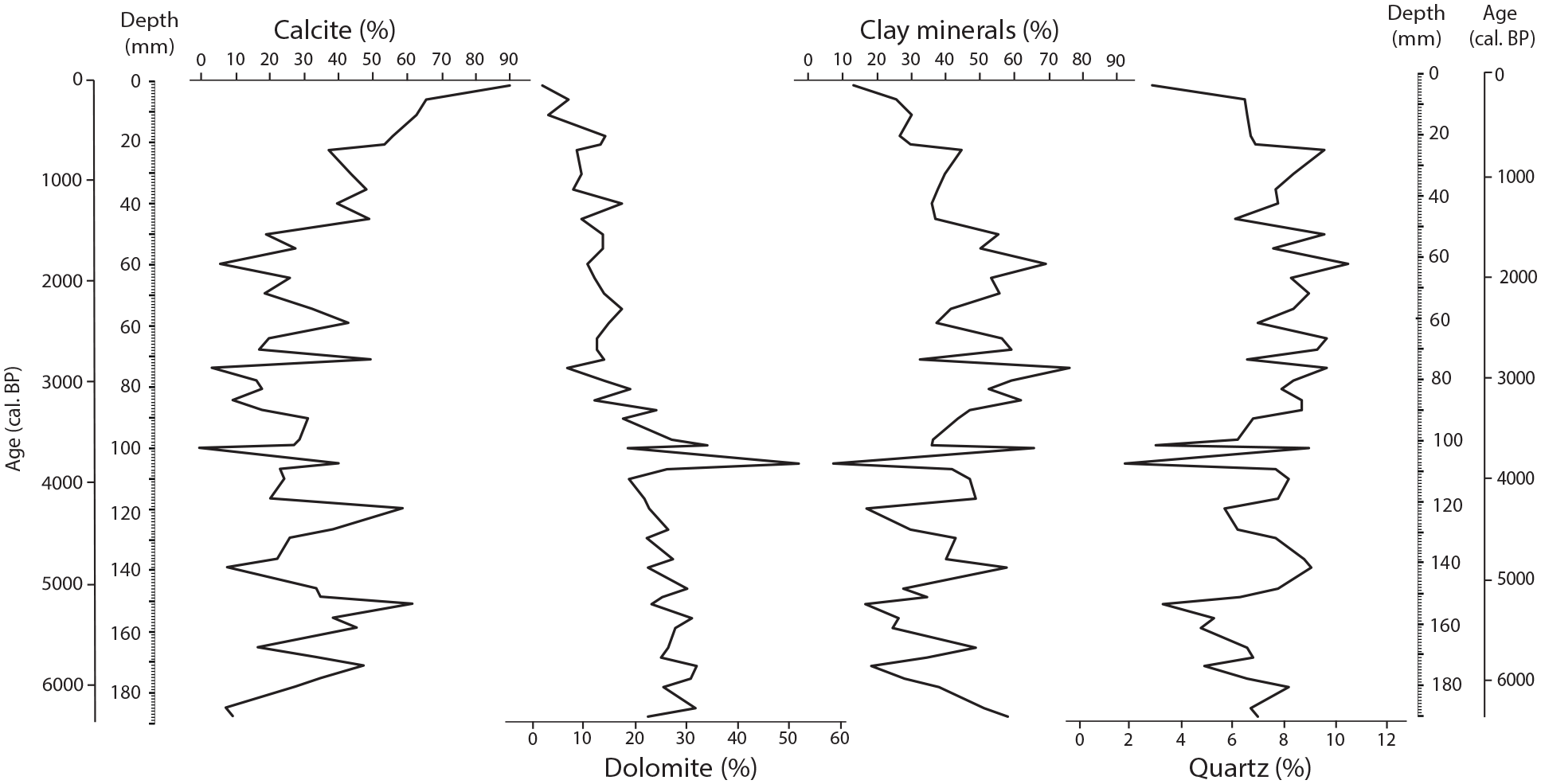
Mineralogical data; each mineral is presented as a relative percentage (%). Within the percentage of clay minerals, illite, chlorite and kaolinite are included.
Geochemistry
Selected geochemical data are presented in this section (Figure 5). The Ti-content shows long-term increase since ~4000 cal. BP and a main short–term increase at ca. 1800 cal. BP. In addition, Sr/Ca, Ca/Ti and Si/Ti ratios are almost constant, with short term variations except ca. 1800 cal. BP, when Sr/Ca increases and Ca/Ti and Si/Ti decrease. In the upper part of the core, a slight increase in Sr/Ti and Si/Ti is observed, related to Ti decreasing. Pb/Rb data show relatively low values until 2400 cal. BP, and three main peaks appeared between 2400 and 1900 cal. BP, 750–480 cal. BP and since 70 cal. BP.
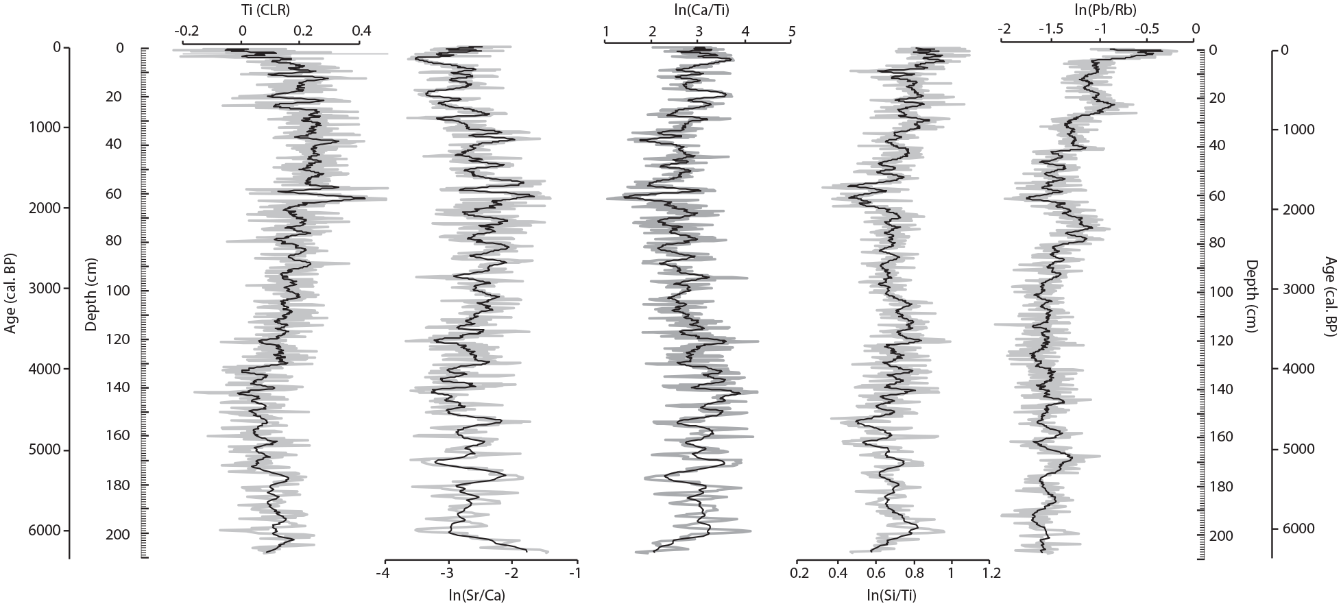
XRF data for LED14-01 with Ti (CLR), ln(Sr/Ca), ln(Ca/Ti), ln(Si/Ti) and ln(Pb/Rb) with an 11-sample moving average in black.
Palynology
The pollen diagram (Figures 6–8) can be divided into 4 zones covering the last ca. 6200 years. Due to low sedimentation rate, centennial resolution of pollen samples could be obtained. In the oldest zone (LED 1) spanning 6200–3400 cal. BP, tree taxa dominate (85–95%). Prevailing taxa are Picea (20–35%), Abies (10–25%), Alnus (10–25%) and to a lesser extent, Fagus (5–20%), Corylus (5–15%) and Pinus (2–10%). Among herb taxa, Poaceae (0.5–10%) have the highest percentage, while other taxa represent a smaller part. However, Plantago lanceolata appears in the samples (approximately 0.5%), with conspicuous absence between 5000 and 4100 cal. BP. Both stomata of various taxa (Picea, Abies, Larix, Pinus, Taxus) and Sporormiella spores sporadically appeared.
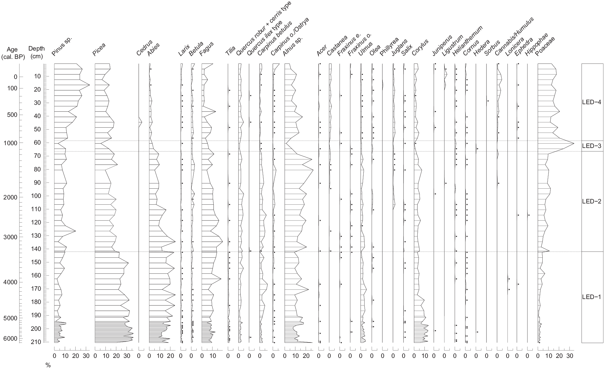
Pollen diagram of selected taxa. Samples marked with a dot are present at <0.5%.
Pollen diagram of selected taxa. Samples marked with a dot are present at <0.5%.
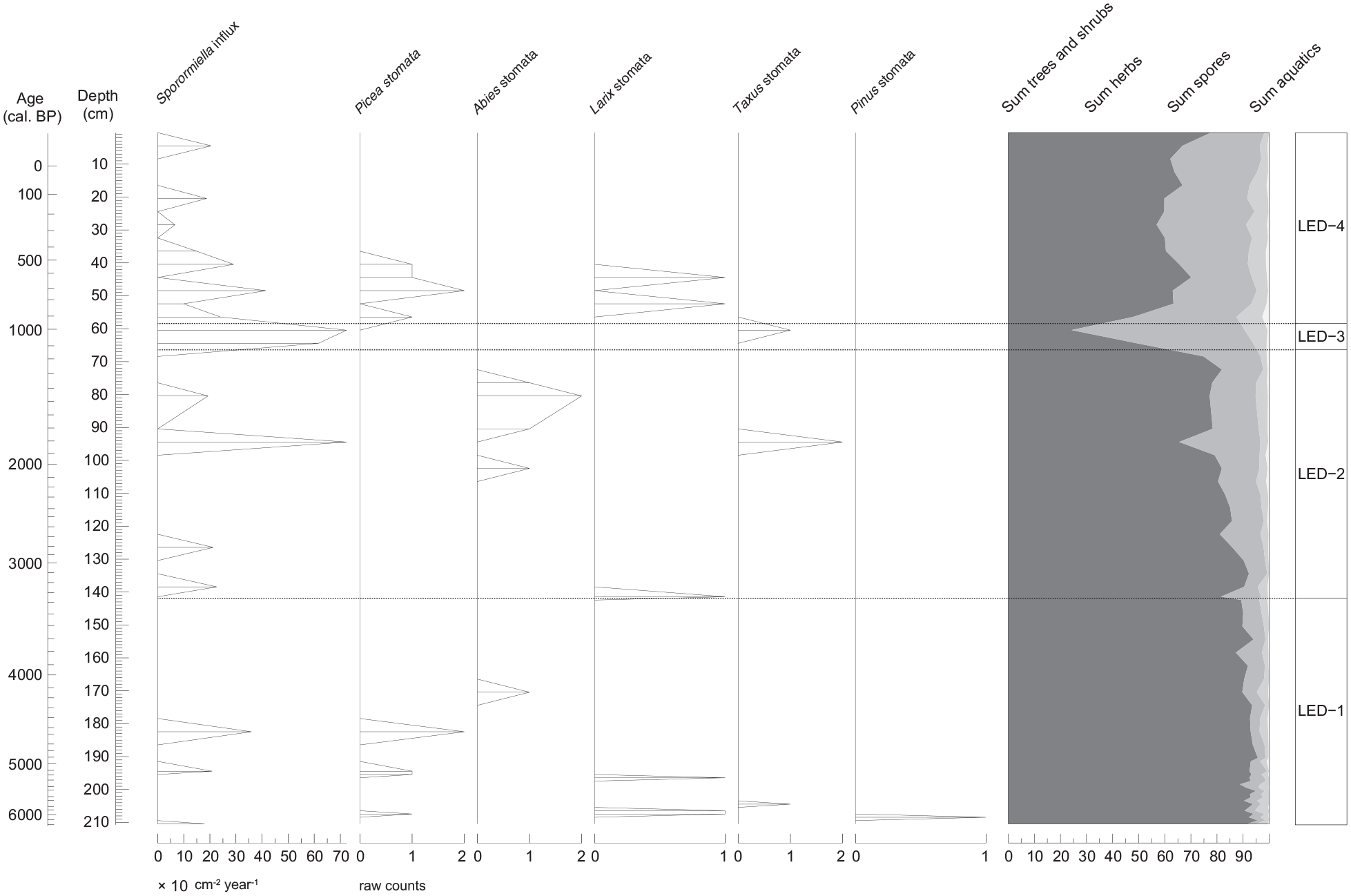
Pollen diagram of selected taxa. Samples marked with a dot are present at <0.5%.
In Zone 2 (LED 2), encompassing 3400–1200 cal. BP, the percentage of tree taxa decreased (65–90%), with Alnus being the most dominant taxon (10–25%), followed by Picea (10–20%), Abies (5–25%), Fagus (5–20%), and Pinus (5–20%). The percentages of Poaceae increased (5–15%); however, other herb taxa also became more common (Plantago lanceolata, Rumex, Asteraceae). Among stomata, fewer taxa were noted (Abies, Taxus, Larix) and Sporormiella spores occurred more frequently.
In Zone 3 (LED 3), which covers 1200–1000 cal. BP, the percentage of tree taxa decreased (25–50%), which is also noted by absence of stomata (with the exception of Taxus). Subsequently, herb taxa increased, especially Poaceae (25–35%). Other herb taxa, such as Leguminosae, Cichoriaceae, Asteraceae, Umbelliferae, Sanguisorba and Caryophyllaceae also increased, overall representing 45–65% of the pollen sum.
Zone 4 (LED 4), which comprises the last 1000 years, shows a relatively open landscape with 50–75% of tree taxa, among which Pinus (10–35%) and, to a lesser extent, Picea (5–15%) and Alnus (5–15%) dominate. The highest values among herb taxa are of Poaceae (10–20%), Plantago lanceolata (1–3%), Rumex (0.5–4%) and Artemisia (0.5–4%). Sporormiella spores frequently appeared in this zone.
Discussion
Sediment source and lake processes
The lake LED is located at relatively high altitude (1830 m a.s.l.) considering the altitude of the Julian Alps (with highest peak being at 2864 m a.s.l.), so limited production of carbonates and silicates was expected (Bajard et al., 2016; Lézine et al., 2010). Yet, the Lake LED sediment section presents rather slow and undisturbed sedimentation with mainly micritic calcareous mud and organic matter (Figure 4). Since the catchment is mostly composed of carbonate bedrock (Šmuc, 2005; Šmuc and Rožič, 2010), rather high values of Si/Ti (Figure 5) indicate mixed input with terrigenous and in-lake production of silica. In-lake production is consistent with the observation of diatoms in thin sections. This coincides with modern samples from the water column, where diatoms have been found (Šiško and Kosi, 2002). In addition, the Ca/Ti (Kylander et al., 2011) and Sr/Ca ratios (Martín-Puertas et al., 2011) suggest two types of carbonate (calcite) input; lacustrine and detrital. Carbonates (calcite, dolomite) are probably associated with a higher Sr content in marine carbonate rocks recorded in the catchment (Rapuc et al., 2022) rather than in the in-lake calcite production (Figure S1). The Sr/Ca and Si/Ti ratios, which show opposite short-term fluctuations, are consistent with the mm-scale calcite layers observed in smear slices probably related to more erosional deposits such as flood deposits. However, no major long-term variations are observed, implying that the calcite sources were mostly constant. No climatic or hydrological changes in the watershed appear to have resulted in drastic changes in the lake or its sedimentation rate (Figure 2a). This may be due to both the small size of the catchment, low rock erodibility and long-lasting ice/snow cover on and around the lake, which limited potential disturbances from the watershed. Muri and Brancelj (2002) showed that the Lake LED is covered by snow between October/November and May/June. This may explain the high values of organic matter in the sediments since oxygen exchange in the water column is limited under snow/ice (Simčič et al., 2002). The mineralogical data show high percentages of clays (up to approximately 75%), which is remarkable in the context of an almost purely carbonated catchment. A potential local source of clay could be Jurassic marly limestone (Rosso Ammonitico Formation) or rare clay interlayers within Lower Jurassic shallow water limestones (Rožič et al., 2019; Šmuc and Rožič, 2010). Moreover, the long-term trend in Ti content since ~4000 cal. BP could also be related to higher aeolian input from African sources after the last African Humid Period as it was already observed in Europe in high elevation lake in Spain (Jiménez - Espejo et al., 2014), Corsica (Sabatier et al., 2020), peat bog in Switzerland (Le Roux et al., 2012) and in Romania (Longman et al., 2017).
Human impact versus climate in the eneolithic
Stomata of Picea, Abies, Pinus, Taxus and Larix appear in the samples between 6200 and 4300 cal. BP, indicating a local presence of these taxa (Figure 8). Together with high percentage of tree taxa (>85%) it could be implied that the timberline was at an elevation of approximately 1800 m a.s.l. or above the lake, with Picea and Abies being the dominant taxa (Figure 6). Studies in the Swiss Alps indicate that between 8700 and 5000 cal. BP (e.g. Wick and Tinner, 1997), the timberline was highest with the treeline at 2400–2500 m a.s.l. (Tinner and Theurillat, 2003). However, in the present-day Julian Alps, in contrast to Swiss Alps, the transition to a steep, rocky ecotone often begins at about 1900–2000 m a.s.l. Above that altitude herbaceous taxa can grow on patchy soils, which are too shallow to allow forest/trees to develop (Leonelli et al., 2016).
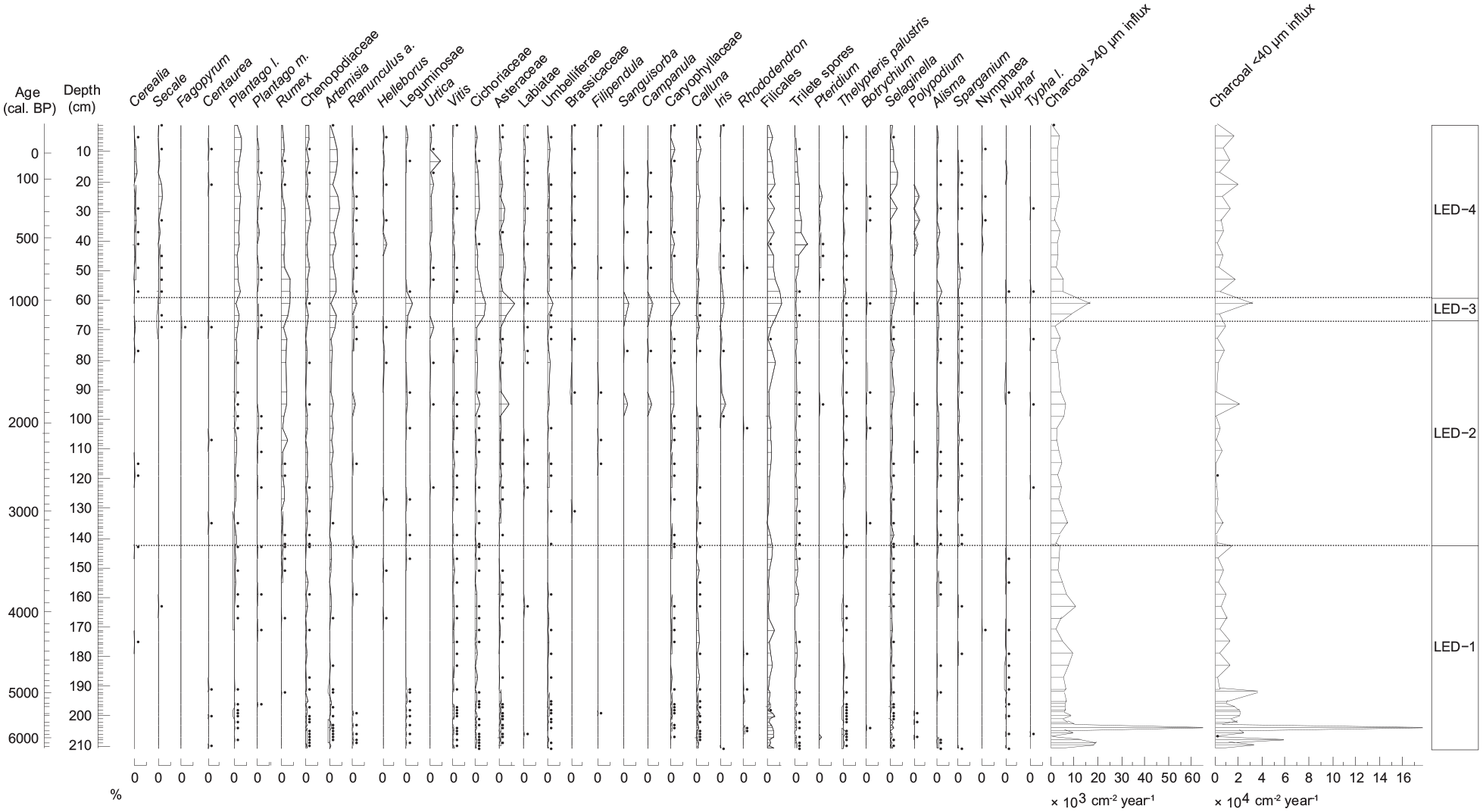
Around 5700 cal. BP there was a slight decrease in the overall percentage of tree taxa, especially Pinus and Picea, followed by an increase in charcoal (ca. 3500 fragments cm−2 yr−1, Figure 7), which may be linked to fires. Fire occurrence at that time could be driven by a short transition to cold/dry climate, as previously observed in the Central Alps (Wick and Tinner, 1997). However, this is unlikely as the percentage of tree taxa remained high (~90%), implying that the long–term forest development was not impacted. Beyond short-term climate fluctuations that unlikely affected these vegetation changes it is human activities that may have been at the origin of the observed decrease in tree taxa. Indeed, Plantago lanceolata and Sporormiella occurred during this period, which could indicate anthropogenic influence (grazing). Similarly, Schwörer et al. (2014) found increased charcoal influx in Switzerland at approximately 5600 cal. BP, which they correlated with Sporormiella spores and the grazing indicator Rumex alpinus, implying a development of anthropogenic activities at that period in the Alps.
Between 5000 and 4100 cal. BP Plantago lanceolata does not appear in the pollen diagram, which is roughly consistent with its absence at the montane Lake PNI site in the Julian Alps (1430 m a.s.l., Figure 1a), where it was absent between 5400 and 4400 cal. BP (Caf et al., 2023). The absence of Plantago lanceolata could be due to abandonment of pastures during this period. Haas et al. (1998) reconstructed a cold phase in the Alps between 5350 and 4900 cal. BP (CE-6). Using Greenland ice cores, O'Brien et al. (1995) recorded a cooling period between 5300 and 4400 cal. BP, indicating a possible regional/global event. In Switzerland, Magny (2004) interpreted two high lake levels during this period, namely, episode 9 (5650–5200 cal. BP) and episode 8 (4850–4800 cal. BP), suggesting wetter periods.
Archaeological findings from this period indicate human presence in the highlands of the Julian Alps, with simple dwellings in Poljanica na Lepi Komni (1630 m a.s.l.) – ca. 4600 cal. BP; Mali Lepoč (1674 m a.s.l.) – ca. 4300 cal. BP and a possible short-term settlement, Kal na Zadnjem Voglu (1495 m a.s.l.) – ca. 5100 cal. BP (Horvat, 2019). However, there is no archaeological evidence of economic activity in this area. In the Western Italian Alps ca. 2300 m a.s.l., the first major anthropogenic impact (increased anthropogenic indicators, dung spores) on the environment was detected between 5600 and 4300 cal. BP (Pini et al., 2017). Furthermore, in the Silvretta Alps (Switzerland/Austria), the first signs of seasonal settlements were dated to the Late Neolithic (4800 cal. BP) and ceramic vessels were found (Kothieringer et al., 2015). Ötzi the Tyrolean Iceman that lived ca. 5200 cal. BP was presumably a shepherd (Müller et al., 2003; Ruff et al., 2006) or alternatively a hunter (Putzer et al., 2016), suggesting that humans did not completely abandon the highlands during the colder phases.
Intensification of human impact from bronze age to modern period
Between 4300 and 1100 cal. BP tree taxa gradually decreased from 90% to 65% (Figure 8). The percentages of Abies and Picea declined the most, suggesting the opening of the landscape. A continuous and steady decline in tree taxa is also observed in the Lake Planina pri Jezeru, Julian Alps (Caf et al., 2023) and Silvretta Alps, Switzerland (Dietre et al., 2020). On the other hand, Pinus and Alnus, light-demanding taxa, increased. This indicates a possible lowering of the timberline and the expansion of the treeline (Tinner and Theurillat, 2003). In addition, no stomata were found between 4300 and 2000 cal. BP (exception being Larix stomata at 3400 cal. BP), suggesting lowering of the timber/treeline. Similarly, in the Central Swiss Alps timberline declined for ca. 300 m and treeline for ca. 100 m indicating expansion of the treeline belt at approximately 4700 cal. BP (Tinner and Theurillat, 2003).
During 4300–2000 cal. BP, small groups of trees comprising Abies, Larix and Alnus were presumably located near the lake LED or possibly even at lower elevations (absence of Pinus and Picea stomata, Figure 8). However, we cannot determine with certainty the timberline/treeline fluctuations because the fossilized stomata are mostly restricted to coniferous taxa (Tinner and Theurillat, 2003). Between approximately 4000 and 3200 cal. BP a colder climate was recorded (Badino et al., 2018; Haas et al., 1998; Leemann and Niessen, 1994), with a temperature decrease of 1.8°C (Badino et al., 2018), which possibly caused the lowering of the timberline. Archaeological sites between ca. 4300 and 3200 cal. BP were relatively scarce (Figure 1b) and were restricted to a range between 1500 and 1800 m a.s.l. By 3200 cal. BP they began to expand to higher elevations (Horvat, 2019). At approximately 4100 cal. BP, Plantago lanceolata started to appear continuously in the diagram, as did occasional Cerealia and Secale pollen grains.
Between 2000 and 500 cal. BP, stomata of Picea, Abies, Larix and Taxus appear in the samples (Figure 8), suggesting coniferous forests near the lake. At 1800 cal. BP, a lower percentage of tree taxa (65%) and a higher percentage of herb taxa (approximately 30%) were observed, with an increase in Ranunculus, Cichoriaceae, Asteraceae, Sanguisorba, Campanula, Iris and a slight increase in Poaceae (Figure 7). At the same time, charcoal (approximately 1000 fragments cm−2 yr−1) and the Sporormiella influx (approximately 25 spores cm−2 yr−1) increased. In addition, the values of terrigenous elements (Ti-CLR, Figure 5) increased approximately at 1800 cal. BP, indicating a possible intensification of erosion processes (Aufgebauer et al., 2012; Bajard et al., 2016). Moreover, lower ln(Ca/Ti) and ln(Si/Ti) values indicate a decrease in primary in-lake production at that time (Figure 5). High values of siliciclastic sediments make up the majority of the sediment (clays 76.5%) as opposed to low carbonate content (dolomite 7%, calcite 5.8%, Figure 4). All of this indicates a sudden opening of the landscape (ca. 150 years), which led to the erosion of allochthonous material as soils were more exposed to rainfall (Bajard et al., 2017).
The use of the highlands during the Roman Times is further evidenced by the discovery of a Roman bell, dated to between the 1st and 3rd centuries AD (Ogrin, 2010), which roughly coincides with our records. The bell was found in Vodene Rupe, east of the Triglav Lakes Valley (ca. 2.5 km from the lake), in a recent treeline/grassy area, therefore indicating the presence of livestock (Ogrin, 2010). Moreover, at Poljanica na Lepi Komni (ca. 6 km southwest of Lake LED), Roman pottery, coins and fibulae were found (Ogrin, 2010).
Juglans appeared at 2200 cal. BP and Castanea started to appear more continuously at approximately 1800 cal. BP (Figure 6), which could be attributed to the anthropogenic spread of those taxa favoured by Romans (Mercuri et al., 2013).
Between 1100 and 1000 cal. BP, the percentage of tree taxa decreased significantly (to 25%), especially Pinus, Picea, Abies and Alnus, and the percentage of herb taxa increased to 65%. Poacease increased the most (approximately 30%), but Leguminosae, Cichoriaceae, Asteraceae, Umbelliferae, Sanguisorba, Campanula and Caryophyllaceae also increased (Figure 7). In addition, charcoal (approximately 2200 fragments cm−2 yr−1) and the Sporormiella influx (32 spores cm−2 yr−1, Figures 7 and 8) also increased. It is possible that another slash-and-burn event occurred that caused the spread of herbaceous taxa, which was also identified with a short erosion increase (Ti, Figure 5) most likely to open up the landscape for grazing (Dietre et al., 2014; Gilck and Poschlod, 2019). Although there are no archaeological finds from the Early/High Middle Ages in the area around Lake LED, at Krstenica (6 km southeast of Lake LED) a simple dwelling was found (Horvat, 2020). Two remains of buildings that indicate mediaeval settlements were found in the Konjščica summer pasture complex (1440 m a.s.l.), located approximately 9 km east of our site (Horvat, 2018).
Taxus stomata were found during the increased charcoal input at 5700, 1800 and 1000 cal. BP (Figure 8), suggesting the local occurrence of Taxus. The use of Taxus has often been associated with grazing activities, particularly the use of yew branches for fodder (Delhon et al., 2008; Thomas and Polwart, 2003) or burning dung using yew wood (Uzquiano et al., 2015). In addition, branches of Taxus have low flammability compared to most coniferous taxa, suggesting that Taxus was able to survive when other conifers were damaged by fire (Thomas and Polwart, 2003).
From 1000 cal. BP the area around the lake was rather open with the percentage of tree taxa between 60 and 65%. In the last century, however, reforestation started with tree taxa reaching up to approximately 75% of the total pollen sum (Figure 8). The percentage of Abies, which is sensitive to grazing (Tinner et al., 1999), decreased to less than 5%, probably due to continuous grazing in the area. A higher Sporormiella spore content is also observed, within flux values reaching up to 40 spores cm−2 yr−1 (Figure 8).
Historical mediaeval archives noted two pastures near the lake LED (Melik, 1950). These are Planina Ute (also ‘pri Utah’, 1 km away from Lake LED at 1750 m a.s.l) and Planina Pri jezerih (ca. 3 km from Lake LED at 1680 m a.s.l.). Archaeological excavations at Planina Ute yielded iron axe that could be dated to Early Middle Ages, and charcoal that was dated to High Middle Age (903–695 cal. BP; Horvat, personal communication). Kos (1960) postulated that those pastures belonged to the oldest villages in the area of Lake Bohinj, Srednja vas v Bohinju and Bohinjska Češnjica (Figure 1a). Today, the name Bohinj is not directly used for any village, but Srednja vas v Bohinju was sometimes called ‘Bohinj’ (in loco Bochingun, villa Bochingin) and is mentioned under these names as early as the second half of the 11th century (ca. 900 cal. BP; Kos, 1960). Melik (1950) also argued that in the Middle Ages there were many disputes between herders. However, in the Modern Times wood was needed for metallurgy in the lowlands, which led to additional disputes between herders and foresters/miners (Melik, 1950). Many pastures were abandoned (such as Pri jezerih), partially to preserve forests, but mostly due to the Julian Alps being protected as a national park since the second half of the 20th century (Bajuk Senčar, 2014; Kos, 1960; Melik, 1950).
Importance of pastures near timber/treeline
Numerous archaeological sites in the Julian Alps indicate early use of the highlands, with first finds dated to ca. 5100 cal. BP (Kal na Zadnjem Voglu, Horvat, 2020). This is in agreement with other alpine regions, such as the Bernese Alps, where a wooden bowl was dated to 6500–6300 cal. BP (Hafner and Schwörer, 2018), leather legging and bow case to 4900–4700 cal. BP (Hafner, 2012).
Horvat (2019) noted that archaeological finds in the Julian Alps are quite rare and normally not visible on the surface. However, the continuity of human presence can be inferred, mainly with natural grazing areas near the timberline being the most important sites. Figure 9 shows that some of archaeological sites always moved to higher elevations when the presumed timber/treeline shifted to higher altitudes. This indicates that humans depended on the proximity of pastures and forests (trees). This is essential, because the alpine zone in the Julian Alps is relatively narrow and steep, which limits the extent of large-scale pastures. Melik (1950) argued that natural or anthropogenic pastures near the timber/treeline provided sufficient grass for livestock, as opposed to lower (especially montane) sites, where forests were the dominant vegetation. Furthermore, herders needed wood for building settlements and firewood, which were available nearby. This is in agreement with sites in the southern French Alps (ca. 2000 m a.s.l.) where Leveau and Walsh (2005) noted that open grasslands that were used for many economic activities (grazing, hunting, collecting ore) were next to the treeline.
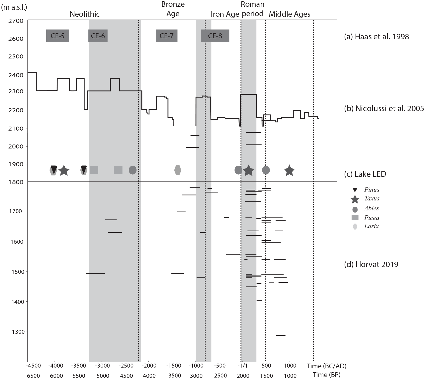
Combined data of (a) reconstructed cold phases on the Swiss Plateau (Haas et al., 1998). (b) Timberline fluctuations in the Austrian Alps (Kothieringer et al., 2015; Nicolussi et al., 2005). (c) Stomata found at the lake LED at an altitude of 1830 m a.s.l. (d) Archaeological sites in the Julian Alps (Horvat, 2019). All sites listed were radiocarbon dated, with horizontal lines presenting 2 sigma (δ) range of each 14C date. Grey colour represents phases of higher timberline, to clearly see the extent of archaeological sites in periods of timberline being at different altitudes. Since no known timberline fluctuations have been postulated for the Julian Alps, it could be indicative that people used higher elevation sites when the timberline in the Alps was higher.
For the Middle Ages and Modern Period, Carrer (2012) assumed that when the population increased in Italian Alps (Trentino-Alto Adige region), pastures were established in the lowlands and in the montane zone. Walsh et al. (2014) argued that during the Mediaeval Period, expansion of pastoral activity caused lowering of the treeline, which in turn caused the usage of the montane belt that was previously less exploited. Since winters were relatively long, enough hay had to be stored to feed the animals. Meadows in the lowlands were used for this purpose, mainly because the grass there grew much faster and was easier to transport than in the highlands. In addition, keeping cattle in the highlands during the summer allowed lowland meadows to produce enough grass for the entire winter, whereas keeping cattle in the lowlands would limit the available grasslands (Carrer, 2012; Melik, 1950; Oitzl, 2018; Zwitter, 2015).
In addition, a deterioration of the climate during certain archaeological/historical periods has been suggested as the main reason for the absence of human activity in the highlands. However, this assumption is probably too simplistic (Walsh et al., 2006). Leveau and Walsh (2005) argued that during periods of climate deterioration, no clear relationship can be assumed between the presence or absence of human activity in high alpine zones. They suggested that cultural processes were the main cause of human relocation to higher altitudes. Tinner et al. (2003) argued that although colder periods caused lower crop production, the humid conditions were more problematic, causing parasite attacks and crop loss. However, they concluded that the combination of social and climatic conditions favoured the presence of humans in the highlands. This can also be confirmed by palaeoecological and archaeological research in the Julian Alps (Andrič et al., 2011; Caf et al., 2023; Horvat, 2019), where increased activity was found during warmer periods (e.g. Bronze Age, Roman Period), but no complete abandonment occurred during colder periods (Figure 9a and d, Horvat, 2013, 2019; Ogrin, 2010, 2020).
Conclusions
Long-term environmental changes in alpine regions can be often challenging to reconstruct. Therefore, to understand those changes, we used a multi–proxy approach based on the study of a sediment sequence from an high-altitude alpine lake (Lake LED). By combining mineralogical and geochemical data, we found that prolonged snow cover on the lake with restricted catchment, limited disturbance from the watershed composed of rocks with low physical erosion, resulting in higher accumulation of organic matter. Larger amounts of clay in lake sediments are most likely due to a combination of transport from bedrock (clay interlayers within Lower Jurassic shallow water limestones and Rosso Ammonitico Formation) and aeolian transport, with clay minerals being resedimented from the catchment.
By combining pollen and charcoal data with geochemical analysis, we found that at ca. 6200–4300 cal. BP coniferous forests thrived around the lake LED, as evidenced by the stomata of coniferous taxa. However, occasional anthropogenic indicators occurred as soon as ca. 6000 cal. BP (Plantago lanceolata, Sporormiella), with a fire event at 5700 cal. BP, indicating a low anthropogenic impact on the environment around the lake.
Between 4300 and 1100 cal. BP, combined decrease of tree taxa and absence of stomata indicate lowering of the timberline. However, percentages of Alnus and Pinus pollen increased, possibly implying an expansion of the treeline. This could be due to both colder period (ca. 4000–3200 cal. BP) or human activity (appearance of anthropogenic indicators/archaeological sites). At 1800–1100 cal. BP, increased charcoal and Sporormiella influx, combined with the increased herbaceous taxa, indicate that the area may have been cleared for pasture development, which caused physical erosion and released siliciclastic sediments stored in the soils in the watershed. From ca. 1000 cal. BP, the area around the lake was open, with possible pastures located in the treeline ecotone.
People depended on the proximity of pastures and forests and therefore adjusted their highland settlements near or next to timber/treeline. In view of climate change and consequent worsening conditions for the economic use of the highlands in colder periods, it is striking that humans never completely abandoned the highlands of the Julian Alps. Instead, we show here that they just used them to a lesser extent than in the warmer periods, when the palaeoecological and archaeological evidence is more evident.
This work is the first in the Julian Alps that focussed on long-term reconstruction of vegetation change at the timber/treeline and what were the main drivers of its change. This is particularly important for future understanding high altitude vegetation changes, especially with upslope migration of forests due to predicted global warming and abandonment of economic activities in the highlands.
Supplemental Material
sj-pdf-1-hol-10.1177_09596836241307300 – Supplemental material for Human influence at the Holocene treeline in the Julian Alps, Slovenia
Supplemental material, sj-pdf-1-hol-10.1177_09596836241307300 for Human influence at the Holocene treeline in the Julian Alps, Slovenia by Nina Caf, Pierre Sabatier, Julia Cucinotta, William Rapuc, Matej Dolenec and Andrej Šmuc in The Holocene
Footnotes
Acknowledgements
We would like to thank U. Šilc and I. Sajko for providing vegetation map (Figure 1d) of the studied area, D. Valoh, J. Rihter and M. Belak for their help with providing and preparing the maps, F. Söderblom for his significant help with R and special thanks to M. Andrič for critically evaluating the manuscript. 14C analyses were acquired thanks to the CNRS-INSU ARTEMIS national radiocarbon AMS measurement programme at the Laboratoire de Mesure 14C (LMC14) of the CEA (French Atomic Energy Commission) Institute at Saclay. The authors thank the Environnement, Dynamique et Territories de Montagne for the X-ray fluorescence analyses. We thank the Laboratoire Souterrain de Modane facilities for the gamma spectrometry measurements.
Author contribution(s)
Funding
The author(s) disclosed receipt of the following financial support for the research, authorship, and/or publication of this article: This research was funded by the Slovenian Research and Innovation Agency, programmes P6-0064 (Archaeological research) P1-0195 (Geoenvironment and geomaterials) project J7-1817 (5000 years of grazing and mining activities in the Julian Alps (Slovenia): climate–human interactions as reflected in lake sediments, man-modified landscape and archaeological findings) and funding a PhD project to N. Caf.
Supplemental material
Supplemental material for this article is available online.
References
Supplementary Material
Please find the following supplemental material available below.
For Open Access articles published under a Creative Commons License, all supplemental material carries the same license as the article it is associated with.
For non-Open Access articles published, all supplemental material carries a non-exclusive license, and permission requests for re-use of supplemental material or any part of supplemental material shall be sent directly to the copyright owner as specified in the copyright notice associated with the article.