
Abstract
In the highlands of Papua New Guinea (PNG), tephras are key chronostratigraphic markers for archaeological and palaeoenvironmental studies. Here, mid-Late-Holocene tephras are geochemically fingerprinted and correlated across seventeen sites in PNG. This enables the first regional scale assessment of the distribution of these tephras, with implications for both assessing eruption magnitude and interpreting site stratigraphy. In the past, stratigraphic relationships have been key to much of the tephra identification done in PNG. Fingerprinting presented here shows that tephras may be either locally or regionally absent, as a result of poor preservation or regional distribution patterns, reinforcing the need for geochemical identification. Fingerprinting has also allowed tephras to be correlated with their source volcano. In a number of cases (e.g. Kuning and Mun tephras), this has enabled significant refinement of tephra ages, as source eruptions have been accurately dated using charcoal in proximal pyroclastic sequences. This has significant implications for regional archaeological and palaeoenvironmental studies. Of the six regionally widespread tephras emplaced over the last 4–5 ka in PNG, four are sourced from either Long Island or Karkar volcanoes in the western Bismarck Arc, while two are the result of eruptions from Dakataua and Witori volcanoes in New Britain. Discovery on the PNG mainland of tephras sourced from New Britain significantly increases the known distribution of products from these eruptions, suggesting current evaluations of eruption magnitude may be underestimates.
Introduction
Tephras are valuable chronostratigraphic marker horizons, allowing environmental or geological sequences to be accurately correlated and dated (e.g. Lowe, 2011). In the highlands of Papua New Guinea (PNG), tephras provide a stratigraphic framework for archaeological and environmental investigations of late Pleistocene to Holocene sequences, contributing to debates about the emergence of agriculture and consequent environmental and ecological changes (e.g. Denham et al., 2003; Golson, 1977; Haberle, 1998; Sniderman et al., 2009). The highlands tephra sequence has been most thoroughly documented at the Kuk archaeological site, where at least eight 10–60 mm thick Holocene tephras have been identified (Blong et al., 2017b). These tephras are believed to be sourced from volcanoes along the Bismarck Arc (Blong et al., 2017b), an active subduction zone along the northern margin of New Guinea (Figure 1). Prevailing winds at altitude blow from the east, dispersing tephra from these volcanoes across the PNG highlands (Blong, 1981). The Bismarck Arc is recognised for its abundance of young caldera volcanoes (e.g. McKee et al., 2011) which have produced at least 14 Plinian eruptions of VEI 6+ (i.e. large enough to loft volcanic ash > 225 km from the arc to the highlands) during the Holocene (e.g. Heming, 1974; Machida et al., 1996; McKee et al., 2011; Pain et al., 1981). Two of these have been linked with tephras from the highlands sequence: The Tibito tephra is related to the 1665–1668 CE eruption of Long Island (Blong, 1982; Blong and Kurbatov, 2020), while the Olgaboli tephra has tentatively been linked with an eruption at Karkar volcano (Schneider et al., 2017). The source of the remaining tephras remains a point of speculation (e.g. Blong et al., 2017b).
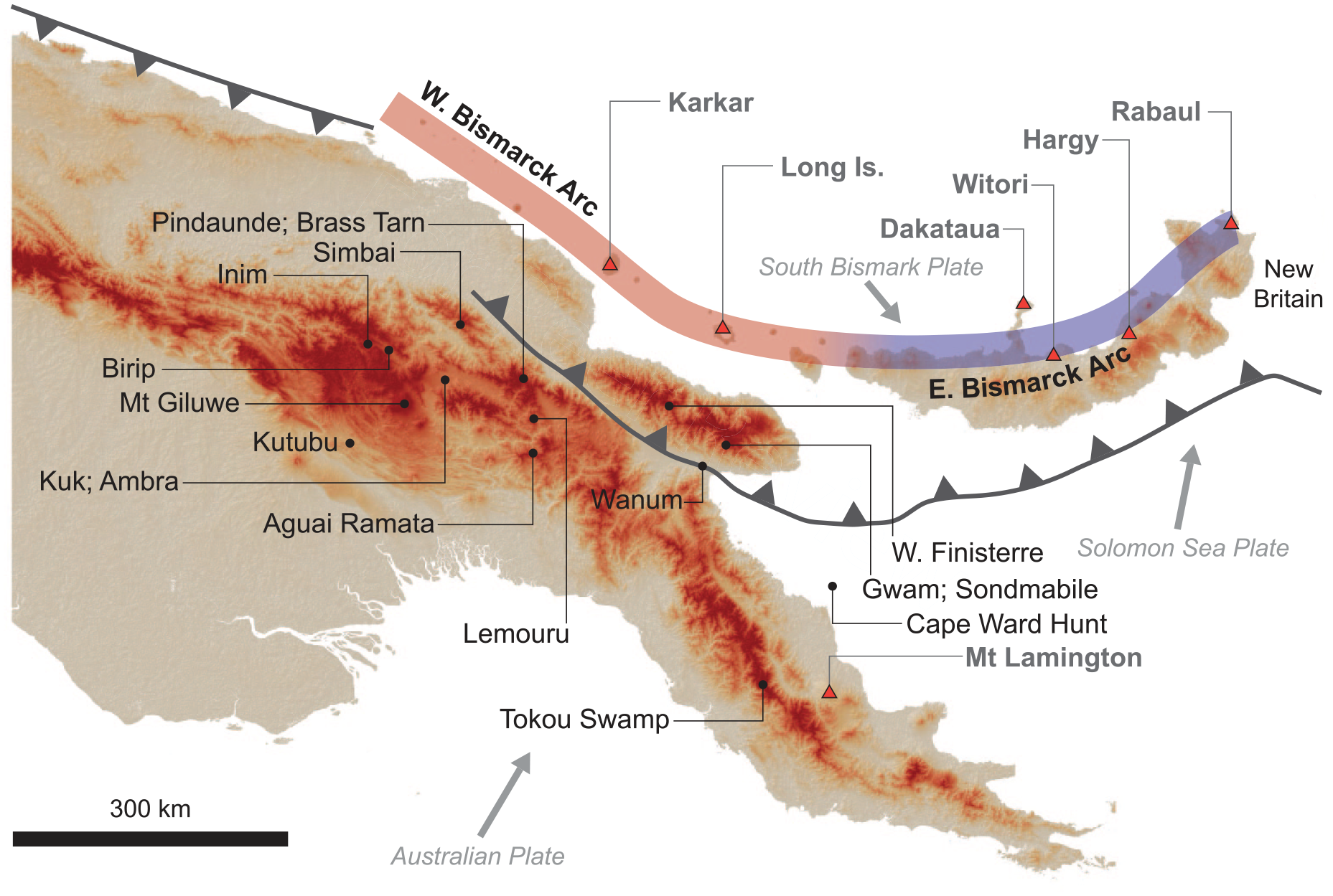
Map of Papua New Guinea showing the location of tephra sequences examined (black circles) and potential source volcanoes (red triangles). The coloured line shows the location of the Bismarck Arc, with the western Bismarck segment (red – for colours see online version) distinguished from the eastern Bismarck segment (blue). DEM base map from ALOS AW3D30 Global digital surface model.
Geochemical characterisation of tephras allows improved fingerprinting as tephras that may appear indistinguishable in the field commonly display geochemical differences (Alloway et al., 2024 and references therein). Tephra geochemistry can also allow distal tephras to be tied back to their source volcano (e.g. Bouvet de Maisonneuve and Bergal-Kuvikas, 2020; Shane, 2000; Tomlinson et al., 2015). This can significantly improve age estimates for the tephra itself. Ages for many of the tephra beds in the PNG highlands are based on dated organic materials from soil horizons above or below the tephra (e.g. Blong, 2024), however proximal pyroclastic deposits commonly contain widespread charcoal, enabling more precise radiocarbon dating of the tephra itself (e.g. Petrie and Torrence, 2008). Age constraints on many of the tephras present in the PNG highlands are poor, with envelopes of hundreds of years in which a tephra may have been deposited. Refinement of tephra ages in PNG is thus necessary (Haberle, 1998). This is particularly important for a number of key sites in the PNG highlands (e.g. Lake Kutubu) where underlying carbonate geology causes reservoir effects, producing erroneous radiocarbon ages (Schneider et al., 2019). Tying tephras to source volcanoes also contributes valuable volcanological information about eruption size, frequency and dynamics (e.g. De Maisonneuve and Bergal-Kuvikas, 2020; Ponomareva et al., 2015; Sun et al., 2021).
Here we compile major element geochemical data on tephra glass composition from 17 sites across PNG, with a focus on sites in the central highlands, Finisterre and Saruwaged Ranges (Figure 1). While tephras have been intensively studied in PNG for over 50 years (e.g. Blong, 1982; Coulter et al., 2009; Pain, 2023; Pain and Blong, 1976), attempts to geochemically fingerprint and correlate tephras between multiple sites have been limited (Coulter et al., 2009; Schneider et al., 2017). The database presented here allows geochemical fingerprinting of at least six key mid-Late-Holocene tephras, permitting improved stratigraphic correlation between sites. This enables refined dating of tephra horizons as well as allowing mapping of tephra distributions. The latter has highlighted the presence of multiple tephras sourced from volcanoes in New Britain, demonstrating that major Holocene eruptions from Dakataua and Witori volcanoes may have been significantly larger than previously thought.
Holocene Plinian eruptions from Bismarck arc volcanoes
The Bismarck Arc is an active subduction system created by the collision of the Australian, Solomon Sea and South Bismarck Plates (e.g. Baldwin et al., 2012). The arc can be divided into two sections – the western Bismarck Arc consists of a series of island volcanoes offshore from the northern coast of mainland New Guinea, while the eastern segment of the arc includes volcanoes along the northern coast of New Britain (Johnson, 1976). At least 14 Plinian eruptions with an estimated magnitude of VEI 6+ are thought to have occurred at volcanoes in the Bismarck Arc during the Holocene (Table 1). Geographically, volcanoes responsible for these eruptions form three groups (Figure 1):
Long Island and Karkar in the western Bismarck Arc;
Dakataua and Witori in central New Britain;
Hargy, Rabaul and Tavui in eastern New Britain.
Late Pleistocene/Holocene Plinian eruptions from Bismarck Arc volcanoes.
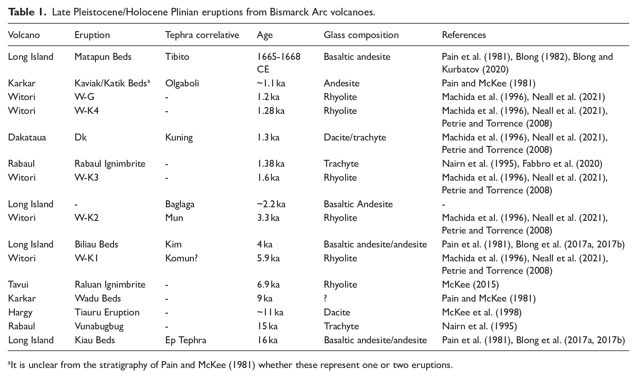
It is unclear from the stratigraphy of Pain and McKee (1981) whether these represent one or two eruptions.
All are caldera volcanoes, with calderas ranging in diameter from ~3 to 12 km. Estimates of eruption volumes have been hampered by limited mapping and widespread offshore deposition of erupted products, however they range between ~5 and 30 km3 (e.g. Blong, 1982; Machida et al., 1996; McKee et al., 2011).
Long Island and Karkar are the closest caldera volcanoes to the highlands (~200–300 km) and have traditionally been seen as the major sources of highland tephra beds (e.g. Blong et al., 2017b). The eruptive history of both volcanoes remains relatively poorly understood, although at least three major caldera forming eruptions have been identified at Long Island (Pain et al., 1981) and at least two at Karkar (Pain and McKee, 1981). Tephras from both volcanoes are basaltic andesite to andesite in composition (Blong, 1982; Schneider et al., 2017) and can thus be readily distinguished from the more evolved compositions of tephras from New Britain (Figure 2) (e.g. Neall et al., 2021). Magmas erupted from volcanoes in this segment of the arc also display tholeiitic affinities, with a pronounced enrichment in FeOT (total Fe assuming all iron is present as Fe2+) relative to MgO due to the delayed onset of magnetite crystallisation (Figure 2b). Volcanic glass from Long Island and Karkar share largely similar major element compositions but can be distinguished by differences in K2O. Glasses from Karkar have K2O contents <1.6 wt.%, while those from Long Island have K2O between 1.9 and 2.5 wt.% (Figure 2a).
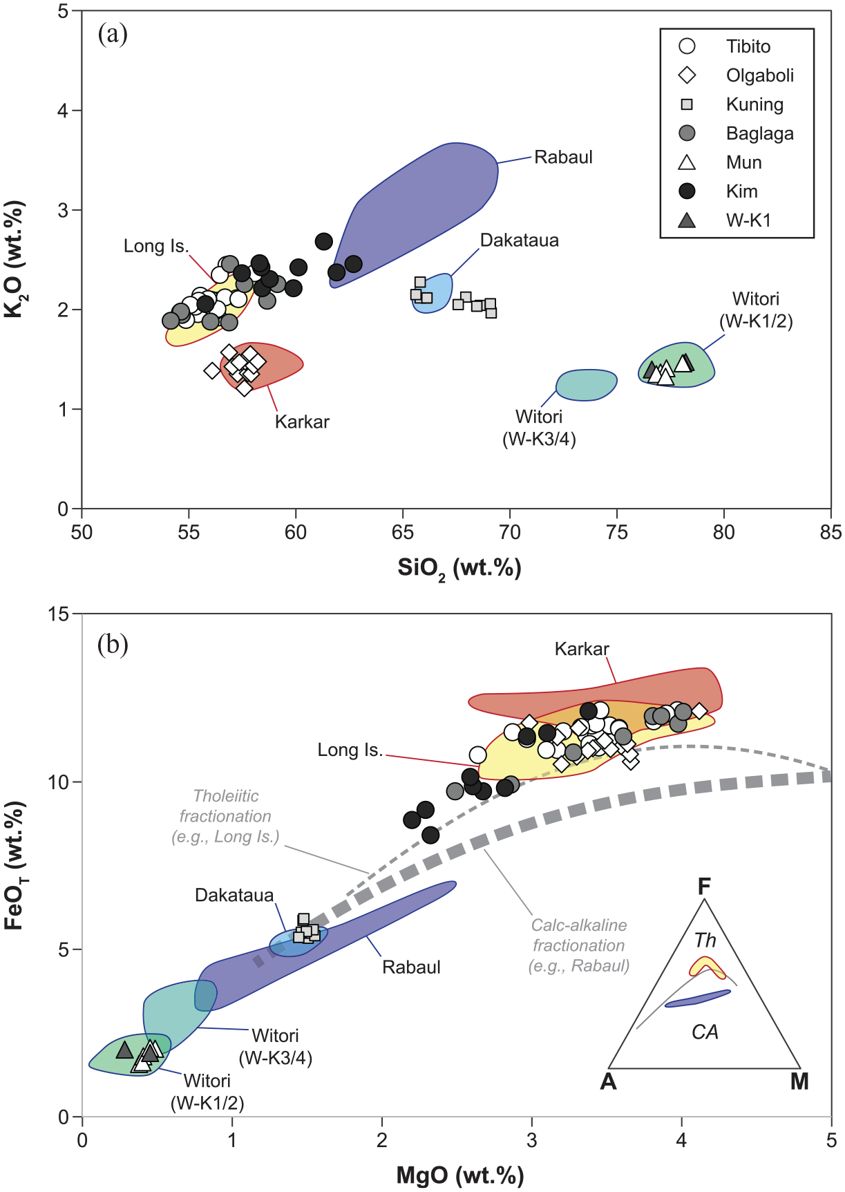
Comparison of volcanic glass compositions between highlands tephras and potential source volcanoes. Four distinct clusters in tephra composition can be seen when K2O is plotted against SiO2 (a), corresponding with eruption sources at Long Island, Karkar, Dakataua and Witori (note the compositional difference between the W-K1/W-K2 and W-K3/W-K4 eruptions). On the plot of FeOT versus MgO (b) tholeiitic tephras from the western Bismarck volcanoes (e.g. Long Island and Karkar) can be distinguished from calc-alkaline tephras from eastern New Britain (e.g. Rabaul) by their relative enrichment in FeOT (see inset alkali-Iron-Magnesium, AFM, diagram). Fields showing glass compositions for Rabaul, Dakataua, Witori, Karkar and Long Islands are based on data from Fabbro et al. (2020), Neall et al. (2021), and unpublished data available in the Supplemental Material. The calc-alkaline fractionation trend in (B) is from Bouvet de Maisonneuve et al. (2015) while the tholeiitic fractionation trend is from Firth et al. (2019).
Plinian eruptions from volcanoes in New Britain typically involve more evolved magmas, with glass compositions ranging from dacite to rhyolite (e.g. Fabbro et al., 2020; McKee et al., 2011; Neall et al., 2021). The eruption of Dakataua ~1300 year B.P. involved a magma with uniform dacitic glass compositions containing ~66.5 wt.% SiO2, 5.1 wt.% FeOT and 2.1 wt.% K2O (McKee et al., 2011; Neall et al., 2021). Nearby Witori volcano has experienced at least four major Plinian eruptions during the Holocene (W-K1, W-K2, W-K3 and W-K4), as well as numerous smaller Plinian events (Machida et al., 1996). All produced tephras with rhyolitic glass (Neall et al., 2021), however the older W-K1 and W-K2 events can be distinguished from more recent eruptions by their higher SiO2 (>75 wt.%) and lower FeOT (<2.5 wt.%) and MgO (<0.6 wt.%) (Figure 2b). The ~3.3 ka W-K2 event has been interpreted as the largest of these eruptions, with an estimated volume of ~30 km3 (Machida et al., 1996; McKee et al., 2011).
The geology of Hargy remains poorly studied although a caldera-forming eruption occurred ~11 ka. While analyses of pyroclastic material from this eruption are sparse, it is thought to have involved a rhyolitic magma with whole rock compositions containing ~70 wt.% SiO2 and ~1.2 wt.% K2O (McKee et al., 1998). Two major caldera-forming eruptions have occurred at Rabaul, the ~14 ka Vunabugbug eruption and the 1.4 ka Rabaul Ignimbrite eruption (Nairn et al., 1995). The intervening Raluan eruption at ~7 ka was also initially linked with Rabaul, however is now thought to have occurred at Tavui, a submarine caldera off the north-eastern tip of New Britain (McKee, 2015). Caldera-forming eruptions at Rabaul typically involve dacitic magmas that follow a calc-alkaline fractionation trend (Figure 2b). Mixing of multiple magma bodies at Rabaul leads to a greater diversity in glass compositions than is seen at other Bismarck volcanoes. For instance, in the Rabaul Ignimbrite glass SiO2 ranges between 60 and 69 wt.%, while K2O varies between 2.0 and 3.6 wt.% (Fabbro et al., 2020). Glass data for the Raluan ignimbrite are not available, however whole rock data indicates the magma involved with this eruption was more silica-rich (SiO2 >70 wt.%) and potassium-poor (K2O 1.5–2 wt.%) than that of the pyroclastic material from Rabaul (McKee, 2015).
While Holocene volcanism has been most intense along the Bismarck Arc, volcanic activity has also occurred within the PNG highlands and in Eastern Papua (e.g. Baldwin et al., 2012), although the eruption histories of many of these volcanoes remain poorly known. Relatively small, low volume Holocene eruptions may have occurred in the highlands at Birip and Yelia, however widespread tephras from highlands volcanoes (e.g. Mt Hagen; Mt Giluwe) are thought to be older than 200 ka (Pain, 2023). In eastern Papua, historical eruptions have occurred at Mt Lamington and Mt Victory (e.g. Jakeš and Smith, 1970), including the VEI4 eruption of Lamington in 1951 (Taylor, 1958). Tephras from Lamington extend ~150 km from the volcano (Ruxton, 1988). Glass compositions of tephras from both the highlands and eastern Papua volcanoes have not been analysed, however whole rock compositions are calc-alkaline to shoshonitic, with markedly higher K2O than magmas from the Bismarck arc volcanoes (e.g. Mt Hagen basalts contain 2.2 wt.% K2O – Mackenzie and Chappell, 1972; Mt Victory andesites contain 2–3.8 wt.% K2O – Jakeš and Smith, 1970; east Papuan rhyolites contain 3.4–4.7 wt.% K2O – Smith and Johnson, 1981).
The highlands tephra sequence
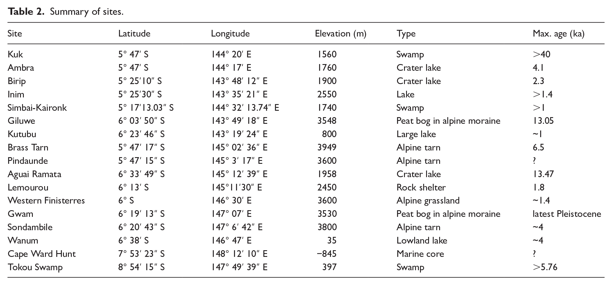
The tephra sequence from 17 sites across PNG is examined here (Figure 1). These sites have been sampled by various researchers over a 50-year period. We selectively focus on higher altitude sites (typically between 1550 and 4000 m a.sl.) as rapid tropical weathering (e.g. Chartres and Pain, 1984), and bioturbation mean few remnants of thin tephra survive at low altitudes. Nevertheless, a small number of lowland sites and a single marine core have also been included to widen the geographical distribution of sites. Tephra sequences have been sampled at archaeological excavations and from cores collected in peat swamps and lakes. The geomorphic environment of the sites varies, and includes alpine tarns, valley floors, agricultural sites and alpine to sub-alpine grasslands. The length of time recorded by individual sites also varies, although at least some sites (e.g. Kuk, Lake Gwam) are thought to preserve ⩾10 ka record. In this paper we have focussed on tephras emplaced during the last 4–5 ka. Sites are spread over a > 300 km east-west transect (Figure 1). Sites are summarised in Table 2 and a detailed description of each site is given in Supplemental Data File 1.
Summary of sites.
The tephra sequence has been most intensively studied at Kuk archaeological site (Figure 3), where at least eight Holocene tephras have been identified (Blong et al., 2017b). These vary in thickness from ~10 to 100 mm. In stratigraphic order the tephras, as described by Blong et al. (2017b) and Blong (2024), are:
Tibito: The youngest tephra, linked with the c.1665-68 CE eruption of Long Island (Blong and Kurbatov, 2020). At Kuk, this is present as an olive green, fine sand, forming a layer typically <50 mm thick. This tephra is composed of highly vesicular glass shards with plagioclase and pyroxene. This is by far the most studied tephra in New Guinea.
Kenta: A cream coloured, clayey sand of variable thickness, sometimes not present at all. Radiocarbon dates from Kuk suggest an age of 930–310 cal yr BP.
Olgaboli: A dark grey, silty sand up to 50 mm thick, composed of angular glass shards, plagioclase and minor pyroxene. Radiocarbon dates from Kuk and Ambra suggest an age of 1330–800 cal yr BP. Schneider et al. (2017) link this tephra with an eruption from Karkar volcano and refine the radiocarbon age estimate to 1180–980 cal yr BP.
Kuning: A thin bed of creamy white, clayey sand dated to 1690–930 cal yr BP.
Baglaga: A brown, fine sandy silt, typically < 20 mm in thickness. Radiocarbon dates suggest an age of 2700–1820 cal yr BP.
Mun: A gritty, creamy grey tephra up to 50 mm in thickness that contains abundant quartz. The age is estimated at 2733–2116 cal yr BP, although this age is based on a limited number of radiocarbon dates from soil horizons above the tephra (Blong, 2024).
Kim: A yellowish grey, fine sandy silt forming beds typically <20 mm thick. Minerals present include pyroxene and magnetite. Estimates put the age of this tephra at 4657–3618 cal yr BP.
Komun: A creamy white clay up to 70 mm thick, dated at 5990–6400 cal yr BP.
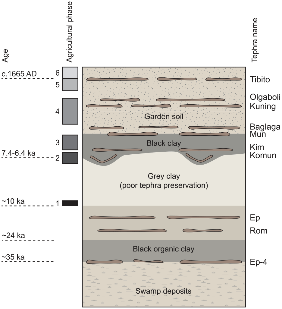
Composite stratigraphy for Kuk (not to scale), showing stratigraphic relationships of key tephras, with changes in soil type and agricultural phase. For more details about Agricultural phases see Golson et al. (2017). Modifed after Hughes et al. (2017).
A number of older tephras have also been identified, however the only one to be described in detail is Ep tephra, dated at 18 ± 2 ka (Blong, 2024). This is present as an olive-green sand, 20–50 mm thick (Blong et al., 2017b).
Geochemical data
To geochemically fingerprint PNG tephras, we have collated both published (Coulter et al., 2009; Schneider et al., 2017) and unpublished (e.g. Coulter, 2007; Torombe, 2006) tephra glass major element compositions. Data were collected using both wavelength dispersive (WDS) and energy-dispersive spectroscopy (EDS) on either electron microprobes or scanning electron microscopes. Analyses were run at four laboratories: Macquarie University, University of Edinburgh, Victoria University of Wellington and the Australian National University. Different standards were run at different laboratories (and not all standard data has been reported) making quantitative comparison of accuracy and precision difficult. Nevertheless, while some inter-laboratory variability is apparent, results from different studies generally overlap closely lending support to the reliability of the data (Supplemental Data File 2). Any variability was greatest for Na2O. Sodium-loss during electron microprobe analysis of volcanic glass is a commonly recognised issue and certain analytical conditions are usually employed to reduce this loss (e.g. defocussed electron beam, low beam current, early counting of Na, etc) (e.g. Hayward, 2012; Morgan and London, 1996). As analytical procedures differ between laboratories, the extent of Na-loss does vary between analyses. For this reason, Na2O is not considered as a discriminant in tephra comparisons here.
Analyses from each sample were screened to check for outliers (potentially representing mineral grains or shards of foreign tephras mixed by bioturbation or post-depositional remobilisation) by plotting K2O versus SiO2. As potassium is effectively incompatible in most silicate minerals (the exception being potassium feldspar, which is not reported in any volcanic rocks from the Bismarck Arc), it forms a linear array when plotted against an index of magma differentiation, such as SiO2. The slope of this array is influenced by the K2O content of parental magmas, which varies depending on the melt source of the magma (e.g. Johnson, 1976). Thus, glass from a single volcano should produce a linear array, defining the liquid line of descent, making it easy to identify anomalous analyses. Detailed examination of the chemistry of any data points that plotted away from this array was then undertaken. If an analysis was deemed to be sufficiently different from the remainder of the sample (and not simply reflecting natural variability) it was discarded (typically one or less analysis per sample). Samples that did not define a clear linear array were not used due to the possibility that tephras had been disturbed or mixed by bioturbation or remobilisation. All data were normalised on an anhydrous basis to ensure inter-comparability and then an average was calculated for each sample. Sample averages are reported in Table 3.
Mean composition of tephra samples.
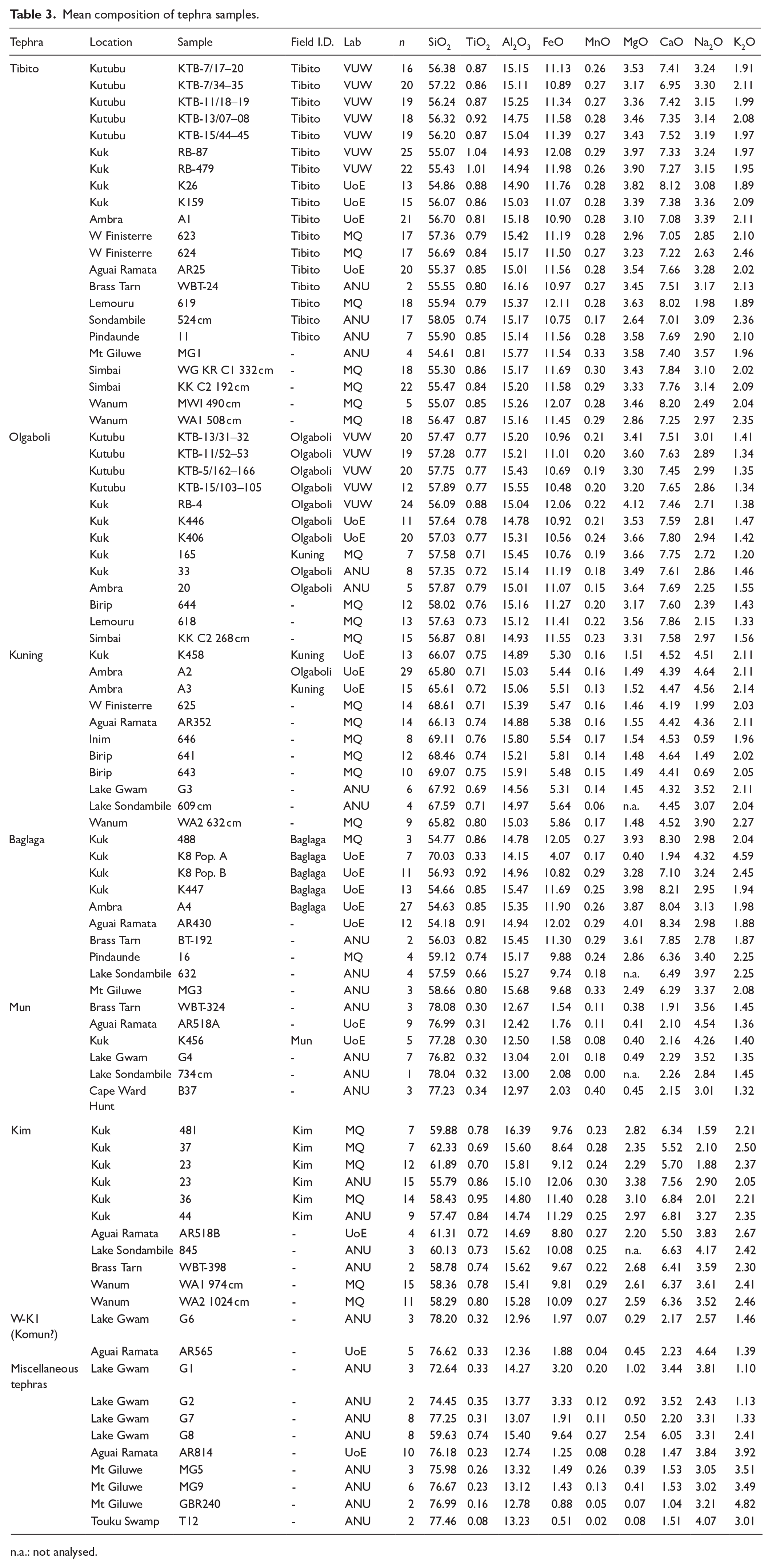
n.a.: not analysed.
Results
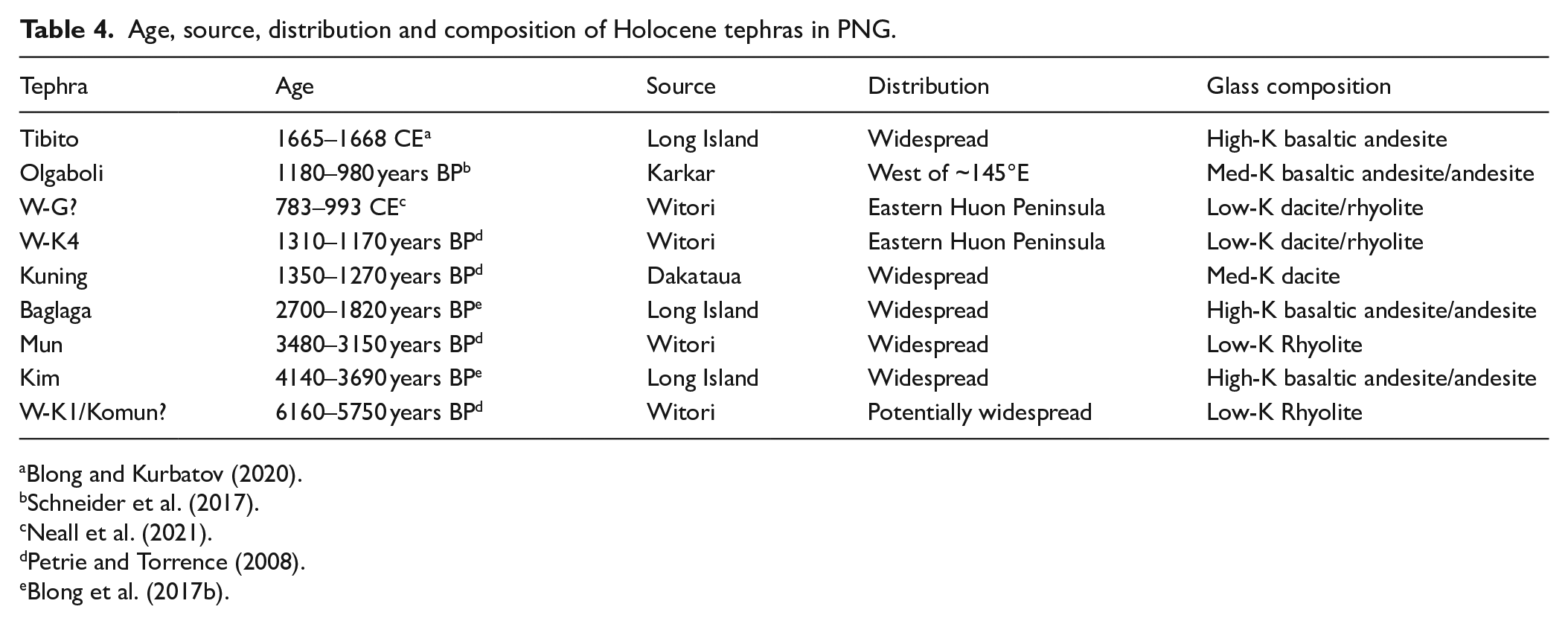
Geochemical data were collated for six key Late-Holocene tephras: Tibito, Olgaboli, Kuning, Baglaga, Mun and Kim. Each of these is described below, with details provided on composition, stratigraphy, occurrence, age and potential source volcano (Table 4). No samples from Kenta or Komun were available. At a number of sites additional tephras were identified that could not be correlated with the six tephras named above. These are described separately at the end of this section.
Age, source, distribution and composition of Holocene tephras in PNG.
Tibito
Tibito tephra is the youngest and most widespread tephra examined in this study. It is present at almost all sites, with the exception of Lake Gwam, Touku Swamp and Cape Ward Hunt (Figure 4a). Glass from the Tibito tephra is a basaltic andesite, with SiO2 content ranging between 54.6 and 58.1 wt.%, while K2O varies between 1.9 and 2.4 wt.% (Figure 2). This composition overlaps with that of glass from the Matapun Beds on Long Island, consistent with previous interpretations that Tibito was sourced from the most recent caldera-forming eruption on Long Island, believed to have occurred between 1665 and 1668 CE (e.g. Blong, 1982; Blong and Kurbatov, 2020).
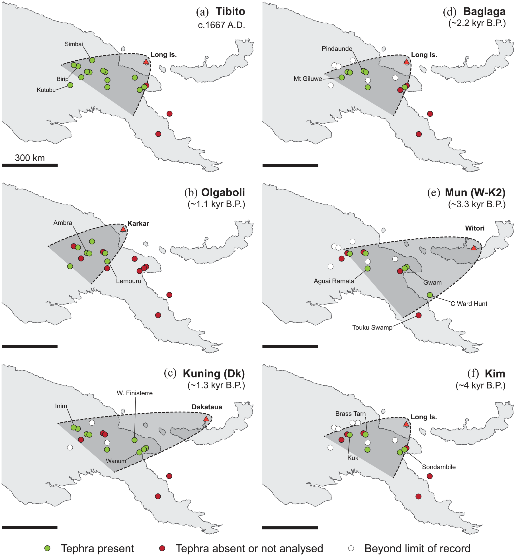
Maps showing the distribution and ages of six key mid-Late-Holocene tephras in the PNG highlands.
Olgaboli
Like Tibito, glass from Olgaboli is a basaltic andesite to andesite composition, with 56.0–58.2 wt.% SiO2. In many respects, Olgaboli is geochemically indistinguishable from Tibito, however the two tephras vary in their K2O content. The Olgaboli tephra glass contains <1.56 wt.% K2O (Figure 2a). The composition of Olgaboli is consistent with a source from Karkar volcano (Figure 2a), as previously suggested by Schneider et al. (2017).
Olgaboli is identified at seven sites, all in the central and western part of the highlands. This tephra is absent from sites in the eastern highlands and Saruwaged and Finisterre Ranges (Figure 4b). This is consistent with westward tephra dispersal from Karkar, adding weight to geochemical interpretations that Olgaboli is sourced from this volcano. Schneider et al. (2017) suggest an age of 1180–980 cal yr BP for the Olgaboli tephra.
Kuning
Kuning tephra glass is dacitic, with ~66 wt.% SiO2, ~5.4 wt.% FeOT and ~1.5 wt.% MgO (Figure 2). This differs from the more mafic composition of the overlying Tibito and Olgaboli tephras. Both Dakataua and Rabaul have erupted dactic pyroclastics, however Figure 2a shows that these vary in their K2O content. Kuning tephra glass contains ~2.1 wt.% K2O, consistent with the proximal pumice deposits of the Dk eruption at Dakataua (Neall et al., 2021). In most other major elements, Kuning also overlaps with the products of the Dakataua eruption (Figure 2b). The exception are a number of analyses with low Na2O (Table 3), however this is likely an analytical artefact. Because of Na-loss, SiO2 content becomes inflated during both analysis and normalisation and these samples appear to have SiO2 ~3 wt.% higher than the rest of the Dakataua and Kuning samples (Figure 2b).
Kuning tephra is present at nine sites, including the western Finisterres, Lake Gwam, Lake Sondambile, Wanum, Aguai Ramata, Kuk, Ambra, Birip and Inim (Figure 4c). Birip and Inim, where the tephra is present as a 1–2 cm thick bed, are >700 km from Dakataua.
Previous age estimates for Kuning tephra range from 1690 to 930 cal yr BP (Blong et al., 2017b). Correlation with proximal deposits of the Dk eruption allows this age to be refined. Radiocarbon dates on charcoal from pyroclastic flow deposits in New Britain suggest an age of 1350–1270 cal yr BP (McKee et al., 2011; Petrie and Torrence, 2008).
A single sample from Kuk (#165), identified in the field as Kuning, plots with Olgaboli tephra samples. In this sample analyses have been conducted on only a few grains, raising the possibility that bioturbation has mixed overlying Olgaboli tephra into this tephra bed. Alternately, this sample may have been misidentified.
Baglaga
The Baglaga tephra has been identified at Kuk and Ambra by Coulter et al. (2009). This tephra at both sites is compositionally identical to the Tibito tephra (glass containing ~54.6 to 57.0 wt.% SiO2, 10.8–11.9 wt.% FeOT, 1.9–2.5 wt.% K2O; Figure 2). A compositionally similar tephra in the same stratigraphic position is present at a further five sites (Mt Giluwe, Pindaunde and Brass Tarn on Mt Wilhelm, Aguai Ramata and Lake Sondambile). Across these sites this tephra varies in thickness, reaching >6 cm at Pindaunde. Baglaga has not been widely investigated previously, however these observations suggest that it is a regionally widespread tephra. Its composition and distribution is consistent with a Long Island source. Previous investigations of the proximal geology of Long Island have not identified an eruption of comparable age with this tephra (Pain et al., 1981).
Radiocarbon dates from Kuk and Ambra suggest an age of 2700–1820 cal yr BP for Baglaga, using samples collected from palaeosols above and below the tephra (Blong et al., 2017b; Denham et al., 2003; Sniderman et al., 2009). At Aguai Ramata uncalibrated radiocarbon dates above and below this tephra return ages of 2224 ± 47 and 2284 ± 40 14C yr BP respectively (Haberle, unpublished), while an age of 2040 cal yr BP is estimated from Brass Tarn (Supplemental Material). Comparison of re-calibrated radiocarbon ages between these sites (Supplemental Data File 3) suggests a most likely age of ~2100–2300 cal yr BP.
Mun
Glass in the Mun tephra is rhyolitic, with >76 wt.% SiO2 and <0.5 wt.% MgO. The low K2O content of this tephra (<1.5 wt.%) is consistent with the low-K array produced by glass from Witori. Neall et al. (2021) note that the more recent W-K3 and W-K4 eruptions from Witori produced magmas with lower SiO2 and higher FeOT than the older W-K1 and W-K2 events (Figure 2). The high SiO2 and low FeOT of Mun tephra correlate best with the composition of the earlier W-K1 and W-K2 events. Age constraints and stratigraphic relations, especially at Kuk and Aguai Ramata, suggest this tephra is part of the ~3.3 ka W-K2 eruption (Machida et al., 1996; Petrie and Torrence, 2008).
Mun has been identified at five sites including Kuk, Brass Tarn, Aguai Ramata and Lake Gwam (Figure 4e). A compositionally identical tephra is also present in a core collected in 845 m water depth off Cape Ward Hunt by the RV Sonne (Singura, 2015). While the age of this tephra is not constrained, it is likely Mun, however this cannot be conclusively proven. Glass shards from Mun have also been identified at Lake Sondambile; however, at this location they are mixed with compositionally different glass (with a Long Island composition) in a bed that shows physical evidence of reworking.
Kim
Kim is an andesitic tephra. Analyses of this tephra cover a wider compositional range than any other tephra examined in this study. SiO2 contents for Kim glass vary between 55.8 and 62.7 wt.%, while FeOT ranges from 8.4 to 12.1 wt.% (Figure 2). The less evolved examples of Kim tephra overlap with compositions of Tibito and Baglaga, consistent with a Long Island source. In Figure 2a, the more SiO2-rich samples fall within the compositional space of tephra from Rabaul; however, Figure 2b shows that this tephra has the pronounced iron-enrichment of tholeiitic glasses from the western Bismarck volcanoes, ruling out Rabaul as a potential source. Kim has traditionally been linked with an eruption at Long Island, mainly due to the similarity of estimated ages for this tephra based on samples from Kuk (3980–3630 cal yr BP; Denham et al. 2003: Table S2) and a single radiocarbon date from the penultimate pyroclastic sequence on Long Island (3990 14C yr BP; Polach, 1981). Geochemical fingerprinting confirms this link. Figure 4f shows that Kim has been identified at Brass Tarn, Aguai Ramata, Wanum and Lake Sondambile, as well as at Kuk. At Giluwe, a number of tephras with Long Island compositions are present, however intervening tephras like Olgaboli, Kuning or Mun are absent, and no age constraints are available, so while Kim is probably present there it cannot be confirmed.
Miscellaneous tephras
A number of individual tephras with unique compositions were also identified. The only site where any of these tephras could conclusively be correlated was Lake Gwam (Figure 5). This site preserves one of the longest tephra records examined here and is also the closest site to New Britain (Figure 1). Hence, a number of tephras from volcanoes in central New Britain are preserved at this site. The seven tephras recorded here include Kuning (G3) and Mun (G4), however a number of other tephras with a Witori-type, rhyolitic composition are also present. The two youngest tephras at this site, G1 and G2, are compositionally similar to each other, with ~72–75 wt.% SiO2, ~3 wt.% FeOT and ~1 wt.% K2O (Figure 5). Both overlap fields for post W-K2 magmas from Witori (Neall et al., 2021). Tephra G2 sits stratigraphically just above the Kuning tephra. McKee et al. (2011) note that there was insufficient time for soil formation between the Dakataua eruption and the W-K4 eruption. Thus, tephra G2 most likely correlates with the W-K4 eruption from Witori. This means that the tephra from the W-K3 eruption is not identified at this site, and leaves tephra G1 as most likely related with either the W-G, H1 or H2 eruptions of Machida et al. (1996). Neall et al. (2021) point out the difficulty of distinguishing tephra from these three events due to their compositional homogeneity. Of these three eruptions, Machida et al. (1996) suggest W-G was the largest, with an estimated eruption volume of 20 km3; however, the main ash dispersal axis is thought to have been to the SE.
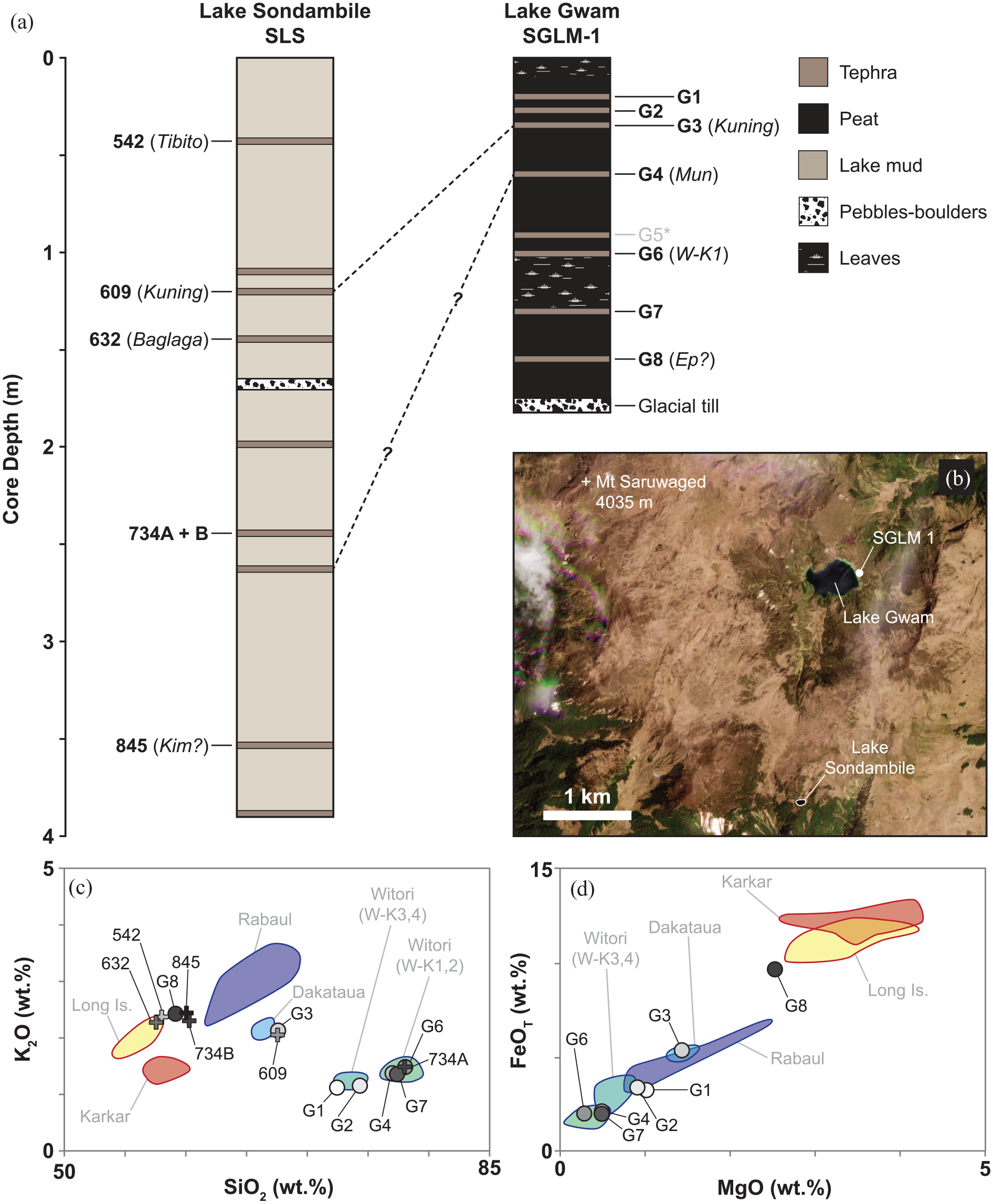
Comparison of tephras from Lake Gwam and Lake Sondambile in the Saruwaged Range. (a) Stratigraphic correlation between cores from Lake Gwam and Lake Sondambile. Analysed tephras are shown and where they have been named, the names are based on geochemical fingerprinting shown in panels (c and d). MgO was not analysed in the samples from Lake Sondambile, hence these samples are not shown in (d). Despite the high tephra preservation and close proximity (b), only one or potentially two tephras can be correlated between the two sites.
Three older tephras (>3–4 ka) are also present at Lake Gwam. Two of these, G6 and G7, are compositionally similar to the older Witori eruptions (i.e. high-Si rhyolites). The younger of these two tephras (G6), is >5050 14C yr BP, consistent in age with the ~5920 cal yr BP W-K1 eruption at Witori (Machida et al., 1996; Petrie and Torrence, 2008). A tephra from this eruption is also preserved at Aguai Ramata (AR565). The age of these tephras raises the question of whether they may also be a correlative of Komun tephra at Kuk, which has been dated to 6440–5990 cal yr BP (Denham et al., 2003: Table S2). Blong et al. (2017b) notes that Komun and Mun are often mistaken in the field and observes that quartz is present in both tephras; a feature consistent which a dacitic-rhyolitic composition. Unfortunately, no compositional data is available for Komun at Kuk, so a firm correlation cannot be made. The W-K1 eruption is the oldest documented eruption from Witori; however, Machida et al. (1996) note that the stratigraphy below this event is incomplete and suggest that the W-K1 eruption was not the first caldera-forming event at this volcano. Tephra G7 potentially represents an older, undocumented, eruption from this volcano. The final tephra in the Lake Gwam sequence is an andesitic to dacitic composition (Figure 5c and d) not dissimilar to that of Kim. This tephra is ~15 cm above a coarse gravel till interpreted as a late Pleistocene moraine, and hence is likely much older than Kim. Instead, it is possibly the 18 ± 2 ka Ep tephra, which has also been identified at Kuk (Blong, 2024; Blong et al., 2017b).
K2O-rich rhyolitic tephras (>70 wt.% SiO2, >3.5 wt.% K2O) have also been identified at a number of sites. A compositionally and stratigraphically similar tephra is present at the base of cores from both Aguai Ramata and Mt Giluwe (Table 3 – samples AR814 and MG9). Dates from both cores suggest a late Pleistocene age (16,484 cal yr BP at Aguai Ramata – Finn, 2012; >15,760 +320/-500 cal yr BP at Mt Giluwe – Sample GCB240, Barrows et al., 2011). Both sites are ~150 km apart, indicating that this may represent a regionally widespread tephra. Kuk and Lake Gwam are the only other sites that preserve such long tephra records, however this tephra has not been identified at either site. Blong et al. (2017b) note that tephras of this age are present at Kuk, however remain poorly known due to limited exposure. The source of this late Pleistocene tephra remains unknown, however the high K2O content of its glass (3.5–3.9 wt.%) implies a source in either the highlands or eastern Papua, rather than the Bismarck Arc. A second, compositionally similar tephra is present in two cores at Mt Giluwe (Table 3 – samples MG5 and GBR204). The latter tephra is much younger: in core GCB it sits 20 cm below Baglaga, while in core GBR it is bracketed by radiocarbon dates of 2800 and 4500 cal yr BP (G. Hope, unpublished). This tephra is absent from all other sites examined. It may represent a small volume eruption from a highlands volcano, however no such eruptions are currently known (Pain, 2023). A high-K2O dacitic glass has also been found mixed with Baglaga in a single sample from Kuk (Sample K8a). Compositionally similar tephras have not been identified elsewhere, limiting further interpretation, while the mixing of this sample with Baglaga raises the possibility that it has been remobilised from elsewhere in the stratigraphy. A core from Touku swamp, in the Owen Stanley Range (Figure 1), was examined to assess potential north-south extent of tephra distribution. No tephras associated with Bismarck Arc volcanos were identified in this core, however a single rhyolitic tephra (Sample T12 – Table 3) with an age of 4246–5660 cal yr BP was found. Given the proximity of this site to Mt Lamington (Figure 1) this tephra may represent a past eruption from this volcano.
Discussion
Tephra identification, preservation and distribution
Previously, much of the tephra identification in the highlands of PNG has relied on field characteristics and stratigraphic relationships. This was often hampered by the similarity in appearance of many tephras (Blong et al., 2017b). Geochemical fingerprinting has shown that in certain cases this has led to misidentification. At Kuk, sample #165 was identified in the field as Kuning, however the glass geochemistry of this sample clearly demonstrates that it is Olgaboli. Similarly, at Ambra, sample A2 has been identified as Olgaboli though its dacitic composition distinguishes it as Kuning (Table 3). These examples highlight the importance of geochemical fingerprinting in correlation between different sites.
Improved correlation afforded by geochemical fingerprinting raises questions about the preservation of thin tephras and the representativeness of individual tephra sequences. There is little overlap in the occurrence of tephras between cores from Lake Gwam and Lake Sondambile, despite the fact these two sites are only 2 km apart (Figure 5). Similarly, the tephra records from Pindaunde and Brass Tarn (<2 km apart) record significant differences (Table 3). At Birip, Walker and Flenley (1979) collected 16 cores across a ~200 m transect, spanning the lake and its marginal swamps. Of these, three cores recorded four tephras each, six cores recorded three tephras, two tephras were recorded in one core, four cores preserved only one tephra and in the remaining two cores no tephra layers were identified. Similarly, Blong et al. (2017a) collected 146 tephra short (40 cm) cores across a couple of hectares in the Western Finisterres. Tibito tephra was absent from 11.8% of these, with tephra thickness reaching >100 mm in the remaining cores. A number of reasons for such variable tephra preservation have been proposed, including thickness and type of vegetation cover, speed of burial/compaction and bioturbation (Blong et al., 2017a). The latter may be particularly pronounced at Kuk, where agricultural disturbance has continued throughout much of the Holocene (e.g., Denham et al., 2003). Depositional environment may also play a role. In the case of Lake Gwam, samples were collected by coring peat accumulated in a depression in a Pleistocene moraine, while at nearby Lake Sondambile, lake sediments were cored (Figure 5). Relative to the age of the record, a much higher number of tephras are preserved in the lake sediments of Sondambile than the peat at Lake Gwam. The Giluwe core was collected in a similar environment to that of Lake Gwam (small peat mire on a moraine) and also appears to preserve only a partial tephra record, with Olgaboli, Kuning and Mun absent despite their presence at nearby sites (Figure 4).
Tephras at a number of sites also show evidence of reworking. At Lake Sondambile, glass shards from Mun are present in a reworked layer (sample 734 cm), mixed with glass shards from another tephra with a Long Island composition. Similarly, at Aguai Ramata two populations of glass shards can be distinguished on the basis of their composition in sample AR518: one from Mun and a second from Kim. In both cases these samples demonstrate the presence of a tephra at that location (enabling tephra distribution to be determined), however additional information, such as tephra age or thickness, is lost.
Recognising the potential for absence of tephra horizons has a number of important implications. The absence of tephra from a single core at a single site does not necessarily imply that the tephra is not present in that region. This can be overcome by examining multiple cores at multiple nearby sites to better understand the regional distribution of a tephra layer. For instance, in the case of Lake Gwam and Sondambile, tephra sequences from both locations can be combined to form a composite sequence, given the close proximity of both sites. This composite sequence provides greater information, demonstrating the presence of >10 tephras deposited over the last ~13 ka (Figure 5).
Comparison between the 17 sites examined here shows that at least six regionally widespread tephras have fallen on the PNG highlands over the last ~4 ka (Figure 4). Tibito, Baglaga and Kuning are identified at the majority of sites across this region, demonstrating regionally widespread deposition. The older Mun and Kim tephras are also regionally widespread, however due to their age they are less frequently observed (either due to limited sampling or issues of preservation). Olgaboli is only present at sites in central and western highlands (Figures 4b and 6). This regional absence in eastern PNG suggests westward tephra dispersal that has not covered the entire region. This observation has implications for the stratigraphic interpretation of tephra sequences where geochemical fingerprinting has not been undertaken and underlying Kuning tephra may have been mistaken for Olgaboli.
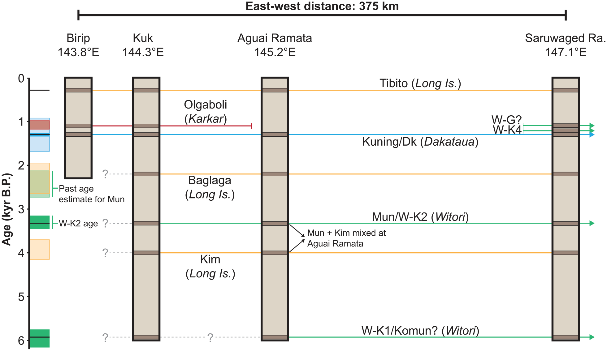
Chronology and distribution of key Late-Holocene tephras in the PNG highlands. Tephra stratigraphy is shown for four locations, spanning an east-west transect across the PNG highlands and Huon Peninsula. The Saruwaged Range stratigraphy represents a composite of cores from neighbouring Lake Gwam and Lake Sondambile. Arrows on the right of the figure denote tephras that are also found in New Britain. Age estimates for each tephra (Blong, 2024; Blong et al., 2017b; Petrie and Torrence, 2008; Schneider et al., 2017) are shown on the left of the figure, colour coded based on source volcano: Yellow – Long Island; Red – Karkar; Blue – Dakataua; Green – Witori. For Kuning and Mun tephras, refined ages resulting from correlation with well-dated proximal pyroclastics are shown with black lines denoting the best estimates of eruption age (Petrie and Torrence, 2008).
Kuning and Mun are the only Late-Holocene tephras from New Britain that are regionally widespread (although tephra from the W-K1 eruption may also be regionally widespread, but not commonly observed due to its age). Several other tephras from Witori, present at Lake Gwam, have not been identified at sites beyond the Saruwaged Range. Tephras from volcanoes in eastern New Britain (e.g. Rabaul, Tavui, Hargy) are absent from all sites examined in the highlands of PNG, although it should be noted that we have focussed on macroscopically visible tephra layers and cryptotephras from these eruptions may still be present.
Chronostratigraphy of PNG tephras
The age of Late-Holocene tephras in the PNG highlands is shown in Figure 6. The revised ages and refined geochemical fingerprinting of these tephras improves both the chronostratigraphy and reliability of the tephrochronology applied to archaeological and palaeoecological sites in the highlands, and potentially beyond. In the past, tephrochronology has been key for allocating ancient agricultural features, such as ditches and pits, to discrete phases at wetland archaeological sites in the highlands, such as at Kuk Swamp, as well as for correlating phases of wetland drainage between sites in the highlands (Denham, 2018; Golson et al., 2017).
For example, linking Kuning and Mun tephras with their source volcanoes has enabled the accuracy of age estimates for both tephras to be improved. This is most significant for Mun, which has previously had poor age constraints. Hughes et al. (2017) suggested an age of 2730-2120 cal yr BP based upon a limited number of radiocarbon dates from above the tephra at Kuk. Geochemical correlation of Mun tephra with the proximal deposits of the W-K2 eruption at Witori indicates that the date derived from Kuk is a significant underestimate of the tephra’s age (Figure 6), which has been placed at ~3315 cal yr BP (Petrie and Torrence, 2008). This earlier date has implications for understanding the inception of people using ditches to drain wetlands on the floors of the main highland valleys. The archaeological record for the onset of ditched drainage, referred to as Phase 3 (Hughes et al., 2017), is stratigraphically located between Kim and Mun tephras (Figure 3) (Denham, 2005; Denham et al., 2017). Consequently, the earliest ditch networks at Kuk post-date Kim tephra at 3980-3630 cal yr BP and pre-date deposition of Mun tephra at 3315 cal yr BP.
Like Mun, geochemical correlation of Kuning with the proximal deposits of the Dk eruption at Dakataua significantly reduces the uncertainty in age of this tephra. Blong et al. (2017b) place Kuning within the range 1690–930 cal yr BP based on radiocarbon dates from Kuk and Ambra. Bayesian statistical analysis of the radiocarbon dates from proximal deposits of the Dk eruption indicate an age of 1350–1270 cal yr BP (Petrie and Torrence, 2008). As yet, the tephrochronological significance of Kuning for reconstructing agricultural history in the highlands is unclear, however, it is likely to aid considerably in the temporal unpacking of successive drainage networks at Kuk that were used over the last 1500 years (Figure 3).
While Olgaboli, Baglaga and Kim tephras have been linked to source volcanoes at Karkar and Long Island, the eruptive history of both volcanoes remains poorly understood. Pain and McKee (1981) identified proximal pyroclastic deposits from two eruptions at Karkar that may be linked with Olgaboli. While the stratigraphically older of these is believed to represent a larger eruption, and thus is more likely associated with regionally widespread tephra fall, radiocarbon dates for both units cover a wide age range and overlap. The age range suggested for both eruptions spans 1430–730 14C yr BP (Pain and McKee, 1981). A detailed reappraisal of proximal volcanic deposits on Karkar is needed to further elucidate the timing and nature of Plinian eruptions from this volcano and may improve constraints on the timing of the Olgaboli tephra fall.
Similarly, with the exception of the most recent major eruption, the volcanic history of Long Island remains poorly understood. Pain et al. (1981) identify two major Late-Holocene eruptions from Long Island, which have been correlated (with differing degrees of certainty) with the Tibito and Kim tephras. Geochemical fingerprinting presented here suggests, however, that there have been at least three major eruptions from this volcano over the last ~4 ka. In the cases of both Baglaga and Kim, ball-park ages are known, however significant refinement remains possible.
Eruption frequency and magnitude
The abundance and high productivity of young caldera systems in the New Britain segment of the Bismarck Arc has previously been recognised by McKee et al. (2011). The identification of six widespread tephra horizons emplaced across the PNG highlands over the last 4 ka further reinforces this observation and extends it to include the volcanoes of the western Bismarck Arc as well. Previously, thin tephras such as Kuning, Mun and Baglaga had been interpreted as representing smaller (i.e. VEI 5) eruptions from Karkar or Long Island. Reinterpretation facilitated by the correlation and mapping presented here demonstrates that both Kuning and Mun were sourced from distant volcanoes in New Britain, while similarities in tephra distribution between Baglaga, Tibito and Kim imply that all three eruptions from Long Island may have been largely similar in size. These observations demonstrate that despite the comparatively small number of volcanoes in PNG, the frequency of high magnitude eruptions in this region makes it globally significant.
The magnitude of eruptions from Witori and Dakataua has previously been estimated from proximal sequences by Machida et al. (1996) and McKee et al. (2011). The W-K2 eruption has been recognised as the largest of the eruptions from Witori, with an estimated bulk volume of ~30 km3 (Machida et al., 1996). This is consistent with the widespread occurrence of Mun tephra from the W-K2 eruption across the highlands. Similarities in distribution and thickness of Mun and Kuning tephras suggests that both the W-K2 and Dk eruptions may have been comparable in size. The absence of tephras from younger Witori eruptions in all but the Lake Gwam sequence implies that the other Plinian eruptions from Witori (e.g. W-K4, W-G) involved smaller magma volumes, as suggested by Machida et al. (1996), although different dispersal axes cannot be ruled out. Tephra from the W-K3 eruption is absent from all sequences, indicating this eruption may have been smaller again (although a different ash dispersal direction cannot be ruled out). Lentfer and Torrence (2007) add weight to this with their observations from proximal sequences that sedimentary features of the W-K3 tephra are characteristic of slow accretion rates (and differ from the Dk or W-K2 tephras) and that no discernible damage to vegetation accompanied its emplacement. The identification of tephra from the W-K1 eruption as well as a pre-W-K1 eruption from Witori in the Lake Gwam sequence extends the eruptive history of Witori beyond what has previously been examined in proximal sequences by Machida et al. (1996). While tephra from the W-K1 eruption is also present at Agaui Ramata and may correlate with Komun at Kuk, it remains difficult to determine if this tephra is regionally widespread as few other analysed sites record the early Holocene record in sufficient detail. Nevertheless, the record from Lake Gwam demonstrates that at least five Holocene eruptions from Witori have distributed tephras >400 km from the volcano. This frequency of large Plinian eruptions must rank Witori as one of the most productive volcanoes on Earth.
Previous studies of tephra from Long Island have focussed heavily on the most recent, Tibito tephra eruption (e.g. Blong, 1982; Blong et al., 2018; Blong and Kurbatov, 2020). As noted earlier, the eruptive history of Long Island remains poorly understood. Correlation of Baglaga with a Long Island source demonstrates the presence of a previously undocumented Plinian eruption from this volcano. Observations of tephra distribution (Figure 4) and thickness indicate the eruption that produced Baglaga was comparable in size with the Tibito eruption: a tephra volume of ~12 km3 and thus larger than the 1883 CE eruption of Krakatau (Blong et al., 2018). Similarly, the ~4 ka eruption of Kim tephra, while previously linked with a Long Island source, was interpreted as being smaller than the Tibito eruption (Blong et al., 2018). Comparison of tephra distribution and thickness shows this too was likely similar in size with the later Tibito and Baglaga eruptions. Thus, Long Island has experienced three eruptions of at least VEI 6 over the last 4 ka.
Combined, these observations demonstrate that eruptions from the Bismarck Arc over the last 4 ka have been both more frequent and of higher magnitude than previously thought. Longer duration tephra sequences, such as Kuk or Lake Gwam, suggest that these updated frequency-magnitude relations indicated by the Late-Holocene tephra record are not unusual for the PNG region.
Conclusions
We have built upon the work of Coulter et al. (2009), Torombe (2006) and Schneider et al. (2017) to geochemically fingerprint and correlate regionally widespread Late-Holocene tephras in the PNG highlands. This provides a revised chronological framework for ongoing archaeological and palaeo-environmental studies (Figure 6) and a database for geochemical fingerprinting of Late-Holocene tephras in PNG. Six regionally widespread tephras have been emplaced over the past ~4 ka. Geochemical fingerprinting has allowed each to be linked with a source volcano. Three of these tephras are sourced from Long Island, demonstrating that this volcano has experienced repeated VEI 6 eruptions over this period. The remaining three tephras are the result of eruptions at Karkar, Dakataua and Witori volcanoes. The latter two examples demonstrate that tephras from volcanoes in New Britain can fall across the PNG highlands and raise the possibility that the eruptions responsible for these tephras were significantly larger than previously thought. In both cases, geochemical fingerprinting has enabled distal tephras to be linked with proximal pyroclastics, where robust radiocarbon dates have previously been obtained. In this way, the age constraints on both tephras has been significantly improved, allowing these tephras to be used as time stratigraphic horizons, improving comparability and precision in age-depth models at archaeological and palaeoecological sites.
Supplemental Material
sj-pdf-1-hol-10.1177_09596836241297678 – Supplemental material for Holocene tephras in the New Guinea highlands: Explosive volcanism in the Bismarck arc produces chronostratigraphic markers for interdisciplinary study
Supplemental material, sj-pdf-1-hol-10.1177_09596836241297678 for Holocene tephras in the New Guinea highlands: Explosive volcanism in the Bismarck arc produces chronostratigraphic markers for interdisciplinary study by Chris Firth, Russell Blong, Simon Haberle, Hugh Davies, Marisa Torombe, Sarah Coulter, Thomas Wagner, Shirley Lee, Lloyd Singura and Tim Denham in The Holocene
Supplemental Material
sj-xlsx-2-hol-10.1177_09596836241297678 – Supplemental material for Holocene tephras in the New Guinea highlands: Explosive volcanism in the Bismarck arc produces chronostratigraphic markers for interdisciplinary study
Supplemental material, sj-xlsx-2-hol-10.1177_09596836241297678 for Holocene tephras in the New Guinea highlands: Explosive volcanism in the Bismarck arc produces chronostratigraphic markers for interdisciplinary study by Chris Firth, Russell Blong, Simon Haberle, Hugh Davies, Marisa Torombe, Sarah Coulter, Thomas Wagner, Shirley Lee, Lloyd Singura and Tim Denham in The Holocene
Footnotes
Acknowledgements
Collection and analysis of thin tephras on the Papua New Guinea mainland has spanned more than 50 years. Our primary debt is to the late Jack Golson and to Phil Hughes for their roles in sorting out the tephrostratigraphy at the Kuk archaeological site in Western Highlands Province and to Colin Pain for leading RB on many tephra-hunting forays across the country. Our thanks also to the many cheerful highlanders who granted us access to their land, accompanied, and worked with us in remote places. We also thank the postgrad students, research assistants and laboratory technicians who performed microprobe analyses. The late Geoff Hope who cored lakes and peat bogs on several high mountains in PNG helped us immeasurably by writing up his field and lab notes into coherent and frequently revised documents which he made freely available to interested others. Our co-author Hugh Davies died a few days after commenting on the final draft manuscript. Hugh was known as the father of PNG geology - his formidable knowledge gained over six decades made him a giant in both academic and commercial mining worlds. He will be remembered not only for his public leadership, informing Papua New Guineans during events such as the 1994 eruption of Rabaul and the 1998 Aitape tsunami, but also for teaching and mentoring a generation of geology students at the University of Papua New Guinea. He gave so much back to the country where we have been privileged to conduct research.
Funding
The author(s) received no financial support for the research, authorship, and/or publication of this article.
Supplemental material
Supplemental material for this article is available online.
References
Supplementary Material
Please find the following supplemental material available below.
For Open Access articles published under a Creative Commons License, all supplemental material carries the same license as the article it is associated with.
For non-Open Access articles published, all supplemental material carries a non-exclusive license, and permission requests for re-use of supplemental material or any part of supplemental material shall be sent directly to the copyright owner as specified in the copyright notice associated with the article.