
Abstract
The Eldgjá eruption of ~ 939 AD is recognised as the largest in Iceland since Settlement, and ranks among the largest late-Holocene volcanic episodes on Earth. It disgorged > 21.0 km3 (Dense Rock Equivalent) of magma as lava flows (~ 19.7 km3) and tephra deposits (> 1.3 km3 DRE), comprising alternating phreatomagmatic (wet) and magmatic (dry) explosive phases. Tephra deposits up to four metres thick buried proximal areas, and extreme quantities of sulphur and other volatiles were released into the atmosphere. Little is known about the environmental and societal impacts of the eruption within Iceland as it took place during the initial decades of human settlement, and before written record-keeping in Iceland became prevalent. In this work, we review what is known of the Eldgjá eruption, making comparisons with the better documented Laki eruption of 1783–1784 AD (~ 15.1 km3 DRE). While the Eldgjá eruption was volumetrically greater, probably longer-lasting, and involved phreatomagmatic explosive phases, we reason that societal resilience to volcanic hazards was likely stronger in the 10th century compared with the 18th, reflecting differences in social and natural capital in Iceland. Accordingly, the impacts of the Eldgjá eruption cannot be inferred reliably from knowledge of the Laki episode and its aftermath.
Introduction
The two most voluminous basaltic flood-lava eruptions documented in Iceland during historical times are those of Eldgjá (~ 939 AD) and Laki (1783–1784 AD). Devastating impacts are associated with the 18th-century eruption, and the 10th-century event is thought to have been ~ 30% more voluminous, with nearly twice the SO2 yield (Thordarson and Self, 1993; Thordarson et al., 2001). However, written record-keeping was not established in Iceland during the initial century of widespread human settlement (after ~ 877 AD), and contemporary textual evidence from which to infer the impacts of the Eldgjá eruption is limited. In contrast, the Laki eruption elicited a rich body of eyewitness accounts and is discussed widely in the scientific literature. These accounts and studies provide abundant evidence for the substantial societal and demographic impacts linked widely to lava inundation, tephra fallout and volatile emissions accompanying the eruption.
Given the comparability (Table 1) of these flood-lava eruptions in terms of their geographical position, eruption magnitude and lava flow-field area, it is unsurprising that interpretation of the Eldgjá eruption has developed through the lens of the 18th-century ‘analogue’. Numerous authors have suggested that the Eldgjá eruption had substantial environmental and societal impacts. Larsen (2000) believed that it triggered the most extensive environmental changes since the Settlement of Iceland, while Dugmore and Vésteinsson (2012) argued that such flood-lava eruptions have catalysed irreversible and enduring environmental change on the island. Oppenheimer et al. (2018) reasoned that ‘the early colonists in the tenth century are unlikely to have fared better’ than late 18th-century Icelanders in terms of resilience to volcanic threats.
Comparison of various published eruption metrics from the Eldgjá and Laki flood-lava eruptions in Iceland.
Represents the timing of the magmatic phases whose ejecta were transported to and deposited in Greenland (the earlier phreatomagmatic phases may not be represented).
Our aim is to evaluate these arguments, taking account of diverse factors (e.g. volcanology, climatology, ecology, subsistence systems and governance) that could have fashioned the impacts and responses to these eruptions. This leads us to reassess the extent to which Laki helps us to understand the impacts of Eldgjá, and to identify scope for future research that could shed new light on the events set in motion by the Eldgjá eruption.
The Eldgjá fissure eruption: A review
The Eldgjá (English:
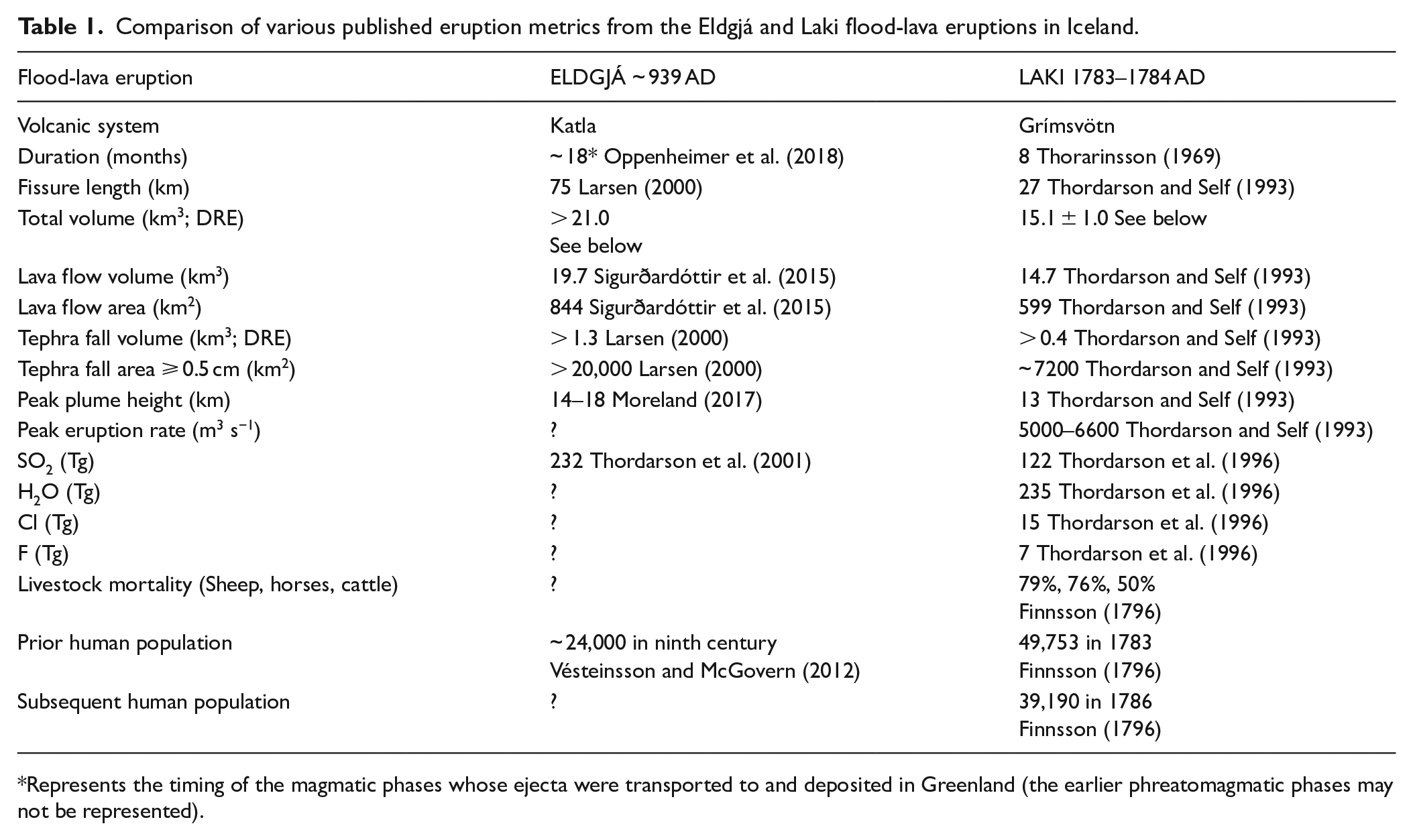
(a) Graphical representation of the magma output (km3) as lava flows for the two most voluminous Icelandic eruptions since Settlement: Eldgjá ~ 939 AD (Sigurðardóttir et al., 2015; Thordarson et al., 2001) and Laki 1783–1784 AD (Thordarson and Self, 1993). The location of the Katla and Grímsvötn central volcanoes is indicated. (b) Graphical representation of magma output (km3 as DRE) as tephra for the Eldgjá ~ 939 AD (Larsen, 2000) and Laki 1783–1784 AD (Thordarson and Self, 1993) eruptions. The location of the erupting fissure segments is indicated.
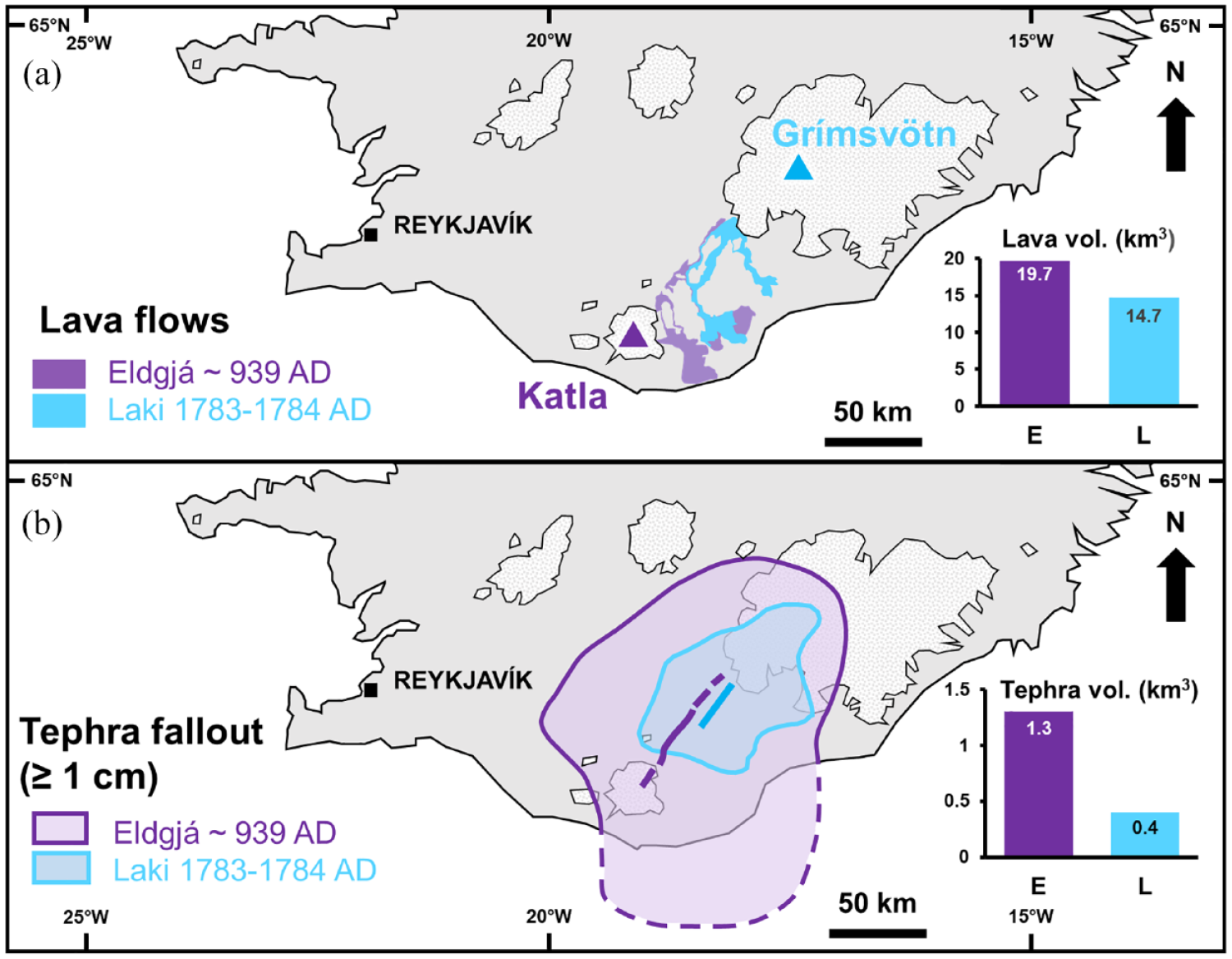
The lava flows (purple) and tephra fallout isopachs (greyscale) of the Eldgjá eruption in southern Iceland. Capitalised letters correspond to the locations pictured in Figure 3.
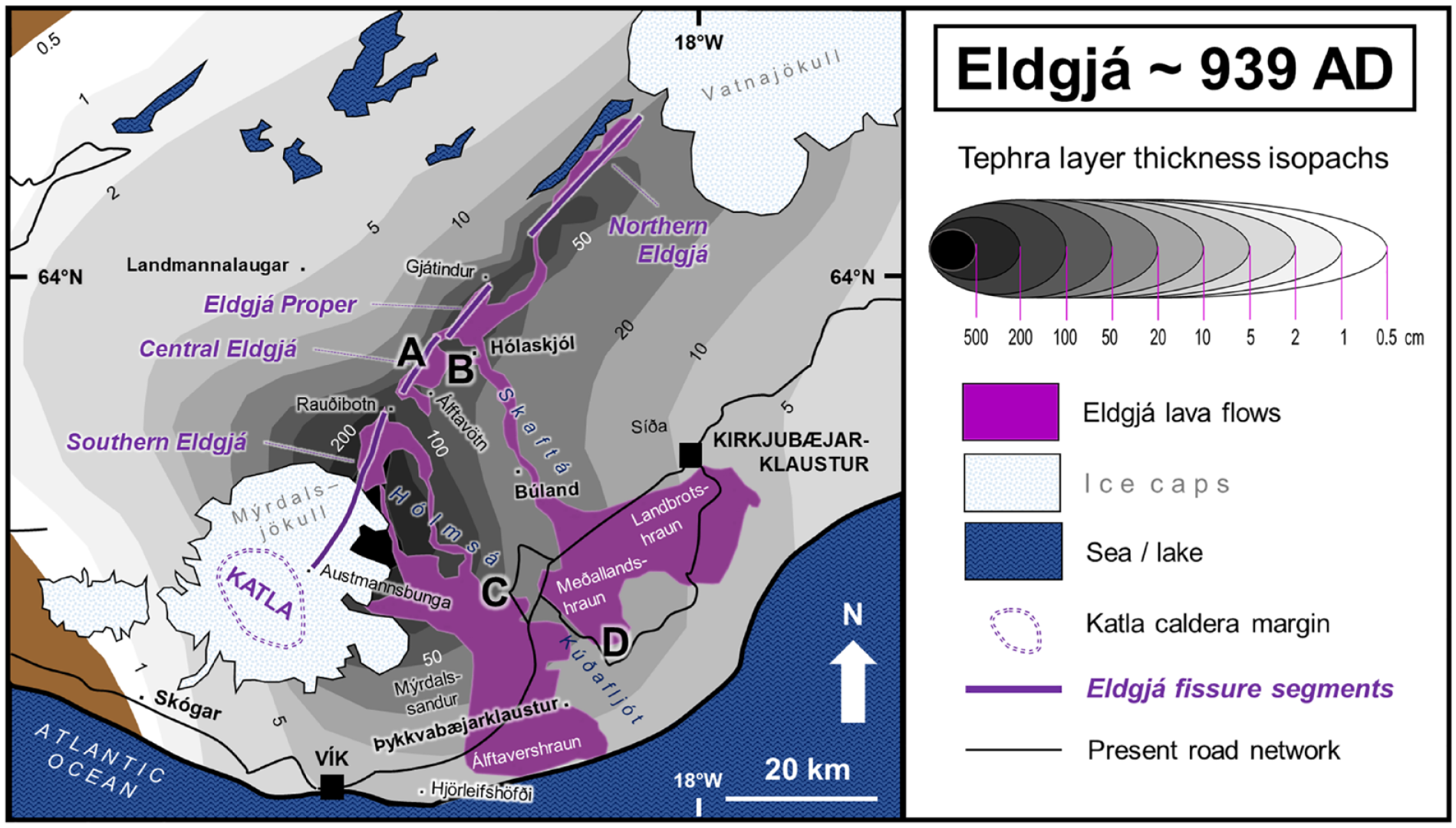
Four locations (indicated by the same capital letters as on Figure 2) on the Eldgjá lava flow fields. Flow direction is indicated by bold amber arrows, and the flow margins are indicated by dashed white lines. (a) Looking SW along a segment of Central Eldgjá into Crater M (
The Eldgjá eruption had discernible and enduring effects on Katla volcanic system. Based on the volume and frequency of proximal tephra layers, Óladóttir et al. (2008, 2018) identified that eruption frequency lowered from 5.6 per century (1150 BC to ~ 939 AD) to 2.0 per century (after ~ 939 AD). They proposed that pre-existing magma reservoirs may have been modified, forging a simpler, dyke-fed magma transfer system. Glacial meltwater floods also stopped emerging from the southern (Sólheimajökull) or western (Entujökull) caldera margins of Katla (Dugmore et al., 2000; Smith and Dugmore, 2006; Smith and Haraldsson, 2005). Sufficient subsidence of Katla would have been required to shift the Mýrdalsjökull ice divide, or its eruptive centres, so as to favour eastward flood routes through Kötlujökull during the last millennium (Larsen, 2000). The post-Eldgjá meltwater flood-routing has had lasting influences on human settlement to the east of Mýrdalsjökull (Larsen, 2000), not least because meltwater floods discharged during Katla eruptions can attain the highest recorded flow rates on Earth (e.g. 300,000 m3 s−1 in 1918; Tómasson, 1996).
Dating the Eldgjá eruption
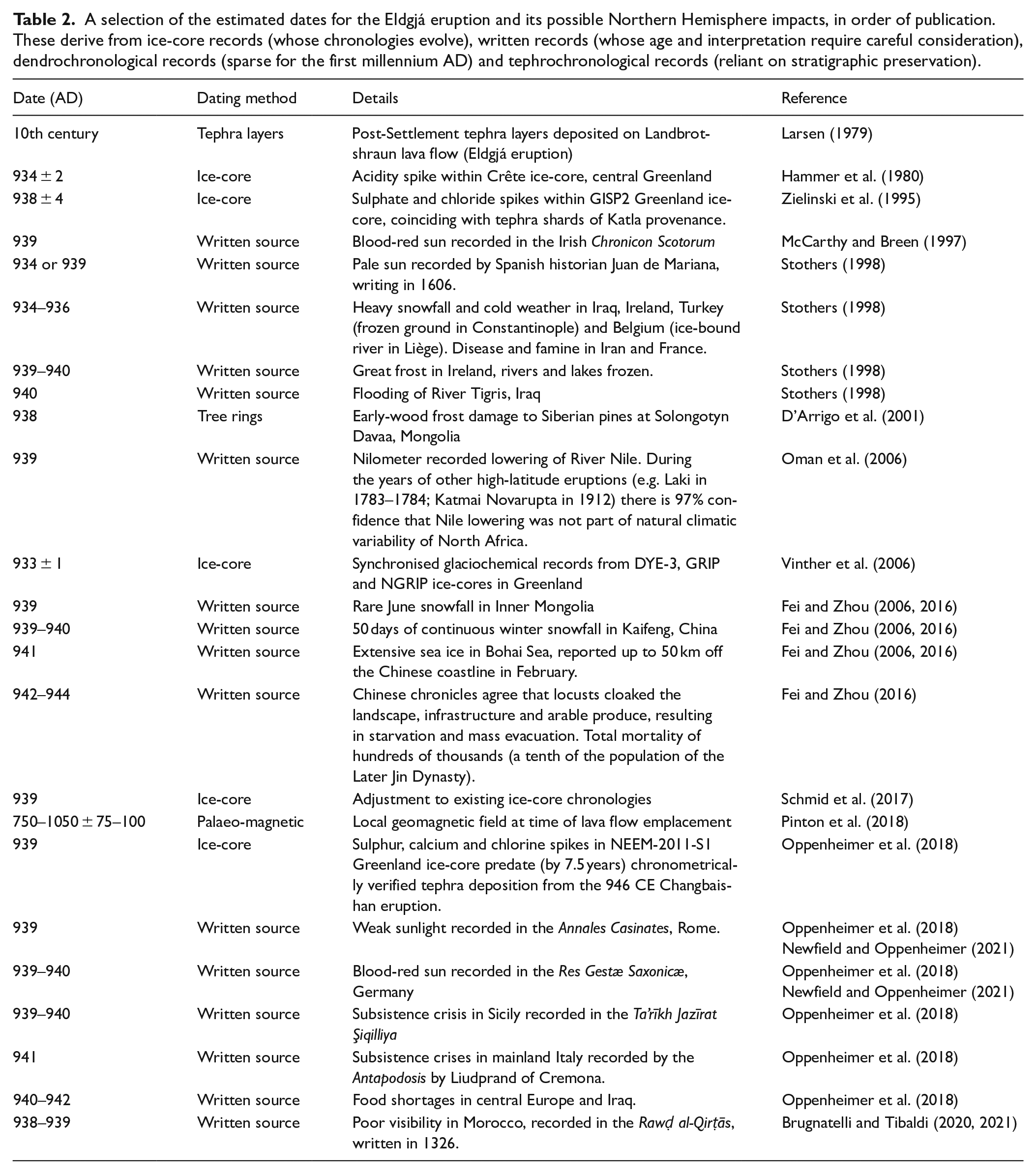
All published age estimates agree that the Eldgjá eruption commenced during the 930s AD (Table 2), though its precise timing and duration remain uncertain. This is primarily due to reliance on proxies (with their own uncertainties) for specific eruptive products; these having been emplaced or deposited during different eruptive phases (i.e. phreatomagmatic and magmatic) and by different means of transport. Nonetheless, the timing and duration are important parameters to constrain for the purposes of evaluating the volcanic impacts and for regional to hemispheric tephrochronology.
A selection of the estimated dates for the Eldgjá eruption and its possible Northern Hemisphere impacts, in order of publication. These derive from ice-core records (whose chronologies evolve), written records (whose age and interpretation require careful consideration), dendrochronological records (sparse for the first millennium AD) and tephrochronological records (reliant on stratigraphic preservation).
The earliest age constraint of the Eldgjá tephra layer (see ‘Tephra fallout’ section) is the Settlement of Iceland in the late ninth century (Larsen, 1979). The tephra layer overlies the so-called
Where physical and documentary evidence of volatile release (see ‘Volatile release’ section) can be identified and linked securely to Eldgjá, this enables the refinement of the chronology. Hammer et al. (1980) proposed that the eruption occurred in 934 ± 2 AD (Table 2), based on an acidity spike in the Crête ice-core of central Greenland. Zielinski et al. (1995) revised this to 938 ± 4 AD (Table 2), based on sulphate (SO42−) and chloride (Cl−) spikes in the GISP2 Greenland ice-cores that coincide with tephra shards of Eldgjá provenance. However, they could not explain why the Cl− peak lagged behind the SO42− peak. Both estimates relied on the established ice-core chronologies. Vinther et al. (2006) addressed the possibility of counting bias by synchronising three ice-core records (DYE-3, GRIP and NGRIP) and proposed 933 ± 1 AD (Table 2) for two reasons. The first was based on the strong seasonality of δ18O in ice-cores, whose variations are associated strongly with air temperature. Secondly, they investigated counting bias between two (tephra shard) isochrons that (they argued) originated from eruptions at Vesuvius in 79 AD and Öræfajökull in 1362 AD. In their 1282-year test period, Vinther et al. (2006) counted a single (erroneous) extra year (hence their ~ 0.1% uncertainty). However, the volcanic marker attributed to Vesuvius derives instead from an unknown source in 88 AD (e.g. Plunkett et al., 2022), thereby undermining the chronological arguments of Vinther et al. (2006).
McCarthy and Breen (1997), drawing attention to a blood-red sun reported in the Irish
Lava flow field
The lava flows, which exhibit pāhoehoe (Íslenska:
Southern Eldgjá
‘Southern Eldgjá’ (
When in its insatiable greed this most cruel fire had destroyed this land and all that was in it, then it yielded a still more terrible marvel for it invaded the sea on the shore. And when it reached the deep sea, it began to burn and consume the water with unheard-of fury right down to the depths. (Cited in Thorarinsson, 1967:27)
Written material that can be linked convincingly to this eruption is sparse because it occurred during Iceland’s pre-literate period. Nordvig (2019) suggested that Stanza 51 of
Surtr ferr sunnan | með sviga lævi, | skínn af sverði | sól valtíva; | grjótbjǫrg gnata, | en gífr rata, | troða halir helveg, | en himinn klofnar. (Kristjánsson and Ólason, 2014:304)
Comes Surt from the south with the singer-of-twigs, the war-god’s sword like a sun doth shine; the tall hills totter, the trolls stagger, men fare to Hel, the heavens rive. (Hollander, 1928:13)
Surt comes from the south with the harm of branches, the sun of the slaughter-gods glances from his sword; the rocky cliffs crack open and the troll-women are abroad, men tread the road to hell and the sky splits apart. (Larrington, 1996:11)
Most inferences about the appearance of the 10th-century landscape come from the
. . . áðr jarðeldr rann þar ofan, en þá flýðu þeir vestr til Hǫfðabrekku ok gerðu þar tjaldbúðir, er heitir á Tjaldavelli. (Benediktsson, 1986:330)
But then these lands were covered by a lava-flow, and people fled west to Hofdabrekka, where they pitched their tents at a place called Tjaldavoll. (Pálsson and Edwards, 1972:125)
Larsen (2010) published a reconstruction of Mýrdalssandur as it may have appeared before the 10th century. She considered that the oceanfront was then situated farther inland (now ~ 20 m a.s.l.) near Hjörleifshöfði (Figure 2). The
. . . þar var þá vatn mikit ok álptveiðar á. Molda-Gnúpr seldi mǫrgum mǫnnum af landnámi sínu, ok gerðisk þar fjǫlbyggt. . . (Benediktsson, 1986:330)
. . . at that time, there was a large lake there, a fine place for hunting swans. Molda-Gnup sold a good many people parts of his land-claim, so the district became thickly populated. (Pálsson and Edwards, 1972:125)
Stratigraphic sections in the periphery of the lava flows contain tephra layers that pre-date the Eldgjá eruption (Larsen, 1979), indicating sufficient vegetation cover in Álftaver to subsume those deposits. According to the
Central Eldgjá
‘Central Eldgjá’ and ‘Eldgjá Proper’ (
After a 3 km break between Rauðibotn and Svartahnjúksfjöll, the Eldgjá fissure continues for 9 km in a series of canyons along the western side of Álftavötn valley (Figures 2 and 3a; Miller, 1989; Robson, 1956). The ‘Eldgjá proper’ segment is offset from ‘Central Eldgjá’ by 1.5 km, and trends northeast for 8.5 km to Gjátindur through a pre-existing chasm that now contains the waterfall Ófærufoss (Figure 2; Miller, 1989; Robson, 1956).
Northern Eldgjá
‘Northern Eldgjá’ (
Tephra fallout
Distribution, grain-size and geochemical characteristics
Whilst lava effusion was the dominant eruption style (Figure 1), the capability of such flood-lava eruptions to generate voluminous tephra deposits is often overlooked (Houghton and Gonnermann, 2008). The isopach map of the Eldgjá tephra layer was produced by Larsen (1979, 2000), who calculated its terrestrial volume to be > 1.3 km3 (DRE; Dense Rock Equivalent). It is one of the most voluminous tephra layers to have been deposited in Iceland during historical times (Figures 1b and 2). The preserved thickness of the layer exceeds four metres in the upper Hólmsá river valley, and an area > 20,000 km2 was covered by a layer ⩾ 0.5 cm (Figure 2; Larsen, 2000). Isopach maps have been produced for nine of > 16 distinct units of tephra fallout (e.g. Moreland et al., 2019; Figure 4). Estimated volumes of these units range from 0.002 km3 DRE (Unit 6) to 0.091 km3 DRE (Unit 5) (Moreland, 2017). Furthermore, the eruption sequence has been reconstructed from this tephrostratigraphy. The onset of the eruption (Phase 1; Figure 4) was a phreatomagmatic (wet) phase that originated beneath Mýrdalsjökull in the ‘Southern Eldgjá’ segment. Such wet explosive activity is associated with several later phases (e.g. 5, 8 and 10; Figure 4), but these were interspersed with magmatic (dry) phases (e.g. 2, 7 and 9; Figure 4) originating from subaerial segments in ‘Southern Eldgjá’. Explosive activity in the ‘Central’ to ‘Northern Eldgjá’ segments (e.g. Phase 11) was entirely dry, though the tephra fallout units are often preserved poorly in the regional stratigraphy (Moreland, 2017).
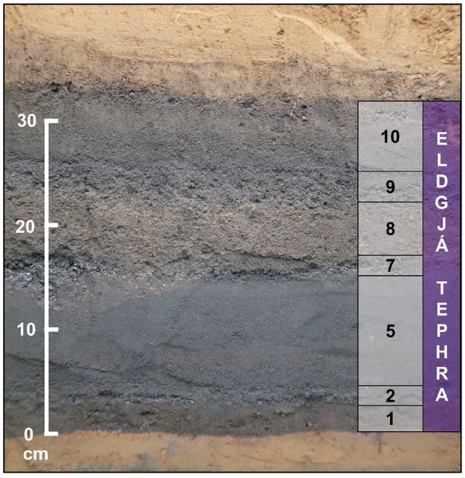
Profile of the Eldgjá tephra layer, which has a mean thickness of 34 cm at this site (63.78024°N; 18.51078°W; 17 km from the fissure) near Búland, Skaftártunga (Figure 2). The fallout units (seven at this site) represent the discrete eruptive phases, which are numbered following Moreland et al. (2019).
Detailed textural analysis of the tephra from the phreatomagmatic and magmatic phases showed that the grains’ surface appearance (i.e. dull versus shiny) and grain-size distributions are discernible differences between the two (Moreland et al., 2019). The phreatomagmatic units are also more cohesive and contain generally poorly sorted, bimodal, fine ash-grade tephra in the 5–25 km sector (Moreland et al., 2019). The magmatic units are less cohesive and contain generally very well- to well-sorted, unimodal, and ash- to lapilli-grade tephra in the 5–25 km sector (Moreland et al., 2019). Estimated eruption plume heights attained during Phase 7 (magmatic) and Phase 8 (phreatomagmatic) are similar (14–18 km), indicating that both phases had strong sub-Plinian to weak Plinian intensities (Moreland, 2017). The interaction of magma with external water influenced the grain-size distribution of the tephra deposits, and had little to no influence on the explosive intensity of the wet eruptive phases (Hajimirza et al., 2022; Moreland, 2017; Moreland et al., 2019).
Around 99.5% of the Eldgjá eruptives are transitional alkali basalts (Table 3), but some samples from ‘Northern Eldgjá’ have a tholeiitic component, with relatively lower titanium (TiO2 ≈ 2.4 Wt. %) and potassium (K2O ≈ 0.3 Wt. %) contents (Thordarson et al., 2001). This suggests that, in the north-eastern extreme of Eldgjá, there is genetic overlap between magma erupted from Katla and Grímsvötn volcanic systems (Miller, 1989). Alternatively, the tholeiitic component may represent a contaminant that was incorporated inside the conduit or introduced by reworking on the surface.
Composition of major and minor oxides comprising the Eldgjá tephra layer, as reported by multiple sources.
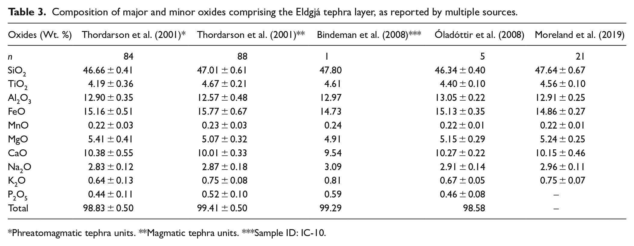
Phreatomagmatic tephra units. **Magmatic tephra units. ***Sample ID: IC-10.
Impacts of tephra fallout
No written accounts of tephra fallout or its impacts have been identified. Nordvig (2019) highlighted explicit references to
. . . snýsk Jǫrmungandr | í jǫtunmóði; | ormr knýr unnir, | en ari hlakkar, | slítr nái neffǫlr, | Naglfar losnar. (Kristjánsson and Ólason, 2014:303)
The Mithgarth-worm in mighty rage scatters the waves; screams the eagle, his nib tears the dead; Naglfar loosens. (Hollander, 1928:12)
The great serpent writhes in giant rage, the serpent churns the waves, the eagle shrieks in anticipation, pale-beaked he tears the corpse, Naglfar breaks loose. (Larrington, 1996:10)
However, texts purported to contain geomythical references, but which are composed in subsequent centuries, are not convincing evidence of impact. In any case, the alternative English translations by Hollander (1928) and Larrington (1996) show that there is considerable room for interpretation of these medieval texts.
The
Pagan graves confirm that there was a pre-1000 AD (Christianisation) human presence in Skaftártunga. One of the burials in Hrífunes (Eldjárn, 1984; Gestsdóttir et al., 2015; Gestsson, 1984; Larsen and Thorarinsson, 1984; Magnússon, 1984) confirms occupation before the Eldgjá eruption. However, besides the pagan burial at Hrífunes and the geomythology of Settlement, no further evidence of pre-Eldgjá construction has yet been identified in Skaftártunga.
Skaftártunga lies entirely within the 25 cm isopach (Figure 2) but, despite tephra deposits > 25 cm thick tending to prompt farm abandonment in Iceland (e.g. Thorarinsson, 1979), the archaeological record suggests that the converse occurred. Archaeological trenches have revealed that new structures were built directly onto the surface of the Eldgjá tephra deposit (Hreiðarsdóttir, 2020; Hreiðarsdóttir and Þórsdóttir, 2014; Hreiðarsdóttir et al., 2014, 2015, 2024) at sites where the layer is 40–100 cm thick. These are the earliest known evidence for permanent settlement in Skaftártunga. Evidence for construction above the Eldgjá deposit was also observed east of the river Skaftá near Leiðólfsfell (Einarsson, 2010b), at sites where the layer is ~ 40 cm thick. Farther east, archaeological investigations in the Síða foothills found that the earliest evidence for construction likewise post-dates the Eldgjá eruption (Einarsson, 2008, 2010a, 2012, 2013, 2014, 2015) at sites where the layer is ~ 10 cm thick. Therefore, the apparent development of the tephra-covered highland margins after the eruption may indicate an evacuation of the early population from the lowlands (which had been invaded by lava flows) towards the tephra-mantled wastes of the foothills.
Volatile release
Early estimates of the volatile yield from the Eldgjá eruption were derived from analyses of ice-cores from the Greenland Ice Sheet. The sulphur dioxide (SO2) yield to the atmosphere was estimated to be 165 Tg (Hammer et al., 1980) and 93 Tg (Zielinski et al., 1995). A more recent estimate of the stratospheric sulphur yield from the eruption is 16.2 Tg (double this value for equivalent SO2; eVolv2k database, reported by Toohey and Sigl, 2017).
Measuring volatiles within crystal-hosted glass inclusions and matrix glass, the initial petrological analyses of the Eldgjá tephra estimated a total SO2 yield to the atmosphere of 55 Tg (Palais and Sigurdsson, 1989), though subsequent reassessments of the total magmatic volume would rescale that value. Additionally, Thordarson et al. (1996) proposed that ~ 80% of the total sulphur emission from such eruptions (based on Laki) is released from plumes during explosive phases. This ‘vent’ component, which can breach the tropopause, may reside in the stratosphere for weeks and result in widespread dispersal across the Northern Hemisphere. The remaining ~ 20% is degassed from cooling lava flows, generating tropospheric hazes with more rapid wet deposition of volatile constituents. The ‘lava’ component of degassing had been neglected in the original volatile yield estimates (i.e. Hammer et al., 1980; Zielinski et al., 1995). Therefore, this two-stage volatile budget was evoked subsequently to estimate the total sulphur emissions from eruptions of Katla, Grímsvötn and Veiðivötn-Bárðarbunga volcanic systems (Thordarson et al., 2003b). Amidst other volatile components (Table 1), the estimated total SO2 yield to the atmosphere was raised to 232 ± 18 Tg, encompassing a ‘vent’ component of ~ 184 ± 32 Tg and a ‘lava’ component of ~ 35 ± 16 Tg (Thordarson et al., 2001).
Discrepancies between these estimates reflect uncertainties associated with upscaling glaciochemical and petrological data to reconstruct the dispersal and volatile loading of volcanic plumes. Petrological estimates for Eldgjá are limited by uncertainty of the eruption magnitude (i.e. the unquantified volumes of ultra-fine tephra deposited offshore and overseas, tephra reworked after deposition and lava buried after emplacement). Meanwhile, early ice-core estimates (i.e. Hammer et al., 1980; Zielinski et al., 1995) were based on radionuclide (e.g. 90Sr) deposition resulting from Soviet atomic bomb tests. Atomic weapons inject radionuclides into the stratosphere essentially instantaneously. However, plumes from basaltic flood-lava eruptions may be episodic, with emissions being potentially confined to the troposphere for months to years (Thordarson et al., 2001). In the case of the prolonged activity of Eldgjá, where volatiles were likely scavenged within the troposphere during phreatomagmatic phases, faithful reconstruction of volatile emission using distal ice-core deposits seems unlikely.
Proximal impacts of emissions
Whilst no written accounts of volcanic emissions or their impacts have been identified, Oppenheimer et al. (2018) suggested that Stanza 57 of
[Sól] tér sortna, | sígr fold í mar, | hverfa af himni, | heiðar stjǫrnur; | [ge]isar eimi | ok aldrnari, | leikr hár hiti | við himin sjálfan. (Kristjánsson and Ólason, 2014:315)
The sun turns black, earth sinks into the sea, the bright stars vanish from the sky; steam rises up in the conflagration, a high flame plays against heaven itself. (Larrington, 1996:11)
Distal impacts of emissions
Tree ring reconstructions reveal a Northern Hemisphere summer cooling in 940 AD, which has been attributed to a volcanic aerosol forcing of ~ 0.7°C to ~ 1.5°C (Oppenheimer et al., 2018). Assorted historical sources from Europe (McCarthy and Breen, 1997; Oppenheimer et al., 2018; Stothers, 1998), Asia (Fei and Zhou, 2006, 2016), the Middle East (Stothers, 1998) and northern Africa (Brugnatelli and Tibaldi, 2020; Oman et al., 2006) recorded anomalous optical effects in the atmosphere, food shortages and abandonments during the 933–944 AD period (Table 2). However, given the uncertainties in interpreting Early Medieval texts, their association with volcanic emissions must be cautionary (Supplementary Information; Brugnatelli and Tibaldi, 2021; Newfield and Oppenheimer, 2021). Some of the distal phenomena identified by Stothers (1998) occurred years before 939 AD (i.e. the year sulphate was deposited in Greenland). Such phenomena (see Table 2) may have been dated insecurely, attributed erroneously to Eldgjá, or associated instead with unrelated climatic variability. Alternatively, these phenomena may relate to the impacts of earlier activity at Eldgjá that has not been detected in glaciochemical datasets, or even to eruptions elsewhere.
The Laki fissure eruption
The widely referenced ‘analogue’ to Eldgjá is the Laki (originally
The lava flows (light blue) and tephra fallout isopachs (greyscale) of the Laki eruption. Capitalised letters correspond to the locations pictured in Figure 6.
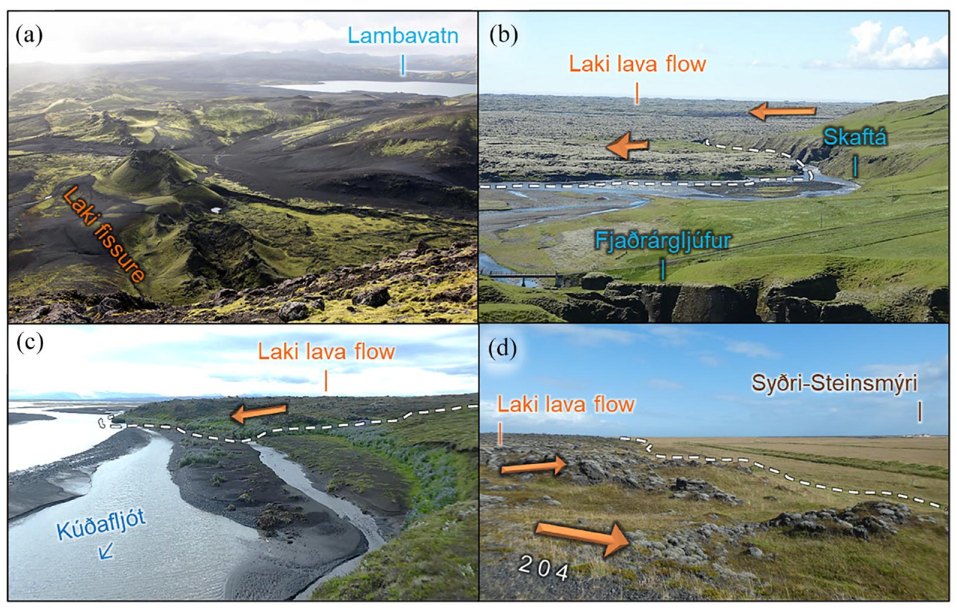
Four locations (indicated by the same capital letters as on Figure 5) across the Laki lava flow field. Flow direction is indicated by bold amber arrows and the flow margins are indicated by dashed white lines. (a) Looking SW from Laki proper along the south-western segment of the Laki fissure. (b) The Laki lava flow now overlies earlier lava from Eldgjá as it exited the Skaftá river valley and spread across the lowlands. (c) The flow front of the Laki lava flow where it forms the eastern banks of the river Kúðafljót. (d) Route 204 drops off the flow front of the Laki lava flow near Syðri-Steinsmýri.
The Laki eruption, or Skaftá Fires (Íslenska:
The tholeiitic basalt was extremely homogeneous (Sigmarsson et al., 1991; Thordarson and Self, 1993) and relatively primitive in composition (e.g. SiO2 ≈ 49.6 Wt. %; MgO ≈ 5.7 Wt. %; FeO ≈ 13.5 Wt. %; Thordarson et al., 1996). Estimates for volatile emission include ~ 122 Tg of sulphur dioxide, ~ 235 Tg of magmatic water, ~ 15 Tg of chlorine and ~ 7 Tg of fluorine (Thordarson et al., 1996). Fluorine concentrations were > 600 ppm in glass inclusions and > 400 ppm in matrix glass (Thordarson et al., 1996). The stratospheric aerosol burden was assessed as 25–30 Tg (Thordarson and Self, 2003), and glaciochemical work in Greenland yielded a comparable value for sulphur of 20.8 Tg (Toohey and Sigl, 2017).
The cooling lava flows are thought to have degassed < 20% of the total erupted mass of sulphur (Thordarson et al., 1996), these emissions being confined to south Iceland. An estimated > 80% of the total erupted mass of sulphur was emitted via the eruption plumes (Thordarson et al., 1996), which probably breached the tropopause during the most intense explosive phases (Fiacco et al., 1994; Thordarson and Self, 1993, 2003; Thordarson et al., 1996). Once in the lower stratosphere, a component of the sustained aerosol supply was directed by the jet stream into a stable high-pressure system positioned over mainland Europe (Thordarson and Self, 2001, 2003). Although this anticyclone was not the only factor at work, it has been termed a ‘critical synergy’ for the dispersal of the volcanic haze (Grattan, 1998, 2005). The anticyclone also explains the distribution and timing of haze subsidence (i.e. across Scandinavia, and then progressively Eastern, central and Western Europe, from 23 June to 5 July; Thordarson and Self, 2003).
Proximal impacts
Numerous eyewitness observations of proximal impacts are available in the
The intolerable reek and odour from the western canyon was such that from its cloud the smell was as if burning coal had been doused with urine or other acrid substance. From the eastern canyon the smell was like burning wet weeds or some such slimy material. All of this mixed together. It will be for all eternity a source of great wonder that any living thing should have survived at all here in Síða. (Steingrímsson, 1788:56)
Eyewitness accounts state that there was considerable damage to vegetation (e.g. birch trees and short-stature vegetation), and that regrowth took several years (Thorarinsson, 1969, 1979; Thordarson, 1995; references therein). Bone and dental deformities, bone brittleness, joint stiffness, and hair loss affected livestock in southern Iceland that summer, and persisted for months (Steingrímsson, 1788:76). High mortality of sheep (79%), horses (76%) and cattle (50%) across Iceland (Finnsson, 1796; Gunnlaugsson et al., 1984) has been attributed, in part, to severe fluorosis (Thorarinsson, 1979), which is consistent with records of tephra fallout in Iceland (Thordarson and Self, 2003). Some people are said to have died whilst suffering from similar symptoms to their livestock (Steingrímsson, 1788:78), raising the possibility that people ingested high doses of fluorine. However, no evidence of fluorosis was identified during examination of an exhumed human skeleton at Búland, which was dated by tephrochronology to the 1784–1845 period (Gestsdóttir et al., 2006). Nonetheless, Iceland’s human population fell by ~ 22% over a 3-year period as a consequence of famine, malnutrition and disease (e.g. Finnsson, 1796; Jónsson, 1994; Thordarson and Self, 2003). Accounts from the 1780s were sufficiently dismal to have been relayed to Scottish minister Ebenezer Henderson during his tour around Iceland in 1815: In some houses there was scarcely a sound individual left to tend the afflicted, or any who possessed sufficient strength to inter the dead. The most miserably tottering skeletons were seen in every quarter. (Henderson, 1819:220)
In a footnote, Henderson (1819:228) also confirmed that, in 1794, steam could still be seen emanating from the lava flows and hot water pooled within surface cracks. Henderson elected not to walk over the lava flows in 1815, implying that, even after 32 years, the lava fields were still a formidable obstacle in the landscape that would be avoided wherever possible.
Distal Impacts
The Laki eruption occurred during the European Age of Enlightenment – a time of increased and more systematic collection of meteorological (and other) observations by amateurs and professionals alike. Based on distinct terminology used in 18th-century weather records, several authors have inferred the fallout of fine-grained tephra in the Faroe Islands and Scotland, as well as Scandinavia and Northern Europe (e.g. Dawson et al., 2021; Thorarinsson, 1979; Thordarson and Self, 1993, 2003; references therein). Dawson et al. (2021) inferred that tephra were deposited in eastern Scotland on 15 June, and that fallout continued for up to a week. Whilst tephra shards from the Laki eruption (that would complement observations of fallout) have not been identified in Scotland, they have been recognised overseas, for instance in Greenland (Fiacco et al., 1994), Svalbard (Kekonen et al., 2005) and Ireland (Reilly and Mitchell, 2015).
Throughout the summer of 1783, a persistent stratospheric aerosol veil is indicated by contemporary reports of parhelia and paraselenae, halos and discs, and blood-red or bluish-white suns without focussed rays (e.g. Franklin, 1784; Stothers, 1996; Thordarson and Self, 2003; references therein). This may have extended as far afield as Djerba, Tunisia, where the sun appeared red in November 1783 (Brugnatelli and Tibaldi, 2020).
The degree to which sulphate (SO42−) aerosols from Laki influenced Northern Hemisphere climate remains uncertain. The summer of 1783 was extremely dry and hot in Western Europe (e.g. Grattan and Sadler, 1999; Thordarson and Self, 2003) whilst the winter of 1783–1784 was severely cold. Indeed, sea- and river-ice blocked travel routes around and across Europe, and rivers flooded extensively during the spring thaw (Brázdil et al., 2010; Thordarson, 1995; Thordarson and Self, 2003). This pattern mirrors the seasonal characteristics of other high latitude eruptions that commenced in early summer (Stothers, 1999). Oral traditions of the Kauwerak people, combined with tree ring dating, imply that abnormally cold weather and snowstorms occurred in Alaska before 1800 (Jacoby et al., 1999). Some researchers have suggested that abnormally hot European weather in summer 1783 (Grattan and Sadler, 1999; Thordarson and Self, 2003) and abnormally cold Arctic weather in summer 1784 (Fiacco et al., 1994) were volcanogenic. Other researchers have attributed abnormally hot weather during the summer of 1783 (Zambri et al., 2019) and abnormally cold weather during the winter of 1783–1784 (e.g. D’Arrigo et al., 2011; Dawson et al., 2021) to unrelated climatic variability.
Unusual optical effects in the stratosphere coincided with the appearance and dispersal of tropospheric dry hazes (e.g. Brayshay and Grattan, 1999; Dawson et al., 2021; Grattan and Brayshay, 1995; Grattan and Charman, 1994; Grattan and Pyatt, 1999; Thordarson, 1995; Thordarson and Self, 2003). Near-surface visibility was reduced significantly across much of mainland Europe by 26 June (e.g. Thordarson and Self, 2003), and eyewitness accounts have enabled the unusual phenomena to be tracked as far afield as Labrador, Canada, in summer 1783 (Demarée et al., 1998) and Rio de Janeiro, Brazil, in 1784–1786 (Trigo et al., 2010). Accounts from Europe and the British Isles reported withering or scorching of crops, vegetation and trees. These observations have been linked to acid fumigation from aerosol deposition, which would impact seed formation and germination, plant growth and leaf retention (Grattan, 2005; Grattan and Charman, 1994; Grattan and Pyatt, 1994; Thordarson and Self, 2001, 2003). Under such conditions, the most vulnerable soils to acid deposition (e.g. peatlands in Scotland) would have been pushed towards their critical load (Grattan and Gilbertson, 1994). Following an intense thunderstorm in July, the observation of dead fish floating in the Water of Leith, Edinburgh, may infer a reduced pH of river water following a pulse of acid rain (Grattan and Pyatt, 1994). In Western Europe, intense heat, electrical storms and sulphurous stenches were reported in newspapers, and described by journalists as ‘violent’, ‘dreadful’, ‘awful’ and ‘alarming’ (Brayshay and Grattan, 1999; Grattan and Brayshay, 1995). However, any linkage of 18th-century atmospheric phenomena to the Laki eruption remains circumstantial.
The subsiding dry haze, in combination with high summer temperatures, may have worsened the (already poor) air quality in many cities (Grattan, 1998; Thordarson and Self, 2001, 2003), thereby aggravating respiratory illnesses (Durand and Grattan, 1999; Grattan, 2005; Grattan et al., 2003; Schmidt et al., 2011). The haze’s amplification of pre-existing health conditions may have triggered a late summer mortality crisis across Europe (Grattan et al., 2003, 2005). For example, French burial records infer a 38% increase in mortality in August-October 1783 (Grattan et al., 2005). One simulation suggests that a similar present-day scenario could lead to the premature deaths of ~ 142,000 people across Europe (Schmidt et al., 2011).
Whilst long-term exposure to volcanic aerosols may have contributed to mortality, extreme weather conditions have also been implicated. For instance, a significant population reduction, most likely due to abandonment or famine after abnormally cold weather, was reported by Russian expeditions to Alaska’s Seward Peninsula between the 1770s and 1791 (Jacoby et al., 1999). English burial records infer a 40% increase in mortality in August-September 1783, a five-fold increase in mortality in Bedfordshire, and a 23% increase in mortality in January-February 1784. This represents 11,500 excess deaths in summer and 8200 in winter in England alone (Witham and Oppenheimer, 2004). Any link to the Laki eruption is unclear, but the late summer mortality may be linked to infectious disease, and some of the excess mortality in winter can be attributed to severe cold conditions.
Common impacts of Eldgjá and Laki
Lava flows emplaced by these flood-lava eruptions would have had comparable impacts in their respective centuries. Lava displaced major watercourses (in 1783, the Hverfisfljót carved a new course farther east) but, in some cases, watercourses reclaimed similar channels within months (e.g. the Skaftá now flows across the Laki lava flows). In southern Iceland, localised lava flow degassing would have posed similar hazards to bystanders after both eruptions.
The estimated > 18-month duration of the Eldgjá eruption (Oppenheimer et al., 2018), which may only represent its later magmatic activity (Moreland et al., 2019), exceeded the total duration of the Laki eruption (8 months), for an eruption only ~ 30% more voluminous (> 21 km3 DRE; Larsen, 2000; Sigurðardóttir et al., 2015; Thordarson et al., 2001) than Laki (~ 15 km3 DRE; Thordarson and Self, 1993). Taken at face value, these estimates imply that the time-averaged eruption rate of Eldgjá was lower than that of Laki. However, time-averaged effusion rates over complex eruptive episodes, involving multiple discrete wet and dry explosive phases, are a limited proxy for assessing and discriminating short- and long-term environmental impacts.
Contrasting circumstances of Eldgjá and Laki
The hazards
Woodland was more extensive in the 10th century than the 18th (e.g. Aradóttir and Arnalds, 2001; Dugmore et al., 2000). Whilst the Eldgjá lava flows probably destroyed a larger area of downy birch (
The volume of tephra fallout from Laki was more typical of Icelandic eruptions during historical time (e.g. Larsen, 2000; Óladóttir et al., 2018), and was distributed largely across the sparsely populated Síða highlands (Figure 5; Thordarson and Self, 1993). By comparison, the Eldgjá tephra deposit was one of the most voluminous in Iceland during historical times (Figure 2; Larsen, 2000; Óladóttir et al., 2018). Fallout deposits with thicknesses > 50 cm are thought to have prevented regrowth of vegetation for several centuries, and much of the ~ 600 km2 area of the proximal environment that received > 100 cm of tephra has still not stabilised enough to prevent erosion of the thin soil layer above it (Larsen, 2000). This is evidenced where this layer outcrops from eroding roadsides near Álftavötn (Figure 2). The fresh deposit would have blocked minor watercourses and buried fields that had already been cleared of dense vegetation and woodland by settlers (Larsen, 2000). Hence, the disturbance intensity of the Eldgjá tephra fallout was clearly not exceeded by that of Laki. However, it cannot be ruled out that the early population responded to the eruption by evacuating into the highland margins. Therefore, further research is needed to establish whether Skaftártunga was inhabited (i.e. settled permanently) or merely occupied (i.e. as land to utilise for summer grazing and from which to extract resources) at the time of the Eldgjá eruption (Morison et al., 2023).
Dry hazes and fogs that were sustained for weeks to months are the best documented phenomena associated with the Eldgjá and Laki events, and were likely dispersed across much of the Northern Hemisphere. The SO2 output of Eldgjá (232 Tg; Thordarson et al., 2001) was estimated to be almost twice that of Laki (122 Tg; Thordarson et al., 1996). However, this does not necessarily translate into greater stratospheric sulphur burdens, nor does it imply greater climatic and ecological impacts in the 10th century. Indeed, Toohey and Sigl (2017) reported that
Whilst fluorine emission from Eldgjá has not yet been estimated, a key contrast to the Laki eruption is that fluorine could adsorb onto a significantly greater surface area of tephra, in a more voluminous deposit that was also dispersed more widely. However, tephra deposited during early eruptive phases was probably the most influential in terms of poisoning livestock because they might still graze pastures following its deposition (Figure 4). Whilst Unit 1 was scavenged from a wet plume (Moreland, 2017), and early phreatomagmatic deposits can be relatively enriched in total fluorine (Cronin et al., 2003), the effectiveness of scavenging on fluorine deposition is unclear. Once the grazing surface had been buried by subsequent tephra units (e.g. Figure 4), additional fluorine loading would probably be immaterial to the ultimate prevalence of livestock with fluorosis. Furthermore, the fluorine hazard from early phases depends upon the eruption starting during grazing season. Even though the timing of the onset is unresolved, and hence the impacts of the early phases, the possibility remains that fluorosis had at least as significant impacts on Icelandic livestock in the 10th century as it did in the eighteenth.
The societal circumstances
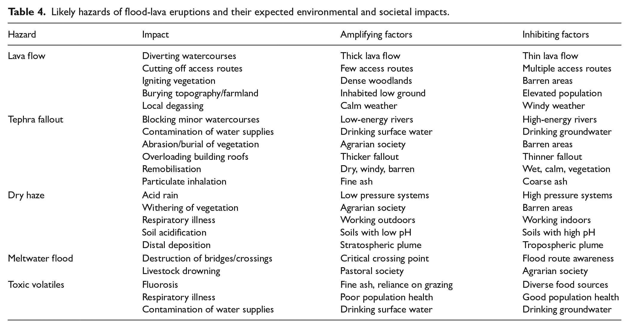
In this final section, we offer some interpretations about vulnerabilities in Icelandic society during the 10th and 18th centuries. Understanding the extent to which the severe impacts of the Laki eruption were amplified by specific societal circumstances (e.g. Table 4) is crucial if we are to understand how impactful Eldgjá was in comparison.
Likely hazards of flood-lava eruptions and their expected environmental and societal impacts.
In the 10th century, the Icelandic population was relatively more prosperous than the Scandinavian homelands (Price, 2020). Higher-status farmers had seized the best-quality land from which to control surrounding areas and establish dependent settlements, and their resilience was cemented by tenants and slave labour (Vésteinsson et al., 2002). Furthermore, although Iceland was largely pagan before 1000 AD (Gíslason, 1990), there is evidence for a growing population of Christians throughout the Settlement period (Vésteinsson et al., 2019). Therefore, fiefdoms and religious sectarianism may well have facilitated tighter local allegiances in times of hardship (e.g. local distribution of resources during times of livestock loss and famine). The ninth-century population is estimated to have been ~ 24,000 (Vésteinsson and McGovern, 2012), with a greater number of early archaeological sites identified in northern Iceland than in the south (Schmid et al., 2017), and therefore farther from the proximal hazards of the Eldgjá eruption. However, this distribution may be an artefact of selective excavation in areas of interest, as opposed to any real preference to settle in the north.
By contrast, 18th-century Iceland has been described as a ‘desperate land’ that hosted a ‘primitive society’, the standard of living having fallen since Settlement (Karlsson, 2000) for the 49,753-strong population of Iceland in 1783 (Finnsson, 1796; Jónsson, 1994). As farm ownership was the prerequisite of marriage, the fixed number of farms in Iceland limited the number of married couples – and thus, the population size (Vasey, 1996). The climate of the Little Ice Age, the smallpox epidemic of 1707–1709, and the famines of the 1750s had imposed extreme societal stresses prior to the Laki eruption (Karlsson, 2000). Limited ventilation (to conserve heat) inside traditional turf houses would have trapped pollutants produced from indoor peat burning and fish drying, cooking and ammonia production (Van Hoof and Van Dijken, 2008), thereby compounding the population’s poor health.
Tenth-century Iceland has been described as a ‘republic of independent-minded farmers in a time of burgeoning nation states’ (Price, 2020:475). At least 12 regional assemblies (Íslenska:
Allegiance-related benefits would not provide such resilience against hardship in the 18th century. After the introduction of monarchy from 1262, overseas decision-making came to supersede local governance in later centuries (Jakobsson, 2013). After c. 1660, Iceland’s necessity to account for any aid it requested from Denmark coincided with much more detailed reporting of volcanic eruptions (Thordarson, 2010). In June 1783, the Icelandic authorities took weeks to recognise the magnitude of the Laki eruption (Karlsson, 2000). Communication difficulties between Iceland and Denmark led to long delays (of several months) in Denmark providing aid – indeed, storms delayed a successful landing on Iceland until April 1784 (Wieners, 2020). The lack of emergency plans for administering aid, and identifying those eligible for loans, limited access to produce (e.g. flour, grain, timber, fish). The Danish government were largely unwilling to take decisive action without prior investigation, fearing unnecessary expenditure in the provision of unnecessary aid (Wieners, 2020). Furthermore, a trading company was the only means to administer relief and carry news between Denmark and Iceland. Officials in Iceland required instructions from Denmark, and this inability to function independently exacerbated Iceland’s widespread hardship (Karlsson, 2000). The 10th-century situation would have differed because the land contained greater natural capitals (e.g. woodlands and soil cover; Smith, 1995) and the population that required them was likely much smaller (Vésteinsson and McGovern, 2012).
The Icelandic landscape changed markedly between the 10th and 18th centuries. Whilst soil erosion has occurred throughout the Holocene, the spatial patterns and scales of soil erosion were transformed following Settlement (e.g. Arnalds, 2015; Dugmore et al., 2009; Streeter and Dugmore, 2014; Streeter et al., 2015; references therein). Erosion was associated with early woodland clearance for charcoal and timber production (e.g. Ashwell and Jackson, 1970; Church et al., 2007), volcanic and livestock grazing pressures on rangelands, and the deteriorating climate of the Little Ice Age (e.g. Dugmore et al., 2000, 2009; Streeter and Dugmore, 2014). By contrast, a comparatively warm and stable climate (for the high latitude) prevailed during the Medieval Climate Anomaly, probably favouring subsistence systems familiar to the Norse arrivals, who utilised marine and terrestrial, domestic (sheep, cattle, pig, horse and goat) and wild (e.g. great auk, walrus, seal, porpoise, trout and charr) species (Dugmore et al., 2005).
The early Icelanders enjoyed far greater natural capitals than those available for their descendants (Price, 2020; Smith, 1995), and we suggest the societal resilience to hazards from the Laki eruption was comparatively reduced. For instance, in the 10th century, straight trunks (< 12 m tall) were harnessed as building materials but, by the eighteenth, the abundance of tall native trees was reduced and patches of low-growing birch shrubs (< 3 m tall) were of limited use (Aradóttir and Arnalds, 2001; Smith, 1995). In the context of depleted supplementary resources and preceding famines, we argue that late 18th-century Icelanders had less capacity to buffer the effects of livestock mortality during the Laki eruption (Jackson, 1982). This dependency is evident in the following eyewitness account: There were hardly words to describe how the sheep just withered away. No one had the foresight to see that it would have been for the best to slaughter them all while they still had flesh on their bones and could be rounded up, and thus have food. (Steingrímsson, 1788:28)
In the 18th century, the rowing boats used in Iceland for commercial fishing had limited capacity, range and integrity compared with foreign fishing vessels (Wieners, 2020). Despite the seas around Iceland being plentiful, around a third of Icelandic fish were exported to overseas markets, reducing the catch available for Icelandic consumption (Wieners, 2020). Given the context of the 1780s, the state of commercial fishing may also have limited societal resilience to the effects of the Laki eruption (e.g. Gunnarsson, 1980; Wieners, 2020). Such limitations were also recognised at the time: . . .if more people had turned their efforts to fishing, it could have lengthened the lives of more people than in fact benefitted from it. (Steingrímsson, 1788:75)
By ~ 939 AD, the first generations of Icelanders in southern Iceland had already experienced tephra-producing eruptions (Larsen, 2018), but the early settlers likely brought coping strategies to extreme weather from their homelands, giving them pre-existing adaptive capacity (e.g. Dugmore et al., 2005). By 1783, the societal response to most eruptions in Iceland had become analogous to dealing with severe winters (i.e. livestock mortality and compromised arable or grazing land; Dugmore and Vésteinsson, 2012). Within living experience of 1783, eruptions such as those of Öræfajökull in 1727–1728 and Katla in 1755 had occurred that generated tephra fallout and other hazards (e.g. glacial meltwater floods) for communities in the south (Larsen, 2010). However, in neither the 10th nor 18th centuries was there any prior societal memory of the distinct hazards (i.e. voluminous tephra production and volatile emission) posed by flood-lava eruptions.
Concluding remarks
Flood-lava eruptions are rare, extreme events that can trigger protracted and significant environmental and societal impacts on local to hemispheric scales. Knowledge of the Laki 1783–1784 AD eruption is a key resource from which to infer the societal impacts of the Eldgjá ~ 939 AD eruption, for which there are no contemporary written records. The scarcity of other analogous (and historically documented) flood-lava eruptions results in a reliance on a few events whose circumstances differ significantly.
Based on what has been discerned of the characteristics, intensities and magnitudes of two eruptions, it appears that Eldgjá presented hazards of a variety and scale that exceeded those associated with Laki. The emplacement of the Eldgjá lava flows altered a more extensive area of topography permanently (i.e. infilling valleys, invading lowland plains, and shifting river courses) and likely wrought significant damage to extensive woodlands. Though Eldgjá probably emitted a greater volume of volatiles, prevailing climate trends and weather conditions in the case of Laki may have amplified the relative impacts of its dry hazes and stratospheric aerosol veils. It is evident that the greater volume and more widespread dispersal of tephra fallout from Eldgjá laid waste to vast tracts of land. Coupled with the ability to distribute fluorine more efficiently, Eldgjá tephra fallout could have posed a more extensive threat to the health of people and grazing livestock across Iceland. However, the extent of early human settlement within the proximal fallout zone has not yet been established. It cannot be ruled out that the early population responded to the eruption by evacuating
Despite the greater magnitude of the Eldgjá eruption, the societal circumstances (e.g. relative prosperity, increased availability of natural resources and local governance) in the 10th century may have reduced the impacts on society and provided exit routes from hardship compared with the well-documented, dire consequences of the Laki eruption.
Supplemental Material
sj-docx-1-hol-10.1177_09596836241254478 – Supplemental material for Disparate impacts of the Eldgjá and Laki flood-lava eruptions
Supplemental material, sj-docx-1-hol-10.1177_09596836241254478 for Disparate impacts of the Eldgjá and Laki flood-lava eruptions by Conner A G Morison, Clive Oppenheimer, Thorvaldur Thordarson, Anthony J Newton, William M Moreland and Andrew J Dugmore in The Holocene
Footnotes
Acknowledgements
We acknowledge Elín Hreiðarsdóttir (Fornleifastofnun Íslands) and two anonymous reviewers for their constructive comments that improved the quality of the original manuscript.
Author contributions
Funding
The lead author discloses receipt of the financial support of the Scottish International Education Trust, the Moray Endowment Fund (University of Edinburgh), the New Research Workers’ Award (Quaternary Research Association), the Geographical Club Award (Royal Geographical Society with IBG) and the Geography Centenary Research Fund (School of GeoSciences, University of Edinburgh) for the associated doctoral research project.
Supplemental material
Supplemental material for this article is available online.
References
Supplementary Material
Please find the following supplemental material available below.
For Open Access articles published under a Creative Commons License, all supplemental material carries the same license as the article it is associated with.
For non-Open Access articles published, all supplemental material carries a non-exclusive license, and permission requests for re-use of supplemental material or any part of supplemental material shall be sent directly to the copyright owner as specified in the copyright notice associated with the article.